Bridge Statistics for Utica, New York (NY)
Condition, Traffic, Stress, Structural Evaluation, Project Costs
- National Bridge Inventory (NBI) Statistics
- 122Number of bridges
- 1,608ft / 490mTotal length
- $239,612,000Total costs
- 1,219,282Total average daily traffic
- 64,574Total average daily truck traffic
- National Bridge Inventory (NBI) Registered Bridges for Utica
- No street view available for this location
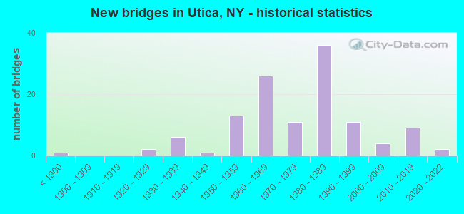
- New bridges - historical statistics
- 1Before 1900
- 21920-1929
- 61930-1939
- 11940-1949
- 131950-1959
- 261960-1969
- 111970-1979
- 361980-1989
- 111990-1999
- 42000-2009
- 92010-2019
- 22020-2022
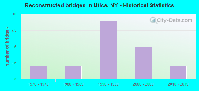
- Reconstructed bridges - Historical Statistics
- 21970-1979
- 21980-1989
- 91990-1999
- 52000-2009
- 22010-2019
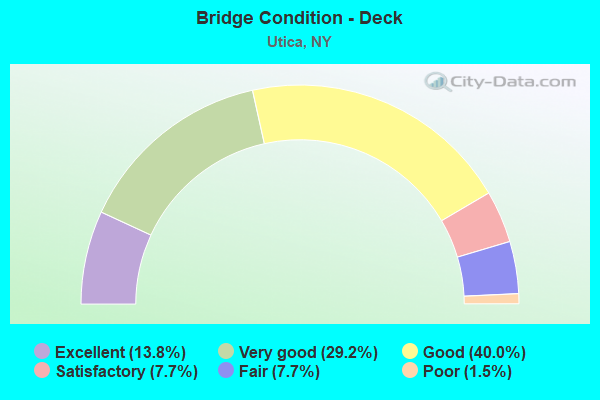
- Bridge Condition - Deck
- 13.8%Excellent
- 29.2%Very good
- 40.0%Good
- 7.7%Satisfactory
- 7.7%Fair
- 1.5%Poor
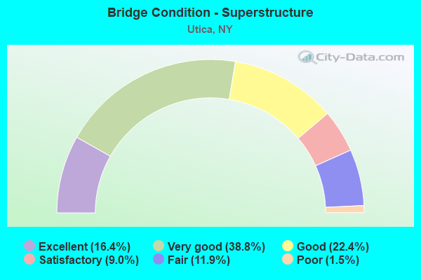
- Bridge Condition - Superstructure
- 16.4%Excellent
- 38.8%Very good
- 22.4%Good
- 9.0%Satisfactory
- 11.9%Fair
- 1.5%Poor
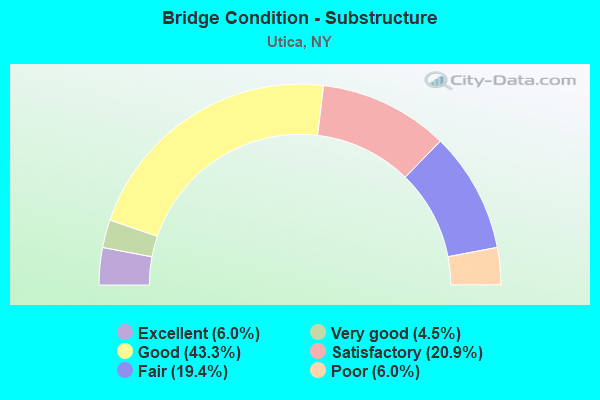
- Bridge Condition - Substructure
- 6.0%Excellent
- 4.5%Very good
- 43.3%Good
- 20.9%Satisfactory
- 19.4%Fair
- 6.0%Poor
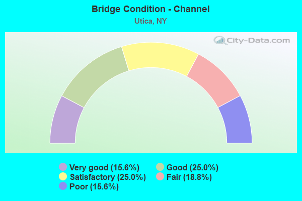
- Bridge Condition - Channel
- 15.6%Very good
- 25.0%Good
- 25.0%Satisfactory
- 18.8%Fair
- 15.6%Poor
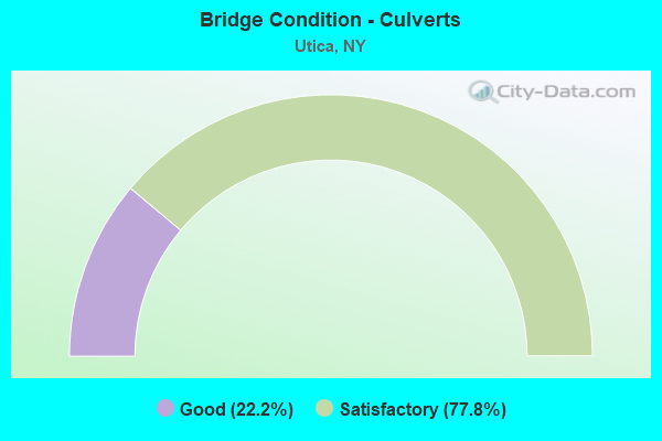
- Bridge Condition - Culverts
- 22.2%Good
- 77.8%Satisfactory
Find on map >> Show street view
Structure Number: 1002219, Location: JCT 5+8 NEW HARTFORD (Lat: 43.080553, Lng: -75.292464), Route carried "on" structure: State highway 8, Year Built: 2021, Status: Open, Structure Length: 6.83m (22.41ft), Average Daily Traffic: 27,446 (year 2017), Truck Traffic: 6%, Average Future Daily Traffic: 27,574 (year 2040), Design Load: HS 20, Features Intersected: 5 52610440 WB, RTE 5
Minimum Vertical Clearance: 30+ m (98+ ft), Kilometerpoint: 0.193, Lanes on structure: 3, Lanes under structure: 6, Base Highway Network: Yes, Owner: State Highway Agency, Approaching Roadway Width: 13.4m (44.0ft), Skew: 2 degrees, Material/Design: Steel, Design/Construction: Stringer/Multi-beam, Number Of Spans In Main Unit: 2, Length of Maximum Span: 34.7m (113.8ft), Curb-To-Curb Width: 12.2m (40.0ft), Out-to-Out Width: 13.4m (44.0ft)
Condition: Deck: Excellent, Superstructure: Excellent, Substructure: Excellent, Operating Rating: 56.2 metric tons, Method Used To Determine Operating Rating: Load Factor (LF), Inventory Rating: 33.6 metric tons, Method Used To Determine Inventory Rating: Load Factor (LF), Structural Evaluation: Superior to present desirable criteria, Deck Geometry: Meets minimum limits, Underclear: Meets minimum limits, Approach Roadway Alignment: Equal to present desirable criteria, Length Of Structure Improvement: 6.76m (22.18ft), Designated Inspection Frequency: Every 24 months, Inspection Date: November 2021, Bridge Improvement Cost: $2,865,000, Roadway Improvement Cost: $1,678,000, Total Project Cost: $4,542,000 ( Estimate for 2021), Deck Structure Type: Concrete Cast-file-Place, Wearing Surface/Protective System: Wearing Surface: Monolithic Concrete, Deck Protection: Epoxy Coated Reinforcing
Find on map >> Show street view
Structure Number: 1002221, Location: 0.2 MI N JCT SH 5 & SH 8 (Lat: 43.081592, Lng: -75.290522), Route carried "on" structure: State highway 5, Year Built: 1960, Status: Open, Structure Length: 3.81m (12.50ft), Average Daily Traffic: 10,790 (year 2011), Truck Traffic: 5%, Average Future Daily Traffic: 13,466 (year 2040), Design Load: HS 20, Features Intersected: SAUQUOIT CREEK
Minimum Vertical Clearance: 30+ m (98+ ft), Kilometerpoint: 29.364, Lanes on structure: 3, Base Highway Network: Yes, Owner: State Highway Agency, Approaching Roadway Width: 11.0m (36.1ft), Material/Design: Steel, Design/Construction: Stringer/Multi-beam, Number Of Spans In Main Unit: 2, Length of Maximum Span: 18.2m (59.7ft), Curb or Sidewalk Widths: Left: 0.5m (1.6ft), Right: 0.5m (1.6ft), Curb-To-Curb Width: 14.9m (48.9ft), Out-to-Out Width: 16.5m (54.1ft)
Condition: Deck: Good, Superstructure: Satisfactory, Substructure: Poor, Channel: Fair, Operating Rating: 69.9 metric tons, Method Used To Determine Operating Rating: Load Factor (LF), Inventory Rating: 41.7 metric tons, Method Used To Determine Inventory Rating: Load Factor (LF), Structural Evaluation: Meets minimum limits, Deck Geometry: Meets minimum limits, Waterway Adequacy: Meets minimum limits, Approach Roadway Alignment: Equal to present desirable criteria, Length Of Structure Improvement: 3.81m (12.50ft), Designated Inspection Frequency: Every 24 months, Inspection Date: July 2020, Bridge Improvement Cost: $1,107,000, Roadway Improvement Cost: $648,000, Total Project Cost: $1,755,000 ( Estimate for 2021), Deck Structure Type: Concrete Cast-file-Place, Wearing Surface/Protective System: Wearing Surface: Bituminous, Membrane: Other
Find on map >> Show street view
Structure Number: 1002222, Location: 02MI N JCT RTS 5+8 (Lat: 43.081467, Lng: -75.290253), Route carried "on" structure: State highway 5, Year Built: 1960, Status: Open, Structure Length: 3.81m (12.50ft), Average Daily Traffic: 10,790 (year 2011), Truck Traffic: 5%, Average Future Daily Traffic: 13,466 (year 2040), Design Load: HS 20, Features Intersected: SAUQUOIT CREEK
Minimum Vertical Clearance: 30+ m (98+ ft), Kilometerpoint: 29.364, Lanes on structure: 3, Base Highway Network: Yes, Owner: State Highway Agency, Approaching Roadway Width: 11.0m (36.1ft), Material/Design: Steel, Design/Construction: Stringer/Multi-beam, Number Of Spans In Main Unit: 2, Length of Maximum Span: 18.2m (59.7ft), Curb or Sidewalk Widths: Left: 0.5m (1.6ft), Right: 0.5m (1.6ft), Curb-To-Curb Width: 15.2m (49.9ft), Out-to-Out Width: 16.8m (55.1ft)
Condition: Deck: Good, Superstructure: Satisfactory, Substructure: Poor, Channel: Poor, Operating Rating: 70.8 metric tons, Method Used To Determine Operating Rating: Load Testing, Inventory Rating: 41.7 metric tons, Method Used To Determine Inventory Rating: Load Testing, Structural Evaluation: Meets minimum limits, Deck Geometry: Meets minimum limits, Waterway Adequacy: Meets minimum limits, Approach Roadway Alignment: Equal to present desirable criteria, Length Of Structure Improvement: 3.77m (12.37ft), Designated Inspection Frequency: Every 24 months, Inspection Date: November 2021, Bridge Improvement Cost: $1,122,000, Roadway Improvement Cost: $657,000, Total Project Cost: $1,779,000 ( Estimate for 2021), Deck Structure Type: Concrete Cast-file-Place, Wearing Surface/Protective System: Wearing Surface: Bituminous, Membrane: Other
Find on map >> Show street view
Structure Number: 1002239, Location: 2.3 MI S JCT SH 5 & SH 5S (Lat: 43.085617, Lng: -75.282953), Route carried "on" structure: State highway 5, Year Built: 1960, Year Reconstructed: 1995, Status: Open, Structure Length: 2.96m (9.71ft), Average Daily Traffic: 35,801 (year 2012), Truck Traffic: 10%, Average Future Daily Traffic: 44,679 (year 2040), Design Load: HS 20, Features Intersected: NY SUSQUEHANNA & WESTERN
Minimum Vertical Clearance: 30+ m (98+ ft), Kilometerpoint: 30.201, Lanes on structure: 4, Base Highway Network: Yes, Owner: State Highway Agency, Approaching Roadway Width: 20.7m (67.9ft), Skew: 26 degrees, Material/Design: Steel, Design/Construction: Stringer/Multi-beam, Number Of Spans In Main Unit: 1, Length of Maximum Span: 25.6m (84.0ft), Curb-To-Curb Width: 21.9m (71.9ft), Out-to-Out Width: 23.5m (77.1ft)
Condition: Deck: Good, Superstructure: Good, Substructure: Fair, Operating Rating: 58.1 metric tons, Method Used To Determine Operating Rating: Load Factor (LF), Inventory Rating: 38.1 metric tons, Method Used To Determine Inventory Rating: Load Factor (LF), Structural Evaluation: Somewhat better than minimum adequacy, Deck Geometry: Better than present minimum criteria, Underclear: Somewhat better than minimum adequacy, Approach Roadway Alignment: Equal to present desirable criteria, Length Of Structure Improvement: 2.95m (9.68ft), Designated Inspection Frequency: Every 24 months, Critical Feature Inspection Frequency: Every 24 months, Inspection Date: October 2021, Critical Feature Inspection Date: October 2021, Bridge Improvement Cost: $4,331,000, Roadway Improvement Cost: $2,536,000, Total Project Cost: $6,867,000 ( Estimate for 2021), Deck Structure Type: Concrete Cast-file-Place, Wearing Surface/Protective System: Wearing Surface: Integral Concrete, Deck Protection: Epoxy Coated Reinforcing
Find on map >> Show street view
Structure Number: 1002249, Location: 2.2 MI S JCT RTS 5 & 5S (Lat: 43.086603, Lng: -75.280156), Route carried "on" structure: State highway 5, Year Built: 1960, Year Reconstructed: 1995, Status: Open, Structure Length: 6.92m (22.70ft), Average Daily Traffic: 35,801 (year 2013), Truck Traffic: 10%, Average Future Daily Traffic: 44,679 (year 2040), Design Load: HS 20, Features Intersected: FRENCH ROAD
Minimum Vertical Clearance: 30+ m (98+ ft), Kilometerpoint: 30.362, Lanes on structure: 5, Lanes under structure: 4, Base Highway Network: Yes, Owner: State Highway Agency, Approaching Roadway Width: 25.6m (84.0ft), Skew: 24 degrees, Material/Design: Steel, Design/Construction: Stringer/Multi-beam, Number Of Spans In Main Unit: 4, Length of Maximum Span: 21.0m (68.9ft), Curb-To-Curb Width: 25.1m (82.3ft), Out-to-Out Width: 26.7m (87.6ft)
Condition: Deck: Good, Superstructure: Satisfactory, Substructure: Fair, Operating Rating: 61.7 metric tons, Method Used To Determine Operating Rating: Load Factor (LF), Inventory Rating: 34.5 metric tons, Method Used To Determine Inventory Rating: Load Factor (LF), Structural Evaluation: Somewhat better than minimum adequacy, Deck Geometry: Better than present minimum criteria, Underclear: Somewhat better than minimum adequacy, Approach Roadway Alignment: Equal to present desirable criteria, Length Of Structure Improvement: 6.94m (22.77ft), Designated Inspection Frequency: Every 24 months, Inspection Date: November 2021, Bridge Improvement Cost: $3,123,000, Roadway Improvement Cost: $1,829,000, Total Project Cost: $4,951,000 ( Estimate for 2021), Deck Structure Type: Concrete Cast-file-Place, Wearing Surface/Protective System: Wearing Surface: Integral Concrete, Deck Protection: Epoxy Coated Reinforcing
Find on map >> Show street view
Structure Number: 1002259, Location: 1.8 MI S JCT SH 5 & SH 5S (Lat: 43.088167, Lng: -75.276378), Route carried "on" structure: State highway 5, Year Built: 1960, Year Reconstructed: 1995, Status: Open, Structure Length: 4.88m (16.01ft), Average Daily Traffic: 30,543 (year 2013), Truck Traffic: 10%, Average Future Daily Traffic: 38,117 (year 2040), Design Load: HS 20, Features Intersected: FRENCH ROAD RAMP
Minimum Vertical Clearance: 30+ m (98+ ft), Kilometerpoint: 30.732, Lanes on structure: 5, Lanes under structure: 2, Base Highway Network: Yes, Owner: State Highway Agency, Approaching Roadway Width: 25.0m (82.0ft), Skew: 23 degrees, Material/Design: Steel, Design/Construction: Stringer/Multi-beam, Number Of Spans In Main Unit: 3, Length of Maximum Span: 19.5m (64.0ft), Curb-To-Curb Width: 25.1m (82.3ft), Out-to-Out Width: 26.7m (87.6ft)
Condition: Deck: Good, Superstructure: Satisfactory, Substructure: Fair, Operating Rating: 64.4 metric tons, Method Used To Determine Operating Rating: Load Factor (LF), Inventory Rating: 37.2 metric tons, Method Used To Determine Inventory Rating: Load Factor (LF), Structural Evaluation: Somewhat better than minimum adequacy, Deck Geometry: Better than present minimum criteria, Underclear: Meets minimum limits, Approach Roadway Alignment: Equal to present desirable criteria, Length Of Structure Improvement: 4.87m (15.98ft), Designated Inspection Frequency: Every 24 months, Inspection Date: November 2021, Bridge Improvement Cost: $2,199,000, Roadway Improvement Cost: $1,288,000, Total Project Cost: $3,487,000 ( Estimate for 2021), Deck Structure Type: Concrete Cast-file-Place, Wearing Surface/Protective System: Wearing Surface: Integral Concrete, Deck Protection: Epoxy Coated Reinforcing
Find on map >> Show street view
Structure Number: 1002269, Location: 1.5 MI S JCT SH 5 & SH 5S (Lat: 43.089808, Lng: -75.272583), Route carried "on" structure: State highway 5, Year Built: 1960, Year Reconstructed: 1995, Status: Open, Structure Length: 7.53m (24.70ft), Average Daily Traffic: 30,543 (year 2013), Truck Traffic: 10%, Average Future Daily Traffic: 38,117 (year 2040), Design Load: HS 20, Features Intersected: NY SUSQUEHANNA & WESTERN
Minimum Vertical Clearance: 30+ m (98+ ft), Kilometerpoint: 31.102, Lanes on structure: 6, Base Highway Network: Yes, Owner: State Highway Agency, Approaching Roadway Width: 31.7m (104.0ft), Skew: 25 degrees, Material/Design: Steel, Design/Construction: Stringer/Multi-beam, Number Of Spans In Main Unit: 3, Length of Maximum Span: 24.0m (78.7ft), Curb-To-Curb Width: 30.9m (101.4ft), Out-to-Out Width: 32.5m (106.6ft)
Condition: Deck: Good, Superstructure: Good, Substructure: Fair, Inventory Rating: 61.7 metric tons, Method Used To Determine Inventory Rating: Load Factor (LF), Structural Evaluation: Somewhat better than minimum adequacy, Deck Geometry: Superior to present desirable criteria, Underclear: Better than present minimum criteria, Approach Roadway Alignment: Equal to present desirable criteria, Length Of Structure Improvement: 7.52m (24.67ft), Designated Inspection Frequency: Every 24 months, Inspection Date: November 2021, Bridge Improvement Cost: $4,212,000, Roadway Improvement Cost: $2,467,000, Total Project Cost: $6,679,000 ( Estimate for 2021), Deck Structure Type: Concrete Cast-file-Place, Wearing Surface/Protective System: Wearing Surface: Integral Concrete, Deck Protection: Epoxy Coated Reinforcing
Find on map >> Show street view
Structure Number: 1002291, Location: JCT.RTES 5 & 5S (Lat: 43.108278, Lng: -75.238578), Route carried "on" structure: State highway 5, Year Built: 1990, Status: Open, Structure Length: 9.78m (32.09ft), Average Daily Traffic: 13,175 (year 2007), Truck Traffic: 5%, Design Load: HS 20, Features Intersected: CSX TRANS/AMTRAK, NY SUS
Minimum Vertical Clearance: 30+ m (98+ ft), Kilometerpoint: 0.209, Lanes on structure: 2, Base Highway Network: Yes, Owner: State Highway Agency, Approaching Roadway Width: 12.2m (40.0ft), Material/Design: Steel continuous, Design/Construction: Stringer/Multi-beam, Number Of Spans In Main Unit: 2, Length of Maximum Span: 48.4m (158.8ft), Curb-To-Curb Width: 12.0m (39.4ft), Out-to-Out Width: 13.0m (42.7ft)
Condition: Deck: Very good, Superstructure: Very good, Substructure: Good, Operating Rating: 76.2 metric tons, Method Used To Determine Operating Rating: Load Factor (LF), Inventory Rating: 40.8 metric tons, Method Used To Determine Inventory Rating: Load Factor (LF), Structural Evaluation: Better than present minimum criteria, Deck Geometry: Equal to present minimum criteria, Underclear: Better than present minimum criteria, Approach Roadway Alignment: Equal to present desirable criteria, Length Of Structure Improvement: 9.78m (32.09ft), Designated Inspection Frequency: Every 24 months, Inspection Date: October 2020, Bridge Improvement Cost: $2,137,000, Roadway Improvement Cost: $1,252,000, Total Project Cost: $3,389,000 ( Estimate for 2021), Deck Structure Type: Concrete Cast-file-Place, Wearing Surface/Protective System: Wearing Surface: Integral Concrete, Deck Protection: Epoxy Coated Reinforcing
Find on map >> Show street view
Structure Number: 1002292, Location: JCT.RTES 5 & 5S (Lat: 43.108044, Lng: -75.238514), Route carried "on" structure: State highway 5, Year Built: 1990, Status: Open, Structure Length: 9.78m (32.09ft), Average Daily Traffic: 10,173 (year 2019), Truck Traffic: 4%, Average Future Daily Traffic: 11,721 (year 2040), Design Load: HS 20, Features Intersected: CSX TRANS/AMTRAK, NY SUS
Minimum Vertical Clearance: 30+ m (98+ ft), Kilometerpoint: 0.209, Lanes on structure: 2, Base Highway Network: Yes, Owner: State Highway Agency, Approaching Roadway Width: 12.2m (40.0ft), Material/Design: Steel continuous, Design/Construction: Stringer/Multi-beam, Number Of Spans In Main Unit: 2, Length of Maximum Span: 48.4m (158.8ft), Curb-To-Curb Width: 12.0m (39.4ft), Out-to-Out Width: 13.0m (42.7ft)
Condition: Deck: Excellent, Superstructure: Very good, Substructure: Very good, Operating Rating: 76.2 metric tons, Method Used To Determine Operating Rating: Load Factor (LF), Inventory Rating: 40.8 metric tons, Method Used To Determine Inventory Rating: Load Factor (LF), Structural Evaluation: Equal to present desirable criteria, Deck Geometry: Equal to present minimum criteria, Underclear: Better than present minimum criteria, Approach Roadway Alignment: Equal to present desirable criteria, Length Of Structure Improvement: 9.78m (32.09ft), Designated Inspection Frequency: Every 24 months, Inspection Date: October 2020, Bridge Improvement Cost: $2,138,000, Roadway Improvement Cost: $1,252,000, Total Project Cost: $3,390,000 ( Estimate for 2021), Deck Structure Type: Concrete Cast-file-Place, Wearing Surface/Protective System: Wearing Surface: Integral Concrete, Deck Protection: Epoxy Coated Reinforcing
Find on map >> Show street view
Structure Number: 1002301, Location: .5 MI N JCT SH 5 & SH 5S (Lat: 43.111478, Lng: -75.236703), Route carried "on" structure: Interstate 790, Year Built: 1989, Status: Open, Structure Length: 18.04m (59.19ft), Average Daily Traffic: 28,103 (year 2009), Truck Traffic: 7%, Design Load: HS 20, Features Intersected: MOHAWK ADIR & NO, MOHAWK
Minimum Vertical Clearance: 30+ m (98+ ft), Kilometerpoint: 0.611, Lanes on structure: 3, Base Highway Network: Yes, Owner: State Highway Agency, Approaching Roadway Width: 16.8m (55.1ft), Skew: 5 degrees, Material/Design: Steel continuous, Design/Construction: Stringer/Multi-beam, Number Of Spans In Main Unit: 4, Length of Maximum Span: 49.6m (162.7ft), Curb-To-Curb Width: 16.8m (55.1ft), Out-to-Out Width: 19.2m (63.0ft)
Condition: Deck: Good, Superstructure: Very good, Substructure: Satisfactory, Channel: Very good, Operating Rating: 78.9 metric tons, Method Used To Determine Operating Rating: Load Factor (LF), Inventory Rating: 47.2 metric tons, Method Used To Determine Inventory Rating: Load Factor (LF), Structural Evaluation: Equal to present minimum criteria, Deck Geometry: Equal to present minimum criteria, Underclear: Better than present minimum criteria, Waterway Adequacy: Equal to present minimum criteria, Approach Roadway Alignment: Equal to present desirable criteria, Length Of Structure Improvement: 18.04m (59.19ft), Designated Inspection Frequency: Every 24 months, Inspection Date: July 2021, Bridge Improvement Cost: $6,421,000, Roadway Improvement Cost: $3,760,000, Total Project Cost: $10,181,000 ( Estimate for 2021), Deck Structure Type: Concrete Cast-file-Place, Wearing Surface/Protective System: Wearing Surface: Integral Concrete, Deck Protection: Epoxy Coated Reinforcing
Find on map >> Show street view
Structure Number: 1002302, Location: .5 MI N JCT SH 5 & SH 5S (Lat: 43.111517, Lng: -75.236433), Route carried "on" structure: Interstate 790, Year Built: 1989, Status: Open, Structure Length: 18.50m (60.70ft), Average Daily Traffic: 16,747 (year 2019), Truck Traffic: 4%, Average Future Daily Traffic: 19,296 (year 2040), Design Load: HS 20, Features Intersected: MOHAWK ADIR & NO, MOHAWK
Minimum Vertical Clearance: 30+ m (98+ ft), Kilometerpoint: 0.611, Lanes on structure: 3, Base Highway Network: Yes, Owner: State Highway Agency, Approaching Roadway Width: 15.8m (51.8ft), Skew: 5 degrees, Material/Design: Steel continuous, Design/Construction: Stringer/Multi-beam, Number Of Spans In Main Unit: 4, Length of Maximum Span: 59.4m (194.9ft), Curb-To-Curb Width: 15.7m (51.5ft), Out-to-Out Width: 16.6m (54.5ft)
Condition: Deck: Very good, Superstructure: Very good, Substructure: Good, Channel: Good, Operating Rating: 88.9 metric tons, Method Used To Determine Operating Rating: Load Factor (LF), Inventory Rating: 53.5 metric tons, Method Used To Determine Inventory Rating: Load Factor (LF), Structural Evaluation: Better than present minimum criteria, Deck Geometry: Somewhat better than minimum adequacy, Underclear: High priority of corrective action, Waterway Adequacy: Equal to present desirable criteria, Approach Roadway Alignment: Equal to present desirable criteria, Length Of Structure Improvement: 18.50m (60.70ft), Designated Inspection Frequency: Every 24 months, Inspection Date: July 2021, Bridge Improvement Cost: $5,373,000, Roadway Improvement Cost: $3,147,000, Total Project Cost: $8,520,000 ( Estimate for 2021), Deck Structure Type: Concrete Cast-file-Place, Wearing Surface/Protective System: Wearing Surface: Integral Concrete, Deck Protection: Epoxy Coated Reinforcing
Find on map >> Show street view
Structure Number: 1002321, Location: JCT OF I90 & I790 (Lat: 43.122072, Lng: -75.230764), Route carried "on" structure: State highway 8, Year Built: 1988, Status: Open, Structure Length: 10.73m (35.20ft), Average Daily Traffic: 7,010 (year 2020), Truck Traffic: 10%, Average Future Daily Traffic: 8,748 (year 2040), Design Load: HS 20, Features Intersected: 790I 790I WB, 90IX WB, R
Minimum Vertical Clearance: 30+ m (98+ ft), Kilometerpoint: 32.421, Lanes on structure: 3, Lanes under structure: 9, Base Highway Network: Yes, Owner: State Highway Agency, Approaching Roadway Width: 12.5m (41.0ft), Material/Design: Steel continuous, Design/Construction: Stringer/Multi-beam, Number Of Spans In Main Unit: 3, Length of Maximum Span: 39.6m (129.9ft), Curb-To-Curb Width: 12.7m (41.7ft), Out-to-Out Width: 13.7m (44.9ft)
Condition: Deck: Very good, Superstructure: Good, Substructure: Good, Operating Rating: 59.0 metric tons, Method Used To Determine Operating Rating: Load and Resistance Factor Rating (LRFR) rating reported by rating factor(RF) method using HL-93 loadings, Inventory Rating: 45.7 metric tons, Method Used To Determine Inventory Rating: Load and Resistance Factor Rating (LRFR) rating reported by rating factor(RF) method using HL-93 loadings, Structural Evaluation: Better than present minimum criteria, Deck Geometry: Meets minimum limits, Underclear: Meets minimum limits, Approach Roadway Alignment: Equal to present desirable criteria, Length Of Structure Improvement: 10.72m (35.17ft), Designated Inspection Frequency: Every 24 months, Inspection Date: April 2020, Bridge Improvement Cost: $2,372,000, Roadway Improvement Cost: $1,389,000, Total Project Cost: $3,761,000 ( Estimate for 2021), Deck Structure Type: Concrete Cast-file-Place, Wearing Surface/Protective System: Wearing Surface: Integral Concrete, Deck Protection: Epoxy Coated Reinforcing
Find on map >> Show street view
Structure Number: 1002322, Location: JCT OF I90 & I790 (Lat: 43.121844, Lng: -75.230497), Route carried "on" structure: State highway 8, Year Built: 1988, Status: Open, Structure Length: 10.73m (35.20ft), Average Daily Traffic: 7,010 (year 2020), Truck Traffic: 10%, Average Future Daily Traffic: 8,748 (year 2040), Design Load: HS 20, Features Intersected: 790I 790I WB, 90IX WB, R
Minimum Vertical Clearance: 30+ m (98+ ft), Kilometerpoint: 32.421, Lanes on structure: 3, Lanes under structure: 9, Base Highway Network: Yes, Owner: State Highway Agency, Approaching Roadway Width: 15.8m (51.8ft), Material/Design: Steel continuous, Design/Construction: Stringer/Multi-beam, Number Of Spans In Main Unit: 3, Length of Maximum Span: 39.6m (129.9ft), Curb-To-Curb Width: 15.7m (51.5ft), Out-to-Out Width: 16.6m (54.5ft)
Condition: Deck: Very good, Superstructure: Good, Substructure: Good, Operating Rating: 54.4 metric tons, Method Used To Determine Operating Rating: Load and Resistance Factor Rating (LRFR) rating reported by rating factor(RF) method using HL-93 loadings, Inventory Rating: 41.8 metric tons, Method Used To Determine Inventory Rating: Load and Resistance Factor Rating (LRFR) rating reported by rating factor(RF) method using HL-93 loadings, Structural Evaluation: Better than present minimum criteria, Deck Geometry: Somewhat better than minimum adequacy, Underclear: Meets minimum limits, Approach Roadway Alignment: Equal to present desirable criteria, Length Of Structure Improvement: 10.72m (35.17ft), Designated Inspection Frequency: Every 24 months, Inspection Date: April 2020, Bridge Improvement Cost: $2,862,000, Roadway Improvement Cost: $1,676,000, Total Project Cost: $4,538,000 ( Estimate for 2021), Deck Structure Type: Concrete Cast-file-Place, Wearing Surface/Protective System: Wearing Surface: Integral Concrete, Deck Protection: Epoxy Coated Reinforcing
Find on map >> Show street view
Structure Number: 1002341, Location: .2 MILE N JCT I90 & S H 8 (Lat: 43.123492, Lng: -75.229703), Route carried "on" structure: State highway 8, Year Built: 1988, Status: Open, Structure Length: 7.89m (25.89ft), Average Daily Traffic: 418 (year 2017), Truck Traffic: 10%, Average Future Daily Traffic: 521 (year 2040), Design Load: HS 20, Features Intersected: RTE I790, RTE I790, RIVE
Minimum Vertical Clearance: 30+ m (98+ ft), Kilometerpoint: 0.000, Lanes on structure: 3, Lanes under structure: 6, Owner: State Highway Agency, Approaching Roadway Width: 15.5m (50.9ft), Material/Design: Steel continuous, Design/Construction: Stringer/Multi-beam, Number Of Spans In Main Unit: 3, Length of Maximum Span: 26.5m (86.9ft), Curb-To-Curb Width: 15.7m (51.5ft), Out-to-Out Width: 16.6m (54.5ft)
Condition: Deck: Very good, Superstructure: Very good, Substructure: Satisfactory, Inventory Rating: 59.9 metric tons, Method Used To Determine Inventory Rating: Load Factor (LF), Structural Evaluation: Equal to present minimum criteria, Deck Geometry: Somewhat better than minimum adequacy, Underclear: High priority of corrective action, Approach Roadway Alignment: Equal to present desirable criteria, Length Of Structure Improvement: 7.89m (25.89ft), Designated Inspection Frequency: Every 24 months, Inspection Date: April 2020, Bridge Improvement Cost: $2,548,000, Roadway Improvement Cost: $1,492,000, Total Project Cost: $4,040,000 ( Estimate for 2021), Deck Structure Type: Concrete Cast-file-Place, Wearing Surface/Protective System: Wearing Surface: Integral Concrete
Find on map >> Show street view
Structure Number: 1002342, Location: .2 MI N.JCT. 90I & RTE 8 (Lat: 43.123400, Lng: -75.229367), Route carried "on" structure: State highway 8, Year Built: 1988, Status: Open, Structure Length: 7.41m (24.31ft), Average Daily Traffic: 6,564 (year 2017), Truck Traffic: 10%, Average Future Daily Traffic: 8,191 (year 2040), Design Load: HS 20, Features Intersected: RTE I790, RTE I790, Rive
Minimum Vertical Clearance: 30+ m (98+ ft), Kilometerpoint: 36.251, Lanes on structure: 3, Lanes under structure: 6, Base Highway Network: Yes, Owner: State Highway Agency, Approaching Roadway Width: 16.2m (53.1ft), Material/Design: Steel continuous, Design/Construction: Stringer/Multi-beam, Number Of Spans In Main Unit: 3, Length of Maximum Span: 24.9m (81.7ft), Curb-To-Curb Width: 15.7m (51.5ft), Out-to-Out Width: 16.6m (54.5ft)
Condition: Deck: Very good, Superstructure: Very good, Substructure: Satisfactory, Operating Rating: 50.5 metric tons, Method Used To Determine Operating Rating: Load and Resistance Factor Rating (LRFR) rating reported by rating factor(RF) method using HL-93 loadings, Inventory Rating: 38.6 metric tons, Method Used To Determine Inventory Rating: Load and Resistance Factor Rating (LRFR) rating reported by rating factor(RF) method using HL-93 loadings, Structural Evaluation: Equal to present minimum criteria, Deck Geometry: Somewhat better than minimum adequacy, Underclear: Meets minimum limits, Approach Roadway Alignment: Equal to present desirable criteria, Length Of Structure Improvement: 7.40m (24.28ft), Designated Inspection Frequency: Every 24 months, Inspection Date: April 2020, Bridge Improvement Cost: $2,358,000, Roadway Improvement Cost: $1,381,000, Total Project Cost: $3,739,000 ( Estimate for 2021), Deck Structure Type: Concrete Cast-file-Place, Wearing Surface/Protective System: Wearing Surface: Integral Concrete
Find on map >> Show street view
Structure Number: 1002351, Location: .2 MI S JCT SH 5 & SH921 (Lat: 43.116783, Lng: -75.212336), Route carried "on" structure: State highway , Year Built: 1963, Status: Open, Structure Length: 1.40m (4.59ft), Average Daily Traffic: 6,291 (year 2014), Truck Traffic: 3%, Average Future Daily Traffic: 7,642 (year 2040), Design Load: HS 20, Features Intersected: REALL CREEK, Facility Carried by Structure: RIVER ROAD WB
Minimum Vertical Clearance: 30+ m (98+ ft), Kilometerpoint: 1.899, Lanes on structure: 3, Owner: City or Municipal Highway Agency, Approaching Roadway Width: 11.0m (36.1ft), Skew: 3 degrees, Material/Design: Concrete continuous, Design/Construction: Culvert, Number Of Spans In Main Unit: 2, Length of Maximum Span: 6.1m (20.0ft), Curb or Sidewalk Widths: Left: 1.5m (4.9ft), Right: 1.5m (4.9ft), Curb-To-Curb Width: 11.1m (36.4ft), Out-to-Out Width: 14.7m (48.2ft)
Condition: Channel: Satisfactory, Culverts: Satisfactory, Inventory Rating: 62.6 metric tons, Method Used To Determine Inventory Rating: Load Factor (LF), Structural Evaluation: Equal to present minimum criteria, Deck Geometry: High priority of replacement, Waterway Adequacy: Meets minimum limits, Approach Roadway Alignment: Equal to present desirable criteria, Length Of Structure Improvement: 1.40m (4.59ft), Designated Inspection Frequency: Every 24 months, Inspection Date: May 2021, Bridge Improvement Cost: $401,000, Roadway Improvement Cost: $235,000, Total Project Cost: $636,000 ( Estimate for 2021)
Find on map >> Show street view
Structure Number: 1002352, Location: .2 MI S JCT SH 5 & SH921 (Lat: 43.116081, Lng: -75.212853), Route carried "on" structure: State highway , Year Built: 1963, Status: Open, Structure Length: 1.22m (4.00ft), Average Daily Traffic: 6,291 (year 2014), Truck Traffic: 3%, Average Future Daily Traffic: 7,642 (year 2040), Design Load: HS 20, Features Intersected: REALL CREEK, Facility Carried by Structure: RIVER ROAD EB
Minimum Vertical Clearance: 30+ m (98+ ft), Kilometerpoint: 1.899, Lanes on structure: 3, Owner: City or Municipal Highway Agency, Approaching Roadway Width: 11.0m (36.1ft), Skew: 1 degrees, Material/Design: Concrete, Design/Construction: Culvert, Number Of Spans In Main Unit: 2, Length of Maximum Span: 5.5m (18.0ft), Curb or Sidewalk Widths: Left: 1.4m (4.6ft), Right: 1.4m (4.6ft), Curb-To-Curb Width: 11.1m (36.4ft), Out-to-Out Width: 14.6m (47.9ft)
Condition: Channel: Fair, Culverts: Satisfactory, Inventory Rating: 63.5 metric tons, Method Used To Determine Inventory Rating: Load Factor (LF), Structural Evaluation: Equal to present minimum criteria, Deck Geometry: High priority of replacement, Waterway Adequacy: Meets minimum limits, Approach Roadway Alignment: Equal to present desirable criteria, Length Of Structure Improvement: 1.21m (3.97ft), Designated Inspection Frequency: Every 24 months, Inspection Date: May 2021, Bridge Improvement Cost: $346,000, Roadway Improvement Cost: $202,000, Total Project Cost: $548,000 ( Estimate for 2021)
Find on map >> Show street view
Structure Number: 105119, Location: 4.5 MI E JCT RTS 5S & 12 (Lat: 43.085844, Lng: -75.164133), Route carried "on" structure: County highway , Year Built: 1968, Status: Open, Structure Length: 4.94m (16.21ft), Average Daily Traffic: 5,527 (year 2018), Truck Traffic: 6%, Average Future Daily Traffic: 6,838 (year 2040), Design Load: HS 20, Features Intersected: 5S 5S 23021010 WB, RTE, Facility Carried by Structure: DYKE ROAD
Minimum Vertical Clearance: 30+ m (98+ ft), Kilometerpoint: 0.129, Lanes on structure: 2, Lanes under structure: 4, Owner: State Highway Agency, Approaching Roadway Width: 7.3m (24.0ft), Skew: 1 degrees, Material/Design: Steel, Design/Construction: Stringer/Multi-beam, Number Of Spans In Main Unit: 3, Length of Maximum Span: 25.2m (82.7ft), Curb or Sidewalk Widths: Left: 0.3m (1.0ft), Right: 0.3m (1.0ft), Curb-To-Curb Width: 8.5m (27.9ft), Out-to-Out Width: 10.0m (32.8ft)
Condition: Deck: Satisfactory, Superstructure: Very good, Substructure: Good, Operating Rating: 52.6 metric tons, Method Used To Determine Operating Rating: Load Factor (LF), Inventory Rating: 30.8 metric tons, Method Used To Determine Inventory Rating: Load Factor (LF), Structural Evaluation: Better than present minimum criteria, Deck Geometry: High priority of replacement, Underclear: Meets minimum limits, Approach Roadway Alignment: Equal to present desirable criteria, Length Of Structure Improvement: 4.99m (16.37ft), Designated Inspection Frequency: Every 24 months, Inspection Date: May 2021, Bridge Improvement Cost: $828,000, Roadway Improvement Cost: $485,000, Total Project Cost: $1,313,000 ( Estimate for 2021), Deck Structure Type: Concrete Cast-file-Place, Wearing Surface/Protective System: Wearing Surface: Monolithic Concrete
Find on map >> Show street view
Structure Number: 10512, Location: IN WEST FRANKFORT (Lat: 43.085625, Lng: -75.163208), Route carried "on" structure: State highway 5S, Year Built: 1966, Status: Open, Structure Length: 0.85m (2.79ft), Average Daily Traffic: 12,029 (year 2020), Truck Traffic: 8%, Average Future Daily Traffic: 15,012 (year 2040), Design Load: HS 20, Features Intersected: FERGUSON CREEK, EX-NY WS
Minimum Vertical Clearance: 4.47m (14.67ft), Kilometerpoint: 1.722, Lanes on structure: 4, Base Highway Network: Yes, Owner: State Highway Agency, Approaching Roadway Width: 23.5m (77.1ft), Skew: 30 degrees, Material/Design: Concrete continuous, Design/Construction: Culvert, Number Of Spans In Main Unit: 2, Length of Maximum Span: 3.9m (12.8ft), Curb-To-Curb Width: 23.3m (76.4ft), Out-to-Out Width: 24.7m (81.0ft)
Condition: Channel: Fair, Culverts: Satisfactory, Operating Rating: 75.4 metric tons, Method Used To Determine Operating Rating: Field evaluation and documented engineering judgment, Inventory Rating: 32.7 metric tons, Method Used To Determine Inventory Rating: Field evaluation and documented engineering judgment, Structural Evaluation: Equal to present minimum criteria, Deck Geometry: High priority of corrective action, Waterway Adequacy: Equal to present desirable criteria, Approach Roadway Alignment: Equal to present desirable criteria, Length Of Structure Improvement: 0.85m (2.79ft), Designated Inspection Frequency: Every 24 months, Inspection Date: April 2020, Bridge Improvement Cost: $880,000, Roadway Improvement Cost: $515,000, Total Project Cost: $1,396,000 ( Estimate for 2021), Wearing Surface/Protective System: Wearing Surface: Bituminous
Find on map >> Show street view
Structure Number: 1051439, Location: 2.4 MI E JCT SH 5A & SH5S (Lat: 43.096222, Lng: -75.192572), Route carried "on" structure: Ramp City street , Year Built: 1968, Status: Open, Structure Length: 5.73m (18.80ft), Average Daily Traffic: 1,661 (year 2019), Truck Traffic: 10%, Average Future Daily Traffic: 2,072 (year 2040), Design Load: HS 20, Features Intersected: 5S 5S 26011025 WB, RTE, Facility Carried by Structure: CULVER AVENUE
Minimum Vertical Clearance: 30+ m (98+ ft), Kilometerpoint: 0.097, Lanes on structure: 2, Lanes under structure: 5, Owner: State Highway Agency, Approaching Roadway Width: 11.0m (36.1ft), Skew: 30 degrees, Material/Design: Steel, Design/Construction: Stringer/Multi-beam, Number Of Spans In Main Unit: 2, Length of Maximum Span: 28.3m (92.8ft), Curb-To-Curb Width: 10.4m (34.1ft), Out-to-Out Width: 12.4m (40.7ft)
Condition: Deck: Good, Superstructure: Poor, Substructure: Fair, Operating Rating: 75.3 metric tons, Method Used To Determine Operating Rating: Load Factor (LF), Inventory Rating: 44.5 metric tons, Method Used To Determine Inventory Rating: Load Factor (LF), Structural Evaluation: Meets minimum limits, Deck Geometry: Better than present minimum criteria, Underclear: Somewhat better than minimum adequacy, Approach Roadway Alignment: Equal to present desirable criteria, Length Of Structure Improvement: 5.73m (18.80ft), Designated Inspection Frequency: Every 24 months, Inspection Date: May 2021, Bridge Improvement Cost: $1,190,000, Roadway Improvement Cost: $697,000, Total Project Cost: $1,887,000 ( Estimate for 2021), Deck Structure Type: Concrete Cast-file-Place, Wearing Surface/Protective System: Wearing Surface: Monolithic Concrete
Find on map >> Show street view
Structure Number: 1051441, Location: 2.7 MI E JCT SH5A & SH5S (Lat: 43.092597, Lng: -75.184958), Route carried "on" structure: State highway 5S, Year Built: 1968, Status: Open, Structure Length: 3.35m (10.99ft), Average Daily Traffic: 6,864 (year 2020), Truck Traffic: 8%, Average Future Daily Traffic: 8,566 (year 2040), Design Load: HS 20, Features Intersected: PITCHER STREET
Minimum Vertical Clearance: 30+ m (98+ ft), Kilometerpoint: 4.714, Lanes on structure: 3, Lanes under structure: 2, Base Highway Network: Yes, Owner: State Highway Agency, Approaching Roadway Width: 7.9m (25.9ft), Material/Design: Steel, Design/Construction: Stringer/Multi-beam, Number Of Spans In Main Unit: 1, Length of Maximum Span: 32.0m (105.0ft), Curb-To-Curb Width: 11.6m (38.1ft), Out-to-Out Width: 13.0m (42.7ft)
Condition: Deck: Good, Superstructure: Very good, Substructure: Good, Operating Rating: 63.5 metric tons, Method Used To Determine Operating Rating: Load Factor (LF), Inventory Rating: 38.1 metric tons, Method Used To Determine Inventory Rating: Load Factor (LF), Structural Evaluation: Better than present minimum criteria, Deck Geometry: High priority of replacement, Underclear: Equal to present minimum criteria, Approach Roadway Alignment: Equal to present desirable criteria, Length Of Structure Improvement: 3.35m (10.99ft), Designated Inspection Frequency: Every 24 months, Inspection Date: March 2021, Bridge Improvement Cost: $813,000, Roadway Improvement Cost: $476,000, Total Project Cost: $1,288,000 ( Estimate for 2021), Deck Structure Type: Concrete Cast-file-Place, Wearing Surface/Protective System: Wearing Surface: Monolithic Concrete
Find on map >> Show street view
Structure Number: 1051442, Location: 2.7 MI E JCT SH5A & SH5S (Lat: 43.092481, Lng: -75.185061), Route carried "on" structure: State highway 5S, Year Built: 1968, Status: Open, Structure Length: 3.35m (10.99ft), Average Daily Traffic: 6,864 (year 2020), Truck Traffic: 8%, Average Future Daily Traffic: 8,566 (year 2040), Design Load: HS 20, Features Intersected: PITCHER STREET
Minimum Vertical Clearance: 30+ m (98+ ft), Kilometerpoint: 4.714, Lanes on structure: 3, Lanes under structure: 2, Base Highway Network: Yes, Owner: State Highway Agency, Approaching Roadway Width: 7.9m (25.9ft), Material/Design: Steel, Design/Construction: Stringer/Multi-beam, Number Of Spans In Main Unit: 1, Length of Maximum Span: 32.0m (105.0ft), Curb-To-Curb Width: 11.6m (38.1ft), Out-to-Out Width: 13.0m (42.7ft)
Condition: Deck: Good, Superstructure: Very good, Substructure: Fair, Operating Rating: 63.5 metric tons, Method Used To Determine Operating Rating: Load Factor (LF), Inventory Rating: 38.1 metric tons, Method Used To Determine Inventory Rating: Load Factor (LF), Structural Evaluation: Somewhat better than minimum adequacy, Deck Geometry: High priority of replacement, Underclear: Meets minimum limits, Approach Roadway Alignment: Equal to present desirable criteria, Length Of Structure Improvement: 3.35m (10.99ft), Designated Inspection Frequency: Every 24 months, Inspection Date: March 2021, Bridge Improvement Cost: $818,000, Roadway Improvement Cost: $479,000, Total Project Cost: $1,298,000 ( Estimate for 2021), Deck Structure Type: Concrete Cast-file-Place, Wearing Surface/Protective System: Wearing Surface: Monolithic Concrete
Find on map >> Show street view
Structure Number: 105173, Location: 04MI S JCT RTS 5+921C (Lat: 43.113489, Lng: -75.214103), Route carried "on" structure: State highway 921C, Year Built: 1968, Year Reconstructed: 1998, Status: Open, Structure Length: 1.34m (4.40ft), Average Daily Traffic: 21,406 (year 2020), Truck Traffic: 8%, Average Future Daily Traffic: 21,506 (year 2040), Design Load: HS 20, Features Intersected: REALL CREEK
Minimum Vertical Clearance: 30+ m (98+ ft), Kilometerpoint: 1.689, Lanes on structure: 4, Base Highway Network: Yes, Owner: State Highway Agency, Approaching Roadway Width: 15.8m (51.8ft), Material/Design: Steel, Design/Construction: Stringer/Multi-beam, Number Of Spans In Main Unit: 1, Length of Maximum Span: 12.1m (39.7ft), Curb or Sidewalk Widths: Left: 2.5m (8.2ft), Right: 1.6m (5.2ft), Curb-To-Curb Width: 15.8m (51.8ft), Out-to-Out Width: 20.6m (67.6ft)
Condition: Deck: Good, Superstructure: Very good, Substructure: Good, Channel: Fair, Operating Rating: 72.6 metric tons, Method Used To Determine Operating Rating: Load Factor (LF), Inventory Rating: 43.5 metric tons, Method Used To Determine Inventory Rating: Load Factor (LF), Structural Evaluation: Better than present minimum criteria, Deck Geometry: Meets minimum limits, Waterway Adequacy: Meets minimum limits, Approach Roadway Alignment: Equal to present desirable criteria, Length Of Structure Improvement: 1.34m (4.40ft), Designated Inspection Frequency: Every 24 months, Inspection Date: May 2021, Bridge Improvement Cost: $759,000, Roadway Improvement Cost: $444,000, Total Project Cost: $1,203,000 ( Estimate for 2021), Deck Structure Type: Concrete Cast-file-Place, Wearing Surface/Protective System: Wearing Surface: Integral Concrete, Deck Protection: Epoxy Coated Reinforcing
Find on map >> Show street view
Structure Number: 1054309, Location: 1.6 MI S JCT RTS 5 & 5A (Lat: 43.092231, Lng: -75.263414), Route carried "on" structure: State highway 921B, Year Built: 1975, Year Reconstructed: 2018, Status: Open, Structure Length: 10.73m (35.20ft), Average Daily Traffic: 17,364 (year 2012), Truck Traffic: 6%, Average Future Daily Traffic: 17,445 (year 2040), Design Load: HS 20, Features Intersected: NS ARTERIAL, NS ARTERIAL
Minimum Vertical Clearance: 30+ m (98+ ft), Kilometerpoint: 2.735, Lanes on structure: 6, Lanes under structure: 6, Base Highway Network: Yes, Owner: State Highway Agency, Approaching Roadway Width: 28.7m (94.2ft), Skew: 34 degrees, Material/Design: Steel, Design/Construction: Stringer/Multi-beam, Number Of Spans In Main Unit: 3, Length of Maximum Span: 36.5m (119.8ft), Curb or Sidewalk Widths: Left: 1.8m (5.9ft), Right: 0.5m (1.6ft), Curb-To-Curb Width: 26.5m (86.9ft), Out-to-Out Width: 30.9m (101.4ft)
Condition: Deck: Excellent, Superstructure: Very good, Substructure: Good, Operating Rating: 95.2 metric tons, Method Used To Determine Operating Rating: Field evaluation and documented engineering judgment, Inventory Rating: 32.7 metric tons, Method Used To Determine Inventory Rating: Field evaluation and documented engineering judgment, Structural Evaluation: Better than present minimum criteria, Deck Geometry: Equal to present minimum criteria, Underclear: High priority of corrective action, Approach Roadway Alignment: Equal to present desirable criteria, Length Of Structure Improvement: 10.72m (35.17ft), Designated Inspection Frequency: Every 24 months, Inspection Date: October 2021, Bridge Improvement Cost: $6,931,000, Roadway Improvement Cost: $4,059,000, Total Project Cost: $10,990,000 ( Estimate for 2021), Deck Structure Type: Concrete Cast-file-Place, Wearing Surface/Protective System: Wearing Surface: Monolithic Concrete, Deck Protection: Epoxy Coated Reinforcing
Find on map >> Show street view
Structure Number: 10736, Location: 2 MI E.INTERS RTS 90I & 8 (Lat: 43.114694, Lng: -75.212578), Route carried "on" structure: Interstate 790, Year Built: 1989, Status: Open, Structure Length: 5.18m (16.99ft), Average Daily Traffic: 6,662 (year 2017), Truck Traffic: 7%, Average Future Daily Traffic: 8,314 (year 2040), Design Load: HS 20, Features Intersected: RTE 921C
Minimum Vertical Clearance: 30+ m (98+ ft), Kilometerpoint: 37.876, Lanes on structure: 3, Lanes under structure: 5, Owner: State Highway Agency, Approaching Roadway Width: 15.8m (51.8ft), Skew: 1 degrees, Material/Design: Steel continuous, Design/Construction: Stringer/Multi-beam, Number Of Spans In Main Unit: 3, Length of Maximum Span: 25.9m (85.0ft), Curb-To-Curb Width: 15.7m (51.5ft), Out-to-Out Width: 16.6m (54.5ft)
Condition: Deck: Very good, Superstructure: Excellent, Substructure: Good, Operating Rating: 78.9 metric tons, Method Used To Determine Operating Rating: Load Factor (LF), Inventory Rating: 47.2 metric tons, Method Used To Determine Inventory Rating: Load Factor (LF), Structural Evaluation: Better than present minimum criteria, Deck Geometry: Somewhat better than minimum adequacy, Underclear: High priority of corrective action, Approach Roadway Alignment: Equal to present desirable criteria, Length Of Structure Improvement: 5.15m (16.90ft), Designated Inspection Frequency: Every 24 months, Inspection Date: April 2021, Bridge Improvement Cost: $1,458,000, Roadway Improvement Cost: $854,000, Total Project Cost: $2,311,000 ( Estimate for 2021), Deck Structure Type: Concrete Cast-file-Place, Wearing Surface/Protective System: Wearing Surface: Integral Concrete, Deck Protection: Epoxy Coated Reinforcing
Find on map >> Show street view
Structure Number: 107366, Location: .1 MI E OF RTES 5 8&12INT (Lat: 43.123664, Lng: -75.228847), Route carried "on" structure: Ramp State highway , Year Built: 1989, Status: Open, Structure Length: 7.32m (24.02ft), Average Daily Traffic: 702 (year 2017), Truck Traffic: 27%, Average Future Daily Traffic: 876 (year 2040), Design Load: HS 20, Features Intersected: RIVER ROAD, Ramp 8NB to, Facility Carried by Structure: RAMP I790WB TO 8NB
Minimum Vertical Clearance: 30+ m (98+ ft), Kilometerpoint: 0.338, Lanes on structure: 1, Lanes under structure: 8, Owner: State Highway Agency, Approaching Roadway Width: 7.6m (24.9ft), Material/Design: Steel continuous, Design/Construction: Stringer/Multi-beam, Number Of Spans In Main Unit: 3, Length of Maximum Span: 24.3m (79.7ft), Curb-To-Curb Width: 7.4m (24.3ft), Out-to-Out Width: 8.4m (27.6ft)
Condition: Deck: Excellent, Superstructure: Very good, Substructure: Good, Operating Rating: 77.8 metric tons, Method Used To Determine Operating Rating: Load and Resistance Factor Rating (LRFR) rating reported by rating factor(RF) method using HL-93 loadings, Inventory Rating: 59.9 metric tons, Method Used To Determine Inventory Rating: Load and Resistance Factor Rating (LRFR) rating reported by rating factor(RF) method using HL-93 loadings, Structural Evaluation: Better than present minimum criteria, Deck Geometry: Better than present minimum criteria, Underclear: High priority of corrective action, Approach Roadway Alignment: Equal to present desirable criteria, Length Of Structure Improvement: 7.31m (23.98ft), Designated Inspection Frequency: Every 24 months, Inspection Date: April 2020, Bridge Improvement Cost: $1,145,000, Roadway Improvement Cost: $671,000, Total Project Cost: $1,816,000 ( Estimate for 2021), Deck Structure Type: Concrete Cast-file-Place, Wearing Surface/Protective System: Wearing Surface: Integral Concrete, Deck Protection: Epoxy Coated Reinforcing
Find on map >> Show street view
Structure Number: 107367, Location: 1MI EAST OF RTES 8 12&5 (Lat: 43.115072, Lng: -75.212078), Route carried "on" structure: Interstate 790, Year Built: 1989, Status: Open, Structure Length: 6.64m (21.78ft), Average Daily Traffic: 10,959 (year 2008), Truck Traffic: 21%, Average Future Daily Traffic: 15,343 (year 2028), Design Load: HS 20, Features Intersected: 921C 921C 26011012
Minimum Vertical Clearance: 30+ m (98+ ft), Kilometerpoint: 3.298, Lanes on structure: 3, Lanes under structure: 5, Base Highway Network: Yes, Owner: State Highway Agency, Approaching Roadway Width: 14.9m (48.9ft), Skew: 1 degrees, Material/Design: Steel continuous, Design/Construction: Stringer/Multi-beam, Number Of Spans In Main Unit: 3, Length of Maximum Span: 30.4m (99.7ft), Curb-To-Curb Width: 14.6m (47.9ft), Out-to-Out Width: 15.6m (51.2ft)
Condition: Deck: Very good, Superstructure: Very good, Substructure: Satisfactory, Operating Rating: 39.2 metric tons, Method Used To Determine Operating Rating: Load and Resistance Factor Rating (LRFR) rating reported by rating factor(RF) method using HL-93 loadings, Inventory Rating: 30.1 metric tons, Method Used To Determine Inventory Rating: Load and Resistance Factor Rating (LRFR) rating reported by rating factor(RF) method using HL-93 loadings, Structural Evaluation: Equal to present minimum criteria, Deck Geometry: Meets minimum limits, Underclear: Meets minimum limits, Approach Roadway Alignment: Equal to present desirable criteria, Length Of Structure Improvement: 6.64m (21.78ft), Designated Inspection Frequency: Every 24 months, Inspection Date: April 2020, Bridge Improvement Cost: $1,726,000, Roadway Improvement Cost: $1,011,000, Total Project Cost: $2,736,000 ( Estimate for 2021), Deck Structure Type: Concrete Cast-file-Place, Wearing Surface/Protective System: Wearing Surface: Integral Concrete, Deck Protection: Epoxy Coated Reinforcing
Find on map >> Show street view
Structure Number: 10737, Location: .25 MI E OF N-S ART & I90 (Lat: 43.120911, Lng: -75.227972), Route carried "on" structure: Ramp State highway , Year Built: 1989, Status: Open, Structure Length: 10.42m (34.19ft), Average Daily Traffic: 4,294 (year 2017), Truck Traffic: 7%, Average Future Daily Traffic: 4,947 (year 2040), Design Load: HS 20, Features Intersected: 90IX WB, RTE I90, RTE I7, Facility Carried by Structure: 8-12 NB TO 49 WB
Minimum Vertical Clearance: 30+ m (98+ ft), Kilometerpoint: 0.161, Lanes on structure: 2, Lanes under structure: 10, Owner: State Highway Agency, Approaching Roadway Width: 12.2m (40.0ft), Material/Design: Steel continuous, Design/Construction: Stringer/Multi-beam, Number Of Spans In Main Unit: 3, Length of Maximum Span: 39.3m (128.9ft), Curb-To-Curb Width: 12.0m (39.4ft), Out-to-Out Width: 13.0m (42.7ft)
Condition: Deck: Good, Superstructure: Very good, Substructure: Good, Operating Rating: 40.8 metric tons, Method Used To Determine Operating Rating: Load Factor (LF), Inventory Rating: 24.5 metric tons, Method Used To Determine Inventory Rating: Load Factor (LF), Structural Evaluation: Equal to present minimum criteria, Deck Geometry: Superior to present desirable criteria, Underclear: High priority of corrective action, Approach Roadway Alignment: Equal to present desirable criteria, Length Of Structure Improvement: 10.42m (34.19ft), Designated Inspection Frequency: Every 24 months, Inspection Date: April 2020, Bridge Improvement Cost: $2,256,000, Roadway Improvement Cost: $1,321,000, Total Project Cost: $3,576,000 ( Estimate for 2021), Deck Structure Type: Concrete Cast-file-Place, Wearing Surface/Protective System: Wearing Surface: Bituminous, Deck Protection: Epoxy Coated Reinforcing
Find on map >> Show street view
Structure Number: 107371, Location: .1 MI W JCT SH 5/8 & SH12 (Lat: 43.123061, Lng: -75.233442), Route carried "on" structure: Ramp Other road 790, Year Built: 1989, Status: Open, Structure Length: 14.08m (46.19ft), Truck Traffic: 7%, Design Load: HS 20, Features Intersected: 49 790I26011016 WB, 90IX
Minimum Vertical Clearance: 30+ m (98+ ft), Kilometerpoint: 1.062, Lanes on structure: 2, Lanes under structure: 10, Owner: State Highway Agency, Approaching Roadway Width: 12.2m (40.0ft), Skew: 1 degrees, Material/Design: Steel continuous, Design/Construction: Stringer/Multi-beam, Number Of Spans In Main Unit: 2, Length of Maximum Span: 69.4m (227.7ft), Curb-To-Curb Width: 12.0m (39.4ft), Out-to-Out Width: 13.0m (42.7ft)
Condition: Deck: Very good, Superstructure: Very good, Substructure: Good, Operating Rating: 64.4 metric tons, Method Used To Determine Operating Rating: Load Factor (LF), Inventory Rating: 38.1 metric tons, Method Used To Determine Inventory Rating: Load Factor (LF), Structural Evaluation: Better than present minimum criteria, Deck Geometry: Superior to present desirable criteria, Underclear: High priority of corrective action, Approach Roadway Alignment: Equal to present desirable criteria, Length Of Structure Improvement: 14.08m (46.19ft), Designated Inspection Frequency: Every 24 months, Inspection Date: April 2020, Bridge Improvement Cost: $2,852,000, Roadway Improvement Cost: $1,670,000, Total Project Cost: $4,522,000 ( Estimate for 2021), Deck Structure Type: Concrete Cast-file-Place, Wearing Surface/Protective System: Wearing Surface: Bituminous, Deck Protection: Epoxy Coated Reinforcing
Find on map >> Show street view
Structure Number: 107385, Location: JCT SH 5 & SH 5S (Lat: 43.108381, Lng: -75.239156), Route carried "on" structure: Ramp Interstate , Year Built: 1990, Status: Open, Structure Length: 7.96m (26.12ft), Average Daily Traffic: 7,666 (year 2017), Truck Traffic: 6%, Average Future Daily Traffic: 8,832 (year 2040), Design Load: HS 20, Features Intersected: CSX TRANS/AMTRAK, NY SUS, Facility Carried by Structure: FROM I790 SB
Minimum Vertical Clearance: 30+ m (98+ ft), Kilometerpoint: 0.241, Lanes on structure: 2, Owner: State Highway Agency, Approaching Roadway Width: 10.4m (34.1ft), Skew: 2 degrees, Material/Design: Steel continuous, Design/Construction: Stringer/Multi-beam, Number Of Spans In Main Unit: 2, Length of Maximum Span: 39.0m (128.0ft), Curb-To-Curb Width: 10.4m (34.1ft), Out-to-Out Width: 11.3m (37.1ft)
Condition: Deck: Very good, Superstructure: Very good, Substructure: Satisfactory, Operating Rating: 82.6 metric tons, Method Used To Determine Operating Rating: Load Factor (LF), Inventory Rating: 39.9 metric tons, Method Used To Determine Inventory Rating: Load Factor (LF), Structural Evaluation: Equal to present minimum criteria, Deck Geometry: Better than present minimum criteria, Underclear: Superior to present desirable criteria, Approach Roadway Alignment: Equal to present desirable criteria, Length Of Structure Improvement: 7.95m (26.08ft), Designated Inspection Frequency: Every 24 months, Inspection Date: October 2020, Bridge Improvement Cost: $1,435,000, Roadway Improvement Cost: $840,000, Total Project Cost: $2,275,000 ( Estimate for 2021), Deck Structure Type: Concrete Cast-file-Place, Wearing Surface/Protective System: Wearing Surface: Integral Concrete, Deck Protection: Epoxy Coated Reinforcing
Find on map >> Show street view
Structure Number: 107386, Location: JCT SH 5 & SH 5S (Lat: 43.107997, Lng: -75.237047), Route carried "on" structure: Ramp Interstate , Year Built: 1990, Status: Open, Structure Length: 8.66m (28.41ft), Average Daily Traffic: 7,323 (year 2017), Truck Traffic: 6%, Average Future Daily Traffic: 8,437 (year 2040), Design Load: HS 20, Features Intersected: CSX TRANS/AMTRAK, NY SUS, Facility Carried by Structure: TO I790 NORTHBOUND
Minimum Vertical Clearance: 30+ m (98+ ft), Kilometerpoint: 0.451, Lanes on structure: 1, Owner: State Highway Agency, Approaching Roadway Width: 9.4m (30.8ft), Skew: 1 degrees, Material/Design: Steel continuous, Design/Construction: Stringer/Multi-beam, Number Of Spans In Main Unit: 2, Length of Maximum Span: 49.9m (163.7ft), Curb-To-Curb Width: 9.5m (31.2ft), Out-to-Out Width: 10.5m (34.4ft)
Condition: Deck: Very good, Superstructure: Excellent, Substructure: Good, Inventory Rating: 60.8 metric tons, Method Used To Determine Inventory Rating: Load Factor (LF), Structural Evaluation: Better than present minimum criteria, Deck Geometry: Superior to present desirable criteria, Underclear: Equal to present minimum criteria, Approach Roadway Alignment: Equal to present desirable criteria, Length Of Structure Improvement: 8.65m (28.38ft), Designated Inspection Frequency: Every 24 months, Inspection Date: October 2020, Bridge Improvement Cost: $1,436,000, Roadway Improvement Cost: $841,000, Total Project Cost: $2,276,000 ( Estimate for 2021), Deck Structure Type: Concrete Cast-file-Place, Wearing Surface/Protective System: Wearing Surface: Integral Concrete, Deck Protection: Epoxy Coated Reinforcing
Find on map >> Show street view
Structure Number: 107387, Location: JCT SH 5A & SH 5S (Lat: 43.106381, Lng: -75.240694), Route carried "on" structure: Ramp Interstate , Year Built: 1990, Status: Open, Structure Length: 11.00m (36.09ft), Average Daily Traffic: 2,526 (year 2017), Truck Traffic: 8%, Average Future Daily Traffic: 2,910 (year 2040), Design Load: HS 20, Features Intersected: 5A WB 5A 26012014, RTE 5, Facility Carried by Structure: RAMP FM I790 SB TO
Minimum Vertical Clearance: 30+ m (98+ ft), Kilometerpoint: 0.483, Lanes on structure: 2, Lanes under structure: 4, Owner: State Highway Agency, Approaching Roadway Width: 11.6m (38.1ft), Material/Design: Steel continuous, Design/Construction: Stringer/Multi-beam, Number Of Spans In Main Unit: 3, Length of Maximum Span: 52.7m (172.9ft), Curb-To-Curb Width: 11.6m (38.1ft), Out-to-Out Width: 12.6m (41.3ft)
Condition: Deck: Very good, Superstructure: Very good, Substructure: Good, Operating Rating: 79.8 metric tons, Method Used To Determine Operating Rating: Load Factor (LF), Inventory Rating: 39.0 metric tons, Method Used To Determine Inventory Rating: Load Factor (LF), Structural Evaluation: Better than present minimum criteria, Deck Geometry: Superior to present desirable criteria, Underclear: High priority of corrective action, Approach Roadway Alignment: Equal to present desirable criteria, Length Of Structure Improvement: 11.00m (36.09ft), Designated Inspection Frequency: Every 24 months, Inspection Date: May 2020, Bridge Improvement Cost: $2,341,000, Roadway Improvement Cost: $1,371,000, Total Project Cost: $3,712,000 ( Estimate for 2021), Deck Structure Type: Concrete Cast-file-Place, Wearing Surface/Protective System: Wearing Surface: Integral Concrete, Deck Protection: Epoxy Coated Reinforcing
Find on map >> Show street view
Structure Number: 107388, Location: JCT SH 5 & SH 5S (Lat: 43.105392, Lng: -75.237172), Route carried "on" structure: Ramp Interstate , Year Built: 1990, Status: Open, Structure Length: 4.45m (14.60ft), Average Daily Traffic: 4,781 (year 2018), Truck Traffic: 10%, Average Future Daily Traffic: 5,508 (year 2040), Design Load: HS 20, Features Intersected: 5S WB 5S 26011001, RTE, Facility Carried by Structure: RAMP TO/FM NS ART
Minimum Vertical Clearance: 30+ m (98+ ft), Kilometerpoint: 0.016, Lanes on structure: 2, Lanes under structure: 5, Owner: State Highway Agency, Approaching Roadway Width: 14.3m (46.9ft), Skew: 21 degrees, Material/Design: Steel continuous, Design/Construction: Stringer/Multi-beam, Number Of Spans In Main Unit: 2, Length of Maximum Span: 23.4m (76.8ft), Curb-To-Curb Width: 14.0m (45.9ft), Out-to-Out Width: 15.6m (51.2ft)
Condition: Deck: Good, Superstructure: Very good, Substructure: Good, Operating Rating: 70.8 metric tons, Method Used To Determine Operating Rating: Load Factor (LF), Inventory Rating: 35.4 metric tons, Method Used To Determine Inventory Rating: Load Factor (LF), Structural Evaluation: Better than present minimum criteria, Deck Geometry: Superior to present desirable criteria, Underclear: Meets minimum limits, Approach Roadway Alignment: Equal to present desirable criteria, Length Of Structure Improvement: 4.45m (14.60ft), Designated Inspection Frequency: Every 24 months, Inspection Date: April 2020, Bridge Improvement Cost: $1,280,000, Roadway Improvement Cost: $749,000, Total Project Cost: $2,029,000 ( Estimate for 2021), Deck Structure Type: Concrete Cast-file-Place, Wearing Surface/Protective System: Wearing Surface: Integral Concrete, Deck Protection: Epoxy Coated Reinforcing
Find on map >> Show street view
Structure Number: 1077631, Location: .2 MI NW JCT SH 8 & CR 26 (Lat: 43.083767, Lng: -75.296083), Route carried "on" structure: State highway 840, Year Built: 2005, Status: Open, Structure Length: 2.93m (9.61ft), Average Daily Traffic: 13,723 (year 2017), Truck Traffic: 6%, Average Future Daily Traffic: 13,787 (year 2040), Design Load: HS 25 or greater, Features Intersected: OLD CAMPION ROAD
Minimum Vertical Clearance: 30+ m (98+ ft), Kilometerpoint: 0.724, Lanes on structure: 3, Lanes under structure: 2, Base Highway Network: Yes, Owner: State Highway Agency, Approaching Roadway Width: 15.5m (50.9ft), Material/Design: Steel, Design/Construction: Stringer/Multi-beam, Number Of Spans In Main Unit: 1, Length of Maximum Span: 28.0m (91.9ft), Curb-To-Curb Width: 15.7m (51.5ft), Out-to-Out Width: 16.7m (54.8ft)
Condition: Deck: Good, Superstructure: Excellent, Substructure: Good, Operating Rating: 85.3 metric tons, Method Used To Determine Operating Rating: Load Factor (LF), Inventory Rating: 50.8 metric tons, Method Used To Determine Inventory Rating: Load Factor (LF), Structural Evaluation: Better than present minimum criteria, Deck Geometry: Better than present minimum criteria, Underclear: High priority of corrective action, Approach Roadway Alignment: Equal to present desirable criteria, Length Of Structure Improvement: 2.92m (9.58ft), Designated Inspection Frequency: Every 24 months, Inspection Date: April 2021, Bridge Improvement Cost: $1,155,000, Roadway Improvement Cost: $677,000, Total Project Cost: $1,832,000 ( Estimate for 2021), Deck Structure Type: Concrete Cast-file-Place, Wearing Surface/Protective System: Wearing Surface: Integral Concrete, Deck Protection: Epoxy Coated Reinforcing
Find on map >> Show street view
Structure Number: 1077632, Location: .2 MI NW JCT NY8 & NY26 (Lat: 43.083700, Lng: -75.296172), Route carried "on" structure: State highway 840, Year Built: 2005, Status: Open, Structure Length: 2.93m (9.61ft), Average Daily Traffic: 13,723 (year 2017), Truck Traffic: 6%, Average Future Daily Traffic: 13,787 (year 2040), Design Load: HS 25 or greater, Features Intersected: OLD CAMPION ROAD
Minimum Vertical Clearance: 30+ m (98+ ft), Kilometerpoint: 0.724, Lanes on structure: 3, Lanes under structure: 2, Base Highway Network: Yes, Owner: State Highway Agency, Approaching Roadway Width: 15.5m (50.9ft), Material/Design: Steel, Design/Construction: Stringer/Multi-beam, Number Of Spans In Main Unit: 1, Length of Maximum Span: 28.0m (91.9ft), Curb-To-Curb Width: 15.7m (51.5ft), Out-to-Out Width: 16.7m (54.8ft)
Condition: Deck: Good, Superstructure: Excellent, Substructure: Good, Operating Rating: 61.2 metric tons, Method Used To Determine Operating Rating: Load and Resistance Factor Rating (LRFR) rating reported by rating factor(RF) method using HL-93 loadings, Inventory Rating: 47.3 metric tons, Method Used To Determine Inventory Rating: Load and Resistance Factor Rating (LRFR) rating reported by rating factor(RF) method using HL-93 loadings, Structural Evaluation: Better than present minimum criteria, Deck Geometry: Better than present minimum criteria, Underclear: High priority of corrective action, Approach Roadway Alignment: Equal to present desirable criteria, Length Of Structure Improvement: 2.92m (9.58ft), Designated Inspection Frequency: Every 24 months, Inspection Date: April 2021, Bridge Improvement Cost: $1,155,000, Roadway Improvement Cost: $677,000, Total Project Cost: $1,832,000 ( Estimate for 2021), Deck Structure Type: Concrete Cast-file-Place, Wearing Surface/Protective System: Wearing Surface: Integral Concrete, Deck Protection: Epoxy Coated Reinforcing
Find on map >> Show street view
Structure Number: 107877, Location: Route 5S WB Ramps (Lat: 43.096656, Lng: -75.191022), Route carried "on" structure: Ramp State highway , Year Built: 1968, Status: Open, Structure Length: 0.85m (2.79ft), Average Daily Traffic: 1,271 (year 2019), Truck Traffic: 6%, Average Future Daily Traffic: 1,586 (year 2040), Design Load: H 20, Features Intersected: STARCH FACTORY CK, Facility Carried by Structure: RAMPS FM/TO RTE 5S
Minimum Vertical Clearance: 30+ m (98+ ft), Kilometerpoint: 0.354, Lanes on structure: 2, Owner: State Highway Agency, Approaching Roadway Width: 15.2m (49.9ft), Skew: 34 degrees, Material/Design: Concrete, Design/Construction: Culvert, Number Of Spans In Main Unit: 1, Length of Maximum Span: 7.0m (23.0ft)
Condition: Channel: Satisfactory, Culverts: Good, Structural Evaluation: Better than present minimum criteria, Waterway Adequacy: Superior to present desirable criteria, Approach Roadway Alignment: Equal to present desirable criteria, Length Of Structure Improvement: 0.85m (2.79ft), Designated Inspection Frequency: Every 24 months, Inspection Date: October 2020, Bridge Improvement Cost: $253,000, Roadway Improvement Cost: $148,000, Total Project Cost: $401,000 ( Estimate for 2021)
Find on map >> Show street view
Structure Number: 107952, Location: NY 5/8/12 OVER COURT ST (Lat: 43.101825, Lng: -75.240967), Route carried "on" structure: State highway , Year Built: 2015, Status: Open, Structure Length: 7.25m (23.79ft), Average Daily Traffic: 34,000 (year 2015), Truck Traffic: 7%, Average Future Daily Traffic: 47,600 (year 2035), Design Load: HL 93, Features Intersected: COURT STREET, Facility Carried by Structure: City street 5 26
Minimum Vertical Clearance: 30+ m (98+ ft), Kilometerpoint: 34.111, Lanes on structure: 4, Lanes under structure: 5, Owner: State Highway Agency, Approaching Roadway Width: 23.2m (76.1ft), Skew: 20 degrees, Material/Design: Steel, Design/Construction: Stringer/Multi-beam, Number Of Spans In Main Unit: 1, Length of Maximum Span: 70.7m (232.0ft), Curb-To-Curb Width: 23.2m (76.1ft), Out-to-Out Width: 24.7m (81.0ft)
Condition: Deck: Excellent, Superstructure: Excellent, Substructure: Excellent, Operating Rating: 68.0 metric tons, Method Used To Determine Operating Rating: Load and Resistance Factor Rating (LRFR) rating reported by rating factor(RF) method using HL-93 loadings, Inventory Rating: 38.9 metric tons, Method Used To Determine Inventory Rating: Load and Resistance Factor Rating (LRFR) rating reported by rating factor(RF) method using HL-93 loadings, Structural Evaluation: Superior to present desirable criteria, Deck Geometry: Superior to present desirable criteria, Underclear: Better than present minimum criteria, Approach Roadway Alignment: Equal to present desirable criteria, Length Of Structure Improvement: 7.25m (23.79ft), Designated Inspection Frequency: Every 24 months, Inspection Date: November 2021, Bridge Improvement Cost: $3,639,000, Roadway Improvement Cost: $2,131,000, Total Project Cost: $5,770,000 ( Estimate for 2021), Deck Structure Type: Concrete Cast-file-Place, Wearing Surface/Protective System: Deck Protection: Other Coated Reinforcing