Bridge Statistics for Union City, New Jersey (NJ)
Condition, Traffic, Stress, Structural Evaluation, Project Costs
- National Bridge Inventory (NBI) Statistics
- 56Number of bridges
- 587ft / 179mTotal length
- $328,650,000Total costs
- 2,894,406Total average daily traffic
- 135,446Total average daily truck traffic
- National Bridge Inventory (NBI) Registered Bridges for Union City
- No street view available for this location
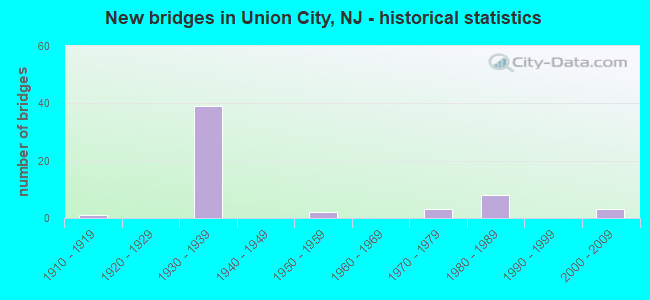
- New bridges - historical statistics
- 11910-1919
- 391930-1939
- 21950-1959
- 31970-1979
- 81980-1989
- 32000-2009

- Reconstructed bridges - Historical Statistics
- 11940-1949
- 11950-1959
- 01960-1969
- 01970-1979
- 11980-1989
- 11990-1999
- 22000-2009
- 12010-2019


- Bridge Condition - Deck
- 27.8%Good
- 61.1%Satisfactory
- 11.1%Fair

- Bridge Condition - Superstructure
- 3.7%Very good
- 14.8%Good
- 44.4%Satisfactory
- 37.0%Fair

- Bridge Condition - Substructure
- 7.4%Good
- 51.9%Satisfactory
- 40.7%Fair
Find on map >> Show street view
Structure Number: 900005, Location: 0.6 MI N OF RT 495 (Lat: 40.773039, Lng: -74.015531), Route carried "on" structure: County highway 505, Year Built: 1915, Status: Open, Structure Length: 1.55m (5.09ft), Average Daily Traffic: 13,681 (year 2021), Truck Traffic: 4%, Average Future Daily Traffic: 16,417 (year 2041), Features Intersected: CLIFF
Minimum Vertical Clearance: 30+ m (98+ ft), Kilometerpoint: 1.593, Lanes on structure: 2, Owner: County Highway Agency, Approaching Roadway Width: 15.2m (49.9ft), Skew: 1 degrees, Material/Design: Concrete, Design/Construction: Arch - Deck, Number Of Spans In Main Unit: 1, Length of Maximum Span: 15.5m (50.9ft), Curb or Sidewalk Widths: Left: 4.6m (15.1ft), Right: 3.7m (12.1ft), Curb-To-Curb Width: 15.2m (49.9ft), Out-to-Out Width: 24.0m (78.7ft)
Condition: Superstructure: Fair, Substructure: Fair, Operating Rating: 45.4 metric tons, Method Used To Determine Operating Rating: Field evaluation and documented engineering judgment, Inventory Rating: 27.2 metric tons, Method Used To Determine Inventory Rating: Field evaluation and documented engineering judgment, Structural Evaluation: Somewhat better than minimum adequacy, Deck Geometry: Superior to present desirable criteria, Approach Roadway Alignment: Better than present minimum criteria, Designated Inspection Frequency: Every 24 months, Inspection Date: Febuary 2021
Find on map >> Show street view
Structure Number: 900017, Location: 0.04 MI. N OF 14TH ST (Lat: 40.755619, Lng: -74.035339), Route carried "on" structure: City street CR683, Year Built: 1939, Year Reconstructed: 1993, Status: Open, Structure Length: 21.28m (69.82ft), Average Daily Traffic: 5,923 (year 2021), Truck Traffic: 4%, Average Future Daily Traffic: 7,107 (year 2041), Features Intersected: GORGE
Minimum Vertical Clearance: 30+ m (98+ ft), Kilometerpoint: 0.595, Lanes on structure: 2, Owner: County Highway Agency, Approaching Roadway Width: 11.0m (36.1ft), Material/Design: Steel, Design/Construction: Stringer/Multi-beam, Number Of Spans In Main Unit: 12, Length of Maximum Span: 18.0m (59.1ft), Curb or Sidewalk Widths: Left: 0.0m, Right: 2.4m (7.9ft), Curb-To-Curb Width: 11.0m (36.1ft), Out-to-Out Width: 14.2m (46.6ft)
Condition: Deck: Good, Superstructure: Good, Substructure: Satisfactory, Operating Rating: 64.4 metric tons, Method Used To Determine Operating Rating: Load Factor (LF), Inventory Rating: 38.1 metric tons, Method Used To Determine Inventory Rating: Load Factor (LF), Structural Evaluation: Equal to present minimum criteria, Deck Geometry: Meets minimum limits, Approach Roadway Alignment: Better than present minimum criteria, Designated Inspection Frequency: Every 24 months, Inspection Date: March 2021, Deck Structure Type: Concrete Cast-file-Place, Wearing Surface/Protective System: Wearing Surface: Monolithic Concrete, Deck Protection: Epoxy Coated Reinforcing
Find on map >> Show street view
Structure Number: 902152, Location: 0.10 MILES S. OF NJ 3 (Lat: 40.771531, Lng: -74.042589), Route carried "on" structure: US 1, Year Built: 2004, Status: Open, Structure Length: 3.57m (11.71ft), Average Daily Traffic: 70,700 (year 2020), Truck Traffic: 4%, Average Future Daily Traffic: 95,300 (year 2040), Design Load: HL 93, Features Intersected: AMTRAK
Minimum Vertical Clearance: 30+ m (98+ ft), Kilometerpoint: 92.006, Lanes on structure: 5, Base Highway Network: Yes, Owner: State Highway Agency, Approaching Roadway Width: 25.9m (85.0ft), Skew: 30 degrees, Material/Design: Steel, Design/Construction: Stringer/Multi-beam, Number Of Spans In Main Unit: 1, Length of Maximum Span: 34.1m (111.9ft), Curb or Sidewalk Widths: Left: 1.8m (5.9ft), Right: 1.8m (5.9ft), Curb-To-Curb Width: 25.8m (84.6ft), Out-to-Out Width: 30.8m (101.0ft)
Condition: Deck: Good, Superstructure: Very good, Substructure: Good, Operating Rating: 63.5 metric tons, Method Used To Determine Operating Rating: Load and Resistance Factor Rating (LRFR) rating reported by rating factor(RF) method using HL-93 loadings, Inventory Rating: 48.9 metric tons, Method Used To Determine Inventory Rating: Load and Resistance Factor Rating (LRFR) rating reported by rating factor(RF) method using HL-93 loadings, Structural Evaluation: Better than present minimum criteria, Deck Geometry: Superior to present desirable criteria, Underclear: High priority of corrective action, Approach Roadway Alignment: Superior to present desirable criteria, Length Of Structure Improvement: 3.57m (11.71ft), Designated Inspection Frequency: Every 24 months, Inspection Date: October 2020, Bridge Improvement Cost: $897,000, Roadway Improvement Cost: $179,000, Total Project Cost: $2,000,000 ( Estimate for 2020), Deck Structure Type: Concrete Cast-file-Place, Wearing Surface/Protective System: Wearing Surface: Bituminous, Deck Protection: Epoxy Coated Reinforcing
Find on map >> Show street view
Structure Number: 917152, Location: 1.4 MI W OF LINCOLN TUN (Lat: 40.773939, Lng: -74.035019), Route carried "on" structure: Ramp State highway 495, Year Built: 1938, Status: Open, Structure Length: 2.41m (7.91ft), Average Daily Traffic: 14,173 (year 2020), Truck Traffic: 5%, Average Future Daily Traffic: 17,008 (year 2040), Features Intersected: NJ 495, Facility Carried by Structure: RT 501 SB RAMP
Minimum Vertical Clearance: 30+ m (98+ ft), Kilometerpoint: 1.947, Lanes on structure: 1, Lanes under structure: 6, Owner: State Highway Agency, Approaching Roadway Width: 12.2m (40.0ft), Material/Design: Concrete, Design/Construction: Frame, Number Of Spans In Main Unit: 2, Length of Maximum Span: 11.0m (36.1ft), Curb or Sidewalk Widths: Left: 0.6m (2.0ft), Right: 1.5m (4.9ft), Curb-To-Curb Width: 12.2m (40.0ft), Out-to-Out Width: 19.0m (62.3ft)
Condition: Superstructure: Satisfactory, Substructure: Satisfactory, Structural Evaluation: Equal to present minimum criteria, Deck Geometry: Superior to present desirable criteria, Underclear: High priority of replacement, Approach Roadway Alignment: Equal to present minimum criteria, Length Of Structure Improvement: 3.78m (12.40ft), Designated Inspection Frequency: Every 24 months, Inspection Date: August 2020, Bridge Improvement Cost: $3,090,000, Roadway Improvement Cost: $464,000, Total Project Cost: $5,332,000 ( Estimate for 2020)
Find on map >> Show street view
Structure Number: 917153, Location: 1.4 MI W OF LINCOLN TUN (Lat: 40.774000, Lng: -74.034711), Route carried "on" structure: County highway 501, Year Built: 1987, Status: Open, Structure Length: 7.19m (23.59ft), Average Daily Traffic: 19,070 (year 2020), Truck Traffic: 4%, Average Future Daily Traffic: 22,884 (year 2040), Design Load: HS 20+Mod, Features Intersected: NJ495,N&S RAMPS
Minimum Vertical Clearance: 30+ m (98+ ft), Kilometerpoint: 54.782, Lanes on structure: 3, Lanes under structure: 8, Base Highway Network: Yes, Owner: State Highway Agency, Approaching Roadway Width: 8.2m (26.9ft), Skew: 10 degrees, Material/Design: Steel, Design/Construction: Stringer/Multi-beam, Number Of Spans In Main Unit: 3, Length of Maximum Span: 24.1m (79.1ft), Curb or Sidewalk Widths: Left: 4.1m (13.5ft), Right: 0.0m, Curb-To-Curb Width: 11.9m (39.0ft), Out-to-Out Width: 16.9m (55.4ft)
Condition: Deck: Good, Superstructure: Satisfactory, Substructure: Fair, Operating Rating: 49.9 metric tons, Method Used To Determine Operating Rating: Load Factor (LF), Inventory Rating: 29.9 metric tons, Method Used To Determine Inventory Rating: Load Factor (LF), Structural Evaluation: Somewhat better than minimum adequacy, Deck Geometry: High priority of corrective action, Underclear: High priority of replacement, Approach Roadway Alignment: Equal to present minimum criteria, Length Of Structure Improvement: 8.29m (27.20ft), Designated Inspection Frequency: Every 24 months, Critical Feature Inspection Frequency: Every 24 months, Inspection Date: August 2020, Critical Feature Inspection Date: August 2020, Bridge Improvement Cost: $6,354,000, Roadway Improvement Cost: $635,000, Total Project Cost: $11,297,000 ( Estimate for 2020), Deck Structure Type: Concrete Cast-file-Place, Wearing Surface/Protective System: Wearing Surface: Monolithic Concrete, Deck Protection: Epoxy Coated Reinforcing
Find on map >> Show street view
Structure Number: 917154, Location: 1.4 MI W OF LINCOLN TUN (Lat: 40.773389, Lng: -74.034661), Route carried "on" structure: County highway 501, Year Built: 1987, Status: Open, Structure Length: 7.19m (23.59ft), Average Daily Traffic: 19,070 (year 2020), Truck Traffic: 4%, Average Future Daily Traffic: 22,884 (year 2040), Design Load: HS 20+Mod, Features Intersected: NJ495,N&S RAMPS
Minimum Vertical Clearance: 30+ m (98+ ft), Kilometerpoint: 54.782, Lanes on structure: 3, Lanes under structure: 8, Base Highway Network: Yes, Owner: State Highway Agency, Approaching Roadway Width: 8.2m (26.9ft), Skew: 10 degrees, Material/Design: Steel, Design/Construction: Stringer/Multi-beam, Number Of Spans In Main Unit: 3, Length of Maximum Span: 24.1m (79.1ft), Curb or Sidewalk Widths: Left: 0.0m, Right: 4.1m (13.5ft), Curb-To-Curb Width: 11.9m (39.0ft), Out-to-Out Width: 16.9m (55.4ft)
Condition: Deck: Good, Superstructure: Satisfactory, Substructure: Fair, Operating Rating: 57.2 metric tons, Method Used To Determine Operating Rating: Load Factor (LF), Inventory Rating: 34.5 metric tons, Method Used To Determine Inventory Rating: Load Factor (LF), Structural Evaluation: Somewhat better than minimum adequacy, Deck Geometry: High priority of corrective action, Underclear: High priority of replacement, Approach Roadway Alignment: Equal to present minimum criteria, Length Of Structure Improvement: 8.29m (27.20ft), Designated Inspection Frequency: Every 24 months, Critical Feature Inspection Frequency: Every 24 months, Inspection Date: August 2020, Critical Feature Inspection Date: August 2020, Bridge Improvement Cost: $6,354,000, Roadway Improvement Cost: $635,000, Total Project Cost: $11,297,000 ( Estimate for 2020), Deck Structure Type: Concrete Cast-file-Place, Wearing Surface/Protective System: Wearing Surface: Monolithic Concrete, Deck Protection: Epoxy Coated Reinforcing
Find on map >> Show street view
Structure Number: 917155, Location: 1.2 MI WEST OF LIN TUNNEL (Lat: 40.773419, Lng: -74.034339), Route carried "on" structure: Ramp State highway 495, Year Built: 1938, Status: Open, Structure Length: 2.41m (7.91ft), Average Daily Traffic: 14,173 (year 2020), Truck Traffic: 5%, Average Future Daily Traffic: 17,008 (year 2040), Features Intersected: NJ 495, Facility Carried by Structure: RT 501 NB RAMP
Minimum Vertical Clearance: 30+ m (98+ ft), Kilometerpoint: 1.996, Lanes on structure: 1, Lanes under structure: 6, Owner: State Highway Agency, Approaching Roadway Width: 9.1m (29.9ft), Material/Design: Concrete, Design/Construction: Frame, Number Of Spans In Main Unit: 2, Length of Maximum Span: 11.0m (36.1ft), Curb or Sidewalk Widths: Left: 1.5m (4.9ft), Right: 0.6m (2.0ft), Curb-To-Curb Width: 12.2m (40.0ft), Out-to-Out Width: 19.0m (62.3ft)
Condition: Superstructure: Fair, Substructure: Fair, Operating Rating: 47.2 metric tons, Method Used To Determine Operating Rating: Load Factor (LF), Inventory Rating: 28.1 metric tons, Method Used To Determine Inventory Rating: Load Factor (LF), Structural Evaluation: Somewhat better than minimum adequacy, Deck Geometry: Superior to present desirable criteria, Underclear: High priority of replacement, Approach Roadway Alignment: Equal to present desirable criteria, Length Of Structure Improvement: 3.78m (12.40ft), Designated Inspection Frequency: Every 24 months, Inspection Date: August 2020, Bridge Improvement Cost: $3,090,000, Roadway Improvement Cost: $464,000, Total Project Cost: $5,332,000 ( Estimate for 2020)
Find on map >> Show street view
Structure Number: 917156, Location: 1.3 MI W OF LINCOLN TUN (Lat: 40.772689, Lng: -74.033131), Route carried "on" structure: City street , Year Built: 1938, Status: Open, Structure Length: 4.91m (16.11ft), Average Daily Traffic: 4,523 (year 2020), Truck Traffic: 1%, Average Future Daily Traffic: 5,427 (year 2040), Features Intersected: NJ 495, Facility Carried by Structure: SUMMIT AVE
Minimum Vertical Clearance: 30+ m (98+ ft), Kilometerpoint: 0.628, Lanes on structure: 2, Lanes under structure: 6, Owner: State Highway Agency, Approaching Roadway Width: 12.2m (40.0ft), Material/Design: Concrete continuous, Design/Construction: Frame, Number Of Spans In Main Unit: 2, Number Of Approach Spans: 2, Length of Maximum Span: 18.6m (61.0ft), Curb or Sidewalk Widths: Left: 2.8m (9.2ft), Right: 2.8m (9.2ft), Curb-To-Curb Width: 12.2m (40.0ft), Out-to-Out Width: 18.6m (61.0ft)
Condition: Superstructure: Fair, Substructure: Fair, Operating Rating: 79.8 metric tons, Method Used To Determine Operating Rating: Load Factor (LF), Inventory Rating: 48.1 metric tons, Method Used To Determine Inventory Rating: Load Factor (LF), Structural Evaluation: Somewhat better than minimum adequacy, Deck Geometry: Equal to present minimum criteria, Underclear: High priority of replacement, Approach Roadway Alignment: Equal to present desirable criteria, Length Of Structure Improvement: 5.88m (19.29ft), Designated Inspection Frequency: Every 24 months, Inspection Date: August 2020, Bridge Improvement Cost: $5,018,000, Roadway Improvement Cost: $530,000, Total Project Cost: $8,167,000 ( Estimate for 2020)
Find on map >> Show street view
Structure Number: 917157, Location: 1.3 MI W OF LIN TUNNEL (Lat: 40.772069, Lng: -74.031489), Route carried "on" structure: City street , Year Built: 1938, Status: Open, Structure Length: 2.41m (7.91ft), Average Daily Traffic: 7,517 (year 2020), Truck Traffic: 1%, Average Future Daily Traffic: 9,021 (year 2040), Features Intersected: NJ 495, Facility Carried by Structure: CENTRAL AVENUE
Minimum Vertical Clearance: 30+ m (98+ ft), Kilometerpoint: 0.000, Lanes on structure: 1, Lanes under structure: 6, Owner: State Highway Agency, Approaching Roadway Width: 9.1m (29.9ft), Material/Design: Concrete, Design/Construction: Frame, Number Of Spans In Main Unit: 2, Length of Maximum Span: 11.0m (36.1ft), Curb or Sidewalk Widths: Left: 2.7m (8.9ft), Right: 2.7m (8.9ft), Curb-To-Curb Width: 9.1m (29.9ft), Out-to-Out Width: 15.7m (51.5ft)
Condition: Superstructure: Fair, Substructure: Fair, Structural Evaluation: Somewhat better than minimum adequacy, Deck Geometry: High priority of corrective action, Underclear: High priority of replacement, Approach Roadway Alignment: Equal to present desirable criteria, Length Of Structure Improvement: 3.78m (12.40ft), Designated Inspection Frequency: Every 24 months, Inspection Date: August 2020, Bridge Improvement Cost: $2,579,000, Roadway Improvement Cost: $387,000, Total Project Cost: $4,500,000 ( Estimate for 2020)
Find on map >> Show street view
Structure Number: 917158, Location: 1 MI WEST LINCOLN TUNNEL (Lat: 40.771461, Lng: -74.029739), Route carried "on" structure: City street , Year Built: 1938, Status: Open, Structure Length: 2.41m (7.91ft), Average Daily Traffic: 6,566 (year 2020), Truck Traffic: 4%, Average Future Daily Traffic: 7,879 (year 2040), Features Intersected: NJ 495, Facility Carried by Structure: BERGENLINE AVE
Minimum Vertical Clearance: 30+ m (98+ ft), Kilometerpoint: 4.876, Lanes on structure: 2, Lanes under structure: 6, Owner: State Highway Agency, Approaching Roadway Width: 12.8m (42.0ft), Material/Design: Concrete, Design/Construction: Frame, Number Of Spans In Main Unit: 2, Length of Maximum Span: 11.0m (36.1ft), Curb or Sidewalk Widths: Left: 4.6m (15.1ft), Right: 4.3m (14.1ft), Curb-To-Curb Width: 7.3m (24.0ft), Out-to-Out Width: 24.8m (81.4ft)
Condition: Superstructure: Fair, Substructure: Fair, Operating Rating: 29.9 metric tons, Method Used To Determine Operating Rating: Field evaluation and documented engineering judgment, Inventory Rating: 17.2 metric tons, Method Used To Determine Inventory Rating: Field evaluation and documented engineering judgment, Structural Evaluation: Meets minimum limits, Deck Geometry: High priority of replacement, Underclear: High priority of replacement, Approach Roadway Alignment: Equal to present desirable criteria, Length Of Structure Improvement: 3.78m (12.40ft), Designated Inspection Frequency: Every 24 months, Inspection Date: August 2020, Bridge Improvement Cost: $4,042,000, Roadway Improvement Cost: $606,000, Total Project Cost: $6,974,000 ( Estimate for 2020)
Find on map >> Show street view
Structure Number: 917159, Location: 0.9 MI W OF LINCOLN TUN (Lat: 40.770819, Lng: -74.028861), Route carried "on" structure: City street , Year Built: 1938, Status: Open, Structure Length: 2.41m (7.91ft), Average Daily Traffic: 7,599 (year 2020), Truck Traffic: 4%, Average Future Daily Traffic: 9,119 (year 2040), Features Intersected: NJ 495, Facility Carried by Structure: NEW YORK AVENUE
Minimum Vertical Clearance: 30+ m (98+ ft), Kilometerpoint: 2.366, Lanes on structure: 2, Lanes under structure: 6, Owner: State Highway Agency, Approaching Roadway Width: 13.7m (44.9ft), Material/Design: Concrete, Design/Construction: Frame, Number Of Spans In Main Unit: 2, Length of Maximum Span: 11.0m (36.1ft), Curb or Sidewalk Widths: Left: 4.2m (13.8ft), Right: 4.3m (14.1ft), Curb-To-Curb Width: 13.7m (44.9ft), Out-to-Out Width: 23.3m (76.4ft)
Condition: Superstructure: Fair, Substructure: Satisfactory, Operating Rating: 29.9 metric tons, Method Used To Determine Operating Rating: Field evaluation and documented engineering judgment, Inventory Rating: 17.2 metric tons, Method Used To Determine Inventory Rating: Field evaluation and documented engineering judgment, Structural Evaluation: Meets minimum limits, Deck Geometry: Superior to present desirable criteria, Underclear: High priority of replacement, Approach Roadway Alignment: Equal to present desirable criteria, Length Of Structure Improvement: 3.78m (12.40ft), Designated Inspection Frequency: Every 24 months, Inspection Date: August 2020, Bridge Improvement Cost: $3,794,000, Roadway Improvement Cost: $569,000, Total Project Cost: $6,550,000 ( Estimate for 2020)
Find on map >> Show street view
Structure Number: 91716, Location: 1.1 MI W OF LINCOLN TUN (Lat: 40.770219, Lng: -74.027439), Route carried "on" structure: County highway 691, Year Built: 1938, Status: Open, Structure Length: 2.41m (7.91ft), Average Daily Traffic: 12,893 (year 2020), Truck Traffic: 3%, Average Future Daily Traffic: 15,471 (year 2040), Features Intersected: NJ 495, Facility Carried by Structure: PALISADE A &32NDST
Minimum Vertical Clearance: 30+ m (98+ ft), Kilometerpoint: 0.467, Lanes on structure: 4, Lanes under structure: 6, Owner: State Highway Agency, Approaching Roadway Width: 21.3m (69.9ft), Skew: 6 degrees, Material/Design: Concrete, Design/Construction: Frame, Number Of Spans In Main Unit: 2, Length of Maximum Span: 11.0m (36.1ft), Curb or Sidewalk Widths: Left: 2.7m (8.9ft), Right: 2.7m (8.9ft), Curb-To-Curb Width: 21.3m (69.9ft), Out-to-Out Width: 98.2m (322.2ft)
Condition: Superstructure: Fair, Substructure: Satisfactory, Operating Rating: 29.9 metric tons, Method Used To Determine Operating Rating: Field evaluation and documented engineering judgment, Inventory Rating: 17.2 metric tons, Method Used To Determine Inventory Rating: Field evaluation and documented engineering judgment, Structural Evaluation: Meets minimum limits, Deck Geometry: Superior to present desirable criteria, Underclear: High priority of replacement, Approach Roadway Alignment: Equal to present desirable criteria, Length Of Structure Improvement: 3.78m (12.40ft), Designated Inspection Frequency: Every 24 months, Inspection Date: August 2020, Bridge Improvement Cost: $15,981,000, Roadway Improvement Cost: $2,397,000, Total Project Cost: $27,600,000 ( Estimate for 2020)
Find on map >> Show street view
Structure Number: 917161, Location: 1.0 MI W OF LINCOLN TUN (Lat: 40.769861, Lng: -74.026469), Route carried "on" structure: City street , Year Built: 1938, Status: Open, Structure Length: 2.47m (8.10ft), Average Daily Traffic: 7,415 (year 2020), Truck Traffic: 1%, Average Future Daily Traffic: 8,898 (year 2040), Features Intersected: NJ 495, Facility Carried by Structure: HUDSON AVENUE
Minimum Vertical Clearance: 30+ m (98+ ft), Kilometerpoint: 0.000, Lanes on structure: 2, Lanes under structure: 6, Owner: State Highway Agency, Approaching Roadway Width: 9.1m (29.9ft), Material/Design: Concrete, Design/Construction: Frame, Number Of Spans In Main Unit: 2, Length of Maximum Span: 11.3m (37.1ft), Curb or Sidewalk Widths: Left: 2.7m (8.9ft), Right: 2.7m (8.9ft), Curb-To-Curb Width: 9.1m (29.9ft), Out-to-Out Width: 30.9m (101.4ft)
Condition: Superstructure: Fair, Substructure: Fair, Operating Rating: 29.9 metric tons, Method Used To Determine Operating Rating: Field evaluation and documented engineering judgment, Inventory Rating: 17.2 metric tons, Method Used To Determine Inventory Rating: Field evaluation and documented engineering judgment, Structural Evaluation: Meets minimum limits, Deck Geometry: Meets minimum limits, Underclear: High priority of replacement, Approach Roadway Alignment: Equal to present desirable criteria, Length Of Structure Improvement: 3.78m (12.40ft), Designated Inspection Frequency: Every 24 months, Inspection Date: August 2020, Bridge Improvement Cost: $5,024,000, Roadway Improvement Cost: $754,000, Total Project Cost: $8,670,000 ( Estimate for 2020)
Find on map >> Show street view
Structure Number: 917162, Location: 0.6 MI W OF LIN TUNNEL (Lat: 40.768439, Lng: -74.023700), Route carried "on" structure: State highway 495, Year Built: 1938, Year Reconstructed: 2012, Status: Open, Structure Length: 3.54m (11.61ft), Average Daily Traffic: 22,093 (year 2020), Truck Traffic: 1%, Average Future Daily Traffic: 26,512 (year 2040), Design Load: HL 93, Features Intersected: PARK AVENUE, Facility Carried by Structure: SOUTH MARGINAL ST
Minimum Vertical Clearance: 30+ m (98+ ft), Kilometerpoint: 3.074, Lanes on structure: 2, Lanes under structure: 2, Base Highway Network: Yes, Owner: State Highway Agency, Approaching Roadway Width: 9.1m (29.9ft), Skew: 3 degrees, Material/Design: Steel, Design/Construction: Girder and Floorbeam System, Number Of Spans In Main Unit: 1, Length of Maximum Span: 32.3m (106.0ft), Curb or Sidewalk Widths: Left: 0.7m (2.3ft), Right: 2.7m (8.9ft), Curb-To-Curb Width: 9.1m (29.9ft), Out-to-Out Width: 14.3m (46.9ft)
Condition: Deck: Satisfactory, Superstructure: Good, Substructure: Satisfactory, Operating Rating: 61.7 metric tons, Method Used To Determine Operating Rating: Load Factor (LF), Inventory Rating: 37.2 metric tons, Method Used To Determine Inventory Rating: Load Factor (LF), Structural Evaluation: Equal to present minimum criteria, Deck Geometry: High priority of replacement, Underclear: Equal to present minimum criteria, Approach Roadway Alignment: Equal to present minimum criteria, Length Of Structure Improvement: 3.54m (11.61ft), Designated Inspection Frequency: Every 24 months, Critical Feature Inspection Frequency: Every 24 months, Inspection Date: July 2020, Critical Feature Inspection Date: July 2020, Bridge Improvement Cost: $186,000, Roadway Improvement Cost: $21,000, Total Project Cost: $311,000 ( Estimate for 2020), Deck Structure Type: Concrete Cast-file-Place, Wearing Surface/Protective System: Wearing Surface: Bituminous
Find on map >> Show street view
Structure Number: 917163, Location: 0.6 MI W OF LIN TUNNEL (Lat: 40.768719, Lng: -74.023400), Route carried "on" structure: State highway 495, Year Built: 1938, Year Reconstructed: 2010, Status: Open, Structure Length: 4.08m (13.39ft), Average Daily Traffic: 32,915 (year 2020), Truck Traffic: 4%, Average Future Daily Traffic: 39,498 (year 2040), Features Intersected: PARK AVENUE, Facility Carried by Structure: NORTH MARGINAL ST
Minimum Vertical Clearance: 30+ m (98+ ft), Kilometerpoint: 3.074, Lanes on structure: 3, Lanes under structure: 2, Base Highway Network: Yes, Owner: State Highway Agency, Approaching Roadway Width: 9.1m (29.9ft), Skew: 4 degrees, Material/Design: Steel, Design/Construction: Girder and Floorbeam System, Number Of Spans In Main Unit: 1, Length of Maximum Span: 36.6m (120.1ft), Curb or Sidewalk Widths: Left: 0.7m (2.3ft), Right: 2.8m (9.2ft), Curb-To-Curb Width: 9.1m (29.9ft), Out-to-Out Width: 14.0m (45.9ft)
Condition: Deck: Satisfactory, Superstructure: Fair, Substructure: Fair, Operating Rating: 46.3 metric tons, Method Used To Determine Operating Rating: Load Factor (LF), Inventory Rating: 27.2 metric tons, Method Used To Determine Inventory Rating: Load Factor (LF), Structural Evaluation: Somewhat better than minimum adequacy, Deck Geometry: High priority of replacement, Underclear: Meets minimum limits, Approach Roadway Alignment: Equal to present minimum criteria, Length Of Structure Improvement: 4.08m (13.39ft), Designated Inspection Frequency: Every 24 months, Critical Feature Inspection Frequency: Every 24 months, Inspection Date: July 2020, Critical Feature Inspection Date: July 2020, Bridge Improvement Cost: $214,000, Roadway Improvement Cost: $22,000, Total Project Cost: $345,000 ( Estimate for 2020), Deck Structure Type: Concrete Cast-file-Place, Wearing Surface/Protective System: Deck Protection: Epoxy Coated Reinforcing
Find on map >> Show street view
Structure Number: 917164, Location: Inters Park & S. Marginal (Lat: 40.768250, Lng: -74.023331), Route carried "on" structure: ServiceState highway 495, Year Built: 1938, Year Reconstructed: 2012, Status: Open, Structure Length: 2.59m (8.50ft), Average Daily Traffic: 36,701 (year 2021), Truck Traffic: 3%, Average Future Daily Traffic: 44,041 (year 2041), Features Intersected: Relief Cut, Facility Carried by Structure: S. Marginal Hwy
Minimum Vertical Clearance: 30+ m (98+ ft), Kilometerpoint: 0.177, Lanes on structure: 2, Owner: State Highway Agency, Approaching Roadway Width: 9.1m (29.9ft), Skew: 9 degrees, Material/Design: Concrete continuous, Design/Construction: Tee Beam, Number Of Spans In Main Unit: 4, Length of Maximum Span: 7.9m (25.9ft), Curb or Sidewalk Widths: Left: 0.8m (2.6ft), Right: 3.0m (9.8ft), Curb-To-Curb Width: 9.1m (29.9ft), Out-to-Out Width: 13.1m (43.0ft)
Condition: Deck: Satisfactory, Superstructure: Fair, Substructure: Satisfactory, Operating Rating: 34.5 metric tons, Method Used To Determine Operating Rating: Load Factor (LF), Inventory Rating: 20.0 metric tons, Method Used To Determine Inventory Rating: Load Factor (LF), Structural Evaluation: Somewhat better than minimum adequacy, Deck Geometry: Meets minimum limits, Approach Roadway Alignment: Equal to present desirable criteria, Length Of Structure Improvement: 2.59m (8.50ft), Designated Inspection Frequency: Every 24 months, Inspection Date: April 2021, Bridge Improvement Cost: $109,000, Roadway Improvement Cost: $250,000, Total Project Cost: $449,000 ( Estimate for 2021), Deck Structure Type: Concrete Cast-file-Place, Wearing Surface/Protective System: Wearing Surface: Latex Concrete
Find on map >> Show street view
Structure Number: 953163, Location: 0.45 MI N of Lincoln Tunn (Lat: 40.773331, Lng: -74.015000), Route carried "on" structure: City street , Year Built: 2004, Status: Open, Structure Length: 7.16m (23.49ft), Average Daily Traffic: 2,560 (year 2020), Truck Traffic: 3%, Average Future Daily Traffic: 3,120 (year 2040), Features Intersected: HBLR&Port Imperial, Facility Carried by Structure: Pershing Road
Minimum Vertical Clearance: 30+ m (98+ ft), Kilometerpoint: 0.595, Lanes on structure: 2, Lanes under structure: 4, Maintenance Responsibility: State Highway Agency, Approaching Roadway Width: 10.1m (33.1ft), Material/Design: Steel, Design/Construction: Stringer/Multi-beam, Number Of Spans In Main Unit: 6, Length of Maximum Span: 18.6m (61.0ft), Curb or Sidewalk Widths: Left: 0.0m, Right: 1.9m (6.2ft), Curb-To-Curb Width: 9.9m (32.5ft), Out-to-Out Width: 13.1m (43.0ft)
Condition: Deck: Good, Superstructure: Good, Substructure: Satisfactory, Inventory Rating: 60.8 metric tons, Method Used To Determine Inventory Rating: Load Factor (LF), Structural Evaluation: Equal to present minimum criteria, Deck Geometry: Meets minimum limits, Underclear: High priority of replacement, Approach Roadway Alignment: High priority of corrective action, Length Of Structure Improvement: 7.16m (23.49ft), Designated Inspection Frequency: Every 24 months, Inspection Date: July 2020, Bridge Improvement Cost: $4,319,000, Roadway Improvement Cost: $159,000, Total Project Cost: $8,456,000 ( Estimate for 2020), Deck Structure Type: Concrete Cast-file-Place, Wearing Surface/Protective System: Wearing Surface: Monolithic Concrete, Deck Protection: Epoxy Coated Reinforcing
Find on map >> Show street view
Structure Number: 361431A, Location: AT GSP & RT 78 JUNCTION (Lat: 40.709269, Lng: -74.246350), Route carried "on" structure: Ramp Other road GSP, Year Built: 1974, Status: Open, Structure Length: 4.60m (15.09ft), Average Daily Traffic: 18,362 (year 2021), Truck Traffic: 1%, Average Future Daily Traffic: 28,675 (year 2041), Design Load: H 20, Features Intersected: ELIZABETH RIVER
Minimum Vertical Clearance: 30+ m (98+ ft), Kilometerpoint: 230.297, Lanes on structure: 2, Toll: On toll road, Owner: State Toll Authority, Approaching Roadway Width: 8.5m (27.9ft), Skew: 3 degrees, Material/Design: Prestressed concrete, Design/Construction: Stringer/Multi-beam, Number Of Spans In Main Unit: 3, Length of Maximum Span: 15.2m (49.9ft), Curb-To-Curb Width: 8.4m (27.6ft), Out-to-Out Width: 10.2m (33.5ft)
Condition: Deck: Satisfactory, Superstructure: Satisfactory, Substructure: Good, Channel: Satisfactory, Operating Rating: 46.7 metric tons, Method Used To Determine Operating Rating: Load and Resistance Factor Rating (LRFR) rating reported by rating factor(RF) method using HL-93 loadings, Inventory Rating: 18.8 metric tons, Method Used To Determine Inventory Rating: Load and Resistance Factor Rating (LRFR) rating reported by rating factor(RF) method using HL-93 loadings, Structural Evaluation: Meets minimum limits, Deck Geometry: High priority of corrective action, Waterway Adequacy: Equal to present desirable criteria, Approach Roadway Alignment: Equal to present minimum criteria, Length Of Structure Improvement: 4.60m (15.09ft), Designated Inspection Frequency: Every 24 months, Inspection Date: August 2021, Bridge Improvement Cost: $100,000, Roadway Improvement Cost: $7,000, Total Project Cost: $134,000 ( Estimate for 2015), Deck Structure Type: Concrete Cast-file-Place, Wearing Surface/Protective System: Wearing Surface: Bituminous, Membrane: Preformed Fabric
Find on map >> Show street view
Structure Number: 361431C, Location: AT GSP INTERCHANGE NO.142 (Lat: 40.705961, Lng: -74.251500), Route carried "on" structure: Ramp Other road GSP, Year Built: 1974, Year Reconstructed: 1997, Status: Open, Structure Length: 7.56m (24.80ft), Average Daily Traffic: 16,136 (year 2021), Truck Traffic: 1%, Average Future Daily Traffic: 19,689 (year 2041), Design Load: HS 20+Mod, Features Intersected: RTE I-78
Minimum Vertical Clearance: 30+ m (98+ ft), Kilometerpoint: 230.297, Lanes on structure: 2, Lanes under structure: 11, Toll: On toll road, Owner: State Toll Authority, Approaching Roadway Width: 9.1m (29.9ft), Material/Design: Steel, Design/Construction: Stringer/Multi-beam, Number Of Spans In Main Unit: 2, Length of Maximum Span: 36.9m (121.1ft), Curb-To-Curb Width: 9.1m (29.9ft), Out-to-Out Width: 10.2m (33.5ft)
Condition: Deck: Satisfactory, Superstructure: Good, Substructure: Satisfactory, Operating Rating: 48.9 metric tons, Method Used To Determine Operating Rating: Load and Resistance Factor Rating (LRFR) rating reported by rating factor(RF) method using HL-93 loadings, Inventory Rating: 37.6 metric tons, Method Used To Determine Inventory Rating: Load and Resistance Factor Rating (LRFR) rating reported by rating factor(RF) method using HL-93 loadings, Structural Evaluation: Equal to present minimum criteria, Deck Geometry: Meets minimum limits, Underclear: High priority of corrective action, Approach Roadway Alignment: Equal to present minimum criteria, Length Of Structure Improvement: 7.56m (24.80ft), Designated Inspection Frequency: Every 24 months, Inspection Date: August 2021, Bridge Improvement Cost: $212,000, Roadway Improvement Cost: $424,000, Total Project Cost: $636,000 ( Estimate for 2015), Deck Structure Type: Concrete Cast-file-Place, Wearing Surface/Protective System: Wearing Surface: Bituminous, Membrane: Preformed Fabric
Find on map >> Show street view
Structure Number: 3800019, Location: .4 MI WEST LINCOLN TUNNEL (Lat: 40.768969, Lng: -74.024469), Route carried "on" structure: State highway NJ495, Year Built: 1937, Status: Open, Structure Length: 2.13m (6.99ft), Average Daily Traffic: 141,364 (year 2021), Truck Traffic: 5%, Average Future Daily Traffic: 172,464 (year 2041), Design Load: H 20, Features Intersected: PLEASANT AVENUE, Facility Carried by Structure: NJ-495
Minimum Vertical Clearance: 30+ m (98+ ft), Kilometerpoint: 3.347, Lanes on structure: 6, Lanes under structure: 4, Base Highway Network: Yes, Owner: State Agenciy, Approaching Roadway Width: 19.5m (64.0ft), Skew: 30 degrees, Material/Design: Steel, Design/Construction: Stringer/Multi-beam, Number Of Spans In Main Unit: 1, Length of Maximum Span: 19.8m (65.0ft), Curb or Sidewalk Widths: Left: 0.5m (1.6ft), Right: 0.5m (1.6ft), Curb-To-Curb Width: 19.5m (64.0ft), Out-to-Out Width: 22.2m (72.8ft)
Condition: Deck: Satisfactory, Superstructure: Satisfactory, Substructure: Satisfactory, Operating Rating: 76.2 metric tons, Method Used To Determine Operating Rating: Load Factor (LF), Inventory Rating: 45.4 metric tons, Method Used To Determine Inventory Rating: Load Factor (LF), Structural Evaluation: Equal to present minimum criteria, Deck Geometry: High priority of replacement, Underclear: High priority of replacement, Approach Roadway Alignment: Equal to present desirable criteria, Length Of Structure Improvement: 2.83m (9.28ft), Designated Inspection Frequency: Every 24 months, Inspection Date: May 2021, Bridge Improvement Cost: $2,879,000, Roadway Improvement Cost: $288,000, Total Project Cost: $5,800,000 ( Estimate for 2015), Deck Structure Type: Concrete Cast-file-Place, Wearing Surface/Protective System: Wearing Surface: Bituminous
Find on map >> Show street view
Structure Number: 3800021, Location: NJ PLAZA,LINCOLN TUNNEL (Lat: 40.768361, Lng: -74.023300), Route carried "on" structure: Ramp State highway NJ495, Year Built: 1938, Status: Open, Structure Length: 13.05m (42.81ft), Average Daily Traffic: 27 (year 2021), Truck Traffic: 1%, Average Future Daily Traffic: 32 (year 2041), Design Load: H 20, Features Intersected: PARK AVENUE, Facility Carried by Structure: SOUTH RAMP(NJ-495)
Minimum Vertical Clearance: 30+ m (98+ ft), Kilometerpoint: 3.446, Lanes on structure: 1, Lanes under structure: 2, Base Highway Network: Yes, Owner: State Agenciy, Approaching Roadway Width: 6.7m (22.0ft), Material/Design: Steel, Design/Construction: Girder and Floorbeam System, Number Of Spans In Main Unit: 1, Number Of Approach Spans: 13, Length of Maximum Span: 32.6m (107.0ft), Curb or Sidewalk Widths: Left: 1.2m (3.9ft), Right: 0.9m (3.0ft), Curb-To-Curb Width: 6.7m (22.0ft), Out-to-Out Width: 9.5m (31.2ft)
Condition: Deck: Satisfactory, Superstructure: Satisfactory, Substructure: Satisfactory, Operating Rating: 35.4 metric tons, Method Used To Determine Operating Rating: Load Factor (LF), Inventory Rating: 16.3 metric tons, Method Used To Determine Inventory Rating: Load Factor (LF), Structural Evaluation: Meets minimum limits, Deck Geometry: Equal to present minimum criteria, Underclear: Equal to present minimum criteria, Approach Roadway Alignment: Equal to present desirable criteria, Designated Inspection Frequency: Every 24 months, Critical Feature Inspection Frequency: Every 24 months, Inspection Date: May 2021, Critical Feature Inspection Date: May 2021, Deck Structure Type: Concrete Cast-file-Place, Wearing Surface/Protective System: Wearing Surface: Bituminous
Find on map >> Show street view
Structure Number: 3800024, Location: NJ PLAZA,LINCOLN TUNNEL (Lat: 40.768631, Lng: -74.023689), Route carried "on" structure: State highway 495, Year Built: 1938, Status: Open, Structure Length: 3.78m (12.40ft), Average Daily Traffic: 141,363 (year 2021), Truck Traffic: 5%, Average Future Daily Traffic: 172,463 (year 2041), Design Load: H 20, Features Intersected: PARK AVENUE
Minimum Vertical Clearance: 30+ m (98+ ft), Kilometerpoint: 3.421, Lanes on structure: 6, Lanes under structure: 2, Base Highway Network: Yes, Owner: State Agenciy, Approaching Roadway Width: 19.5m (64.0ft), Skew: 34 degrees, Material/Design: Steel, Design/Construction: Girder and Floorbeam System, Number Of Spans In Main Unit: 1, Length of Maximum Span: 36.6m (120.1ft), Curb or Sidewalk Widths: Left: 0.5m (1.6ft), Right: 0.5m (1.6ft), Curb-To-Curb Width: 19.5m (64.0ft), Out-to-Out Width: 22.7m (74.5ft)
Condition: Deck: Satisfactory, Superstructure: Satisfactory, Substructure: Satisfactory, Operating Rating: 69.9 metric tons, Method Used To Determine Operating Rating: Load Factor (LF), Inventory Rating: 41.7 metric tons, Method Used To Determine Inventory Rating: Load Factor (LF), Structural Evaluation: Equal to present minimum criteria, Deck Geometry: High priority of replacement, Underclear: High priority of replacement, Approach Roadway Alignment: Equal to present desirable criteria, Length Of Structure Improvement: 3.81m (12.50ft), Designated Inspection Frequency: Every 24 months, Inspection Date: May 2021, Bridge Improvement Cost: $3,870,000, Roadway Improvement Cost: $387,000, Total Project Cost: $7,800,000 ( Estimate for 2015), Deck Structure Type: Concrete Cast-file-Place, Wearing Surface/Protective System: Wearing Surface: Bituminous
Find on map >> Show street view
Structure Number: 3800026, Location: NJ PLAZA,LINCOLN TUNNEL (Lat: 40.768500, Lng: -74.023311), Route carried "on" structure: State highway NJ495, Year Built: 1937, Status: Open, Structure Length: 11.58m (37.99ft), Average Daily Traffic: 141,363 (year 2021), Truck Traffic: 5%, Average Future Daily Traffic: 172,463 (year 2041), Design Load: H 20, Features Intersected: NONE, Facility Carried by Structure: NJ-495
Minimum Vertical Clearance: 30+ m (98+ ft), Kilometerpoint: 3.458, Lanes on structure: 6, Base Highway Network: Yes, Owner: State Agenciy, Approaching Roadway Width: 19.5m (64.0ft), Skew: 30 degrees, Material/Design: Concrete, Design/Construction: Tee Beam, Number Of Spans In Main Unit: 14, Length of Maximum Span: 8.5m (27.9ft), Curb or Sidewalk Widths: Left: 0.5m (1.6ft), Right: 0.4m (1.3ft), Curb-To-Curb Width: 19.5m (64.0ft), Out-to-Out Width: 22.5m (73.8ft)
Condition: Deck: Satisfactory, Superstructure: Satisfactory, Substructure: Fair, Operating Rating: 32.7 metric tons, Method Used To Determine Operating Rating: Load Factor (LF), Inventory Rating: 19.1 metric tons, Method Used To Determine Inventory Rating: Load Factor (LF), Structural Evaluation: Meets minimum limits, Deck Geometry: High priority of replacement, Approach Roadway Alignment: Equal to present desirable criteria, Length Of Structure Improvement: 12.74m (41.80ft), Designated Inspection Frequency: Every 24 months, Inspection Date: May 2021, Bridge Improvement Cost: $12,941,000, Roadway Improvement Cost: $1,294,000, Total Project Cost: $26,100,000 ( Estimate for 2015), Deck Structure Type: Concrete Cast-file-Place, Wearing Surface/Protective System: Wearing Surface: Bituminous
Find on map >> Show street view
Structure Number: 3800027, Location: LINCOLN TUNNEL HELIX (Lat: 40.767931, Lng: -74.022311), Route carried "on" structure: State highway NJ495, Year Built: 1937, Year Reconstructed: 1955, Status: Open, Structure Length: 13.69m (44.91ft), Average Daily Traffic: 141,163 (year 2021), Truck Traffic: 5%, Average Future Daily Traffic: 172,219 (year 2041), Design Load: H 20, Features Intersected: JFK BLVD E, N&S MARGINAL, Facility Carried by Structure: NJ-495
Minimum Vertical Clearance: 30+ m (98+ ft), Kilometerpoint: 3.576, Lanes on structure: 7, Lanes under structure: 10, Owner: State Agenciy, Approaching Roadway Width: 26.2m (86.0ft), Skew: 39 degrees, Material/Design: Steel, Design/Construction: Girder and Floorbeam System, Number Of Spans In Main Unit: 5, Number Of Approach Spans: 1, Length of Maximum Span: 43.6m (143.0ft), Curb or Sidewalk Widths: Left: 0.5m (1.6ft), Right: 0.5m (1.6ft), Curb-To-Curb Width: 26.2m (86.0ft), Out-to-Out Width: 39.8m (130.6ft)
Condition: Deck: Fair, Superstructure: Satisfactory, Substructure: Satisfactory, Operating Rating: 49.9 metric tons, Method Used To Determine Operating Rating: Load Factor (LF), Inventory Rating: 29.9 metric tons, Method Used To Determine Inventory Rating: Load Factor (LF), Structural Evaluation: Equal to present minimum criteria, Deck Geometry: Meets minimum limits, Underclear: High priority of replacement, Approach Roadway Alignment: Somewhat better than minimum adequacy, Length Of Structure Improvement: 14.63m (48.00ft), Designated Inspection Frequency: Every 24 months, Critical Feature Inspection Frequency: Every 24 months, Inspection Date: May 2021, Critical Feature Inspection Date: May 2021, Bridge Improvement Cost: $22,637,000, Roadway Improvement Cost: $2,264,000, Total Project Cost: $45,600,000 ( Estimate for 2015), Deck Structure Type: Concrete Cast-file-Place, Wearing Surface/Protective System: Wearing Surface: Bituminous
Find on map >> Show street view
Structure Number: 3800028, Location: NJ PLAZA LINCOLN TUNNEL (Lat: 40.768411, Lng: -74.022250), Route carried "on" structure: Ramp State highway NJ495, Year Built: 1937, Status: Open, Structure Length: 2.10m (6.89ft), Average Daily Traffic: 11,694 (year 2021), Truck Traffic: 5%, Average Future Daily Traffic: 14,267 (year 2041), Design Load: H 20, Features Intersected: NORTH MARGINAL STREET
Minimum Vertical Clearance: 30+ m (98+ ft), Kilometerpoint: 3.573, Lanes on structure: 1, Lanes under structure: 2, Owner: State Agenciy, Approaching Roadway Width: 6.7m (22.0ft), Skew: 9 degrees, Material/Design: Steel, Design/Construction: Girder and Floorbeam System, Number Of Spans In Main Unit: 2, Length of Maximum Span: 10.4m (34.1ft), Curb or Sidewalk Widths: Left: 0.4m (1.3ft), Right: 0.5m (1.6ft), Curb-To-Curb Width: 6.8m (22.3ft), Out-to-Out Width: 8.8m (28.9ft)
Condition: Deck: Satisfactory, Superstructure: Satisfactory, Substructure: Satisfactory, Operating Rating: 49.9 metric tons, Method Used To Determine Operating Rating: Load Factor (LF), Inventory Rating: 29.9 metric tons, Method Used To Determine Inventory Rating: Load Factor (LF), Structural Evaluation: Equal to present minimum criteria, Deck Geometry: Equal to present minimum criteria, Underclear: Equal to present desirable criteria, Approach Roadway Alignment: Equal to present minimum criteria, Designated Inspection Frequency: Every 24 months, Critical Feature Inspection Frequency: Every 24 months, Inspection Date: May 2021, Critical Feature Inspection Date: May 2021, Deck Structure Type: Concrete Cast-file-Place, Wearing Surface/Protective System: Wearing Surface: Bituminous
Find on map >> Show street view
Structure Number: 3800029, Location: NEAR LINCOLN TUNNEL PLAZA (Lat: 40.763569, Lng: -74.024900), Route carried "on" structure: State highway NJ495, Year Built: 1954, Status: Open, Structure Length: 1.52m (4.99ft), Average Daily Traffic: 90,276 (year 2021), Truck Traffic: 5%, Average Future Daily Traffic: 110,137 (year 2041), Design Load: H 20, Features Intersected: CENTER RAMP TO LIN TUNNL, Facility Carried by Structure: NJ-495 WB
Minimum Vertical Clearance: 30+ m (98+ ft), Kilometerpoint: 4.104, Lanes on structure: 4, Lanes under structure: 2, Base Highway Network: Yes, Owner: State Agenciy, Approaching Roadway Width: 14.5m (47.6ft), Skew: 4 degrees, Material/Design: Steel, Design/Construction: Stringer/Multi-beam, Number Of Spans In Main Unit: 1, Length of Maximum Span: 15.2m (49.9ft), Curb or Sidewalk Widths: Left: 0.0m, Right: 0.7m (2.3ft), Curb-To-Curb Width: 14.5m (47.6ft), Out-to-Out Width: 16.5m (54.1ft)
Condition: Deck: Satisfactory, Superstructure: Satisfactory, Substructure: Fair, Operating Rating: 45.4 metric tons, Method Used To Determine Operating Rating: Load Factor (LF), Inventory Rating: 26.3 metric tons, Method Used To Determine Inventory Rating: Load Factor (LF), Structural Evaluation: Somewhat better than minimum adequacy, Deck Geometry: High priority of replacement, Underclear: High priority of replacement, Approach Roadway Alignment: Equal to present desirable criteria, Length Of Structure Improvement: 2.23m (7.32ft), Designated Inspection Frequency: Every 24 months, Inspection Date: May 2021, Bridge Improvement Cost: $1,630,000, Roadway Improvement Cost: $163,000, Total Project Cost: $3,300,000 ( Estimate for 2015), Deck Structure Type: Concrete Cast-file-Place, Wearing Surface/Protective System: Wearing Surface: Bituminous
Find on map >> Show street view
Structure Number: 3800031, Location: NEAR LINCOLN TUNNEL PLAZA (Lat: 40.763131, Lng: -74.024339), Route carried "on" structure: State highway NJ495, Year Built: 1937, Year Reconstructed: 1954, Status: Open, Structure Length: 38.95m (127.79ft), Average Daily Traffic: 141,363 (year 2021), Truck Traffic: 5%, Average Future Daily Traffic: 172,463 (year 2041), Design Load: H 20, Features Intersected: HUDS-BERG LT RL&BALDW AV, Facility Carried by Structure: NJ-495
Minimum Vertical Clearance: 30+ m (98+ ft), Kilometerpoint: 3.830, Lanes on structure: 7, Lanes under structure: 3, Base Highway Network: Yes, Owner: State Agenciy, Approaching Roadway Width: 23.2m (76.1ft), Skew: 39 degrees, Material/Design: Steel, Design/Construction: Truss - Deck, Number Of Spans In Main Unit: 4, Number Of Approach Spans: 20, Length of Maximum Span: 46.3m (151.9ft), Curb or Sidewalk Widths: Left: 0.5m (1.6ft), Right: 0.5m (1.6ft), Curb-To-Curb Width: 23.2m (76.1ft), Out-to-Out Width: 26.3m (86.3ft)
Condition: Deck: Fair, Superstructure: Satisfactory, Substructure: Satisfactory, Operating Rating: 32.7 metric tons, Method Used To Determine Operating Rating: Load Factor (LF), Inventory Rating: 19.1 metric tons, Method Used To Determine Inventory Rating: Load Factor (LF), Structural Evaluation: Meets minimum limits, Deck Geometry: High priority of replacement, Underclear: Meets minimum limits, Approach Roadway Alignment: Equal to present desirable criteria, Length Of Structure Improvement: 56.48m (185.30ft), Designated Inspection Frequency: Every 24 months, Critical Feature Inspection Frequency: Every 24 months, Inspection Date: May 2021, Critical Feature Inspection Date: May 2021, Bridge Improvement Cost: $65,374,000, Roadway Improvement Cost: $6,537,000, Total Project Cost: $132,000,000 ( Estimate for 2015), Deck Structure Type: Concrete Cast-file-Place, Wearing Surface/Protective System: Wearing Surface: Latex Concrete
Find on map >> Show street view
Structure Number: 917152, Location: 1.4 MI W OF LINCOLN TUN (Lat: 40.773939, Lng: -74.035019), Route carried "under" structure: State highway 495, Year Built: 1938, Structure Length: 0. m, Average Daily Traffic: 147,926 (year 2020), Truck Traffic: 5%, Features Intersected: NJ 495, Facility Carried by Structure: RT 501 SB RAMP
Minimum Vertical Clearance: 5.13m (16.83ft), Kilometerpoint: 1.947, Lanes on structure: 1, Lanes under structure: 6, Material/Design: Concrete, Design/Construction: Frame, Length of Maximum Span: 11.0m (36.1ft)
Find on map >> Show street view
Structure Number: 917153, Location: 1.4 MI W OF LINCOLN TUN (Lat: 40.774000, Lng: -74.034711), Route carried "under" structure: Ramp State highway 495, Year Built: 1987, Structure Length: 0. m, Average Daily Traffic: 14,173 (year 2020), Truck Traffic: 5%, Features Intersected: NJ495,N&S RAMPS, Facility Carried by Structure: RT501(JFK BLVD)SB
Minimum Vertical Clearance: 5.11m (16.77ft), Kilometerpoint: 1.979, Lanes on structure: 3, Lanes under structure: 1, Material/Design: Steel, Design/Construction: Stringer/Multi-beam, Length of Maximum Span: 24.1m (79.1ft)
Find on map >> Show street view
Structure Number: 917153, Location: 1.4 MI W OF LINCOLN TUN (Lat: 40.774000, Lng: -74.034711), Route carried "under" structure: Ramp State highway 495, Year Built: 1987, Structure Length: 0. m, Average Daily Traffic: 14,173 (year 2020), Truck Traffic: 5%, Features Intersected: NJ495,N&S RAMPS, Facility Carried by Structure: RT501(JFK BLVD)SB
Minimum Vertical Clearance: 4.98m (16.34ft), Kilometerpoint: 1.979, Lanes on structure: 3, Lanes under structure: 1, Material/Design: Steel, Design/Construction: Stringer/Multi-beam, Length of Maximum Span: 24.1m (79.1ft)
Find on map >> Show street view
Structure Number: 917153, Location: 1.4 MI W OF LINCOLN TUN (Lat: 40.774000, Lng: -74.034711), Route carried "under" structure: State highway 495, Year Built: 1987, Structure Length: 0. m, Average Daily Traffic: 147,925 (year 2020), Truck Traffic: 5%, Features Intersected: NJ495,N&S RAMPS, Facility Carried by Structure: RT501(JFK BLVD)SB
Minimum Vertical Clearance: 11.45m (37.57ft), Kilometerpoint: 1.979, Lanes on structure: 3, Lanes under structure: 6, Material/Design: Steel, Design/Construction: Stringer/Multi-beam, Length of Maximum Span: 24.1m (79.1ft)
Find on map >> Show street view
Structure Number: 917154, Location: 1.4 MI W OF LINCOLN TUN (Lat: 40.773389, Lng: -74.034661), Route carried "under" structure: State highway 495, Year Built: 1987, Structure Length: 0. m, Average Daily Traffic: 147,925 (year 2020), Truck Traffic: 5%, Features Intersected: NJ495,N&S RAMPS, Facility Carried by Structure: RT501(JFK BLVD) NB
Minimum Vertical Clearance: 10.36m (33.99ft), Kilometerpoint: 1.979, Lanes on structure: 3, Lanes under structure: 6, Material/Design: Steel, Design/Construction: Stringer/Multi-beam, Length of Maximum Span: 24.1m (79.1ft)
Find on map >> Show street view
Structure Number: 917154, Location: 1.4 MI W OF LINCOLN TUN (Lat: 40.773389, Lng: -74.034661), Route carried "under" structure: Ramp State highway 495, Year Built: 1987, Structure Length: 0. m, Average Daily Traffic: 14,173 (year 2020), Truck Traffic: 5%, Features Intersected: NJ495,N&S RAMPS, Facility Carried by Structure: RT501(JFK BLVD) NB
Minimum Vertical Clearance: 4.70m (15.42ft), Kilometerpoint: 1.979, Lanes on structure: 3, Lanes under structure: 1, Material/Design: Steel, Design/Construction: Stringer/Multi-beam, Length of Maximum Span: 24.1m (79.1ft)
Find on map >> Show street view
Structure Number: 917154, Location: 1.4 MI W OF LINCOLN TUN (Lat: 40.773389, Lng: -74.034661), Route carried "under" structure: Ramp State highway 495, Year Built: 1987, Structure Length: 0. m, Average Daily Traffic: 14,173 (year 2020), Truck Traffic: 5%, Features Intersected: NJ495,N&S RAMPS, Facility Carried by Structure: RT501(JFK BLVD) NB
Minimum Vertical Clearance: 4.85m (15.91ft), Kilometerpoint: 1.979, Lanes on structure: 3, Lanes under structure: 1, Material/Design: Steel, Design/Construction: Stringer/Multi-beam, Length of Maximum Span: 24.1m (79.1ft)
Find on map >> Show street view
Structure Number: 917155, Location: 1.2 MI WEST OF LIN TUNNEL (Lat: 40.773419, Lng: -74.034339), Route carried "under" structure: State highway 495, Year Built: 1938, Structure Length: 0. m, Average Daily Traffic: 147,926 (year 2020), Truck Traffic: 5%, Features Intersected: NJ 495, Facility Carried by Structure: RT 501 NB RAMP
Minimum Vertical Clearance: 4.50m (14.76ft), Kilometerpoint: 1.996, Lanes on structure: 1, Lanes under structure: 6, Material/Design: Concrete, Design/Construction: Frame, Length of Maximum Span: 11.0m (36.1ft)
Find on map >> Show street view
Structure Number: 917156, Location: 1.3 MI W OF LINCOLN TUN (Lat: 40.772689, Lng: -74.033131), Route carried "under" structure: State highway 495, Year Built: 1938, Structure Length: 0. m, Average Daily Traffic: 147,926 (year 2020), Truck Traffic: 5%, Features Intersected: NJ 495, Facility Carried by Structure: SUMMIT AVE
Minimum Vertical Clearance: 5.56m (18.24ft), Kilometerpoint: 2.140, Lanes on structure: 2, Lanes under structure: 6, Material/Design: Concrete continuous, Design/Construction: Frame, Length of Maximum Span: 18.6m (61.0ft)
Find on map >> Show street view
Structure Number: 917157, Location: 1.3 MI W OF LIN TUNNEL (Lat: 40.772069, Lng: -74.031489), Route carried "under" structure: State highway 495, Year Built: 1938, Structure Length: 0. m, Average Daily Traffic: 147,926 (year 2020), Truck Traffic: 5%, Features Intersected: NJ 495, Facility Carried by Structure: CENTRAL AVENUE
Minimum Vertical Clearance: 4.57m (14.99ft), Kilometerpoint: 2.301, Lanes on structure: 1, Lanes under structure: 6, Material/Design: Concrete, Design/Construction: Frame, Length of Maximum Span: 11.0m (36.1ft)
Find on map >> Show street view
Structure Number: 917158, Location: 1 MI WEST LINCOLN TUNNEL (Lat: 40.771461, Lng: -74.029739), Route carried "under" structure: State highway 495, Year Built: 1938, Structure Length: 0. m, Average Daily Traffic: 147,926 (year 2020), Truck Traffic: 4%, Features Intersected: NJ 495, Facility Carried by Structure: BERGENLINE AVE
Minimum Vertical Clearance: 4.50m (14.76ft), Kilometerpoint: 2.478, Lanes on structure: 2, Lanes under structure: 6, Material/Design: Concrete, Design/Construction: Frame, Length of Maximum Span: 11.0m (36.1ft)
Find on map >> Show street view
Structure Number: 917159, Location: 0.9 MI W OF LINCOLN TUN (Lat: 40.770819, Lng: -74.028861), Route carried "under" structure: State highway 495, Year Built: 1938, Structure Length: 0. m, Average Daily Traffic: 147,926 (year 2020), Truck Traffic: 5%, Features Intersected: NJ 495, Facility Carried by Structure: NEW YORK AVENUE
Minimum Vertical Clearance: 4.50m (14.76ft), Kilometerpoint: 2.575, Lanes on structure: 2, Lanes under structure: 6, Material/Design: Concrete, Design/Construction: Frame, Length of Maximum Span: 11.0m (36.1ft)
Find on map >> Show street view
Structure Number: 91716, Location: 1.1 MI W OF LINCOLN TUN (Lat: 40.770219, Lng: -74.027439), Route carried "under" structure: State highway 495, Year Built: 1938, Structure Length: 0. m, Average Daily Traffic: 147,926 (year 2020), Truck Traffic: 5%, Features Intersected: NJ 495, Facility Carried by Structure: PALISADE A &32NDST
Minimum Vertical Clearance: 4.78m (15.68ft), Kilometerpoint: 2.672, Lanes on structure: 4, Lanes under structure: 6, Material/Design: Concrete, Design/Construction: Frame, Length of Maximum Span: 11.0m (36.1ft)
Find on map >> Show street view
Structure Number: 917161, Location: 1.0 MI W OF LINCOLN TUN (Lat: 40.769861, Lng: -74.026469), Route carried "under" structure: State highway 495, Year Built: 1938, Structure Length: 0. m, Average Daily Traffic: 147,926 (year 2020), Truck Traffic: 5%, Features Intersected: NJ 495, Facility Carried by Structure: HUDSON AVENUE
Minimum Vertical Clearance: 4.42m (14.50ft), Kilometerpoint: 2.784, Lanes on structure: 2, Lanes under structure: 6, Material/Design: Concrete, Design/Construction: Frame, Length of Maximum Span: 11.3m (37.1ft)
Find on map >> Show street view
Structure Number: 917162, Location: 0.6 MI W OF LIN TUNNEL (Lat: 40.768439, Lng: -74.023700), Route carried "under" structure: City street , Year Built: 1938, Structure Length: 0. m, Average Daily Traffic: 1,260 (year 2020), Truck Traffic: 4%, Features Intersected: PARK AVENUE, Facility Carried by Structure: SOUTH MARGINAL ST
Minimum Vertical Clearance: 4.98m (16.34ft), Kilometerpoint: 0.982, Lanes on structure: 2, Lanes under structure: 2, Material/Design: Steel, Design/Construction: Girder and Floorbeam System, Length of Maximum Span: 32.3m (106.0ft)
Find on map >> Show street view
Structure Number: 917163, Location: 0.6 MI W OF LIN TUNNEL (Lat: 40.768719, Lng: -74.023400), Route carried "under" structure: City street , Year Built: 1938, Structure Length: 0. m, Average Daily Traffic: 1,260 (year 2020), Truck Traffic: 4%, Features Intersected: PARK AVENUE, Facility Carried by Structure: NORTH MARGINAL ST
Minimum Vertical Clearance: 4.27m (14.01ft), Kilometerpoint: 1.046, Lanes on structure: 3, Lanes under structure: 2, Material/Design: Steel, Design/Construction: Girder and Floorbeam System, Length of Maximum Span: 36.6m (120.1ft)
Find on map >> Show street view
Structure Number: 953163, Location: 0.45 MI N of Lincoln Tunn (Lat: 40.773331, Lng: -74.015000), Route carried "under" structure: City street , Year Built: 2004, Structure Length: 0. m, Average Daily Traffic: 1,220 (year 2020), Truck Traffic: 3%, Features Intersected: HBLR&Port Imperial, Facility Carried by Structure: Pershing Road
Minimum Vertical Clearance: 5.15m (16.90ft), Kilometerpoint: 1.159, Lanes on structure: 2, Lanes under structure: 4, Material/Design: Steel, Design/Construction: Stringer/Multi-beam, Length of Maximum Span: 18.6m (61.0ft)
Find on map >> Show street view
Structure Number: 361431C, Location: AT GSP INTERCHANGE NO.142 (Lat: 40.705961, Lng: -74.251500), Route carried "under" structure: Interstate 78, Year Built: 1974, Structure Length: 0. m, Average Daily Traffic: 96,655 (year 2021), Truck Traffic: 5%, Features Intersected: RTE I-78, Facility Carried by Structure: EXIT RAMP TO GSP
Minimum Vertical Clearance: 4.90m (16.08ft), Kilometerpoint: 85.488, Lanes on structure: 2, Lanes under structure: 11, Material/Design: Steel, Design/Construction: Stringer/Multi-beam, Length of Maximum Span: 36.9m (121.1ft)
Find on map >> Show street view
Structure Number: 3800019, Location: .4 MI WEST LINCOLN TUNNEL (Lat: 40.768969, Lng: -74.024469), Route carried "under" structure: Business City street , Year Built: 1937, Structure Length: 0. m, Average Daily Traffic: 9,530 (year 2021), Truck Traffic: 4%, Features Intersected: PLEASANT AVENUE, Facility Carried by Structure: NJ-495
Minimum Vertical Clearance: 4.33m (14.21ft), Kilometerpoint: 0.193, Lanes on structure: 6, Lanes under structure: 4, Material/Design: Steel, Design/Construction: Stringer/Multi-beam, Length of Maximum Span: 19.8m (65.0ft)
Find on map >> Show street view
Structure Number: 3800021, Location: NJ PLAZA,LINCOLN TUNNEL (Lat: 40.768361, Lng: -74.023300), Route carried "under" structure: Business City street , Year Built: 1938, Structure Length: 0. m, Average Daily Traffic: 14,790 (year 2021), Truck Traffic: 4%, Features Intersected: PARK AVENUE, Facility Carried by Structure: SOUTH RAMP(NJ-495)
Minimum Vertical Clearance: 5.03m (16.50ft), Kilometerpoint: 0.595, Lanes on structure: 1, Lanes under structure: 2, Material/Design: Steel, Design/Construction: Girder and Floorbeam System, Length of Maximum Span: 32.6m (107.0ft)
Find on map >> Show street view
Structure Number: 3800024, Location: NJ PLAZA,LINCOLN TUNNEL (Lat: 40.768631, Lng: -74.023689), Route carried "under" structure: Business City street , Year Built: 1938, Structure Length: 0. m, Average Daily Traffic: 14,803 (year 2021), Truck Traffic: 4%, Features Intersected: PARK AVENUE, Facility Carried by Structure: NJ495
Minimum Vertical Clearance: 4.55m (14.93ft), Kilometerpoint: 0.595, Lanes on structure: 6, Lanes under structure: 2, Material/Design: Steel, Design/Construction: Girder and Floorbeam System, Length of Maximum Span: 36.6m (120.1ft)
Find on map >> Show street view
Structure Number: 3800027, Location: LINCOLN TUNNEL HELIX (Lat: 40.767931, Lng: -74.022311), Route carried "under" structure: Business City street , Year Built: 1937, Structure Length: 0. m, Average Daily Traffic: 11,726 (year 2021), Truck Traffic: 4%, Features Intersected: JFK BLVD E, N&S MARGINAL, Facility Carried by Structure: NJ-495
Minimum Vertical Clearance: 7.06m (23.16ft), Kilometerpoint: 2.414, Lanes on structure: 7, Lanes under structure: 6, Material/Design: Steel, Design/Construction: Girder and Floorbeam System, Length of Maximum Span: 43.6m (143.0ft)
Find on map >> Show street view
Structure Number: 3800027, Location: LINCOLN TUNNEL HELIX (Lat: 40.767931, Lng: -74.022311), Route carried "under" structure: Business City street , Year Built: 1937, Structure Length: 0. m, Average Daily Traffic: 11,153 (year 2021), Truck Traffic: 4%, Features Intersected: JFK BLVD E, N&S MARGINAL, Facility Carried by Structure: NJ-495
Minimum Vertical Clearance: 7.85m (25.75ft), Kilometerpoint: 0.000, Lanes on structure: 7, Lanes under structure: 2, Material/Design: Steel, Design/Construction: Girder and Floorbeam System, Length of Maximum Span: 43.6m (143.0ft)
Find on map >> Show street view
Structure Number: 3800027, Location: LINCOLN TUNNEL HELIX (Lat: 40.767931, Lng: -74.022311), Route carried "under" structure: Business City street , Year Built: 1937, Structure Length: 0. m, Average Daily Traffic: 9,423 (year 2021), Truck Traffic: 4%, Features Intersected: JFK BLVD E, N&S MARGINAL, Facility Carried by Structure: NJ-495
Minimum Vertical Clearance: 5.82m (19.09ft), Kilometerpoint: 0.000, Lanes on structure: 7, Lanes under structure: 2, Material/Design: Steel, Design/Construction: Girder and Floorbeam System, Length of Maximum Span: 43.6m (143.0ft)
Find on map >> Show street view
Structure Number: 3800028, Location: NJ PLAZA LINCOLN TUNNEL (Lat: 40.768411, Lng: -74.022250), Route carried "under" structure: Business City street , Year Built: 1937, Structure Length: 0. m, Average Daily Traffic: 9,466 (year 2021), Truck Traffic: 1%, Features Intersected: NORTH MARGINAL STREET, Facility Carried by Structure: NORTH RAMP (NJ495)
Minimum Vertical Clearance: 7.86m (25.79ft), Kilometerpoint: 1.062, Lanes on structure: 1, Lanes under structure: 2, Material/Design: Steel, Design/Construction: Girder and Floorbeam System, Length of Maximum Span: 10.4m (34.1ft)
Find on map >> Show street view
Structure Number: 3800029, Location: NEAR LINCOLN TUNNEL PLAZA (Lat: 40.763569, Lng: -74.024900), Route carried "under" structure: Ramp Interstate 495, Year Built: 1954, Structure Length: 0. m, Average Daily Traffic: 14,071 (year 2021), Truck Traffic: 1%, Features Intersected: CENTER RAMP TO LIN TUNNL
Minimum Vertical Clearance: 4.55m (14.93ft), Kilometerpoint: 0.000, Lanes on structure: 4, Lanes under structure: 2, Material/Design: Steel, Design/Construction: Stringer/Multi-beam, Length of Maximum Span: 15.2m (49.9ft)
Find on map >> Show street view
Structure Number: 380003, Location: NEAR LINCOLN TUNNEL PLAZA (Lat: 40.763381, Lng: -74.024831), Route carried "under" structure: Business City street 677, Year Built: 1936, Structure Length: 0. m, Average Daily Traffic: 9,635 (year 2021), Truck Traffic: 4%, Features Intersected: JFK BLVD (EAST)&EAST RMP, Facility Carried by Structure: NJ-495
Minimum Vertical Clearance: 5.49m (18.01ft), Kilometerpoint: 2.398, Lanes on structure: 7, Lanes under structure: 5, Material/Design: Steel, Design/Construction: Stringer/Multi-beam, Length of Maximum Span: 31.4m (103.0ft)
Find on map >> Show street view
Structure Number: 380003, Location: NEAR LINCOLN TUNNEL PLAZA (Lat: 40.763381, Lng: -74.024831), Route carried "under" structure: Ramp Interstate 495, Year Built: 1936, Structure Length: 0. m, Average Daily Traffic: 12,129 (year 2021), Truck Traffic: 4%, Features Intersected: JFK BLVD (EAST)&EAST RMP
Minimum Vertical Clearance: 4.37m (14.34ft), Kilometerpoint: 0.000, Lanes on structure: 7, Lanes under structure: 3, Material/Design: Steel, Design/Construction: Stringer/Multi-beam, Length of Maximum Span: 31.4m (103.0ft)