Bridge Statistics for Town 'n' Country, Florida (FL)
Condition, Traffic, Stress, Structural Evaluation, Project Costs
- National Bridge Inventory (NBI) Statistics
- 70Number of bridges
- 636ft / 194mTotal length
- $210,000Total costs
- 2,003,008Total average daily traffic
- 144,285Total average daily truck traffic
- National Bridge Inventory (NBI) Registered Bridges for Town 'n' Country
- No street view available for this location
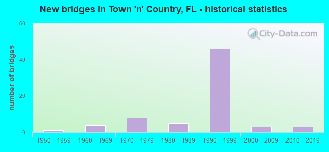
- New bridges - historical statistics
- 11950-1959
- 41960-1969
- 81970-1979
- 51980-1989
- 461990-1999
- 32000-2009
- 32010-2019

- Reconstructed bridges - Historical Statistics
- 31980-1989
- 11990-1999
- 02000-2009
- 172010-2019


- Bridge Condition - Deck
- 4.4%Very good
- 82.2%Good
- 8.9%Satisfactory
- 4.4%Fair

- Bridge Condition - Superstructure
- 4.4%Very good
- 84.4%Good
- 6.7%Satisfactory
- 4.4%Fair

- Bridge Condition - Substructure
- 17.8%Very good
- 73.3%Good
- 8.9%Satisfactory

- Bridge Condition - Channel
- 11.1%Very good
- 58.3%Good
- 25.0%Satisfactory
- 5.6%Fair

- Bridge Condition - Culverts
- 66.7%Good
- 33.3%Satisfactory
Find on map >> Show street view
Structure Number: 10003, Location: 0.2MI NORTH OF WATERS AVE (Lat: 28.029031, Lng: -82.582969), Route carried "on" structure: County highway 589, Year Built: 1967, Year Reconstructed: 1994, Status: Open, Structure Length: 6.25m (20.51ft), Average Daily Traffic: 12,088 (year 2021), Truck Traffic: 5%, Average Future Daily Traffic: 15,110 (year 2041), Design Load: HS 20, Features Intersected: BRUSHY CREEK, Facility Carried by Structure: SHELDON ROAD NB
Minimum Vertical Clearance: 30+ m (98+ ft), Kilometerpoint: 0.000, Lanes on structure: 2, Owner: County Highway Agency, Approaching Roadway Width: 9.4m (30.8ft), Skew: 1 degrees, Material/Design: Prestressed concrete, Design/Construction: Stringer/Multi-beam, Number Of Spans In Main Unit: 5, Length of Maximum Span: 12.5m (41.0ft), Curb or Sidewalk Widths: Left: 0.0m, Right: 1.5m (4.9ft), Curb-To-Curb Width: 9.4m (30.8ft), Out-to-Out Width: 12.1m (39.7ft)
Condition: Deck: Satisfactory, Superstructure: Satisfactory, Substructure: Good, Channel: Good, Operating Rating: 50.3 metric tons, Method Used To Determine Operating Rating: Allowable Stress (AS), Inventory Rating: 45.2 metric tons, Method Used To Determine Inventory Rating: Allowable Stress (AS), Structural Evaluation: Equal to present minimum criteria, Deck Geometry: Meets minimum limits, Waterway Adequacy: Superior to present desirable criteria, Approach Roadway Alignment: Equal to present desirable criteria, Designated Inspection Frequency: Every 24 months, Underwater Inspection Frequency: Every 24 months, Inspection Date: October 2021, Underwater Inspection Date: September 2021, Deck Structure Type: Concrete Cast-file-Place
Find on map >> Show street view
Structure Number: 100248, Location: 1MI W of EISENHOWER BLVD (Lat: 27.981711, Lng: -82.562581), Route carried "on" structure: County highway , Year Built: 1973, Status: Open, Structure Length: 2.65m (8.69ft), Average Daily Traffic: 35,300 (year 2021), Truck Traffic: 5%, Average Future Daily Traffic: 44,125 (year 2041), Design Load: HS 20, Features Intersected: SWEETWATER CREEK, Facility Carried by Structure: MEMORIAL HIGHWAY
Minimum Vertical Clearance: 30+ m (98+ ft), Kilometerpoint: 0.000, Lanes on structure: 4, Owner: County Highway Agency, Approaching Roadway Width: 16.5m (54.1ft), Skew: 21 degrees, Material/Design: Concrete continuous, Design/Construction: Slab, Number Of Spans In Main Unit: 3, Length of Maximum Span: 8.8m (28.9ft), Curb or Sidewalk Widths: Left: 1.5m (4.9ft), Right: 1.5m (4.9ft), Curb-To-Curb Width: 16.5m (54.1ft), Out-to-Out Width: 25.1m (82.3ft)
Condition: Deck: Satisfactory, Superstructure: Good, Substructure: Good, Channel: Good, Operating Rating: 53.9 metric tons, Method Used To Determine Operating Rating: Load Factor (LF), Inventory Rating: 32.3 metric tons, Method Used To Determine Inventory Rating: Load Factor (LF), Structural Evaluation: Better than present minimum criteria, Deck Geometry: Meets minimum limits, Waterway Adequacy: Equal to present desirable criteria, Approach Roadway Alignment: Equal to present desirable criteria, Designated Inspection Frequency: Every 24 months, Underwater Inspection Frequency: Every 24 months, Inspection Date: October 2021, Underwater Inspection Date: September 2021, Deck Structure Type: Concrete Cast-file-Place
Find on map >> Show street view
Structure Number: 100302, Location: 2.8 MILES WEST OF SR-589 (Lat: 28.000728, Lng: -82.593081), Route carried "on" structure: State highway 580, Year Built: 1992, Status: Open, Structure Length: 2.47m (8.10ft), Average Daily Traffic: 63,000 (year 2021), Truck Traffic: 4%, Average Future Daily Traffic: 109,305 (year 2041), Design Load: HS 20, Features Intersected: DICK CREEK
Minimum Vertical Clearance: 30+ m (98+ ft), Kilometerpoint: 6.568, Lanes on structure: 6, Base Highway Network: Yes, Owner: State Highway Agency, Approaching Roadway Width: 25.2m (82.7ft), Skew: 24 degrees, Material/Design: Concrete continuous, Design/Construction: Slab, Number Of Spans In Main Unit: 3, Length of Maximum Span: 8.3m (27.2ft), Curb or Sidewalk Widths: Left: 1.6m (5.2ft), Right: 1.6m (5.2ft), Curb-To-Curb Width: 25.2m (82.7ft), Out-to-Out Width: 35.6m (116.8ft)
Condition: Deck: Good, Superstructure: Good, Substructure: Good, Channel: Good, Operating Rating: 77.1 metric tons, Method Used To Determine Operating Rating: Load Factor (LF), Inventory Rating: 46.3 metric tons, Method Used To Determine Inventory Rating: Load Factor (LF), Structural Evaluation: Better than present minimum criteria, Deck Geometry: Somewhat better than minimum adequacy, Waterway Adequacy: Equal to present desirable criteria, Approach Roadway Alignment: Equal to present desirable criteria, Designated Inspection Frequency: Every 24 months, Underwater Inspection Frequency: Every 24 months, Inspection Date: March 2021, Underwater Inspection Date: Febuary 2021, Deck Structure Type: Concrete Cast-file-Place, Wearing Surface/Protective System: Wearing Surface: Monolithic Concrete, Deck Protection: Epoxy Coated Reinforcing
Find on map >> Show street view
Structure Number: 100303, Location: 2.4 MILES WEST OF SR-589 (Lat: 27.997214, Lng: -82.586561), Route carried "on" structure: State highway 580, Year Built: 1992, Status: Open, Structure Length: 7.95m (26.08ft), Average Daily Traffic: 63,000 (year 2021), Truck Traffic: 4%, Average Future Daily Traffic: 109,305 (year 2041), Design Load: HS 20, Features Intersected: ROCKY CREEK
Minimum Vertical Clearance: 30+ m (98+ ft), Kilometerpoint: 7.289, Lanes on structure: 6, Base Highway Network: Yes, Owner: State Highway Agency, Approaching Roadway Width: 25.1m (82.3ft), Skew: 20 degrees, Material/Design: Concrete continuous, Design/Construction: Slab, Number Of Spans In Main Unit: 9, Length of Maximum Span: 9.1m (29.9ft), Curb or Sidewalk Widths: Left: 1.6m (5.2ft), Right: 1.6m (5.2ft), Curb-To-Curb Width: 25.1m (82.3ft), Out-to-Out Width: 35.5m (116.5ft)
Condition: Deck: Good, Superstructure: Good, Substructure: Good, Channel: Good, Operating Rating: 65.3 metric tons, Method Used To Determine Operating Rating: Load Factor (LF), Inventory Rating: 39.0 metric tons, Method Used To Determine Inventory Rating: Load Factor (LF), Structural Evaluation: Better than present minimum criteria, Deck Geometry: Somewhat better than minimum adequacy, Waterway Adequacy: Equal to present desirable criteria, Approach Roadway Alignment: Equal to present desirable criteria, Designated Inspection Frequency: Every 24 months, Underwater Inspection Frequency: Every 24 months, Inspection Date: March 2021, Underwater Inspection Date: Febuary 2021, Deck Structure Type: Concrete Cast-file-Place
Find on map >> Show street view
Structure Number: 100335, Location: 1.0 MILE WEST OF SR-589 (Lat: 27.996489, Lng: -82.561869), Route carried "on" structure: State highway 580, Year Built: 1977, Status: Open, Structure Length: 2.74m (8.99ft), Average Daily Traffic: 59,000 (year 2021), Truck Traffic: 3%, Average Future Daily Traffic: 102,365 (year 2041), Design Load: HS 20+Mod, Features Intersected: SWEETWATER CREEK
Minimum Vertical Clearance: 30+ m (98+ ft), Kilometerpoint: 9.759, Lanes on structure: 6, Base Highway Network: Yes, Owner: State Highway Agency, Approaching Roadway Width: 24.0m (78.7ft), Skew: 20 degrees, Material/Design: Prestressed concrete, Design/Construction: Slab, Number Of Spans In Main Unit: 3, Length of Maximum Span: 9.1m (29.9ft), Curb or Sidewalk Widths: Left: 1.4m (4.6ft), Right: 1.4m (4.6ft), Curb-To-Curb Width: 24.0m (78.7ft), Out-to-Out Width: 32.8m (107.6ft)
Condition: Deck: Good, Superstructure: Good, Substructure: Good, Channel: Fair, Operating Rating: 56.1 metric tons, Method Used To Determine Operating Rating: Load and Resistance Factor (LRFR), Inventory Rating: 35.0 metric tons, Method Used To Determine Inventory Rating: Load and Resistance Factor (LRFR), Structural Evaluation: Better than present minimum criteria, Deck Geometry: Somewhat better than minimum adequacy, Waterway Adequacy: Equal to present desirable criteria, Approach Roadway Alignment: Equal to present desirable criteria, Length Of Structure Improvement: 0.27m (0.89ft), Designated Inspection Frequency: Every 24 months, Inspection Date: March 2021, Bridge Improvement Cost: $192,000, Roadway Improvement Cost: $19,000, Total Project Cost: $210,000, Deck Structure Type: Concrete Precast Panels, Wearing Surface/Protective System: Wearing Surface: Bituminous
Find on map >> Show street view
Structure Number: 100515, Location: 1 MI S OF HILLSBRGH AVE (Lat: 27.981767, Lng: -82.546264), Route carried "on" structure: State highway 589, Year Built: 1994, Status: Open, Structure Length: 4.45m (14.60ft), Average Daily Traffic: 38,150 (year 2020), Truck Traffic: 10%, Average Future Daily Traffic: 66,190 (year 2042), Design Load: HS 20+Mod, Features Intersected: MEMORIAL HWY
Minimum Vertical Clearance: 30+ m (98+ ft), Kilometerpoint: 1.704, Lanes on structure: 4, Lanes under structure: 6, Base Highway Network: Yes, Toll: On toll road, Owner: State Toll Authority, Approaching Roadway Width: 22.9m (75.1ft), Material/Design: Prestressed concrete, Design/Construction: Stringer/Multi-beam, Number Of Spans In Main Unit: 1, Length of Maximum Span: 44.5m (146.0ft), Curb-To-Curb Width: 23.2m (76.1ft), Out-to-Out Width: 24.5m (80.4ft)
Condition: Deck: Good, Superstructure: Good, Substructure: Good, Operating Rating: 46.1 metric tons, Method Used To Determine Operating Rating: Load Factor (LF), Inventory Rating: 40.4 metric tons, Method Used To Determine Inventory Rating: Load Factor (LF), Structural Evaluation: Better than present minimum criteria, Deck Geometry: Superior to present desirable criteria, Underclear: Equal to present minimum criteria, Approach Roadway Alignment: Equal to present desirable criteria, Designated Inspection Frequency: Every 24 months, Inspection Date: Febuary 2022, Deck Structure Type: Concrete Cast-file-Place
Find on map >> Show street view
Structure Number: 100516, Location: 1.0 MI S OF HILLSBRGH AVE (Lat: 27.981747, Lng: -82.546511), Route carried "on" structure: State highway 589, Year Built: 1994, Status: Open, Structure Length: 4.45m (14.60ft), Average Daily Traffic: 38,150 (year 2020), Truck Traffic: 10%, Average Future Daily Traffic: 66,190 (year 2042), Design Load: HS 20+Mod, Features Intersected: MEMORIAL HWY
Minimum Vertical Clearance: 30+ m (98+ ft), Kilometerpoint: 1.704, Lanes on structure: 4, Lanes under structure: 6, Base Highway Network: Yes, Toll: On toll road, Owner: State Toll Authority, Approaching Roadway Width: 22.8m (74.8ft), Material/Design: Prestressed concrete, Design/Construction: Stringer/Multi-beam, Number Of Spans In Main Unit: 1, Length of Maximum Span: 44.5m (146.0ft), Curb-To-Curb Width: 22.8m (74.8ft), Out-to-Out Width: 23.3m (76.4ft)
Condition: Deck: Good, Superstructure: Good, Substructure: Good, Operating Rating: 45.4 metric tons, Method Used To Determine Operating Rating: Load Factor (LF), Inventory Rating: 40.5 metric tons, Method Used To Determine Inventory Rating: Load Factor (LF), Structural Evaluation: Better than present minimum criteria, Deck Geometry: Superior to present desirable criteria, Underclear: Equal to present minimum criteria, Approach Roadway Alignment: Equal to present desirable criteria, Designated Inspection Frequency: Every 24 months, Inspection Date: Febuary 2022, Deck Structure Type: Concrete Cast-file-Place
Find on map >> Show street view
Structure Number: 100518, Location: 0.5 MI N OF MEMORIAL HWY (Lat: 27.989083, Lng: -82.545836), Route carried "on" structure: State highway 589, Year Built: 1994, Year Reconstructed: 2016, Status: Open, Structure Length: 0.76m (2.49ft), Average Daily Traffic: 79,600 (year 2020), Truck Traffic: 10%, Average Future Daily Traffic: 138,106 (year 2042), Design Load: HL 93, Features Intersected: AIR CARGO DITCH
Minimum Vertical Clearance: 30+ m (98+ ft), Kilometerpoint: 2.544, Lanes on structure: 14, Base Highway Network: Yes, Toll: On toll road, Owner: State Toll Authority, Approaching Roadway Width: 61.0m (200.1ft), Skew: 10 degrees, Material/Design: Concrete, Design/Construction: Culvert, Number Of Spans In Main Unit: 2, Length of Maximum Span: 3.7m (12.1ft)
Condition: Channel: Satisfactory, Culverts: Satisfactory, Operating Rating: 48.0 metric tons, Method Used To Determine Operating Rating: Load and Resistance Factor (LRFR), Inventory Rating: 36.9 metric tons, Method Used To Determine Inventory Rating: Load and Resistance Factor (LRFR), Structural Evaluation: Equal to present minimum criteria, Waterway Adequacy: Equal to present desirable criteria, Approach Roadway Alignment: Equal to present desirable criteria, Designated Inspection Frequency: Every 24 months, Inspection Date: Febuary 2022
Find on map >> Show street view
Structure Number: 100519, Location: 1.9 MI N OF SR 60 (Lat: 27.996347, Lng: -82.545869), Route carried "on" structure: State highway 589, Year Built: 1994, Year Reconstructed: 2016, Status: Open, Structure Length: 7.64m (25.07ft), Average Daily Traffic: 39,800 (year 2020), Truck Traffic: 10%, Average Future Daily Traffic: 69,053 (year 2042), Design Load: HL 93, Features Intersected: HILLSBOROUGH AVE
Minimum Vertical Clearance: 30+ m (98+ ft), Kilometerpoint: 3.302, Lanes on structure: 4, Lanes under structure: 10, Base Highway Network: Yes, Toll: On toll road, Owner: State Toll Authority, Approaching Roadway Width: 21.1m (69.2ft), Material/Design: Steel continuous, Design/Construction: Stringer/Multi-beam, Number Of Spans In Main Unit: 2, Length of Maximum Span: 47.5m (155.8ft), Curb-To-Curb Width: 21.1m (69.2ft), Out-to-Out Width: 21.6m (70.9ft)
Condition: Deck: Good, Superstructure: Very good, Substructure: Very good, Operating Rating: 43.1 metric tons, Method Used To Determine Operating Rating: Load and Resistance Factor (LRFR), Inventory Rating: 33.3 metric tons, Method Used To Determine Inventory Rating: Load and Resistance Factor (LRFR), Structural Evaluation: Equal to present desirable criteria, Deck Geometry: Better than present minimum criteria, Underclear: Equal to present minimum criteria, Approach Roadway Alignment: Equal to present desirable criteria, Designated Inspection Frequency: Every 24 months, Inspection Date: Febuary 2022, Deck Structure Type: Concrete Cast-file-Place
Find on map >> Show street view
Structure Number: 10052, Location: 1.9 MI N OF SR 60 (Lat: 27.996311, Lng: -82.546092), Route carried "on" structure: State highway 589, Year Built: 1994, Year Reconstructed: 2016, Status: Open, Structure Length: 7.64m (25.07ft), Average Daily Traffic: 39,800 (year 2020), Truck Traffic: 10%, Average Future Daily Traffic: 69,053 (year 2042), Design Load: HL 93, Features Intersected: HILLSBOROUGH AVE
Minimum Vertical Clearance: 30+ m (98+ ft), Kilometerpoint: 3.302, Lanes on structure: 4, Lanes under structure: 10, Base Highway Network: Yes, Toll: On toll road, Owner: State Toll Authority, Approaching Roadway Width: 20.7m (67.9ft), Material/Design: Steel continuous, Design/Construction: Stringer/Multi-beam, Number Of Spans In Main Unit: 2, Length of Maximum Span: 47.5m (155.8ft), Curb-To-Curb Width: 20.7m (67.9ft), Out-to-Out Width: 21.6m (70.9ft)
Condition: Deck: Good, Superstructure: Good, Substructure: Good, Operating Rating: 43.1 metric tons, Method Used To Determine Operating Rating: Load and Resistance Factor (LRFR), Inventory Rating: 33.3 metric tons, Method Used To Determine Inventory Rating: Load and Resistance Factor (LRFR), Structural Evaluation: Better than present minimum criteria, Deck Geometry: Equal to present minimum criteria, Underclear: Equal to present minimum criteria, Approach Roadway Alignment: Equal to present desirable criteria, Designated Inspection Frequency: Every 24 months, Inspection Date: Febuary 2022, Deck Structure Type: Concrete Cast-file-Place
Find on map >> Show street view
Structure Number: 100521, Location: 0.2MI N OF HILLSBORO. AVE (Lat: 28.000075, Lng: -82.550236), Route carried "on" structure: City street , Year Built: 1994, Status: Open, Structure Length: 2.38m (7.81ft), Average Daily Traffic: 10,300 (year 2018), Truck Traffic: 6%, Average Future Daily Traffic: 17,870 (year 2040), Design Load: HS 20, Features Intersected: LOMA SLOUGH, Facility Carried by Structure: GEORGE ROAD
Minimum Vertical Clearance: 30+ m (98+ ft), Kilometerpoint: 2.868, Lanes on structure: 2, Owner: County Highway Agency, Approaching Roadway Width: 9.9m (32.5ft), Material/Design: Concrete continuous, Design/Construction: Slab, Number Of Spans In Main Unit: 3, Length of Maximum Span: 9.1m (29.9ft), Curb or Sidewalk Widths: Left: 1.6m (5.2ft), Right: 1.6m (5.2ft), Curb-To-Curb Width: 10.1m (33.1ft), Out-to-Out Width: 14.6m (47.9ft)
Condition: Deck: Good, Superstructure: Good, Substructure: Good, Channel: Satisfactory, Operating Rating: 71.4 metric tons, Method Used To Determine Operating Rating: Load Factor (LF), Inventory Rating: 42.8 metric tons, Method Used To Determine Inventory Rating: Load Factor (LF), Structural Evaluation: Better than present minimum criteria, Deck Geometry: Meets minimum limits, Waterway Adequacy: Superior to present desirable criteria, Approach Roadway Alignment: Equal to present desirable criteria, Designated Inspection Frequency: Every 24 months, Inspection Date: Febuary 2020, Deck Structure Type: Concrete Cast-file-Place
Find on map >> Show street view
Structure Number: 100522, Location: 0.3 MI N OF HILLSBRGH AVE (Lat: 28.000064, Lng: -82.545508), Route carried "on" structure: State highway 589, Year Built: 1994, Year Reconstructed: 2016, Status: Open, Structure Length: 2.77m (9.09ft), Average Daily Traffic: 36,392 (year 2020), Truck Traffic: 7%, Average Future Daily Traffic: 63,140 (year 2042), Design Load: HL 93, Features Intersected: HENRY ST DITCH
Minimum Vertical Clearance: 30+ m (98+ ft), Kilometerpoint: 3.750, Lanes on structure: 5, Base Highway Network: Yes, Toll: On toll road, Owner: State Toll Authority, Approaching Roadway Width: 24.8m (81.4ft), Skew: 1 degrees, Material/Design: Concrete continuous, Design/Construction: Slab, Number Of Spans In Main Unit: 3, Length of Maximum Span: 10.4m (34.1ft), Curb-To-Curb Width: 24.8m (81.4ft), Out-to-Out Width: 25.8m (84.6ft)
Condition: Deck: Good, Superstructure: Good, Substructure: Satisfactory, Channel: Good, Operating Rating: 45.7 metric tons, Method Used To Determine Operating Rating: Load and Resistance Factor (LRFR), Inventory Rating: 35.2 metric tons, Method Used To Determine Inventory Rating: Load and Resistance Factor (LRFR), Structural Evaluation: Equal to present minimum criteria, Deck Geometry: Better than present minimum criteria, Waterway Adequacy: Superior to present desirable criteria, Approach Roadway Alignment: Equal to present desirable criteria, Designated Inspection Frequency: Every 24 months, Inspection Date: Febuary 2022, Deck Structure Type: Concrete Cast-file-Place
Find on map >> Show street view
Structure Number: 100523, Location: 0.3 MI N OF HILLSBRGH AVE (Lat: 28.000089, Lng: -82.545225), Route carried "on" structure: State highway 589, Year Built: 1994, Year Reconstructed: 2016, Status: Open, Structure Length: 2.77m (9.09ft), Average Daily Traffic: 36,392 (year 2020), Truck Traffic: 7%, Average Future Daily Traffic: 63,140 (year 2042), Design Load: HL 93, Features Intersected: HENRY ST DITCH
Minimum Vertical Clearance: 30+ m (98+ ft), Kilometerpoint: 3.755, Lanes on structure: 5, Base Highway Network: Yes, Toll: On toll road, Owner: State Toll Authority, Approaching Roadway Width: 24.4m (80.1ft), Skew: 1 degrees, Material/Design: Concrete continuous, Design/Construction: Slab, Number Of Spans In Main Unit: 3, Length of Maximum Span: 10.4m (34.1ft), Curb-To-Curb Width: 24.4m (80.1ft), Out-to-Out Width: 25.4m (83.3ft)
Condition: Deck: Good, Superstructure: Good, Substructure: Very good, Channel: Good, Operating Rating: 47.0 metric tons, Method Used To Determine Operating Rating: Load and Resistance Factor (LRFR), Inventory Rating: 36.3 metric tons, Method Used To Determine Inventory Rating: Load and Resistance Factor (LRFR), Structural Evaluation: Better than present minimum criteria, Deck Geometry: Equal to present minimum criteria, Waterway Adequacy: Superior to present desirable criteria, Approach Roadway Alignment: Equal to present desirable criteria, Designated Inspection Frequency: Every 24 months, Inspection Date: Febuary 2022, Deck Structure Type: Concrete Cast-file-Place
Find on map >> Show street view
Structure Number: 100524, Location: 0.8 MI N OF HILLSBRGH AVE (Lat: 28.007372, Lng: -82.545775), Route carried "on" structure: State highway 589, Year Built: 1994, Year Reconstructed: 2016, Status: Open, Structure Length: 4.44m (14.57ft), Average Daily Traffic: 36,392 (year 2020), Truck Traffic: 7%, Average Future Daily Traffic: 63,140 (year 2042), Design Load: HL 93, Features Intersected: JOHNS RD
Minimum Vertical Clearance: 30+ m (98+ ft), Kilometerpoint: 4.561, Lanes on structure: 4, Lanes under structure: 2, Base Highway Network: Yes, Toll: On toll road, Owner: State Toll Authority, Approaching Roadway Width: 20.7m (67.9ft), Material/Design: Prestressed concrete, Design/Construction: Stringer/Multi-beam, Number Of Spans In Main Unit: 3, Length of Maximum Span: 23.2m (76.1ft), Curb-To-Curb Width: 20.7m (67.9ft), Out-to-Out Width: 21.7m (71.2ft)
Condition: Deck: Good, Superstructure: Good, Substructure: Good, Operating Rating: 46.4 metric tons, Method Used To Determine Operating Rating: Load and Resistance Factor (LRFR), Inventory Rating: 35.7 metric tons, Method Used To Determine Inventory Rating: Load and Resistance Factor (LRFR), Structural Evaluation: Better than present minimum criteria, Deck Geometry: Equal to present minimum criteria, Underclear: Superior to present desirable criteria, Approach Roadway Alignment: Equal to present desirable criteria, Designated Inspection Frequency: Every 24 months, Inspection Date: Febuary 2022, Deck Structure Type: Concrete Cast-file-Place
Find on map >> Show street view
Structure Number: 100525, Location: 0.8 MI N OF HILLSBRGH AVE (Lat: 28.007353, Lng: -82.545528), Route carried "on" structure: State highway 589, Year Built: 1994, Year Reconstructed: 2016, Status: Open, Structure Length: 4.45m (14.60ft), Average Daily Traffic: 36,392 (year 2020), Truck Traffic: 7%, Average Future Daily Traffic: 63,140 (year 2042), Design Load: HL 93, Features Intersected: JOHNS RD
Minimum Vertical Clearance: 30+ m (98+ ft), Kilometerpoint: 4.561, Lanes on structure: 4, Lanes under structure: 2, Base Highway Network: Yes, Toll: On toll road, Owner: State Toll Authority, Approaching Roadway Width: 20.7m (67.9ft), Material/Design: Prestressed concrete, Design/Construction: Stringer/Multi-beam, Number Of Spans In Main Unit: 3, Length of Maximum Span: 23.2m (76.1ft), Curb-To-Curb Width: 20.7m (67.9ft), Out-to-Out Width: 21.6m (70.9ft)
Condition: Deck: Good, Superstructure: Good, Substructure: Good, Operating Rating: 46.9 metric tons, Method Used To Determine Operating Rating: Load and Resistance Factor (LRFR), Inventory Rating: 36.2 metric tons, Method Used To Determine Inventory Rating: Load and Resistance Factor (LRFR), Structural Evaluation: Better than present minimum criteria, Deck Geometry: Equal to present minimum criteria, Underclear: Superior to present desirable criteria, Approach Roadway Alignment: Equal to present desirable criteria, Designated Inspection Frequency: Every 24 months, Inspection Date: Febuary 2022, Deck Structure Type: Concrete Cast-file-Place
Find on map >> Show street view
Structure Number: 100528, Location: 1.2 MI N OF HILLSBRGH AVE (Lat: 28.013792, Lng: -82.545556), Route carried "on" structure: State highway 589, Year Built: 1994, Year Reconstructed: 2016, Status: Open, Structure Length: 5.09m (16.70ft), Average Daily Traffic: 36,392 (year 2020), Truck Traffic: 7%, Average Future Daily Traffic: 63,140 (year 2042), Design Load: HL 93, Features Intersected: CHANNEL G
Minimum Vertical Clearance: 30+ m (98+ ft), Kilometerpoint: 5.269, Lanes on structure: 4, Base Highway Network: Yes, Toll: On toll road, Owner: State Toll Authority, Approaching Roadway Width: 20.7m (67.9ft), Skew: 3 degrees, Material/Design: Prestressed concrete, Design/Construction: Stringer/Multi-beam, Number Of Spans In Main Unit: 3, Length of Maximum Span: 17.1m (56.1ft), Curb-To-Curb Width: 20.7m (67.9ft), Out-to-Out Width: 21.6m (70.9ft)
Condition: Deck: Good, Superstructure: Good, Substructure: Good, Channel: Good, Operating Rating: 48.4 metric tons, Method Used To Determine Operating Rating: Load and Resistance Factor (LRFR), Inventory Rating: 37.2 metric tons, Method Used To Determine Inventory Rating: Load and Resistance Factor (LRFR), Structural Evaluation: Better than present minimum criteria, Deck Geometry: Equal to present minimum criteria, Waterway Adequacy: Superior to present desirable criteria, Approach Roadway Alignment: Equal to present desirable criteria, Designated Inspection Frequency: Every 24 months, Underwater Inspection Frequency: Every 24 months, Inspection Date: Febuary 2022, Underwater Inspection Date: Febuary 2022, Deck Structure Type: Concrete Cast-file-Place
Find on map >> Show street view
Structure Number: 100529, Location: 1.2 MI N OF HILLSBRGH AVE (Lat: 28.013928, Lng: -82.545328), Route carried "on" structure: State highway 589, Year Built: 1994, Year Reconstructed: 2016, Status: Open, Structure Length: 5.09m (16.70ft), Average Daily Traffic: 36,392 (year 2020), Truck Traffic: 7%, Average Future Daily Traffic: 63,140 (year 2042), Design Load: HL 93, Features Intersected: CHANNEL G
Minimum Vertical Clearance: 30+ m (98+ ft), Kilometerpoint: 5.287, Lanes on structure: 4, Base Highway Network: Yes, Toll: On toll road, Owner: State Toll Authority, Approaching Roadway Width: 19.9m (65.3ft), Skew: 3 degrees, Material/Design: Prestressed concrete, Design/Construction: Stringer/Multi-beam, Number Of Spans In Main Unit: 3, Length of Maximum Span: 17.1m (56.1ft), Curb-To-Curb Width: 20.1m (65.9ft), Out-to-Out Width: 21.6m (70.9ft)
Condition: Deck: Good, Superstructure: Good, Substructure: Good, Channel: Good, Operating Rating: 49.0 metric tons, Method Used To Determine Operating Rating: Load and Resistance Factor (LRFR), Inventory Rating: 37.9 metric tons, Method Used To Determine Inventory Rating: Load and Resistance Factor (LRFR), Structural Evaluation: Better than present minimum criteria, Deck Geometry: Equal to present minimum criteria, Waterway Adequacy: Superior to present desirable criteria, Approach Roadway Alignment: Equal to present desirable criteria, Designated Inspection Frequency: Every 24 months, Underwater Inspection Frequency: Every 24 months, Inspection Date: Febuary 2022, Underwater Inspection Date: Febuary 2022, Deck Structure Type: Concrete Cast-file-Place
Find on map >> Show street view
Structure Number: 10053, Location: 1.4 MI N OF HILLSBRGH AVE (Lat: 28.016503, Lng: -82.545439), Route carried "on" structure: State highway 589, Year Built: 1994, Year Reconstructed: 2016, Status: Open, Structure Length: 4.05m (13.29ft), Average Daily Traffic: 36,392 (year 2020), Truck Traffic: 7%, Average Future Daily Traffic: 63,140 (year 2042), Design Load: HL 93, Features Intersected: BARRY RD
Minimum Vertical Clearance: 30+ m (98+ ft), Kilometerpoint: 5.575, Lanes on structure: 4, Lanes under structure: 2, Base Highway Network: Yes, Toll: On toll road, Owner: State Toll Authority, Approaching Roadway Width: 20.7m (67.9ft), Material/Design: Prestressed concrete, Design/Construction: Stringer/Multi-beam, Number Of Spans In Main Unit: 3, Length of Maximum Span: 19.5m (64.0ft), Curb-To-Curb Width: 20.7m (67.9ft), Out-to-Out Width: 21.6m (70.9ft)
Condition: Deck: Good, Superstructure: Good, Substructure: Good, Operating Rating: 45.4 metric tons, Method Used To Determine Operating Rating: Load and Resistance Factor (LRFR), Inventory Rating: 36.3 metric tons, Method Used To Determine Inventory Rating: Load and Resistance Factor (LRFR), Structural Evaluation: Better than present minimum criteria, Deck Geometry: Equal to present minimum criteria, Underclear: Superior to present desirable criteria, Approach Roadway Alignment: Equal to present desirable criteria, Designated Inspection Frequency: Every 24 months, Inspection Date: Febuary 2022, Deck Structure Type: Concrete Cast-file-Place
Find on map >> Show street view
Structure Number: 100531, Location: 1.4 MI N OF HILLSBRGH AVE (Lat: 28.016506, Lng: -82.545219), Route carried "on" structure: State highway 589, Year Built: 1994, Year Reconstructed: 2016, Status: Open, Structure Length: 4.05m (13.29ft), Average Daily Traffic: 36,392 (year 2020), Truck Traffic: 7%, Average Future Daily Traffic: 63,140 (year 2042), Design Load: HL 93, Features Intersected: BARRY RD
Minimum Vertical Clearance: 30+ m (98+ ft), Kilometerpoint: 5.575, Lanes on structure: 4, Lanes under structure: 2, Base Highway Network: Yes, Toll: On toll road, Owner: State Toll Authority, Approaching Roadway Width: 20.8m (68.2ft), Material/Design: Prestressed concrete, Design/Construction: Stringer/Multi-beam, Number Of Spans In Main Unit: 3, Length of Maximum Span: 19.5m (64.0ft), Curb-To-Curb Width: 20.8m (68.2ft), Out-to-Out Width: 21.7m (71.2ft)
Condition: Deck: Good, Superstructure: Good, Substructure: Good, Operating Rating: 45.4 metric tons, Method Used To Determine Operating Rating: Load and Resistance Factor (LRFR), Inventory Rating: 36.3 metric tons, Method Used To Determine Inventory Rating: Load and Resistance Factor (LRFR), Structural Evaluation: Better than present minimum criteria, Deck Geometry: Equal to present minimum criteria, Underclear: Better than present minimum criteria, Approach Roadway Alignment: Equal to present desirable criteria, Designated Inspection Frequency: Every 24 months, Inspection Date: Febuary 2022, Deck Structure Type: Concrete Cast-file-Place
Find on map >> Show street view
Structure Number: 100532, Location: 2 MI N OF HILLSBRGH AVE (Lat: 28.025672, Lng: -82.544475), Route carried "on" structure: State highway 589, Year Built: 1994, Year Reconstructed: 2016, Status: Open, Structure Length: 7.65m (25.10ft), Average Daily Traffic: 36,392 (year 2020), Truck Traffic: 7%, Average Future Daily Traffic: 63,140 (year 2042), Design Load: HL 93, Features Intersected: WATERS AVE
Minimum Vertical Clearance: 30+ m (98+ ft), Kilometerpoint: 6.584, Lanes on structure: 4, Lanes under structure: 7, Base Highway Network: Yes, Toll: On toll road, Owner: State Toll Authority, Approaching Roadway Width: 20.7m (67.9ft), Material/Design: Steel, Design/Construction: Stringer/Multi-beam, Number Of Spans In Main Unit: 1, Length of Maximum Span: 76.5m (251.0ft), Curb-To-Curb Width: 20.7m (67.9ft), Out-to-Out Width: 21.7m (71.2ft)
Condition: Deck: Good, Superstructure: Good, Substructure: Good, Operating Rating: 75.1 metric tons, Method Used To Determine Operating Rating: Load and Resistance Factor (LRFR), Inventory Rating: 58.2 metric tons, Method Used To Determine Inventory Rating: Load and Resistance Factor (LRFR), Structural Evaluation: Better than present minimum criteria, Deck Geometry: Equal to present minimum criteria, Underclear: Superior to present desirable criteria, Approach Roadway Alignment: Equal to present desirable criteria, Designated Inspection Frequency: Every 24 months, Inspection Date: Febuary 2022, Deck Structure Type: Concrete Cast-file-Place
Find on map >> Show street view
Structure Number: 100533, Location: 2MI N OF HILLSBRGH AVE (Lat: 28.025672, Lng: -82.544225), Route carried "on" structure: State highway 589, Year Built: 1994, Year Reconstructed: 2016, Status: Open, Structure Length: 7.65m (25.10ft), Average Daily Traffic: 36,392 (year 2020), Truck Traffic: 7%, Average Future Daily Traffic: 63,140 (year 2042), Design Load: HL 93, Features Intersected: WATERS AVE
Minimum Vertical Clearance: 30+ m (98+ ft), Kilometerpoint: 6.584, Lanes on structure: 4, Lanes under structure: 7, Base Highway Network: Yes, Toll: On toll road, Owner: State Toll Authority, Approaching Roadway Width: 20.7m (67.9ft), Material/Design: Steel, Design/Construction: Stringer/Multi-beam, Number Of Spans In Main Unit: 1, Length of Maximum Span: 76.5m (251.0ft), Curb-To-Curb Width: 20.7m (67.9ft), Out-to-Out Width: 21.7m (71.2ft)
Condition: Deck: Good, Superstructure: Good, Substructure: Good, Operating Rating: 75.1 metric tons, Method Used To Determine Operating Rating: Load and Resistance Factor (LRFR), Inventory Rating: 58.2 metric tons, Method Used To Determine Inventory Rating: Load and Resistance Factor (LRFR), Structural Evaluation: Better than present minimum criteria, Deck Geometry: Equal to present minimum criteria, Underclear: Superior to present desirable criteria, Approach Roadway Alignment: Equal to present desirable criteria, Designated Inspection Frequency: Every 24 months, Inspection Date: Febuary 2022, Deck Structure Type: Concrete Cast-file-Place
Find on map >> Show street view
Structure Number: 100536, Location: 0.65MI S OF LINEBAUGH AVE (Lat: 28.036617, Lng: -82.549606), Route carried "on" structure: State highway 589, Year Built: 1994, Year Reconstructed: 2016, Status: Open, Structure Length: 4.10m (13.45ft), Average Daily Traffic: 31,650 (year 2020), Truck Traffic: 10%, Average Future Daily Traffic: 54,913 (year 2042), Design Load: HL 93, Features Intersected: HENDERSON ROAD
Minimum Vertical Clearance: 30+ m (98+ ft), Kilometerpoint: 8.129, Lanes on structure: 4, Lanes under structure: 2, Base Highway Network: Yes, Toll: On toll road, Owner: State Toll Authority, Approaching Roadway Width: 20.7m (67.9ft), Material/Design: Prestressed concrete, Design/Construction: Stringer/Multi-beam, Number Of Spans In Main Unit: 3, Length of Maximum Span: 19.7m (64.6ft), Curb-To-Curb Width: 20.7m (67.9ft), Out-to-Out Width: 21.7m (71.2ft)
Condition: Deck: Good, Superstructure: Good, Substructure: Very good, Operating Rating: 48.6 metric tons, Method Used To Determine Operating Rating: Load and Resistance Factor (LRFR), Inventory Rating: 38.8 metric tons, Method Used To Determine Inventory Rating: Load and Resistance Factor (LRFR), Structural Evaluation: Better than present minimum criteria, Deck Geometry: Equal to present minimum criteria, Underclear: Superior to present desirable criteria, Approach Roadway Alignment: Equal to present desirable criteria, Designated Inspection Frequency: Every 24 months, Inspection Date: Febuary 2020, Deck Structure Type: Concrete Cast-file-Place
Find on map >> Show street view
Structure Number: 100537, Location: 0.65MI S OF LINEBAUGH AVE (Lat: 28.036800, Lng: -82.549544), Route carried "on" structure: State highway 589, Year Built: 1994, Year Reconstructed: 2016, Status: Open, Structure Length: 4.10m (13.45ft), Average Daily Traffic: 31,650 (year 2020), Truck Traffic: 10%, Average Future Daily Traffic: 54,913 (year 2042), Design Load: HL 93, Features Intersected: HENDERSON ROAD
Minimum Vertical Clearance: 30+ m (98+ ft), Kilometerpoint: 8.129, Lanes on structure: 5, Lanes under structure: 2, Base Highway Network: Yes, Toll: On toll road, Owner: State Toll Authority, Approaching Roadway Width: 24.4m (80.1ft), Material/Design: Prestressed concrete, Design/Construction: Stringer/Multi-beam, Number Of Spans In Main Unit: 3, Length of Maximum Span: 19.7m (64.6ft), Curb-To-Curb Width: 24.4m (80.1ft), Out-to-Out Width: 25.4m (83.3ft)
Condition: Deck: Good, Superstructure: Good, Substructure: Very good, Operating Rating: 43.7 metric tons, Method Used To Determine Operating Rating: Load and Resistance Factor (LRFR), Inventory Rating: 36.3 metric tons, Method Used To Determine Inventory Rating: Load and Resistance Factor (LRFR), Structural Evaluation: Better than present minimum criteria, Deck Geometry: Equal to present minimum criteria, Underclear: Superior to present desirable criteria, Approach Roadway Alignment: Equal to present desirable criteria, Designated Inspection Frequency: Every 24 months, Inspection Date: Febuary 2020, Deck Structure Type: Concrete Cast-file-Place
Find on map >> Show street view
Structure Number: 100538, Location: 0.1MI S OF LINEBAUGH AVE (Lat: 28.039175, Lng: -82.557783), Route carried "on" structure: State highway 589, Year Built: 1994, Year Reconstructed: 2016, Status: Open, Structure Length: 3.13m (10.27ft), Average Daily Traffic: 31,650 (year 2020), Truck Traffic: 10%, Average Future Daily Traffic: 54,913 (year 2042), Design Load: HL 93, Features Intersected: CSX RR
Minimum Vertical Clearance: 30+ m (98+ ft), Kilometerpoint: 8.982, Lanes on structure: 4, Base Highway Network: Yes, Toll: On toll road, Owner: State Toll Authority, Approaching Roadway Width: 21.8m (71.5ft), Skew: 5 degrees, Material/Design: Prestressed concrete, Design/Construction: Stringer/Multi-beam, Number Of Spans In Main Unit: 1, Length of Maximum Span: 31.3m (102.7ft), Curb-To-Curb Width: 21.8m (71.5ft), Out-to-Out Width: 23.3m (76.4ft)
Condition: Deck: Good, Superstructure: Good, Substructure: Good, Operating Rating: 67.0 metric tons, Method Used To Determine Operating Rating: Load and Resistance Factor (LRFR), Inventory Rating: 51.0 metric tons, Method Used To Determine Inventory Rating: Load and Resistance Factor (LRFR), Structural Evaluation: Better than present minimum criteria, Deck Geometry: Better than present minimum criteria, Underclear: Superior to present desirable criteria, Approach Roadway Alignment: Better than present minimum criteria, Designated Inspection Frequency: Every 24 months, Inspection Date: Febuary 2022, Deck Structure Type: Concrete Cast-file-Place
Find on map >> Show street view
Structure Number: 100539, Location: 0.1MI S OF LINEBAUGH AVE (Lat: 28.039122, Lng: -82.557311), Route carried "on" structure: State highway 589, Year Built: 1994, Year Reconstructed: 2016, Status: Open, Structure Length: 3.36m (11.02ft), Average Daily Traffic: 31,650 (year 2020), Truck Traffic: 10%, Average Future Daily Traffic: 54,913 (year 2042), Design Load: HL 93, Features Intersected: CSX RR
Minimum Vertical Clearance: 30+ m (98+ ft), Kilometerpoint: 8.943, Lanes on structure: 4, Base Highway Network: Yes, Toll: On toll road, Owner: State Toll Authority, Approaching Roadway Width: 21.8m (71.5ft), Skew: 5 degrees, Material/Design: Prestressed concrete, Design/Construction: Stringer/Multi-beam, Number Of Spans In Main Unit: 1, Length of Maximum Span: 33.6m (110.2ft), Curb-To-Curb Width: 21.8m (71.5ft), Out-to-Out Width: 23.3m (76.4ft)
Condition: Deck: Good, Superstructure: Good, Substructure: Good, Operating Rating: 57.2 metric tons, Method Used To Determine Operating Rating: Load and Resistance Factor (LRFR), Inventory Rating: 51.6 metric tons, Method Used To Determine Inventory Rating: Load and Resistance Factor (LRFR), Structural Evaluation: Better than present minimum criteria, Deck Geometry: Better than present minimum criteria, Underclear: Superior to present desirable criteria, Approach Roadway Alignment: Better than present minimum criteria, Designated Inspection Frequency: Every 24 months, Inspection Date: Febuary 2022, Deck Structure Type: Concrete Cast-file-Place
Find on map >> Show street view
Structure Number: 100573, Location: 0.6 MI N OF SR-60 (Lat: 27.976750, Lng: -82.546389), Route carried "on" structure: State highway 589, Year Built: 2009, Status: Open, Structure Length: 3.99m (13.09ft), Average Daily Traffic: 8,750 (year 2020), Truck Traffic: 10%, Average Future Daily Traffic: 15,181 (year 2042), Design Load: HS 20+Mod, Features Intersected: INDEPENDENCE PKWY NB
Minimum Vertical Clearance: 30+ m (98+ ft), Kilometerpoint: 1.399, Lanes on structure: 2, Lanes under structure: 2, Base Highway Network: Yes, Toll: On toll road, Owner: State Highway Agency, Approaching Roadway Width: 13.4m (44.0ft), Skew: 9 degrees, Material/Design: Prestressed concrete, Design/Construction: Stringer/Multi-beam, Number Of Spans In Main Unit: 1, Length of Maximum Span: 39.9m (130.9ft), Curb-To-Curb Width: 13.4m (44.0ft), Out-to-Out Width: 14.6m (47.9ft)
Condition: Deck: Very good, Superstructure: Good, Substructure: Very good, Inventory Rating: 64.8 metric tons, Method Used To Determine Inventory Rating: Load Factor (LF), Structural Evaluation: Better than present minimum criteria, Deck Geometry: Superior to present desirable criteria, Underclear: Equal to present minimum criteria, Approach Roadway Alignment: Equal to present desirable criteria, Designated Inspection Frequency: Every 24 months, Inspection Date: June 2020, Deck Structure Type: Concrete Cast-file-Place
Find on map >> Show street view
Structure Number: 100581, Location: 4 MILES WEST OF SR-589 (Lat: 28.010278, Lng: -82.608028), Route carried "on" structure: State highway 580, Year Built: 1992, Status: Open, Structure Length: 6.62m (21.72ft), Average Daily Traffic: 57,000 (year 2021), Truck Traffic: 4%, Average Future Daily Traffic: 98,895 (year 2041), Design Load: HS 20, Features Intersected: CHANNEL A CANAL
Minimum Vertical Clearance: 30+ m (98+ ft), Kilometerpoint: 4.741, Lanes on structure: 6, Base Highway Network: Yes, Owner: State Highway Agency, Approaching Roadway Width: 25.0m (82.0ft), Skew: 20 degrees, Material/Design: Concrete continuous, Design/Construction: Slab, Number Of Spans In Main Unit: 7, Length of Maximum Span: 9.5m (31.2ft), Curb or Sidewalk Widths: Left: 1.6m (5.2ft), Right: 1.6m (5.2ft), Curb-To-Curb Width: 25.0m (82.0ft), Out-to-Out Width: 35.6m (116.8ft)
Condition: Deck: Good, Superstructure: Good, Substructure: Good, Channel: Very good, Operating Rating: 73.5 metric tons, Method Used To Determine Operating Rating: Load Factor (LF), Inventory Rating: 44.5 metric tons, Method Used To Determine Inventory Rating: Load Factor (LF), Structural Evaluation: Better than present minimum criteria, Deck Geometry: Somewhat better than minimum adequacy, Waterway Adequacy: Equal to present desirable criteria, Approach Roadway Alignment: Equal to present desirable criteria, Designated Inspection Frequency: Every 24 months, Underwater Inspection Frequency: Every 24 months, Inspection Date: March 2021, Underwater Inspection Date: Febuary 2021, Deck Structure Type: Concrete Cast-file-Place
Find on map >> Show street view
Structure Number: 100582, Location: 6 MILES WEST OF SR-589 (Lat: 28.025522, Lng: -82.631731), Route carried "on" structure: State highway 580, Year Built: 1995, Status: Open, Structure Length: 5.48m (17.98ft), Average Daily Traffic: 57,000 (year 2021), Truck Traffic: 4%, Average Future Daily Traffic: 98,895 (year 2041), Design Load: HS 20, Features Intersected: DOUBLE BRANCH CANAL
Minimum Vertical Clearance: 30+ m (98+ ft), Kilometerpoint: 1.862, Lanes on structure: 6, Base Highway Network: Yes, Owner: State Highway Agency, Approaching Roadway Width: 26.2m (86.0ft), Skew: 20 degrees, Material/Design: Prestressed concrete, Design/Construction: Stringer/Multi-beam, Number Of Spans In Main Unit: 3, Length of Maximum Span: 18.3m (60.0ft), Curb or Sidewalk Widths: Left: 2.0m (6.6ft), Right: 1.5m (4.9ft), Curb-To-Curb Width: 26.0m (85.3ft), Out-to-Out Width: 34.4m (112.9ft)
Condition: Deck: Good, Superstructure: Good, Substructure: Good, Channel: Good, Operating Rating: 52.5 metric tons, Method Used To Determine Operating Rating: Load and Resistance Factor (LRFR), Inventory Rating: 40.5 metric tons, Method Used To Determine Inventory Rating: Load and Resistance Factor (LRFR), Structural Evaluation: Better than present minimum criteria, Deck Geometry: Equal to present minimum criteria, Waterway Adequacy: Equal to present desirable criteria, Approach Roadway Alignment: Equal to present desirable criteria, Designated Inspection Frequency: Every 24 months, Underwater Inspection Frequency: Every 24 months, Inspection Date: March 2021, Underwater Inspection Date: Febuary 2021, Deck Structure Type: Concrete Cast-file-Place
Find on map >> Show street view
Structure Number: 104211, Location: 0.3 MI N OF HILLSBORO AVE (Lat: 28.000025, Lng: -82.526161), Route carried "on" structure: County highway , Year Built: 1977, Status: Open, Structure Length: 1.89m (6.20ft), Average Daily Traffic: 9,270 (year 2021), Truck Traffic: 25%, Average Future Daily Traffic: 24,250 (year 2041), Design Load: HS 20, Features Intersected: HENRY ST. CANAL, Facility Carried by Structure: ANDERSON ROAD
Minimum Vertical Clearance: 30+ m (98+ ft), Kilometerpoint: 0.489, Lanes on structure: 2, Owner: County Highway Agency, Approaching Roadway Width: 7.3m (24.0ft), Skew: 3 degrees, Material/Design: Prestressed concrete, Design/Construction: Channel Beam, Number Of Spans In Main Unit: 2, Length of Maximum Span: 9.4m (30.8ft), Curb or Sidewalk Widths: Left: 0.3m (1.0ft), Right: 0.3m (1.0ft), Curb-To-Curb Width: 11.0m (36.1ft), Out-to-Out Width: 11.6m (38.1ft)
Condition: Deck: Good, Superstructure: Good, Substructure: Good, Channel: Fair, Operating Rating: 73.7 metric tons, Method Used To Determine Operating Rating: Load Factor (LF), Inventory Rating: 44.2 metric tons, Method Used To Determine Inventory Rating: Load Factor (LF), Structural Evaluation: Better than present minimum criteria, Deck Geometry: Meets minimum limits, Waterway Adequacy: Better than present minimum criteria, Approach Roadway Alignment: Better than present minimum criteria, Designated Inspection Frequency: Every 24 months, Inspection Date: October 2021, Deck Structure Type: Concrete Cast-file-Place
Find on map >> Show street view
Structure Number: 104213, Location: 0.2MI N OF HILLSBORO AVE (Lat: 28.000083, Lng: -82.542000), Route carried "on" structure: County highway , Year Built: 1985, Status: Open, Structure Length: 2.50m (8.20ft), Average Daily Traffic: 26,100 (year 2021), Truck Traffic: 5%, Average Future Daily Traffic: 32,625 (year 2041), Design Load: HS 20, Features Intersected: HENRY ST CANAL, Facility Carried by Structure: BENJAMIN ROAD
Minimum Vertical Clearance: 30+ m (98+ ft), Kilometerpoint: 0.407, Lanes on structure: 2, Owner: County Highway Agency, Approaching Roadway Width: 13.6m (44.6ft), Material/Design: Prestressed concrete, Design/Construction: Slab, Number Of Spans In Main Unit: 3, Length of Maximum Span: 8.5m (27.9ft), Curb-To-Curb Width: 13.6m (44.6ft), Out-to-Out Width: 14.5m (47.6ft)
Condition: Deck: Good, Superstructure: Good, Substructure: Good, Channel: Good, Operating Rating: 60.1 metric tons, Method Used To Determine Operating Rating: Load Factor (LF), Inventory Rating: 49.2 metric tons, Method Used To Determine Inventory Rating: Load Factor (LF), Structural Evaluation: Better than present minimum criteria, Deck Geometry: Superior to present desirable criteria, Waterway Adequacy: Better than present minimum criteria, Approach Roadway Alignment: Equal to present desirable criteria, Designated Inspection Frequency: Every 24 months, Inspection Date: October 2021, Deck Structure Type: Concrete Precast Panels, Wearing Surface/Protective System: Wearing Surface: Bituminous
Find on map >> Show street view
Structure Number: 104214, Location: 0.4MI N OF MEMORIAL HWY (Lat: 27.989164, Lng: -82.550417), Route carried "on" structure: County highway , Year Built: 1965, Status: Open, Structure Length: 1.62m (5.31ft), Average Daily Traffic: 5,000 (year 2021), Truck Traffic: 4%, Average Future Daily Traffic: 6,250 (year 2041), Features Intersected: CANAL A GULFWOOD EST, Facility Carried by Structure: GEORGE ROAD
Minimum Vertical Clearance: 30+ m (98+ ft), Kilometerpoint: 1.664, Lanes on structure: 2, Owner: County Highway Agency, Approaching Roadway Width: 6.8m (22.3ft), Material/Design: Prestressed concrete, Design/Construction: Channel Beam, Number Of Spans In Main Unit: 2, Length of Maximum Span: 7.9m (25.9ft), Curb-To-Curb Width: 8.8m (28.9ft), Out-to-Out Width: 9.2m (30.2ft)
Condition: Deck: Good, Superstructure: Good, Substructure: Good, Channel: Satisfactory, Operating Rating: 53.8 metric tons, Method Used To Determine Operating Rating: Load Factor (LF), Inventory Rating: 32.3 metric tons, Method Used To Determine Inventory Rating: Load Factor (LF), Structural Evaluation: Better than present minimum criteria, Deck Geometry: Meets minimum limits, Waterway Adequacy: Equal to present minimum criteria, Approach Roadway Alignment: Equal to present desirable criteria, Designated Inspection Frequency: Every 24 months, Inspection Date: October 2021, Deck Structure Type: Concrete Cast-file-Place, Wearing Surface/Protective System: Wearing Surface: Bituminous
Find on map >> Show street view
Structure Number: 104221, Location: 0.4MI W OF COUNTRYWAY BLV (Lat: 28.029281, Lng: -82.624769), Route carried "on" structure: County highway , Year Built: 1977, Status: Open, Structure Length: 1.87m (6.14ft), Average Daily Traffic: 3,700 (year 2021), Truck Traffic: 5%, Average Future Daily Traffic: 4,625 (year 2041), Design Load: H 15, Features Intersected: DOUBLE BRANCH CREEK, Facility Carried by Structure: OLD MEMORIAL HWY
Minimum Vertical Clearance: 30+ m (98+ ft), Kilometerpoint: 1.088, Lanes on structure: 2, Owner: County Highway Agency, Approaching Roadway Width: 6.2m (20.3ft), Material/Design: Prestressed concrete, Design/Construction: Channel Beam, Number Of Spans In Main Unit: 2, Length of Maximum Span: 9.4m (30.8ft), Curb or Sidewalk Widths: Left: 0.7m (2.3ft), Right: 0.7m (2.3ft), Curb-To-Curb Width: 8.0m (26.2ft), Out-to-Out Width: 9.8m (32.2ft)
Condition: Deck: Good, Superstructure: Good, Substructure: Good, Channel: Good, Operating Rating: 47.1 metric tons, Method Used To Determine Operating Rating: Load Factor (LF), Inventory Rating: 28.2 metric tons, Method Used To Determine Inventory Rating: Load Factor (LF), Structural Evaluation: Better than present minimum criteria, Deck Geometry: High priority of corrective action, Waterway Adequacy: Better than present minimum criteria, Approach Roadway Alignment: Equal to present desirable criteria, Designated Inspection Frequency: Every 24 months, Underwater Inspection Frequency: Every 24 months, Inspection Date: October 2021, Underwater Inspection Date: September 2021, Deck Structure Type: Concrete Cast-file-Place
Find on map >> Show street view
Structure Number: 104223, Location: 0.3 MI N OF HILLSBORO AVE (Lat: 28.000083, Lng: -82.556583), Route carried "on" structure: City street , Year Built: 1965, Status: Open, Structure Length: 1.62m (5.31ft), Average Daily Traffic: 7,650 (year 2021), Truck Traffic: 5%, Average Future Daily Traffic: 9,450 (year 2041), Design Load: H 15, Features Intersected: LOMA SLOUGH, Facility Carried by Structure: SAWYER ROAD
Minimum Vertical Clearance: 30+ m (98+ ft), Kilometerpoint: 0.000, Lanes on structure: 2, Owner: County Highway Agency, Approaching Roadway Width: 6.7m (22.0ft), Material/Design: Prestressed concrete, Design/Construction: Channel Beam, Number Of Spans In Main Unit: 2, Length of Maximum Span: 8.2m (26.9ft), Curb or Sidewalk Widths: Left: 0.0m, Right: 1.2m (3.9ft), Curb-To-Curb Width: 7.1m (23.3ft), Out-to-Out Width: 9.3m (30.5ft)
Condition: Deck: Good, Superstructure: Satisfactory, Substructure: Satisfactory, Channel: Satisfactory, Operating Rating: 53.7 metric tons, Method Used To Determine Operating Rating: Load Factor (LF), Inventory Rating: 32.2 metric tons, Method Used To Determine Inventory Rating: Load Factor (LF), Structural Evaluation: Equal to present minimum criteria, Deck Geometry: High priority of replacement, Waterway Adequacy: Better than present minimum criteria, Approach Roadway Alignment: Equal to present desirable criteria, Designated Inspection Frequency: Every 24 months, Inspection Date: October 2021, Deck Structure Type: Concrete Cast-file-Place
Find on map >> Show street view
Structure Number: 104224, Location: 0.8 MI E OF HANLEY ROAD (Lat: 28.016636, Lng: -82.550211), Route carried "on" structure: County highway , Year Built: 1970, Status: Open, Structure Length: 0.91m (2.99ft), Average Daily Traffic: 9,050 (year 2021), Truck Traffic: 4%, Average Future Daily Traffic: 10,860 (year 2041), Features Intersected: DRAINAGE CANAL, Facility Carried by Structure: BARRY ROAD
Minimum Vertical Clearance: 30+ m (98+ ft), Kilometerpoint: 1.225, Lanes on structure: 2, Owner: County Highway Agency, Approaching Roadway Width: 8.0m (26.2ft), Material/Design: Prestressed concrete, Design/Construction: Channel Beam, Number Of Spans In Main Unit: 1, Length of Maximum Span: 9.1m (29.9ft), Curb or Sidewalk Widths: Left: 0.6m (2.0ft), Right: 0.6m (2.0ft), Curb-To-Curb Width: 8.0m (26.2ft), Out-to-Out Width: 9.8m (32.2ft)
Condition: Deck: Good, Superstructure: Satisfactory, Substructure: Good, Channel: Satisfactory, Operating Rating: 70.6 metric tons, Method Used To Determine Operating Rating: Load Factor (LF), Inventory Rating: 42.4 metric tons, Method Used To Determine Inventory Rating: Load Factor (LF), Structural Evaluation: Equal to present minimum criteria, Deck Geometry: High priority of replacement, Waterway Adequacy: Better than present minimum criteria, Approach Roadway Alignment: Meets minimum limits, Designated Inspection Frequency: Every 24 months, Inspection Date: October 2021, Deck Structure Type: Concrete Cast-file-Place
Find on map >> Show street view
Structure Number: 104228, Location: 0.2MI N OF HILLSBORO AVE (Lat: 28.000194, Lng: -82.533750), Route carried "on" structure: County highway , Year Built: 1981, Year Reconstructed: 1999, Status: Open, Structure Length: 1.71m (5.61ft), Average Daily Traffic: 15,120 (year 2021), Truck Traffic: 2%, Average Future Daily Traffic: 17,890 (year 2041), Design Load: HS 20, Features Intersected: HENRY ST. CANAL, Facility Carried by Structure: HOOVER BLVD.
Minimum Vertical Clearance: 30+ m (98+ ft), Kilometerpoint: 0.415, Lanes on structure: 5, Owner: County Highway Agency, Approaching Roadway Width: 9.9m (32.5ft), Skew: 20 degrees, Material/Design: Prestressed concrete, Design/Construction: Slab, Number Of Spans In Main Unit: 2, Length of Maximum Span: 8.6m (28.2ft), Curb or Sidewalk Widths: Left: 1.5m (4.9ft), Right: 1.5m (4.9ft), Curb-To-Curb Width: 19.8m (65.0ft), Out-to-Out Width: 29.7m (97.4ft)
Condition: Deck: Good, Superstructure: Good, Substructure: Very good, Channel: Very good, Operating Rating: 85.8 metric tons, Method Used To Determine Operating Rating: Load Factor (LF), Inventory Rating: 51.4 metric tons, Method Used To Determine Inventory Rating: Load Factor (LF), Structural Evaluation: Better than present minimum criteria, Deck Geometry: Meets minimum limits, Waterway Adequacy: Better than present minimum criteria, Approach Roadway Alignment: Equal to present desirable criteria, Designated Inspection Frequency: Every 24 months, Inspection Date: October 2021, Deck Structure Type: Concrete Cast-file-Place
Find on map >> Show street view
Structure Number: 104236, Location: AT CLIFTON AVE (Lat: 28.000078, Lng: -82.551806), Route carried "on" structure: County highway , Year Built: 1965, Status: Open, Structure Length: 0.69m (2.26ft), Average Daily Traffic: 550 (year 2021), Truck Traffic: 1%, Average Future Daily Traffic: 795 (year 2041), Features Intersected: HENRY ST. CANAL, Facility Carried by Structure: GOLDEN DRIVE
Minimum Vertical Clearance: 30+ m (98+ ft), Kilometerpoint: 0.000, Lanes on structure: 2, Owner: County Highway Agency, Approaching Roadway Width: 6.3m (20.7ft), Material/Design: Steel, Design/Construction: Culvert, Number Of Spans In Main Unit: 1, Length of Maximum Span: 6.9m (22.6ft)
Condition: Channel: Good, Culverts: Good, Operating Rating: 42.3 metric tons, Method Used To Determine Operating Rating: Allowable Stress (AS), Inventory Rating: 32.5 metric tons, Method Used To Determine Inventory Rating: Allowable Stress (AS), Structural Evaluation: Better than present minimum criteria, Waterway Adequacy: Better than present minimum criteria, Approach Roadway Alignment: Equal to present minimum criteria, Designated Inspection Frequency: Every 24 months, Inspection Date: October 2021
Find on map >> Show street view
Structure Number: 104248, Location: 0.4 MI N OF WATERS AVE (Lat: 28.031450, Lng: -82.533425), Route carried "on" structure: County highway , Year Built: 1978, Status: Open, Structure Length: 2.50m (8.20ft), Average Daily Traffic: 9,320 (year 2021), Truck Traffic: 90%, Average Future Daily Traffic: 11,184 (year 2041), Design Load: HS 20, Features Intersected: SWEETWATER CREEK, Facility Carried by Structure: FLA MINING BLVD
Minimum Vertical Clearance: 30+ m (98+ ft), Kilometerpoint: 0.000, Lanes on structure: 2, Owner: County Highway Agency, Approaching Roadway Width: 7.3m (24.0ft), Material/Design: Prestressed concrete, Design/Construction: Channel Beam, Number Of Spans In Main Unit: 2, Length of Maximum Span: 12.5m (41.0ft), Curb-To-Curb Width: 7.3m (24.0ft), Out-to-Out Width: 8.0m (26.2ft)
Condition: Deck: Satisfactory, Superstructure: Good, Substructure: Satisfactory, Channel: Very good, Operating Rating: 65.2 metric tons, Method Used To Determine Operating Rating: Allowable Stress (AS), Inventory Rating: 40.2 metric tons, Method Used To Determine Inventory Rating: Allowable Stress (AS), Structural Evaluation: Equal to present minimum criteria, Deck Geometry: High priority of replacement, Waterway Adequacy: Better than present minimum criteria, Approach Roadway Alignment: Equal to present desirable criteria, Designated Inspection Frequency: Every 24 months, Inspection Date: October 2021, Deck Structure Type: Concrete Cast-file-Place
Find on map >> Show street view
Structure Number: 10425, Location: 0.1MI S OF HILLSBORO AVE (Lat: 28.004956, Lng: -82.602397), Route carried "on" structure: City street , Year Built: 1977, Status: Open, Structure Length: 2.74m (8.99ft), Average Daily Traffic: 2,190 (year 2021), Truck Traffic: 3%, Average Future Daily Traffic: 2,738 (year 2041), Features Intersected: TWO WATERS INLET, Facility Carried by Structure: LONGBOAT BLVD SB
Minimum Vertical Clearance: 30+ m (98+ ft), Kilometerpoint: 0.000, Lanes on structure: 2, Owner: County Highway Agency, Approaching Roadway Width: 7.6m (24.9ft), Material/Design: Prestressed concrete, Design/Construction: Slab, Number Of Spans In Main Unit: 3, Length of Maximum Span: 9.2m (30.2ft), Curb or Sidewalk Widths: Left: 1.2m (3.9ft), Right: 1.0m (3.3ft), Curb-To-Curb Width: 8.0m (26.2ft), Out-to-Out Width: 10.6m (34.8ft)
Condition: Deck: Fair, Superstructure: Fair, Substructure: Good, Channel: Good, Operating Rating: 60.0 metric tons, Method Used To Determine Operating Rating: Load Factor (LF), Inventory Rating: 35.9 metric tons, Method Used To Determine Inventory Rating: Load Factor (LF), Structural Evaluation: Somewhat better than minimum adequacy, Deck Geometry: High priority of replacement, Waterway Adequacy: Equal to present desirable criteria, Approach Roadway Alignment: Better than present minimum criteria, Designated Inspection Frequency: Every 24 months, Underwater Inspection Frequency: Every 24 months, Inspection Date: October 2021, Underwater Inspection Date: September 2021, Deck Structure Type: Concrete Precast Panels, Wearing Surface/Protective System: Wearing Surface: Bituminous
Find on map >> Show street view
Structure Number: 104252, Location: 0.1MI S OF HILLSBORO AVE (Lat: 28.004897, Lng: -82.602314), Route carried "on" structure: City street , Year Built: 1977, Status: Open, Structure Length: 2.74m (8.99ft), Average Daily Traffic: 2,190 (year 2021), Truck Traffic: 3%, Average Future Daily Traffic: 2,738 (year 2041), Features Intersected: TWO WATERS INLET, Facility Carried by Structure: LONGBOAT BLVD NB
Minimum Vertical Clearance: 30+ m (98+ ft), Kilometerpoint: 0.000, Lanes on structure: 2, Owner: County Highway Agency, Approaching Roadway Width: 7.6m (24.9ft), Material/Design: Prestressed concrete, Design/Construction: Slab, Number Of Spans In Main Unit: 3, Length of Maximum Span: 9.2m (30.2ft), Curb or Sidewalk Widths: Left: 1.0m (3.3ft), Right: 1.2m (3.9ft), Curb-To-Curb Width: 8.0m (26.2ft), Out-to-Out Width: 10.6m (34.8ft)
Condition: Deck: Fair, Superstructure: Fair, Substructure: Good, Channel: Good, Operating Rating: 60.0 metric tons, Method Used To Determine Operating Rating: Load Factor (LF), Inventory Rating: 35.9 metric tons, Method Used To Determine Inventory Rating: Load Factor (LF), Structural Evaluation: Somewhat better than minimum adequacy, Deck Geometry: High priority of replacement, Waterway Adequacy: Equal to present desirable criteria, Approach Roadway Alignment: Better than present minimum criteria, Designated Inspection Frequency: Every 24 months, Underwater Inspection Frequency: Every 24 months, Inspection Date: October 2021, Underwater Inspection Date: September 2021, Deck Structure Type: Concrete Precast Panels, Wearing Surface/Protective System: Wearing Surface: Bituminous
Find on map >> Show street view
Structure Number: 104258, Location: 200FT W OF ANDERSON RD (Lat: 28.025581, Lng: -82.538431), Route carried "on" structure: County highway , Year Built: 1957, Year Reconstructed: 1989, Status: Open, Structure Length: 0.94m (3.08ft), Average Daily Traffic: 46,400 (year 2021), Truck Traffic: 5%, Average Future Daily Traffic: 58,000 (year 2041), Features Intersected: SWEETWATER CREEK, Facility Carried by Structure: W WATERS AVE
Minimum Vertical Clearance: 30+ m (98+ ft), Kilometerpoint: 0.000, Lanes on structure: 8, Owner: County Highway Agency, Approaching Roadway Width: 30.3m (99.4ft), Skew: 20 degrees, Material/Design: Concrete, Design/Construction: Culvert, Number Of Spans In Main Unit: 3, Length of Maximum Span: 3.0m (9.8ft)
Condition: Channel: Satisfactory, Culverts: Satisfactory, Operating Rating: 45.7 metric tons, Method Used To Determine Operating Rating: Load Factor (LF), Inventory Rating: 27.4 metric tons, Method Used To Determine Inventory Rating: Load Factor (LF), Structural Evaluation: Equal to present minimum criteria, Waterway Adequacy: Better than present minimum criteria, Approach Roadway Alignment: Equal to present desirable criteria, Designated Inspection Frequency: Every 24 months, Inspection Date: October 2021
Find on map >> Show street view
Structure Number: 104259, Location: 1.2MI N OF HILLSBORO AVE (Lat: 28.033800, Lng: -82.621856), Route carried "on" structure: County highway , Year Built: 1986, Status: Open, Structure Length: 1.34m (4.40ft), Average Daily Traffic: 3,500 (year 2021), Truck Traffic: 5%, Average Future Daily Traffic: 4,200 (year 2041), Design Load: H 20, Features Intersected: COUNTRY CREEK, Facility Carried by Structure: COUNTRYWAY BLVD
Minimum Vertical Clearance: 30+ m (98+ ft), Kilometerpoint: 0.000, Lanes on structure: 4, Owner: County Highway Agency, Approaching Roadway Width: 13.5m (44.3ft), Skew: 1 degrees, Material/Design: Aluminum, Iron, Design/Construction: Culvert, Number Of Spans In Main Unit: 3, Length of Maximum Span: 4.6m (15.1ft)
Condition: Channel: Satisfactory, Culverts: Good, Structural Evaluation: Better than present minimum criteria, Waterway Adequacy: Better than present minimum criteria, Approach Roadway Alignment: Equal to present desirable criteria, Designated Inspection Frequency: Every 24 months, Inspection Date: October 2021
Find on map >> Show street view
Structure Number: 104261, Location: 0.2 MI WEST OF SHELDON RD (Lat: 28.027628, Lng: -82.588136), Route carried "on" structure: County highway 584, Year Built: 1988, Status: Open, Structure Length: 10.00m (32.81ft), Average Daily Traffic: 12,000 (year 2021), Truck Traffic: 5%, Average Future Daily Traffic: 15,000 (year 2041), Design Load: HS 20, Features Intersected: BRUSHY CREEK
Minimum Vertical Clearance: 30+ m (98+ ft), Kilometerpoint: 4.637, Lanes on structure: 4, Owner: County Highway Agency, Approaching Roadway Width: 16.5m (54.1ft), Skew: 29 degrees, Material/Design: Prestressed concrete, Design/Construction: Stringer/Multi-beam, Number Of Spans In Main Unit: 4, Length of Maximum Span: 25.0m (82.0ft), Curb or Sidewalk Widths: Left: 1.6m (5.2ft), Right: 1.6m (5.2ft), Curb-To-Curb Width: 17.0m (55.8ft), Out-to-Out Width: 27.3m (89.6ft)
Condition: Deck: Good, Superstructure: Good, Substructure: Good, Channel: Good, Operating Rating: 46.6 metric tons, Method Used To Determine Operating Rating: Load Factor (LF), Inventory Rating: 28.1 metric tons, Method Used To Determine Inventory Rating: Load Factor (LF), Structural Evaluation: Better than present minimum criteria, Deck Geometry: Somewhat better than minimum adequacy, Waterway Adequacy: Equal to present desirable criteria, Approach Roadway Alignment: Better than present minimum criteria, Designated Inspection Frequency: Every 24 months, Underwater Inspection Frequency: Every 24 months, Inspection Date: October 2021, Underwater Inspection Date: September 2021, Deck Structure Type: Concrete Cast-file-Place