Bridge Statistics for Tonawanda, New York (NY)
Condition, Traffic, Stress, Structural Evaluation, Project Costs
- National Bridge Inventory (NBI) Statistics
- 90Number of bridges
- 1,565ft / 477mTotal length
- $464,948,000Total costs
- 1,591,158Total average daily traffic
- 64,919Total average daily truck traffic
- National Bridge Inventory (NBI) Registered Bridges for Tonawanda
- No street view available for this location
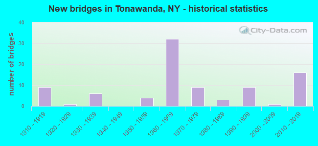
- New bridges - historical statistics
- 91910-1919
- 11920-1929
- 61930-1939
- 41950-1959
- 321960-1969
- 91970-1979
- 31980-1989
- 91990-1999
- 12000-2009
- 162010-2019

- Reconstructed bridges - Historical Statistics
- 11970-1979
- 11980-1989
- 61990-1999
- 62000-2009


- Bridge Condition - Deck
- 17.9%Excellent
- 23.1%Very good
- 30.8%Good
- 28.2%Satisfactory

- Bridge Condition - Superstructure
- 23.1%Excellent
- 17.9%Very good
- 10.3%Good
- 25.6%Satisfactory
- 20.5%Fair
- 2.6%Poor

- Bridge Condition - Substructure
- 12.8%Excellent
- 15.4%Very good
- 30.8%Good
- 17.9%Satisfactory
- 23.1%Fair

- Bridge Condition - Channel
- 5.6%Excellent
- 38.9%Very good
- 44.4%Good
- 11.1%Satisfactory

- Bridge Condition - Culverts
- 20.0%Very good
- 20.0%Good
- 60.0%Satisfactory
Find on map >> Show street view
Structure Number: 1028471, Location: JCT RT 62 + I-290 (Lat: 43.004289, Lng: -78.822436), Route carried "on" structure: Interstate 290, Year Built: 1965, Year Reconstructed: 2006, Status: Open, Structure Length: 5.36m (17.59ft), Average Daily Traffic: 53,845 (year 2012), Truck Traffic: 7%, Design Load: HS 20, Features Intersected: 62 62 53034035, RTE 62
Minimum Vertical Clearance: 30+ m (98+ ft), Kilometerpoint: 8.463, Lanes on structure: 4, Lanes under structure: 6, Base Highway Network: Yes, Owner: State Highway Agency, Approaching Roadway Width: 19.8m (65.0ft), Material/Design: Steel, Design/Construction: Stringer/Multi-beam, Number Of Spans In Main Unit: 3, Length of Maximum Span: 26.8m (87.9ft), Curb-To-Curb Width: 19.7m (64.6ft), Out-to-Out Width: 20.7m (67.9ft)
Condition: Deck: Satisfactory, Superstructure: Satisfactory, Substructure: Satisfactory, Operating Rating: 36.0 metric tons, Method Used To Determine Operating Rating: Load and Resistance Factor Rating (LRFR) rating reported by rating factor(RF) method using HL-93 loadings, Inventory Rating: 27.5 metric tons, Method Used To Determine Inventory Rating: Load and Resistance Factor Rating (LRFR) rating reported by rating factor(RF) method using HL-93 loadings, Structural Evaluation: Equal to present minimum criteria, Deck Geometry: Equal to present minimum criteria, Underclear: High priority of corrective action, Approach Roadway Alignment: Meets minimum limits, Length Of Structure Improvement: 5.36m (17.59ft), Designated Inspection Frequency: Every 24 months, Inspection Date: July 2020, Bridge Improvement Cost: $4,065,000, Roadway Improvement Cost: $2,381,000, Total Project Cost: $6,446,000 ( Estimate for 2021), Deck Structure Type: Concrete Cast-file-Place, Wearing Surface/Protective System: Wearing Surface: Monolithic Concrete
Find on map >> Show street view
Structure Number: 1028472, Location: JCT RT 62 + I-290 (Lat: 43.004078, Lng: -78.822436), Route carried "on" structure: Interstate 290, Year Built: 1965, Year Reconstructed: 2006, Status: Open, Structure Length: 5.36m (17.59ft), Average Daily Traffic: 32,043 (year 2020), Truck Traffic: 9%, Average Future Daily Traffic: 35,910 (year 2040), Design Load: HS 20, Features Intersected: 62 62 53034035, RTE 62
Minimum Vertical Clearance: 30+ m (98+ ft), Kilometerpoint: 8.463, Lanes on structure: 4, Lanes under structure: 6, Base Highway Network: Yes, Owner: State Highway Agency, Approaching Roadway Width: 19.8m (65.0ft), Material/Design: Steel, Design/Construction: Stringer/Multi-beam, Number Of Spans In Main Unit: 3, Length of Maximum Span: 26.8m (87.9ft), Curb-To-Curb Width: 19.7m (64.6ft), Out-to-Out Width: 20.7m (67.9ft)
Condition: Deck: Satisfactory, Superstructure: Satisfactory, Substructure: Fair, Operating Rating: 37.6 metric tons, Method Used To Determine Operating Rating: Load and Resistance Factor Rating (LRFR) rating reported by rating factor(RF) method using HL-93 loadings, Inventory Rating: 28.8 metric tons, Method Used To Determine Inventory Rating: Load and Resistance Factor Rating (LRFR) rating reported by rating factor(RF) method using HL-93 loadings, Structural Evaluation: Somewhat better than minimum adequacy, Deck Geometry: Equal to present minimum criteria, Underclear: High priority of corrective action, Approach Roadway Alignment: Meets minimum limits, Length Of Structure Improvement: 5.36m (17.59ft), Designated Inspection Frequency: Every 24 months, Inspection Date: July 2020, Bridge Improvement Cost: $4,065,000, Roadway Improvement Cost: $2,381,000, Total Project Cost: $6,446,000 ( Estimate for 2021), Deck Structure Type: Concrete Cast-file-Place, Wearing Surface/Protective System: Wearing Surface: Monolithic Concrete
Find on map >> Show street view
Structure Number: 102849, Location: JCT RT 62 + ELLICOTT CR. (Lat: 43.024744, Lng: -78.822217), Route carried "on" structure: US 62, Year Built: 1988, Status: Open, Structure Length: 4.85m (15.91ft), Average Daily Traffic: 29,782 (year 2020), Truck Traffic: 3%, Average Future Daily Traffic: 29,921 (year 2040), Design Load: HS 20, Features Intersected: ELLICOTT CREEK
Minimum Vertical Clearance: 30+ m (98+ ft), Kilometerpoint: 68.238, Lanes on structure: 4, Base Highway Network: Yes, Owner: State Highway Agency, Approaching Roadway Width: 21.9m (71.9ft), Material/Design: Prestressed concrete continuous, Design/Construction: Box Beam or Girders - Multiple, Number Of Spans In Main Unit: 2, Length of Maximum Span: 23.1m (75.8ft), Curb or Sidewalk Widths: Left: 1.5m (4.9ft), Right: 1.5m (4.9ft), Curb-To-Curb Width: 21.9m (71.9ft), Out-to-Out Width: 25.6m (84.0ft)
Condition: Deck: Good, Superstructure: Good, Substructure: Good, Channel: Very good, Operating Rating: 57.2 metric tons, Method Used To Determine Operating Rating: Load Factor (LF), Inventory Rating: 31.8 metric tons, Method Used To Determine Inventory Rating: Load Factor (LF), Structural Evaluation: Better than present minimum criteria, Deck Geometry: Superior to present desirable criteria, Waterway Adequacy: Equal to present minimum criteria, Approach Roadway Alignment: Equal to present desirable criteria, Length Of Structure Improvement: 4.84m (15.88ft), Designated Inspection Frequency: Every 24 months, Underwater Inspection Frequency: Every 60 months, Inspection Date: August 2021, Underwater Inspection Date: July 2017, Bridge Improvement Cost: $3,344,000, Roadway Improvement Cost: $1,958,000, Total Project Cost: $5,303,000 ( Estimate for 2021), Wearing Surface/Protective System: Wearing Surface: Integral Concrete
Find on map >> Show street view
Structure Number: 1043831, Location: JCT RT 265 + I-290 (Lat: 42.994903, Lng: -78.882856), Route carried "on" structure: Interstate 290, Year Built: 2016, Status: Open, Structure Length: 3.05m (10.01ft), Average Daily Traffic: 34,790 (year 2012), Truck Traffic: 8%, Design Load: HL 93, Features Intersected: RTE 265
Minimum Vertical Clearance: 30+ m (98+ ft), Kilometerpoint: 3.331, Lanes on structure: 3, Lanes under structure: 5, Base Highway Network: Yes, Owner: State Highway Agency, Approaching Roadway Width: 15.2m (49.9ft), Material/Design: Steel, Design/Construction: Stringer/Multi-beam, Number Of Spans In Main Unit: 1, Length of Maximum Span: 29.0m (95.1ft), Curb-To-Curb Width: 15.2m (49.9ft), Out-to-Out Width: 16.2m (53.1ft)
Condition: Deck: Excellent, Superstructure: Excellent, Substructure: Very good, Operating Rating: 52.5 metric tons, Method Used To Determine Operating Rating: Load and Resistance Factor Rating (LRFR) rating reported by rating factor(RF) method using HL-93 loadings, Inventory Rating: 40.5 metric tons, Method Used To Determine Inventory Rating: Load and Resistance Factor Rating (LRFR) rating reported by rating factor(RF) method using HL-93 loadings, Structural Evaluation: Equal to present desirable criteria, Deck Geometry: Meets minimum limits, Underclear: Somewhat better than minimum adequacy, Approach Roadway Alignment: Equal to present desirable criteria, Length Of Structure Improvement: 3.04m (9.97ft), Designated Inspection Frequency: Every 24 months, Inspection Date: August 2020, Bridge Improvement Cost: $2,819,000, Roadway Improvement Cost: $1,651,000, Total Project Cost: $4,471,000 ( Estimate for 2021), Deck Structure Type: Concrete Cast-file-Place, Wearing Surface/Protective System: Wearing Surface: Monolithic Concrete
Find on map >> Show street view
Structure Number: 1043832, Location: JCT RT 265 + I-290 (Lat: 42.994697, Lng: -78.882894), Route carried "on" structure: Interstate 290, Year Built: 2015, Status: Open, Structure Length: 3.05m (10.01ft), Average Daily Traffic: 23,598 (year 2018), Truck Traffic: 6%, Average Future Daily Traffic: 26,446 (year 2040), Design Load: HL 93, Features Intersected: RTE 265
Minimum Vertical Clearance: 30+ m (98+ ft), Kilometerpoint: 3.315, Lanes on structure: 3, Lanes under structure: 5, Base Highway Network: Yes, Owner: State Highway Agency, Approaching Roadway Width: 15.2m (49.9ft), Skew: 1 degrees, Material/Design: Steel, Design/Construction: Stringer/Multi-beam, Number Of Spans In Main Unit: 1, Length of Maximum Span: 29.0m (95.1ft), Curb-To-Curb Width: 15.2m (49.9ft), Out-to-Out Width: 16.2m (53.1ft)
Condition: Deck: Excellent, Superstructure: Excellent, Substructure: Very good, Operating Rating: 52.5 metric tons, Method Used To Determine Operating Rating: Load and Resistance Factor Rating (LRFR) rating reported by rating factor(RF) method using HL-93 loadings, Inventory Rating: 40.5 metric tons, Method Used To Determine Inventory Rating: Load and Resistance Factor Rating (LRFR) rating reported by rating factor(RF) method using HL-93 loadings, Structural Evaluation: Equal to present desirable criteria, Deck Geometry: Meets minimum limits, Underclear: Somewhat better than minimum adequacy, Approach Roadway Alignment: Equal to present desirable criteria, Length Of Structure Improvement: 3.04m (9.97ft), Designated Inspection Frequency: Every 24 months, Inspection Date: August 2020, Bridge Improvement Cost: $2,830,000, Roadway Improvement Cost: $1,657,000, Total Project Cost: $4,488,000 ( Estimate for 2021), Deck Structure Type: Concrete Cast-file-Place, Wearing Surface/Protective System: Wearing Surface: Integral Concrete, Deck Protection: Epoxy Coated Reinforcing
Find on map >> Show street view
Structure Number: 104394, Location: 0.1 MI S JCT RTS 266 +325 (Lat: 42.964597, Lng: -78.921161), Route carried "on" structure: State highway 266, Year Built: 1960, Year Reconstructed: 1999, Status: Open, Structure Length: 9.45m (31.00ft), Average Daily Traffic: 5,174 (year 2020), Truck Traffic: 12%, Average Future Daily Traffic: 5,463 (year 2040), Design Load: HS 20+Mod, Features Intersected: 190IX SB, RTE I190
Minimum Vertical Clearance: 30+ m (98+ ft), Kilometerpoint: 8.930, Lanes on structure: 4, Lanes under structure: 5, Base Highway Network: Yes, Owner: State Toll Authority, Approaching Roadway Width: 23.8m (78.1ft), Skew: 5 degrees, Material/Design: Steel, Design/Construction: Stringer/Multi-beam, Number Of Spans In Main Unit: 4, Length of Maximum Span: 28.0m (91.9ft), Curb or Sidewalk Widths: Left: 1.6m (5.2ft), Right: 1.6m (5.2ft), Curb-To-Curb Width: 18.9m (62.0ft), Out-to-Out Width: 22.7m (74.5ft)
Condition: Deck: Satisfactory, Superstructure: Fair, Substructure: Fair, Operating Rating: 76.2 metric tons, Method Used To Determine Operating Rating: Load Factor (LF), Inventory Rating: 45.4 metric tons, Method Used To Determine Inventory Rating: Load Factor (LF), Structural Evaluation: Somewhat better than minimum adequacy, Deck Geometry: Equal to present minimum criteria, Underclear: High priority of corrective action, Approach Roadway Alignment: Equal to present desirable criteria, Length Of Structure Improvement: 9.44m (30.97ft), Designated Inspection Frequency: Every 24 months, Inspection Date: April 2021, Bridge Improvement Cost: $8,243,000, Roadway Improvement Cost: $4,827,000, Total Project Cost: $13,069,000 ( Estimate for 2021), Deck Structure Type: Concrete Cast-file-Place, Wearing Surface/Protective System: Wearing Surface: Monolithic Concrete
Find on map >> Show street view
Structure Number: 104495, Location: INT N16 ON I-290 (Lat: 42.986539, Lng: -78.914228), Route carried "on" structure: Ramp Interstate 290, Year Built: 2011, Status: Open, Structure Length: 12.22m (40.09ft), Average Daily Traffic: 17,620 (year 2015), Truck Traffic: 14%, Average Future Daily Traffic: 24,668 (year 2035), Design Load: HL 93, Features Intersected: Ramp D, RTE I190, 190I X
Minimum Vertical Clearance: 30+ m (98+ ft), Kilometerpoint: 0.370, Lanes on structure: 2, Lanes under structure: 6, Owner: State Highway Agency, Approaching Roadway Width: 11.9m (39.0ft), Skew: 3 degrees, Material/Design: Steel continuous, Design/Construction: Stringer/Multi-beam, Number Of Spans In Main Unit: 2, Length of Maximum Span: 63.4m (208.0ft), Curb-To-Curb Width: 12.0m (39.4ft), Out-to-Out Width: 12.9m (42.3ft)
Condition: Deck: Very good, Superstructure: Very good, Substructure: Fair, Operating Rating: 46.3 metric tons, Method Used To Determine Operating Rating: Load and Resistance Factor Rating (LRFR) rating reported by rating factor(RF) method using HL-93 loadings, Inventory Rating: 35.6 metric tons, Method Used To Determine Inventory Rating: Load and Resistance Factor Rating (LRFR) rating reported by rating factor(RF) method using HL-93 loadings, Structural Evaluation: Somewhat better than minimum adequacy, Deck Geometry: Superior to present desirable criteria, Underclear: Meets minimum limits, Approach Roadway Alignment: Equal to present desirable criteria, Length Of Structure Improvement: 12.22m (40.09ft), Designated Inspection Frequency: Every 24 months, Inspection Date: April 2021, Bridge Improvement Cost: $6,091,000, Roadway Improvement Cost: $3,567,000, Total Project Cost: $9,659,000 ( Estimate for 2021), Deck Structure Type: Concrete Cast-file-Place, Wearing Surface/Protective System: Wearing Surface: Integral Concrete, Deck Protection: Epoxy Coated Reinforcing
Find on map >> Show street view
Structure Number: 104496, Location: INT N16 ON I-290 (Lat: 42.987092, Lng: -78.915033), Route carried "on" structure: Ramp Interstate 190, Year Built: 2011, Status: Open, Structure Length: 11.28m (37.01ft), Average Daily Traffic: 13,702 (year 2020), Truck Traffic: 15%, Average Future Daily Traffic: 15,355 (year 2040), Design Load: HL 93, Features Intersected: 190I X NB, RTE I190
Minimum Vertical Clearance: 30+ m (98+ ft), Kilometerpoint: 0.402, Lanes on structure: 2, Lanes under structure: 5, Base Highway Network: Yes, Owner: State Highway Agency, Approaching Roadway Width: 11.9m (39.0ft), Skew: 1 degrees, Material/Design: Steel continuous, Design/Construction: Stringer/Multi-beam, Number Of Spans In Main Unit: 2, Length of Maximum Span: 56.9m (186.7ft), Curb-To-Curb Width: 12.0m (39.4ft), Out-to-Out Width: 12.9m (42.3ft)
Condition: Deck: Very good, Superstructure: Very good, Substructure: Very good, Operating Rating: 56.7 metric tons, Method Used To Determine Operating Rating: Load and Resistance Factor Rating (LRFR) rating reported by rating factor(RF) method using HL-93 loadings, Inventory Rating: 43.7 metric tons, Method Used To Determine Inventory Rating: Load and Resistance Factor Rating (LRFR) rating reported by rating factor(RF) method using HL-93 loadings, Structural Evaluation: Equal to present desirable criteria, Deck Geometry: Superior to present desirable criteria, Underclear: Meets minimum limits, Approach Roadway Alignment: Equal to present desirable criteria, Length Of Structure Improvement: 11.27m (36.98ft), Designated Inspection Frequency: Every 24 months, Inspection Date: April 2021, Bridge Improvement Cost: $5,835,000, Roadway Improvement Cost: $3,417,000, Total Project Cost: $9,252,000 ( Estimate for 2021), Deck Structure Type: Concrete Cast-file-Place, Wearing Surface/Protective System: Wearing Surface: Integral Concrete, Deck Protection: Epoxy Coated Reinforcing
Find on map >> Show street view
Structure Number: 104497, Location: 1 MI N JCT SH 265 & I290 (Lat: 42.992311, Lng: -78.902019), Route carried "on" structure: County highway , Year Built: 1963, Status: Open, Structure Length: 7.99m (26.21ft), Average Daily Traffic: 2,550 (year 2020), Truck Traffic: 9%, Average Future Daily Traffic: 2,692 (year 2040), Design Load: HS 20+Mod, Features Intersected: 290I290I53011008, RTE I2, Facility Carried by Structure: TWOMILE CREEK RD
Minimum Vertical Clearance: 30+ m (98+ ft), Kilometerpoint: 2.076, Lanes on structure: 2, Lanes under structure: 6, Owner: State Highway Agency, Approaching Roadway Width: 10.4m (34.1ft), Skew: 3 degrees, Material/Design: Steel, Design/Construction: Stringer/Multi-beam, Number Of Spans In Main Unit: 4, Length of Maximum Span: 24.0m (78.7ft), Curb-To-Curb Width: 9.2m (30.2ft), Out-to-Out Width: 10.7m (35.1ft)
Condition: Deck: Satisfactory, Superstructure: Satisfactory, Substructure: Fair, Operating Rating: 62.2 metric tons, Method Used To Determine Operating Rating: Load and Resistance Factor Rating (LRFR) rating reported by rating factor(RF) method using HL-93 loadings, Inventory Rating: 48.0 metric tons, Method Used To Determine Inventory Rating: Load and Resistance Factor Rating (LRFR) rating reported by rating factor(RF) method using HL-93 loadings, Structural Evaluation: Somewhat better than minimum adequacy, Deck Geometry: Meets minimum limits, Underclear: High priority of corrective action, Approach Roadway Alignment: Somewhat better than minimum adequacy, Length Of Structure Improvement: 7.98m (26.18ft), Designated Inspection Frequency: Every 24 months, Inspection Date: July 2020, Bridge Improvement Cost: $3,047,000, Roadway Improvement Cost: $1,784,000, Total Project Cost: $4,832,000 ( Estimate for 2021), Deck Structure Type: Concrete Cast-file-Place, Wearing Surface/Protective System: Wearing Surface: Bituminous, Membrane: Other
Find on map >> Show street view
Structure Number: 104498, Location: 0.8 MI W RT 265 + I-290 (Lat: 42.992725, Lng: -78.898733), Route carried "on" structure: City street , Year Built: 1963, Status: Open, Structure Length: 6.71m (22.01ft), Average Daily Traffic: 955 (year 2019), Truck Traffic: 14%, Average Future Daily Traffic: 1,337 (year 2039), Design Load: HS 20+Mod, Features Intersected: 290 290 53011009, RTE 29, Facility Carried by Structure: EAST PARK DRIVE
Minimum Vertical Clearance: 30+ m (98+ ft), Kilometerpoint: 1.335, Lanes on structure: 2, Lanes under structure: 6, Owner: State Highway Agency, Approaching Roadway Width: 10.1m (33.1ft), Skew: 1 degrees, Material/Design: Steel, Design/Construction: Stringer/Multi-beam, Number Of Spans In Main Unit: 4, Length of Maximum Span: 20.1m (65.9ft), Curb-To-Curb Width: 9.2m (30.2ft), Out-to-Out Width: 10.8m (35.4ft)
Condition: Deck: Satisfactory, Superstructure: Fair, Substructure: Satisfactory, Operating Rating: 52.8 metric tons, Method Used To Determine Operating Rating: Load and Resistance Factor Rating (LRFR) rating reported by rating factor(RF) method using HL-93 loadings, Inventory Rating: 40.5 metric tons, Method Used To Determine Inventory Rating: Load and Resistance Factor Rating (LRFR) rating reported by rating factor(RF) method using HL-93 loadings, Structural Evaluation: Somewhat better than minimum adequacy, Deck Geometry: Equal to present minimum criteria, Underclear: High priority of corrective action, Approach Roadway Alignment: Somewhat better than minimum adequacy, Length Of Structure Improvement: 6.70m (21.98ft), Designated Inspection Frequency: Every 24 months, Inspection Date: July 2020, Bridge Improvement Cost: $2,581,000, Roadway Improvement Cost: $1,511,000, Total Project Cost: $4,092,000 ( Estimate for 2021), Deck Structure Type: Concrete Cast-file-Place, Wearing Surface/Protective System: Wearing Surface: Bituminous, Membrane: Other
Find on map >> Show street view
Structure Number: 1044991, Location: 0.1 MI W RT 265 + I-290 (Lat: 42.994667, Lng: -78.885317), Route carried "on" structure: Interstate 290, Year Built: 1965, Year Reconstructed: 2006, Status: Open, Structure Length: 5.76m (18.90ft), Average Daily Traffic: 34,790 (year 2012), Truck Traffic: 8%, Features Intersected: CSX TRANS/AMTRAK
Minimum Vertical Clearance: 30+ m (98+ ft), Kilometerpoint: 3.121, Lanes on structure: 3, Base Highway Network: Yes, Owner: State Highway Agency, Approaching Roadway Width: 12.8m (42.0ft), Material/Design: Steel, Design/Construction: Stringer/Multi-beam, Number Of Spans In Main Unit: 3, Length of Maximum Span: 24.0m (78.7ft), Curb-To-Curb Width: 12.8m (42.0ft), Out-to-Out Width: 13.7m (44.9ft)
Condition: Deck: Good, Superstructure: Fair, Substructure: Good, Operating Rating: 65.3 metric tons, Method Used To Determine Operating Rating: Load Factor (LF), Inventory Rating: 39.0 metric tons, Method Used To Determine Inventory Rating: Load Factor (LF), Structural Evaluation: Somewhat better than minimum adequacy, Deck Geometry: High priority of replacement, Underclear: Somewhat better than minimum adequacy, Approach Roadway Alignment: Somewhat better than minimum adequacy, Length Of Structure Improvement: 5.76m (18.90ft), Designated Inspection Frequency: Every 24 months, Inspection Date: December 2020, Bridge Improvement Cost: $2,865,000, Roadway Improvement Cost: $1,678,000, Total Project Cost: $4,542,000 ( Estimate for 2021), Deck Structure Type: Concrete Cast-file-Place, Wearing Surface/Protective System: Wearing Surface: Monolithic Concrete
Find on map >> Show street view
Structure Number: 1044992, Location: 0.1 MI W RT 265 + I-290 (Lat: 42.994458, Lng: -78.885364), Route carried "on" structure: Interstate 290, Year Built: 1965, Status: Open, Structure Length: 6.10m (20.01ft), Average Daily Traffic: 23,598 (year 2018), Truck Traffic: 6%, Average Future Daily Traffic: 26,446 (year 2040), Features Intersected: CSX TRANS/AMTRAK
Minimum Vertical Clearance: 30+ m (98+ ft), Kilometerpoint: 3.105, Lanes on structure: 3, Base Highway Network: Yes, Owner: State Highway Agency, Approaching Roadway Width: 12.8m (42.0ft), Material/Design: Steel, Design/Construction: Stringer/Multi-beam, Number Of Spans In Main Unit: 3, Length of Maximum Span: 27.4m (89.9ft), Curb-To-Curb Width: 12.8m (42.0ft), Out-to-Out Width: 13.7m (44.9ft)
Condition: Deck: Satisfactory, Superstructure: Fair, Substructure: Good, Operating Rating: 75.3 metric tons, Method Used To Determine Operating Rating: Load Factor (LF), Inventory Rating: 45.4 metric tons, Method Used To Determine Inventory Rating: Load Factor (LF), Structural Evaluation: Somewhat better than minimum adequacy, Deck Geometry: Meets minimum limits, Underclear: Somewhat better than minimum adequacy, Approach Roadway Alignment: Somewhat better than minimum adequacy, Length Of Structure Improvement: 6.09m (19.98ft), Designated Inspection Frequency: Every 24 months, Inspection Date: December 2020, Bridge Improvement Cost: $3,019,000, Roadway Improvement Cost: $1,768,000, Total Project Cost: $4,788,000 ( Estimate for 2021), Deck Structure Type: Concrete Cast-file-Place, Wearing Surface/Protective System: Wearing Surface: Monolithic Concrete
Find on map >> Show street view
Structure Number: 1045001, Location: JCT RT 384 + I-290 (Lat: 42.995669, Lng: -78.874481), Route carried "on" structure: Interstate 290, Year Built: 2016, Status: Open, Structure Length: 5.94m (19.49ft), Average Daily Traffic: 45,081 (year 2012), Truck Traffic: 8%, Design Load: HS 20+Mod, Features Intersected: RTE 384
Minimum Vertical Clearance: 30+ m (98+ ft), Kilometerpoint: 4.023, Lanes on structure: 4, Lanes under structure: 6, Base Highway Network: Yes, Owner: State Highway Agency, Approaching Roadway Width: 19.8m (65.0ft), Material/Design: Steel continuous, Design/Construction: Stringer/Multi-beam, Number Of Spans In Main Unit: 3, Length of Maximum Span: 30.8m (101.0ft), Curb-To-Curb Width: 19.8m (65.0ft), Out-to-Out Width: 20.7m (67.9ft)
Condition: Deck: Excellent, Superstructure: Excellent, Substructure: Excellent, Inventory Rating: 65.3 metric tons, Method Used To Determine Inventory Rating: Load Factor (LF), Structural Evaluation: Superior to present desirable criteria, Deck Geometry: Equal to present minimum criteria, Underclear: High priority of corrective action, Approach Roadway Alignment: Better than present minimum criteria, Length Of Structure Improvement: 5.94m (19.49ft), Designated Inspection Frequency: Every 24 months, Inspection Date: April 2020, Bridge Improvement Cost: $4,451,000, Roadway Improvement Cost: $2,606,000, Total Project Cost: $7,057,000 ( Estimate for 2021), Deck Structure Type: Concrete Cast-file-Place, Wearing Surface/Protective System: Wearing Surface: Integral Concrete
Find on map >> Show street view
Structure Number: 1045002, Location: JCT RT 384 + I-290 (Lat: 42.995442, Lng: -78.874450), Route carried "on" structure: Interstate 290, Year Built: 2015, Status: Open, Structure Length: 5.94m (19.49ft), Average Daily Traffic: 30,714 (year 2019), Truck Traffic: 7%, Average Future Daily Traffic: 34,421 (year 2040), Design Load: HL 93, Features Intersected: RTE 384
Minimum Vertical Clearance: 30+ m (98+ ft), Kilometerpoint: 4.023, Lanes on structure: 3, Lanes under structure: 7, Base Highway Network: Yes, Owner: State Highway Agency, Approaching Roadway Width: 15.2m (49.9ft), Material/Design: Steel continuous, Design/Construction: Stringer/Multi-beam, Number Of Spans In Main Unit: 3, Length of Maximum Span: 30.8m (101.0ft), Curb-To-Curb Width: 15.2m (49.9ft), Out-to-Out Width: 16.2m (53.1ft)
Condition: Deck: Excellent, Superstructure: Excellent, Substructure: Excellent, Inventory Rating: 66.2 metric tons, Method Used To Determine Inventory Rating: Load Factor (LF), Structural Evaluation: Superior to present desirable criteria, Deck Geometry: Meets minimum limits, Underclear: High priority of corrective action, Approach Roadway Alignment: Better than present minimum criteria, Length Of Structure Improvement: 5.94m (19.49ft), Designated Inspection Frequency: Every 24 months, Inspection Date: April 2020, Bridge Improvement Cost: $3,469,000, Roadway Improvement Cost: $2,032,000, Total Project Cost: $5,501,000 ( Estimate for 2021), Deck Structure Type: Concrete Cast-file-Place, Wearing Surface/Protective System: Wearing Surface: Integral Concrete, Deck Protection: Epoxy Coated Reinforcing
Find on map >> Show street view
Structure Number: 1045011, Location: .8 MI E JCT SH 384 & I290 (Lat: 42.997139, Lng: -78.858725), Route carried "on" structure: Interstate 290, Year Built: 2019, Status: Open, Structure Length: 4.21m (13.81ft), Average Daily Traffic: 45,081 (year 2012), Truck Traffic: 8%, Design Load: HL 93, Features Intersected: NFTA - OUT OF SVC
Minimum Vertical Clearance: 30+ m (98+ ft), Kilometerpoint: 5.342, Lanes on structure: 3, Base Highway Network: Yes, Owner: State Highway Agency, Approaching Roadway Width: 15.2m (49.9ft), Material/Design: Steel, Design/Construction: Stringer/Multi-beam, Number Of Spans In Main Unit: 1, Length of Maximum Span: 41.8m (137.1ft), Curb-To-Curb Width: 15.2m (49.9ft), Out-to-Out Width: 16.2m (53.1ft)
Condition: Deck: Excellent, Superstructure: Excellent, Substructure: Excellent, Operating Rating: 50.9 metric tons, Method Used To Determine Operating Rating: Load and Resistance Factor Rating (LRFR) rating reported by rating factor(RF) method using HL-93 loadings, Inventory Rating: 39.2 metric tons, Method Used To Determine Inventory Rating: Load and Resistance Factor Rating (LRFR) rating reported by rating factor(RF) method using HL-93 loadings, Structural Evaluation: Superior to present desirable criteria, Deck Geometry: Meets minimum limits, Approach Roadway Alignment: Better than present minimum criteria, Length Of Structure Improvement: 4.20m (13.78ft), Designated Inspection Frequency: Every 24 months, Inspection Date: July 2020, Bridge Improvement Cost: $2,697,000, Roadway Improvement Cost: $1,579,000, Total Project Cost: $4,276,000 ( Estimate for 2021), Deck Structure Type: Concrete Cast-file-Place, Wearing Surface/Protective System: Wearing Surface: Integral Concrete, Deck Protection: Epoxy Coated Reinforcing
Find on map >> Show street view
Structure Number: 1045012, Location: .8 MI E JCT SH 384 & I290 (Lat: 42.996972, Lng: -78.858486), Route carried "on" structure: Interstate 290, Year Built: 2018, Status: Open, Structure Length: 4.30m (14.11ft), Average Daily Traffic: 30,714 (year 2019), Truck Traffic: 7%, Average Future Daily Traffic: 34,421 (year 2040), Design Load: HS 20, Features Intersected: NFTA - OUT OF SVC
Minimum Vertical Clearance: 30+ m (98+ ft), Kilometerpoint: 5.342, Lanes on structure: 3, Base Highway Network: Yes, Owner: State Highway Agency, Approaching Roadway Width: 15.2m (49.9ft), Material/Design: Steel continuous, Design/Construction: Girder and Floorbeam System, Number Of Spans In Main Unit: 1, Length of Maximum Span: 42.7m (140.1ft), Curb-To-Curb Width: 15.2m (49.9ft), Out-to-Out Width: 16.2m (53.1ft)
Condition: Deck: Excellent, Superstructure: Excellent, Substructure: Excellent, Operating Rating: 69.9 metric tons, Method Used To Determine Operating Rating: Load Factor (LF), Inventory Rating: 41.7 metric tons, Method Used To Determine Inventory Rating: Load Factor (LF), Structural Evaluation: Superior to present desirable criteria, Deck Geometry: Meets minimum limits, Approach Roadway Alignment: Equal to present desirable criteria, Length Of Structure Improvement: 4.29m (14.07ft), Designated Inspection Frequency: Every 24 months, Inspection Date: July 2020, Bridge Improvement Cost: $2,617,000, Roadway Improvement Cost: $1,533,000, Total Project Cost: $4,150,000 ( Estimate for 2021), Deck Structure Type: Concrete Cast-file-Place, Wearing Surface/Protective System: Wearing Surface: Integral Concrete, Deck Protection: Epoxy Coated Reinforcing
Find on map >> Show street view
Structure Number: 1045021, Location: 1.2 MI E JCT RT 384 +I290 (Lat: 43.000017, Lng: -78.853078), Route carried "on" structure: Interstate 290, Year Built: 1963, Status: Open, Structure Length: 5.67m (18.60ft), Average Daily Traffic: 47,393 (year 2012), Truck Traffic: 7%, Design Load: HS 20+Mod, Features Intersected: RTE 425, 425 950H530110
Minimum Vertical Clearance: 30+ m (98+ ft), Kilometerpoint: 5.905, Lanes on structure: 3, Lanes under structure: 7, Base Highway Network: Yes, Owner: State Highway Agency, Approaching Roadway Width: 12.8m (42.0ft), Material/Design: Steel, Design/Construction: Stringer/Multi-beam, Number Of Spans In Main Unit: 4, Length of Maximum Span: 16.4m (53.8ft), Curb-To-Curb Width: 12.8m (42.0ft), Out-to-Out Width: 13.7m (44.9ft)
Condition: Deck: Good, Superstructure: Satisfactory, Substructure: Satisfactory, Operating Rating: 42.1 metric tons, Method Used To Determine Operating Rating: Load and Resistance Factor Rating (LRFR) rating reported by rating factor(RF) method using HL-93 loadings, Inventory Rating: 32.4 metric tons, Method Used To Determine Inventory Rating: Load and Resistance Factor Rating (LRFR) rating reported by rating factor(RF) method using HL-93 loadings, Structural Evaluation: Equal to present minimum criteria, Deck Geometry: High priority of replacement, Underclear: High priority of corrective action, Approach Roadway Alignment: Equal to present minimum criteria, Length Of Structure Improvement: 5.66m (18.57ft), Designated Inspection Frequency: Every 24 months, Inspection Date: July 2020, Bridge Improvement Cost: $2,826,000, Roadway Improvement Cost: $1,655,000, Total Project Cost: $4,480,000 ( Estimate for 2021), Deck Structure Type: Concrete Cast-file-Place, Wearing Surface/Protective System: Wearing Surface: Monolithic Concrete
Find on map >> Show street view
Structure Number: 1045022, Location: 1.2 MI E JCT RT 384 +I290 (Lat: 42.999831, Lng: -78.852978), Route carried "on" structure: Interstate 290, Year Built: 1963, Status: Open, Structure Length: 5.67m (18.60ft), Average Daily Traffic: 32,043 (year 2020), Truck Traffic: 9%, Average Future Daily Traffic: 35,910 (year 2040), Design Load: HS 20+Mod, Features Intersected: RTE 425, COLVIN AVENUE
Minimum Vertical Clearance: 30+ m (98+ ft), Kilometerpoint: 5.905, Lanes on structure: 3, Lanes under structure: 7, Base Highway Network: Yes, Owner: State Highway Agency, Approaching Roadway Width: 16.5m (54.1ft), Material/Design: Steel, Design/Construction: Stringer/Multi-beam, Number Of Spans In Main Unit: 4, Length of Maximum Span: 16.4m (53.8ft), Curb-To-Curb Width: 16.5m (54.1ft), Out-to-Out Width: 17.4m (57.1ft)
Condition: Deck: Good, Superstructure: Satisfactory, Substructure: Satisfactory, Operating Rating: 39.5 metric tons, Method Used To Determine Operating Rating: Load and Resistance Factor Rating (LRFR) rating reported by rating factor(RF) method using HL-93 loadings, Inventory Rating: 30.5 metric tons, Method Used To Determine Inventory Rating: Load and Resistance Factor Rating (LRFR) rating reported by rating factor(RF) method using HL-93 loadings, Structural Evaluation: Equal to present minimum criteria, Deck Geometry: Equal to present minimum criteria, Underclear: High priority of corrective action, Approach Roadway Alignment: Equal to present minimum criteria, Length Of Structure Improvement: 5.66m (18.57ft), Designated Inspection Frequency: Every 24 months, Inspection Date: July 2020, Bridge Improvement Cost: $3,585,000, Roadway Improvement Cost: $2,100,000, Total Project Cost: $5,685,000 ( Estimate for 2021), Deck Structure Type: Concrete Cast-file-Place, Wearing Surface/Protective System: Wearing Surface: Monolithic Concrete
Find on map >> Show street view
Structure Number: 1045031, Location: 0.8 MI W JCT RT 384 + 62 (Lat: 43.001375, Lng: -78.836283), Route carried "on" structure: Interstate 290, Year Built: 1965, Year Reconstructed: 2006, Status: Open, Structure Length: 4.21m (13.81ft), Average Daily Traffic: 47,393 (year 2012), Truck Traffic: 7%, Design Load: HS 20+Mod, Features Intersected: PARKER BLVD
Minimum Vertical Clearance: 30+ m (98+ ft), Kilometerpoint: 7.289, Lanes on structure: 3, Lanes under structure: 2, Base Highway Network: Yes, Owner: State Highway Agency, Approaching Roadway Width: 12.8m (42.0ft), Skew: 1 degrees, Material/Design: Steel, Design/Construction: Stringer/Multi-beam, Number Of Spans In Main Unit: 3, Length of Maximum Span: 18.8m (61.7ft), Curb-To-Curb Width: 12.8m (42.0ft), Out-to-Out Width: 13.7m (44.9ft)
Condition: Deck: Good, Superstructure: Very good, Substructure: Good, Operating Rating: 52.5 metric tons, Method Used To Determine Operating Rating: Load and Resistance Factor Rating (LRFR) rating reported by rating factor(RF) method using HL-93 loadings, Inventory Rating: 40.5 metric tons, Method Used To Determine Inventory Rating: Load and Resistance Factor Rating (LRFR) rating reported by rating factor(RF) method using HL-93 loadings, Structural Evaluation: Better than present minimum criteria, Deck Geometry: High priority of replacement, Underclear: Somewhat better than minimum adequacy, Approach Roadway Alignment: Equal to present minimum criteria, Length Of Structure Improvement: 4.20m (13.78ft), Designated Inspection Frequency: Every 24 months, Inspection Date: October 2020, Bridge Improvement Cost: $2,186,000, Roadway Improvement Cost: $1,280,000, Total Project Cost: $3,467,000 ( Estimate for 2021), Deck Structure Type: Concrete Cast-file-Place, Wearing Surface/Protective System: Wearing Surface: Monolithic Concrete
Find on map >> Show street view
Structure Number: 1045032, Location: .8 MI W JCT I290 & US 62 (Lat: 43.001172, Lng: -78.836292), Route carried "on" structure: Interstate 290, Year Built: 1965, Year Reconstructed: 2006, Status: Open, Structure Length: 4.21m (13.81ft), Average Daily Traffic: 32,043 (year 2020), Truck Traffic: 9%, Average Future Daily Traffic: 35,910 (year 2040), Design Load: HS 20+Mod, Features Intersected: PARKER BOULEVARD
Minimum Vertical Clearance: 30+ m (98+ ft), Kilometerpoint: 7.289, Lanes on structure: 3, Lanes under structure: 2, Base Highway Network: Yes, Owner: State Highway Agency, Approaching Roadway Width: 12.8m (42.0ft), Skew: 1 degrees, Material/Design: Steel, Design/Construction: Stringer/Multi-beam, Number Of Spans In Main Unit: 3, Length of Maximum Span: 18.8m (61.7ft), Curb-To-Curb Width: 12.8m (42.0ft), Out-to-Out Width: 13.7m (44.9ft)
Condition: Deck: Good, Superstructure: Very good, Substructure: Good, Operating Rating: 52.2 metric tons, Method Used To Determine Operating Rating: Load and Resistance Factor Rating (LRFR) rating reported by rating factor(RF) method using HL-93 loadings, Inventory Rating: 40.2 metric tons, Method Used To Determine Inventory Rating: Load and Resistance Factor Rating (LRFR) rating reported by rating factor(RF) method using HL-93 loadings, Structural Evaluation: Better than present minimum criteria, Deck Geometry: High priority of replacement, Underclear: Somewhat better than minimum adequacy, Approach Roadway Alignment: Equal to present minimum criteria, Length Of Structure Improvement: 4.20m (13.78ft), Designated Inspection Frequency: Every 24 months, Inspection Date: October 2020, Bridge Improvement Cost: $2,131,000, Roadway Improvement Cost: $1,248,000, Total Project Cost: $3,380,000 ( Estimate for 2021), Deck Structure Type: Concrete Cast-file-Place, Wearing Surface/Protective System: Wearing Surface: Monolithic Concrete
Find on map >> Show street view
Structure Number: 1046551, Location: 1.6 KM NW JCT RT 425&290I (Lat: 43.012394, Lng: -78.863117), Route carried "on" structure: State highway 425, Year Built: 1965, Year Reconstructed: 1998, Status: Open, Structure Length: 10.67m (35.01ft), Average Daily Traffic: 9,825 (year 2020), Truck Traffic: 5%, Average Future Daily Traffic: 11,385 (year 2040), Design Load: HS 25 or greater, Features Intersected: ELLICOTT CREEK RD, ELLIC
Minimum Vertical Clearance: 30+ m (98+ ft), Kilometerpoint: 1.754, Lanes on structure: 2, Lanes under structure: 2, Base Highway Network: Yes, Owner: State Highway Agency, Approaching Roadway Width: 11.0m (36.1ft), Material/Design: Steel continuous, Design/Construction: Stringer/Multi-beam, Number Of Spans In Main Unit: 5, Length of Maximum Span: 24.3m (79.7ft), Curb-To-Curb Width: 9.6m (31.5ft), Out-to-Out Width: 10.5m (34.4ft)
Condition: Deck: Good, Superstructure: Good, Substructure: Satisfactory, Channel: Very good, Operating Rating: 76.2 metric tons, Method Used To Determine Operating Rating: Load Factor (LF), Inventory Rating: 46.3 metric tons, Method Used To Determine Inventory Rating: Load Factor (LF), Structural Evaluation: Equal to present minimum criteria, Deck Geometry: Meets minimum limits, Underclear: High priority of corrective action, Waterway Adequacy: Superior to present desirable criteria, Approach Roadway Alignment: Equal to present desirable criteria, Length Of Structure Improvement: 10.66m (34.97ft), Designated Inspection Frequency: Every 24 months, Underwater Inspection Frequency: Every 60 months, Inspection Date: May 2021, Underwater Inspection Date: August 2019, Bridge Improvement Cost: $3,808,000, Roadway Improvement Cost: $2,230,000, Total Project Cost: $6,038,000 ( Estimate for 2021), Deck Structure Type: Concrete Cast-file-Place, Wearing Surface/Protective System: Wearing Surface: Integral Concrete, Deck Protection: Epoxy Coated Reinforcing
Find on map >> Show street view
Structure Number: 1046552, Location: 1.6 KM NW JCT RT 425&290I (Lat: 43.012336, Lng: -78.862897), Route carried "on" structure: State highway 425, Year Built: 1965, Year Reconstructed: 1997, Status: Open, Structure Length: 10.24m (33.60ft), Average Daily Traffic: 9,825 (year 2020), Truck Traffic: 5%, Average Future Daily Traffic: 11,385 (year 2040), Design Load: HS 25 or greater, Features Intersected: ELLICOTT CREEK RD, ELLIC
Minimum Vertical Clearance: 30+ m (98+ ft), Kilometerpoint: 1.754, Lanes on structure: 2, Lanes under structure: 2, Base Highway Network: Yes, Owner: State Highway Agency, Approaching Roadway Width: 11.0m (36.1ft), Material/Design: Steel continuous, Design/Construction: Stringer/Multi-beam, Number Of Spans In Main Unit: 5, Length of Maximum Span: 24.0m (78.7ft), Curb-To-Curb Width: 9.6m (31.5ft), Out-to-Out Width: 10.5m (34.4ft)
Condition: Deck: Satisfactory, Superstructure: Good, Substructure: Satisfactory, Operating Rating: 75.3 metric tons, Method Used To Determine Operating Rating: Load Factor (LF), Inventory Rating: 44.5 metric tons, Method Used To Determine Inventory Rating: Load Factor (LF), Structural Evaluation: Equal to present minimum criteria, Deck Geometry: Meets minimum limits, Underclear: High priority of corrective action, Waterway Adequacy: Superior to present desirable criteria, Approach Roadway Alignment: Equal to present desirable criteria, Length Of Structure Improvement: 10.24m (33.60ft), Designated Inspection Frequency: Every 24 months, Underwater Inspection Frequency: Every 60 months, Inspection Date: May 2021, Underwater Inspection Date: August 2019, Bridge Improvement Cost: $3,664,000, Roadway Improvement Cost: $2,146,000, Total Project Cost: $5,809,000 ( Estimate for 2021), Deck Structure Type: Concrete Cast-file-Place, Wearing Surface/Protective System: Wearing Surface: Integral Concrete, Deck Protection: Epoxy Coated Reinforcing
Find on map >> Show street view
Structure Number: 1050691, Location: 1.4 MI NW JCT SH425& I290 (Lat: 43.019542, Lng: -78.861408), Route carried "on" structure: State highway 425, Year Built: 1970, Year Reconstructed: 2003, Status: Open, Structure Length: 4.39m (14.40ft), Average Daily Traffic: 9,541 (year 2020), Truck Traffic: 3%, Average Future Daily Traffic: 11,055 (year 2040), Design Load: HS 20, Features Intersected: CSX TRANSPORTATION
Minimum Vertical Clearance: 30+ m (98+ ft), Kilometerpoint: 2.590, Lanes on structure: 3, Base Highway Network: Yes, Owner: State Highway Agency, Approaching Roadway Width: 16.8m (55.1ft), Material/Design: Steel, Design/Construction: Stringer/Multi-beam, Number Of Spans In Main Unit: 3, Length of Maximum Span: 14.0m (45.9ft), Curb-To-Curb Width: 13.9m (45.6ft), Out-to-Out Width: 14.8m (48.6ft)
Condition: Deck: Good, Superstructure: Fair, Substructure: Fair, Operating Rating: 74.4 metric tons, Method Used To Determine Operating Rating: Load Factor (LF), Inventory Rating: 44.5 metric tons, Method Used To Determine Inventory Rating: Load Factor (LF), Structural Evaluation: Somewhat better than minimum adequacy, Deck Geometry: Meets minimum limits, Underclear: Better than present minimum criteria, Approach Roadway Alignment: Equal to present minimum criteria, Length Of Structure Improvement: 4.38m (14.37ft), Designated Inspection Frequency: Every 24 months, Inspection Date: December 2020, Bridge Improvement Cost: $2,407,000, Roadway Improvement Cost: $1,409,000, Total Project Cost: $3,816,000 ( Estimate for 2021), Deck Structure Type: Concrete Cast-file-Place, Wearing Surface/Protective System: Wearing Surface: Monolithic Concrete
Find on map >> Show street view
Structure Number: 1050692, Location: 1.4 MI NW JCT SH425& I290 (Lat: 43.019503, Lng: -78.861147), Route carried "on" structure: State highway 425, Year Built: 1970, Year Reconstructed: 2003, Status: Open, Structure Length: 4.39m (14.40ft), Average Daily Traffic: 9,541 (year 2020), Truck Traffic: 3%, Average Future Daily Traffic: 11,055 (year 2040), Design Load: HS 20, Features Intersected: CSX TRANSPORTATION
Minimum Vertical Clearance: 30+ m (98+ ft), Kilometerpoint: 2.590, Lanes on structure: 3, Base Highway Network: Yes, Owner: State Highway Agency, Approaching Roadway Width: 16.8m (55.1ft), Material/Design: Steel, Design/Construction: Stringer/Multi-beam, Number Of Spans In Main Unit: 3, Length of Maximum Span: 14.0m (45.9ft), Curb-To-Curb Width: 13.9m (45.6ft), Out-to-Out Width: 14.8m (48.6ft)
Condition: Deck: Good, Superstructure: Fair, Substructure: Fair, Operating Rating: 74.4 metric tons, Method Used To Determine Operating Rating: Load Factor (LF), Inventory Rating: 44.5 metric tons, Method Used To Determine Inventory Rating: Load Factor (LF), Structural Evaluation: Somewhat better than minimum adequacy, Deck Geometry: Meets minimum limits, Underclear: Better than present minimum criteria, Approach Roadway Alignment: Equal to present minimum criteria, Length Of Structure Improvement: 4.38m (14.37ft), Designated Inspection Frequency: Every 24 months, Inspection Date: December 2020, Bridge Improvement Cost: $2,407,000, Roadway Improvement Cost: $1,409,000, Total Project Cost: $3,816,000 ( Estimate for 2021), Deck Structure Type: Concrete Cast-file-Place, Wearing Surface/Protective System: Wearing Surface: Monolithic Concrete
Find on map >> Show street view
Structure Number: 20473, Location: 1.7 MI N JCT RT 384 &I290 (Lat: 43.020111, Lng: -78.875061), Route carried "on" structure: State highway 384, Year Built: 2001, Status: Open, Structure Length: 4.18m (13.71ft), Average Daily Traffic: 8,461 (year 2019), Truck Traffic: 4%, Average Future Daily Traffic: 8,500 (year 2040), Design Load: HS 25 or greater, Features Intersected: ELLICOTT CREEK
Minimum Vertical Clearance: 30+ m (98+ ft), Kilometerpoint: 15.543, Lanes on structure: 4, Base Highway Network: Yes, Owner: City or Municipal Highway Agency, Approaching Roadway Width: 13.7m (44.9ft), Skew: 2 degrees, Material/Design: Steel, Design/Construction: Stringer/Multi-beam, Number Of Spans In Main Unit: 1, Length of Maximum Span: 40.2m (131.9ft), Curb or Sidewalk Widths: Left: 1.4m (4.6ft), Right: 1.4m (4.6ft), Curb-To-Curb Width: 13.8m (45.3ft), Out-to-Out Width: 17.4m (57.1ft)
Condition: Deck: Satisfactory, Superstructure: Good, Substructure: Good, Channel: Excellent, Operating Rating: 70.8 metric tons, Method Used To Determine Operating Rating: Load Factor (LF), Inventory Rating: 46.3 metric tons, Method Used To Determine Inventory Rating: Load Factor (LF), Structural Evaluation: Better than present minimum criteria, Deck Geometry: High priority of replacement, Waterway Adequacy: Superior to present desirable criteria, Approach Roadway Alignment: Equal to present minimum criteria, Length Of Structure Improvement: 4.17m (13.68ft), Designated Inspection Frequency: Every 24 months, Inspection Date: November 2021, Bridge Improvement Cost: $3,142,000, Roadway Improvement Cost: $1,840,000, Total Project Cost: $4,982,000 ( Estimate for 2021), Deck Structure Type: Concrete Cast-file-Place, Wearing Surface/Protective System: Wearing Surface: Monolithic Concrete, Deck Protection: Epoxy Coated Reinforcing
Find on map >> Show street view
Structure Number: 226048, Location: 0.960KM NW 425+ELLICOT CR (Lat: 43.017097, Lng: -78.871144), Route carried "on" structure: City street , Year Built: 1998, Status: Open, Structure Length: 2.96m (9.71ft), Average Daily Traffic: 2,022 (year 2019), Truck Traffic: 8%, Average Future Daily Traffic: 2,831 (year 2039), Design Load: HS 25 or greater, Features Intersected: ELLICOTT CREEK, Facility Carried by Structure: FREMONT STREET
Minimum Vertical Clearance: 30+ m (98+ ft), Kilometerpoint: 0.000, Lanes on structure: 2, Owner: City or Municipal Highway Agency, Approaching Roadway Width: 8.2m (26.9ft), Material/Design: Steel, Design/Construction: Stringer/Multi-beam, Number Of Spans In Main Unit: 1, Length of Maximum Span: 28.3m (92.8ft), Curb or Sidewalk Widths: Left: 0.0m, Right: 1.5m (4.9ft), Curb-To-Curb Width: 8.4m (27.6ft), Out-to-Out Width: 11.2m (36.7ft)
Condition: Deck: Very good, Superstructure: Very good, Substructure: Very good, Channel: Good, Operating Rating: 91.6 metric tons, Method Used To Determine Operating Rating: Load Factor (LF), Inventory Rating: 54.4 metric tons, Method Used To Determine Inventory Rating: Load Factor (LF), Structural Evaluation: Equal to present desirable criteria, Deck Geometry: High priority of corrective action, Waterway Adequacy: Equal to present minimum criteria, Approach Roadway Alignment: Meets minimum limits, Length Of Structure Improvement: 2.95m (9.68ft), Designated Inspection Frequency: Every 24 months, Inspection Date: August 2020, Bridge Improvement Cost: $1,705,000, Roadway Improvement Cost: $998,000, Total Project Cost: $2,703,000 ( Estimate for 2021), Deck Structure Type: Concrete Cast-file-Place, Wearing Surface/Protective System: Wearing Surface: Monolithic Concrete, Deck Protection: Epoxy Coated Reinforcing
Find on map >> Show street view
Structure Number: 226051, Location: 1.9 MI SW JCT 265'266 (Lat: 43.004703, Lng: -78.905683), Route carried "on" structure: City street , Year Built: 1960, Status: Open, Structure Length: 1.01m (3.31ft), Average Daily Traffic: 1,239 (year 2017), Truck Traffic: 3%, Average Future Daily Traffic: 1,735 (year 2037), Features Intersected: TWO MILE CREEK, Facility Carried by Structure: FLETCHER STREET
Minimum Vertical Clearance: 30+ m (98+ ft), Kilometerpoint: 3.073, Lanes on structure: 2, Owner: City or Municipal Highway Agency, Approaching Roadway Width: 7.6m (24.9ft), Material/Design: Concrete continuous, Design/Construction: Culvert, Number Of Spans In Main Unit: 2, Length of Maximum Span: 4.5m (14.8ft), Curb or Sidewalk Widths: Left: 2.6m (8.5ft), Right: 0.0m
Condition: Channel: Satisfactory, Culverts: Satisfactory, Operating Rating: 75.5 metric tons, Method Used To Determine Operating Rating: Field evaluation and documented engineering judgment, Inventory Rating: 29.4 metric tons, Method Used To Determine Inventory Rating: Field evaluation and documented engineering judgment, Structural Evaluation: Equal to present minimum criteria, Waterway Adequacy: Meets minimum limits, Approach Roadway Alignment: Equal to present minimum criteria, Length Of Structure Improvement: 1.00m (3.28ft), Designated Inspection Frequency: Every 24 months, Inspection Date: July 2020, Bridge Improvement Cost: $212,000, Roadway Improvement Cost: $124,000, Total Project Cost: $336,000 ( Estimate for 2021), Wearing Surface/Protective System: Wearing Surface: Bituminous
Find on map >> Show street view
Structure Number: 227115, Location: Tonawanda (Lat: 42.996061, Lng: -78.900375), Route carried "on" structure: Other road , Year Built: 2015, Status: Open, Structure Length: 3.11m (10.20ft), Average Daily Traffic: 392 (year 2020), Truck Traffic: 11%, Average Future Daily Traffic: 549 (year 2040), Design Load: HL 93, Features Intersected: Two Mile Creek, Greenway, Facility Carried by Structure: Pirson Parkway
Minimum Vertical Clearance: 30+ m (98+ ft), Kilometerpoint: 0.080, Lanes on structure: 2, Owner: Town or Township Highway Agency, Approaching Roadway Width: 9.8m (32.2ft), Material/Design: Steel, Design/Construction: Truss - Thru, Number Of Spans In Main Unit: 1, Length of Maximum Span: 30.5m (100.1ft), Curb-To-Curb Width: 9.8m (32.2ft), Out-to-Out Width: 11.9m (39.0ft)
Condition: Deck: Excellent, Superstructure: Very good, Substructure: Very good, Channel: Good, Operating Rating: 83.5 metric tons, Method Used To Determine Operating Rating: Load Factor (LF), Inventory Rating: 49.9 metric tons, Method Used To Determine Inventory Rating: Load Factor (LF), Structural Evaluation: Equal to present desirable criteria, Deck Geometry: Better than present minimum criteria, Waterway Adequacy: Equal to present minimum criteria, Approach Roadway Alignment: Equal to present desirable criteria, Length Of Structure Improvement: 3.10m (10.17ft), Designated Inspection Frequency: Every 24 months, Critical Feature Inspection Frequency: Every 24 months, Inspection Date: April 2020, Critical Feature Inspection Date: April 2020, Bridge Improvement Cost: $2,990,000, Roadway Improvement Cost: $1,751,000, Total Project Cost: $4,740,000 ( Estimate for 2021), Deck Structure Type: Concrete Cast-file-Place, Wearing Surface/Protective System: Wearing Surface: Integral Concrete
Find on map >> Show street view
Structure Number: 332678, Location: .8 MI E JCT SH425 & EL CK (Lat: 43.012731, Lng: -78.846769), Route carried "on" structure: County highway , Year Built: 1969, Status: Open, Structure Length: 4.69m (15.39ft), Average Daily Traffic: 14,829 (year 2019), Truck Traffic: 2%, Average Future Daily Traffic: 15,659 (year 2040), Design Load: HS 20, Features Intersected: ELLICOTT CREEK, Facility Carried by Structure: COLVIN AVENUE
Minimum Vertical Clearance: 30+ m (98+ ft), Kilometerpoint: 3.443, Lanes on structure: 4, Owner: County Highway Agency, Approaching Roadway Width: 17.4m (57.1ft), Skew: 21 degrees, Navigation Control: Yes ( Vertical Clearance: 2.7m (8.9ft), Horizontal Clearance: 29.2m (95.8ft)), Material/Design: Steel, Design/Construction: Stringer/Multi-beam, Number Of Spans In Main Unit: 3, Length of Maximum Span: 30.5m (100.1ft), Curb or Sidewalk Widths: Left: 1.2m (3.9ft), Right: 1.2m (3.9ft), Curb-To-Curb Width: 14.6m (47.9ft), Out-to-Out Width: 17.8m (58.4ft)
Condition: Deck: Satisfactory, Superstructure: Satisfactory, Substructure: Satisfactory, Channel: Very good, Operating Rating: 62.6 metric tons, Method Used To Determine Operating Rating: Load Factor (LF), Inventory Rating: 37.2 metric tons, Method Used To Determine Inventory Rating: Load Factor (LF), Structural Evaluation: Equal to present minimum criteria, Deck Geometry: High priority of replacement, Waterway Adequacy: Equal to present minimum criteria, Approach Roadway Alignment: Equal to present desirable criteria, Length Of Structure Improvement: 4.69m (15.39ft), Designated Inspection Frequency: Every 24 months, Inspection Date: September 2020, Bridge Improvement Cost: $3,402,000, Roadway Improvement Cost: $1,992,000, Total Project Cost: $5,394,000 ( Estimate for 2021), Deck Structure Type: Concrete Cast-file-Place, Wearing Surface/Protective System: Wearing Surface: Bituminous
Find on map >> Show street view
Structure Number: 33622, Location: .4 MI W JCT US62 & SH356 (Lat: 43.024000, Lng: -78.832050), Route carried "on" structure: County highway , Year Built: 1964, Status: Open, Structure Length: 0.79m (2.59ft), Average Daily Traffic: 1,894 (year 2020), Truck Traffic: 2%, Average Future Daily Traffic: 2,343 (year 2040), Features Intersected: TRB TONAWANDA CRK, Facility Carried by Structure: CREEKSIDE DRIVE
Minimum Vertical Clearance: 30+ m (98+ ft), Kilometerpoint: 1.352, Lanes on structure: 2, Owner: County Highway Agency, Approaching Roadway Width: 10.7m (35.1ft), Skew: 3 degrees, Material/Design: Steel, Design/Construction: Culvert, Number Of Spans In Main Unit: 1, Length of Maximum Span: 7.6m (24.9ft), Curb or Sidewalk Widths: Left: 3.7m (12.1ft), Right: 0.0m
Condition: Channel: Very good, Culverts: Satisfactory, Operating Rating: 77.5 metric tons, Method Used To Determine Operating Rating: Field evaluation and documented engineering judgment, Inventory Rating: 29.4 metric tons, Method Used To Determine Inventory Rating: Field evaluation and documented engineering judgment, Structural Evaluation: Equal to present minimum criteria, Waterway Adequacy: Equal to present minimum criteria, Approach Roadway Alignment: Equal to present desirable criteria, Length Of Structure Improvement: 0.79m (2.59ft), Designated Inspection Frequency: Every 24 months, Inspection Date: November 2020, Bridge Improvement Cost: $234,000, Roadway Improvement Cost: $137,000, Total Project Cost: $371,000 ( Estimate for 2021)
Find on map >> Show street view
Structure Number: 336255, Location: .9 MILE E JCT I190 & I290 (Lat: 42.987814, Lng: -78.899372), Route carried "on" structure: County highway , Year Built: 1957, Status: Open, Structure Length: 0.76m (2.49ft), Average Daily Traffic: 1,632 (year 2017), Truck Traffic: 5%, Average Future Daily Traffic: 2,019 (year 2040), Features Intersected: TWO MILE CREEK, Facility Carried by Structure: ENSMINGER ROAD
Minimum Vertical Clearance: 30+ m (98+ ft), Kilometerpoint: 0.402, Lanes on structure: 2, Owner: County Highway Agency, Approaching Roadway Width: 11.0m (36.1ft), Skew: 1 degrees, Material/Design: Concrete continuous, Design/Construction: Culvert, Number Of Spans In Main Unit: 2, Length of Maximum Span: 3.0m (9.8ft), Curb or Sidewalk Widths: Left: 0.0m, Right: 2.3m (7.5ft)
Condition: Channel: Satisfactory, Culverts: Satisfactory, Operating Rating: 74.8 metric tons, Method Used To Determine Operating Rating: Field evaluation and documented engineering judgment, Inventory Rating: 32.7 metric tons, Method Used To Determine Inventory Rating: Field evaluation and documented engineering judgment, Structural Evaluation: Equal to present minimum criteria, Waterway Adequacy: Meets minimum limits, Approach Roadway Alignment: Equal to present desirable criteria, Length Of Structure Improvement: 0.76m (2.49ft), Designated Inspection Frequency: Every 24 months, Inspection Date: May 2020, Bridge Improvement Cost: $231,000, Roadway Improvement Cost: $135,000, Total Project Cost: $366,000 ( Estimate for 2021), Wearing Surface/Protective System: Wearing Surface: Bituminous
Find on map >> Show street view
Structure Number: 336767, Location: .4 MI W JCT US62 & SH356 (Lat: 43.023775, Lng: -78.832186), Route carried "on" structure: County highway , Year Built: 1986, Status: Open, Structure Length: 1.65m (5.41ft), Average Daily Traffic: 1,894 (year 2020), Truck Traffic: 2%, Average Future Daily Traffic: 2,343 (year 2040), Design Load: HS 20, Features Intersected: DIVERSION CHANNEL, Facility Carried by Structure: CREEKSIDE DRIVE
Minimum Vertical Clearance: 30+ m (98+ ft), Kilometerpoint: 2.027, Lanes on structure: 2, Owner: County Highway Agency, Approaching Roadway Width: 12.2m (40.0ft), Skew: 2 degrees, Material/Design: Steel, Design/Construction: Culvert, Number Of Spans In Main Unit: 2, Length of Maximum Span: 6.0m (19.7ft), Curb or Sidewalk Widths: Left: 3.7m (12.1ft), Right: 0.0m
Condition: Channel: Good, Culverts: Good, Operating Rating: 76.9 metric tons, Method Used To Determine Operating Rating: Field evaluation and documented engineering judgment, Inventory Rating: 32.7 metric tons, Method Used To Determine Inventory Rating: Field evaluation and documented engineering judgment, Structural Evaluation: Better than present minimum criteria, Waterway Adequacy: Somewhat better than minimum adequacy, Approach Roadway Alignment: Better than present minimum criteria, Length Of Structure Improvement: 1.64m (5.38ft), Designated Inspection Frequency: Every 24 months, Underwater Inspection Frequency: Every 60 months, Inspection Date: November 2020, Underwater Inspection Date: July 2018, Bridge Improvement Cost: $646,000, Roadway Improvement Cost: $378,000, Total Project Cost: $1,024,000 ( Estimate for 2021)
Find on map >> Show street view
Structure Number: 336768, Location: .4 MI W JCT US62 & SH356 (Lat: 43.024219, Lng: -78.831967), Route carried "on" structure: County highway , Year Built: 1986, Status: Open, Structure Length: 0.67m (2.20ft), Average Daily Traffic: 1,894 (year 2020), Truck Traffic: 2%, Average Future Daily Traffic: 2,343 (year 2040), Design Load: HS 20, Features Intersected: DIVERSION CHANNEL, Facility Carried by Structure: CREEKSIDE DRIVE
Minimum Vertical Clearance: 30+ m (98+ ft), Kilometerpoint: 1.046, Lanes on structure: 2, Owner: County Highway Agency, Approaching Roadway Width: 12.2m (40.0ft), Skew: 2 degrees, Material/Design: Steel, Design/Construction: Culvert, Number Of Spans In Main Unit: 1, Length of Maximum Span: 6.0m (19.7ft), Curb or Sidewalk Widths: Left: 3.7m (12.1ft), Right: 0.0m
Condition: Channel: Good, Culverts: Very good, Operating Rating: 76.9 metric tons, Method Used To Determine Operating Rating: Field evaluation and documented engineering judgment, Inventory Rating: 32.7 metric tons, Method Used To Determine Inventory Rating: Field evaluation and documented engineering judgment, Structural Evaluation: Equal to present desirable criteria, Waterway Adequacy: Somewhat better than minimum adequacy, Approach Roadway Alignment: Better than present minimum criteria, Length Of Structure Improvement: 0.67m (2.20ft), Designated Inspection Frequency: Every 24 months, Underwater Inspection Frequency: Every 60 months, Inspection Date: November 2020, Underwater Inspection Date: July 2018, Bridge Improvement Cost: $226,000, Roadway Improvement Cost: $132,000, Total Project Cost: $358,000 ( Estimate for 2021)
Find on map >> Show street view
Structure Number: 404385, Location: JCT RTE 265 + CANAL (Lat: 43.022014, Lng: -78.879942), Route carried "on" structure: State highway 265, Year Built: 1956, Year Reconstructed: 1984, Status: Open, Structure Length: 13.84m (45.41ft), Average Daily Traffic: 13,606 (year 2020), Truck Traffic: 4%, Average Future Daily Traffic: 14,367 (year 2040), Design Load: HS 20, Features Intersected: ERIE CANAL
Minimum Vertical Clearance: 30+ m (98+ ft), Kilometerpoint: 0.000, Lanes on structure: 4, Base Highway Network: Yes, Owner: State Highway Agency, Approaching Roadway Width: 15.8m (51.8ft), Navigation Control: Yes ( Vertical Clearance: 6.0m (19.7ft), Horizontal Clearance: 28.6m (93.8ft)), Material/Design: Steel, Design/Construction: Stringer/Multi-beam, Number Of Spans In Main Unit: 4, Length of Maximum Span: 51.2m (168.0ft), Curb or Sidewalk Widths: Left: 1.6m (5.2ft), Right: 1.6m (5.2ft), Curb-To-Curb Width: 15.8m (51.8ft), Out-to-Out Width: 19.7m (64.6ft)
Condition: Deck: Good, Superstructure: Fair, Substructure: Fair, Channel: Very good, Operating Rating: 52.8 metric tons, Method Used To Determine Operating Rating: Load and Resistance Factor Rating (LRFR) rating reported by rating factor(RF) method using HL-93 loadings, Inventory Rating: 40.5 metric tons, Method Used To Determine Inventory Rating: Load and Resistance Factor Rating (LRFR) rating reported by rating factor(RF) method using HL-93 loadings, Structural Evaluation: Somewhat better than minimum adequacy, Deck Geometry: Meets minimum limits, Waterway Adequacy: Somewhat better than minimum adequacy, Approach Roadway Alignment: Meets minimum limits, Length Of Structure Improvement: 13.83m (45.37ft), Designated Inspection Frequency: Every 24 months, Underwater Inspection Frequency: Every 60 months, Inspection Date: August 2021, Underwater Inspection Date: August 2019, Bridge Improvement Cost: $9,253,000, Roadway Improvement Cost: $5,419,000, Total Project Cost: $14,671,000 ( Estimate for 2021), Deck Structure Type: Concrete Cast-file-Place, Wearing Surface/Protective System: Wearing Surface: Integral Concrete
Find on map >> Show street view
Structure Number: 4050701, Location: 0.8 MI E JCT 384 + CANAL (Lat: 43.022392, Lng: -78.861219), Route carried "on" structure: State highway 425, Year Built: 1970, Status: Open, Structure Length: 18.41m (60.40ft), Average Daily Traffic: 9,541 (year 2020), Truck Traffic: 3%, Average Future Daily Traffic: 11,055 (year 2040), Design Load: HS 20, Features Intersected: EAST NIAGARA ST, NYS BAR
Minimum Vertical Clearance: 30+ m (98+ ft), Kilometerpoint: 2.896, Lanes on structure: 2, Lanes under structure: 6, Base Highway Network: Yes, Owner: State Highway Agency, Approaching Roadway Width: 11.9m (39.0ft), Skew: 1 degrees, Navigation Control: Yes ( Vertical Clearance: 6.0m (19.7ft), Horizontal Clearance: 31.6m (103.7ft)), Material/Design: Steel continuous, Design/Construction: Stringer/Multi-beam, Number Of Spans In Main Unit: 5, Length of Maximum Span: 48.7m (159.8ft), Curb-To-Curb Width: 12.0m (39.4ft), Out-to-Out Width: 13.0m (42.7ft)
Condition: Deck: Satisfactory, Superstructure: Satisfactory, Substructure: Good, Channel: Good, Operating Rating: 78.0 metric tons, Method Used To Determine Operating Rating: Load Factor (LF), Inventory Rating: 46.3 metric tons, Method Used To Determine Inventory Rating: Load Factor (LF), Structural Evaluation: Equal to present minimum criteria, Deck Geometry: Equal to present minimum criteria, Underclear: Somewhat better than minimum adequacy, Waterway Adequacy: Equal to present minimum criteria, Approach Roadway Alignment: Equal to present desirable criteria, Length Of Structure Improvement: 18.40m (60.37ft), Designated Inspection Frequency: Every 24 months, Underwater Inspection Frequency: Every 60 months, Inspection Date: August 2021, Underwater Inspection Date: September 2021, Bridge Improvement Cost: $8,241,000, Roadway Improvement Cost: $4,826,000, Total Project Cost: $13,068,000 ( Estimate for 2021), Deck Structure Type: Concrete Cast-file-Place, Wearing Surface/Protective System: Wearing Surface: Monolithic Concrete
Find on map >> Show street view
Structure Number: 4050702, Location: 0.8 MI E JCT 384 + CANAL (Lat: 43.022364, Lng: -78.860997), Route carried "on" structure: State highway 425, Year Built: 1970, Status: Open, Structure Length: 18.41m (60.40ft), Average Daily Traffic: 9,541 (year 2020), Truck Traffic: 3%, Average Future Daily Traffic: 11,055 (year 2040), Design Load: HS 20, Features Intersected: EAST NIAGARA ST, NYS BAR
Minimum Vertical Clearance: 30+ m (98+ ft), Kilometerpoint: 2.896, Lanes on structure: 2, Lanes under structure: 6, Base Highway Network: Yes, Owner: State Highway Agency, Approaching Roadway Width: 11.9m (39.0ft), Skew: 1 degrees, Navigation Control: Yes ( Vertical Clearance: 6.0m (19.7ft), Horizontal Clearance: 31.6m (103.7ft)), Material/Design: Steel continuous, Design/Construction: Stringer/Multi-beam, Number Of Spans In Main Unit: 5, Length of Maximum Span: 48.7m (159.8ft), Curb or Sidewalk Widths: Left: 0.0m, Right: 1.8m (5.9ft), Curb-To-Curb Width: 12.0m (39.4ft), Out-to-Out Width: 14.8m (48.6ft)
Condition: Deck: Good, Superstructure: Fair, Substructure: Fair, Channel: Very good, Operating Rating: 24.0 metric tons, Method Used To Determine Operating Rating: Load and Resistance Factor Rating (LRFR) rating reported by rating factor(RF) method using HL-93 loadings, Inventory Rating: 18.5 metric tons, Method Used To Determine Inventory Rating: Load and Resistance Factor Rating (LRFR) rating reported by rating factor(RF) method using HL-93 loadings, Structural Evaluation: Meets minimum limits, Deck Geometry: Equal to present minimum criteria, Underclear: Somewhat better than minimum adequacy, Waterway Adequacy: High priority of corrective action, Approach Roadway Alignment: Equal to present desirable criteria, Length Of Structure Improvement: 18.40m (60.37ft), Designated Inspection Frequency: Every 24 months, Underwater Inspection Frequency: Every 60 months, Inspection Date: July 2021, Underwater Inspection Date: August 2019, Bridge Improvement Cost: $9,473,000, Roadway Improvement Cost: $5,548,000, Total Project Cost: $15,021,000 ( Estimate for 2021), Deck Structure Type: Concrete Cast-file-Place, Wearing Surface/Protective System: Wearing Surface: Monolithic Concrete
Find on map >> Show street view
Structure Number: 445303, Location: 1.8 MI N JCT SH384 & I290 (Lat: 43.021886, Lng: -78.875650), Route carried "on" structure: State highway 384, Year Built: 1930, Year Reconstructed: 2001, Status: Open, Structure Length: 9.51m (31.20ft), Average Daily Traffic: 3,196 (year 2017), Truck Traffic: 5%, Average Future Daily Traffic: 3,211 (year 2040), Design Load: HS 20, Features Intersected: E NIAGARA STREET, BARGE
Minimum Vertical Clearance: 30+ m (98+ ft), Kilometerpoint: 0.000, Lanes on structure: 2, Lanes under structure: 2, Base Highway Network: Yes, Owner: State Highway Agency, Approaching Roadway Width: 12.2m (40.0ft), Navigation Control: Yes ( Vertical Clearance: 5.7m (18.7ft), Horizontal Clearance: 30.4m (99.7ft)), Material/Design: Steel, Design/Construction: Truss - Thru, Number Of Spans In Main Unit: 3, Length of Maximum Span: 33.8m (110.9ft), Curb or Sidewalk Widths: Left: 1.7m (5.6ft), Right: 1.7m (5.6ft), Curb-To-Curb Width: 11.5m (37.7ft), Out-to-Out Width: 13.1m (43.0ft)
Condition: Deck: Very good, Superstructure: Poor, Substructure: Good, Channel: Good, Operating Rating: 49.9 metric tons, Method Used To Determine Operating Rating: Load Factor (LF), Inventory Rating: 34.5 metric tons, Method Used To Determine Inventory Rating: Load Factor (LF), Structural Evaluation: Meets minimum limits, Deck Geometry: Somewhat better than minimum adequacy, Underclear: High priority of corrective action, Waterway Adequacy: Somewhat better than minimum adequacy, Approach Roadway Alignment: Meets minimum limits, Length Of Structure Improvement: 9.50m (31.17ft), Designated Inspection Frequency: Every 24 months, Critical Feature Inspection Frequency: Every 24 months, Underwater Inspection Frequency: Every 60 months, Inspection Date: October 2021, Critical Feature Inspection Date: October 2021, Underwater Inspection Date: July 2017, Bridge Improvement Cost: $8,171,000, Roadway Improvement Cost: $4,785,000, Total Project Cost: $12,956,000 ( Estimate for 2021), Deck Structure Type: Concrete Cast-file-Place, Wearing Surface/Protective System: Wearing Surface: Monolithic Concrete, Deck Protection: Epoxy Coated Reinforcing