Bridge Statistics for Taylor, Michigan (MI)
Condition, Traffic, Stress, Structural Evaluation, Project Costs
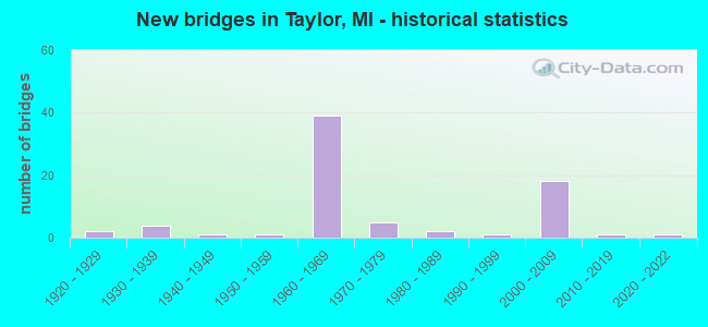
- New bridges - historical statistics
- 21920-1929
- 41930-1939
- 11940-1949
- 11950-1959
- 391960-1969
- 51970-1979
- 21980-1989
- 11990-1999
- 182000-2009
- 12010-2019
- 12020-2022

- Reconstructed bridges - Historical Statistics
- 11950-1959
- 11960-1969
- 21970-1979
- 01980-1989
- 101990-1999
- 42000-2009
- 52010-2019


- Bridge Condition - Deck
- 7.0%Excellent
- 7.0%Very good
- 39.5%Good
- 20.9%Satisfactory
- 14.0%Fair
- 11.6%Poor

- Bridge Condition - Superstructure
- 20.9%Very good
- 32.6%Good
- 23.3%Satisfactory
- 18.6%Fair
- 4.7%Poor

- Bridge Condition - Substructure
- 7.0%Very good
- 53.5%Good
- 20.9%Satisfactory
- 9.3%Fair
- 7.0%Poor
- 2.3%Serious

- Bridge Condition - Channel
- 4.2%Very good
- 37.5%Good
- 33.3%Satisfactory
- 12.5%Fair
- 12.5%Poor

- Bridge Condition - Culverts
- 12.5%Excellent
- 12.5%Very good
- 50.0%Good
- 12.5%Satisfactory
- 12.5%Poor
Find on map >> Show street view
Structure Number: 1112, Location: COLDWATER TWP SEC 19-30 (Lat: 41.927247, Lng: -85.048256), Route carried "on" structure: County highway 2035, Year Built: 1947, Year Reconstructed: 2006, Status: Posted for load, Structure Length: 1.52m (4.99ft), Average Daily Traffic: 1,455 (year 2005), Truck Traffic: 4%, Average Future Daily Traffic: 1,920 (year 2025), Design Load: HS 20, Features Intersected: COLDWATER RIVER, Facility Carried by Structure: GARFIELD ROAD
Minimum Vertical Clearance: 30.48m (100.00ft), Kilometerpoint: 1.972, Lanes on structure: 2, Owner: County Highway Agency, Approaching Roadway Width: 9.1m (29.9ft), Skew: 3 degrees, Material/Design: Steel, Design/Construction: Stringer/Multi-beam, Number Of Spans In Main Unit: 1, Length of Maximum Span: 14.9m (48.9ft), Curb-To-Curb Width: 9.1m (29.9ft), Out-to-Out Width: 9.9m (32.5ft)
Condition: Deck: Fair, Superstructure: Good, Substructure: Good, Channel: Good, Operating Rating: 42.0 metric tons, Method Used To Determine Operating Rating: Load Factor (LF), Inventory Rating: 25.2 metric tons, Method Used To Determine Inventory Rating: Load Factor (LF), Structural Evaluation: Equal to present minimum criteria, Deck Geometry: Somewhat better than minimum adequacy, Waterway Adequacy: Equal to present desirable criteria, Approach Roadway Alignment: Equal to present desirable criteria, Bridge Posting: Required (Relationship of Operating Rating to Maximum Legal Load: 20.0 - 29.9% below), Length Of Structure Improvement: 1.52m (4.99ft), Designated Inspection Frequency: Every 24 months, Inspection Date: August 2020, Bridge Improvement Cost: $45,000, Total Project Cost: $65,000, Deck Structure Type: Concrete Cast-file-Place, Wearing Surface/Protective System: Wearing Surface: Bituminous
Find on map >> Show street view
Structure Number: 1163, Location: GIRARD TWP SEC 19 (Lat: 42.024081, Lng: -85.054892), Route carried "on" structure: County highway , Year Built: 2003, Status: Open, Structure Length: 2.32m (7.61ft), Average Daily Traffic: 75 (year 2003), Truck Traffic: 4%, Average Future Daily Traffic: 125 (year 2023), Design Load: HS 20, Features Intersected: HOG CREEK, Facility Carried by Structure: CADY ROAD
Minimum Vertical Clearance: 30.48m (100.00ft), Kilometerpoint: 1.053, Lanes on structure: 2, Owner: County Highway Agency, Approaching Roadway Width: 7.3m (24.0ft), Skew: 3 degrees, Material/Design: Prestressed concrete, Design/Construction: Box Beam or Girders - Multiple, Number Of Spans In Main Unit: 1, Length of Maximum Span: 21.9m (71.9ft), Curb-To-Curb Width: 9.1m (29.9ft), Out-to-Out Width: 9.5m (31.2ft)
Condition: Deck: Good, Superstructure: Good, Substructure: Good, Channel: Good, Operating Rating: 72.5 metric tons, Method Used To Determine Operating Rating: Load Factor (LF), Inventory Rating: 43.4 metric tons, Method Used To Determine Inventory Rating: Load Factor (LF), Structural Evaluation: Better than present minimum criteria, Deck Geometry: Better than present minimum criteria, Waterway Adequacy: Equal to present desirable criteria, Approach Roadway Alignment: Equal to present desirable criteria, Designated Inspection Frequency: Every 24 months, Inspection Date: October 2020, Deck Structure Type: Concrete Precast Panels, Wearing Surface/Protective System: Wearing Surface: Bituminous, Membrane: Preformed Fabric
Find on map >> Show street view
Structure Number: 1164, Location: GIRARD TWP SEC 17-18 (Lat: 42.036058, Lng: -85.040319), Route carried "on" structure: County highway , Year Built: 1963, Status: Posted for load, Structure Length: 1.48m (4.86ft), Average Daily Traffic: 207 (year 2004), Truck Traffic: 4%, Average Future Daily Traffic: 281 (year 2024), Design Load: HS 20, Features Intersected: HOG CREEK, Facility Carried by Structure: RIVER ROAD
Minimum Vertical Clearance: 30.48m (100.00ft), Kilometerpoint: 10.450, Lanes on structure: 2, Owner: County Highway Agency, Approaching Roadway Width: 9.1m (29.9ft), Material/Design: Wood or Timber, Design/Construction: Slab, Number Of Spans In Main Unit: 2, Length of Maximum Span: 7.2m (23.6ft), Curb or Sidewalk Widths: Left: 0.8m (2.6ft), Right: 0.0m, Curb-To-Curb Width: 7.9m (25.9ft), Out-to-Out Width: 8.3m (27.2ft)
Condition: Deck: Satisfactory, Superstructure: Satisfactory, Substructure: Poor, Channel: Poor, Operating Rating: 32.4 metric tons, Method Used To Determine Operating Rating: Allowable Stress (AS) rating reported by rating factor (RF) method using MS18 loading, Inventory Rating: 22.0 metric tons, Method Used To Determine Inventory Rating: Allowable Stress (AS) rating reported by rating factor (RF) method using MS18 loading, Structural Evaluation: Meets minimum limits, Deck Geometry: Somewhat better than minimum adequacy, Waterway Adequacy: Somewhat better than minimum adequacy, Approach Roadway Alignment: Equal to present desirable criteria, Bridge Posting: Required (Relationship of Operating Rating to Maximum Legal Load: 10.0 - 19.9% below), Length Of Structure Improvement: 1.63m (5.35ft), Designated Inspection Frequency: Every 12 months, Inspection Date: October 2021, Bridge Improvement Cost: $226,000, Roadway Improvement Cost: $25,000, Total Project Cost: $298,000, Deck Structure Type: Wood or Timber, Wearing Surface/Protective System: Wearing Surface: Bituminous
Find on map >> Show street view
Structure Number: 1188, Location: IN VILLAGE OF UNION CITY (Lat: 42.065014, Lng: -85.139128), Route carried "on" structure: City street , Year Built: 1975, Status: Posted for load, Structure Length: 4.05m (13.29ft), Average Daily Traffic: 1,800 (year 1976), Average Future Daily Traffic: 2,700 (year 2010), Design Load: H 20, Features Intersected: ST JOSEPH RIVER, Facility Carried by Structure: PARK STREET
Minimum Vertical Clearance: 30.48m (100.00ft), Kilometerpoint: 0.301, Lanes on structure: 2, Owner: City or Municipal Highway Agency, Approaching Roadway Width: 11.0m (36.1ft), Material/Design: Concrete continuous, Design/Construction: Slab, Number Of Spans In Main Unit: 3, Length of Maximum Span: 16.7m (54.8ft), Curb or Sidewalk Widths: Left: 0.0m, Right: 1.4m (4.6ft), Curb-To-Curb Width: 10.4m (34.1ft), Out-to-Out Width: 12.8m (42.0ft)
Condition: Deck: Fair, Superstructure: Fair, Substructure: Good, Channel: Satisfactory, Operating Rating: 40.5 metric tons, Method Used To Determine Operating Rating: Load Factor (LF) rating reported by rating factor (RF) method using MS18 loading, Inventory Rating: 24.3 metric tons, Method Used To Determine Inventory Rating: Load Factor (LF) rating reported by rating factor (RF) method using MS18 loading, Structural Evaluation: Somewhat better than minimum adequacy, Deck Geometry: Equal to present minimum criteria, Waterway Adequacy: Equal to present desirable criteria, Approach Roadway Alignment: Equal to present desirable criteria, Bridge Posting: Required (Relationship of Operating Rating to Maximum Legal Load: 20.0 - 29.9% below), Length Of Structure Improvement: 6.10m (20.01ft), Designated Inspection Frequency: Every 24 months, Inspection Date: August 2021, Bridge Improvement Cost: $200,000,000, Roadway Improvement Cost: $50,000,000, Total Project Cost: $250,000,000, Deck Structure Type: Concrete Cast-file-Place, Wearing Surface/Protective System: Wearing Surface: Monolithic Concrete
Find on map >> Show street view
Structure Number: 1202, Location: 3.2 MI N OF I-94 (Lat: 42.313297, Lng: -85.181178), Route carried "on" structure: Interstate 194, Year Built: 1966, Status: Open, Structure Length: 6.29m (20.64ft), Average Daily Traffic: 24,600 (year 2013), Truck Traffic: 5%, Average Future Daily Traffic: 28,600 (year 2033), Design Load: HS 20+Mod, Features Intersected: GTW RR
Minimum Vertical Clearance: 30.48m (100.00ft), Kilometerpoint: 6.768, Lanes on structure: 6, Base Highway Network: Yes (Inventory Route: 129, Subroute: 2), Owner: State Highway Agency, Approaching Roadway Width: 28.6m (93.8ft), Skew: 31 degrees, Material/Design: Steel, Design/Construction: Stringer/Multi-beam, Number Of Spans In Main Unit: 3, Length of Maximum Span: 31.2m (102.4ft), Curb-To-Curb Width: 27.6m (90.6ft), Out-to-Out Width: 29.7m (97.4ft)
Condition: Deck: Satisfactory, Superstructure: Fair, Substructure: Satisfactory, Operating Rating: 67.4 metric tons, Method Used To Determine Operating Rating: Load Factor (LF) rating reported by rating factor (RF) method using MS18 loading, Inventory Rating: 40.2 metric tons, Method Used To Determine Inventory Rating: Load Factor (LF) rating reported by rating factor (RF) method using MS18 loading, Structural Evaluation: Somewhat better than minimum adequacy, Deck Geometry: Equal to present minimum criteria, Underclear: Better than present minimum criteria, Approach Roadway Alignment: Equal to present desirable criteria, Designated Inspection Frequency: Every 24 months, Inspection Date: July 2021, Deck Structure Type: Concrete Cast-file-Place, Wearing Surface/Protective System: Wearing Surface: Latex Concrete
Find on map >> Show street view
Structure Number: 1522, Location: 2.3 MI N OF OTSEGO COL (Lat: 45.225892, Lng: -84.592450), Route carried "on" structure: Interstate 75, Year Built: 1962, Status: Open, Structure Length: 1.52m (4.99ft), Average Daily Traffic: 7,777 (year 2018), Truck Traffic: 6%, Average Future Daily Traffic: 8,944 (year 2038), Design Load: HS 20+Mod, Features Intersected: STURGEON RIVER
Minimum Vertical Clearance: 30.48m (100.00ft), Kilometerpoint: 3.689, Lanes on structure: 2, Base Highway Network: Yes (Inventory Route: 55, Subroute: 6), Owner: State Highway Agency, Approaching Roadway Width: 13.4m (44.0ft), Skew: 1 degrees, Material/Design: Steel, Design/Construction: Stringer/Multi-beam, Number Of Spans In Main Unit: 1, Length of Maximum Span: 14.5m (47.6ft), Curb-To-Curb Width: 11.7m (38.4ft), Out-to-Out Width: 13.3m (43.6ft)
Condition: Deck: Satisfactory, Superstructure: Satisfactory, Substructure: Satisfactory, Channel: Good, Operating Rating: 62.5 metric tons, Method Used To Determine Operating Rating: Load Factor (LF) rating reported by rating factor (RF) method using MS18 loading, Inventory Rating: 37.3 metric tons, Method Used To Determine Inventory Rating: Load Factor (LF) rating reported by rating factor (RF) method using MS18 loading, Structural Evaluation: Equal to present minimum criteria, Deck Geometry: Equal to present minimum criteria, Waterway Adequacy: Superior to present desirable criteria, Approach Roadway Alignment: Equal to present minimum criteria, Designated Inspection Frequency: Every 24 months, Inspection Date: June 2021, Deck Structure Type: Concrete Cast-file-Place, Wearing Surface/Protective System: Wearing Surface: Epoxy Overlay
Find on map >> Show street view
Structure Number: 1524, Location: 2.5 MI N OF OTSEGO COL (Lat: 45.229364, Lng: -84.587486), Route carried "on" structure: Interstate 75, Year Built: 1962, Status: Open, Structure Length: 7.68m (25.20ft), Average Daily Traffic: 7,777 (year 2018), Truck Traffic: 6%, Average Future Daily Traffic: 8,944 (year 2038), Design Load: HS 20+Mod, Features Intersected: TROWBRIDGE & D&MRR(ABN)
Minimum Vertical Clearance: 30.48m (100.00ft), Kilometerpoint: 4.238, Lanes on structure: 2, Lanes under structure: 2, Base Highway Network: Yes (Inventory Route: 55, Subroute: 6), Owner: State Highway Agency, Approaching Roadway Width: 13.7m (44.9ft), Skew: 2 degrees, Material/Design: Steel, Design/Construction: Stringer/Multi-beam, Number Of Spans In Main Unit: 4, Length of Maximum Span: 20.7m (67.9ft), Curb-To-Curb Width: 10.2m (33.5ft), Out-to-Out Width: 10.9m (35.8ft)
Condition: Deck: Poor, Superstructure: Good, Substructure: Satisfactory, Operating Rating: 75.5 metric tons, Method Used To Determine Operating Rating: Load Factor (LF) rating reported by rating factor (RF) method using MS18 loading, Inventory Rating: 45.4 metric tons, Method Used To Determine Inventory Rating: Load Factor (LF) rating reported by rating factor (RF) method using MS18 loading, Structural Evaluation: Equal to present minimum criteria, Deck Geometry: Meets minimum limits, Underclear: Somewhat better than minimum adequacy, Approach Roadway Alignment: Equal to present desirable criteria, Designated Inspection Frequency: Every 12 months, Inspection Date: April 2021, Deck Structure Type: Concrete Cast-file-Place, Wearing Surface/Protective System: Wearing Surface: Epoxy Overlay
Find on map >> Show street view
Structure Number: 11117, Location: W LTS OF TAYLOR (Lat: 42.247103, Lng: -83.308278), Route carried "on" structure: Interstate 94, Year Built: 2002, Status: Open, Structure Length: 2.81m (9.22ft), Average Daily Traffic: 74,175 (year 2019), Truck Traffic: 9%, Average Future Daily Traffic: 78,763 (year 2039), Design Load: HS 25 or greater, Features Intersected: INKSTER RD
Minimum Vertical Clearance: 30.48m (100.00ft), Kilometerpoint: 19.905, Lanes on structure: 3, Lanes under structure: 2, Base Highway Network: Yes (Inventory Route: 157, Subroute: 5), Owner: State Highway Agency, Approaching Roadway Width: 18.9m (62.0ft), Skew: 2 degrees, Material/Design: Prestressed concrete, Design/Construction: Box Beam or Girders - Multiple, Number Of Spans In Main Unit: 1, Length of Maximum Span: 26.2m (86.0ft), Curb-To-Curb Width: 19.6m (64.3ft), Out-to-Out Width: 20.6m (67.6ft)
Condition: Deck: Very good, Superstructure: Satisfactory, Substructure: Good, Operating Rating: 97.2 metric tons, Method Used To Determine Operating Rating: Load Factor (LF) rating reported by rating factor (RF) method using MS18 loading, Inventory Rating: 48.0 metric tons, Method Used To Determine Inventory Rating: Load Factor (LF) rating reported by rating factor (RF) method using MS18 loading, Structural Evaluation: Equal to present minimum criteria, Deck Geometry: Superior to present desirable criteria, Underclear: Better than present minimum criteria, Approach Roadway Alignment: Equal to present desirable criteria, Designated Inspection Frequency: Every 24 months, Inspection Date: August 2021, Deck Structure Type: Concrete Cast-file-Place, Wearing Surface/Protective System: Wearing Surface: Epoxy Overlay, Deck Protection: Epoxy Coated Reinforcing
Find on map >> Show street view
Structure Number: 11118, Location: W LTS OF TAYLOR (Lat: 42.249708, Lng: -83.308378), Route carried "on" structure: Interstate 94, Year Built: 2002, Status: Open, Structure Length: 3.82m (12.53ft), Average Daily Traffic: 74,175 (year 2019), Truck Traffic: 9%, Average Future Daily Traffic: 78,763 (year 2039), Design Load: HS 25 or greater, Features Intersected: INKSTER RD
Minimum Vertical Clearance: 30.48m (100.00ft), Kilometerpoint: 20.018, Lanes on structure: 3, Lanes under structure: 2, Base Highway Network: Yes (Inventory Route: 158, Subroute: 2), Owner: State Highway Agency, Approaching Roadway Width: 18.9m (62.0ft), Skew: 4 degrees, Material/Design: Prestressed concrete, Design/Construction: Box Beam or Girders - Multiple, Number Of Spans In Main Unit: 1, Length of Maximum Span: 37.3m (122.4ft), Curb-To-Curb Width: 19.7m (64.6ft), Out-to-Out Width: 20.7m (67.9ft)
Condition: Deck: Very good, Superstructure: Satisfactory, Substructure: Good, Operating Rating: 97.2 metric tons, Method Used To Determine Operating Rating: Load Factor (LF) rating reported by rating factor (RF) method using MS18 loading, Inventory Rating: 75.5 metric tons, Method Used To Determine Inventory Rating: Load Factor (LF) rating reported by rating factor (RF) method using MS18 loading, Structural Evaluation: Equal to present minimum criteria, Deck Geometry: Superior to present desirable criteria, Underclear: Better than present minimum criteria, Approach Roadway Alignment: Equal to present desirable criteria, Designated Inspection Frequency: Every 24 months, Inspection Date: August 2021, Deck Structure Type: Concrete Cast-file-Place, Wearing Surface/Protective System: Wearing Surface: Epoxy Overlay, Deck Protection: Epoxy Coated Reinforcing
Find on map >> Show street view
Structure Number: 11119, Location: IN TAYLOR,OVER ECORSE RD (Lat: 42.254089, Lng: -83.298378), Route carried "on" structure: Interstate 94, Year Built: 1962, Year Reconstructed: 1997, Status: Open, Structure Length: 7.22m (23.69ft), Average Daily Traffic: 74,175 (year 2019), Truck Traffic: 9%, Average Future Daily Traffic: 78,763 (year 2039), Design Load: HS 20, Features Intersected: ECORSE RD
Minimum Vertical Clearance: 30.48m (100.00ft), Kilometerpoint: 21.041, Lanes on structure: 4, Lanes under structure: 5, Base Highway Network: Yes (Inventory Route: 157, Subroute: 5), Owner: State Highway Agency, Approaching Roadway Width: 18.9m (62.0ft), Skew: 4 degrees, Material/Design: Steel, Design/Construction: Stringer/Multi-beam, Number Of Spans In Main Unit: 4, Length of Maximum Span: 19.8m (65.0ft), Curb-To-Curb Width: 17.7m (58.1ft), Out-to-Out Width: 18.7m (61.4ft)
Condition: Deck: Satisfactory, Superstructure: Good, Substructure: Good, Operating Rating: 62.2 metric tons, Method Used To Determine Operating Rating: Load Factor (LF) rating reported by rating factor (RF) method using MS18 loading, Inventory Rating: 37.3 metric tons, Method Used To Determine Inventory Rating: Load Factor (LF) rating reported by rating factor (RF) method using MS18 loading, Structural Evaluation: Better than present minimum criteria, Deck Geometry: Meets minimum limits, Underclear: High priority of corrective action, Approach Roadway Alignment: Equal to present desirable criteria, Designated Inspection Frequency: Every 24 months, Inspection Date: August 2021, Deck Structure Type: Concrete Cast-file-Place, Wearing Surface/Protective System: Wearing Surface: Epoxy Overlay, Deck Protection: Epoxy Coated Reinforcing
Find on map >> Show street view
Structure Number: 1112, Location: IN TAYLOR,OVER ECORSE RD (Lat: 42.253797, Lng: -83.303561), Route carried "on" structure: Interstate 94, Year Built: 1962, Status: Temporarily open, Structure Length: 7.22m (23.69ft), Average Daily Traffic: 74,175 (year 2019), Truck Traffic: 9%, Average Future Daily Traffic: 78,763 (year 2039), Design Load: HS 20, Features Intersected: ECORSE RD
Minimum Vertical Clearance: 30.48m (100.00ft), Kilometerpoint: 20.621, Lanes on structure: 4, Lanes under structure: 5, Base Highway Network: Yes (Inventory Route: 158, Subroute: 2), Owner: State Highway Agency, Approaching Roadway Width: 18.9m (62.0ft), Skew: 4 degrees, Material/Design: Steel, Design/Construction: Stringer/Multi-beam, Number Of Spans In Main Unit: 4, Length of Maximum Span: 19.8m (65.0ft), Curb-To-Curb Width: 17.7m (58.1ft), Out-to-Out Width: 18.7m (61.4ft)
Condition: Deck: Poor, Superstructure: Fair, Substructure: Poor, Operating Rating: 56.1 metric tons, Method Used To Determine Operating Rating: Load Factor (LF) rating reported by rating factor (RF) method using MS18 loading, Inventory Rating: 33.7 metric tons, Method Used To Determine Inventory Rating: Load Factor (LF) rating reported by rating factor (RF) method using MS18 loading, Structural Evaluation: Meets minimum limits, Deck Geometry: Meets minimum limits, Underclear: Equal to present minimum criteria, Approach Roadway Alignment: Equal to present desirable criteria, Designated Inspection Frequency: Every 12 months, Inspection Date: December 2021, Deck Structure Type: Concrete Cast-file-Place, Wearing Surface/Protective System: Wearing Surface: Latex Concrete
Find on map >> Show street view
Structure Number: 11121, Location: IN TAYLOR,OVER BEECH-DALY (Lat: 42.261122, Lng: -83.289397), Route carried "on" structure: Interstate 94, Year Built: 1962, Year Reconstructed: 1977, Status: Open, Structure Length: 4.78m (15.68ft), Average Daily Traffic: 60,077 (year 2007), Truck Traffic: 13%, Average Future Daily Traffic: 65,620 (year 2018), Design Load: HS 20, Features Intersected: BEECH-DALY RD
Minimum Vertical Clearance: 30.48m (100.00ft), Kilometerpoint: 22.121, Lanes on structure: 3, Lanes under structure: 2, Base Highway Network: Yes (Inventory Route: 157, Subroute: 5), Owner: State Highway Agency, Approaching Roadway Width: 15.8m (51.8ft), Skew: 3 degrees, Material/Design: Steel, Design/Construction: Stringer/Multi-beam, Number Of Spans In Main Unit: 3, Length of Maximum Span: 19.2m (63.0ft), Curb-To-Curb Width: 14.3m (46.9ft), Out-to-Out Width: 15.4m (50.5ft)
Condition: Deck: Poor, Superstructure: Satisfactory, Substructure: Serious, Operating Rating: 61.6 metric tons, Method Used To Determine Operating Rating: Load Factor (LF) rating reported by rating factor (RF) method using MS18 loading, Inventory Rating: 36.6 metric tons, Method Used To Determine Inventory Rating: Load Factor (LF) rating reported by rating factor (RF) method using MS18 loading, Structural Evaluation: High priority of corrective action, Deck Geometry: Meets minimum limits, Underclear: Equal to present minimum criteria, Approach Roadway Alignment: Equal to present desirable criteria, Designated Inspection Frequency: Every 12 months, Inspection Date: August 2021, Deck Structure Type: Concrete Cast-file-Place, Wearing Surface/Protective System: Wearing Surface: Latex Concrete
Find on map >> Show street view
Structure Number: 11122, Location: IN TAYLOR,OVER BEECH-DALY (Lat: 42.261639, Lng: -83.289406), Route carried "on" structure: Interstate 94, Year Built: 1962, Year Reconstructed: 1998, Status: Open, Structure Length: 4.72m (15.49ft), Average Daily Traffic: 74,175 (year 2019), Truck Traffic: 9%, Average Future Daily Traffic: 78,763 (year 2039), Design Load: HS 25 or greater, Features Intersected: BEECH-DALY RD
Minimum Vertical Clearance: 30.48m (100.00ft), Kilometerpoint: 22.089, Lanes on structure: 3, Lanes under structure: 2, Base Highway Network: Yes (Inventory Route: 158, Subroute: 2), Owner: State Highway Agency, Approaching Roadway Width: 15.8m (51.8ft), Skew: 3 degrees, Material/Design: Prestressed concrete, Design/Construction: Box Beam or Girders - Single/Spread, Number Of Spans In Main Unit: 3, Length of Maximum Span: 16.5m (54.1ft), Curb-To-Curb Width: 16.8m (55.1ft), Out-to-Out Width: 17.8m (58.4ft)
Condition: Deck: Good, Superstructure: Good, Substructure: Good, Operating Rating: 53.5 metric tons, Method Used To Determine Operating Rating: Load Factor (LF) rating reported by rating factor (RF) method using MS18 loading, Inventory Rating: 25.3 metric tons, Method Used To Determine Inventory Rating: Load Factor (LF) rating reported by rating factor (RF) method using MS18 loading, Structural Evaluation: Equal to present minimum criteria, Deck Geometry: Equal to present minimum criteria, Underclear: Equal to present minimum criteria, Approach Roadway Alignment: Equal to present desirable criteria, Designated Inspection Frequency: Every 24 months, Inspection Date: August 2021, Deck Structure Type: Concrete Cast-file-Place, Wearing Surface/Protective System: Wearing Surface: Epoxy Overlay, Deck Protection: Epoxy Coated Reinforcing
Find on map >> Show street view
Structure Number: 11123, Location: IN TAYLOR,US-24 (Lat: 42.264658, Lng: -83.270253), Route carried "on" structure: Interstate 94, Year Built: 2004, Status: Open, Structure Length: 7.50m (24.61ft), Average Daily Traffic: 81,200 (year 2013), Truck Traffic: 8%, Average Future Daily Traffic: 89,700 (year 2033), Design Load: HS 25 or greater, Features Intersected: US-24 (TELEGRAPH RD)
Minimum Vertical Clearance: 30.48m (100.00ft), Kilometerpoint: 23.758, Lanes on structure: 3, Lanes under structure: 8, Base Highway Network: Yes (Inventory Route: 157, Subroute: 5), Owner: State Highway Agency, Approaching Roadway Width: 21.9m (71.9ft), Skew: 20 degrees, Material/Design: Steel, Design/Construction: Arch - Thru, Number Of Spans In Main Unit: 1, Length of Maximum Span: 73.5m (241.1ft), Curb-To-Curb Width: 22.0m (72.2ft), Out-to-Out Width: 23.0m (75.5ft)
Condition: Deck: Good, Superstructure: Good, Substructure: Good, Operating Rating: 58.0 metric tons, Method Used To Determine Operating Rating: Load Factor (LF) rating reported by rating factor (RF) method using MS18 loading, Inventory Rating: 34.7 metric tons, Method Used To Determine Inventory Rating: Load Factor (LF) rating reported by rating factor (RF) method using MS18 loading, Structural Evaluation: Better than present minimum criteria, Deck Geometry: Superior to present desirable criteria, Underclear: Meets minimum limits, Approach Roadway Alignment: Better than present minimum criteria, Designated Inspection Frequency: Every 24 months, Inspection Date: October 2021, Deck Structure Type: Concrete Cast-file-Place, Wearing Surface/Protective System: Wearing Surface: Epoxy Overlay, Deck Protection: Epoxy Coated Reinforcing
Find on map >> Show street view
Structure Number: 11124, Location: IN TAYLOR,US-24 (Lat: 42.265006, Lng: -83.270239), Route carried "on" structure: Interstate 94, Year Built: 2004, Status: Open, Structure Length: 7.50m (24.61ft), Average Daily Traffic: 81,200 (year 2013), Truck Traffic: 8%, Average Future Daily Traffic: 89,700 (year 2033), Design Load: HS 25 or greater, Features Intersected: US-24(TELEGRAPH RD)
Minimum Vertical Clearance: 30.48m (100.00ft), Kilometerpoint: 23.729, Lanes on structure: 3, Lanes under structure: 8, Base Highway Network: Yes (Inventory Route: 158, Subroute: 2), Owner: State Highway Agency, Approaching Roadway Width: 21.9m (71.9ft), Skew: 20 degrees, Material/Design: Steel, Design/Construction: Arch - Thru, Number Of Spans In Main Unit: 1, Length of Maximum Span: 73.5m (241.1ft), Curb-To-Curb Width: 22.0m (72.2ft), Out-to-Out Width: 23.0m (75.5ft)
Condition: Deck: Good, Superstructure: Good, Substructure: Good, Operating Rating: 58.0 metric tons, Method Used To Determine Operating Rating: Load Factor (LF) rating reported by rating factor (RF) method using MS18 loading, Inventory Rating: 34.7 metric tons, Method Used To Determine Inventory Rating: Load Factor (LF) rating reported by rating factor (RF) method using MS18 loading, Structural Evaluation: Better than present minimum criteria, Deck Geometry: Superior to present desirable criteria, Underclear: Equal to present minimum criteria, Approach Roadway Alignment: Equal to present desirable criteria, Designated Inspection Frequency: Every 24 months, Inspection Date: October 2021, Deck Structure Type: Concrete Cast-file-Place, Wearing Surface/Protective System: Wearing Surface: Epoxy Overlay, Deck Protection: Epoxy Coated Reinforcing
Find on map >> Show street view
Structure Number: 11125, Location: IN TAYLOR OVER MONROE BLV (Lat: 42.265469, Lng: -83.250392), Route carried "on" structure: Interstate 94, Year Built: 2004, Status: Open, Structure Length: 3.81m (12.50ft), Average Daily Traffic: 71,546 (year 2007), Truck Traffic: 10%, Average Future Daily Traffic: 71,250 (year 2018), Design Load: HS 25 or greater, Features Intersected: MONROE BLVD
Minimum Vertical Clearance: 30.48m (100.00ft), Kilometerpoint: 25.411, Lanes on structure: 5, Lanes under structure: 2, Base Highway Network: Yes (Inventory Route: 157, Subroute: 5), Owner: State Highway Agency, Approaching Roadway Width: 25.6m (84.0ft), Material/Design: Prestressed concrete, Design/Construction: Box Beam or Girders - Single/Spread, Number Of Spans In Main Unit: 3, Length of Maximum Span: 23.5m (77.1ft), Curb-To-Curb Width: 25.6m (84.0ft), Out-to-Out Width: 26.7m (87.6ft)
Condition: Deck: Good, Superstructure: Very good, Substructure: Good, Operating Rating: 86.6 metric tons, Method Used To Determine Operating Rating: Load Factor (LF), Inventory Rating: 44.2 metric tons, Method Used To Determine Inventory Rating: Load Factor (LF), Structural Evaluation: Better than present minimum criteria, Deck Geometry: Better than present minimum criteria, Underclear: Equal to present minimum criteria, Approach Roadway Alignment: Equal to present desirable criteria, Designated Inspection Frequency: Every 24 months, Inspection Date: August 2021, Deck Structure Type: Concrete Cast-file-Place, Wearing Surface/Protective System: Wearing Surface: Monolithic Concrete, Deck Protection: Epoxy Coated Reinforcing
Find on map >> Show street view
Structure Number: 11126, Location: IN TAYLOR OVER MONROE BLV (Lat: 42.265917, Lng: -83.250406), Route carried "on" structure: Interstate 94, Year Built: 2004, Status: Open, Structure Length: 3.81m (12.50ft), Average Daily Traffic: 71,546 (year 2007), Truck Traffic: 10%, Average Future Daily Traffic: 71,250 (year 2018), Design Load: HS 25 or greater, Features Intersected: MONROE BLVD
Minimum Vertical Clearance: 30.48m (100.00ft), Kilometerpoint: 25.380, Lanes on structure: 4, Lanes under structure: 2, Base Highway Network: Yes (Inventory Route: 158, Subroute: 2), Owner: State Highway Agency, Approaching Roadway Width: 25.6m (84.0ft), Material/Design: Prestressed concrete, Design/Construction: Box Beam or Girders - Single/Spread, Number Of Spans In Main Unit: 3, Length of Maximum Span: 23.5m (77.1ft), Curb-To-Curb Width: 25.6m (84.0ft), Out-to-Out Width: 27.8m (91.2ft)
Condition: Deck: Good, Superstructure: Good, Substructure: Good, Operating Rating: 84.9 metric tons, Method Used To Determine Operating Rating: Load Factor (LF), Inventory Rating: 42.7 metric tons, Method Used To Determine Inventory Rating: Load Factor (LF), Structural Evaluation: Better than present minimum criteria, Deck Geometry: Superior to present desirable criteria, Underclear: Better than present minimum criteria, Approach Roadway Alignment: Equal to present desirable criteria, Designated Inspection Frequency: Every 24 months, Inspection Date: August 2021, Deck Structure Type: Concrete Cast-file-Place, Wearing Surface/Protective System: Wearing Surface: Monolithic Concrete, Deck Protection: Epoxy Coated Reinforcing
Find on map >> Show street view
Structure Number: 11272, Location: IN TAYLOR (Lat: 42.255514, Lng: -83.269989), Route carried "on" structure: County highway 2057, Year Built: 2004, Status: Open, Structure Length: 4.58m (15.03ft), Average Daily Traffic: 20,000 (year 1978), Truck Traffic: 9%, Average Future Daily Traffic: 41,000 (year 2025), Design Load: HS 25 or greater, Features Intersected: US-24, Facility Carried by Structure: ECORSE RD
Minimum Vertical Clearance: 30.48m (100.00ft), Kilometerpoint: 17.641, Lanes on structure: 4, Lanes under structure: 8, Owner: State Highway Agency, Approaching Roadway Width: 20.7m (67.9ft), Skew: 20 degrees, Material/Design: Prestressed concrete, Design/Construction: Box Beam or Girders - Single/Spread, Number Of Spans In Main Unit: 2, Length of Maximum Span: 22.9m (75.1ft), Curb or Sidewalk Widths: Left: 0.0m, Right: 1.5m (4.9ft), Curb-To-Curb Width: 17.3m (56.8ft), Out-to-Out Width: 24.0m (78.7ft)
Condition: Deck: Good, Superstructure: Very good, Substructure: Good, Operating Rating: 86.5 metric tons, Method Used To Determine Operating Rating: Load Factor (LF) rating reported by rating factor (RF) method using MS18 loading, Inventory Rating: 37.9 metric tons, Method Used To Determine Inventory Rating: Load Factor (LF) rating reported by rating factor (RF) method using MS18 loading, Structural Evaluation: Better than present minimum criteria, Deck Geometry: Somewhat better than minimum adequacy, Underclear: Equal to present minimum criteria, Approach Roadway Alignment: Equal to present desirable criteria, Designated Inspection Frequency: Every 24 months, Inspection Date: August 2020, Deck Structure Type: Concrete Cast-file-Place, Wearing Surface/Protective System: Wearing Surface: Monolithic Concrete, Deck Protection: Epoxy Coated Reinforcing
Find on map >> Show street view
Structure Number: 11276, Location: IN TAYLOR (Lat: 42.185111, Lng: -83.267278), Route carried "on" structure: US 24, Year Built: 1986, Status: Open, Structure Length: 0.85m (2.79ft), Average Daily Traffic: 24,955 (year 2007), Truck Traffic: 2%, Average Future Daily Traffic: 26,093 (year 2018), Design Load: HS 25 or greater, Features Intersected: BLAKLEY DRAIN
Minimum Vertical Clearance: 30.48m (100.00ft), Kilometerpoint: 10.653, Lanes on structure: 4, Base Highway Network: Yes (Inventory Route: 470, Subroute: 38), Owner: State Highway Agency, Approaching Roadway Width: 17.0m (55.8ft), Material/Design: Prestressed concrete, Design/Construction: Stringer/Multi-beam, Number Of Spans In Main Unit: 1, Length of Maximum Span: 8.5m (27.9ft), Curb-To-Curb Width: 24.1m (79.1ft), Out-to-Out Width: 25.2m (82.7ft)
Condition: Deck: Good, Superstructure: Very good, Substructure: Satisfactory, Channel: Satisfactory, Operating Rating: 74.8 metric tons, Method Used To Determine Operating Rating: Load Factor (LF) rating reported by rating factor (RF) method using MS18 loading, Inventory Rating: 44.7 metric tons, Method Used To Determine Inventory Rating: Load Factor (LF) rating reported by rating factor (RF) method using MS18 loading, Structural Evaluation: Equal to present minimum criteria, Deck Geometry: Superior to present desirable criteria, Waterway Adequacy: Equal to present desirable criteria, Approach Roadway Alignment: Equal to present desirable criteria, Designated Inspection Frequency: Every 24 months, Inspection Date: August 2020, Deck Structure Type: Concrete Cast-file-Place, Wearing Surface/Protective System: Wearing Surface: Latex Concrete, Deck Protection: Epoxy Coated Reinforcing
Find on map >> Show street view
Structure Number: 11277, Location: IN TAYLOR (Lat: 42.227358, Lng: -83.268953), Route carried "on" structure: US 24, Year Built: 1986, Year Reconstructed: 2001, Status: Open, Structure Length: 0.85m (2.79ft), Average Daily Traffic: 29,303 (year 2007), Truck Traffic: 4%, Average Future Daily Traffic: 34,838 (year 2018), Design Load: HS 20+Mod, Features Intersected: SEXTON KILFOIL DRAIN
Minimum Vertical Clearance: 30.48m (100.00ft), Kilometerpoint: 15.363, Lanes on structure: 4, Base Highway Network: Yes (Inventory Route: 470, Subroute: 38), Owner: State Highway Agency, Approaching Roadway Width: 18.2m (59.7ft), Material/Design: Prestressed concrete, Design/Construction: Stringer/Multi-beam, Number Of Spans In Main Unit: 1, Length of Maximum Span: 8.5m (27.9ft), Curb or Sidewalk Widths: Left: 0.1m (0.3ft), Right: 1.5m (4.9ft), Curb-To-Curb Width: 15.2m (49.9ft), Out-to-Out Width: 19.6m (64.3ft)
Condition: Deck: Good, Superstructure: Very good, Substructure: Good, Channel: Good, Operating Rating: 59.6 metric tons, Method Used To Determine Operating Rating: Load Factor (LF) rating reported by rating factor (RF) method using MS18 loading, Inventory Rating: 35.6 metric tons, Method Used To Determine Inventory Rating: Load Factor (LF) rating reported by rating factor (RF) method using MS18 loading, Structural Evaluation: Better than present minimum criteria, Deck Geometry: High priority of corrective action, Waterway Adequacy: Equal to present desirable criteria, Approach Roadway Alignment: Equal to present desirable criteria, Designated Inspection Frequency: Every 24 months, Inspection Date: August 2020, Deck Structure Type: Concrete Cast-file-Place, Wearing Surface/Protective System: Wearing Surface: Latex Concrete, Deck Protection: Epoxy Coated Reinforcing
Find on map >> Show street view
Structure Number: 11278, Location: IN TAYLOR (Lat: 42.227414, Lng: -83.269408), Route carried "on" structure: US 24, Year Built: 1964, Year Reconstructed: 2001, Status: Open, Structure Length: 1.06m (3.48ft), Average Daily Traffic: 29,303 (year 2007), Truck Traffic: 4%, Average Future Daily Traffic: 34,838 (year 2018), Design Load: HS 20, Features Intersected: SEXTON KILFOIL DRAIN
Minimum Vertical Clearance: 30.48m (100.00ft), Kilometerpoint: 4.289, Lanes on structure: 3, Base Highway Network: Yes (Inventory Route: 157, Subroute: 6), Owner: State Highway Agency, Approaching Roadway Width: 10.8m (35.4ft), Skew: 3 degrees, Material/Design: Steel, Design/Construction: Stringer/Multi-beam, Number Of Spans In Main Unit: 1, Length of Maximum Span: 10.6m (34.8ft), Curb or Sidewalk Widths: Left: 1.5m (4.9ft), Right: 0.1m (0.3ft), Curb-To-Curb Width: 14.5m (47.6ft), Out-to-Out Width: 16.7m (54.8ft)
Condition: Deck: Satisfactory, Superstructure: Good, Substructure: Satisfactory, Channel: Satisfactory, Operating Rating: 80.7 metric tons, Method Used To Determine Operating Rating: Load Factor (LF) rating reported by rating factor (RF) method using MS18 loading, Inventory Rating: 48.3 metric tons, Method Used To Determine Inventory Rating: Load Factor (LF) rating reported by rating factor (RF) method using MS18 loading, Structural Evaluation: Equal to present minimum criteria, Deck Geometry: Somewhat better than minimum adequacy, Waterway Adequacy: Equal to present desirable criteria, Approach Roadway Alignment: Equal to present desirable criteria, Designated Inspection Frequency: Every 24 months, Inspection Date: August 2020, Deck Structure Type: Concrete Cast-file-Place, Wearing Surface/Protective System: Wearing Surface: Monolithic Concrete, Deck Protection: Epoxy Coated Reinforcing
Find on map >> Show street view
Structure Number: 11281, Location: IN TAYLOR (Lat: 42.198772, Lng: -83.268281), Route carried "on" structure: US 24, Year Built: 1964, Year Reconstructed: 2001, Status: Open, Structure Length: 0.75m (2.46ft), Average Daily Traffic: 22,172 (year 2007), Truck Traffic: 6%, Average Future Daily Traffic: 24,647 (year 2018), Design Load: HS 25 or greater, Features Intersected: FRANK & POET DRAIN
Minimum Vertical Clearance: 30.48m (100.00ft), Kilometerpoint: 1.107, Lanes on structure: 4, Base Highway Network: Yes (Inventory Route: 157, Subroute: 6), Owner: State Highway Agency, Approaching Roadway Width: 14.4m (47.2ft), Material/Design: Prestressed concrete, Design/Construction: Box Beam or Girders - Multiple, Number Of Spans In Main Unit: 1, Length of Maximum Span: 7.5m (24.6ft), Curb or Sidewalk Widths: Left: 3.9m (12.8ft), Right: 0.0m, Curb-To-Curb Width: 15.5m (50.9ft), Out-to-Out Width: 20.1m (65.9ft)
Condition: Deck: Good, Superstructure: Very good, Substructure: Good, Channel: Fair, Operating Rating: 97.2 metric tons, Method Used To Determine Operating Rating: Load Factor (LF) rating reported by rating factor (RF) method using MS18 loading, Inventory Rating: 68.4 metric tons, Method Used To Determine Inventory Rating: Load Factor (LF) rating reported by rating factor (RF) method using MS18 loading, Structural Evaluation: Better than present minimum criteria, Deck Geometry: Meets minimum limits, Waterway Adequacy: Equal to present desirable criteria, Approach Roadway Alignment: Equal to present desirable criteria, Designated Inspection Frequency: Every 24 months, Inspection Date: August 2020, Total Project Cost: $178,000, Deck Structure Type: Concrete Cast-file-Place, Wearing Surface/Protective System: Wearing Surface: Monolithic Concrete, Deck Protection: Epoxy Coated Reinforcing
Find on map >> Show street view
Structure Number: 11284, Location: 4.5 MI N OF FLAT ROCK (Lat: 42.178556, Lng: -83.267042), Route carried "on" structure: US 24, Year Built: 1935, Year Reconstructed: 1983, Status: Open, Structure Length: 5.03m (16.50ft), Average Daily Traffic: 23,232 (year 2007), Truck Traffic: 2%, Average Future Daily Traffic: 23,438 (year 2018), Design Load: H 20, Features Intersected: CONRAIL
Minimum Vertical Clearance: 30.48m (100.00ft), Kilometerpoint: 9.925, Lanes on structure: 4, Base Highway Network: Yes (Inventory Route: 470, Subroute: 38), Owner: State Highway Agency, Approaching Roadway Width: 18.2m (59.7ft), Skew: 4 degrees, Material/Design: Steel, Design/Construction: Stringer/Multi-beam, Number Of Spans In Main Unit: 3, Length of Maximum Span: 17.3m (56.8ft), Curb-To-Curb Width: 17.6m (57.7ft), Out-to-Out Width: 18.8m (61.7ft)
Condition: Deck: Satisfactory, Superstructure: Satisfactory, Substructure: Fair, Operating Rating: 81.3 metric tons, Method Used To Determine Operating Rating: Load Factor (LF) rating reported by rating factor (RF) method using MS18 loading, Inventory Rating: 48.6 metric tons, Method Used To Determine Inventory Rating: Load Factor (LF) rating reported by rating factor (RF) method using MS18 loading, Structural Evaluation: Somewhat better than minimum adequacy, Deck Geometry: Somewhat better than minimum adequacy, Underclear: Meets minimum limits, Approach Roadway Alignment: Better than present minimum criteria, Designated Inspection Frequency: Every 24 months, Other Special Inspection Frequency: Every 12 months, Inspection Date: August 2021, Other Special Inspection Date: August 2021, Deck Structure Type: Concrete Cast-file-Place, Wearing Surface/Protective System: Wearing Surface: Integral Concrete, Deck Protection: Epoxy Coated Reinforcing
Find on map >> Show street view
Structure Number: 11625, Location: 0.2 MI S OF TAYLOR (Lat: 42.182650, Lng: -83.243900), Route carried "on" structure: Interstate 75, Year Built: 1964, Year Reconstructed: 2018, Status: Open, Structure Length: 1.26m (4.13ft), Average Daily Traffic: 46,853 (year 2015), Truck Traffic: 20%, Average Future Daily Traffic: 52,548 (year 2038), Design Load: HS 20+Mod, Features Intersected: BLAKELY DRAIN
Minimum Vertical Clearance: 30.48m (100.00ft), Kilometerpoint: 12.981, Lanes on structure: 4, Base Highway Network: Yes (Inventory Route: 159, Subroute: 6), Owner: State Highway Agency, Approaching Roadway Width: 22.4m (73.5ft), Skew: 3 degrees, Material/Design: Steel, Design/Construction: Stringer/Multi-beam, Number Of Spans In Main Unit: 1, Length of Maximum Span: 11.9m (39.0ft), Curb-To-Curb Width: 23.6m (77.4ft), Out-to-Out Width: 24.6m (80.7ft)
Condition: Deck: Excellent, Superstructure: Very good, Substructure: Satisfactory, Channel: Good, Operating Rating: 97.2 metric tons, Method Used To Determine Operating Rating: Load Factor (LF) rating reported by rating factor (RF) method using MS18 loading, Inventory Rating: 47.3 metric tons, Method Used To Determine Inventory Rating: Load Factor (LF) rating reported by rating factor (RF) method using MS18 loading, Structural Evaluation: Equal to present minimum criteria, Deck Geometry: Superior to present desirable criteria, Waterway Adequacy: Equal to present desirable criteria, Approach Roadway Alignment: Equal to present desirable criteria, Designated Inspection Frequency: Every 24 months, Inspection Date: September 2020, Deck Structure Type: Concrete Cast-file-Place, Wearing Surface/Protective System: Wearing Surface: Monolithic Concrete, Deck Protection: Epoxy Coated Reinforcing
Find on map >> Show street view
Structure Number: 11626, Location: 0.2 MI S OF TAYLOR (Lat: 42.182361, Lng: -83.243217), Route carried "on" structure: Interstate 75, Year Built: 1964, Year Reconstructed: 2019, Status: Open, Structure Length: 1.22m (4.00ft), Average Daily Traffic: 46,853 (year 2015), Truck Traffic: 20%, Average Future Daily Traffic: 52,548 (year 2038), Design Load: HS 20+Mod, Features Intersected: BLAKELY DRAIN
Minimum Vertical Clearance: 30.48m (100.00ft), Kilometerpoint: 12.977, Lanes on structure: 3, Base Highway Network: Yes (Inventory Route: 159, Subroute: 10), Owner: State Highway Agency, Approaching Roadway Width: 18.3m (60.0ft), Skew: 3 degrees, Material/Design: Steel, Design/Construction: Stringer/Multi-beam, Number Of Spans In Main Unit: 1, Length of Maximum Span: 11.4m (37.4ft), Curb-To-Curb Width: 18.3m (60.0ft), Out-to-Out Width: 19.3m (63.3ft)
Condition: Deck: Very good, Superstructure: Very good, Substructure: Very good, Channel: Good, Operating Rating: 80.0 metric tons, Method Used To Determine Operating Rating: Load Factor (LF) rating reported by rating factor (RF) method using MS18 loading, Inventory Rating: 48.0 metric tons, Method Used To Determine Inventory Rating: Load Factor (LF) rating reported by rating factor (RF) method using MS18 loading, Structural Evaluation: Equal to present desirable criteria, Deck Geometry: Better than present minimum criteria, Waterway Adequacy: Equal to present desirable criteria, Approach Roadway Alignment: Equal to present desirable criteria, Designated Inspection Frequency: Every 24 months, Inspection Date: July 2021, Deck Structure Type: Concrete Cast-file-Place, Wearing Surface/Protective System: Wearing Surface: Monolithic Concrete, Deck Protection: Epoxy Coated Reinforcing
Find on map >> Show street view
Structure Number: 11629, Location: IN TAYLOR (Lat: 42.195714, Lng: -83.239708), Route carried "on" structure: Ramp Interstate 75, Year Built: 1966, Status: Open, Structure Length: 0.76m (2.49ft), Average Daily Traffic: 40,584 (year 2005), Truck Traffic: 16%, Average Future Daily Traffic: 43,839 (year 2025), Design Load: HS 20, Features Intersected: FRANK & POET DRAIN
Minimum Vertical Clearance: 30.48m (100.00ft), Kilometerpoint: 0.246, Lanes on structure: 1, Owner: State Highway Agency, Approaching Roadway Width: 16.5m (54.1ft), Skew: 2 degrees, Material/Design: Concrete, Design/Construction: Culvert, Number Of Spans In Main Unit: 2, Length of Maximum Span: 3.9m (12.8ft), Curb-To-Curb Width: 16.5m (54.1ft), Out-to-Out Width: 21.4m (70.2ft)
Condition: Channel: Fair, Culverts: Good, Operating Rating: 36.6 metric tons, Method Used To Determine Operating Rating: Load Factor (LF) rating reported by rating factor (RF) method using MS18 loading, Inventory Rating: 22.0 metric tons, Method Used To Determine Inventory Rating: Load Factor (LF) rating reported by rating factor (RF) method using MS18 loading, Structural Evaluation: Somewhat better than minimum adequacy, Deck Geometry: Superior to present desirable criteria, Waterway Adequacy: Equal to present desirable criteria, Approach Roadway Alignment: Equal to present desirable criteria, Designated Inspection Frequency: Every 24 months, Inspection Date: July 2020, Deck Structure Type: Concrete Cast-file-Place, Wearing Surface/Protective System: Wearing Surface: Monolithic Concrete
Find on map >> Show street view
Structure Number: 1163, Location: IN TAYLOR (Lat: 42.195828, Lng: -83.240278), Route carried "on" structure: Interstate 75, Year Built: 1966, Status: Open, Structure Length: 0.76m (2.49ft), Average Daily Traffic: 83,412 (year 2007), Truck Traffic: 19%, Average Future Daily Traffic: 74,095 (year 2018), Design Load: HS 20, Features Intersected: FRANK & POET DRAIN
Minimum Vertical Clearance: 30.48m (100.00ft), Kilometerpoint: 14.502, Lanes on structure: 7, Base Highway Network: Yes (Inventory Route: 159, Subroute: 10), Owner: State Highway Agency, Approaching Roadway Width: 16.5m (54.1ft), Material/Design: Concrete, Design/Construction: Culvert, Number Of Spans In Main Unit: 2, Length of Maximum Span: 3.9m (12.8ft), Curb-To-Curb Width: 16.5m (54.1ft), Out-to-Out Width: 42.0m (137.8ft)
Condition: Channel: Satisfactory, Culverts: Satisfactory, Operating Rating: 32.7 metric tons, Method Used To Determine Operating Rating: Load Factor (LF) rating reported by rating factor (RF) method using MS18 loading, Inventory Rating: 19.4 metric tons, Method Used To Determine Inventory Rating: Load Factor (LF) rating reported by rating factor (RF) method using MS18 loading, Structural Evaluation: Meets minimum limits, Deck Geometry: High priority of replacement, Waterway Adequacy: Equal to present desirable criteria, Approach Roadway Alignment: Equal to present desirable criteria, Designated Inspection Frequency: Every 24 months, Inspection Date: July 2020, Deck Structure Type: Concrete Cast-file-Place, Wearing Surface/Protective System: Wearing Surface: Monolithic Concrete
Find on map >> Show street view
Structure Number: 11635, Location: S OF EUREKA (Lat: 42.197278, Lng: -83.235083), Route carried "on" structure: Ramp City street , Year Built: 1965, Status: Open, Structure Length: 1.06m (3.48ft), Average Daily Traffic: 1,750 (year 2006), Truck Traffic: 3%, Average Future Daily Traffic: 2,013 (year 2026), Design Load: HS 20, Features Intersected: FRANK & POET DRAIN, Facility Carried by Structure: HURON STREET
Minimum Vertical Clearance: 30.48m (100.00ft), Kilometerpoint: 0.269, Lanes on structure: 2, Owner: City or Municipal Highway Agency, Approaching Roadway Width: 11.0m (36.1ft), Material/Design: Steel, Design/Construction: Culvert, Number Of Spans In Main Unit: 2, Length of Maximum Span: 5.4m (17.7ft)
Condition: Channel: Satisfactory, Culverts: Good, Operating Rating: 79.7 metric tons, Method Used To Determine Operating Rating: Load Factor (LF) rating reported by rating factor (RF) method using MS18 loading, Inventory Rating: 78.7 metric tons, Method Used To Determine Inventory Rating: Load Factor (LF) rating reported by rating factor (RF) method using MS18 loading, Structural Evaluation: Better than present minimum criteria, Waterway Adequacy: Equal to present desirable criteria, Approach Roadway Alignment: Equal to present desirable criteria, Length Of Structure Improvement: 7.93m (26.02ft), Designated Inspection Frequency: Every 24 months, Inspection Date: December 2020, Bridge Improvement Cost: $224,000, Roadway Improvement Cost: $22,000, Total Project Cost: $263,000
Find on map >> Show street view
Structure Number: 1164, Location: IN TAYLOR (Lat: 42.203750, Lng: -83.233644), Route carried "on" structure: Interstate 75, Year Built: 1965, Year Reconstructed: 2006, Status: Open, Structure Length: 6.50m (21.33ft), Average Daily Traffic: 46,853 (year 2015), Truck Traffic: 20%, Average Future Daily Traffic: 52,548 (year 2038), Design Load: HS 20+Mod, Features Intersected: GTW RR
Minimum Vertical Clearance: 30.48m (100.00ft), Kilometerpoint: 15.552, Lanes on structure: 3, Base Highway Network: Yes (Inventory Route: 159, Subroute: 10), Owner: State Highway Agency, Approaching Roadway Width: 16.4m (53.8ft), Skew: 4 degrees, Material/Design: Steel, Design/Construction: Stringer/Multi-beam, Number Of Spans In Main Unit: 3, Length of Maximum Span: 23.1m (75.8ft), Curb-To-Curb Width: 15.7m (51.5ft), Out-to-Out Width: 16.6m (54.5ft)
Condition: Deck: Fair, Superstructure: Satisfactory, Substructure: Good, Operating Rating: 61.2 metric tons, Method Used To Determine Operating Rating: Load Factor (LF) rating reported by rating factor (RF) method using MS18 loading, Inventory Rating: 36.6 metric tons, Method Used To Determine Inventory Rating: Load Factor (LF) rating reported by rating factor (RF) method using MS18 loading, Structural Evaluation: Equal to present minimum criteria, Deck Geometry: Somewhat better than minimum adequacy, Approach Roadway Alignment: Equal to present desirable criteria, Designated Inspection Frequency: Every 24 months, Inspection Date: July 2021, Deck Structure Type: Concrete Cast-file-Place, Wearing Surface/Protective System: Wearing Surface: Epoxy Overlay, Deck Protection: Epoxy Coated Reinforcing
Find on map >> Show street view
Structure Number: 11641, Location: IN TAYLOR (Lat: 42.204100, Lng: -83.233661), Route carried "on" structure: Interstate 75, Year Built: 1965, Year Reconstructed: 2006, Status: Open, Structure Length: 6.50m (21.33ft), Average Daily Traffic: 46,853 (year 2015), Truck Traffic: 20%, Average Future Daily Traffic: 52,548 (year 2038), Design Load: HS 20+Mod, Features Intersected: GTW RR
Minimum Vertical Clearance: 30.48m (100.00ft), Kilometerpoint: 15.589, Lanes on structure: 3, Base Highway Network: Yes (Inventory Route: 159, Subroute: 6), Owner: State Highway Agency, Approaching Roadway Width: 16.4m (53.8ft), Skew: 4 degrees, Material/Design: Steel, Design/Construction: Stringer/Multi-beam, Number Of Spans In Main Unit: 3, Length of Maximum Span: 23.1m (75.8ft), Curb-To-Curb Width: 15.7m (51.5ft), Out-to-Out Width: 16.6m (54.5ft)
Condition: Deck: Satisfactory, Superstructure: Good, Substructure: Good, Operating Rating: 61.2 metric tons, Method Used To Determine Operating Rating: Load Factor (LF) rating reported by rating factor (RF) method using MS18 loading, Inventory Rating: 36.6 metric tons, Method Used To Determine Inventory Rating: Load Factor (LF) rating reported by rating factor (RF) method using MS18 loading, Structural Evaluation: Better than present minimum criteria, Deck Geometry: Somewhat better than minimum adequacy, Approach Roadway Alignment: Equal to present desirable criteria, Designated Inspection Frequency: Every 24 months, Inspection Date: September 2020, Deck Structure Type: Concrete Cast-file-Place, Wearing Surface/Protective System: Wearing Surface: Epoxy Overlay, Deck Protection: Epoxy Coated Reinforcing
Find on map >> Show street view
Structure Number: 11653, Location: 0.8 MI S OF TAYLOR (Lat: 42.170556, Lng: -83.243092), Route carried "on" structure: County highway 2057, Year Built: 2006, Status: Open, Structure Length: 6.10m (20.01ft), Average Daily Traffic: 21,800 (year 2005), Truck Traffic: 4%, Average Future Daily Traffic: 51,600 (year 2026), Design Load: HS 25 or greater, Features Intersected: I-75, Facility Carried by Structure: SIBLEY RD
Minimum Vertical Clearance: 30.48m (100.00ft), Kilometerpoint: 13.266, Lanes on structure: 5, Lanes under structure: 6, Owner: State Highway Agency, Approaching Roadway Width: 23.2m (76.1ft), Material/Design: Steel, Design/Construction: Stringer/Multi-beam, Number Of Spans In Main Unit: 2, Length of Maximum Span: 30.0m (98.4ft), Curb-To-Curb Width: 24.4m (80.1ft), Out-to-Out Width: 25.4m (83.3ft)
Condition: Deck: Good, Superstructure: Very good, Substructure: Very good, Operating Rating: 76.5 metric tons, Method Used To Determine Operating Rating: Load Factor (LF) rating reported by rating factor (RF) method using MS18 loading, Inventory Rating: 45.7 metric tons, Method Used To Determine Inventory Rating: Load Factor (LF) rating reported by rating factor (RF) method using MS18 loading, Structural Evaluation: Equal to present desirable criteria, Deck Geometry: Superior to present desirable criteria, Underclear: Meets minimum limits, Approach Roadway Alignment: Equal to present desirable criteria, Designated Inspection Frequency: Every 24 months, Inspection Date: July 2020, Deck Structure Type: Concrete Cast-file-Place, Wearing Surface/Protective System: Wearing Surface: Monolithic Concrete, Deck Protection: Epoxy Coated Reinforcing
Find on map >> Show street view
Structure Number: 11654, Location: S LTS OF TAYLOR (Lat: 42.183978, Lng: -83.243261), Route carried "on" structure: County highway 2057, Year Built: 1964, Status: Open, Structure Length: 10.69m (35.07ft), Average Daily Traffic: 40,584 (year 2005), Truck Traffic: 5%, Average Future Daily Traffic: 43,839 (year 2025), Design Load: H 20, Features Intersected: I-75, Facility Carried by Structure: PENNSYLVANIA RD
Minimum Vertical Clearance: 30.48m (100.00ft), Kilometerpoint: 14.309, Lanes on structure: 2, Lanes under structure: 8, Owner: State Highway Agency, Approaching Roadway Width: 12.2m (40.0ft), Material/Design: Steel, Design/Construction: Stringer/Multi-beam, Number Of Spans In Main Unit: 6, Length of Maximum Span: 25.1m (82.3ft), Curb-To-Curb Width: 9.8m (32.2ft), Out-to-Out Width: 10.7m (35.1ft)
Condition: Deck: Fair, Superstructure: Fair, Substructure: Good, Operating Rating: 69.0 metric tons, Method Used To Determine Operating Rating: Load Factor (LF) rating reported by rating factor (RF) method using MS18 loading, Inventory Rating: 41.5 metric tons, Method Used To Determine Inventory Rating: Load Factor (LF) rating reported by rating factor (RF) method using MS18 loading, Structural Evaluation: Somewhat better than minimum adequacy, Deck Geometry: Meets minimum limits, Underclear: High priority of corrective action, Approach Roadway Alignment: Equal to present minimum criteria, Designated Inspection Frequency: Every 24 months, Inspection Date: July 2020, Deck Structure Type: Concrete Cast-file-Place, Wearing Surface/Protective System: Wearing Surface: Epoxy Overlay, Deck Protection: Epoxy Coated Reinforcing
Find on map >> Show street view
Structure Number: 11655, Location: IN TAYLOR OVER US-24 CONN (Lat: 42.187711, Lng: -83.244086), Route carried "on" structure: Interstate 75, Year Built: 1964, Year Reconstructed: 2018, Status: Open, Structure Length: 5.81m (19.06ft), Average Daily Traffic: 46,853 (year 2015), Truck Traffic: 20%, Average Future Daily Traffic: 52,548 (year 2038), Design Load: HS 20+Mod, Features Intersected: US-24 CONN
Minimum Vertical Clearance: 30.48m (100.00ft), Kilometerpoint: 13.545, Lanes on structure: 3, Lanes under structure: 2, Base Highway Network: Yes (Inventory Route: 159, Subroute: 6), Owner: State Highway Agency, Approaching Roadway Width: 18.3m (60.0ft), Skew: 5 degrees, Material/Design: Steel, Design/Construction: Stringer/Multi-beam, Number Of Spans In Main Unit: 3, Length of Maximum Span: 24.2m (79.4ft), Curb-To-Curb Width: 18.3m (60.0ft), Out-to-Out Width: 19.3m (63.3ft)
Condition: Deck: Excellent, Superstructure: Good, Substructure: Good, Operating Rating: 69.0 metric tons, Method Used To Determine Operating Rating: Load Factor (LF) rating reported by rating factor (RF) method using MS18 loading, Inventory Rating: 41.5 metric tons, Method Used To Determine Inventory Rating: Load Factor (LF) rating reported by rating factor (RF) method using MS18 loading, Structural Evaluation: Better than present minimum criteria, Deck Geometry: Better than present minimum criteria, Underclear: High priority of corrective action, Approach Roadway Alignment: Equal to present desirable criteria, Designated Inspection Frequency: Every 24 months, Inspection Date: September 2020, Deck Structure Type: Concrete Cast-file-Place, Wearing Surface/Protective System: Wearing Surface: Monolithic Concrete, Deck Protection: Epoxy Coated Reinforcing
Find on map >> Show street view
Structure Number: 11656, Location: IN TAYLOR OVER EUREKA RD (Lat: 42.198314, Lng: -83.239156), Route carried "on" structure: Interstate 75, Year Built: 1966, Year Reconstructed: 2019, Status: Open, Structure Length: 7.00m (22.97ft), Average Daily Traffic: 46,853 (year 2015), Truck Traffic: 20%, Average Future Daily Traffic: 52,548 (year 2038), Design Load: HS 20+Mod, Features Intersected: EUREKA RD
Minimum Vertical Clearance: 30.48m (100.00ft), Kilometerpoint: 14.794, Lanes on structure: 4, Lanes under structure: 8, Base Highway Network: Yes (Inventory Route: 159, Subroute: 10), Owner: State Highway Agency, Approaching Roadway Width: 23.5m (77.1ft), Skew: 2 degrees, Material/Design: Steel, Design/Construction: Stringer/Multi-beam, Number Of Spans In Main Unit: 4, Length of Maximum Span: 24.7m (81.0ft), Curb-To-Curb Width: 23.8m (78.1ft), Out-to-Out Width: 24.8m (81.4ft)
Condition: Deck: Good, Superstructure: Good, Substructure: Good, Operating Rating: 59.6 metric tons, Method Used To Determine Operating Rating: Load Factor (LF) rating reported by rating factor (RF) method using MS18 loading, Inventory Rating: 35.6 metric tons, Method Used To Determine Inventory Rating: Load Factor (LF) rating reported by rating factor (RF) method using MS18 loading, Structural Evaluation: Better than present minimum criteria, Deck Geometry: Superior to present desirable criteria, Underclear: Somewhat better than minimum adequacy, Approach Roadway Alignment: Equal to present desirable criteria, Designated Inspection Frequency: Every 24 months, Inspection Date: July 2021, Deck Structure Type: Concrete Cast-file-Place, Wearing Surface/Protective System: Wearing Surface: Monolithic Concrete, Deck Protection: Epoxy Coated Reinforcing
Find on map >> Show street view
Structure Number: 11657, Location: IN TAYLOR OVER EUREKA RD (Lat: 42.198303, Lng: -83.239528), Route carried "on" structure: Interstate 75, Year Built: 1966, Year Reconstructed: 2018, Status: Open, Structure Length: 6.96m (22.83ft), Average Daily Traffic: 46,853 (year 2015), Truck Traffic: 20%, Average Future Daily Traffic: 52,548 (year 2038), Design Load: HS 20+Mod, Features Intersected: EUREKA RD
Minimum Vertical Clearance: 30.48m (100.00ft), Kilometerpoint: 14.781, Lanes on structure: 3, Lanes under structure: 8, Base Highway Network: Yes (Inventory Route: 159, Subroute: 6), Owner: State Highway Agency, Approaching Roadway Width: 18.9m (62.0ft), Skew: 2 degrees, Material/Design: Steel, Design/Construction: Stringer/Multi-beam, Number Of Spans In Main Unit: 4, Length of Maximum Span: 24.6m (80.7ft), Curb-To-Curb Width: 18.3m (60.0ft), Out-to-Out Width: 19.3m (63.3ft)
Condition: Deck: Excellent, Superstructure: Good, Substructure: Very good, Operating Rating: 85.5 metric tons, Method Used To Determine Operating Rating: Load Factor (LF) rating reported by rating factor (RF) method using MS18 loading, Inventory Rating: 51.2 metric tons, Method Used To Determine Inventory Rating: Load Factor (LF) rating reported by rating factor (RF) method using MS18 loading, Structural Evaluation: Better than present minimum criteria, Deck Geometry: Better than present minimum criteria, Underclear: High priority of corrective action, Approach Roadway Alignment: Equal to present desirable criteria, Designated Inspection Frequency: Every 24 months, Inspection Date: September 2020, Deck Structure Type: Concrete Cast-file-Place, Wearing Surface/Protective System: Wearing Surface: Monolithic Concrete, Deck Protection: Epoxy Coated Reinforcing
Find on map >> Show street view
Structure Number: 11879, Location: IN TAYLOR (Lat: 42.190494, Lng: -83.253761), Route carried "on" structure: Alternate US 24, Year Built: 1963, Year Reconstructed: 2001, Status: Open, Structure Length: 5.54m (18.18ft), Average Daily Traffic: 9,440 (year 2007), Truck Traffic: 11%, Average Future Daily Traffic: 9,227 (year 2018), Design Load: HS 20+Mod, Features Intersected: CONRAIL
Minimum Vertical Clearance: 30.48m (100.00ft), Kilometerpoint: 1.144, Lanes on structure: 2, Base Highway Network: Yes (Inventory Route: 157, Subroute: 5), Owner: State Highway Agency, Approaching Roadway Width: 12.5m (41.0ft), Skew: 4 degrees, Material/Design: Steel, Design/Construction: Stringer/Multi-beam, Number Of Spans In Main Unit: 3, Length of Maximum Span: 18.4m (60.4ft), Curb-To-Curb Width: 12.2m (40.0ft), Out-to-Out Width: 13.2m (43.3ft)
Condition: Deck: Good, Superstructure: Satisfactory, Substructure: Good, Operating Rating: 81.2 metric tons, Method Used To Determine Operating Rating: Load Factor (LF), Inventory Rating: 48.6 metric tons, Method Used To Determine Inventory Rating: Load Factor (LF), Structural Evaluation: Equal to present minimum criteria, Deck Geometry: Better than present minimum criteria, Underclear: Better than present minimum criteria, Approach Roadway Alignment: Equal to present desirable criteria, Designated Inspection Frequency: Every 24 months, Other Special Inspection Frequency: Every 11 months, Inspection Date: November 2021, Other Special Inspection Date: December 2021, Deck Structure Type: Concrete Cast-file-Place, Wearing Surface/Protective System: Wearing Surface: Monolithic Concrete, Deck Protection: Epoxy Coated Reinforcing
Find on map >> Show street view
Structure Number: 1188, Location: IN TAYLOR (Lat: 42.190211, Lng: -83.254103), Route carried "on" structure: Alternate US 24, Year Built: 1963, Year Reconstructed: 2001, Status: Open, Structure Length: 5.54m (18.18ft), Average Daily Traffic: 9,440 (year 2007), Truck Traffic: 11%, Average Future Daily Traffic: 9,227 (year 2018), Design Load: HS 20+Mod, Features Intersected: CONRAIL
Minimum Vertical Clearance: 30.48m (100.00ft), Kilometerpoint: 1.139, Lanes on structure: 2, Base Highway Network: Yes (Inventory Route: 157, Subroute: 9), Owner: State Highway Agency, Approaching Roadway Width: 12.5m (41.0ft), Skew: 4 degrees, Material/Design: Steel, Design/Construction: Stringer/Multi-beam, Number Of Spans In Main Unit: 3, Length of Maximum Span: 18.4m (60.4ft), Curb-To-Curb Width: 12.2m (40.0ft), Out-to-Out Width: 13.2m (43.3ft)
Condition: Deck: Good, Superstructure: Fair, Substructure: Satisfactory, Operating Rating: 81.2 metric tons, Method Used To Determine Operating Rating: Load Factor (LF), Inventory Rating: 48.6 metric tons, Method Used To Determine Inventory Rating: Load Factor (LF), Structural Evaluation: Somewhat better than minimum adequacy, Deck Geometry: Better than present minimum criteria, Underclear: Better than present minimum criteria, Approach Roadway Alignment: Equal to present desirable criteria, Designated Inspection Frequency: Every 24 months, Other Special Inspection Frequency: Every 6 months, Inspection Date: November 2021, Other Special Inspection Date: November 2021, Deck Structure Type: Concrete Cast-file-Place, Wearing Surface/Protective System: Wearing Surface: Monolithic Concrete, Deck Protection: Epoxy Coated Reinforcing
Find on map >> Show street view
Structure Number: 11881, Location: IN TAYLOR OVER RACHO RD (Lat: 42.189158, Lng: -83.247819), Route carried "on" structure: Alternate US 24, Year Built: 1964, Year Reconstructed: 2001, Status: Open, Structure Length: 4.36m (14.30ft), Average Daily Traffic: 9,440 (year 2007), Truck Traffic: 11%, Average Future Daily Traffic: 9,227 (year 2018), Design Load: HS 20+Mod, Features Intersected: RACHO RD
Minimum Vertical Clearance: 30.48m (100.00ft), Kilometerpoint: 0.595, Lanes on structure: 2, Lanes under structure: 2, Base Highway Network: Yes (Inventory Route: 157, Subroute: 9), Owner: State Highway Agency, Approaching Roadway Width: 12.5m (41.0ft), Skew: 3 degrees, Material/Design: Steel, Design/Construction: Stringer/Multi-beam, Number Of Spans In Main Unit: 3, Length of Maximum Span: 15.2m (49.9ft), Curb-To-Curb Width: 12.2m (40.0ft), Out-to-Out Width: 13.2m (43.3ft)
Condition: Deck: Satisfactory, Superstructure: Poor, Substructure: Good, Operating Rating: 60.3 metric tons, Method Used To Determine Operating Rating: Load Factor (LF) rating reported by rating factor (RF) method using MS18 loading, Inventory Rating: 36.0 metric tons, Method Used To Determine Inventory Rating: Load Factor (LF) rating reported by rating factor (RF) method using MS18 loading, Structural Evaluation: Meets minimum limits, Deck Geometry: Better than present minimum criteria, Underclear: Meets minimum limits, Approach Roadway Alignment: Equal to present desirable criteria, Designated Inspection Frequency: Every 12 months, Inspection Date: November 2021, Deck Structure Type: Concrete Cast-file-Place, Wearing Surface/Protective System: Wearing Surface: Monolithic Concrete, Deck Protection: Epoxy Coated Reinforcing