Bridge Statistics for Tampa, Florida (FL)
Condition, Traffic, Stress, Structural Evaluation, Project Costs
- National Bridge Inventory (NBI) Statistics
- 762Number of bridges
- 24,088ft / 7,342mTotal length
- $26,718,000Total costs
- 21,156,929Total average daily traffic
- 1,639,142Total average daily truck traffic
- National Bridge Inventory (NBI) Registered Bridges for Tampa
- No street view available for this location
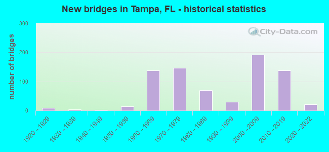
- New bridges - historical statistics
- 11910-1919
- 81920-1929
- 31930-1939
- 11940-1949
- 141950-1959
- 1381960-1969
- 1471970-1979
- 701980-1989
- 301990-1999
- 1922000-2009
- 1372010-2019
- 212020-2022

- Reconstructed bridges - Historical Statistics
- 11940-1949
- 01950-1959
- 41960-1969
- 61970-1979
- 41980-1989
- 211990-1999
- 562000-2009
- 72010-2019
- 32020-2022


- Bridge Condition - Deck
- 30.5%Excellent
- 53.3%Very good
- 15.0%Good
- 1.2%Satisfactory
- 0.6%Fair
- 0.3%Poor

- Bridge Condition - Superstructure
- 28.7%Excellent
- 64.5%Very good
- 3.1%Good
- 2.8%Satisfactory
- 0.9%Fair
- 0.3%Poor

- Bridge Condition - Substructure
- 0.6%Excellent
- 38.0%Very good
- 54.5%Good
- 5.0%Satisfactory
- 1.9%Fair

- Bridge Condition - Channel
- 8.9%Excellent
- 15.6%Very good
- 60.7%Good
- 13.3%Satisfactory
- 1.5%Fair

- Bridge Condition - Culverts
- 4.7%Very good
- 62.8%Good
- 27.9%Satisfactory
- 4.7%Fair
Find on map >> Show street view
Structure Number: 10014, Location: 1.6 MI E OF SR S-765A (Lat: 26.884639, Lng: -81.978611), Route carried "on" structure: County highway 768, Year Built: 1967, Status: Open, Structure Length: 1.65m (5.41ft), Average Daily Traffic: 2,400 (year 2020), Truck Traffic: 10%, Average Future Daily Traffic: 4,164 (year 2042), Features Intersected: ALLIGATOR CREEK
Minimum Vertical Clearance: 30+ m (98+ ft), Kilometerpoint: 2.718, Lanes on structure: 2, Owner: County Highway Agency, Approaching Roadway Width: 6.2m (20.3ft), Skew: 4 degrees, Material/Design: Concrete, Design/Construction: Culvert, Number Of Spans In Main Unit: 3, Length of Maximum Span: 5.1m (16.7ft)
Condition: Channel: Satisfactory, Culverts: Fair, Operating Rating: 74.5 metric tons, Method Used To Determine Operating Rating: Load Factor (LF), Inventory Rating: 44.5 metric tons, Method Used To Determine Inventory Rating: Load Factor (LF), Structural Evaluation: Somewhat better than minimum adequacy, Waterway Adequacy: Equal to present desirable criteria, Approach Roadway Alignment: Equal to present desirable criteria, Designated Inspection Frequency: Every 24 months, Inspection Date: May 2021
Find on map >> Show street view
Structure Number: 1002, Location: 4.2 MI EAST OF US-17 (Lat: 26.946806, Lng: -81.933944), Route carried "on" structure: County highway 74, Year Built: 1950, Year Reconstructed: 1973, Status: Open, Structure Length: 1.13m (3.71ft), Average Daily Traffic: 5,300 (year 2020), Truck Traffic: 31%, Average Future Daily Traffic: 9,196 (year 2042), Design Load: H 15, Features Intersected: MYRTLE SLOUGH
Minimum Vertical Clearance: 30+ m (98+ ft), Kilometerpoint: 6.698, Lanes on structure: 2, Owner: County Highway Agency, Approaching Roadway Width: 9.4m (30.8ft), Skew: 2 degrees, Material/Design: Concrete, Design/Construction: Culvert, Number Of Spans In Main Unit: 3, Length of Maximum Span: 3.7m (12.1ft)
Condition: Channel: Good, Culverts: Satisfactory, Operating Rating: 37.5 metric tons, Method Used To Determine Operating Rating: Load Factor (LF), Inventory Rating: 22.5 metric tons, Method Used To Determine Inventory Rating: Load Factor (LF), Structural Evaluation: Somewhat better than minimum adequacy, Waterway Adequacy: Better than present minimum criteria, Approach Roadway Alignment: Equal to present desirable criteria, Designated Inspection Frequency: Every 24 months, Inspection Date: May 2021
Find on map >> Show street view
Structure Number: 10029, Location: 0.8 MILE SW OF CR-776 (Lat: 26.934369, Lng: -82.353047), Route carried "on" structure: County highway 776, Year Built: 1965, Year Reconstructed: 2018, Status: Posted for load, Structure Length: 30.65m (100.56ft), Average Daily Traffic: 11,300 (year 2022), Truck Traffic: 5%, Average Future Daily Traffic: 14,125 (year 2042), Features Intersected: LEMON BAY ICWW, Facility Carried by Structure: BEACH ROAD
Minimum Vertical Clearance: 5.39m (17.68ft), Kilometerpoint: 1.302, Lanes on structure: 2, Owner: County Highway Agency, Approaching Roadway Width: 7.0m (23.0ft), Navigation Control: Yes ( Vertical Clearance: 6.2m (20.3ft), Horizontal Clearance: 26.2m (86.0ft)), Material/Design: Steel, Design/Construction: Movable - Bascule, Number Of Spans In Main Unit: 1, Number Of Approach Spans: 18, Length of Maximum Span: 31.4m (103.0ft), Curb or Sidewalk Widths: Left: 1.5m (4.9ft), Right: 1.5m (4.9ft), Curb-To-Curb Width: 7.9m (25.9ft), Out-to-Out Width: 11.5m (37.7ft)
Condition: Deck: Good, Superstructure: Fair, Substructure: Satisfactory, Channel: Good, Operating Rating: 38.6 metric tons, Method Used To Determine Operating Rating: Allowable Stress (AS), Inventory Rating: 34.5 metric tons, Method Used To Determine Inventory Rating: Allowable Stress (AS), Structural Evaluation: Somewhat better than minimum adequacy, Deck Geometry: High priority of corrective action, Waterway Adequacy: Superior to present desirable criteria, Approach Roadway Alignment: Better than present minimum criteria, Bridge Posting: Required (Relationship of Operating Rating to Maximum Legal Load: 0.1 - 9.9% below), Designated Inspection Frequency: Every 24 months, Critical Feature Inspection Frequency: Every 12 months, Underwater Inspection Frequency: Every 24 months, Other Special Inspection Frequency: Every 12 months, Inspection Date: January 2022, Critical Feature Inspection Date: January 2022, Underwater Inspection Date: December 2020, Other Special Inspection Date: January 2022, Deck Structure Type: Concrete Cast-file-Place
Find on map >> Show street view
Structure Number: 10031, Location: 3.2MI WEST OF US-41 (Lat: 26.995836, Lng: -82.195994), Route carried "on" structure: State highway 776, Year Built: 1962, Status: Open, Structure Length: 1.13m (3.71ft), Average Daily Traffic: 29,000 (year 2020), Truck Traffic: 11%, Average Future Daily Traffic: 50,315 (year 2042), Design Load: HS 20, Features Intersected: SAM KNIGHT CREEK
Minimum Vertical Clearance: 30+ m (98+ ft), Kilometerpoint: 22.952, Lanes on structure: 4, Owner: State Highway Agency, Approaching Roadway Width: 18.3m (60.0ft), Skew: 13 degrees, Material/Design: Concrete, Design/Construction: Culvert, Number Of Spans In Main Unit: 3, Length of Maximum Span: 3.2m (10.5ft)
Condition: Channel: Good, Culverts: Satisfactory, Operating Rating: 67.3 metric tons, Method Used To Determine Operating Rating: Load Factor (LF), Inventory Rating: 40.5 metric tons, Method Used To Determine Inventory Rating: Load Factor (LF), Structural Evaluation: Equal to present minimum criteria, Waterway Adequacy: Equal to present desirable criteria, Approach Roadway Alignment: Equal to present desirable criteria, Designated Inspection Frequency: Every 24 months, Underwater Inspection Frequency: Every 24 months, Inspection Date: May 2020, Underwater Inspection Date: April 2020
Find on map >> Show street view
Structure Number: 10032, Location: 0.4MI S OF CR-765 (Lat: 26.887756, Lng: -82.020094), Route carried "on" structure: US 41, Year Built: 1971, Year Reconstructed: 2001, Status: Open, Structure Length: 4.75m (15.58ft), Average Daily Traffic: 6,550 (year 2020), Truck Traffic: 13%, Average Future Daily Traffic: 11,364 (year 2042), Design Load: HS 20, Features Intersected: ALLIGATOR CREEK
Minimum Vertical Clearance: 30+ m (98+ ft), Kilometerpoint: 15.833, Lanes on structure: 2, Base Highway Network: Yes, Owner: State Highway Agency, Approaching Roadway Width: 12.3m (40.4ft), Skew: 1 degrees, Material/Design: Concrete continuous, Design/Construction: Slab, Number Of Spans In Main Unit: 6, Length of Maximum Span: 8.1m (26.6ft), Curb-To-Curb Width: 12.1m (39.7ft), Out-to-Out Width: 13.7m (44.9ft)
Condition: Deck: Good, Superstructure: Good, Substructure: Good, Channel: Good, Operating Rating: 50.1 metric tons, Method Used To Determine Operating Rating: Load Factor (LF), Inventory Rating: 29.9 metric tons, Method Used To Determine Inventory Rating: Load Factor (LF), Structural Evaluation: Better than present minimum criteria, Deck Geometry: Better than present minimum criteria, Waterway Adequacy: Equal to present desirable criteria, Approach Roadway Alignment: Equal to present desirable criteria, Designated Inspection Frequency: Every 24 months, Underwater Inspection Frequency: Every 24 months, Inspection Date: June 2020, Underwater Inspection Date: May 2020, Deck Structure Type: Concrete Cast-file-Place, Wearing Surface/Protective System: Wearing Surface: Bituminous
Find on map >> Show street view
Structure Number: 10033, Location: 1MI N OF CR-765 (Lat: 26.902225, Lng: -82.033986), Route carried "on" structure: US 41, Year Built: 1935, Year Reconstructed: 1981, Status: Open, Structure Length: 2.04m (6.69ft), Average Daily Traffic: 13,250 (year 2020), Truck Traffic: 8%, Average Future Daily Traffic: 22,989 (year 2042), Features Intersected: OYSTER CREEK
Minimum Vertical Clearance: 30+ m (98+ ft), Kilometerpoint: 17.963, Lanes on structure: 2, Base Highway Network: Yes, Owner: State Highway Agency, Approaching Roadway Width: 11.6m (38.1ft), Skew: 2 degrees, Material/Design: Concrete, Design/Construction: Slab, Number Of Spans In Main Unit: 3, Length of Maximum Span: 8.2m (26.9ft), Curb-To-Curb Width: 11.6m (38.1ft), Out-to-Out Width: 12.4m (40.7ft)
Condition: Deck: Good, Superstructure: Good, Substructure: Good, Channel: Good, Operating Rating: 54.6 metric tons, Method Used To Determine Operating Rating: Load Factor (LF), Inventory Rating: 32.7 metric tons, Method Used To Determine Inventory Rating: Load Factor (LF), Structural Evaluation: Better than present minimum criteria, Deck Geometry: Better than present minimum criteria, Waterway Adequacy: Equal to present desirable criteria, Approach Roadway Alignment: Equal to present desirable criteria, Designated Inspection Frequency: Every 24 months, Underwater Inspection Frequency: Every 24 months, Inspection Date: June 2020, Underwater Inspection Date: May 2020, Deck Structure Type: Concrete Cast-file-Place, Wearing Surface/Protective System: Wearing Surface: Bituminous
Find on map >> Show street view
Structure Number: 10045, Location: 0.1MI S OF MIDWAY BLVD. (Lat: 26.993744, Lng: -82.115036), Route carried "on" structure: US 41, Year Built: 1994, Year Reconstructed: 2013, Status: Open, Structure Length: 3.17m (10.40ft), Average Daily Traffic: 46,500 (year 2020), Truck Traffic: 5%, Average Future Daily Traffic: 80,678 (year 2042), Design Load: HS 20, Features Intersected: MORNING STAR CANAL
Minimum Vertical Clearance: 30+ m (98+ ft), Kilometerpoint: 31.469, Lanes on structure: 6, Base Highway Network: Yes, Owner: State Highway Agency, Approaching Roadway Width: 29.3m (96.1ft), Skew: 20 degrees, Material/Design: Concrete, Design/Construction: Slab, Number Of Spans In Main Unit: 4, Length of Maximum Span: 7.9m (25.9ft), Curb-To-Curb Width: 29.3m (96.1ft), Out-to-Out Width: 37.6m (123.4ft)
Condition: Deck: Good, Superstructure: Good, Substructure: Good, Channel: Good, Operating Rating: 71.7 metric tons, Method Used To Determine Operating Rating: Load Factor (LF), Inventory Rating: 42.9 metric tons, Method Used To Determine Inventory Rating: Load Factor (LF), Structural Evaluation: Better than present minimum criteria, Deck Geometry: Superior to present desirable criteria, Waterway Adequacy: Equal to present desirable criteria, Approach Roadway Alignment: Equal to present desirable criteria, Designated Inspection Frequency: Every 24 months, Underwater Inspection Frequency: Every 24 months, Inspection Date: May 2020, Underwater Inspection Date: April 2020, Deck Structure Type: Concrete Cast-file-Place
Find on map >> Show street view
Structure Number: 10059, Location: 3.2MI S OF KINGS HWY (Lat: 26.979800, Lng: -82.023892), Route carried "on" structure: Interstate 75, Year Built: 1980, Year Reconstructed: 2004, Status: Open, Structure Length: 6.61m (21.69ft), Average Daily Traffic: 33,500 (year 2020), Truck Traffic: 14%, Average Future Daily Traffic: 58,122 (year 2042), Design Load: HS 20, Features Intersected: CR-776
Minimum Vertical Clearance: 30+ m (98+ ft), Kilometerpoint: 28.740, Lanes on structure: 3, Lanes under structure: 4, Base Highway Network: Yes, Owner: State Highway Agency, Approaching Roadway Width: 16.9m (55.4ft), Skew: 1 degrees, Material/Design: Prestressed concrete, Design/Construction: Stringer/Multi-beam, Number Of Spans In Main Unit: 2, Length of Maximum Span: 33.2m (108.9ft), Curb-To-Curb Width: 16.9m (55.4ft), Out-to-Out Width: 17.8m (58.4ft)
Condition: Deck: Good, Superstructure: Good, Substructure: Very good, Operating Rating: 81.3 metric tons, Method Used To Determine Operating Rating: Load Factor (LF), Inventory Rating: 34.5 metric tons, Method Used To Determine Inventory Rating: Load Factor (LF), Structural Evaluation: Better than present minimum criteria, Deck Geometry: Equal to present minimum criteria, Underclear: Better than present minimum criteria, Approach Roadway Alignment: Equal to present desirable criteria, Designated Inspection Frequency: Every 24 months, Inspection Date: December 2021, Deck Structure Type: Concrete Cast-file-Place
Find on map >> Show street view
Structure Number: 10062, Location: 350FT SOUTH OF MANOR RD (Lat: 26.930875, Lng: -82.336667), Route carried "on" structure: County highway 775, Year Built: 1981, Year Reconstructed: 2002, Status: Open, Structure Length: 3.54m (11.61ft), Average Daily Traffic: 15,100 (year 2020), Truck Traffic: 4%, Average Future Daily Traffic: 26,199 (year 2042), Design Load: HS 20+Mod, Features Intersected: AINGER CREEK
Minimum Vertical Clearance: 30+ m (98+ ft), Kilometerpoint: 13.988, Lanes on structure: 5, Owner: County Highway Agency, Approaching Roadway Width: 19.7m (64.6ft), Material/Design: Concrete continuous, Design/Construction: Slab, Number Of Spans In Main Unit: 4, Length of Maximum Span: 9.6m (31.5ft), Curb or Sidewalk Widths: Left: 2.9m (9.5ft), Right: 2.9m (9.5ft), Curb-To-Curb Width: 20.0m (65.6ft), Out-to-Out Width: 26.8m (87.9ft)
Condition: Deck: Good, Superstructure: Good, Substructure: Good, Channel: Good, Operating Rating: 83.2 metric tons, Method Used To Determine Operating Rating: Load Factor (LF), Inventory Rating: 49.9 metric tons, Method Used To Determine Inventory Rating: Load Factor (LF), Structural Evaluation: Better than present minimum criteria, Deck Geometry: Somewhat better than minimum adequacy, Waterway Adequacy: Equal to present desirable criteria, Approach Roadway Alignment: Equal to present desirable criteria, Designated Inspection Frequency: Every 24 months, Underwater Inspection Frequency: Every 24 months, Inspection Date: June 2020, Underwater Inspection Date: May 2020, Deck Structure Type: Concrete Cast-file-Place
Find on map >> Show street view
Structure Number: 10065, Location: 1.3MI EAST OF CR-765A (Lat: 26.917481, Lng: -82.012369), Route carried "on" structure: County highway , Year Built: 1981, Status: Open, Structure Length: 7.96m (26.12ft), Average Daily Traffic: 5,700 (year 2020), Truck Traffic: 11%, Average Future Daily Traffic: 9,890 (year 2042), Design Load: HS 20+Mod, Features Intersected: I-75 (SR-93), Facility Carried by Structure: AIRPORT ROAD
Minimum Vertical Clearance: 30+ m (98+ ft), Kilometerpoint: 2.033, Lanes on structure: 2, Lanes under structure: 6, Owner: State Highway Agency, Approaching Roadway Width: 12.0m (39.4ft), Skew: 1 degrees, Material/Design: Steel continuous, Design/Construction: Stringer/Multi-beam, Number Of Spans In Main Unit: 2, Length of Maximum Span: 39.8m (130.6ft), Curb-To-Curb Width: 12.0m (39.4ft), Out-to-Out Width: 12.9m (42.3ft)
Condition: Deck: Satisfactory, Superstructure: Good, Substructure: Good, Operating Rating: 65.4 metric tons, Method Used To Determine Operating Rating: Load Factor (LF), Inventory Rating: 39.2 metric tons, Method Used To Determine Inventory Rating: Load Factor (LF), Structural Evaluation: Better than present minimum criteria, Deck Geometry: Somewhat better than minimum adequacy, Underclear: Somewhat better than minimum adequacy, Approach Roadway Alignment: Equal to present desirable criteria, Designated Inspection Frequency: Every 24 months, Inspection Date: April 2021, Deck Structure Type: Concrete Precast Panels
Find on map >> Show street view
Structure Number: 10066, Location: 1 MI S OF CR-768 NORTH (Lat: 26.884861, Lng: -81.991222), Route carried "on" structure: County highway 768, Year Built: 1981, Status: Open, Structure Length: 10.49m (34.42ft), Average Daily Traffic: 2,400 (year 2020), Truck Traffic: 11%, Average Future Daily Traffic: 4,164 (year 2042), Design Load: HS 20+Mod, Features Intersected: I-75 (SR 93)
Minimum Vertical Clearance: 30+ m (98+ ft), Kilometerpoint: 1.411, Lanes on structure: 2, Lanes under structure: 6, Owner: State Highway Agency, Approaching Roadway Width: 12.2m (40.0ft), Skew: 4 degrees, Material/Design: Steel continuous, Design/Construction: Stringer/Multi-beam, Number Of Spans In Main Unit: 2, Number Of Approach Spans: 2, Length of Maximum Span: 39.6m (129.9ft), Curb-To-Curb Width: 12.2m (40.0ft), Out-to-Out Width: 13.3m (43.6ft)
Condition: Deck: Satisfactory, Superstructure: Good, Substructure: Good, Operating Rating: 69.9 metric tons, Method Used To Determine Operating Rating: Load Factor (LF), Inventory Rating: 42.6 metric tons, Method Used To Determine Inventory Rating: Load Factor (LF), Structural Evaluation: Better than present minimum criteria, Deck Geometry: Equal to present minimum criteria, Underclear: Somewhat better than minimum adequacy, Approach Roadway Alignment: Equal to present desirable criteria, Designated Inspection Frequency: Every 24 months, Inspection Date: April 2021, Deck Structure Type: Concrete Precast Panels
Find on map >> Show street view
Structure Number: 10067, Location: 1.5MI. E OF US-41 (Lat: 26.939000, Lng: -82.024778), Route carried "on" structure: US 17, Year Built: 1981, Status: Open, Structure Length: 4.97m (16.31ft), Average Daily Traffic: 8,350 (year 2020), Truck Traffic: 8%, Average Future Daily Traffic: 14,487 (year 2042), Design Load: HS 20+Mod, Features Intersected: FLORIDA STREET
Minimum Vertical Clearance: 30+ m (98+ ft), Kilometerpoint: 2.918, Lanes on structure: 3, Lanes under structure: 2, Base Highway Network: Yes, Owner: State Highway Agency, Approaching Roadway Width: 15.8m (51.8ft), Skew: 1 degrees, Material/Design: Prestressed concrete, Design/Construction: Stringer/Multi-beam, Number Of Spans In Main Unit: 3, Length of Maximum Span: 18.3m (60.0ft), Curb-To-Curb Width: 15.8m (51.8ft), Out-to-Out Width: 16.7m (54.8ft)
Condition: Deck: Good, Superstructure: Good, Substructure: Good, Operating Rating: 48.4 metric tons, Method Used To Determine Operating Rating: Load Factor (LF), Inventory Rating: 29.0 metric tons, Method Used To Determine Inventory Rating: Load Factor (LF), Structural Evaluation: Better than present minimum criteria, Deck Geometry: Better than present minimum criteria, Underclear: Better than present minimum criteria, Approach Roadway Alignment: Equal to present desirable criteria, Designated Inspection Frequency: Every 24 months, Inspection Date: June 2020, Deck Structure Type: Concrete Precast Panels
Find on map >> Show street view
Structure Number: 10068, Location: 1.5MI E OF US-41 (Lat: 26.938781, Lng: -82.024606), Route carried "on" structure: US 17, Year Built: 1981, Status: Open, Structure Length: 4.97m (16.31ft), Average Daily Traffic: 8,350 (year 2020), Truck Traffic: 8%, Average Future Daily Traffic: 14,487 (year 2042), Design Load: HS 20+Mod, Features Intersected: FLORIDA STREET
Minimum Vertical Clearance: 30+ m (98+ ft), Kilometerpoint: 2.926, Lanes on structure: 3, Lanes under structure: 2, Base Highway Network: Yes, Owner: State Highway Agency, Approaching Roadway Width: 15.7m (51.5ft), Skew: 1 degrees, Material/Design: Prestressed concrete, Design/Construction: Stringer/Multi-beam, Number Of Spans In Main Unit: 3, Length of Maximum Span: 18.3m (60.0ft), Curb-To-Curb Width: 15.7m (51.5ft), Out-to-Out Width: 16.7m (54.8ft)
Condition: Deck: Good, Superstructure: Good, Substructure: Good, Operating Rating: 48.4 metric tons, Method Used To Determine Operating Rating: Load Factor (LF), Inventory Rating: 29.0 metric tons, Method Used To Determine Inventory Rating: Load Factor (LF), Structural Evaluation: Better than present minimum criteria, Deck Geometry: Better than present minimum criteria, Underclear: Superior to present desirable criteria, Approach Roadway Alignment: Equal to present desirable criteria, Designated Inspection Frequency: Every 24 months, Inspection Date: June 2020, Deck Structure Type: Concrete Precast Panels
Find on map >> Show street view
Structure Number: 10071, Location: 9MI S OF TOLEDO BLADE BLV (Lat: 27.020222, Lng: -82.048583), Route carried "on" structure: Interstate 75, Year Built: 1980, Year Reconstructed: 2003, Status: Open, Structure Length: 8.05m (26.41ft), Average Daily Traffic: 30,000 (year 2020), Truck Traffic: 15%, Average Future Daily Traffic: 52,050 (year 2042), Design Load: HS 20, Features Intersected: CR-769 (KINGS HWY)
Minimum Vertical Clearance: 30+ m (98+ ft), Kilometerpoint: 33.846, Lanes on structure: 3, Lanes under structure: 6, Base Highway Network: Yes, Owner: State Highway Agency, Approaching Roadway Width: 11.0m (36.1ft), Skew: 2 degrees, Material/Design: Prestressed concrete, Design/Construction: Stringer/Multi-beam, Number Of Spans In Main Unit: 4, Length of Maximum Span: 25.3m (83.0ft), Curb-To-Curb Width: 17.2m (56.4ft), Out-to-Out Width: 18.1m (59.4ft)
Condition: Deck: Very good, Superstructure: Good, Substructure: Good, Operating Rating: 58.4 metric tons, Method Used To Determine Operating Rating: Load Factor (LF), Inventory Rating: 34.9 metric tons, Method Used To Determine Inventory Rating: Load Factor (LF), Structural Evaluation: Better than present minimum criteria, Deck Geometry: Better than present minimum criteria, Underclear: Better than present minimum criteria, Approach Roadway Alignment: Equal to present desirable criteria, Designated Inspection Frequency: Every 24 months, Inspection Date: October 2021, Deck Structure Type: Concrete Cast-file-Place
Find on map >> Show street view
Structure Number: 10072, Location: 9MI S OF TOLEDO BLADE BLV (Lat: 27.020444, Lng: -82.048389), Route carried "on" structure: Interstate 75, Year Built: 1980, Year Reconstructed: 2003, Status: Open, Structure Length: 8.05m (26.41ft), Average Daily Traffic: 30,000 (year 2020), Truck Traffic: 15%, Average Future Daily Traffic: 52,050 (year 2042), Design Load: HS 20, Features Intersected: CR-769 (KINGS HWY)
Minimum Vertical Clearance: 30+ m (98+ ft), Kilometerpoint: 33.857, Lanes on structure: 3, Lanes under structure: 6, Base Highway Network: Yes, Owner: State Highway Agency, Approaching Roadway Width: 17.2m (56.4ft), Skew: 2 degrees, Material/Design: Prestressed concrete, Design/Construction: Stringer/Multi-beam, Number Of Spans In Main Unit: 4, Length of Maximum Span: 25.3m (83.0ft), Curb-To-Curb Width: 17.2m (56.4ft), Out-to-Out Width: 18.1m (59.4ft)
Condition: Deck: Satisfactory, Superstructure: Good, Substructure: Good, Operating Rating: 58.4 metric tons, Method Used To Determine Operating Rating: Load Factor (LF), Inventory Rating: 34.9 metric tons, Method Used To Determine Inventory Rating: Load Factor (LF), Structural Evaluation: Better than present minimum criteria, Deck Geometry: Better than present minimum criteria, Underclear: Better than present minimum criteria, Approach Roadway Alignment: Equal to present desirable criteria, Designated Inspection Frequency: Every 24 months, Inspection Date: October 2021, Deck Structure Type: Concrete Cast-file-Place
Find on map >> Show street view
Structure Number: 10073, Location: 3.4MI SOUTH OF US-17 (Lat: 26.895047, Lng: -82.002519), Route carried "on" structure: Interstate 75, Year Built: 1981, Year Reconstructed: 2018, Status: Open, Structure Length: 7.24m (23.75ft), Average Daily Traffic: 27,000 (year 2020), Truck Traffic: 14%, Average Future Daily Traffic: 46,845 (year 2042), Design Load: HS 20, Features Intersected: N JONES LOOP ROAD
Minimum Vertical Clearance: 30+ m (98+ ft), Kilometerpoint: 18.905, Lanes on structure: 3, Lanes under structure: 4, Base Highway Network: Yes, Owner: State Highway Agency, Approaching Roadway Width: 16.9m (55.4ft), Skew: 4 degrees, Material/Design: Steel, Design/Construction: Stringer/Multi-beam, Number Of Spans In Main Unit: 3, Length of Maximum Span: 41.5m (136.2ft), Curb-To-Curb Width: 16.9m (55.4ft), Out-to-Out Width: 17.9m (58.7ft)
Condition: Deck: Satisfactory, Superstructure: Good, Substructure: Good, Operating Rating: 65.3 metric tons, Method Used To Determine Operating Rating: Load and Resistance Factor (LRFR), Inventory Rating: 49.4 metric tons, Method Used To Determine Inventory Rating: Load and Resistance Factor (LRFR), Structural Evaluation: Better than present minimum criteria, Deck Geometry: Equal to present minimum criteria, Underclear: Equal to present minimum criteria, Approach Roadway Alignment: Equal to present desirable criteria, Length Of Structure Improvement: 7.25m (23.79ft), Designated Inspection Frequency: Every 24 months, Inspection Date: April 2021, Bridge Improvement Cost: $700,000, Roadway Improvement Cost: $70,000, Total Project Cost: $770,000, Deck Structure Type: Concrete Cast-file-Place
Find on map >> Show street view
Structure Number: 1008, Location: 0.1MI NORTH OF US-17 (Lat: 26.942525, Lng: -82.019844), Route carried "on" structure: Interstate 75, Year Built: 1975, Year Reconstructed: 2018, Status: Open, Structure Length: 6.52m (21.39ft), Average Daily Traffic: 33,500 (year 2020), Truck Traffic: 14%, Average Future Daily Traffic: 58,122 (year 2042), Design Load: HS 20, Features Intersected: RVRSIDE DR & SEM GLF RR
Minimum Vertical Clearance: 30+ m (98+ ft), Kilometerpoint: 24.512, Lanes on structure: 4, Lanes under structure: 2, Base Highway Network: Yes, Owner: State Highway Agency, Approaching Roadway Width: 20.1m (65.9ft), Skew: 1 degrees, Material/Design: Prestressed concrete, Design/Construction: Stringer/Multi-beam, Number Of Spans In Main Unit: 3, Length of Maximum Span: 24.7m (81.0ft), Curb-To-Curb Width: 20.1m (65.9ft), Out-to-Out Width: 22.2m (72.8ft)
Condition: Deck: Good, Superstructure: Good, Substructure: Good, Operating Rating: 43.7 metric tons, Method Used To Determine Operating Rating: Load and Resistance Factor (LRFR), Inventory Rating: 33.7 metric tons, Method Used To Determine Inventory Rating: Load and Resistance Factor (LRFR), Structural Evaluation: Better than present minimum criteria, Deck Geometry: Equal to present minimum criteria, Underclear: Superior to present desirable criteria, Approach Roadway Alignment: Equal to present desirable criteria, Designated Inspection Frequency: Every 24 months, Inspection Date: April 2021, Deck Structure Type: Concrete Cast-file-Place
Find on map >> Show street view
Structure Number: 10082, Location: 3.3 MI SOUTH OF CR-768 (Lat: 26.858139, Lng: -81.971333), Route carried "on" structure: Interstate 75, Year Built: 1979, Year Reconstructed: 2012, Status: Open, Structure Length: 7.50m (24.61ft), Average Daily Traffic: 24,250 (year 2020), Truck Traffic: 18%, Average Future Daily Traffic: 42,074 (year 2042), Design Load: HL 93, Features Intersected: TUCKER GRADE
Minimum Vertical Clearance: 30+ m (98+ ft), Kilometerpoint: 13.660, Lanes on structure: 3, Lanes under structure: 5, Base Highway Network: Yes, Owner: State Highway Agency, Approaching Roadway Width: 16.2m (53.1ft), Skew: 1 degrees, Material/Design: Steel, Design/Construction: Stringer/Multi-beam, Number Of Spans In Main Unit: 3, Length of Maximum Span: 47.2m (154.9ft), Curb-To-Curb Width: 17.0m (55.8ft), Out-to-Out Width: 18.2m (59.7ft)
Condition: Deck: Good, Superstructure: Good, Substructure: Good, Operating Rating: 46.1 metric tons, Method Used To Determine Operating Rating: Load and Resistance Factor (LRFR), Inventory Rating: 35.6 metric tons, Method Used To Determine Inventory Rating: Load and Resistance Factor (LRFR), Structural Evaluation: Better than present minimum criteria, Deck Geometry: Equal to present minimum criteria, Underclear: Better than present minimum criteria, Approach Roadway Alignment: Equal to present desirable criteria, Length Of Structure Improvement: 7.50m (24.61ft), Designated Inspection Frequency: Every 24 months, Inspection Date: April 2021, Bridge Improvement Cost: $659,000, Roadway Improvement Cost: $66,000, Total Project Cost: $725,000, Deck Structure Type: Concrete Cast-file-Place
Find on map >> Show street view
Structure Number: 10084, Location: 0.5MI SOUTH OF SR-776 (Lat: 26.927733, Lng: -82.313028), Route carried "on" structure: County highway , Year Built: 1980, Status: Open, Structure Length: 2.92m (9.58ft), Average Daily Traffic: 6,600 (year 2020), Truck Traffic: 5%, Average Future Daily Traffic: 11,451 (year 2042), Design Load: HS 20, Features Intersected: OYSTER CREEK, Facility Carried by Structure: SAN CASA DRIVE
Minimum Vertical Clearance: 30+ m (98+ ft), Kilometerpoint: 2.609, Lanes on structure: 2, Owner: County Highway Agency, Approaching Roadway Width: 6.6m (21.7ft), Material/Design: Prestressed concrete, Design/Construction: Slab, Number Of Spans In Main Unit: 3, Length of Maximum Span: 9.8m (32.2ft), Curb-To-Curb Width: 8.6m (28.2ft), Out-to-Out Width: 9.3m (30.5ft)
Condition: Deck: Good, Superstructure: Good, Substructure: Good, Channel: Good, Operating Rating: 81.1 metric tons, Method Used To Determine Operating Rating: Load Factor (LF), Inventory Rating: 48.6 metric tons, Method Used To Determine Inventory Rating: Load Factor (LF), Structural Evaluation: Better than present minimum criteria, Deck Geometry: High priority of replacement, Waterway Adequacy: Better than present minimum criteria, Approach Roadway Alignment: Equal to present desirable criteria, Designated Inspection Frequency: Every 24 months, Underwater Inspection Frequency: Every 24 months, Inspection Date: June 2020, Underwater Inspection Date: May 2020, Deck Structure Type: Concrete Precast Panels, Wearing Surface/Protective System: Wearing Surface: Bituminous
Find on map >> Show street view
Structure Number: 10085, Location: 2.3MI S OF TUCKERS GRADE (Lat: 26.828931, Lng: -81.953083), Route carried "on" structure: Interstate 75, Year Built: 1979, Status: Open, Structure Length: 0.89m (2.92ft), Average Daily Traffic: 24,250 (year 2020), Truck Traffic: 18%, Average Future Daily Traffic: 42,074 (year 2042), Design Load: HS 20+Mod, Features Intersected: TOWER CANAL
Minimum Vertical Clearance: 30.45m (99.90ft), Kilometerpoint: 9.865, Lanes on structure: 3, Base Highway Network: Yes, Owner: State Highway Agency, Approaching Roadway Width: 18.3m (60.0ft), Skew: 3 degrees, Material/Design: Concrete, Design/Construction: Culvert, Number Of Spans In Main Unit: 2, Length of Maximum Span: 4.3m (14.1ft)
Condition: Channel: Good, Culverts: Satisfactory, Inventory Rating: 62.7 metric tons, Method Used To Determine Inventory Rating: Load Factor (LF), Structural Evaluation: Equal to present minimum criteria, Waterway Adequacy: Equal to present desirable criteria, Approach Roadway Alignment: Equal to present desirable criteria, Designated Inspection Frequency: Every 24 months, Underwater Inspection Frequency: Every 24 months, Inspection Date: April 2021, Underwater Inspection Date: March 2021
Find on map >> Show street view
Structure Number: 10092, Location: 0.3MI NORTH OF US-17 (Lat: 26.944964, Lng: -82.056811), Route carried "on" structure: US 41, Year Built: 1983, Status: Open, Structure Length: 155.14m (508.99ft), Average Daily Traffic: 23,500 (year 2020), Truck Traffic: 5%, Average Future Daily Traffic: 40,772 (year 2042), Design Load: HS 20, Features Intersected: PEACE RIVER
Minimum Vertical Clearance: 30+ m (98+ ft), Kilometerpoint: 22.788, Lanes on structure: 2, Base Highway Network: Yes, Owner: State Highway Agency, Approaching Roadway Width: 10.3m (33.8ft), Navigation Control: Yes ( Vertical Clearance: 13.7m (44.9ft), Horizontal Clearance: 22.0m (72.2ft)), Material/Design: Prestressed concrete, Design/Construction: Stringer/Multi-beam, Number Of Spans In Main Unit: 66, Length of Maximum Span: 33.4m (109.6ft), Curb or Sidewalk Widths: Left: 0.0m, Right: 1.5m (4.9ft), Curb-To-Curb Width: 12.1m (39.7ft), Out-to-Out Width: 14.9m (48.9ft)
Condition: Deck: Satisfactory, Superstructure: Good, Substructure: Satisfactory, Channel: Good, Operating Rating: 46.4 metric tons, Method Used To Determine Operating Rating: Load Factor (LF), Inventory Rating: 27.8 metric tons, Method Used To Determine Inventory Rating: Load Factor (LF), Structural Evaluation: Equal to present minimum criteria, Deck Geometry: Better than present minimum criteria, Waterway Adequacy: Equal to present desirable criteria, Approach Roadway Alignment: Equal to present desirable criteria, Designated Inspection Frequency: Every 24 months, Underwater Inspection Frequency: Every 24 months, Inspection Date: July 2021, Underwater Inspection Date: June 2021, Deck Structure Type: Concrete Cast-file-Place
Find on map >> Show street view
Structure Number: 100001, Location: 1.6MI NORTH OF US-92 (Lat: 28.020042, Lng: -82.451283), Route carried "on" structure: US 41, Year Built: 1923, Year Reconstructed: 1965, Status: Open, Structure Length: 6.25m (20.51ft), Average Daily Traffic: 23,500 (year 2021), Truck Traffic: 4%, Average Future Daily Traffic: 40,772 (year 2041), Design Load: HS 20+Mod, Features Intersected: HILLSBOROUGH RIVER
Minimum Vertical Clearance: 30+ m (98+ ft), Kilometerpoint: 7.723, Lanes on structure: 4, Base Highway Network: Yes, Owner: State Highway Agency, Approaching Roadway Width: 15.9m (52.2ft), Material/Design: Concrete, Design/Construction: Tee Beam, Number Of Spans In Main Unit: 4, Number Of Approach Spans: 2, Length of Maximum Span: 13.1m (43.0ft), Curb or Sidewalk Widths: Left: 1.5m (4.9ft), Right: 1.5m (4.9ft), Curb-To-Curb Width: 15.9m (52.2ft), Out-to-Out Width: 19.6m (64.3ft)
Condition: Deck: Good, Superstructure: Good, Substructure: Satisfactory, Channel: Good, Operating Rating: 43.9 metric tons, Method Used To Determine Operating Rating: Load and Resistance Factor (LRFR), Inventory Rating: 33.8 metric tons, Method Used To Determine Inventory Rating: Load and Resistance Factor (LRFR), Structural Evaluation: Equal to present minimum criteria, Deck Geometry: Meets minimum limits, Waterway Adequacy: Equal to present desirable criteria, Approach Roadway Alignment: Equal to present desirable criteria, Designated Inspection Frequency: Every 24 months, Underwater Inspection Frequency: Every 24 months, Inspection Date: March 2021, Underwater Inspection Date: Febuary 2021, Deck Structure Type: Concrete Cast-file-Place, Wearing Surface/Protective System: Wearing Surface: Bituminous
Find on map >> Show street view
Structure Number: 100029, Location: 0.2MI E OF ORIENT ROAD (Lat: 27.966503, Lng: -82.367931), Route carried "on" structure: County highway 574, Year Built: 1971, Status: Open, Structure Length: 16.09m (52.79ft), Average Daily Traffic: 11,100 (year 2022), Truck Traffic: 10%, Average Future Daily Traffic: 13,875 (year 2042), Design Load: HS 20, Features Intersected: TAMPA BYPASS CANAL
Minimum Vertical Clearance: 30+ m (98+ ft), Kilometerpoint: 15.421, Lanes on structure: 2, Owner: County Highway Agency, Approaching Roadway Width: 14.2m (46.6ft), Material/Design: Prestressed concrete, Design/Construction: Stringer/Multi-beam, Number Of Spans In Main Unit: 12, Length of Maximum Span: 13.6m (44.6ft), Curb or Sidewalk Widths: Left: 1.2m (3.9ft), Right: 1.2m (3.9ft), Curb-To-Curb Width: 14.3m (46.9ft), Out-to-Out Width: 17.4m (57.1ft)
Condition: Deck: Good, Superstructure: Good, Substructure: Good, Channel: Good, Operating Rating: 43.4 metric tons, Method Used To Determine Operating Rating: Load Factor (LF), Inventory Rating: 39.1 metric tons, Method Used To Determine Inventory Rating: Load Factor (LF), Structural Evaluation: Better than present minimum criteria, Deck Geometry: Superior to present desirable criteria, Waterway Adequacy: Better than present minimum criteria, Approach Roadway Alignment: Better than present minimum criteria, Designated Inspection Frequency: Every 24 months, Underwater Inspection Frequency: Every 24 months, Inspection Date: January 2022, Underwater Inspection Date: December 2021, Deck Structure Type: Concrete Cast-file-Place
Find on map >> Show street view
Structure Number: 100049, Location: 0.4 MILE S OF SR-60 (Lat: 27.945986, Lng: -82.401808), Route carried "on" structure: US 41, Year Built: 1958, Year Reconstructed: 2015, Status: Open, Structure Length: 22.31m (73.20ft), Average Daily Traffic: 36,500 (year 2021), Truck Traffic: 12%, Average Future Daily Traffic: 63,328 (year 2041), Design Load: HL 93, Features Intersected: PALM RIVER
Minimum Vertical Clearance: 30+ m (98+ ft), Kilometerpoint: 40.327, Lanes on structure: 4, Base Highway Network: Yes, Owner: State Highway Agency, Approaching Roadway Width: 17.5m (57.4ft), Skew: 30 degrees, Navigation Control: Yes ( Vertical Clearance: 3.9m (12.8ft), Horizontal Clearance: 12.1m (39.7ft)), Material/Design: Prestressed concrete, Design/Construction: Stringer/Multi-beam, Number Of Spans In Main Unit: 20, Length of Maximum Span: 13.7m (44.9ft), Curb or Sidewalk Widths: Left: 1.8m (5.9ft), Right: 1.8m (5.9ft), Curb-To-Curb Width: 16.5m (54.1ft), Out-to-Out Width: 21.9m (71.9ft)
Condition: Deck: Good, Superstructure: Good, Substructure: Satisfactory, Channel: Good, Operating Rating: 53.3 metric tons, Method Used To Determine Operating Rating: Load and Resistance Factor (LRFR), Inventory Rating: 40.2 metric tons, Method Used To Determine Inventory Rating: Load and Resistance Factor (LRFR), Structural Evaluation: Equal to present minimum criteria, Deck Geometry: Meets minimum limits, Waterway Adequacy: Equal to present desirable criteria, Approach Roadway Alignment: Equal to present desirable criteria, Designated Inspection Frequency: Every 24 months, Underwater Inspection Frequency: Every 24 months, Inspection Date: March 2021, Underwater Inspection Date: Febuary 2021, Deck Structure Type: Concrete Cast-file-Place, Wearing Surface/Protective System: Wearing Surface: Monolithic Concrete
Find on map >> Show street view
Structure Number: 100064, Location: 0.9 MI WEST OF SR-589 (Lat: 27.967417, Lng: -82.562167), Route carried "on" structure: State highway 60, Year Built: 1952, Year Reconstructed: 1982, Status: Open, Structure Length: 1.88m (6.17ft), Average Daily Traffic: 61,500 (year 2021), Truck Traffic: 6%, Average Future Daily Traffic: 106,702 (year 2041), Design Load: HS 20, Features Intersected: ROCKY POINT CREEK
Minimum Vertical Clearance: 30+ m (98+ ft), Kilometerpoint: 8.631, Lanes on structure: 6, Base Highway Network: Yes, Owner: State Highway Agency, Approaching Roadway Width: 30.2m (99.1ft), Skew: 30 degrees, Material/Design: Concrete, Design/Construction: Slab, Number Of Spans In Main Unit: 4, Length of Maximum Span: 6.4m (21.0ft), Curb-To-Curb Width: 30.2m (99.1ft), Out-to-Out Width: 35.7m (117.1ft)
Condition: Deck: Good, Superstructure: Good, Substructure: Good, Channel: Good, Operating Rating: 34.2 metric tons, Method Used To Determine Operating Rating: Load Factor (LF), Inventory Rating: 20.5 metric tons, Method Used To Determine Inventory Rating: Load Factor (LF), Structural Evaluation: Somewhat better than minimum adequacy, Deck Geometry: Superior to present desirable criteria, Waterway Adequacy: Better than present minimum criteria, Approach Roadway Alignment: Equal to present desirable criteria, Designated Inspection Frequency: Every 24 months, Underwater Inspection Frequency: Every 24 months, Inspection Date: June 2021, Underwater Inspection Date: May 2021, Deck Structure Type: Concrete Cast-file-Place, Wearing Surface/Protective System: Wearing Surface: Bituminous
Find on map >> Show street view
Structure Number: 100069, Location: 1.7 MILE NORTH OF US-92 (Lat: 28.020956, Lng: -82.459517), Route carried "on" structure: Business US 41, Year Built: 1926, Status: Open, Structure Length: 4.92m (16.14ft), Average Daily Traffic: 19,800 (year 2021), Truck Traffic: 4%, Average Future Daily Traffic: 34,353 (year 2041), Design Load: H 20, Features Intersected: HILLSBOROUGH RIVER
Minimum Vertical Clearance: 30+ m (98+ ft), Kilometerpoint: 8.116, Lanes on structure: 4, Owner: State Highway Agency, Approaching Roadway Width: 12.4m (40.7ft), Material/Design: Concrete, Design/Construction: Tee Beam, Number Of Spans In Main Unit: 4, Length of Maximum Span: 12.2m (40.0ft), Curb or Sidewalk Widths: Left: 1.5m (4.9ft), Right: 1.2m (3.9ft), Curb-To-Curb Width: 12.4m (40.7ft), Out-to-Out Width: 16.4m (53.8ft)
Condition: Deck: Good, Superstructure: Good, Substructure: Satisfactory, Channel: Good, Operating Rating: 30.8 metric tons, Method Used To Determine Operating Rating: Load and Resistance Factor (LRFR), Inventory Rating: 23.8 metric tons, Method Used To Determine Inventory Rating: Load and Resistance Factor (LRFR), Structural Evaluation: Somewhat better than minimum adequacy, Deck Geometry: High priority of replacement, Waterway Adequacy: Equal to present desirable criteria, Approach Roadway Alignment: Equal to present minimum criteria, Designated Inspection Frequency: Every 24 months, Underwater Inspection Frequency: Every 24 months, Inspection Date: March 2021, Underwater Inspection Date: Febuary 2021, Deck Structure Type: Concrete Cast-file-Place, Wearing Surface/Protective System: Wearing Surface: Bituminous
Find on map >> Show street view
Structure Number: 100074, Location: 0.4 MI E OF US-41 BUS (Lat: 27.960406, Lng: -82.454714), Route carried "on" structure: Ramp Interstate 275, Year Built: 1963, Year Reconstructed: 2003, Status: Open, Structure Length: 5.01m (16.44ft), Average Daily Traffic: 13,500 (year 2020), Truck Traffic: 7%, Average Future Daily Traffic: 23,422 (year 2042), Design Load: HS 20+Mod, Features Intersected: 7TH AVENUE, Facility Carried by Structure: JEFFERSON ST RAMP
Minimum Vertical Clearance: 30+ m (98+ ft), Kilometerpoint: 0.600, Lanes on structure: 3, Lanes under structure: 2, Owner: State Highway Agency, Approaching Roadway Width: 12.2m (40.0ft), Skew: 3 degrees, Material/Design: Prestressed concrete, Design/Construction: Stringer/Multi-beam, Number Of Spans In Main Unit: 3, Length of Maximum Span: 19.5m (64.0ft), Curb-To-Curb Width: 12.2m (40.0ft), Out-to-Out Width: 13.5m (44.3ft)
Condition: Deck: Good, Superstructure: Good, Substructure: Good, Operating Rating: 47.5 metric tons, Method Used To Determine Operating Rating: Load Factor (LF), Inventory Rating: 28.5 metric tons, Method Used To Determine Inventory Rating: Load Factor (LF), Structural Evaluation: Better than present minimum criteria, Deck Geometry: High priority of corrective action, Underclear: Somewhat better than minimum adequacy, Approach Roadway Alignment: Better than present minimum criteria, Designated Inspection Frequency: Every 24 months, Inspection Date: August 2020, Deck Structure Type: Concrete Cast-file-Place
Find on map >> Show street view
Structure Number: 10008, Location: 1.8 MILES EAST OF US-41 (Lat: 27.952353, Lng: -82.370936), Route carried "on" structure: State highway 60, Year Built: 1970, Status: Open, Structure Length: 19.86m (65.16ft), Average Daily Traffic: 12,789 (year 2021), Truck Traffic: 9%, Average Future Daily Traffic: 22,189 (year 2041), Design Load: HS 20, Features Intersected: TAMPA BYPASS CANAL
Minimum Vertical Clearance: 30+ m (98+ ft), Kilometerpoint: 6.318, Lanes on structure: 2, Base Highway Network: Yes, Owner: State Highway Agency, Approaching Roadway Width: 11.2m (36.7ft), Skew: 1 degrees, Material/Design: Prestressed concrete, Design/Construction: Stringer/Multi-beam, Number Of Spans In Main Unit: 12, Length of Maximum Span: 16.6m (54.5ft), Curb-To-Curb Width: 12.1m (39.7ft), Out-to-Out Width: 12.9m (42.3ft)
Condition: Deck: Satisfactory, Superstructure: Good, Substructure: Good, Channel: Good, Operating Rating: 47.8 metric tons, Method Used To Determine Operating Rating: Load Factor (LF), Inventory Rating: 28.1 metric tons, Method Used To Determine Inventory Rating: Load Factor (LF), Structural Evaluation: Better than present minimum criteria, Deck Geometry: Better than present minimum criteria, Waterway Adequacy: Equal to present desirable criteria, Approach Roadway Alignment: Equal to present desirable criteria, Length Of Structure Improvement: 1.98m (6.50ft), Designated Inspection Frequency: Every 24 months, Underwater Inspection Frequency: Every 24 months, Inspection Date: June 2021, Underwater Inspection Date: May 2021, Bridge Improvement Cost: $10,000, Roadway Improvement Cost: $1,000, Total Project Cost: $11,000, Deck Structure Type: Concrete Precast Panels
Find on map >> Show street view
Structure Number: 100081, Location: 1.8MI EAST OF US-41 (Lat: 27.952161, Lng: -82.370969), Route carried "on" structure: State highway 60, Year Built: 1970, Status: Open, Structure Length: 19.92m (65.35ft), Average Daily Traffic: 12,789 (year 2021), Truck Traffic: 9%, Average Future Daily Traffic: 22,189 (year 2041), Design Load: HS 20, Features Intersected: TAMPA BYPASS CANAL
Minimum Vertical Clearance: 30+ m (98+ ft), Kilometerpoint: 6.312, Lanes on structure: 2, Base Highway Network: Yes, Owner: State Highway Agency, Approaching Roadway Width: 11.5m (37.7ft), Skew: 1 degrees, Material/Design: Prestressed concrete, Design/Construction: Stringer/Multi-beam, Number Of Spans In Main Unit: 12, Length of Maximum Span: 16.7m (54.8ft), Curb-To-Curb Width: 12.1m (39.7ft), Out-to-Out Width: 12.9m (42.3ft)
Condition: Deck: Satisfactory, Superstructure: Good, Substructure: Good, Channel: Good, Operating Rating: 47.8 metric tons, Method Used To Determine Operating Rating: Load Factor (LF), Inventory Rating: 28.1 metric tons, Method Used To Determine Inventory Rating: Load Factor (LF), Structural Evaluation: Better than present minimum criteria, Deck Geometry: Better than present minimum criteria, Waterway Adequacy: Equal to present desirable criteria, Approach Roadway Alignment: Equal to present desirable criteria, Designated Inspection Frequency: Every 24 months, Underwater Inspection Frequency: Every 24 months, Inspection Date: June 2021, Underwater Inspection Date: May 2021, Deck Structure Type: Concrete Precast Panels
Find on map >> Show street view
Structure Number: 100082, Location: 0.3 MI E OF SR-685 BUS 41 (Lat: 27.959469, Lng: -82.455281), Route carried "on" structure: Ramp Interstate 275, Year Built: 1963, Year Reconstructed: 2006, Status: Open, Structure Length: 7.52m (24.67ft), Average Daily Traffic: 13,500 (year 2021), Truck Traffic: 7%, Average Future Daily Traffic: 23,422 (year 2041), Design Load: HS 20+Mod, Features Intersected: CENTRAL AVE.
Minimum Vertical Clearance: 30.45m (99.90ft), Kilometerpoint: 0.707, Lanes on structure: 3, Lanes under structure: 6, Owner: State Highway Agency, Approaching Roadway Width: 12.2m (40.0ft), Skew: 9 degrees, Material/Design: Steel, Design/Construction: Stringer/Multi-beam, Number Of Spans In Main Unit: 5, Length of Maximum Span: 20.2m (66.3ft), Curb-To-Curb Width: 12.2m (40.0ft), Out-to-Out Width: 14.0m (45.9ft)
Condition: Deck: Good, Superstructure: Good, Substructure: Good, Operating Rating: 67.1 metric tons, Method Used To Determine Operating Rating: Load Factor (LF), Inventory Rating: 39.9 metric tons, Method Used To Determine Inventory Rating: Load Factor (LF), Structural Evaluation: Better than present minimum criteria, Deck Geometry: High priority of corrective action, Underclear: Meets minimum limits, Approach Roadway Alignment: Equal to present desirable criteria, Designated Inspection Frequency: Every 24 months, Critical Feature Inspection Frequency: Every 12 months, Inspection Date: July 2020, Critical Feature Inspection Date: July 2021, Deck Structure Type: Concrete Cast-file-Place
Find on map >> Show street view
Structure Number: 100086, Location: 0.9MI NORTH OF SLIGH AVE. (Lat: 28.022042, Lng: -82.435033), Route carried "on" structure: City street , Year Built: 1957, Status: Open, Structure Length: 4.85m (15.91ft), Average Daily Traffic: 13,500 (year 2020), Truck Traffic: 7%, Average Future Daily Traffic: 23,423 (year 2042), Design Load: H 20, Features Intersected: HILLSBOROUGH RIVER, Facility Carried by Structure: ROWLETT PARK DR.
Minimum Vertical Clearance: 30+ m (98+ ft), Kilometerpoint: 4.199, Lanes on structure: 2, Owner: City or Municipal Highway Agency, Approaching Roadway Width: 8.6m (28.2ft), Material/Design: Prestressed concrete, Design/Construction: Stringer/Multi-beam, Number Of Spans In Main Unit: 3, Length of Maximum Span: 16.2m (53.1ft), Curb or Sidewalk Widths: Left: 1.0m (3.3ft), Right: 1.0m (3.3ft), Curb-To-Curb Width: 8.6m (28.2ft), Out-to-Out Width: 11.0m (36.1ft)
Condition: Deck: Satisfactory, Superstructure: Good, Substructure: Good, Channel: Good, Operating Rating: 40.8 metric tons, Method Used To Determine Operating Rating: Load Factor (LF), Inventory Rating: 35.3 metric tons, Method Used To Determine Inventory Rating: Load Factor (LF), Structural Evaluation: Better than present minimum criteria, Deck Geometry: High priority of replacement, Waterway Adequacy: Better than present minimum criteria, Approach Roadway Alignment: Equal to present desirable criteria, Designated Inspection Frequency: Every 24 months, Underwater Inspection Frequency: Every 24 months, Inspection Date: Febuary 2021, Underwater Inspection Date: January 2021, Deck Structure Type: Concrete Cast-file-Place
Find on map >> Show street view
Structure Number: 100087, Location: 1.7 MI WEST OF DALE MABRY (Lat: 27.945528, Lng: -82.537267), Route carried "on" structure: Ramp State highway 60, Year Built: 1958, Year Reconstructed: 1976, Status: Open, Structure Length: 11.27m (36.98ft), Average Daily Traffic: 3,400 (year 2021), Truck Traffic: 9%, Average Future Daily Traffic: 5,899 (year 2041), Design Load: HS 20, Features Intersected: I-275/SR-93
Minimum Vertical Clearance: 30+ m (98+ ft), Kilometerpoint: 0.211, Lanes on structure: 1, Lanes under structure: 7, Base Highway Network: Yes, Owner: State Highway Agency, Approaching Roadway Width: 13.1m (43.0ft), Skew: 5 degrees, Material/Design: Prestressed concrete, Design/Construction: Stringer/Multi-beam, Number Of Spans In Main Unit: 5, Length of Maximum Span: 27.1m (88.9ft), Curb-To-Curb Width: 8.5m (27.9ft), Out-to-Out Width: 10.5m (34.4ft)
Condition: Deck: Satisfactory, Superstructure: Good, Substructure: Good, Operating Rating: 51.0 metric tons, Method Used To Determine Operating Rating: Load and Resistance Factor (LRFR), Inventory Rating: 38.6 metric tons, Method Used To Determine Inventory Rating: Load and Resistance Factor (LRFR), Structural Evaluation: Better than present minimum criteria, Deck Geometry: Superior to present desirable criteria, Underclear: High priority of corrective action, Approach Roadway Alignment: Equal to present desirable criteria, Designated Inspection Frequency: Every 24 months, Inspection Date: June 2021, Deck Structure Type: Concrete Cast-file-Place
Find on map >> Show street view
Structure Number: 100089, Location: 0.25 MILE NORTH OF SR-60 (Lat: 27.955728, Lng: -82.401786), Route carried "on" structure: US 41, Year Built: 1965, Status: Open, Structure Length: 0.76m (2.49ft), Average Daily Traffic: 36,000 (year 2021), Truck Traffic: 10%, Average Future Daily Traffic: 62,460 (year 2041), Design Load: HS 20+Mod, Features Intersected: DRAINAGE DITCH
Minimum Vertical Clearance: 30+ m (98+ ft), Kilometerpoint: 41.529, Lanes on structure: 6, Base Highway Network: Yes, Owner: State Highway Agency, Approaching Roadway Width: 23.6m (77.4ft), Skew: 20 degrees, Material/Design: Concrete, Design/Construction: Culvert, Number Of Spans In Main Unit: 2, Length of Maximum Span: 3.8m (12.5ft)
Condition: Channel: Good, Culverts: Good, Inventory Rating: 62.7 metric tons, Method Used To Determine Inventory Rating: Load Factor (LF), Structural Evaluation: Better than present minimum criteria, Waterway Adequacy: Better than present minimum criteria, Approach Roadway Alignment: Equal to present desirable criteria, Designated Inspection Frequency: Every 24 months, Underwater Inspection Frequency: Every 24 months, Inspection Date: March 2021, Underwater Inspection Date: Febuary 2021
Find on map >> Show street view
Structure Number: 1001, Location: 0.7 MI W OF US-41 (Lat: 27.946608, Lng: -82.461011), Route carried "on" structure: State highway 60, Year Built: 1913, Year Reconstructed: 1995, Status: Open, Structure Length: 9.81m (32.19ft), Average Daily Traffic: 33,550 (year 2021), Truck Traffic: 3%, Average Future Daily Traffic: 41,937 (year 2041), Design Load: HS 20, Features Intersected: HILLSBOROUGH RIVER
Minimum Vertical Clearance: 5.55m (18.21ft), Kilometerpoint: 4.958, Lanes on structure: 5, Base Highway Network: Yes, Owner: State Highway Agency, Approaching Roadway Width: 18.1m (59.4ft), Skew: 2 degrees, Navigation Control: Yes ( Vertical Clearance: 3.3m (10.8ft), Horizontal Clearance: 25.6m (84.0ft)), Material/Design: Steel, Design/Construction: Movable - Bascule, Number Of Spans In Main Unit: 1, Number Of Approach Spans: 2, Length of Maximum Span: 36.9m (121.1ft), Curb or Sidewalk Widths: Left: 1.4m (4.6ft), Right: 1.4m (4.6ft), Curb-To-Curb Width: 18.1m (59.4ft), Out-to-Out Width: 23.8m (78.1ft)
Condition: Deck: Good, Superstructure: Satisfactory, Substructure: Satisfactory, Channel: Very good, Operating Rating: 45.1 metric tons, Method Used To Determine Operating Rating: Load Factor (LF), Inventory Rating: 27.1 metric tons, Method Used To Determine Inventory Rating: Load Factor (LF), Structural Evaluation: Equal to present minimum criteria, Deck Geometry: High priority of replacement, Waterway Adequacy: Better than present minimum criteria, Approach Roadway Alignment: Equal to present desirable criteria, Designated Inspection Frequency: Every 24 months, Underwater Inspection Frequency: Every 24 months, Other Special Inspection Frequency: Every 12 months, Inspection Date: April 2020, Underwater Inspection Date: March 2020, Other Special Inspection Date: April 2021, Deck Structure Type: Concrete Cast-file-Place
Find on map >> Show street view
Structure Number: 100103, Location: 2.0MI NORTH OF SR-60 (Lat: 27.976328, Lng: -82.360294), Route carried "on" structure: US 301, Year Built: 1972, Status: Open, Structure Length: 20.53m (67.36ft), Average Daily Traffic: 18,250 (year 2020), Truck Traffic: 11%, Average Future Daily Traffic: 31,664 (year 2042), Design Load: HL 93, Features Intersected: TAMPA BYPASS CANAL
Minimum Vertical Clearance: 30+ m (98+ ft), Kilometerpoint: 39.276, Lanes on structure: 2, Base Highway Network: Yes, Owner: State Highway Agency, Approaching Roadway Width: 12.2m (40.0ft), Skew: 4 degrees, Material/Design: Prestressed concrete, Design/Construction: Stringer/Multi-beam, Number Of Spans In Main Unit: 15, Length of Maximum Span: 13.7m (44.9ft), Curb-To-Curb Width: 12.2m (40.0ft), Out-to-Out Width: 12.9m (42.3ft)
Condition: Deck: Satisfactory, Superstructure: Good, Substructure: Good, Channel: Excellent, Operating Rating: 49.6 metric tons, Method Used To Determine Operating Rating: Load and Resistance Factor (LRFR), Inventory Rating: 38.2 metric tons, Method Used To Determine Inventory Rating: Load and Resistance Factor (LRFR), Structural Evaluation: Better than present minimum criteria, Deck Geometry: Better than present minimum criteria, Waterway Adequacy: Superior to present desirable criteria, Approach Roadway Alignment: Equal to present desirable criteria, Designated Inspection Frequency: Every 24 months, Underwater Inspection Frequency: Every 24 months, Inspection Date: March 2021, Underwater Inspection Date: Febuary 2021, Deck Structure Type: Concrete Cast-file-Place
Find on map >> Show street view
Structure Number: 10011, Location: 0.2 MI E HILLSBORO RIVER (Lat: 27.956478, Lng: -82.460933), Route carried "on" structure: Interstate 275, Year Built: 1964, Year Reconstructed: 2006, Status: Open, Structure Length: 33.32m (109.32ft), Average Daily Traffic: 97,500 (year 2020), Truck Traffic: 7%, Average Future Daily Traffic: 169,162 (year 2042), Design Load: HS 20+Mod, Features Intersected: BUS 41 (SR-685)
Minimum Vertical Clearance: 5.43m (17.81ft), Kilometerpoint: 10.586, Lanes on structure: 5, Lanes under structure: 12, Base Highway Network: Yes, Owner: State Highway Agency, Approaching Roadway Width: 24.1m (79.1ft), Skew: 9 degrees, Material/Design: Prestressed concrete, Design/Construction: Stringer/Multi-beam, Number Of Spans In Main Unit: 15, Length of Maximum Span: 25.8m (84.6ft), Curb-To-Curb Width: 24.1m (79.1ft), Out-to-Out Width: 25.1m (82.3ft)
Condition: Deck: Good, Superstructure: Good, Substructure: Good, Operating Rating: 55.9 metric tons, Method Used To Determine Operating Rating: Load Factor (LF), Inventory Rating: 34.7 metric tons, Method Used To Determine Inventory Rating: Load Factor (LF), Structural Evaluation: Better than present minimum criteria, Deck Geometry: Equal to present minimum criteria, Underclear: Meets minimum limits, Approach Roadway Alignment: Equal to present desirable criteria, Designated Inspection Frequency: Every 24 months, Inspection Date: July 2020, Deck Structure Type: Concrete Cast-file-Place, Wearing Surface/Protective System: Wearing Surface: Monolithic Concrete
Find on map >> Show street view
Structure Number: 100115, Location: 1.5 MI WEST OF SR-600 (Lat: 27.947736, Lng: -82.531308), Route carried "on" structure: Interstate 275, Year Built: 1962, Year Reconstructed: 2020, Status: Open, Structure Length: 5.18m (16.99ft), Average Daily Traffic: 157,000 (year 2020), Truck Traffic: 7%, Average Future Daily Traffic: 272,395 (year 2042), Design Load: HS 20+Mod, Features Intersected: SR-60 (MEMORIAL BLVD)
Minimum Vertical Clearance: 30+ m (98+ ft), Kilometerpoint: 3.439, Lanes on structure: 8, Lanes under structure: 6, Base Highway Network: Yes, Owner: State Highway Agency, Approaching Roadway Width: 38.8m (127.3ft), Skew: 30 degrees, Material/Design: Prestressed concrete, Design/Construction: Stringer/Multi-beam, Number Of Spans In Main Unit: 4, Length of Maximum Span: 16.8m (55.1ft), Curb or Sidewalk Widths: Left: 0.6m (2.0ft), Right: 0.0m, Curb-To-Curb Width: 38.8m (127.3ft), Out-to-Out Width: 41.6m (136.5ft)
Condition: Deck: Good, Superstructure: Good, Substructure: Good, Operating Rating: 49.6 metric tons, Method Used To Determine Operating Rating: Load and Resistance Factor (LRFR), Inventory Rating: 32.7 metric tons, Method Used To Determine Inventory Rating: Load and Resistance Factor (LRFR), Structural Evaluation: Better than present minimum criteria, Deck Geometry: Superior to present desirable criteria, Underclear: High priority of corrective action, Approach Roadway Alignment: Equal to present desirable criteria, Designated Inspection Frequency: Every 24 months, Inspection Date: August 2020, Deck Structure Type: Concrete Cast-file-Place, Wearing Surface/Protective System: Wearing Surface: Bituminous
Find on map >> Show street view
Structure Number: 100117, Location: 1.0 MI W OF US-92 (Lat: 27.950247, Lng: -82.524200), Route carried "on" structure: Interstate 275, Year Built: 1962, Year Reconstructed: 2020, Status: Open, Structure Length: 5.79m (19.00ft), Average Daily Traffic: 157,000 (year 2020), Truck Traffic: 7%, Average Future Daily Traffic: 272,395 (year 2042), Design Load: HS 20+Mod, Features Intersected: CR-587 (WESTSHORE BLVD)
Minimum Vertical Clearance: 30+ m (98+ ft), Kilometerpoint: 4.192, Lanes on structure: 9, Lanes under structure: 6, Base Highway Network: Yes, Owner: State Highway Agency, Approaching Roadway Width: 46.6m (152.9ft), Skew: 31 degrees, Material/Design: Prestressed concrete, Design/Construction: Stringer/Multi-beam, Number Of Spans In Main Unit: 4, Length of Maximum Span: 17.1m (56.1ft), Curb or Sidewalk Widths: Left: 0.6m (2.0ft), Right: 0.6m (2.0ft), Curb-To-Curb Width: 46.6m (152.9ft), Out-to-Out Width: 54.2m (177.8ft)
Condition: Deck: Very good, Superstructure: Good, Substructure: Very good, Operating Rating: 54.9 metric tons, Method Used To Determine Operating Rating: Load and Resistance Factor (LRFR), Inventory Rating: 42.1 metric tons, Method Used To Determine Inventory Rating: Load and Resistance Factor (LRFR), Structural Evaluation: Better than present minimum criteria, Deck Geometry: Superior to present desirable criteria, Underclear: Meets minimum limits, Approach Roadway Alignment: Equal to present desirable criteria, Designated Inspection Frequency: Every 24 months, Inspection Date: August 2020, Deck Structure Type: Concrete Cast-file-Place, Wearing Surface/Protective System: Wearing Surface: Bituminous
Find on map >> Show street view
Structure Number: 100134, Location: 2.3MI E OF US-92 (SR-600) (Lat: 27.956036, Lng: -82.468444), Route carried "on" structure: Interstate 275, Year Built: 1963, Year Reconstructed: 2014, Status: Open, Structure Length: 4.98m (16.34ft), Average Daily Traffic: 97,500 (year 2020), Truck Traffic: 7%, Average Future Daily Traffic: 169,162 (year 2042), Design Load: HL 93, Features Intersected: NORTH BLVD.
Minimum Vertical Clearance: 30+ m (98+ ft), Kilometerpoint: 9.840, Lanes on structure: 5, Lanes under structure: 4, Base Highway Network: Yes, Owner: State Highway Agency, Approaching Roadway Width: 27.3m (89.6ft), Material/Design: Prestressed concrete, Design/Construction: Stringer/Multi-beam, Number Of Spans In Main Unit: 3, Length of Maximum Span: 25.7m (84.3ft), Curb-To-Curb Width: 27.3m (89.6ft), Out-to-Out Width: 29.2m (95.8ft)
Condition: Deck: Good, Superstructure: Good, Substructure: Good, Operating Rating: 48.4 metric tons, Method Used To Determine Operating Rating: Load and Resistance Factor (LRFR), Inventory Rating: 44.5 metric tons, Method Used To Determine Inventory Rating: Load and Resistance Factor (LRFR), Structural Evaluation: Better than present minimum criteria, Deck Geometry: Superior to present desirable criteria, Underclear: Equal to present minimum criteria, Approach Roadway Alignment: Equal to present desirable criteria, Designated Inspection Frequency: Every 24 months, Inspection Date: August 2021, Deck Structure Type: Concrete Cast-file-Place
Find on map >> Show street view
Structure Number: 100135, Location: 1.2 MI W OF I-275 I-4 INT (Lat: 27.956461, Lng: -82.464483), Route carried "on" structure: Interstate 275, Year Built: 1964, Year Reconstructed: 2015, Status: Open, Structure Length: 27.65m (90.72ft), Average Daily Traffic: 97,500 (year 2020), Truck Traffic: 7%, Average Future Daily Traffic: 169,162 (year 2042), Design Load: HL 93, Features Intersected: HILLSBOROUGH RIVER
Minimum Vertical Clearance: 5.43m (17.81ft), Kilometerpoint: 10.115, Lanes on structure: 5, Lanes under structure: 6, Base Highway Network: Yes, Owner: State Highway Agency, Approaching Roadway Width: 23.8m (78.1ft), Skew: 9 degrees, Navigation Control: Yes ( Vertical Clearance: 12.1m (39.7ft), Horizontal Clearance: 22.8m (74.8ft)), Material/Design: Prestressed concrete, Design/Construction: Stringer/Multi-beam, Number Of Spans In Main Unit: 11, Length of Maximum Span: 31.9m (104.7ft), Curb-To-Curb Width: 23.8m (78.1ft), Out-to-Out Width: 24.7m (81.0ft)
Condition: Deck: Good, Superstructure: Good, Substructure: Satisfactory, Channel: Good, Operating Rating: 44.1 metric tons, Method Used To Determine Operating Rating: Load and Resistance Factor (LRFR), Inventory Rating: 32.7 metric tons, Method Used To Determine Inventory Rating: Load and Resistance Factor (LRFR), Structural Evaluation: Equal to present minimum criteria, Deck Geometry: Equal to present minimum criteria, Underclear: Somewhat better than minimum adequacy, Waterway Adequacy: Equal to present desirable criteria, Approach Roadway Alignment: Equal to present desirable criteria, Length Of Structure Improvement: 2.75m (9.02ft), Designated Inspection Frequency: Every 24 months, Underwater Inspection Frequency: Every 24 months, Inspection Date: August 2020, Underwater Inspection Date: July 2020, Bridge Improvement Cost: $104,000, Roadway Improvement Cost: $10,000, Total Project Cost: $114,000, Deck Structure Type: Concrete Cast-file-Place