Bridge Statistics for Southington, Connecticut (CT)
Condition, Traffic, Stress, Structural Evaluation, Project Costs
- National Bridge Inventory (NBI) Statistics
- 88Number of bridges
- 1,037ft / 316mTotal length
- $12,190,000Total costs
- 2,173,853Total average daily traffic
- 189,120Total average daily truck traffic
- National Bridge Inventory (NBI) Registered Bridges for Southington
- No street view available for this location
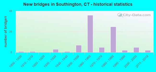
- New bridges - historical statistics
- 11900-1909
- 11910-1919
- 31930-1939
- 11940-1949
- 71950-1959
- 361960-1969
- 51970-1979
- 251980-1989
- 21990-1999
- 52000-2009
- 22010-2019

- Reconstructed bridges - Historical Statistics
- 11920-1929
- 01930-1939
- 01940-1949
- 01950-1959
- 01960-1969
- 11970-1979
- 51980-1989
- 71990-1999
- 42000-2009
- 22010-2019


- Bridge Condition - Deck
- 56.8%Good
- 25.0%Satisfactory
- 13.6%Fair
- 2.3%Poor
- 2.3%Serious

- Bridge Condition - Superstructure
- 2.2%Very good
- 32.6%Good
- 41.3%Satisfactory
- 17.4%Fair
- 6.5%Poor

- Bridge Condition - Substructure
- 2.2%Very good
- 41.3%Good
- 43.5%Satisfactory
- 13.0%Fair

- Bridge Condition - Channel
- 35.3%Good
- 52.9%Satisfactory
- 8.8%Fair
- 2.9%Failed

- Bridge Condition - Culverts
- 43.8%Good
- 31.3%Satisfactory
- 18.8%Fair
- 6.3%Failed
Find on map >> Show street view
Structure Number: 124, Location: 0.5 MI N OF ROUTE 113 (Lat: 41.176628, Lng: -73.150167), Route carried "on" structure: Interstate 95, Year Built: 1959, Year Reconstructed: 1995, Status: Open, Structure Length: 3.05m (10.01ft), Average Daily Traffic: 120,300 (year 2017), Truck Traffic: 9%, Average Future Daily Traffic: 178,754 (year 2037), Design Load: H 20, Features Intersected: STAGG STREET
Minimum Vertical Clearance: 30+ m (98+ ft), Kilometerpoint: 50.807, Lanes on structure: 6, Lanes under structure: 2, Base Highway Network: Yes, Owner: State Highway Agency, Approaching Roadway Width: 29.3m (96.1ft), Skew: 31 degrees, Material/Design: Steel, Design/Construction: Stringer/Multi-beam, Number Of Spans In Main Unit: 1, Length of Maximum Span: 29.0m (95.1ft), Curb-To-Curb Width: 35.9m (117.8ft), Out-to-Out Width: 38.9m (127.6ft)
Condition: Deck: Satisfactory, Superstructure: Good, Substructure: Satisfactory, Operating Rating: 77.8 metric tons, Method Used To Determine Operating Rating: Load Factor (LF), Inventory Rating: 46.7 metric tons, Method Used To Determine Inventory Rating: Load Factor (LF), Structural Evaluation: Equal to present minimum criteria, Deck Geometry: Superior to present desirable criteria, Underclear: Meets minimum limits, Approach Roadway Alignment: Equal to present desirable criteria, Designated Inspection Frequency: Every 24 months, Inspection Date: July 2020, Deck Structure Type: Concrete Cast-file-Place, Wearing Surface/Protective System: Wearing Surface: Bituminous, Membrane: Preformed Fabric, Deck Protection: Epoxy Coated Reinforcing
Find on map >> Show street view
Structure Number: 169, Location: EXIT 47 OFF I-95 NB (Lat: 41.298744, Lng: -72.915753), Route carried "on" structure: Ramp Interstate 95, Year Built: 2011, Status: Open, Structure Length: 57.76m (189.50ft), Average Daily Traffic: 6,300 (year 2017), Truck Traffic: 9%, Average Future Daily Traffic: 9,361 (year 2037), Design Load: HS 20, Features Intersected: I-95, I-91 TR801, Ramps
Minimum Vertical Clearance: 30+ m (98+ ft), Kilometerpoint: 0.483, Lanes on structure: 1, Lanes under structure: 20, Owner: State Highway Agency, Approaching Roadway Width: 7.9m (25.9ft), Skew: 1 degrees, Material/Design: Steel continuous, Design/Construction: Box Beam or Girders - Single/Spread, Number Of Spans In Main Unit: 8, Length of Maximum Span: 85.0m (278.9ft), Curb-To-Curb Width: 7.8m (25.6ft), Out-to-Out Width: 8.9m (29.2ft)
Condition: Deck: Good, Superstructure: Good, Substructure: Good, Operating Rating: 74.4 metric tons, Method Used To Determine Operating Rating: Load Factor (LF), Inventory Rating: 44.4 metric tons, Method Used To Determine Inventory Rating: Load Factor (LF), Structural Evaluation: Better than present minimum criteria, Deck Geometry: Better than present minimum criteria, Underclear: Somewhat better than minimum adequacy, Approach Roadway Alignment: Equal to present desirable criteria, Designated Inspection Frequency: Every 24 months, Critical Feature Inspection Frequency: Every 24 months, Inspection Date: June 2021, Critical Feature Inspection Date: June 2021, Deck Structure Type: Concrete Cast-file-Place, Wearing Surface/Protective System: Wearing Surface: Bituminous, Membrane: Built-up, Deck Protection: Epoxy Coated Reinforcing
Find on map >> Show street view
Structure Number: 456, Location: 1.3 MI EAST CT NY SL (Lat: 41.393406, Lng: -73.517414), Route carried "on" structure: US 6, Year Built: 1950, Year Reconstructed: 1987, Status: Open, Structure Length: 4.85m (15.91ft), Average Daily Traffic: 17,200 (year 2018), Truck Traffic: 6%, Average Future Daily Traffic: 25,557 (year 2038), Design Load: HS 20, Features Intersected: DNBY TERM/HOUSATONIC RR
Minimum Vertical Clearance: 30+ m (98+ ft), Kilometerpoint: 2.092, Lanes on structure: 3, Owner: State Highway Agency, Approaching Roadway Width: 16.5m (54.1ft), Skew: 4 degrees, Material/Design: Steel, Design/Construction: Stringer/Multi-beam, Number Of Spans In Main Unit: 3, Length of Maximum Span: 15.2m (49.9ft), Curb or Sidewalk Widths: Left: 0.0m, Right: 1.7m (5.6ft), Curb-To-Curb Width: 16.5m (54.1ft), Out-to-Out Width: 19.1m (62.7ft)
Condition: Deck: Good, Superstructure: Fair, Substructure: Satisfactory, Operating Rating: 97.9 metric tons, Method Used To Determine Operating Rating: Load Factor (LF), Inventory Rating: 58.8 metric tons, Method Used To Determine Inventory Rating: Load Factor (LF), Structural Evaluation: Somewhat better than minimum adequacy, Deck Geometry: Better than present minimum criteria, Underclear: High priority of corrective action, Approach Roadway Alignment: Better than present minimum criteria, Designated Inspection Frequency: Every 24 months, Inspection Date: September 2020, Deck Structure Type: Concrete Cast-file-Place, Wearing Surface/Protective System: Wearing Surface: Bituminous, Membrane: Preformed Fabric, Deck Protection: Epoxy Coated Reinforcing
Find on map >> Show street view
Structure Number: 516, Location: EXIT 28 OFF I-84 (Lat: 41.563314, Lng: -72.914033), Route carried "on" structure: State highway 322, Year Built: 1963, Status: Open, Structure Length: 6.61m (21.69ft), Average Daily Traffic: 16,000 (year 2015), Truck Traffic: 5%, Average Future Daily Traffic: 23,774 (year 2035), Design Load: HS 20, Features Intersected: INTERSTATE-84 & RAMPS
Minimum Vertical Clearance: 30+ m (98+ ft), Kilometerpoint: 9.849, Lanes on structure: 4, Lanes under structure: 8, Base Highway Network: Yes, Owner: State Highway Agency, Approaching Roadway Width: 17.7m (58.1ft), Skew: 33 degrees, Material/Design: Steel, Design/Construction: Stringer/Multi-beam, Number Of Spans In Main Unit: 2, Length of Maximum Span: 31.8m (104.3ft), Curb or Sidewalk Widths: Left: 0.5m (1.6ft), Right: 0.5m (1.6ft), Curb-To-Curb Width: 17.7m (58.1ft), Out-to-Out Width: 21.2m (69.6ft)
Condition: Deck: Fair, Superstructure: Fair, Substructure: Fair, Operating Rating: 68.3 metric tons, Method Used To Determine Operating Rating: Load Factor (LF), Inventory Rating: 41.0 metric tons, Method Used To Determine Inventory Rating: Load Factor (LF), Structural Evaluation: Somewhat better than minimum adequacy, Deck Geometry: Somewhat better than minimum adequacy, Underclear: High priority of corrective action, Approach Roadway Alignment: Equal to present minimum criteria, Designated Inspection Frequency: Every 24 months, Inspection Date: Febuary 2020, Deck Structure Type: Concrete Cast-file-Place, Wearing Surface/Protective System: Wearing Surface: Bituminous, Membrane: Built-up
Find on map >> Show street view
Structure Number: 518, Location: ROUTE 10 OVER ROUTE 322 (Lat: 41.564847, Lng: -72.891081), Route carried "on" structure: State highway 10, Year Built: 1936, Year Reconstructed: 1987, Status: Open, Structure Length: 1.80m (5.91ft), Average Daily Traffic: 5,200 (year 2015), Truck Traffic: 6%, Average Future Daily Traffic: 7,727 (year 2035), Design Load: H 20, Features Intersected: ROUTE 322
Minimum Vertical Clearance: 30+ m (98+ ft), Kilometerpoint: 34.665, Lanes on structure: 2, Lanes under structure: 2, Base Highway Network: Yes, Owner: State Highway Agency, Approaching Roadway Width: 9.1m (29.9ft), Skew: 2 degrees, Material/Design: Concrete, Design/Construction: Frame, Number Of Spans In Main Unit: 1, Length of Maximum Span: 18.0m (59.1ft), Curb-To-Curb Width: 9.1m (29.9ft), Out-to-Out Width: 10.4m (34.1ft)
Condition: Deck: Good, Superstructure: Poor, Substructure: Satisfactory, Operating Rating: 67.1 metric tons, Method Used To Determine Operating Rating: Load Factor (LF), Inventory Rating: 39.9 metric tons, Method Used To Determine Inventory Rating: Load Factor (LF), Structural Evaluation: Meets minimum limits, Deck Geometry: High priority of corrective action, Underclear: High priority of replacement, Approach Roadway Alignment: Equal to present desirable criteria, Designated Inspection Frequency: Every 24 months, Other Special Inspection Frequency: Every 12 months, Inspection Date: May 2021, Other Special Inspection Date: May 2021, Total Project Cost: $4,600,000, Deck Structure Type: Concrete Cast-file-Place, Wearing Surface/Protective System: Wearing Surface: Bituminous
Find on map >> Show street view
Structure Number: 519, Location: SOUTHINGTON-CHESHIRE TL (Lat: 41.563142, Lng: -72.879675), Route carried "on" structure: State highway 322, Year Built: 1948, Status: Open, Structure Length: 1.92m (6.30ft), Average Daily Traffic: 10,700 (year 2016), Truck Traffic: 5%, Average Future Daily Traffic: 15,899 (year 2036), Design Load: H 20, Features Intersected: QUINNIPIAC RIVER
Minimum Vertical Clearance: 30+ m (98+ ft), Kilometerpoint: 12.762, Lanes on structure: 2, Owner: State Highway Agency, Approaching Roadway Width: 12.5m (41.0ft), Material/Design: Concrete continuous, Design/Construction: Culvert, Number Of Spans In Main Unit: 3, Length of Maximum Span: 6.1m (20.0ft), Curb-To-Curb Width: 12.2m (40.0ft), Out-to-Out Width: 13.7m (44.9ft)
Condition: Channel: Fair, Culverts: Satisfactory, Operating Rating: 34.7 metric tons, Method Used To Determine Operating Rating: Load and Resistance Factor Rating (LRFR) rating reported by rating factor(RF) method using HL-93 loadings, Inventory Rating: 26.6 metric tons, Method Used To Determine Inventory Rating: Load and Resistance Factor Rating (LRFR) rating reported by rating factor(RF) method using HL-93 loadings, Structural Evaluation: Equal to present minimum criteria, Deck Geometry: Somewhat better than minimum adequacy, Waterway Adequacy: Meets minimum limits, Approach Roadway Alignment: Equal to present desirable criteria, Designated Inspection Frequency: Every 24 months, Underwater Inspection Frequency: Every 24 months, Inspection Date: August 2020, Underwater Inspection Date: August 2020, Deck Structure Type: Concrete Cast-file-Place, Wearing Surface/Protective System: Wearing Surface: Bituminous
Find on map >> Show street view
Structure Number: 533, Location: 0.4 MI N OF ROUTE 107 (Lat: 41.260736, Lng: -73.436211), Route carried "on" structure: US 7, Year Built: 1957, Status: Open, Structure Length: 1.34m (4.40ft), Average Daily Traffic: 21,500 (year 2017), Truck Traffic: 6%, Average Future Daily Traffic: 31,947 (year 2037), Design Load: HS 20, Features Intersected: NORWALK RIVER
Minimum Vertical Clearance: 30+ m (98+ ft), Kilometerpoint: 19.328, Lanes on structure: 2, Base Highway Network: Yes, Owner: State Highway Agency, Approaching Roadway Width: 9.4m (30.8ft), Material/Design: Prestressed concrete, Design/Construction: Slab, Number Of Spans In Main Unit: 1, Length of Maximum Span: 12.2m (40.0ft), Curb-To-Curb Width: 12.3m (40.4ft), Out-to-Out Width: 14.1m (46.3ft)
Condition: Deck: Satisfactory, Superstructure: Satisfactory, Substructure: Satisfactory, Channel: Good, Operating Rating: 70.8 metric tons, Method Used To Determine Operating Rating: Load Factor (LF), Inventory Rating: 42.4 metric tons, Method Used To Determine Inventory Rating: Load Factor (LF), Structural Evaluation: Equal to present minimum criteria, Deck Geometry: Somewhat better than minimum adequacy, Waterway Adequacy: Superior to present desirable criteria, Approach Roadway Alignment: Equal to present minimum criteria, Designated Inspection Frequency: Every 24 months, Inspection Date: March 2020, Deck Structure Type: Other, Wearing Surface/Protective System: Wearing Surface: Bituminous, Membrane: Preformed Fabric
Find on map >> Show street view
Structure Number: 646, Location: 300FT SO OF JCT ROUTE 322 (Lat: 41.564381, Lng: -72.890703), Route carried "on" structure: State highway 10, Year Built: 1936, Status: Open, Structure Length: 0.91m (2.99ft), Average Daily Traffic: 5,200 (year 2015), Truck Traffic: 6%, Average Future Daily Traffic: 7,727 (year 2035), Design Load: H 20, Features Intersected: TEN MILE RIVER
Minimum Vertical Clearance: 30+ m (98+ ft), Kilometerpoint: 34.633, Lanes on structure: 2, Base Highway Network: Yes, Owner: State Highway Agency, Approaching Roadway Width: 8.5m (27.9ft), Material/Design: Concrete, Design/Construction: Arch - Deck, Number Of Spans In Main Unit: 1, Length of Maximum Span: 9.1m (29.9ft)
Condition: Superstructure: Satisfactory, Substructure: Fair, Channel: Fair, Structural Evaluation: Somewhat better than minimum adequacy, Waterway Adequacy: Equal to present desirable criteria, Approach Roadway Alignment: Equal to present desirable criteria, Designated Inspection Frequency: Every 24 months, Underwater Inspection Frequency: Every 24 months, Inspection Date: July 2020, Underwater Inspection Date: July 2020
Find on map >> Show street view
Structure Number: 648, Location: AT EXIT 32 INTERSTATE 84 (Lat: 41.631789, Lng: -72.873639), Route carried "on" structure: Interstate 84, Year Built: 1963, Year Reconstructed: 1997, Status: Open, Structure Length: 7.40m (24.28ft), Average Daily Traffic: 41,950 (year 2018), Truck Traffic: 9%, Average Future Daily Traffic: 62,334 (year 2038), Design Load: HS 20, Features Intersected: ROUTE 10
Minimum Vertical Clearance: 30+ m (98+ ft), Kilometerpoint: 74.400, Lanes on structure: 4, Lanes under structure: 4, Base Highway Network: Yes, Owner: State Highway Agency, Approaching Roadway Width: 18.6m (61.0ft), Skew: 4 degrees, Material/Design: Steel continuous, Design/Construction: Stringer/Multi-beam, Number Of Spans In Main Unit: 4, Length of Maximum Span: 21.0m (68.9ft), Curb-To-Curb Width: 19.2m (63.0ft), Out-to-Out Width: 20.3m (66.6ft)
Condition: Deck: Good, Superstructure: Good, Substructure: Satisfactory, Operating Rating: 89.8 metric tons, Method Used To Determine Operating Rating: Load Factor (LF), Inventory Rating: 53.5 metric tons, Method Used To Determine Inventory Rating: Load Factor (LF), Structural Evaluation: Equal to present minimum criteria, Deck Geometry: Somewhat better than minimum adequacy, Underclear: Somewhat better than minimum adequacy, Approach Roadway Alignment: Equal to present desirable criteria, Designated Inspection Frequency: Every 24 months, Inspection Date: December 2020, Deck Structure Type: Concrete Cast-file-Place, Wearing Surface/Protective System: Wearing Surface: Bituminous, Membrane: Preformed Fabric, Deck Protection: Epoxy Coated Reinforcing
Find on map >> Show street view
Structure Number: 649, Location: INTERSTATE-84 EXIT NO. 32 (Lat: 41.632375, Lng: -72.873642), Route carried "on" structure: Interstate 84, Year Built: 1963, Status: Open, Structure Length: 7.02m (23.03ft), Average Daily Traffic: 41,950 (year 2018), Truck Traffic: 9%, Average Future Daily Traffic: 62,334 (year 2038), Design Load: HS 20, Features Intersected: ROUTE 10
Minimum Vertical Clearance: 30+ m (98+ ft), Kilometerpoint: 74.432, Lanes on structure: 4, Lanes under structure: 4, Base Highway Network: Yes, Owner: State Highway Agency, Approaching Roadway Width: 19.2m (63.0ft), Skew: 4 degrees, Material/Design: Steel, Design/Construction: Stringer/Multi-beam, Number Of Spans In Main Unit: 4, Length of Maximum Span: 21.0m (68.9ft), Curb-To-Curb Width: 19.2m (63.0ft), Out-to-Out Width: 20.3m (66.6ft)
Condition: Deck: Fair, Superstructure: Fair, Substructure: Satisfactory, Operating Rating: 45.4 metric tons, Method Used To Determine Operating Rating: Load and Resistance Factor Rating (LRFR) rating reported by rating factor(RF) method using HL-93 loadings, Inventory Rating: 35.0 metric tons, Method Used To Determine Inventory Rating: Load and Resistance Factor Rating (LRFR) rating reported by rating factor(RF) method using HL-93 loadings, Structural Evaluation: Somewhat better than minimum adequacy, Deck Geometry: Somewhat better than minimum adequacy, Underclear: Somewhat better than minimum adequacy, Approach Roadway Alignment: Equal to present desirable criteria, Designated Inspection Frequency: Every 24 months, Inspection Date: December 2020, Deck Structure Type: Concrete Cast-file-Place, Wearing Surface/Protective System: Wearing Surface: Bituminous, Membrane: Built-up
Find on map >> Show street view
Structure Number: 1232, Location: 0.3 MI W OF ROUTE 322 (Lat: 41.559872, Lng: -72.917236), Route carried "on" structure: Interstate 84, Year Built: 1961, Year Reconstructed: 1984, Status: Open, Structure Length: 0.98m (3.22ft), Average Daily Traffic: 66,400 (year 2018), Truck Traffic: 9%, Average Future Daily Traffic: 98,664 (year 2038), Design Load: HS 20, Features Intersected: JUDD BROOK
Minimum Vertical Clearance: 30+ m (98+ ft), Kilometerpoint: 65.001, Lanes on structure: 9, Base Highway Network: Yes, Owner: State Highway Agency, Approaching Roadway Width: 44.2m (145.0ft), Skew: 30 degrees, Material/Design: Concrete continuous, Design/Construction: Culvert, Number Of Spans In Main Unit: 3, Length of Maximum Span: 3.0m (9.8ft)
Condition: Channel: Good, Culverts: Good, Operating Rating: 56.4 metric tons, Method Used To Determine Operating Rating: Load and Resistance Factor Rating (LRFR) rating reported by rating factor(RF) method using HL-93 loadings, Inventory Rating: 43.4 metric tons, Method Used To Determine Inventory Rating: Load and Resistance Factor Rating (LRFR) rating reported by rating factor(RF) method using HL-93 loadings, Structural Evaluation: Better than present minimum criteria, Waterway Adequacy: Equal to present desirable criteria, Approach Roadway Alignment: Equal to present desirable criteria, Designated Inspection Frequency: Every 24 months, Inspection Date: October 2021
Find on map >> Show street view
Structure Number: 1233, Location: 0.5 MI NORTH RT 322 (Lat: 41.568747, Lng: -72.909822), Route carried "on" structure: City street , Year Built: 2005, Status: Open, Structure Length: 7.32m (24.02ft), Average Daily Traffic: 1,632 (year 2018), Truck Traffic: 4%, Average Future Daily Traffic: 2,425 (year 2038), Design Load: HL 93, Features Intersected: INTERSTATE-84, Facility Carried by Structure: BURRITT STREET
Minimum Vertical Clearance: 30+ m (98+ ft), Kilometerpoint: 1.159, Lanes on structure: 2, Lanes under structure: 6, Owner: State Highway Agency, Approaching Roadway Width: 9.1m (29.9ft), Skew: 3 degrees, Material/Design: Prestressed concrete continuous, Design/Construction: Stringer/Multi-beam, Number Of Spans In Main Unit: 2, Length of Maximum Span: 36.0m (118.1ft), Curb or Sidewalk Widths: Left: 0.0m, Right: 2.0m (6.6ft), Curb-To-Curb Width: 8.5m (27.9ft), Out-to-Out Width: 12.5m (41.0ft)
Condition: Deck: Good, Superstructure: Satisfactory, Substructure: Satisfactory, Operating Rating: 40.2 metric tons, Method Used To Determine Operating Rating: Load and Resistance Factor Rating (LRFR) rating reported by rating factor(RF) method using HL-93 loadings, Inventory Rating: 30.8 metric tons, Method Used To Determine Inventory Rating: Load and Resistance Factor Rating (LRFR) rating reported by rating factor(RF) method using HL-93 loadings, Structural Evaluation: Equal to present minimum criteria, Underclear: High priority of corrective action, Approach Roadway Alignment: Equal to present minimum criteria, Designated Inspection Frequency: Every 24 months, Inspection Date: October 2020, Deck Structure Type: Concrete Cast-file-Place, Wearing Surface/Protective System: Wearing Surface: Bituminous, Membrane: Built-up, Deck Protection: Epoxy Coated Reinforcing
Find on map >> Show street view
Structure Number: 1234, Location: EXIT 29, I-84 WB (Lat: 41.578439, Lng: -72.901422), Route carried "on" structure: Ramp State highway 597, Year Built: 2005, Status: Open, Structure Length: 7.53m (24.70ft), Average Daily Traffic: 8,300 (year 2015), Truck Traffic: 6%, Average Future Daily Traffic: 12,333 (year 2035), Design Load: HS 20, Features Intersected: I-84 EB
Minimum Vertical Clearance: 30+ m (98+ ft), Kilometerpoint: 0.692, Lanes on structure: 1, Lanes under structure: 3, Owner: State Highway Agency, Approaching Roadway Width: 7.9m (25.9ft), Material/Design: Steel, Design/Construction: Stringer/Multi-beam, Number Of Spans In Main Unit: 1, Length of Maximum Span: 73.2m (240.2ft), Curb-To-Curb Width: 7.8m (25.6ft), Out-to-Out Width: 8.9m (29.2ft)
Condition: Deck: Good, Superstructure: Good, Substructure: Good, Inventory Rating: 92.4 metric tons, Method Used To Determine Inventory Rating: Load Factor (LF), Structural Evaluation: Better than present minimum criteria, Deck Geometry: Better than present minimum criteria, Underclear: Better than present minimum criteria, Approach Roadway Alignment: Equal to present desirable criteria, Designated Inspection Frequency: Every 24 months, Inspection Date: October 2020, Deck Structure Type: Concrete Cast-file-Place, Wearing Surface/Protective System: Wearing Surface: Bituminous, Membrane: Built-up, Deck Protection: Epoxy Coated Reinforcing
Find on map >> Show street view
Structure Number: 1235, Location: INTERSTATE 84 AT EXIT 30 (Lat: 41.586961, Lng: -72.899303), Route carried "on" structure: Interstate 84, Year Built: 1963, Year Reconstructed: 2014, Status: Open, Structure Length: 3.26m (10.70ft), Average Daily Traffic: 45,950 (year 2018), Truck Traffic: 14%, Average Future Daily Traffic: 68,277 (year 2038), Design Load: HL 93, Features Intersected: MARION AVENUE
Minimum Vertical Clearance: 30+ m (98+ ft), Kilometerpoint: 68.429, Lanes on structure: 3, Lanes under structure: 2, Base Highway Network: Yes, Owner: State Highway Agency, Approaching Roadway Width: 16.2m (53.1ft), Skew: 1 degrees, Material/Design: Prestressed concrete, Design/Construction: Stringer/Multi-beam, Number Of Spans In Main Unit: 1, Length of Maximum Span: 31.1m (102.0ft), Curb-To-Curb Width: 16.1m (52.8ft), Out-to-Out Width: 17.3m (56.8ft)
Condition: Deck: Good, Superstructure: Good, Substructure: Good, Operating Rating: 58.0 metric tons, Method Used To Determine Operating Rating: Load and Resistance Factor Rating (LRFR) rating reported by rating factor(RF) method using HL-93 loadings, Inventory Rating: 39.9 metric tons, Method Used To Determine Inventory Rating: Load and Resistance Factor Rating (LRFR) rating reported by rating factor(RF) method using HL-93 loadings, Structural Evaluation: Better than present minimum criteria, Deck Geometry: Equal to present minimum criteria, Underclear: High priority of corrective action, Approach Roadway Alignment: Equal to present desirable criteria, Designated Inspection Frequency: Every 24 months, Inspection Date: July 2020, Deck Structure Type: Concrete Cast-file-Place, Wearing Surface/Protective System: Wearing Surface: Bituminous, Membrane: Built-up, Deck Protection: Epoxy Coated Reinforcing
Find on map >> Show street view
Structure Number: 1236, Location: INTERSTATE-84 EXIT NO. 30 (Lat: 41.586711, Lng: -72.899622), Route carried "on" structure: Interstate 84, Year Built: 1963, Year Reconstructed: 2014, Status: Open, Structure Length: 3.30m (10.83ft), Average Daily Traffic: 45,950 (year 2018), Truck Traffic: 14%, Average Future Daily Traffic: 68,277 (year 2038), Design Load: HL 93, Features Intersected: MARION AVENUE
Minimum Vertical Clearance: 30+ m (98+ ft), Kilometerpoint: 68.429, Lanes on structure: 3, Lanes under structure: 3, Base Highway Network: Yes, Owner: State Highway Agency, Approaching Roadway Width: 16.2m (53.1ft), Skew: 2 degrees, Material/Design: Prestressed concrete, Design/Construction: Stringer/Multi-beam, Number Of Spans In Main Unit: 1, Length of Maximum Span: 31.4m (103.0ft), Curb-To-Curb Width: 16.1m (52.8ft), Out-to-Out Width: 17.3m (56.8ft)
Condition: Deck: Good, Superstructure: Good, Substructure: Good, Operating Rating: 56.4 metric tons, Method Used To Determine Operating Rating: Load and Resistance Factor Rating (LRFR) rating reported by rating factor(RF) method using HL-93 loadings, Inventory Rating: 37.9 metric tons, Method Used To Determine Inventory Rating: Load and Resistance Factor Rating (LRFR) rating reported by rating factor(RF) method using HL-93 loadings, Structural Evaluation: Better than present minimum criteria, Deck Geometry: Equal to present minimum criteria, Underclear: High priority of corrective action, Approach Roadway Alignment: Equal to present desirable criteria, Designated Inspection Frequency: Every 24 months, Inspection Date: July 2020, Deck Structure Type: Concrete Cast-file-Place, Wearing Surface/Protective System: Wearing Surface: Bituminous, Membrane: Built-up, Deck Protection: Epoxy Coated Reinforcing
Find on map >> Show street view
Structure Number: 1237, Location: .4 MI EAST OF EXIT 30 (Lat: 41.591789, Lng: -72.902842), Route carried "on" structure: City street , Year Built: 1961, Year Reconstructed: 1992, Status: Open, Structure Length: 6.46m (21.19ft), Average Daily Traffic: 4,724 (year 2020), Truck Traffic: 2%, Average Future Daily Traffic: 7,019 (year 2040), Design Load: HS 20, Features Intersected: INTERSTATE-84, Facility Carried by Structure: PROSPECT STREET
Minimum Vertical Clearance: 30+ m (98+ ft), Kilometerpoint: 1.931, Lanes on structure: 2, Lanes under structure: 6, Owner: State Highway Agency, Approaching Roadway Width: 10.7m (35.1ft), Material/Design: Prestressed concrete, Design/Construction: Stringer/Multi-beam, Number Of Spans In Main Unit: 2, Length of Maximum Span: 31.6m (103.7ft), Curb or Sidewalk Widths: Left: 0.0m, Right: 1.7m (5.6ft), Curb-To-Curb Width: 10.6m (34.8ft), Out-to-Out Width: 13.3m (43.6ft)
Condition: Deck: Satisfactory, Superstructure: Fair, Substructure: Satisfactory, Operating Rating: 52.2 metric tons, Method Used To Determine Operating Rating: Load and Resistance Factor Rating (LRFR) rating reported by rating factor(RF) method using HL-93 loadings, Inventory Rating: 38.9 metric tons, Method Used To Determine Inventory Rating: Load and Resistance Factor Rating (LRFR) rating reported by rating factor(RF) method using HL-93 loadings, Structural Evaluation: Somewhat better than minimum adequacy, Deck Geometry: Somewhat better than minimum adequacy, Underclear: Meets minimum limits, Approach Roadway Alignment: Better than present minimum criteria, Designated Inspection Frequency: Every 24 months, Inspection Date: January 2020, Deck Structure Type: Concrete Cast-file-Place, Wearing Surface/Protective System: Wearing Surface: Bituminous, Membrane: Preformed Fabric, Deck Protection: Epoxy Coated Reinforcing
Find on map >> Show street view
Structure Number: 1238, Location: 0.8 MI E OF I-84 EXIT 30 (Lat: 41.597286, Lng: -72.903500), Route carried "on" structure: Interstate 84, Year Built: 1963, Status: Open, Structure Length: 2.59m (8.50ft), Average Daily Traffic: 49,000 (year 2018), Truck Traffic: 9%, Average Future Daily Traffic: 72,809 (year 2038), Design Load: HS 20, Features Intersected: WEST CENTER STREET EXT.
Minimum Vertical Clearance: 30+ m (98+ ft), Kilometerpoint: 69.652, Lanes on structure: 3, Lanes under structure: 2, Base Highway Network: Yes, Owner: State Highway Agency, Approaching Roadway Width: 15.5m (50.9ft), Skew: 1 degrees, Material/Design: Steel, Design/Construction: Stringer/Multi-beam, Number Of Spans In Main Unit: 1, Length of Maximum Span: 24.4m (80.1ft), Curb-To-Curb Width: 15.5m (50.9ft), Out-to-Out Width: 17.2m (56.4ft)
Condition: Deck: Satisfactory, Superstructure: Satisfactory, Substructure: Satisfactory, Operating Rating: 61.9 metric tons, Method Used To Determine Operating Rating: Load and Resistance Factor Rating (LRFR) rating reported by rating factor(RF) method using HL-93 loadings, Inventory Rating: 47.6 metric tons, Method Used To Determine Inventory Rating: Load and Resistance Factor Rating (LRFR) rating reported by rating factor(RF) method using HL-93 loadings, Structural Evaluation: Equal to present minimum criteria, Deck Geometry: Somewhat better than minimum adequacy, Underclear: High priority of corrective action, Approach Roadway Alignment: Equal to present desirable criteria, Designated Inspection Frequency: Every 24 months, Inspection Date: April 2020, Deck Structure Type: Concrete Cast-file-Place, Wearing Surface/Protective System: Wearing Surface: Bituminous, Membrane: Built-up
Find on map >> Show street view
Structure Number: 1239, Location: 0.8 MI E OF I-84 EXIT 30 (Lat: 41.597350, Lng: -72.902947), Route carried "on" structure: Interstate 84, Year Built: 1963, Status: Open, Structure Length: 2.59m (8.50ft), Average Daily Traffic: 49,650 (year 2018), Truck Traffic: 9%, Average Future Daily Traffic: 73,775 (year 2038), Design Load: HS 20, Features Intersected: WEST CENTER STREET EXT.
Minimum Vertical Clearance: 30+ m (98+ ft), Kilometerpoint: 69.669, Lanes on structure: 3, Lanes under structure: 2, Base Highway Network: Yes, Owner: State Highway Agency, Approaching Roadway Width: 15.5m (50.9ft), Skew: 11 degrees, Material/Design: Steel, Design/Construction: Stringer/Multi-beam, Number Of Spans In Main Unit: 1, Length of Maximum Span: 24.4m (80.1ft), Curb-To-Curb Width: 15.5m (50.9ft), Out-to-Out Width: 17.2m (56.4ft)
Condition: Deck: Fair, Superstructure: Satisfactory, Substructure: Satisfactory, Operating Rating: 61.6 metric tons, Method Used To Determine Operating Rating: Load and Resistance Factor Rating (LRFR) rating reported by rating factor(RF) method using HL-93 loadings, Inventory Rating: 47.6 metric tons, Method Used To Determine Inventory Rating: Load and Resistance Factor Rating (LRFR) rating reported by rating factor(RF) method using HL-93 loadings, Structural Evaluation: Equal to present minimum criteria, Deck Geometry: Somewhat better than minimum adequacy, Underclear: Meets minimum limits, Approach Roadway Alignment: Equal to present desirable criteria, Designated Inspection Frequency: Every 24 months, Inspection Date: April 2020, Deck Structure Type: Concrete Cast-file-Place, Wearing Surface/Protective System: Wearing Surface: Bituminous, Membrane: Built-up
Find on map >> Show street view
Structure Number: 124, Location: 1.0 MI E OF ROUTE 229 (Lat: 41.598242, Lng: -72.903022), Route carried "on" structure: Interstate 84, Year Built: 1963, Status: Open, Structure Length: 1.77m (5.81ft), Average Daily Traffic: 99,300 (year 2018), Truck Traffic: 9%, Average Future Daily Traffic: 147,550 (year 2038), Features Intersected: EIGHT MILE RIVER
Minimum Vertical Clearance: 30+ m (98+ ft), Kilometerpoint: 69.749, Lanes on structure: 6, Base Highway Network: Yes, Owner: State Highway Agency, Approaching Roadway Width: 31.1m (102.0ft), Skew: 23 degrees, Material/Design: Concrete continuous, Design/Construction: Culvert, Number Of Spans In Main Unit: 3, Length of Maximum Span: 5.5m (18.0ft)
Condition: Channel: Satisfactory, Culverts: Fair, Structural Evaluation: Somewhat better than minimum adequacy, Waterway Adequacy: Equal to present desirable criteria, Approach Roadway Alignment: Equal to present desirable criteria, Designated Inspection Frequency: Every 24 months, Inspection Date: May 2020
Find on map >> Show street view
Structure Number: 1241, Location: 0.4 MI W OF I-84 EXIT 31 (Lat: 41.606342, Lng: -72.901528), Route carried "on" structure: City street , Year Built: 1963, Year Reconstructed: 1994, Status: Open, Structure Length: 6.49m (21.29ft), Average Daily Traffic: 7,614 (year 2020), Truck Traffic: 3%, Average Future Daily Traffic: 11,314 (year 2040), Design Load: HS 20, Features Intersected: INTERSTATE-84, Facility Carried by Structure: JUDE LANE
Minimum Vertical Clearance: 30+ m (98+ ft), Kilometerpoint: 2.012, Lanes on structure: 2, Lanes under structure: 6, Owner: State Highway Agency, Approaching Roadway Width: 10.7m (35.1ft), Skew: 1 degrees, Material/Design: Prestressed concrete, Design/Construction: Stringer/Multi-beam, Number Of Spans In Main Unit: 2, Length of Maximum Span: 31.4m (103.0ft), Curb or Sidewalk Widths: Left: 0.0m, Right: 1.7m (5.6ft), Curb-To-Curb Width: 10.6m (34.8ft), Out-to-Out Width: 13.3m (43.6ft)
Condition: Deck: Good, Superstructure: Fair, Substructure: Satisfactory, Operating Rating: 72.8 metric tons, Method Used To Determine Operating Rating: Load Factor (LF), Inventory Rating: 43.6 metric tons, Method Used To Determine Inventory Rating: Load Factor (LF), Structural Evaluation: Somewhat better than minimum adequacy, Deck Geometry: Meets minimum limits, Underclear: Meets minimum limits, Approach Roadway Alignment: Equal to present desirable criteria, Designated Inspection Frequency: Every 24 months, Inspection Date: April 2020, Deck Structure Type: Concrete Cast-file-Place, Wearing Surface/Protective System: Wearing Surface: Bituminous, Membrane: Preformed Fabric, Deck Protection: Epoxy Coated Reinforcing
Find on map >> Show street view
Structure Number: 1242, Location: AT INTERSTATE-84 EXIT 31 (Lat: 41.612214, Lng: -72.898992), Route carried "on" structure: State highway 229, Year Built: 1963, Year Reconstructed: 1990, Status: Open, Structure Length: 12.49m (40.98ft), Average Daily Traffic: 20,500 (year 2015), Truck Traffic: 6%, Average Future Daily Traffic: 30,461 (year 2035), Design Load: HS 20, Features Intersected: INTERSTATE-84
Minimum Vertical Clearance: 30+ m (98+ ft), Kilometerpoint: 0.097, Lanes on structure: 4, Lanes under structure: 6, Base Highway Network: Yes, Owner: State Highway Agency, Approaching Roadway Width: 16.5m (54.1ft), Skew: 5 degrees, Material/Design: Steel, Design/Construction: Stringer/Multi-beam, Number Of Spans In Main Unit: 5, Length of Maximum Span: 35.8m (117.5ft), Curb or Sidewalk Widths: Left: 1.5m (4.9ft), Right: 1.5m (4.9ft), Curb-To-Curb Width: 16.5m (54.1ft), Out-to-Out Width: 20.3m (66.6ft)
Condition: Deck: Fair, Superstructure: Fair, Substructure: Fair, Operating Rating: 59.9 metric tons, Method Used To Determine Operating Rating: Load Factor (LF), Inventory Rating: 35.4 metric tons, Method Used To Determine Inventory Rating: Load Factor (LF), Structural Evaluation: Somewhat better than minimum adequacy, Deck Geometry: Meets minimum limits, Underclear: Meets minimum limits, Approach Roadway Alignment: Equal to present minimum criteria, Designated Inspection Frequency: Every 24 months, Inspection Date: April 2020, Deck Structure Type: Concrete Cast-file-Place, Wearing Surface/Protective System: Wearing Surface: Monolithic Concrete, Deck Protection: Cathodic Protection
Find on map >> Show street view
Structure Number: 1247, Location: .2 MI W EXIT 32, ROUTE 10 (Lat: 41.630425, Lng: -72.876283), Route carried "on" structure: Interstate 84, Year Built: 1963, Year Reconstructed: 1996, Status: Open, Structure Length: 5.33m (17.49ft), Average Daily Traffic: 45,750 (year 2018), Truck Traffic: 9%, Average Future Daily Traffic: 67,980 (year 2038), Design Load: HS 20, Features Intersected: ABANDONED B&M RAILROAD
Minimum Vertical Clearance: 30+ m (98+ ft), Kilometerpoint: 74.142, Lanes on structure: 4, Base Highway Network: Yes, Owner: State Highway Agency, Approaching Roadway Width: 20.1m (65.9ft), Skew: 14 degrees, Material/Design: Steel, Design/Construction: Stringer/Multi-beam, Number Of Spans In Main Unit: 3, Length of Maximum Span: 20.4m (66.9ft), Curb-To-Curb Width: 20.2m (66.3ft), Out-to-Out Width: 21.0m (68.9ft)
Condition: Deck: Fair, Superstructure: Satisfactory, Substructure: Good, Operating Rating: 79.5 metric tons, Method Used To Determine Operating Rating: Load Factor (LF), Inventory Rating: 47.7 metric tons, Method Used To Determine Inventory Rating: Load Factor (LF), Structural Evaluation: Equal to present minimum criteria, Deck Geometry: Equal to present minimum criteria, Approach Roadway Alignment: Equal to present desirable criteria, Designated Inspection Frequency: Every 24 months, Inspection Date: November 2020, Deck Structure Type: Concrete Cast-file-Place, Wearing Surface/Protective System: Wearing Surface: Bituminous, Membrane: Preformed Fabric
Find on map >> Show street view
Structure Number: 1326, Location: 1.5 MI N OF ROUTE 322 (Lat: 41.575722, Lng: -72.864931), Route carried "on" structure: State highway 120, Year Built: 1963, Status: Open, Structure Length: 0.61m (2.00ft), Average Daily Traffic: 7,500 (year 2020), Truck Traffic: 3%, Average Future Daily Traffic: 11,144 (year 2040), Design Load: HS 20, Features Intersected: MISERY BROOK
Minimum Vertical Clearance: 30+ m (98+ ft), Kilometerpoint: 2.382, Lanes on structure: 2, Owner: State Highway Agency, Approaching Roadway Width: 12.9m (42.3ft), Skew: 1 degrees, Material/Design: Concrete continuous, Design/Construction: Culvert, Number Of Spans In Main Unit: 2, Length of Maximum Span: 3.0m (9.8ft), Curb-To-Curb Width: 12.9m (42.3ft), Out-to-Out Width: 15.9m (52.2ft)
Condition: Channel: Good, Culverts: Good, Operating Rating: 66.1 metric tons, Method Used To Determine Operating Rating: Load and Resistance Factor Rating (LRFR) rating reported by rating factor(RF) method using HL-93 loadings, Inventory Rating: 50.9 metric tons, Method Used To Determine Inventory Rating: Load and Resistance Factor Rating (LRFR) rating reported by rating factor(RF) method using HL-93 loadings, Structural Evaluation: Better than present minimum criteria, Deck Geometry: Somewhat better than minimum adequacy, Waterway Adequacy: Equal to present desirable criteria, Approach Roadway Alignment: Equal to present desirable criteria, Designated Inspection Frequency: Every 24 months, Inspection Date: December 2021, Deck Structure Type: Other, Wearing Surface/Protective System: Wearing Surface: Bituminous, Membrane: Other
Find on map >> Show street view
Structure Number: 1689, Location: EXIT 29 INTERSTATE-84 WB (Lat: 41.574228, Lng: -72.898333), Route carried "on" structure: State highway 597, Year Built: 1963, Status: Open, Structure Length: 4.05m (13.29ft), Average Daily Traffic: 4,200 (year 2018), Truck Traffic: 6%, Average Future Daily Traffic: 6,241 (year 2038), Design Load: H 20, Features Intersected: QUINNIPIAC RIVER
Minimum Vertical Clearance: 30+ m (98+ ft), Kilometerpoint: 0.177, Lanes on structure: 1, Base Highway Network: Yes, Owner: State Highway Agency, Approaching Roadway Width: 7.0m (23.0ft), Skew: 2 degrees, Material/Design: Steel, Design/Construction: Stringer/Multi-beam, Number Of Spans In Main Unit: 1, Length of Maximum Span: 38.7m (127.0ft), Curb or Sidewalk Widths: Left: 0.5m (1.6ft), Right: 0.5m (1.6ft), Curb-To-Curb Width: 14.9m (48.9ft), Out-to-Out Width: 16.6m (54.5ft)
Condition: Deck: Satisfactory, Superstructure: Satisfactory, Substructure: Satisfactory, Channel: Good, Inventory Rating: 64.4 metric tons, Method Used To Determine Inventory Rating: Load Factor (LF), Structural Evaluation: Equal to present minimum criteria, Deck Geometry: Superior to present desirable criteria, Waterway Adequacy: Equal to present desirable criteria, Approach Roadway Alignment: Equal to present minimum criteria, Designated Inspection Frequency: Every 24 months, Inspection Date: April 2021, Deck Structure Type: Concrete Cast-file-Place, Wearing Surface/Protective System: Wearing Surface: Bituminous, Membrane: Preformed Fabric
Find on map >> Show street view
Structure Number: 169, Location: RAMP ROUTE 10 TO I-84 EB (Lat: 41.574622, Lng: -72.898181), Route carried "on" structure: State highway 597, Year Built: 1963, Year Reconstructed: 1991, Status: Open, Structure Length: 4.06m (13.32ft), Average Daily Traffic: 8,300 (year 2015), Truck Traffic: 8%, Average Future Daily Traffic: 12,333 (year 2035), Design Load: HS 20, Features Intersected: QUINNIPIAC RIVER
Minimum Vertical Clearance: 30+ m (98+ ft), Kilometerpoint: 0.193, Lanes on structure: 1, Base Highway Network: Yes, Owner: State Highway Agency, Approaching Roadway Width: 14.9m (48.9ft), Skew: 2 degrees, Material/Design: Steel, Design/Construction: Stringer/Multi-beam, Number Of Spans In Main Unit: 1, Length of Maximum Span: 38.7m (127.0ft), Curb or Sidewalk Widths: Left: 0.5m (1.6ft), Right: 0.5m (1.6ft), Curb-To-Curb Width: 14.9m (48.9ft), Out-to-Out Width: 16.6m (54.5ft)
Condition: Deck: Satisfactory, Superstructure: Satisfactory, Substructure: Satisfactory, Channel: Good, Operating Rating: 45.4 metric tons, Method Used To Determine Operating Rating: Load and Resistance Factor Rating (LRFR) rating reported by rating factor(RF) method using HL-93 loadings, Inventory Rating: 35.0 metric tons, Method Used To Determine Inventory Rating: Load and Resistance Factor Rating (LRFR) rating reported by rating factor(RF) method using HL-93 loadings, Structural Evaluation: Equal to present minimum criteria, Deck Geometry: Superior to present desirable criteria, Waterway Adequacy: Equal to present desirable criteria, Approach Roadway Alignment: Equal to present desirable criteria, Designated Inspection Frequency: Every 24 months, Inspection Date: April 2021, Deck Structure Type: Concrete Cast-file-Place, Wearing Surface/Protective System: Wearing Surface: Bituminous, Membrane: Preformed Fabric
Find on map >> Show street view
Structure Number: 1691, Location: 0.2 MI N OF ROUTE 10 (Lat: 41.575125, Lng: -72.899725), Route carried "on" structure: State highway 597, Year Built: 1963, Year Reconstructed: 1990, Status: Open, Structure Length: 6.58m (21.59ft), Average Daily Traffic: 4,150 (year 2015), Truck Traffic: 9%, Average Future Daily Traffic: 6,166 (year 2035), Design Load: HS 20, Features Intersected: CANAL ST, RAIL TO TRAIL
Minimum Vertical Clearance: 30+ m (98+ ft), Kilometerpoint: 0.322, Lanes on structure: 1, Lanes under structure: 2, Base Highway Network: Yes, Owner: State Highway Agency, Approaching Roadway Width: 12.5m (41.0ft), Skew: 3 degrees, Material/Design: Steel, Design/Construction: Stringer/Multi-beam, Number Of Spans In Main Unit: 4, Length of Maximum Span: 16.5m (54.1ft), Curb-To-Curb Width: 12.4m (40.7ft), Out-to-Out Width: 13.6m (44.6ft)
Condition: Deck: Good, Superstructure: Satisfactory, Substructure: Satisfactory, Operating Rating: 86.2 metric tons, Method Used To Determine Operating Rating: Load Factor (LF), Inventory Rating: 51.7 metric tons, Method Used To Determine Inventory Rating: Load Factor (LF), Structural Evaluation: Equal to present minimum criteria, Deck Geometry: Equal to present minimum criteria, Underclear: Meets minimum limits, Approach Roadway Alignment: Equal to present desirable criteria, Designated Inspection Frequency: Every 24 months, Inspection Date: Febuary 2021, Deck Structure Type: Concrete Cast-file-Place, Wearing Surface/Protective System: Wearing Surface: Bituminous, Membrane: Preformed Fabric, Deck Protection: Epoxy Coated Reinforcing
Find on map >> Show street view
Structure Number: 1692, Location: 0.2 MI N OF ROUTE 10 (Lat: 41.575758, Lng: -72.899522), Route carried "on" structure: State highway 597, Year Built: 1963, Year Reconstructed: 1990, Status: Open, Structure Length: 8.17m (26.80ft), Average Daily Traffic: 4,150 (year 2015), Truck Traffic: 5%, Average Future Daily Traffic: 6,166 (year 2035), Design Load: HS 20, Features Intersected: CANAL ST,RAILS TO TRAILS
Minimum Vertical Clearance: 30+ m (98+ ft), Kilometerpoint: 0.338, Lanes on structure: 1, Lanes under structure: 2, Base Highway Network: Yes, Owner: State Highway Agency, Approaching Roadway Width: 12.5m (41.0ft), Skew: 4 degrees, Material/Design: Steel, Design/Construction: Stringer/Multi-beam, Number Of Spans In Main Unit: 4, Length of Maximum Span: 21.3m (69.9ft), Curb-To-Curb Width: 12.4m (40.7ft), Out-to-Out Width: 13.6m (44.6ft)
Condition: Deck: Good, Superstructure: Fair, Substructure: Satisfactory, Operating Rating: 65.3 metric tons, Method Used To Determine Operating Rating: Load Factor (LF), Inventory Rating: 39.2 metric tons, Method Used To Determine Inventory Rating: Load Factor (LF), Structural Evaluation: Somewhat better than minimum adequacy, Deck Geometry: Equal to present minimum criteria, Underclear: Somewhat better than minimum adequacy, Approach Roadway Alignment: Equal to present desirable criteria, Designated Inspection Frequency: Every 24 months, Inspection Date: Febuary 2021, Deck Structure Type: Concrete Cast-file-Place, Wearing Surface/Protective System: Wearing Surface: Bituminous, Membrane: Preformed Fabric, Deck Protection: Epoxy Coated Reinforcing
Find on map >> Show street view
Structure Number: 1907, Location: INTERSTATE-691 EXIT NO. 4 (Lat: 41.554650, Lng: -72.847672), Route carried "on" structure: State highway 322, Year Built: 1971, Status: Open, Structure Length: 9.60m (31.50ft), Average Daily Traffic: 10,900 (year 2015), Truck Traffic: 5%, Average Future Daily Traffic: 16,196 (year 2035), Design Load: HS 20, Features Intersected: INTERSTATE-691
Minimum Vertical Clearance: 30+ m (98+ ft), Kilometerpoint: 15.611, Lanes on structure: 4, Lanes under structure: 5, Owner: State Highway Agency, Approaching Roadway Width: 14.6m (47.9ft), Skew: 4 degrees, Material/Design: Steel continuous, Design/Construction: Stringer/Multi-beam, Number Of Spans In Main Unit: 2, Length of Maximum Span: 46.6m (152.9ft), Curb or Sidewalk Widths: Left: 0.5m (1.6ft), Right: 1.8m (5.9ft), Curb-To-Curb Width: 14.6m (47.9ft), Out-to-Out Width: 17.7m (58.1ft)
Condition: Deck: Satisfactory, Superstructure: Satisfactory, Substructure: Satisfactory, Operating Rating: 69.1 metric tons, Method Used To Determine Operating Rating: Load Factor (LF), Inventory Rating: 41.5 metric tons, Method Used To Determine Inventory Rating: Load Factor (LF), Structural Evaluation: Equal to present minimum criteria, Deck Geometry: High priority of replacement, Underclear: Somewhat better than minimum adequacy, Approach Roadway Alignment: Equal to present minimum criteria, Designated Inspection Frequency: Every 24 months, Inspection Date: March 2020, Deck Structure Type: Concrete Cast-file-Place, Wearing Surface/Protective System: Wearing Surface: Bituminous, Membrane: Preformed Fabric
Find on map >> Show street view
Structure Number: 2254, Location: 0.8 MI N OF I-84 (Lat: 41.644064, Lng: -72.874058), Route carried "on" structure: State highway 10, Year Built: 1972, Status: Open, Structure Length: 0.94m (3.08ft), Average Daily Traffic: 16,100 (year 2015), Truck Traffic: 4%, Average Future Daily Traffic: 23,923 (year 2035), Design Load: HS 20, Features Intersected: QUINNIPIAC RIVER
Minimum Vertical Clearance: 30+ m (98+ ft), Kilometerpoint: 44.659, Lanes on structure: 4, Base Highway Network: Yes, Owner: State Highway Agency, Approaching Roadway Width: 16.2m (53.1ft), Skew: 1 degrees, Material/Design: Concrete continuous, Design/Construction: Culvert, Number Of Spans In Main Unit: 2, Length of Maximum Span: 4.6m (15.1ft), Curb or Sidewalk Widths: Left: 1.4m (4.6ft), Right: 1.6m (5.2ft), Curb-To-Curb Width: 16.2m (53.1ft), Out-to-Out Width: 20.0m (65.6ft)
Condition: Channel: Satisfactory, Culverts: Good, Operating Rating: 53.5 metric tons, Method Used To Determine Operating Rating: Load and Resistance Factor Rating (LRFR) rating reported by rating factor(RF) method using HL-93 loadings, Inventory Rating: 41.5 metric tons, Method Used To Determine Inventory Rating: Load and Resistance Factor Rating (LRFR) rating reported by rating factor(RF) method using HL-93 loadings, Structural Evaluation: Better than present minimum criteria, Deck Geometry: Meets minimum limits, Waterway Adequacy: Equal to present minimum criteria, Approach Roadway Alignment: Equal to present desirable criteria, Designated Inspection Frequency: Every 24 months, Inspection Date: June 2021, Deck Structure Type: Concrete Cast-file-Place, Wearing Surface/Protective System: Wearing Surface: Bituminous
Find on map >> Show street view
Structure Number: 3169, Location: I-84 BETWEEN EXITS 32-33 (Lat: 41.649925, Lng: -72.857372), Route carried "on" structure: City street , Year Built: 1965, Status: Open, Structure Length: 7.62m (25.00ft), Average Daily Traffic: 3,012 (year 2020), Truck Traffic: 4%, Average Future Daily Traffic: 4,476 (year 2040), Design Load: HS 20, Features Intersected: INTERSTATE-84, Facility Carried by Structure: SHUTTLE MEADOW RD
Minimum Vertical Clearance: 30+ m (98+ ft), Kilometerpoint: 1.674, Lanes on structure: 2, Lanes under structure: 6, Owner: State Highway Agency, Approaching Roadway Width: 9.1m (29.9ft), Skew: 2 degrees, Material/Design: Steel continuous, Design/Construction: Stringer/Multi-beam, Number Of Spans In Main Unit: 2, Length of Maximum Span: 37.2m (122.0ft), Curb or Sidewalk Widths: Left: 0.5m (1.6ft), Right: 1.7m (5.6ft), Curb-To-Curb Width: 9.1m (29.9ft), Out-to-Out Width: 12.0m (39.4ft)
Condition: Deck: Satisfactory, Superstructure: Satisfactory, Substructure: Good, Operating Rating: 45.0 metric tons, Method Used To Determine Operating Rating: Load and Resistance Factor Rating (LRFR) rating reported by rating factor(RF) method using HL-93 loadings, Inventory Rating: 34.7 metric tons, Method Used To Determine Inventory Rating: Load and Resistance Factor Rating (LRFR) rating reported by rating factor(RF) method using HL-93 loadings, Structural Evaluation: Equal to present minimum criteria, Deck Geometry: Meets minimum limits, Underclear: Somewhat better than minimum adequacy, Approach Roadway Alignment: Better than present minimum criteria, Designated Inspection Frequency: Every 24 months, Inspection Date: Febuary 2020, Deck Structure Type: Concrete Cast-file-Place, Wearing Surface/Protective System: Wearing Surface: Bituminous, Membrane: Preformed Fabric
Find on map >> Show street view
Structure Number: 4157, Location: 575 FT W OF ROUTE 10 (Lat: 41.577747, Lng: -72.897544), Route carried "on" structure: City street , Year Built: 1961, Year Reconstructed: 2005, Status: Open, Structure Length: 1.83m (6.00ft), Average Daily Traffic: 1,035 (year 2020), Truck Traffic: 2%, Average Future Daily Traffic: 1,538 (year 2040), Features Intersected: QUINNIPIAC RIVER, Facility Carried by Structure: ATWATER STREET
Minimum Vertical Clearance: 30+ m (98+ ft), Kilometerpoint: 1.287, Lanes on structure: 2, Owner: Town or Township Highway Agency, Approaching Roadway Width: 9.1m (29.9ft), Material/Design: Prestressed concrete, Design/Construction: Box Beam or Girders - Multiple, Number Of Spans In Main Unit: 1, Length of Maximum Span: 17.1m (56.1ft), Curb or Sidewalk Widths: Left: 2.0m (6.6ft), Right: 2.0m (6.6ft), Curb-To-Curb Width: 9.1m (29.9ft), Out-to-Out Width: 13.9m (45.6ft)
Condition: Deck: Good, Superstructure: Good, Substructure: Satisfactory, Channel: Fair, Operating Rating: 42.6 metric tons, Method Used To Determine Operating Rating: Field evaluation and documented engineering judgment, Inventory Rating: 32.7 metric tons, Method Used To Determine Inventory Rating: Field evaluation and documented engineering judgment, Structural Evaluation: Equal to present minimum criteria, Deck Geometry: Somewhat better than minimum adequacy, Waterway Adequacy: Equal to present minimum criteria, Approach Roadway Alignment: Equal to present desirable criteria, Designated Inspection Frequency: Every 24 months, Inspection Date: August 2020, Deck Structure Type: Other, Wearing Surface/Protective System: Wearing Surface: Bituminous, Membrane: Built-up, Deck Protection: Epoxy Coated Reinforcing
Find on map >> Show street view
Structure Number: 4336, Location: 475 FT E OF I-84 (Lat: 41.588064, Lng: -72.897800), Route carried "on" structure: City street , Year Built: 1979, Year Reconstructed: 2004, Status: Open, Structure Length: 1.16m (3.81ft), Average Daily Traffic: 12,240 (year 2020), Truck Traffic: 3%, Average Future Daily Traffic: 18,187 (year 2040), Features Intersected: EIGHT MILE RIVER, Facility Carried by Structure: MARION AVENUE
Minimum Vertical Clearance: 30+ m (98+ ft), Kilometerpoint: 4.297, Lanes on structure: 3, Owner: Town or Township Highway Agency, Approaching Roadway Width: 16.1m (52.8ft), Skew: 3 degrees, Material/Design: Concrete continuous, Design/Construction: Culvert, Number Of Spans In Main Unit: 2, Length of Maximum Span: 5.5m (18.0ft), Curb or Sidewalk Widths: Left: 1.5m (4.9ft), Right: 1.7m (5.6ft), Curb-To-Curb Width: 16.1m (52.8ft), Out-to-Out Width: 26.4m (86.6ft)
Condition: Channel: Satisfactory, Culverts: Good, Operating Rating: 68.9 metric tons, Method Used To Determine Operating Rating: Field evaluation and documented engineering judgment, Inventory Rating: 45.4 metric tons, Method Used To Determine Inventory Rating: Field evaluation and documented engineering judgment, Structural Evaluation: Better than present minimum criteria, Deck Geometry: Better than present minimum criteria, Waterway Adequacy: Equal to present minimum criteria, Approach Roadway Alignment: Somewhat better than minimum adequacy, Designated Inspection Frequency: Every 24 months, Inspection Date: August 2020, Deck Structure Type: Other, Wearing Surface/Protective System: Wearing Surface: Bituminous, Membrane: Built-up
Find on map >> Show street view
Structure Number: 4338, Location: 760 FT W OF ROUTE 10 (Lat: 41.587533, Lng: -72.891231), Route carried "on" structure: City street , Year Built: 1979, Status: Open, Structure Length: 1.04m (3.41ft), Average Daily Traffic: 12,925 (year 2020), Truck Traffic: 5%, Average Future Daily Traffic: 19,205 (year 2040), Design Load: HS 20, Features Intersected: QUINNIPIAC RIVER, Facility Carried by Structure: WEST MAIN STREET
Minimum Vertical Clearance: 30+ m (98+ ft), Kilometerpoint: 0.547, Lanes on structure: 2, Owner: Town or Township Highway Agency, Approaching Roadway Width: 10.7m (35.1ft), Skew: 1 degrees, Material/Design: Concrete continuous, Design/Construction: Culvert, Number Of Spans In Main Unit: 2, Length of Maximum Span: 5.2m (17.1ft), Curb or Sidewalk Widths: Left: 2.0m (6.6ft), Right: 2.0m (6.6ft), Curb-To-Curb Width: 10.7m (35.1ft), Out-to-Out Width: 15.8m (51.8ft)
Condition: Channel: Satisfactory, Culverts: Good, Operating Rating: 44.1 metric tons, Method Used To Determine Operating Rating: Load and Resistance Factor Rating (LRFR) rating reported by rating factor(RF) method using HL-93 loadings, Inventory Rating: 34.0 metric tons, Method Used To Determine Inventory Rating: Load and Resistance Factor Rating (LRFR) rating reported by rating factor(RF) method using HL-93 loadings, Structural Evaluation: Better than present minimum criteria, Deck Geometry: Meets minimum limits, Waterway Adequacy: Better than present minimum criteria, Approach Roadway Alignment: Equal to present minimum criteria, Designated Inspection Frequency: Every 24 months, Inspection Date: September 2020, Deck Structure Type: Other, Wearing Surface/Protective System: Wearing Surface: Bituminous, Membrane: Preformed Fabric
Find on map >> Show street view
Structure Number: 4557, Location: 0.2 MI W. OF ROUTE 10 (Lat: 41.613444, Lng: -72.877997), Route carried "on" structure: City street , Year Built: 1955, Status: Open, Structure Length: 1.22m (4.00ft), Average Daily Traffic: 3,215 (year 2020), Truck Traffic: 2%, Average Future Daily Traffic: 4,777 (year 2040), Features Intersected: QUINNIPIAC RIVER, Facility Carried by Structure: CURTISS STREET
Minimum Vertical Clearance: 30+ m (98+ ft), Kilometerpoint: 2.140, Lanes on structure: 2, Owner: Town or Township Highway Agency, Approaching Roadway Width: 9.1m (29.9ft), Skew: 1 degrees, Material/Design: Concrete continuous, Design/Construction: Culvert, Number Of Spans In Main Unit: 3, Length of Maximum Span: 3.7m (12.1ft), Curb or Sidewalk Widths: Left: 1.7m (5.6ft), Right: 1.7m (5.6ft), Curb-To-Curb Width: 9.2m (30.2ft), Out-to-Out Width: 13.3m (43.6ft)
Condition: Channel: Satisfactory, Culverts: Satisfactory, Operating Rating: 42.6 metric tons, Method Used To Determine Operating Rating: Field evaluation and documented engineering judgment, Inventory Rating: 32.7 metric tons, Method Used To Determine Inventory Rating: Field evaluation and documented engineering judgment, Structural Evaluation: Equal to present minimum criteria, Deck Geometry: Meets minimum limits, Waterway Adequacy: Equal to present minimum criteria, Approach Roadway Alignment: Equal to present minimum criteria, Designated Inspection Frequency: Every 24 months, Inspection Date: September 2020, Deck Structure Type: Other, Wearing Surface/Protective System: Wearing Surface: Bituminous
Find on map >> Show street view
Structure Number: 4558, Location: 200 FT W OF ROUTE 10 (Lat: 41.621600, Lng: -72.875036), Route carried "on" structure: City street , Year Built: 1950, Status: Open, Structure Length: 1.40m (4.59ft), Average Daily Traffic: 1,720 (year 2020), Truck Traffic: 4%, Average Future Daily Traffic: 2,556 (year 2040), Features Intersected: QUINNIPIAC RIVER, Facility Carried by Structure: LAZY LANE
Minimum Vertical Clearance: 30+ m (98+ ft), Kilometerpoint: 1.255, Lanes on structure: 2, Owner: Town or Township Highway Agency, Approaching Roadway Width: 9.1m (29.9ft), Skew: 3 degrees, Material/Design: Concrete continuous, Design/Construction: Culvert, Number Of Spans In Main Unit: 3, Length of Maximum Span: 4.3m (14.1ft), Curb or Sidewalk Widths: Left: 1.8m (5.9ft), Right: 0.5m (1.6ft), Curb-To-Curb Width: 9.1m (29.9ft), Out-to-Out Width: 12.1m (39.7ft)
Condition: Channel: Satisfactory, Culverts: Satisfactory, Operating Rating: 42.6 metric tons, Method Used To Determine Operating Rating: Field evaluation and documented engineering judgment, Inventory Rating: 32.7 metric tons, Method Used To Determine Inventory Rating: Field evaluation and documented engineering judgment, Structural Evaluation: Equal to present minimum criteria, Deck Geometry: Somewhat better than minimum adequacy, Waterway Adequacy: Equal to present minimum criteria, Approach Roadway Alignment: Equal to present desirable criteria, Designated Inspection Frequency: Every 24 months, Inspection Date: August 2020, Deck Structure Type: Other, Wearing Surface/Protective System: Wearing Surface: Bituminous
Find on map >> Show street view
Structure Number: 4559, Location: 0.2 MI W OF ROUTE 10 (Lat: 41.604361, Lng: -72.882578), Route carried "on" structure: City street , Year Built: 1955, Status: Open, Structure Length: 0.76m (2.49ft), Average Daily Traffic: 3,100 (year 2020), Truck Traffic: 2%, Average Future Daily Traffic: 4,606 (year 2040), Design Load: HS 20, Features Intersected: QUINNIPIAC RIVER, Facility Carried by Structure: MILL STREET
Minimum Vertical Clearance: 30+ m (98+ ft), Kilometerpoint: 1.336, Lanes on structure: 2, Owner: Town or Township Highway Agency, Approaching Roadway Width: 9.1m (29.9ft), Material/Design: Concrete continuous, Design/Construction: Culvert, Number Of Spans In Main Unit: 2, Length of Maximum Span: 3.7m (12.1ft), Curb or Sidewalk Widths: Left: 0.3m (1.0ft), Right: 0.3m (1.0ft), Curb-To-Curb Width: 9.1m (29.9ft), Out-to-Out Width: 10.1m (33.1ft)
Condition: Channel: Satisfactory, Culverts: Good, Operating Rating: 38.6 metric tons, Method Used To Determine Operating Rating: Load and Resistance Factor Rating (LRFR) rating reported by rating factor(RF) method using HL-93 loadings, Inventory Rating: 29.8 metric tons, Method Used To Determine Inventory Rating: Load and Resistance Factor Rating (LRFR) rating reported by rating factor(RF) method using HL-93 loadings, Structural Evaluation: Better than present minimum criteria, Deck Geometry: Meets minimum limits, Waterway Adequacy: Equal to present minimum criteria, Approach Roadway Alignment: Better than present minimum criteria, Designated Inspection Frequency: Every 24 months, Inspection Date: October 2020, Deck Structure Type: Other, Wearing Surface/Protective System: Wearing Surface: Bituminous, Membrane: Preformed Fabric
Find on map >> Show street view
Structure Number: 456, Location: 0.2 MI N OF WEST QUEEN ST (Lat: 41.643269, Lng: -72.878294), Route carried "on" structure: City street , Year Built: 1964, Status: Open, Structure Length: 1.19m (3.90ft), Average Daily Traffic: 2,075 (year 2020), Truck Traffic: 2%, Average Future Daily Traffic: 3,083 (year 2040), Design Load: HS 20, Features Intersected: QUINNIPIAC RIVER, Facility Carried by Structure: NEWELL STREET
Minimum Vertical Clearance: 30+ m (98+ ft), Kilometerpoint: 0.483, Lanes on structure: 2, Owner: Town or Township Highway Agency, Approaching Roadway Width: 9.1m (29.9ft), Skew: 1 degrees, Material/Design: Prestressed concrete, Design/Construction: Slab, Number Of Spans In Main Unit: 1, Length of Maximum Span: 11.0m (36.1ft), Curb or Sidewalk Widths: Left: 0.5m (1.6ft), Right: 1.5m (4.9ft), Curb-To-Curb Width: 9.2m (30.2ft), Out-to-Out Width: 12.0m (39.4ft)
Condition: Deck: Poor, Superstructure: Poor, Substructure: Fair, Channel: Satisfactory, Operating Rating: 42.6 metric tons, Method Used To Determine Operating Rating: Field evaluation and documented engineering judgment, Inventory Rating: 32.7 metric tons, Method Used To Determine Inventory Rating: Field evaluation and documented engineering judgment, Structural Evaluation: Meets minimum limits, Deck Geometry: Meets minimum limits, Waterway Adequacy: Equal to present minimum criteria, Approach Roadway Alignment: Equal to present desirable criteria, Designated Inspection Frequency: Every 24 months, Inspection Date: September 2020, Deck Structure Type: Other, Wearing Surface/Protective System: Wearing Surface: Bituminous, Membrane: Built-up
Find on map >> Show street view
Structure Number: 4561, Location: 0.5 MI N OF ROUTE 322 (Lat: 41.569800, Lng: -72.873392), Route carried "on" structure: City street , Year Built: 1900, Year Reconstructed: 1931, Status: Open, Structure Length: 0.73m (2.40ft), Average Daily Traffic: 5,600 (year 2020), Truck Traffic: 4%, Average Future Daily Traffic: 8,321 (year 2040), Features Intersected: MISERY BROOK, Facility Carried by Structure: SOUTH END ROAD
Minimum Vertical Clearance: 30+ m (98+ ft), Kilometerpoint: 2.060, Lanes on structure: 2, Owner: Town or Township Highway Agency, Approaching Roadway Width: 8.5m (27.9ft), Material/Design: Concrete, Design/Construction: Slab, Number Of Spans In Main Unit: 1, Length of Maximum Span: 6.1m (20.0ft), Curb or Sidewalk Widths: Left: 0.3m (1.0ft), Right: 0.3m (1.0ft), Curb-To-Curb Width: 8.5m (27.9ft), Out-to-Out Width: 9.8m (32.2ft)
Condition: Deck: Good, Superstructure: Good, Substructure: Satisfactory, Channel: Satisfactory, Operating Rating: 42.6 metric tons, Method Used To Determine Operating Rating: Field evaluation and documented engineering judgment, Inventory Rating: 32.7 metric tons, Method Used To Determine Inventory Rating: Field evaluation and documented engineering judgment, Structural Evaluation: Equal to present minimum criteria, Deck Geometry: High priority of replacement, Waterway Adequacy: Equal to present minimum criteria, Approach Roadway Alignment: Equal to present desirable criteria, Designated Inspection Frequency: Every 24 months, Inspection Date: August 2020, Deck Structure Type: Concrete Cast-file-Place, Wearing Surface/Protective System: Wearing Surface: Bituminous
Find on map >> Show street view
Structure Number: 4562, Location: 0.6 MI W. OF ROUTE 10 (Lat: 41.630242, Lng: -72.883186), Route carried "on" structure: City street , Year Built: 1960, Status: Open, Structure Length: 1.28m (4.20ft), Average Daily Traffic: 4,025 (year 2020), Truck Traffic: 2%, Average Future Daily Traffic: 5,981 (year 2040), Design Load: HS 20, Features Intersected: QUINNIPIAC RIVER, Facility Carried by Structure: SPRING STREET
Minimum Vertical Clearance: 30+ m (98+ ft), Kilometerpoint: 1.416, Lanes on structure: 2, Owner: Town or Township Highway Agency, Approaching Roadway Width: 12.2m (40.0ft), Skew: 3 degrees, Material/Design: Steel, Design/Construction: Stringer/Multi-beam, Number Of Spans In Main Unit: 1, Length of Maximum Span: 11.3m (37.1ft), Curb or Sidewalk Widths: Left: 0.5m (1.6ft), Right: 0.5m (1.6ft), Curb-To-Curb Width: 12.2m (40.0ft), Out-to-Out Width: 13.9m (45.6ft)
Condition: Deck: Serious, Superstructure: Satisfactory, Substructure: Good, Channel: Satisfactory, Operating Rating: 43.1 metric tons, Method Used To Determine Operating Rating: Load and Resistance Factor Rating (LRFR) rating reported by rating factor(RF) method using HL-93 loadings, Inventory Rating: 33.0 metric tons, Method Used To Determine Inventory Rating: Load and Resistance Factor Rating (LRFR) rating reported by rating factor(RF) method using HL-93 loadings, Structural Evaluation: Equal to present minimum criteria, Deck Geometry: Equal to present minimum criteria, Waterway Adequacy: Better than present minimum criteria, Approach Roadway Alignment: Equal to present minimum criteria, Designated Inspection Frequency: Every 24 months, Inspection Date: September 2020, Total Project Cost: $2,990,000 ( Estimate for 2017), Deck Structure Type: Concrete Cast-file-Place, Wearing Surface/Protective System: Wearing Surface: Monolithic Concrete
Find on map >> Show street view
Structure Number: 4563, Location: 0.4 MI W OF ROUTE 10 (Lat: 41.599661, Lng: -72.885339), Route carried "on" structure: City street , Year Built: 2000, Status: Open, Structure Length: 1.77m (5.81ft), Average Daily Traffic: 6,200 (year 2020), Truck Traffic: 5%, Average Future Daily Traffic: 9,213 (year 2040), Design Load: HS 20, Features Intersected: QUINNIPIAC RIVER, Facility Carried by Structure: WEST CENTER STREET
Minimum Vertical Clearance: 30+ m (98+ ft), Kilometerpoint: 1.078, Lanes on structure: 2, Owner: Town or Township Highway Agency, Approaching Roadway Width: 10.4m (34.1ft), Skew: 1 degrees, Material/Design: Prestressed concrete, Design/Construction: Box Beam or Girders - Multiple, Number Of Spans In Main Unit: 1, Length of Maximum Span: 16.2m (53.1ft), Curb or Sidewalk Widths: Left: 1.4m (4.6ft), Right: 1.4m (4.6ft), Curb-To-Curb Width: 10.4m (34.1ft), Out-to-Out Width: 14.2m (46.6ft)
Condition: Deck: Satisfactory, Superstructure: Satisfactory, Substructure: Good, Channel: Satisfactory, Operating Rating: 61.8 metric tons, Method Used To Determine Operating Rating: Load Factor (LF), Inventory Rating: 37.0 metric tons, Method Used To Determine Inventory Rating: Load Factor (LF), Structural Evaluation: Equal to present minimum criteria, Deck Geometry: Meets minimum limits, Waterway Adequacy: Better than present minimum criteria, Approach Roadway Alignment: Equal to present desirable criteria, Designated Inspection Frequency: Every 24 months, Inspection Date: October 2020, Deck Structure Type: Other, Wearing Surface/Protective System: Wearing Surface: Bituminous, Membrane: Built-up, Deck Protection: Epoxy Coated Reinforcing