Bridge Statistics for Smyrna, Georgia (GA)
Condition, Traffic, Stress, Structural Evaluation, Project Costs
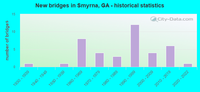
- New bridges - historical statistics
- 11930-1939
- 11950-1959
- 81960-1969
- 41970-1979
- 31980-1989
- 121990-1999
- 42000-2009
- 62010-2019
- 12020-2022

- Reconstructed bridges - Historical Statistics
- 61970-1979
- 21980-1989
- 11990-1999
- 02000-2009
- 12010-2019


- Bridge Condition - Deck
- 6.1%Very good
- 84.8%Good
- 9.1%Satisfactory

- Bridge Condition - Superstructure
- 30.3%Very good
- 69.7%Good

- Bridge Condition - Substructure
- 9.1%Very good
- 84.8%Good
- 3.0%Satisfactory
- 3.0%Fair

- Bridge Condition - Channel
- 5.3%Excellent
- 52.6%Very good
- 36.8%Good
- 5.3%Satisfactory
Find on map >> Show street view
Structure Number: 670011, Location: 5.6 MI SE OF MARIETTA (Lat: 33.894189, Lng: -84.479339), Route carried "on" structure: US 41, Year Built: 1936, Year Reconstructed: 1977, Status: Open, Structure Length: 0.70m (2.30ft), Average Daily Traffic: 42,070 (year 2012), Truck Traffic: 1%, Average Future Daily Traffic: 63,105 (year 2032), Design Load: HS 20, Features Intersected: POPLAR CREEK
Minimum Vertical Clearance: 30+ m (98+ ft), Kilometerpoint: 4.828, Lanes on structure: 6, Base Highway Network: Yes, Owner: State Highway Agency, Approaching Roadway Width: 24.1m (79.1ft), Skew: 9 degrees, Material/Design: Concrete, Design/Construction: Culvert, Number Of Spans In Main Unit: 2, Length of Maximum Span: 3.4m (11.2ft), Curb or Sidewalk Widths: Left: 1.2m (3.9ft), Right: 1.8m (5.9ft)
Condition: Channel: Satisfactory, Culverts: Good, Structural Evaluation: Better than present minimum criteria, Waterway Adequacy: Superior to present desirable criteria, Approach Roadway Alignment: Equal to present desirable criteria, Designated Inspection Frequency: Every 24 months, Inspection Date: March 2021
Find on map >> Show street view
Structure Number: 670052, Location: 4.5 MILES SOUTH EAST OF S (Lat: 33.825253, Lng: -84.489519), Route carried "on" structure: State highway 280, Year Built: 1969, Status: Open, Structure Length: 7.35m (24.11ft), Average Daily Traffic: 48,740 (year 2012), Truck Traffic: 1%, Average Future Daily Traffic: 73,110 (year 2032), Design Load: HS 20+Mod, Features Intersected: I-285, Facility Carried by Structure: SOUTH COBB DRIVE
Minimum Vertical Clearance: 30+ m (98+ ft), Kilometerpoint: 1.609, Lanes on structure: 7, Lanes under structure: 8, Base Highway Network: Yes, Owner: State Highway Agency, Approaching Roadway Width: 46.3m (151.9ft), Skew: 10 degrees, Material/Design: Steel, Design/Construction: Stringer/Multi-beam, Number Of Spans In Main Unit: 4, Length of Maximum Span: 21.3m (69.9ft), Curb or Sidewalk Widths: Left: 1.5m (4.9ft), Right: 1.5m (4.9ft), Curb-To-Curb Width: 28.1m (92.2ft), Out-to-Out Width: 31.5m (103.3ft)
Condition: Deck: Good, Superstructure: Good, Substructure: Good, Operating Rating: 43.5 metric tons, Method Used To Determine Operating Rating: Load Factor (LF), Inventory Rating: 26.3 metric tons, Method Used To Determine Inventory Rating: Load Factor (LF), Structural Evaluation: Equal to present minimum criteria, Deck Geometry: Somewhat better than minimum adequacy, Underclear: Meets minimum limits, Approach Roadway Alignment: Equal to present desirable criteria, Designated Inspection Frequency: Every 24 months, Inspection Date: September 2021, Bridge Improvement Cost: $2,226,000, Roadway Improvement Cost: $223,000, Total Project Cost: $3,339,000, Deck Structure Type: Concrete Cast-file-Place
Find on map >> Show street view
Structure Number: 670053, Location: 3.4 MI SE OF SMYRNA (Lat: 33.840017, Lng: -84.496181), Route carried "on" structure: State highway 280, Year Built: 1976, Status: Open, Structure Length: 5.49m (18.01ft), Average Daily Traffic: 30,520 (year 2012), Truck Traffic: 1%, Average Future Daily Traffic: 45,780 (year 2032), Design Load: HS 20+Mod, Features Intersected: CSX RAILROAD (639142K), Facility Carried by Structure: SOUTH COBB DRIVE
Minimum Vertical Clearance: 30+ m (98+ ft), Kilometerpoint: 3.219, Lanes on structure: 5, Base Highway Network: Yes, Owner: State Highway Agency, Approaching Roadway Width: 20.1m (65.9ft), Skew: 3 degrees, Material/Design: Steel, Design/Construction: Stringer/Multi-beam, Number Of Spans In Main Unit: 3, Length of Maximum Span: 20.1m (65.9ft), Curb-To-Curb Width: 20.1m (65.9ft), Out-to-Out Width: 20.8m (68.2ft)
Condition: Deck: Satisfactory, Superstructure: Good, Substructure: Good, Operating Rating: 39.9 metric tons, Method Used To Determine Operating Rating: Load Factor (LF), Inventory Rating: 23.5 metric tons, Method Used To Determine Inventory Rating: Load Factor (LF), Structural Evaluation: Somewhat better than minimum adequacy, Deck Geometry: Somewhat better than minimum adequacy, Underclear: Equal to present desirable criteria, Approach Roadway Alignment: Equal to present desirable criteria, Designated Inspection Frequency: Every 24 months, Inspection Date: March 2021, Deck Structure Type: Concrete Cast-file-Place
Find on map >> Show street view
Structure Number: 670054, Location: 1.9 MI SOUTH OF SMYRNA (Lat: 33.856008, Lng: -84.513850), Route carried "on" structure: State highway 280, Year Built: 1959, Year Reconstructed: 1976, Status: Open, Structure Length: 0.70m (2.30ft), Average Daily Traffic: 28,660 (year 2012), Truck Traffic: 3%, Average Future Daily Traffic: 42,990 (year 2032), Design Load: HS 20+Mod, Features Intersected: LAUREL BRANCH, Facility Carried by Structure: SOUTH COBB DRIVE
Minimum Vertical Clearance: 30+ m (98+ ft), Kilometerpoint: 4.828, Lanes on structure: 5, Base Highway Network: Yes, Owner: State Highway Agency, Approaching Roadway Width: 20.1m (65.9ft), Material/Design: Concrete, Design/Construction: Culvert, Number Of Spans In Main Unit: 3, Length of Maximum Span: 2.1m (6.9ft), Curb or Sidewalk Widths: Left: 1.5m (4.9ft), Right: 1.5m (4.9ft)
Condition: Channel: Very good, Culverts: Good, Structural Evaluation: Better than present minimum criteria, Waterway Adequacy: Superior to present desirable criteria, Approach Roadway Alignment: Equal to present desirable criteria, Designated Inspection Frequency: Every 24 months, Inspection Date: March 2021
Find on map >> Show street view
Structure Number: 670067, Location: 5.8 MI SE OF MARIETTA (Lat: 33.899119, Lng: -84.470639), Route carried "on" structure: Interstate 75, Year Built: 1963, Year Reconstructed: 1983, Status: Open, Structure Length: 0.88m (2.89ft), Average Daily Traffic: 257,440 (year 2012), Truck Traffic: 1%, Average Future Daily Traffic: 386,160 (year 2032), Design Load: HS 20+Mod, Features Intersected: POPLAR CREEK
Minimum Vertical Clearance: 30+ m (98+ ft), Kilometerpoint: 418.430, Lanes on structure: 13, Base Highway Network: Yes, Owner: State Highway Agency, Approaching Roadway Width: 58.8m (192.9ft), Skew: 39 degrees, Material/Design: Concrete, Design/Construction: Culvert, Number Of Spans In Main Unit: 2, Length of Maximum Span: 4.0m (13.1ft)
Condition: Channel: Very good, Culverts: Good, Structural Evaluation: Better than present minimum criteria, Waterway Adequacy: Superior to present desirable criteria, Approach Roadway Alignment: Equal to present desirable criteria, Designated Inspection Frequency: Every 24 months, Inspection Date: August 2021, Bridge Improvement Cost: $453,000, Roadway Improvement Cost: $45,000, Total Project Cost: $680,000
Find on map >> Show street view
Structure Number: 670091, Location: 4.7 MI SE OF SMYRNA (Lat: 33.818397, Lng: -84.495475), Route carried "on" structure: Interstate 285, Year Built: 1968, Year Reconstructed: 1983, Status: Open, Structure Length: 4.21m (13.81ft), Average Daily Traffic: 135,310 (year 2012), Truck Traffic: 1%, Average Future Daily Traffic: 202,965 (year 2032), Design Load: HS 20+Mod, Features Intersected: NS RR SPUR
Minimum Vertical Clearance: 30+ m (98+ ft), Kilometerpoint: 24.140, Lanes on structure: 8, Base Highway Network: Yes, Owner: State Highway Agency, Approaching Roadway Width: 39.0m (128.0ft), Skew: 32 degrees, Material/Design: Steel, Design/Construction: Stringer/Multi-beam, Number Of Spans In Main Unit: 1, Length of Maximum Span: 42.1m (138.1ft), Curb-To-Curb Width: 39.2m (128.6ft), Out-to-Out Width: 40.9m (134.2ft)
Condition: Deck: Satisfactory, Superstructure: Good, Substructure: Good, Operating Rating: 89.8 metric tons, Method Used To Determine Operating Rating: Load Factor (LF), Inventory Rating: 54.4 metric tons, Method Used To Determine Inventory Rating: Load Factor (LF), Structural Evaluation: Better than present minimum criteria, Deck Geometry: Superior to present desirable criteria, Underclear: Better than present minimum criteria, Approach Roadway Alignment: Equal to present desirable criteria, Designated Inspection Frequency: Every 24 months, Inspection Date: March 2021, Deck Structure Type: Concrete Cast-file-Place
Find on map >> Show street view
Structure Number: 670093, Location: 4.7 MI SE OF SMYRNA (Lat: 33.819172, Lng: -84.495000), Route carried "on" structure: Interstate 285, Year Built: 1968, Year Reconstructed: 1983, Status: Open, Structure Length: 4.75m (15.58ft), Average Daily Traffic: 135,310 (year 2012), Truck Traffic: 1%, Average Future Daily Traffic: 202,965 (year 2032), Design Load: HS 20+Mod, Features Intersected: NS RAILROAD
Minimum Vertical Clearance: 30+ m (98+ ft), Kilometerpoint: 24.140, Lanes on structure: 8, Base Highway Network: Yes, Owner: State Highway Agency, Approaching Roadway Width: 39.0m (128.0ft), Skew: 31 degrees, Material/Design: Steel, Design/Construction: Stringer/Multi-beam, Number Of Spans In Main Unit: 2, Length of Maximum Span: 30.5m (100.1ft), Curb-To-Curb Width: 39.1m (128.3ft), Out-to-Out Width: 40.9m (134.2ft)
Condition: Deck: Good, Superstructure: Good, Substructure: Good, Operating Rating: 28.1 metric tons, Method Used To Determine Operating Rating: Load Factor (LF), Inventory Rating: 16.3 metric tons, Method Used To Determine Inventory Rating: Load Factor (LF), Structural Evaluation: Meets minimum limits, Deck Geometry: Superior to present desirable criteria, Underclear: Equal to present minimum criteria, Approach Roadway Alignment: Equal to present desirable criteria, Designated Inspection Frequency: Every 24 months, Inspection Date: March 2021, Deck Structure Type: Concrete Cast-file-Place
Find on map >> Show street view
Structure Number: 670095, Location: 4.3 MI SE OF SMYRNA (Lat: 33.829850, Lng: -84.486336), Route carried "on" structure: Interstate 285, Year Built: 1969, Year Reconstructed: 1983, Status: Open, Structure Length: 6.83m (22.41ft), Average Daily Traffic: 140,510 (year 2012), Truck Traffic: 1%, Average Future Daily Traffic: 210,765 (year 2032), Design Load: HS 20+Mod, Features Intersected: M-9325 CHURCH ROAD
Minimum Vertical Clearance: 30+ m (98+ ft), Kilometerpoint: 25.750, Lanes on structure: 8, Lanes under structure: 2, Base Highway Network: Yes, Owner: State Highway Agency, Approaching Roadway Width: 39.0m (128.0ft), Skew: 34 degrees, Material/Design: Steel, Design/Construction: Stringer/Multi-beam, Number Of Spans In Main Unit: 3, Length of Maximum Span: 24.4m (80.1ft), Curb-To-Curb Width: 39.2m (128.6ft), Out-to-Out Width: 40.9m (134.2ft)
Condition: Deck: Good, Superstructure: Good, Substructure: Good, Operating Rating: 38.1 metric tons, Method Used To Determine Operating Rating: Load Factor (LF), Inventory Rating: 22.6 metric tons, Method Used To Determine Inventory Rating: Load Factor (LF), Structural Evaluation: Somewhat better than minimum adequacy, Deck Geometry: Superior to present desirable criteria, Underclear: Equal to present minimum criteria, Approach Roadway Alignment: Equal to present desirable criteria, Designated Inspection Frequency: Every 24 months, Inspection Date: March 2021, Deck Structure Type: Concrete Cast-file-Place
Find on map >> Show street view
Structure Number: 670099, Location: 3.1 MI EAST OF SMYRNA (Lat: 33.884403, Lng: -84.469936), Route carried "on" structure: Interstate 285, Year Built: 1963, Year Reconstructed: 1986, Status: Open, Structure Length: 7.32m (24.02ft), Average Daily Traffic: 147,990 (year 2012), Truck Traffic: 1%, Average Future Daily Traffic: 221,985 (year 2032), Design Load: HS 20+Mod, Features Intersected: SR 3 (US 41)
Minimum Vertical Clearance: 30+ m (98+ ft), Kilometerpoint: 32.187, Lanes on structure: 8, Lanes under structure: 10, Base Highway Network: Yes, Owner: State Highway Agency, Approaching Roadway Width: 40.2m (131.9ft), Skew: 32 degrees, Material/Design: Steel, Design/Construction: Stringer/Multi-beam, Number Of Spans In Main Unit: 4, Length of Maximum Span: 24.7m (81.0ft), Curb-To-Curb Width: 43.4m (142.4ft), Out-to-Out Width: 45.5m (149.3ft)
Condition: Deck: Good, Superstructure: Good, Substructure: Good, Operating Rating: 31.7 metric tons, Method Used To Determine Operating Rating: Load Factor (LF), Inventory Rating: 19.0 metric tons, Method Used To Determine Inventory Rating: Load Factor (LF), Structural Evaluation: Meets minimum limits, Deck Geometry: Superior to present desirable criteria, Underclear: Meets minimum limits, Approach Roadway Alignment: Equal to present desirable criteria, Designated Inspection Frequency: Every 24 months, Inspection Date: June 2021, Bridge Improvement Cost: $2,472,000, Roadway Improvement Cost: $247,000, Total Project Cost: $3,708,000, Deck Structure Type: Concrete Cast-file-Place
Find on map >> Show street view
Structure Number: 6701, Location: 6.7 MI SE OF MARIETTA (Lat: 33.889228, Lng: -84.462689), Route carried "on" structure: Interstate 285, Year Built: 1978, Year Reconstructed: 2015, Status: Open, Structure Length: 6.46m (21.19ft), Average Daily Traffic: 79,670 (year 2012), Truck Traffic: 5%, Average Future Daily Traffic: 119,505 (year 2032), Design Load: HS 20+Mod, Features Intersected: RMP I-285 CCBL TO I-75S
Minimum Vertical Clearance: 30+ m (98+ ft), Kilometerpoint: 32.187, Lanes on structure: 5, Lanes under structure: 2, Base Highway Network: Yes, Owner: State Highway Agency, Approaching Roadway Width: 32.6m (107.0ft), Skew: 33 degrees, Material/Design: Steel continuous, Design/Construction: Stringer/Multi-beam, Number Of Spans In Main Unit: 3, Number Of Approach Spans: 2, Length of Maximum Span: 37.5m (123.0ft), Curb-To-Curb Width: 32.8m (107.6ft), Out-to-Out Width: 37.1m (121.7ft)
Condition: Deck: Good, Superstructure: Good, Substructure: Good, Operating Rating: 53.5 metric tons, Method Used To Determine Operating Rating: Load Factor (LF), Inventory Rating: 31.7 metric tons, Method Used To Determine Inventory Rating: Load Factor (LF), Structural Evaluation: Better than present minimum criteria, Deck Geometry: Superior to present desirable criteria, Underclear: Better than present minimum criteria, Approach Roadway Alignment: Equal to present desirable criteria, Designated Inspection Frequency: Every 24 months, Inspection Date: June 2021, Bridge Improvement Cost: $1,506,000, Roadway Improvement Cost: $151,000, Total Project Cost: $2,259,000, Deck Structure Type: Concrete Cast-file-Place, Wearing Surface/Protective System: Wearing Surface: Epoxy Overlay
Find on map >> Show street view
Structure Number: 670101, Location: 6.7 MI SE OF MARIETTA (Lat: 33.890269, Lng: -84.460769), Route carried "on" structure: Interstate 285, Year Built: 1978, Status: Open, Structure Length: 9.81m (32.19ft), Average Daily Traffic: 79,670 (year 2012), Truck Traffic: 1%, Average Future Daily Traffic: 119,505 (year 2032), Design Load: HS 20+Mod, Features Intersected: I-75
Minimum Vertical Clearance: 30+ m (98+ ft), Kilometerpoint: 32.187, Lanes on structure: 5, Lanes under structure: 10, Base Highway Network: Yes, Owner: State Highway Agency, Approaching Roadway Width: 32.9m (107.9ft), Skew: 30 degrees, Material/Design: Steel continuous, Design/Construction: Stringer/Multi-beam, Number Of Spans In Main Unit: 4, Length of Maximum Span: 28.3m (92.8ft), Curb-To-Curb Width: 32.8m (107.6ft), Out-to-Out Width: 34.7m (113.8ft)
Condition: Deck: Good, Superstructure: Good, Substructure: Good, Operating Rating: 43.5 metric tons, Method Used To Determine Operating Rating: Load Factor (LF), Inventory Rating: 25.4 metric tons, Method Used To Determine Inventory Rating: Load Factor (LF), Structural Evaluation: Equal to present minimum criteria, Deck Geometry: Superior to present desirable criteria, Underclear: Meets minimum limits, Approach Roadway Alignment: Equal to present desirable criteria, Designated Inspection Frequency: Every 24 months, Inspection Date: April 2021, Bridge Improvement Cost: $2,287,000, Roadway Improvement Cost: $229,000, Total Project Cost: $3,431,000, Deck Structure Type: Concrete Cast-file-Place
Find on map >> Show street view
Structure Number: 670104, Location: 6.7 MI SE OF MARIETTA (Lat: 33.892047, Lng: -84.459261), Route carried "on" structure: Ramp Interstate 285, Year Built: 1963, Year Reconstructed: 1985, Status: Open, Structure Length: 3.29m (10.79ft), Average Daily Traffic: 1,600 (year 2012), Truck Traffic: 1%, Average Future Daily Traffic: 2,400 (year 2032), Design Load: HS 20+Mod, Features Intersected: I-285 RAMP TO I-75 NBL
Minimum Vertical Clearance: 30+ m (98+ ft), Kilometerpoint: 32.187, Lanes on structure: 2, Lanes under structure: 2, Base Highway Network: Yes, Owner: State Highway Agency, Approaching Roadway Width: 11.6m (38.1ft), Skew: 2 degrees, Material/Design: Steel, Design/Construction: Stringer/Multi-beam, Number Of Spans In Main Unit: 3, Length of Maximum Span: 12.8m (42.0ft), Curb-To-Curb Width: 12.8m (42.0ft), Out-to-Out Width: 13.8m (45.3ft)
Condition: Deck: Good, Superstructure: Good, Substructure: Good, Operating Rating: 33.5 metric tons, Method Used To Determine Operating Rating: Load Factor (LF), Inventory Rating: 19.9 metric tons, Method Used To Determine Inventory Rating: Load Factor (LF), Structural Evaluation: Somewhat better than minimum adequacy, Deck Geometry: Superior to present desirable criteria, Underclear: Meets minimum limits, Approach Roadway Alignment: Equal to present desirable criteria, Designated Inspection Frequency: Every 24 months, Inspection Date: March 2021, Deck Structure Type: Concrete Cast-file-Place
Find on map >> Show street view
Structure Number: 670129, Location: 3.2 MI E OF SMYRNA (Lat: 33.880089, Lng: -84.473189), Route carried "on" structure: City street 9016, Year Built: 1969, Status: Open, Structure Length: 9.75m (31.99ft), Average Daily Traffic: 15,090 (year 2012), Truck Traffic: 1%, Average Future Daily Traffic: 22,635 (year 2032), Design Load: HS 20+Mod, Features Intersected: I-285-CR1951 SPRING HILL, Facility Carried by Structure: CUMBERLAND BLVD.
Minimum Vertical Clearance: 30+ m (98+ ft), Kilometerpoint: 0.000, Lanes on structure: 4, Lanes under structure: 10, Base Highway Network: Yes, Owner: State Highway Agency, Approaching Roadway Width: 15.8m (51.8ft), Skew: 2 degrees, Material/Design: Steel, Design/Construction: Stringer/Multi-beam, Number Of Spans In Main Unit: 5, Length of Maximum Span: 23.2m (76.1ft), Curb or Sidewalk Widths: Left: 0.7m (2.3ft), Right: 0.7m (2.3ft), Curb-To-Curb Width: 15.9m (52.2ft), Out-to-Out Width: 17.7m (58.1ft)
Condition: Deck: Good, Superstructure: Good, Substructure: Good, Operating Rating: 36.2 metric tons, Method Used To Determine Operating Rating: Load Factor (LF), Inventory Rating: 21.7 metric tons, Method Used To Determine Inventory Rating: Load Factor (LF), Structural Evaluation: Somewhat better than minimum adequacy, Deck Geometry: Meets minimum limits, Underclear: Meets minimum limits, Approach Roadway Alignment: Equal to present desirable criteria, Designated Inspection Frequency: Every 24 months, Inspection Date: August 2021, Bridge Improvement Cost: $1,932,000, Roadway Improvement Cost: $193,000, Total Project Cost: $2,898,000, Deck Structure Type: Concrete Cast-file-Place, Wearing Surface/Protective System: Wearing Surface: Epoxy Overlay
Find on map >> Show street view
Structure Number: 670155, Location: 4.4 MI S OF SMYRNA (Lat: 33.819889, Lng: -84.498828), Route carried "on" structure: City street 9025, Year Built: 1993, Status: Open, Structure Length: 3.05m (10.01ft), Average Daily Traffic: 18,170 (year 2012), Truck Traffic: 1%, Average Future Daily Traffic: 27,255 (year 2032), Design Load: HS 20+Mod, Features Intersected: N S RAIL ROAD (719840A), Facility Carried by Structure: OAKDALE ROAD
Minimum Vertical Clearance: 30+ m (98+ ft), Kilometerpoint: 11.265, Lanes on structure: 2, Base Highway Network: Yes, Owner: County Highway Agency, Approaching Roadway Width: 12.2m (40.0ft), Material/Design: Steel, Design/Construction: Stringer/Multi-beam, Number Of Spans In Main Unit: 3, Length of Maximum Span: 22.6m (74.1ft), Curb-To-Curb Width: 11.8m (38.7ft), Out-to-Out Width: 12.8m (42.0ft)
Condition: Deck: Good, Superstructure: Good, Substructure: Good, Operating Rating: 67.1 metric tons, Method Used To Determine Operating Rating: Load Factor (LF), Inventory Rating: 39.9 metric tons, Method Used To Determine Inventory Rating: Load Factor (LF), Structural Evaluation: Better than present minimum criteria, Deck Geometry: Somewhat better than minimum adequacy, Underclear: Somewhat better than minimum adequacy, Approach Roadway Alignment: Equal to present desirable criteria, Designated Inspection Frequency: Every 24 months, Inspection Date: April 2021, Bridge Improvement Cost: $391,000, Roadway Improvement Cost: $39,000, Total Project Cost: $586,000, Deck Structure Type: Concrete Cast-file-Place
Find on map >> Show street view
Structure Number: 670166, Location: 1.8 MI W OF SMYRNA (Lat: 33.869878, Lng: -84.555708), Route carried "on" structure: City street 9036, Year Built: 1996, Status: Open, Structure Length: 3.66m (12.01ft), Average Daily Traffic: 8,830 (year 2012), Truck Traffic: 1%, Average Future Daily Traffic: 13,245 (year 2032), Design Load: HS 20+Mod, Features Intersected: NICKAJACK CREEK, Facility Carried by Structure: HURT ROAD
Minimum Vertical Clearance: 30+ m (98+ ft), Kilometerpoint: 8.047, Lanes on structure: 2, Base Highway Network: Yes, Owner: County Highway Agency, Approaching Roadway Width: 7.3m (24.0ft), Material/Design: Prestressed concrete, Design/Construction: Box Beam or Girders - Multiple, Number Of Spans In Main Unit: 3, Length of Maximum Span: 14.0m (45.9ft), Curb or Sidewalk Widths: Left: 1.4m (4.6ft), Right: 1.4m (4.6ft), Curb-To-Curb Width: 8.6m (28.2ft), Out-to-Out Width: 12.2m (40.0ft)
Condition: Deck: Good, Superstructure: Good, Substructure: Good, Channel: Very good, Operating Rating: 33.5 metric tons, Method Used To Determine Operating Rating: Load Factor (LF), Inventory Rating: 18.1 metric tons, Method Used To Determine Inventory Rating: Load Factor (LF), Structural Evaluation: Meets minimum limits, Deck Geometry: High priority of replacement, Waterway Adequacy: Superior to present desirable criteria, Approach Roadway Alignment: Equal to present desirable criteria, Designated Inspection Frequency: Every 24 months, Inspection Date: April 2021, Bridge Improvement Cost: $469,000, Roadway Improvement Cost: $47,000, Total Project Cost: $703,000, Deck Structure Type: Concrete Precast Panels, Wearing Surface/Protective System: Wearing Surface: Bituminous
Find on map >> Show street view
Structure Number: 670195, Location: 0.87 NW I-75 & I-285 INT (Lat: 33.896178, Lng: -84.467439), Route carried "on" structure: Ramp Interstate 75, Year Built: 1985, Status: Open, Structure Length: 7.86m (25.79ft), Average Daily Traffic: 16,600 (year 2012), Truck Traffic: 1%, Average Future Daily Traffic: 24,900 (year 2032), Design Load: HS 20+Mod, Features Intersected: I-75 RAMP TO I-285
Minimum Vertical Clearance: 30+ m (98+ ft), Kilometerpoint: 416.820, Lanes on structure: 1, Lanes under structure: 3, Base Highway Network: Yes, Owner: State Highway Agency, Approaching Roadway Width: 8.8m (28.9ft), Material/Design: Prestressed concrete, Design/Construction: Box Beam or Girders - Single/Spread, Number Of Spans In Main Unit: 1, Length of Maximum Span: 78.6m (257.9ft), Curb-To-Curb Width: 9.1m (29.9ft), Out-to-Out Width: 10.1m (33.1ft)
Condition: Deck: Good, Superstructure: Good, Substructure: Good, Operating Rating: 55.3 metric tons, Method Used To Determine Operating Rating: Load Factor (LF), Inventory Rating: 32.6 metric tons, Method Used To Determine Inventory Rating: Load Factor (LF), Structural Evaluation: Better than present minimum criteria, Deck Geometry: Superior to present desirable criteria, Underclear: Superior to present desirable criteria, Approach Roadway Alignment: Equal to present desirable criteria, Designated Inspection Frequency: Every 24 months, Inspection Date: September 2021, Bridge Improvement Cost: $733,000, Roadway Improvement Cost: $73,000, Total Project Cost: $1,100,000, Deck Structure Type: Concrete Cast-file-Place
Find on map >> Show street view
Structure Number: 670197, Location: I-285 & I-75 INTERCHANGE (Lat: 33.890061, Lng: -84.462917), Route carried "on" structure: Ramp Interstate 75, Year Built: 1986, Year Reconstructed: 1990, Status: Open, Structure Length: 4.72m (15.49ft), Average Daily Traffic: 27,350 (year 2012), Truck Traffic: 1%, Average Future Daily Traffic: 41,025 (year 2032), Design Load: HS 20+Mod, Features Intersected: I-285 CD WEST BOUND
Minimum Vertical Clearance: 5.28m (17.32ft), Kilometerpoint: 416.820, Lanes on structure: 2, Lanes under structure: 2, Base Highway Network: Yes, Owner: State Highway Agency, Approaching Roadway Width: 12.2m (40.0ft), Skew: 9 degrees, Material/Design: Steel, Design/Construction: Stringer/Multi-beam, Number Of Spans In Main Unit: 1, Length of Maximum Span: 47.2m (154.9ft), Curb-To-Curb Width: 15.2m (49.9ft), Out-to-Out Width: 16.2m (53.1ft)
Condition: Deck: Good, Superstructure: Good, Substructure: Good, Operating Rating: 55.3 metric tons, Method Used To Determine Operating Rating: Load Factor (LF), Inventory Rating: 32.6 metric tons, Method Used To Determine Inventory Rating: Load Factor (LF), Structural Evaluation: Better than present minimum criteria, Deck Geometry: Superior to present desirable criteria, Underclear: Superior to present desirable criteria, Approach Roadway Alignment: Equal to present desirable criteria, Designated Inspection Frequency: Every 24 months, Inspection Date: June 2021, Bridge Improvement Cost: $606,000, Roadway Improvement Cost: $61,000, Total Project Cost: $908,000, Deck Structure Type: Concrete Cast-file-Place
Find on map >> Show street view
Structure Number: 670203, Location: 4 MI S OF SMYRNA (Lat: 33.828297, Lng: -84.501628), Route carried "on" structure: County highway 2835, Year Built: 1983, Status: Open, Structure Length: 1.01m (3.31ft), Average Daily Traffic: 28,820 (year 2012), Truck Traffic: 1%, Average Future Daily Traffic: 43,230 (year 2032), Design Load: HS 20+Mod, Features Intersected: NICKAJACK CREEK TRIB., Facility Carried by Structure: HIGHLAND PARKWAY
Minimum Vertical Clearance: 30+ m (98+ ft), Kilometerpoint: 12.875, Lanes on structure: 4, Base Highway Network: Yes, Owner: County Highway Agency, Approaching Roadway Width: 17.1m (56.1ft), Skew: 13 degrees, Material/Design: Concrete, Design/Construction: Culvert, Number Of Spans In Main Unit: 3, Length of Maximum Span: 3.0m (9.8ft), Curb or Sidewalk Widths: Left: 1.5m (4.9ft), Right: 1.5m (4.9ft)
Condition: Channel: Very good, Culverts: Good, Operating Rating: 55.3 metric tons, Method Used To Determine Operating Rating: Field evaluation and documented engineering judgment, Inventory Rating: 32.6 metric tons, Method Used To Determine Inventory Rating: Field evaluation and documented engineering judgment, Structural Evaluation: Better than present minimum criteria, Waterway Adequacy: Superior to present desirable criteria, Approach Roadway Alignment: Equal to present desirable criteria, Designated Inspection Frequency: Every 24 months, Inspection Date: April 2021, Bridge Improvement Cost: $199,000, Roadway Improvement Cost: $20,000, Total Project Cost: $299,000
Find on map >> Show street view
Structure Number: 675129, Location: 6 MI SE OF MARIETTA (Lat: 33.901069, Lng: -84.466319), Route carried "on" structure: County highway 3068, Year Built: 1975, Status: Open, Structure Length: 5.49m (18.01ft), Average Daily Traffic: 8,980 (year 2012), Truck Traffic: 1%, Average Future Daily Traffic: 13,470 (year 2032), Design Load: HS 20+Mod, Features Intersected: ROTTENWOOD CREEK, Facility Carried by Structure: INTERST NORTH PWY
Minimum Vertical Clearance: 30+ m (98+ ft), Kilometerpoint: 3.219, Lanes on structure: 4, Base Highway Network: Yes, Owner: County Highway Agency, Approaching Roadway Width: 15.8m (51.8ft), Material/Design: Steel, Design/Construction: Stringer/Multi-beam, Number Of Spans In Main Unit: 4, Length of Maximum Span: 18.3m (60.0ft), Curb or Sidewalk Widths: Left: 0.6m (2.0ft), Right: 1.2m (3.9ft), Curb-To-Curb Width: 15.2m (49.9ft), Out-to-Out Width: 17.7m (58.1ft)
Condition: Deck: Satisfactory, Superstructure: Good, Substructure: Satisfactory, Channel: Good, Operating Rating: 46.2 metric tons, Method Used To Determine Operating Rating: Allowable Stress (AS), Inventory Rating: 32.6 metric tons, Method Used To Determine Inventory Rating: Allowable Stress (AS), Structural Evaluation: Equal to present minimum criteria, Deck Geometry: High priority of corrective action, Waterway Adequacy: Superior to present desirable criteria, Approach Roadway Alignment: Equal to present desirable criteria, Designated Inspection Frequency: Every 24 months, Inspection Date: March 2021, Deck Structure Type: Concrete Cast-file-Place
Find on map >> Show street view
Structure Number: 675179, Location: 3 MI SW OF SYRMNA (Lat: 33.854078, Lng: -84.559728), Route carried "on" structure: City street 2835, Year Built: 1997, Status: Open, Structure Length: 28.65m (94.00ft), Average Daily Traffic: 28,820 (year 2012), Truck Traffic: 1%, Average Future Daily Traffic: 43,230 (year 2032), Design Load: HS 20+Mod, Features Intersected: NICKAJACK CREEK, Facility Carried by Structure: EAST-WEST CONN
Minimum Vertical Clearance: 30+ m (98+ ft), Kilometerpoint: 6.437, Lanes on structure: 4, Base Highway Network: Yes, Owner: County Highway Agency, Approaching Roadway Width: 17.1m (56.1ft), Skew: 20 degrees, Material/Design: Prestressed concrete, Design/Construction: Stringer/Multi-beam, Number Of Spans In Main Unit: 8, Length of Maximum Span: 38.1m (125.0ft), Curb-To-Curb Width: 24.4m (80.1ft), Out-to-Out Width: 25.1m (82.3ft)
Condition: Deck: Good, Superstructure: Good, Substructure: Good, Channel: Very good, Operating Rating: 88.9 metric tons, Method Used To Determine Operating Rating: Load Factor (LF), Inventory Rating: 31.7 metric tons, Method Used To Determine Inventory Rating: Load Factor (LF), Structural Evaluation: Better than present minimum criteria, Deck Geometry: Superior to present desirable criteria, Waterway Adequacy: Superior to present desirable criteria, Approach Roadway Alignment: Equal to present desirable criteria, Designated Inspection Frequency: Every 24 months, Inspection Date: October 2021, Bridge Improvement Cost: $5,676,000, Roadway Improvement Cost: $568,000, Total Project Cost: $8,514,000, Deck Structure Type: Concrete Cast-file-Place
Find on map >> Show street view
Structure Number: 67518, Location: 3 MILES SOUTH WEST OF SMY (Lat: 33.852869, Lng: -84.557481), Route carried "on" structure: County highway 1782, Year Built: 1997, Status: Open, Structure Length: 3.93m (12.89ft), Average Daily Traffic: 5,170 (year 2012), Truck Traffic: 1%, Average Future Daily Traffic: 7,755 (year 2032), Design Load: HS 20, Features Intersected: M-9034 E-W CONNECTOR, Facility Carried by Structure: CONCORD ROAD
Minimum Vertical Clearance: 30+ m (98+ ft), Kilometerpoint: 11.265, Lanes on structure: 2, Lanes under structure: 4, Base Highway Network: Yes, Owner: County Highway Agency, Approaching Roadway Width: 6.4m (21.0ft), Skew: 2 degrees, Material/Design: Prestressed concrete, Design/Construction: Stringer/Multi-beam, Number Of Spans In Main Unit: 1, Length of Maximum Span: 39.3m (128.9ft), Curb-To-Curb Width: 11.5m (37.7ft), Out-to-Out Width: 12.4m (40.7ft)
Condition: Deck: Good, Superstructure: Good, Substructure: Good, Operating Rating: 46.2 metric tons, Method Used To Determine Operating Rating: Allowable Stress (AS), Inventory Rating: 32.6 metric tons, Method Used To Determine Inventory Rating: Allowable Stress (AS), Structural Evaluation: Better than present minimum criteria, Deck Geometry: Meets minimum limits, Underclear: Equal to present minimum criteria, Approach Roadway Alignment: Equal to present desirable criteria, Designated Inspection Frequency: Every 24 months, Inspection Date: August 2021, Bridge Improvement Cost: $504,000, Roadway Improvement Cost: $50,000, Total Project Cost: $756,000, Deck Structure Type: Concrete Cast-file-Place
Find on map >> Show street view
Structure Number: 675181, Location: 3 MILES SOUTH OF SMYRNA (Lat: 33.845669, Lng: -84.534008), Route carried "on" structure: City street 2835, Year Built: 1997, Status: Open, Structure Length: 0.64m (2.10ft), Average Daily Traffic: 28,820 (year 2012), Truck Traffic: 1%, Average Future Daily Traffic: 43,230 (year 2032), Design Load: HS 20+Mod, Features Intersected: COOPER LAKE TRIB., Facility Carried by Structure: EAST/WEST CONNECTO
Minimum Vertical Clearance: 30+ m (98+ ft), Kilometerpoint: 9.656, Lanes on structure: 4, Base Highway Network: Yes, Owner: County Highway Agency, Approaching Roadway Width: 17.1m (56.1ft), Skew: 10 degrees, Material/Design: Concrete, Design/Construction: Culvert, Number Of Spans In Main Unit: 2, Length of Maximum Span: 3.0m (9.8ft)
Condition: Channel: Good, Culverts: Good, Structural Evaluation: Better than present minimum criteria, Waterway Adequacy: Equal to present desirable criteria, Approach Roadway Alignment: Equal to present desirable criteria, Designated Inspection Frequency: Every 24 months, Inspection Date: August 2021, Bridge Improvement Cost: $127,000, Roadway Improvement Cost: $13,000, Total Project Cost: $190,000
Find on map >> Show street view
Structure Number: 675191, Location: 3 MI. EAST OF SMYRNA (Lat: 33.894367, Lng: -84.464489), Route carried "on" structure: County highway 9036, Year Built: 1998, Status: Open, Structure Length: 16.79m (55.09ft), Average Daily Traffic: 6,420 (year 2012), Truck Traffic: 1%, Average Future Daily Traffic: 9,630 (year 2032), Design Load: HS 20+Mod, Features Intersected: I-75 AND RAMPS, Facility Carried by Structure: WINDY RIDGE PARKWA
Minimum Vertical Clearance: 30+ m (98+ ft), Kilometerpoint: 17.703, Lanes on structure: 5, Lanes under structure: 20, Base Highway Network: Yes, Owner: State Highway Agency, Approaching Roadway Width: 17.1m (56.1ft), Skew: 20 degrees, Material/Design: Steel continuous, Design/Construction: Stringer/Multi-beam, Number Of Spans In Main Unit: 5, Length of Maximum Span: 61.0m (200.1ft), Curb or Sidewalk Widths: Left: 1.8m (5.9ft), Right: 1.8m (5.9ft), Curb-To-Curb Width: 21.9m (71.9ft), Out-to-Out Width: 38.7m (127.0ft)
Condition: Deck: Good, Superstructure: Good, Substructure: Good, Operating Rating: 48.0 metric tons, Method Used To Determine Operating Rating: Allowable Stress (AS), Inventory Rating: 32.6 metric tons, Method Used To Determine Inventory Rating: Allowable Stress (AS), Structural Evaluation: Better than present minimum criteria, Deck Geometry: Somewhat better than minimum adequacy, Underclear: Meets minimum limits, Approach Roadway Alignment: Equal to present desirable criteria, Designated Inspection Frequency: Every 24 months, Inspection Date: September 2021, Bridge Improvement Cost: $3,914,000, Roadway Improvement Cost: $391,000, Total Project Cost: $5,871,000, Deck Structure Type: Concrete Cast-file-Place
Find on map >> Show street view
Structure Number: 675192, Location: 3.3 MI E OF SMYRNA (Lat: 33.897628, Lng: -84.460036), Route carried "on" structure: City street 2039, Year Built: 1998, Status: Open, Structure Length: 4.75m (15.58ft), Average Daily Traffic: 6,420 (year 2012), Truck Traffic: 1%, Average Future Daily Traffic: 9,630 (year 2032), Design Load: HS 20+Mod, Features Intersected: ROTTENWOOD CREEK, Facility Carried by Structure: WINDY RIDGE PWY
Minimum Vertical Clearance: 30+ m (98+ ft), Kilometerpoint: 17.703, Lanes on structure: 4, Base Highway Network: Yes, Owner: City or Municipal Highway Agency, Approaching Roadway Width: 17.1m (56.1ft), Skew: 20 degrees, Material/Design: Prestressed concrete, Design/Construction: Stringer/Multi-beam, Number Of Spans In Main Unit: 2, Length of Maximum Span: 23.8m (78.1ft), Curb or Sidewalk Widths: Left: 1.8m (5.9ft), Right: 1.8m (5.9ft), Curb-To-Curb Width: 21.9m (71.9ft), Out-to-Out Width: 26.3m (86.3ft)
Condition: Deck: Good, Superstructure: Good, Substructure: Good, Channel: Very good, Operating Rating: 58.9 metric tons, Method Used To Determine Operating Rating: Allowable Stress (AS), Inventory Rating: 33.5 metric tons, Method Used To Determine Inventory Rating: Allowable Stress (AS), Structural Evaluation: Better than present minimum criteria, Deck Geometry: Superior to present desirable criteria, Waterway Adequacy: Equal to present desirable criteria, Approach Roadway Alignment: Equal to present desirable criteria, Designated Inspection Frequency: Every 24 months, Inspection Date: September 2021, Bridge Improvement Cost: $942,000, Roadway Improvement Cost: $94,000, Total Project Cost: $1,413,000, Deck Structure Type: Concrete Cast-file-Place
Find on map >> Show street view
Structure Number: 675199, Location: 2.5 MILES SOUTH OF SMYRNA (Lat: 33.845128, Lng: -84.512200), Route carried "on" structure: County highway 9003, Year Built: 1999, Status: Open, Structure Length: 1.01m (3.31ft), Average Daily Traffic: 5,600 (year 2012), Truck Traffic: 1%, Average Future Daily Traffic: 8,400 (year 2032), Design Load: HS 20, Features Intersected: LAUREL BRANCH, Facility Carried by Structure: COOPER LAKE ROAD
Minimum Vertical Clearance: 30+ m (98+ ft), Kilometerpoint: 6.437, Lanes on structure: 2, Base Highway Network: Yes, Owner: County Highway Agency, Approaching Roadway Width: 6.7m (22.0ft), Material/Design: Concrete, Design/Construction: Culvert, Number Of Spans In Main Unit: 3, Length of Maximum Span: 3.0m (9.8ft)
Condition: Channel: Very good, Culverts: Good, Operating Rating: 55.3 metric tons, Method Used To Determine Operating Rating: Field evaluation and documented engineering judgment, Inventory Rating: 32.6 metric tons, Method Used To Determine Inventory Rating: Field evaluation and documented engineering judgment, Structural Evaluation: Better than present minimum criteria, Waterway Adequacy: Equal to present desirable criteria, Approach Roadway Alignment: Better than present minimum criteria, Designated Inspection Frequency: Every 24 months, Inspection Date: August 2021, Bridge Improvement Cost: $129,000, Roadway Improvement Cost: $13,000, Total Project Cost: $193,000
Find on map >> Show street view
Structure Number: 675209, Location: 2.6 MILES SOUTH OF SMYRNA (Lat: 33.842806, Lng: -84.533342), Route carried "on" structure: City street 9003, Year Built: 1999, Status: Open, Structure Length: 8.38m (27.49ft), Average Daily Traffic: 9,900 (year 2012), Truck Traffic: 1%, Average Future Daily Traffic: 14,850 (year 2032), Design Load: HS 20+Mod, Features Intersected: NICKAJACK CREEK, Facility Carried by Structure: COPPER LAKE ROAD
Minimum Vertical Clearance: 30+ m (98+ ft), Kilometerpoint: 8.047, Lanes on structure: 2, Base Highway Network: Yes, Owner: County Highway Agency, Approaching Roadway Width: 7.3m (24.0ft), Skew: 3 degrees, Material/Design: Prestressed concrete, Design/Construction: Stringer/Multi-beam, Number Of Spans In Main Unit: 5, Length of Maximum Span: 16.8m (55.1ft), Curb-To-Curb Width: 12.1m (39.7ft), Out-to-Out Width: 13.1m (43.0ft)
Condition: Deck: Good, Superstructure: Good, Substructure: Good, Channel: Very good, Operating Rating: 49.8 metric tons, Method Used To Determine Operating Rating: Load Factor (LF), Inventory Rating: 29.9 metric tons, Method Used To Determine Inventory Rating: Load Factor (LF), Structural Evaluation: Better than present minimum criteria, Deck Geometry: Somewhat better than minimum adequacy, Waterway Adequacy: Equal to present desirable criteria, Approach Roadway Alignment: Equal to present desirable criteria, Designated Inspection Frequency: Every 24 months, Inspection Date: August 2021, Bridge Improvement Cost: $1,074,000, Roadway Improvement Cost: $107,000, Total Project Cost: $1,612,000, Deck Structure Type: Concrete Cast-file-Place
Find on map >> Show street view
Structure Number: 67521, Location: 2.8 MI S OF SMYRNA (Lat: 33.839889, Lng: -84.535586), Route carried "on" structure: City street 9003, Year Built: 1999, Status: Open, Structure Length: 5.36m (17.59ft), Average Daily Traffic: 5,790 (year 2012), Truck Traffic: 1%, Average Future Daily Traffic: 8,685 (year 2032), Design Load: HS 20+Mod, Features Intersected: NOR SOUTHERN RAILROAD, Facility Carried by Structure: COOPER LAKE ROAD
Minimum Vertical Clearance: 30+ m (98+ ft), Kilometerpoint: 9.656, Lanes on structure: 2, Base Highway Network: Yes, Owner: County Highway Agency, Approaching Roadway Width: 7.3m (24.0ft), Material/Design: Prestressed concrete, Design/Construction: Stringer/Multi-beam, Number Of Spans In Main Unit: 2, Length of Maximum Span: 35.4m (116.1ft), Curb-To-Curb Width: 12.2m (40.0ft), Out-to-Out Width: 13.2m (43.3ft)
Condition: Deck: Good, Superstructure: Very good, Substructure: Good, Operating Rating: 63.5 metric tons, Method Used To Determine Operating Rating: Load Factor (LF), Inventory Rating: 37.1 metric tons, Method Used To Determine Inventory Rating: Load Factor (LF), Structural Evaluation: Better than present minimum criteria, Deck Geometry: Somewhat better than minimum adequacy, Underclear: Somewhat better than minimum adequacy, Approach Roadway Alignment: Equal to present desirable criteria, Designated Inspection Frequency: Every 24 months, Inspection Date: August 2021, Bridge Improvement Cost: $688,000, Roadway Improvement Cost: $69,000, Total Project Cost: $1,032,000, Deck Structure Type: Concrete Cast-file-Place
Find on map >> Show street view
Structure Number: 675218, Location: 1 MI W OF SMYRNA (Lat: 33.876608, Lng: -84.542850), Route carried "on" structure: County highway 1874, Year Built: 1999, Status: Open, Structure Length: 2.99m (9.81ft), Average Daily Traffic: 1,930 (year 2012), Truck Traffic: 1%, Average Future Daily Traffic: 2,895 (year 2032), Design Load: HS 20+Mod, Features Intersected: NICKAJACK CREEK, Facility Carried by Structure: CHURCH ROAD
Minimum Vertical Clearance: 30+ m (98+ ft), Kilometerpoint: 1.609, Lanes on structure: 2, Base Highway Network: Yes, Owner: County Highway Agency, Approaching Roadway Width: 7.3m (24.0ft), Skew: 1 degrees, Material/Design: Prestressed concrete, Design/Construction: Stringer/Multi-beam, Number Of Spans In Main Unit: 1, Length of Maximum Span: 29.9m (98.1ft), Curb or Sidewalk Widths: Left: 1.8m (5.9ft), Right: 1.8m (5.9ft), Curb-To-Curb Width: 8.5m (27.9ft), Out-to-Out Width: 13.2m (43.3ft)
Condition: Deck: Good, Superstructure: Very good, Substructure: Very good, Channel: Good, Operating Rating: 76.2 metric tons, Method Used To Determine Operating Rating: Load Factor (LF), Inventory Rating: 25.4 metric tons, Method Used To Determine Inventory Rating: Load Factor (LF), Structural Evaluation: Equal to present minimum criteria, Deck Geometry: Somewhat better than minimum adequacy, Waterway Adequacy: Equal to present desirable criteria, Approach Roadway Alignment: Equal to present desirable criteria, Designated Inspection Frequency: Every 24 months, Inspection Date: April 2021, Bridge Improvement Cost: $383,000, Roadway Improvement Cost: $38,000, Total Project Cost: $574,000, Deck Structure Type: Concrete Cast-file-Place
Find on map >> Show street view
Structure Number: 675219, Location: 6.7 MILES SOUTH EAST OF M (Lat: 33.893458, Lng: -84.457589), Route carried "on" structure: County highway 3068, Year Built: 1999, Status: Open, Structure Length: 4.30m (14.11ft), Average Daily Traffic: 8,980 (year 2012), Truck Traffic: 1%, Average Future Daily Traffic: 13,470 (year 2032), Design Load: HS 20+Mod, Features Intersected: ROTTENWOOD CREEK, Facility Carried by Structure: INTERST NORTH PARK
Minimum Vertical Clearance: 30+ m (98+ ft), Kilometerpoint: 1.609, Lanes on structure: 4, Base Highway Network: Yes, Owner: County Highway Agency, Approaching Roadway Width: 17.1m (56.1ft), Skew: 1 degrees, Material/Design: Steel, Design/Construction: Stringer/Multi-beam, Number Of Spans In Main Unit: 1, Length of Maximum Span: 43.0m (141.1ft), Curb or Sidewalk Widths: Left: 2.4m (7.9ft), Right: 2.4m (7.9ft), Curb-To-Curb Width: 17.1m (56.1ft), Out-to-Out Width: 22.3m (73.2ft)
Condition: Deck: Good, Superstructure: Good, Substructure: Good, Channel: Good, Operating Rating: 47.1 metric tons, Method Used To Determine Operating Rating: Allowable Stress (AS), Inventory Rating: 32.6 metric tons, Method Used To Determine Inventory Rating: Allowable Stress (AS), Structural Evaluation: Better than present minimum criteria, Deck Geometry: Somewhat better than minimum adequacy, Waterway Adequacy: Superior to present desirable criteria, Approach Roadway Alignment: Equal to present minimum criteria, Designated Inspection Frequency: Every 24 months, Inspection Date: August 2021, Bridge Improvement Cost: $851,000, Roadway Improvement Cost: $85,000, Total Project Cost: $1,277,000, Deck Structure Type: Concrete Cast-file-Place
Find on map >> Show street view
Structure Number: 675236, Location: 6.7 MILES SE OF MARIETTA (Lat: 33.892719, Lng: -84.457358), Route carried "on" structure: Ramp Interstate 285, Year Built: 2003, Status: Open, Structure Length: 10.06m (33.01ft), Average Daily Traffic: 66,170 (year 2012), Truck Traffic: 1%, Average Future Daily Traffic: 99,255 (year 2032), Design Load: HS 20+Mod, Features Intersected: ROTTENWOOD CR-CUMB. BVLD
Minimum Vertical Clearance: 30+ m (98+ ft), Kilometerpoint: 32.187, Lanes on structure: 2, Lanes under structure: 4, Base Highway Network: Yes, Owner: State Highway Agency, Approaching Roadway Width: 11.6m (38.1ft), Material/Design: Prestressed concrete, Design/Construction: Stringer/Multi-beam, Number Of Spans In Main Unit: 4, Length of Maximum Span: 36.6m (120.1ft), Curb-To-Curb Width: 13.7m (44.9ft), Out-to-Out Width: 14.7m (48.2ft)
Condition: Deck: Good, Superstructure: Very good, Substructure: Good, Channel: Very good, Operating Rating: 55.3 metric tons, Method Used To Determine Operating Rating: Allowable Stress (AS), Inventory Rating: 32.6 metric tons, Method Used To Determine Inventory Rating: Allowable Stress (AS), Structural Evaluation: Better than present minimum criteria, Deck Geometry: Superior to present desirable criteria, Underclear: Meets minimum limits, Waterway Adequacy: Superior to present desirable criteria, Approach Roadway Alignment: Equal to present desirable criteria, Designated Inspection Frequency: Every 24 months, Inspection Date: March 2021, Deck Structure Type: Concrete Cast-file-Place
Find on map >> Show street view
Structure Number: 675237, Location: 6.7 MILES SOUTH EAST OF M (Lat: 33.892969, Lng: -84.457419), Route carried "on" structure: Ramp Interstate 285, Year Built: 2003, Status: Open, Structure Length: 10.18m (33.40ft), Average Daily Traffic: 1,600 (year 2012), Truck Traffic: 1%, Average Future Daily Traffic: 2,400 (year 2032), Design Load: HS 20+Mod, Features Intersected: ROTTENWOOD CR&CUMBERLAND
Minimum Vertical Clearance: 30+ m (98+ ft), Kilometerpoint: 32.187, Lanes on structure: 2, Lanes under structure: 4, Base Highway Network: Yes, Owner: State Highway Agency, Approaching Roadway Width: 14.6m (47.9ft), Material/Design: Prestressed concrete, Design/Construction: Stringer/Multi-beam, Number Of Spans In Main Unit: 4, Length of Maximum Span: 36.9m (121.1ft), Curb-To-Curb Width: 11.6m (38.1ft), Out-to-Out Width: 12.6m (41.3ft)
Condition: Deck: Good, Superstructure: Very good, Substructure: Good, Channel: Very good, Operating Rating: 52.6 metric tons, Method Used To Determine Operating Rating: Load Factor (LF), Inventory Rating: 27.2 metric tons, Method Used To Determine Inventory Rating: Load Factor (LF), Structural Evaluation: Equal to present minimum criteria, Deck Geometry: Superior to present desirable criteria, Underclear: Meets minimum limits, Waterway Adequacy: Superior to present desirable criteria, Approach Roadway Alignment: Equal to present desirable criteria, Designated Inspection Frequency: Every 24 months, Inspection Date: August 2021, Bridge Improvement Cost: $1,305,000, Roadway Improvement Cost: $131,000, Total Project Cost: $1,958,000, Deck Structure Type: Concrete Cast-file-Place
Find on map >> Show street view
Structure Number: 675269, Location: 1.1 MI W OF SMYRNA (Lat: 33.892497, Lng: -84.553489), Route carried "on" structure: County highway 1098, Year Built: 2008, Status: Open, Structure Length: 1.83m (6.00ft), Average Daily Traffic: 1,930 (year 2012), Truck Traffic: 1%, Average Future Daily Traffic: 2,895 (year 2032), Design Load: HS 20+Mod, Features Intersected: NICKAJACK CREEK TRIB, Facility Carried by Structure: OLIVE SPRINGS ROAD
Minimum Vertical Clearance: 30+ m (98+ ft), Kilometerpoint: 0.000, Lanes on structure: 2, Base Highway Network: Yes, Owner: County Highway Agency, Approaching Roadway Width: 6.1m (20.0ft), Material/Design: Prestressed concrete, Design/Construction: Stringer/Multi-beam, Number Of Spans In Main Unit: 1, Length of Maximum Span: 18.3m (60.0ft), Curb or Sidewalk Widths: Left: 1.8m (5.9ft), Right: 1.8m (5.9ft), Curb-To-Curb Width: 8.5m (27.9ft), Out-to-Out Width: 12.9m (42.3ft)
Condition: Deck: Very good, Superstructure: Very good, Substructure: Good, Channel: Good, Operating Rating: 72.5 metric tons, Method Used To Determine Operating Rating: Load Factor (LF), Inventory Rating: 29.0 metric tons, Method Used To Determine Inventory Rating: Load Factor (LF), Structural Evaluation: Better than present minimum criteria, Deck Geometry: Somewhat better than minimum adequacy, Waterway Adequacy: Equal to present desirable criteria, Approach Roadway Alignment: Equal to present desirable criteria, Designated Inspection Frequency: Every 24 months, Inspection Date: April 2021, Bridge Improvement Cost: $234,000, Roadway Improvement Cost: $23,000, Total Project Cost: $352,000, Deck Structure Type: Concrete Cast-file-Place
Find on map >> Show street view
Structure Number: 675277, Location: WEST OF SMYRNA (Lat: 33.889306, Lng: -84.548286), Route carried "on" structure: County highway 1751, Year Built: 2010, Status: Open, Structure Length: 3.41m (11.19ft), Average Daily Traffic: 7,880 (year 2010), Truck Traffic: 1%, Average Future Daily Traffic: 9,614 (year 2032), Design Load: HS 20+Mod, Features Intersected: NICKAJACK CREEK, Facility Carried by Structure: SMYRNA-POWDER SPRI
Minimum Vertical Clearance: 30+ m (98+ ft), Kilometerpoint: 1.609, Lanes on structure: 2, Base Highway Network: Yes, Owner: County Highway Agency, Approaching Roadway Width: 7.3m (24.0ft), Skew: 4 degrees, Material/Design: Prestressed concrete, Design/Construction: Stringer/Multi-beam, Number Of Spans In Main Unit: 1, Length of Maximum Span: 34.1m (111.9ft), Curb or Sidewalk Widths: Left: 0.0m, Right: 1.8m (5.9ft), Curb-To-Curb Width: 9.6m (31.5ft), Out-to-Out Width: 12.4m (40.7ft)
Condition: Deck: Good, Superstructure: Very good, Substructure: Good, Channel: Good, Operating Rating: 89.8 metric tons, Method Used To Determine Operating Rating: Load Factor (LF), Inventory Rating: 46.2 metric tons, Method Used To Determine Inventory Rating: Load Factor (LF), Structural Evaluation: Better than present minimum criteria, Deck Geometry: High priority of corrective action, Waterway Adequacy: Equal to present desirable criteria, Approach Roadway Alignment: Better than present minimum criteria, Designated Inspection Frequency: Every 24 months, Inspection Date: September 2021, Bridge Improvement Cost: $438,000, Roadway Improvement Cost: $44,000, Total Project Cost: $656,000, Deck Structure Type: Concrete Cast-file-Place
Find on map >> Show street view
Structure Number: 675278, Location: 2 MILES W OF SMYRNA (Lat: 33.880808, Lng: -84.561750), Route carried "on" structure: County highway 1751, Year Built: 2009, Status: Open, Structure Length: 1.10m (3.61ft), Average Daily Traffic: 1,900 (year 2007), Truck Traffic: 1%, Average Future Daily Traffic: 2,850 (year 2030), Design Load: HS 20+Mod, Features Intersected: NICKAJACK CREEK, Facility Carried by Structure: SMYRNA-POWDER SPRI
Minimum Vertical Clearance: 30+ m (98+ ft), Kilometerpoint: 3.219, Lanes on structure: 2, Base Highway Network: Yes, Owner: County Highway Agency, Approaching Roadway Width: 7.9m (25.9ft), Material/Design: Concrete, Design/Construction: Culvert, Number Of Spans In Main Unit: 1, Length of Maximum Span: 11.0m (36.1ft), Curb or Sidewalk Widths: Left: 1.5m (4.9ft), Right: 0.0m
Condition: Channel: Good, Culverts: Good, Operating Rating: 46.2 metric tons, Method Used To Determine Operating Rating: Field evaluation and documented engineering judgment, Inventory Rating: 32.6 metric tons, Method Used To Determine Inventory Rating: Field evaluation and documented engineering judgment, Structural Evaluation: Better than present minimum criteria, Waterway Adequacy: Better than present minimum criteria, Approach Roadway Alignment: Equal to present desirable criteria, Designated Inspection Frequency: Every 24 months, Inspection Date: September 2021, Bridge Improvement Cost: $141,000, Roadway Improvement Cost: $14,000, Total Project Cost: $211,000
Find on map >> Show street view
Structure Number: 675299, Location: 3 MILES SOUTH OF MARIET (Lat: 33.876686, Lng: -84.492856), Route carried "on" structure: County highway 1963, Year Built: 2012, Status: Open, Structure Length: 5.97m (19.59ft), Average Daily Traffic: 1,900 (year 2012), Truck Traffic: 2%, Average Future Daily Traffic: 2,850 (year 2032), Design Load: HS 20+Mod, Features Intersected: CSX RAILROAD, Facility Carried by Structure: CAMPBELL ROAD
Minimum Vertical Clearance: 30+ m (98+ ft), Kilometerpoint: 0.000, Lanes on structure: 2, Owner: County Highway Agency, Approaching Roadway Width: 7.6m (24.9ft), Material/Design: Prestressed concrete, Design/Construction: Stringer/Multi-beam, Number Of Spans In Main Unit: 3, Length of Maximum Span: 25.6m (84.0ft), Curb or Sidewalk Widths: Left: 2.1m (6.9ft), Right: 2.1m (6.9ft), Curb-To-Curb Width: 7.6m (24.9ft), Out-to-Out Width: 12.6m (41.3ft)
Condition: Deck: Good, Superstructure: Very good, Substructure: Good, Operating Rating: 63.5 metric tons, Method Used To Determine Operating Rating: Load Factor (LF), Inventory Rating: 31.7 metric tons, Method Used To Determine Inventory Rating: Load Factor (LF), Structural Evaluation: Better than present minimum criteria, Deck Geometry: Meets minimum limits, Underclear: High priority of corrective action, Approach Roadway Alignment: Better than present minimum criteria, Designated Inspection Frequency: Every 24 months, Inspection Date: September 2021, Bridge Improvement Cost: $766,000, Roadway Improvement Cost: $77,000, Total Project Cost: $1,149,000, Deck Structure Type: Concrete Cast-file-Place
Find on map >> Show street view
Structure Number: 675334, Location: 6.7 MILES SOUTH EAST OF M (Lat: 33.889517, Lng: -84.463931), Route carried "on" structure: Ramp Interstate 285, Year Built: 2017, Status: Open, Structure Length: 16.58m (54.40ft), Average Daily Traffic: 2,100 (year 2018), Average Future Daily Traffic: 860 (year 2035), Design Load: HS 20+Mod, Features Intersected: I-285WB/COBB PKY WY RAMP
Minimum Vertical Clearance: 30+ m (98+ ft), Kilometerpoint: 32.187, Lanes on structure: 1, Lanes under structure: 3, Base Highway Network: Yes, Toll: On toll road, Owner: State Highway Agency, Approaching Roadway Width: 7.8m (25.6ft), Skew: 9 degrees, Material/Design: Steel, Design/Construction: Stringer/Multi-beam, Number Of Spans In Main Unit: 4, Length of Maximum Span: 48.8m (160.1ft), Curb-To-Curb Width: 9.1m (29.9ft), Out-to-Out Width: 10.1m (33.1ft)
Condition: Deck: Good, Superstructure: Very good, Substructure: Good, Operating Rating: 38.1 metric tons, Method Used To Determine Operating Rating: Load Factor (LF), Inventory Rating: 22.6 metric tons, Method Used To Determine Inventory Rating: Load Factor (LF), Structural Evaluation: Somewhat better than minimum adequacy, Deck Geometry: Superior to present desirable criteria, Underclear: Equal to present minimum criteria, Approach Roadway Alignment: Equal to present desirable criteria, Length Of Structure Improvement: 15.79m (51.80ft), Designated Inspection Frequency: Every 24 months, Inspection Date: Febuary 2022, Bridge Improvement Cost: $38,362,000, Roadway Improvement Cost: $3,836,000, Total Project Cost: $57,543,000 ( Estimate for 2018), Deck Structure Type: Concrete Cast-file-Place
Find on map >> Show street view
Structure Number: 675335, Location: 6.7 MILES SOUTH EAST OF M (Lat: 33.889281, Lng: -84.463597), Route carried "on" structure: Ramp Interstate 285, Year Built: 2017, Status: Open, Structure Length: 28.68m (94.09ft), Average Daily Traffic: 2,100 (year 2018), Average Future Daily Traffic: 860 (year 2035), Design Load: HS 20+Mod, Features Intersected: I-285/S.COBB/RAMPAA
Minimum Vertical Clearance: 30+ m (98+ ft), Kilometerpoint: 32.187, Lanes on structure: 1, Lanes under structure: 7, Base Highway Network: Yes, Toll: On toll road, Owner: State Highway Agency, Approaching Roadway Width: 5.8m (19.0ft), Skew: 9 degrees, Material/Design: Steel, Design/Construction: Stringer/Multi-beam, Number Of Spans In Main Unit: 6, Length of Maximum Span: 61.0m (200.1ft), Curb-To-Curb Width: 9.1m (29.9ft), Out-to-Out Width: 10.1m (33.1ft)
Condition: Deck: Good, Superstructure: Good, Substructure: Fair, Operating Rating: 59.8 metric tons, Method Used To Determine Operating Rating: Load Factor (LF), Inventory Rating: 35.3 metric tons, Method Used To Determine Inventory Rating: Load Factor (LF), Structural Evaluation: Somewhat better than minimum adequacy, Deck Geometry: Superior to present desirable criteria, Underclear: Equal to present minimum criteria, Approach Roadway Alignment: Equal to present desirable criteria, Length Of Structure Improvement: 34.41m (112.89ft), Designated Inspection Frequency: Every 24 months, Inspection Date: Febuary 2022, Bridge Improvement Cost: $83,561,000, Roadway Improvement Cost: $8,356,000, Total Project Cost: $125,341,000 ( Estimate for 2018), Deck Structure Type: Concrete Cast-file-Place
Find on map >> Show street view
Structure Number: 675336, Location: 3 MILES EAST OF SMYRNA (Lat: 33.896547, Lng: -84.467281), Route carried "on" structure: Ramp Interstate 401, Year Built: 2018, Status: Open, Structure Length: 24.60m (80.71ft), Average Daily Traffic: 9,999 (year 2018), Average Future Daily Traffic: 9,999 (year 2036), Design Load: HS 20+Mod, Features Intersected: I-75 SBL,I-75RAMP,I-75ML, Facility Carried by Structure: I-75 MANAGED LANES
Minimum Vertical Clearance: 30+ m (98+ ft), Kilometerpoint: 417.657, Lanes on structure: 2, Lanes under structure: 9, Toll: On toll road, Owner: State Highway Agency, Approaching Roadway Width: 7.9m (25.9ft), Skew: 4 degrees, Material/Design: Prestressed concrete, Design/Construction: Stringer/Multi-beam, Number Of Spans In Main Unit: 6, Length of Maximum Span: 44.8m (147.0ft), Curb-To-Curb Width: 7.9m (25.9ft), Out-to-Out Width: 8.9m (29.2ft)
Condition: Deck: Good, Superstructure: Good, Substructure: Good, Operating Rating: 58.9 metric tons, Method Used To Determine Operating Rating: Load Factor (LF), Inventory Rating: 35.3 metric tons, Method Used To Determine Inventory Rating: Load Factor (LF), Structural Evaluation: Better than present minimum criteria, Deck Geometry: High priority of replacement, Underclear: Superior to present desirable criteria, Approach Roadway Alignment: Equal to present minimum criteria, Length Of Structure Improvement: 29.50m (96.78ft), Designated Inspection Frequency: Every 24 months, Inspection Date: Febuary 2022, Bridge Improvement Cost: $71,662,000, Roadway Improvement Cost: $7,166,000, Total Project Cost: $107,493,000 ( Estimate for 2018), Deck Structure Type: Concrete Cast-file-Place
Find on map >> Show street view
Structure Number: 675357, Location: 6.7 MI SE OF MARIETTA (Lat: 33.891039, Lng: -84.461458), Route carried "on" structure: Ramp Interstate 285, Year Built: 2017, Status: Open, Structure Length: 5.73m (18.80ft), Average Daily Traffic: 37,960 (year 2018), Truck Traffic: 22%, Average Future Daily Traffic: 46,658 (year 2035), Design Load: HS 20+Mod, Features Intersected: I-75
Minimum Vertical Clearance: 30+ m (98+ ft), Kilometerpoint: 32.187, Lanes on structure: 3, Lanes under structure: 10, Base Highway Network: Yes, Owner: State Highway Agency, Approaching Roadway Width: 11.6m (38.1ft), Material/Design: Prestressed concrete, Design/Construction: Stringer/Multi-beam, Number Of Spans In Main Unit: 2, Length of Maximum Span: 28.7m (94.2ft), Curb-To-Curb Width: 20.1m (65.9ft), Out-to-Out Width: 21.1m (69.2ft)
Condition: Deck: Good, Superstructure: Very good, Substructure: Very good, Operating Rating: 72.5 metric tons, Method Used To Determine Operating Rating: Load Factor (LF), Inventory Rating: 43.5 metric tons, Method Used To Determine Inventory Rating: Load Factor (LF), Structural Evaluation: Equal to present desirable criteria, Deck Geometry: Superior to present desirable criteria, Underclear: Meets minimum limits, Approach Roadway Alignment: Equal to present desirable criteria, Length Of Structure Improvement: 6.89m (22.60ft), Designated Inspection Frequency: Every 24 months, Inspection Date: September 2021, Bridge Improvement Cost: $16,724,000, Roadway Improvement Cost: $1,672,000, Total Project Cost: $25,086,000 ( Estimate for 2019), Deck Structure Type: Concrete Cast-file-Place
Find on map >> Show street view
Structure Number: 675367, Location: 1.5 MI S OF SMYRNA (Lat: 33.857475, Lng: -84.526956), Route carried "on" structure: County highway 2851, Year Built: 2020, Status: Open, Structure Length: 1.25m (4.10ft), Average Daily Traffic: 2,000 (year 2018), Truck Traffic: 1%, Average Future Daily Traffic: 2,895 (year 2032), Design Load: HS 20+Mod, Features Intersected: NICKAJACK CREEK TRIB, Facility Carried by Structure: GANN ROAD
Minimum Vertical Clearance: 30+ m (98+ ft), Kilometerpoint: 1.609, Lanes on structure: 2, Base Highway Network: Yes, Owner: County Highway Agency, Approaching Roadway Width: 7.3m (24.0ft), Material/Design: Concrete, Design/Construction: Slab, Number Of Spans In Main Unit: 1, Length of Maximum Span: 12.5m (41.0ft), Curb or Sidewalk Widths: Left: 2.7m (8.9ft), Right: 2.7m (8.9ft), Curb-To-Curb Width: 6.1m (20.0ft), Out-to-Out Width: 13.1m (43.0ft)
Condition: Deck: Very good, Superstructure: Very good, Substructure: Very good, Channel: Excellent, Operating Rating: 98.8 metric tons, Method Used To Determine Operating Rating: Load Factor (LF), Inventory Rating: 58.9 metric tons, Method Used To Determine Inventory Rating: Load Factor (LF), Structural Evaluation: Equal to present desirable criteria, Deck Geometry: High priority of replacement, Waterway Adequacy: Superior to present desirable criteria, Approach Roadway Alignment: Equal to present minimum criteria, Designated Inspection Frequency: Every 24 months, Inspection Date: March 2021, Deck Structure Type: Concrete Cast-file-Place
Find on map >> Show street view
Structure Number: 670052, Location: 4.5 MILES SOUTH EAST OF S (Lat: 33.825253, Lng: -84.489519), Route carried "under" structure: Interstate 285, Structure Length: 0. m, Average Daily Traffic: 148,600 (year 1999), Truck Traffic: 1%, Features Intersected: SR 280 SOUTH COBB DRIVE, Facility Carried by Structure: SOUTH COBB DRIVE
Minimum Vertical Clearance: 5.79m (19.00ft), Kilometerpoint: 24.140, Lanes on structure: 7, Length of Maximum Span: 0.0m
Find on map >> Show street view
Structure Number: 670095, Location: 4.3 MI SE OF SMYRNA (Lat: 33.829850, Lng: -84.486336), Route carried "under" structure: City street 9325, Structure Length: 0. m, Average Daily Traffic: 4,200 (year 1998), Truck Traffic: 1%, Features Intersected: I-285, Facility Carried by Structure: I-285
Minimum Vertical Clearance: 5.35m (17.55ft), Kilometerpoint: 0.000, Lanes on structure: 8, Length of Maximum Span: 0.0m
Find on map >> Show street view
Structure Number: 670099, Location: 3.1 MI EAST OF SMYRNA (Lat: 33.884403, Lng: -84.469936), Route carried "under" structure: US 41, Structure Length: 0. m, Average Daily Traffic: 48,200 (year 1998), Truck Traffic: 1%, Features Intersected: I-285, Facility Carried by Structure: I-285
Minimum Vertical Clearance: 5.53m (18.14ft), Kilometerpoint: 3.219, Lanes on structure: 8, Length of Maximum Span: 0.0m