Bridge Statistics for Sikeston, Missouri (MO)
Condition, Traffic, Stress, Structural Evaluation, Project Costs
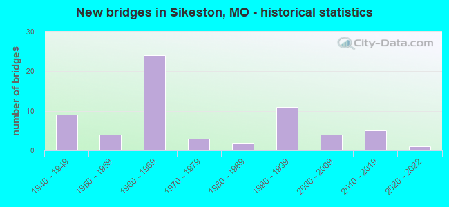
- New bridges - historical statistics
- 91940-1949
- 41950-1959
- 241960-1969
- 31970-1979
- 21980-1989
- 111990-1999
- 42000-2009
- 52010-2019
- 12020-2022
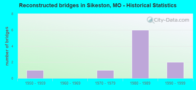
- Reconstructed bridges - Historical Statistics
- 11950-1959
- 01960-1969
- 11970-1979
- 61980-1989
- 21990-1999
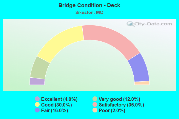
- Bridge Condition - Deck
- 4.0%Excellent
- 12.0%Very good
- 30.0%Good
- 36.0%Satisfactory
- 16.0%Fair
- 2.0%Poor
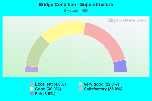
- Bridge Condition - Superstructure
- 4.0%Excellent
- 22.0%Very good
- 30.0%Good
- 36.0%Satisfactory
- 8.0%Fair
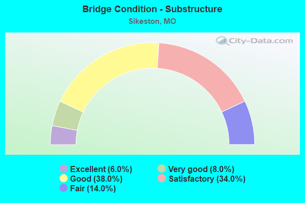
- Bridge Condition - Substructure
- 6.0%Excellent
- 8.0%Very good
- 38.0%Good
- 34.0%Satisfactory
- 14.0%Fair
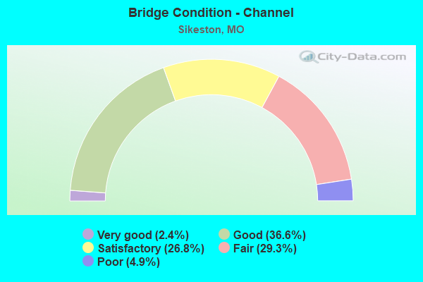
- Bridge Condition - Channel
- 2.4%Very good
- 36.6%Good
- 26.8%Satisfactory
- 29.3%Fair
- 4.9%Poor
Find on map >> Show street view
Structure Number: 12172, Location: S 3 T 25 N R 13 E (Lat: 36.837267, Lng: -89.646244), Route carried "on" structure: County highway 1, Year Built: 1949, Year Reconstructed: 1988, Status: Open, Structure Length: 2.87m (9.42ft), Average Daily Traffic: 35 (year 2021), Truck Traffic: 10%, Average Future Daily Traffic: 47 (year 2041), Features Intersected: DRAIN DTCH, Facility Carried by Structure: COUNTY RD 824
Minimum Vertical Clearance: 30+ m (98+ ft), Kilometerpoint: 3.862, Lanes on structure: 2, Owner: County Highway Agency, Approaching Roadway Width: 7.0m (23.0ft), Skew: 2 degrees, Material/Design: Prestressed concrete, Design/Construction: Tee Beam, Number Of Spans In Main Unit: 3, Length of Maximum Span: 11.0m (36.1ft), Curb-To-Curb Width: 7.4m (24.3ft), Out-to-Out Width: 7.4m (24.3ft)
Condition: Deck: Good, Superstructure: Good, Substructure: Good, Channel: Good, Operating Rating: 67.5 metric tons, Method Used To Determine Operating Rating: Allowable Stress (AS), Inventory Rating: 49.5 metric tons, Method Used To Determine Inventory Rating: Allowable Stress (AS), Structural Evaluation: Better than present minimum criteria, Deck Geometry: Equal to present minimum criteria, Waterway Adequacy: Equal to present desirable criteria, Approach Roadway Alignment: Better than present minimum criteria, Designated Inspection Frequency: Every 24 months, Inspection Date: December 2020, Deck Structure Type: Concrete Cast-file-Place, Wearing Surface/Protective System: Wearing Surface: Bituminous
Find on map >> Show street view
Structure Number: 12198, Location: S 2 T 25 N R 13 E (Lat: 36.837106, Lng: -89.614828), Route carried "on" structure: County highway 2, Year Built: 1990, Status: Open, Structure Length: 2.44m (8.01ft), Average Daily Traffic: 60 (year 2021), Truck Traffic: 10%, Average Future Daily Traffic: 81 (year 2041), Design Load: HS 20, Features Intersected: DRAIN DTCH
Minimum Vertical Clearance: 30+ m (98+ ft), Kilometerpoint: 1.609, Lanes on structure: 2, Owner: County Highway Agency, Approaching Roadway Width: 7.3m (24.0ft), Material/Design: Prestressed concrete, Design/Construction: Slab, Number Of Spans In Main Unit: 3, Length of Maximum Span: 9.1m (29.9ft), Curb-To-Curb Width: 7.3m (24.0ft), Out-to-Out Width: 7.3m (24.0ft)
Condition: Deck: Very good, Superstructure: Very good, Substructure: Good, Channel: Good, Operating Rating: 58.5 metric tons, Method Used To Determine Operating Rating: Allowable Stress (AS), Inventory Rating: 32.4 metric tons, Method Used To Determine Inventory Rating: Allowable Stress (AS), Structural Evaluation: Better than present minimum criteria, Deck Geometry: Equal to present minimum criteria, Waterway Adequacy: Equal to present desirable criteria, Approach Roadway Alignment: Equal to present desirable criteria, Designated Inspection Frequency: Every 24 months, Inspection Date: December 2020, Deck Structure Type: Concrete Cast-file-Place, Wearing Surface/Protective System: Wearing Surface: Bituminous
Find on map >> Show street view
Structure Number: 13657, Location: S 4 T 25 N R 14 E (Lat: 36.832278, Lng: -89.552228), Route carried "on" structure: County highway 44, Year Built: 1998, Status: Open, Structure Length: 3.29m (10.79ft), Average Daily Traffic: 50 (year 2021), Truck Traffic: 50%, Average Future Daily Traffic: 68 (year 2041), Design Load: HS 20, Features Intersected: ST JOHNS DRAIN DTC, Facility Carried by Structure: COUNTY RD 806
Minimum Vertical Clearance: 30+ m (98+ ft), Kilometerpoint: 2.430, Lanes on structure: 2, Owner: County Highway Agency, Approaching Roadway Width: 6.1m (20.0ft), Material/Design: Prestressed concrete, Design/Construction: Box Beam or Girders - Multiple, Number Of Spans In Main Unit: 3, Length of Maximum Span: 10.7m (35.1ft), Curb-To-Curb Width: 7.3m (24.0ft), Out-to-Out Width: 7.3m (24.0ft)
Condition: Deck: Very good, Superstructure: Very good, Substructure: Good, Channel: Good, Operating Rating: 53.1 metric tons, Method Used To Determine Operating Rating: Load Factor (LF), Inventory Rating: 36.9 metric tons, Method Used To Determine Inventory Rating: Load Factor (LF), Structural Evaluation: Better than present minimum criteria, Deck Geometry: Equal to present minimum criteria, Waterway Adequacy: Superior to present desirable criteria, Approach Roadway Alignment: Equal to present desirable criteria, Designated Inspection Frequency: Every 24 months, Inspection Date: December 2020, Wearing Surface/Protective System: Wearing Surface: Bituminous
Find on map >> Show street view
Structure Number: 13747, Location: S 9 T 25 N R 14 E (Lat: 36.818172, Lng: -89.551692), Route carried "on" structure: County highway 46, Year Built: 1975, Year Reconstructed: 1986, Status: Posted for load, Structure Length: 2.16m (7.09ft), Average Daily Traffic: 5 (year 2021), Truck Traffic: 10%, Average Future Daily Traffic: 7 (year 2041), Features Intersected: ST JOHNS DRAIN DTC, Facility Carried by Structure: COUNTY RD 808
Minimum Vertical Clearance: 30+ m (98+ ft), Kilometerpoint: 2.253, Lanes on structure: 1, Owner: County Highway Agency, Approaching Roadway Width: 6.7m (22.0ft), Material/Design: Steel, Design/Construction: Stringer/Multi-beam, Number Of Spans In Main Unit: 3, Length of Maximum Span: 7.6m (24.9ft), Curb-To-Curb Width: 4.9m (16.1ft), Out-to-Out Width: 4.9m (16.1ft)
Condition: Deck: Good, Superstructure: Satisfactory, Substructure: Fair, Channel: Good, Operating Rating: 26.1 metric tons, Method Used To Determine Operating Rating: Allowable Stress (AS), Inventory Rating: 17.1 metric tons, Method Used To Determine Inventory Rating: Allowable Stress (AS), Structural Evaluation: Somewhat better than minimum adequacy, Deck Geometry: High priority of corrective action, Waterway Adequacy: Better than present minimum criteria, Approach Roadway Alignment: Equal to present minimum criteria, Bridge Posting: Required (Relationship of Operating Rating to Maximum Legal Load: 10.0 - 19.9% below), Length Of Structure Improvement: 0.30m (0.98ft), Designated Inspection Frequency: Every 24 months, Inspection Date: December 2020, Bridge Improvement Cost: $218,000, Roadway Improvement Cost: $22,000, Total Project Cost: $326,000 ( Estimate for 2022), Deck Structure Type: Wood or Timber, Wearing Surface/Protective System: Wearing Surface: Wood or Timber
Find on map >> Show street view
Structure Number: 14577, Location: S 6 T 26 N R 13 E (Lat: 36.918008, Lng: -89.689183), Route carried "on" structure: County highway 70, Year Built: 1989, Status: Open, Structure Length: 1.49m (4.89ft), Average Daily Traffic: 35 (year 2021), Truck Traffic: 10%, Average Future Daily Traffic: 46 (year 2041), Design Load: HS 20, Features Intersected: LITTLE RVR, Facility Carried by Structure: COUNTY RD 518
Minimum Vertical Clearance: 30+ m (98+ ft), Kilometerpoint: 3.219, Lanes on structure: 1, Owner: County Highway Agency, Approaching Roadway Width: 7.3m (24.0ft), Skew: 4 degrees, Material/Design: Steel, Design/Construction: Stringer/Multi-beam, Number Of Spans In Main Unit: 1, Length of Maximum Span: 14.6m (47.9ft), Curb-To-Curb Width: 5.2m (17.1ft), Out-to-Out Width: 5.5m (18.0ft)
Condition: Deck: Good, Superstructure: Good, Substructure: Good, Channel: Good, Operating Rating: 62.1 metric tons, Method Used To Determine Operating Rating: Allowable Stress (AS), Inventory Rating: 45.0 metric tons, Method Used To Determine Inventory Rating: Allowable Stress (AS), Structural Evaluation: Better than present minimum criteria, Deck Geometry: High priority of corrective action, Waterway Adequacy: Equal to present minimum criteria, Approach Roadway Alignment: Equal to present minimum criteria, Designated Inspection Frequency: Every 24 months, Inspection Date: January 2021, Deck Structure Type: Concrete Cast-file-Place, Wearing Surface/Protective System: Wearing Surface: Monolithic Concrete
Find on map >> Show street view
Structure Number: 16195, Location: S 32 T 27 N R 14 E (Lat: 36.935608, Lng: -89.559194), Route carried "on" structure: County highway 113, Year Built: 1982, Status: Posted for load, Structure Length: 3.05m (10.01ft), Average Daily Traffic: 100 (year 2021), Truck Traffic: 10%, Average Future Daily Traffic: 140 (year 2041), Features Intersected: ST JOHN'S DTCH, Facility Carried by Structure: COUNTY RD 472
Minimum Vertical Clearance: 30+ m (98+ ft), Kilometerpoint: 2.736, Lanes on structure: 2, Owner: Local Agency, Approaching Roadway Width: 5.9m (19.4ft), Skew: 3 degrees, Material/Design: Steel, Design/Construction: Stringer/Multi-beam, Number Of Spans In Main Unit: 4, Length of Maximum Span: 8.5m (27.9ft), Curb-To-Curb Width: 5.9m (19.4ft), Out-to-Out Width: 5.9m (19.4ft)
Condition: Deck: Satisfactory, Superstructure: Satisfactory, Substructure: Satisfactory, Channel: Fair, Operating Rating: 19.8 metric tons, Method Used To Determine Operating Rating: Load Factor (LF), Inventory Rating: 11.7 metric tons, Method Used To Determine Inventory Rating: Load Factor (LF), Structural Evaluation: Meets minimum limits, Deck Geometry: Meets minimum limits, Waterway Adequacy: Better than present minimum criteria, Approach Roadway Alignment: Better than present minimum criteria, Bridge Posting: Required (Relationship of Operating Rating to Maximum Legal Load: > 39.9% below), Designated Inspection Frequency: Every 24 months, Inspection Date: January 2021, Deck Structure Type: Concrete Cast-file-Place, Wearing Surface/Protective System: Wearing Surface: Bituminous
Find on map >> Show street view
Structure Number: 16355, Location: S 28 T 26 N R 13 E (Lat: 36.867797, Lng: -89.650828), Route carried "on" structure: County highway 117, Year Built: 1960, Year Reconstructed: 1988, Status: Open, Structure Length: 2.04m (6.69ft), Average Daily Traffic: 30 (year 2021), Truck Traffic: 10%, Average Future Daily Traffic: 42 (year 2041), Design Load: H 10, Features Intersected: DTCH NO 2, Facility Carried by Structure: COUNTY RD 480
Minimum Vertical Clearance: 30+ m (98+ ft), Kilometerpoint: 4.506, Lanes on structure: 2, Owner: Local Agency, Approaching Roadway Width: 7.0m (23.0ft), Material/Design: Steel, Design/Construction: Stringer/Multi-beam, Number Of Spans In Main Unit: 3, Length of Maximum Span: 9.1m (29.9ft), Curb-To-Curb Width: 7.3m (24.0ft), Out-to-Out Width: 7.7m (25.3ft)
Condition: Deck: Satisfactory, Superstructure: Good, Substructure: Satisfactory, Channel: Fair, Operating Rating: 40.5 metric tons, Method Used To Determine Operating Rating: Allowable Stress (AS), Inventory Rating: 26.1 metric tons, Method Used To Determine Inventory Rating: Allowable Stress (AS), Structural Evaluation: Equal to present minimum criteria, Deck Geometry: Equal to present minimum criteria, Waterway Adequacy: Better than present minimum criteria, Approach Roadway Alignment: Equal to present desirable criteria, Designated Inspection Frequency: Every 24 months, Inspection Date: January 2021, Deck Structure Type: Concrete Cast-file-Place, Wearing Surface/Protective System: Wearing Surface: Monolithic Concrete
Find on map >> Show street view
Structure Number: 16356, Location: S 27 T 26 N R 13 E (Lat: 36.868000, Lng: -89.641653), Route carried "on" structure: County highway 117, Year Built: 1960, Year Reconstructed: 1988, Status: Posted for load, Structure Length: 2.47m (8.10ft), Average Daily Traffic: 30 (year 2021), Truck Traffic: 10%, Average Future Daily Traffic: 42 (year 2041), Design Load: H 10, Features Intersected: DTCH NO 1, Facility Carried by Structure: COUNTY RD 480
Minimum Vertical Clearance: 30+ m (98+ ft), Kilometerpoint: 5.311, Lanes on structure: 2, Owner: Local Agency, Approaching Roadway Width: 7.0m (23.0ft), Material/Design: Steel, Design/Construction: Stringer/Multi-beam, Number Of Spans In Main Unit: 3, Length of Maximum Span: 12.2m (40.0ft), Curb-To-Curb Width: 7.3m (24.0ft), Out-to-Out Width: 7.7m (25.3ft)
Condition: Deck: Good, Superstructure: Satisfactory, Substructure: Satisfactory, Channel: Good, Operating Rating: 49.5 metric tons, Method Used To Determine Operating Rating: Allowable Stress (AS), Inventory Rating: 16.2 metric tons, Method Used To Determine Inventory Rating: Allowable Stress (AS), Structural Evaluation: Somewhat better than minimum adequacy, Deck Geometry: Equal to present minimum criteria, Waterway Adequacy: Better than present minimum criteria, Approach Roadway Alignment: Better than present minimum criteria, Designated Inspection Frequency: Every 24 months, Inspection Date: January 2021, Deck Structure Type: Concrete Cast-file-Place, Wearing Surface/Protective System: Wearing Surface: Monolithic Concrete
Find on map >> Show street view
Structure Number: 16463, Location: S 9 T 26 N R 13 E (Lat: 36.904094, Lng: -89.660661), Route carried "on" structure: County highway 121, Year Built: 1962, Year Reconstructed: 1990, Status: Posted for load, Structure Length: 2.16m (7.09ft), Average Daily Traffic: 35 (year 2021), Truck Traffic: 10%, Average Future Daily Traffic: 49 (year 2041), Features Intersected: DTCH NO 2, Facility Carried by Structure: COUNTY RD 476
Minimum Vertical Clearance: 30+ m (98+ ft), Kilometerpoint: 2.092, Lanes on structure: 2, Owner: Local Agency, Approaching Roadway Width: 6.7m (22.0ft), Material/Design: Steel, Design/Construction: Stringer/Multi-beam, Number Of Spans In Main Unit: 3, Length of Maximum Span: 9.1m (29.9ft), Curb-To-Curb Width: 5.9m (19.4ft), Out-to-Out Width: 6.4m (21.0ft)
Condition: Deck: Good, Superstructure: Good, Substructure: Satisfactory, Channel: Fair, Operating Rating: 28.8 metric tons, Method Used To Determine Operating Rating: Allowable Stress (AS), Inventory Rating: 17.1 metric tons, Method Used To Determine Inventory Rating: Allowable Stress (AS), Structural Evaluation: Somewhat better than minimum adequacy, Deck Geometry: Meets minimum limits, Waterway Adequacy: Better than present minimum criteria, Approach Roadway Alignment: Equal to present minimum criteria, Designated Inspection Frequency: Every 24 months, Inspection Date: January 2021, Deck Structure Type: Concrete Cast-file-Place, Wearing Surface/Protective System: Wearing Surface: Monolithic Concrete
Find on map >> Show street view
Structure Number: 16478, Location: S 32 T 27 N R 13 E (Lat: 36.932933, Lng: -89.670725), Route carried "on" structure: County highway 122, Year Built: 1965, Year Reconstructed: 1990, Status: Open, Structure Length: 2.26m (7.41ft), Average Daily Traffic: 20 (year 2021), Truck Traffic: 10%, Average Future Daily Traffic: 28 (year 2041), Features Intersected: DTCH NO 2, Facility Carried by Structure: COUNTY RD 470
Minimum Vertical Clearance: 30+ m (98+ ft), Kilometerpoint: 0.966, Lanes on structure: 2, Owner: Local Agency, Approaching Roadway Width: 6.7m (22.0ft), Material/Design: Steel, Design/Construction: Stringer/Multi-beam, Number Of Spans In Main Unit: 3, Length of Maximum Span: 7.6m (24.9ft), Curb-To-Curb Width: 7.3m (24.0ft), Out-to-Out Width: 7.6m (24.9ft)
Condition: Deck: Satisfactory, Superstructure: Good, Substructure: Fair, Channel: Poor, Operating Rating: 35.1 metric tons, Method Used To Determine Operating Rating: Allowable Stress (AS), Inventory Rating: 20.7 metric tons, Method Used To Determine Inventory Rating: Allowable Stress (AS), Structural Evaluation: Somewhat better than minimum adequacy, Deck Geometry: Equal to present minimum criteria, Waterway Adequacy: Better than present minimum criteria, Approach Roadway Alignment: Equal to present minimum criteria, Designated Inspection Frequency: Every 24 months, Inspection Date: January 2021, Deck Structure Type: Concrete Cast-file-Place, Wearing Surface/Protective System: Wearing Surface: Monolithic Concrete
Find on map >> Show street view
Structure Number: 16504, Location: S 33 T 27 N R 13 E (Lat: 36.937097, Lng: -89.653269), Route carried "on" structure: County highway 123, Year Built: 1962, Year Reconstructed: 1983, Status: Posted for load, Structure Length: 1.58m (5.18ft), Average Daily Traffic: 25 (year 2021), Truck Traffic: 10%, Average Future Daily Traffic: 35 (year 2041), Design Load: H 10, Features Intersected: DTCH NO 1, Facility Carried by Structure: COUNTY RD 468
Minimum Vertical Clearance: 30+ m (98+ ft), Kilometerpoint: 0.161, Lanes on structure: 2, Owner: County Highway Agency, Approaching Roadway Width: 6.7m (22.0ft), Material/Design: Steel, Design/Construction: Stringer/Multi-beam, Number Of Spans In Main Unit: 1, Length of Maximum Span: 14.9m (48.9ft), Curb-To-Curb Width: 7.9m (25.9ft), Out-to-Out Width: 8.2m (26.9ft)
Condition: Deck: Satisfactory, Superstructure: Satisfactory, Substructure: Satisfactory, Channel: Good, Operating Rating: 29.7 metric tons, Method Used To Determine Operating Rating: Allowable Stress (AS), Inventory Rating: 16.2 metric tons, Method Used To Determine Inventory Rating: Allowable Stress (AS), Structural Evaluation: Somewhat better than minimum adequacy, Deck Geometry: Equal to present minimum criteria, Waterway Adequacy: Equal to present desirable criteria, Approach Roadway Alignment: Equal to present minimum criteria, Designated Inspection Frequency: Every 24 months, Inspection Date: January 2021, Deck Structure Type: Concrete Cast-file-Place, Wearing Surface/Protective System: Wearing Surface: Monolithic Concrete
Find on map >> Show street view
Structure Number: 16612, Location: S 22 T 27 N R 13 E (Lat: 36.974492, Lng: -89.639475), Route carried "on" structure: County highway 126, Year Built: 1990, Status: Open, Structure Length: 1.28m (4.20ft), Average Daily Traffic: 50 (year 2021), Truck Traffic: 10%, Average Future Daily Traffic: 70 (year 2041), Design Load: H 10, Features Intersected: DTCH NO 4, Facility Carried by Structure: COUNTY RD 452
Minimum Vertical Clearance: 30+ m (98+ ft), Kilometerpoint: 2.897, Lanes on structure: 2, Owner: County Highway Agency, Approaching Roadway Width: 6.7m (22.0ft), Material/Design: Steel, Design/Construction: Stringer/Multi-beam, Number Of Spans In Main Unit: 1, Length of Maximum Span: 11.6m (38.1ft), Curb-To-Curb Width: 6.6m (21.7ft), Out-to-Out Width: 6.7m (22.0ft)
Condition: Deck: Very good, Superstructure: Satisfactory, Substructure: Good, Channel: Good, Operating Rating: 35.1 metric tons, Method Used To Determine Operating Rating: Allowable Stress (AS), Inventory Rating: 21.6 metric tons, Method Used To Determine Inventory Rating: Allowable Stress (AS), Structural Evaluation: Equal to present minimum criteria, Deck Geometry: Somewhat better than minimum adequacy, Waterway Adequacy: Equal to present desirable criteria, Approach Roadway Alignment: Equal to present desirable criteria, Designated Inspection Frequency: Every 24 months, Inspection Date: January 2021, Deck Structure Type: Concrete Cast-file-Place, Wearing Surface/Protective System: Wearing Surface: Monolithic Concrete
Find on map >> Show street view
Structure Number: 16617, Location: S 28 T 27 N R 13 E (Lat: 36.958797, Lng: -89.659244), Route carried "on" structure: County highway 127, Year Built: 1964, Year Reconstructed: 1988, Status: Open, Structure Length: 2.01m (6.59ft), Average Daily Traffic: 25 (year 2021), Truck Traffic: 10%, Average Future Daily Traffic: 35 (year 2041), Design Load: H 10, Features Intersected: DTCH NO 1, Facility Carried by Structure: COUNTY RD 450
Minimum Vertical Clearance: 30+ m (98+ ft), Kilometerpoint: 0.161, Lanes on structure: 2, Owner: County Highway Agency, Approaching Roadway Width: 7.3m (24.0ft), Material/Design: Prestressed concrete, Design/Construction: Box Beam or Girders - Multiple, Number Of Spans In Main Unit: 3, Length of Maximum Span: 7.6m (24.9ft), Curb-To-Curb Width: 7.3m (24.0ft), Out-to-Out Width: 7.3m (24.0ft)
Condition: Deck: Satisfactory, Superstructure: Satisfactory, Substructure: Satisfactory, Channel: Satisfactory, Operating Rating: 49.5 metric tons, Method Used To Determine Operating Rating: Allowable Stress (AS), Inventory Rating: 32.4 metric tons, Method Used To Determine Inventory Rating: Allowable Stress (AS), Structural Evaluation: Equal to present minimum criteria, Deck Geometry: Equal to present minimum criteria, Waterway Adequacy: Equal to present desirable criteria, Approach Roadway Alignment: Equal to present minimum criteria, Designated Inspection Frequency: Every 24 months, Inspection Date: January 2021, Deck Structure Type: Concrete Cast-file-Place, Wearing Surface/Protective System: Wearing Surface: Bituminous
Find on map >> Show street view
Structure Number: 16797, Location: S 30 T 27 N R 14 E (Lat: 36.950111, Lng: -89.576369), Route carried "on" structure: County highway 452, Year Built: 1998, Status: Open, Structure Length: 1.89m (6.20ft), Average Daily Traffic: 80 (year 2021), Truck Traffic: 10%, Average Future Daily Traffic: 112 (year 2041), Features Intersected: ST JOHN'S DTCH, Facility Carried by Structure: COUNTY RD 450
Minimum Vertical Clearance: 30+ m (98+ ft), Kilometerpoint: 2.575, Lanes on structure: 2, Owner: County Highway Agency, Approaching Roadway Width: 6.7m (22.0ft), Skew: 3 degrees, Material/Design: Steel, Design/Construction: Stringer/Multi-beam, Number Of Spans In Main Unit: 1, Length of Maximum Span: 17.1m (56.1ft), Curb-To-Curb Width: 6.6m (21.7ft), Out-to-Out Width: 6.8m (22.3ft)
Condition: Deck: Satisfactory, Superstructure: Good, Substructure: Satisfactory, Channel: Satisfactory, Operating Rating: 54.0 metric tons, Method Used To Determine Operating Rating: Allowable Stress (AS), Inventory Rating: 32.4 metric tons, Method Used To Determine Inventory Rating: Allowable Stress (AS), Structural Evaluation: Equal to present minimum criteria, Deck Geometry: Somewhat better than minimum adequacy, Waterway Adequacy: Better than present minimum criteria, Approach Roadway Alignment: Equal to present desirable criteria, Designated Inspection Frequency: Every 24 months, Inspection Date: January 2021, Deck Structure Type: Wood or Timber, Wearing Surface/Protective System: Wearing Surface: Bituminous
Find on map >> Show street view
Structure Number: 29129, Location: S 29 T 26 N R 14 E (Lat: 36.863950, Lng: -89.559717), Route carried "on" structure: US 60, Year Built: 2002, Status: Open, Structure Length: 4.42m (14.50ft), Average Daily Traffic: 6,735 (year 2021), Truck Traffic: 29%, Average Future Daily Traffic: 12,460 (year 2041), Design Load: HS 20+Mod, Features Intersected: ST JOHN'S DTCH
Minimum Vertical Clearance: 30+ m (98+ ft), Kilometerpoint: 507.419, Lanes on structure: 2, Base Highway Network: Yes, Owner: State Highway Agency, Approaching Roadway Width: 11.6m (38.1ft), Skew: 10 degrees, Material/Design: Prestressed concrete continuous, Design/Construction: Stringer/Multi-beam, Number Of Spans In Main Unit: 3, Length of Maximum Span: 17.1m (56.1ft), Curb-To-Curb Width: 11.6m (38.1ft), Out-to-Out Width: 12.4m (40.7ft)
Condition: Deck: Good, Superstructure: Very good, Substructure: Satisfactory, Channel: Satisfactory, Operating Rating: 91.8 metric tons, Method Used To Determine Operating Rating: Load Factor (LF), Inventory Rating: 53.1 metric tons, Method Used To Determine Inventory Rating: Load Factor (LF), Structural Evaluation: Equal to present minimum criteria, Deck Geometry: Equal to present minimum criteria, Waterway Adequacy: Superior to present desirable criteria, Approach Roadway Alignment: Equal to present desirable criteria, Designated Inspection Frequency: Every 24 months, Inspection Date: December 2020, Deck Structure Type: Concrete Cast-file-Place, Wearing Surface/Protective System: Wearing Surface: Monolithic Concrete, Deck Protection: Epoxy Coated Reinforcing
Find on map >> Show street view
Structure Number: 2913, Location: S 17 T 28 N R 32 W (Lat: 37.141831, Lng: -94.453972), Route carried "on" structure: State highway 171, Year Built: 1977, Status: Open, Structure Length: 7.96m (26.12ft), Average Daily Traffic: 5,401 (year 2021), Truck Traffic: 5%, Average Future Daily Traffic: 8,372 (year 2041), Design Load: HS 20, Features Intersected: MNA RR
Minimum Vertical Clearance: 30+ m (98+ ft), Kilometerpoint: 12.286, Lanes on structure: 2, Base Highway Network: Yes, Owner: State Highway Agency, Approaching Roadway Width: 7.3m (24.0ft), Skew: 10 degrees, Material/Design: Prestressed concrete continuous, Design/Construction: Stringer/Multi-beam, Number Of Spans In Main Unit: 5, Length of Maximum Span: 20.1m (65.9ft), Curb or Sidewalk Widths: Left: 0.2m (0.7ft), Right: 0.2m (0.7ft), Curb-To-Curb Width: 12.0m (39.4ft), Out-to-Out Width: 13.0m (42.7ft)
Condition: Deck: Good, Superstructure: Satisfactory, Substructure: Satisfactory, Operating Rating: 71.1 metric tons, Method Used To Determine Operating Rating: Load Factor (LF), Inventory Rating: 34.2 metric tons, Method Used To Determine Inventory Rating: Load Factor (LF), Structural Evaluation: Equal to present minimum criteria, Deck Geometry: Better than present minimum criteria, Underclear: Meets minimum limits, Approach Roadway Alignment: Equal to present desirable criteria, Designated Inspection Frequency: Every 24 months, Inspection Date: August 2021, Deck Structure Type: Concrete Cast-file-Place, Wearing Surface/Protective System: Wearing Surface: Bituminous, Membrane: Built-up
Find on map >> Show street view
Structure Number: 2913, Location: S 29 T 26 N R 14 E (Lat: 36.864172, Lng: -89.559781), Route carried "on" structure: US 60, Year Built: 2002, Status: Open, Structure Length: 4.54m (14.90ft), Average Daily Traffic: 7,366 (year 2021), Truck Traffic: 22%, Average Future Daily Traffic: 13,627 (year 2041), Design Load: HS 25 or greater, Features Intersected: ST JOHN'S DTCH
Minimum Vertical Clearance: 30+ m (98+ ft), Kilometerpoint: 41.759, Lanes on structure: 2, Base Highway Network: Yes, Owner: State Highway Agency, Approaching Roadway Width: 11.6m (38.1ft), Skew: 10 degrees, Material/Design: Prestressed concrete continuous, Design/Construction: Stringer/Multi-beam, Number Of Spans In Main Unit: 3, Length of Maximum Span: 17.1m (56.1ft), Curb-To-Curb Width: 11.6m (38.1ft), Out-to-Out Width: 12.4m (40.7ft)
Condition: Deck: Good, Superstructure: Very good, Substructure: Satisfactory, Channel: Satisfactory, Operating Rating: 91.8 metric tons, Method Used To Determine Operating Rating: Load Factor (LF), Inventory Rating: 53.1 metric tons, Method Used To Determine Inventory Rating: Load Factor (LF), Structural Evaluation: Equal to present minimum criteria, Deck Geometry: Equal to present minimum criteria, Waterway Adequacy: Superior to present desirable criteria, Approach Roadway Alignment: Equal to present desirable criteria, Designated Inspection Frequency: Every 24 months, Inspection Date: December 2020, Deck Structure Type: Concrete Cast-file-Place, Wearing Surface/Protective System: Wearing Surface: Monolithic Concrete, Deck Protection: Epoxy Coated Reinforcing
Find on map >> Show street view
Structure Number: 2927, Location: S 34 T 26 N R 13 E (Lat: 36.858236, Lng: -89.649739), Route carried "on" structure: State highway 114, Year Built: 1977, Status: Open, Structure Length: 3.32m (10.89ft), Average Daily Traffic: 1,353 (year 2021), Truck Traffic: 5%, Average Future Daily Traffic: 2,097 (year 2041), Design Load: H 20, Features Intersected: DRAIN DTCH #2
Minimum Vertical Clearance: 30+ m (98+ ft), Kilometerpoint: 30.201, Lanes on structure: 2, Owner: State Highway Agency, Approaching Roadway Width: 7.3m (24.0ft), Material/Design: Concrete continuous, Design/Construction: Slab, Number Of Spans In Main Unit: 3, Length of Maximum Span: 13.4m (44.0ft), Curb-To-Curb Width: 10.4m (34.1ft), Out-to-Out Width: 11.4m (37.4ft)
Condition: Deck: Good, Superstructure: Good, Substructure: Good, Channel: Satisfactory, Operating Rating: 65.7 metric tons, Method Used To Determine Operating Rating: Allowable Stress (AS), Inventory Rating: 36.0 metric tons, Method Used To Determine Inventory Rating: Allowable Stress (AS), Structural Evaluation: Better than present minimum criteria, Deck Geometry: Equal to present minimum criteria, Waterway Adequacy: Equal to present desirable criteria, Approach Roadway Alignment: Equal to present desirable criteria, Designated Inspection Frequency: Every 24 months, Inspection Date: December 2020, Deck Structure Type: Concrete Cast-file-Place, Wearing Surface/Protective System: Wearing Surface: Bituminous, Deck Protection: Internally Sealed
Find on map >> Show street view
Structure Number: 2972, Location: S 10 T 25 N R 13 E (Lat: 36.817181, Lng: -89.640542), Route carried "on" structure: County highway 7, Year Built: 2002, Status: Open, Structure Length: 2.44m (8.01ft), Average Daily Traffic: 35 (year 2021), Truck Traffic: 10%, Average Future Daily Traffic: 47 (year 2041), Features Intersected: DRAIN DTCH, Facility Carried by Structure: COUNTY RD 828
Minimum Vertical Clearance: 30+ m (98+ ft), Kilometerpoint: 2.575, Lanes on structure: 2, Owner: County Highway Agency, Approaching Roadway Width: 8.2m (26.9ft), Material/Design: Prestressed concrete continuous, Design/Construction: Tee Beam, Number Of Spans In Main Unit: 3, Length of Maximum Span: 6.4m (21.0ft), Curb-To-Curb Width: 7.3m (24.0ft), Out-to-Out Width: 7.5m (24.6ft)
Condition: Deck: Good, Superstructure: Good, Substructure: Good, Channel: Good, Inventory Rating: 68.4 metric tons, Method Used To Determine Inventory Rating: Load Factor (LF), Structural Evaluation: Better than present minimum criteria, Deck Geometry: Equal to present minimum criteria, Waterway Adequacy: Equal to present desirable criteria, Approach Roadway Alignment: Equal to present desirable criteria, Designated Inspection Frequency: Every 24 months, Inspection Date: December 2020, Deck Structure Type: Concrete Precast Panels
Find on map >> Show street view
Structure Number: 31264, Location: S 27 T 26 N R 14 E (Lat: 36.869569, Lng: -89.524261), Route carried "on" structure: County highway 801, Year Built: 2004, Status: Open, Structure Length: 3.44m (11.29ft), Average Daily Traffic: 110 (year 2021), Truck Traffic: 10%, Average Future Daily Traffic: 149 (year 2041), Design Load: HS 20, Features Intersected: NORTHCUT DRAIN DTC
Minimum Vertical Clearance: 30+ m (98+ ft), Kilometerpoint: 0.000, Lanes on structure: 2, Owner: County Highway Agency, Approaching Roadway Width: 7.3m (24.0ft), Material/Design: Prestressed concrete continuous, Design/Construction: Box Beam or Girders - Multiple, Number Of Spans In Main Unit: 3, Length of Maximum Span: 12.2m (40.0ft), Curb-To-Curb Width: 7.3m (24.0ft), Out-to-Out Width: 7.3m (24.0ft)
Condition: Deck: Good, Superstructure: Very good, Substructure: Good, Channel: Good, Operating Rating: 52.2 metric tons, Method Used To Determine Operating Rating: Load Factor (LF), Inventory Rating: 34.2 metric tons, Method Used To Determine Inventory Rating: Load Factor (LF), Structural Evaluation: Better than present minimum criteria, Deck Geometry: Somewhat better than minimum adequacy, Waterway Adequacy: Superior to present desirable criteria, Approach Roadway Alignment: Equal to present desirable criteria, Designated Inspection Frequency: Every 24 months, Inspection Date: December 2020, Deck Structure Type: Concrete Cast-file-Place, Wearing Surface/Protective System: Wearing Surface: Gravel
Find on map >> Show street view
Structure Number: 33042, Location: S 4 T 26 N R 13 E (Lat: 36.918442, Lng: -89.666061), Route carried "on" structure: State highway ZZ, Year Built: 2010, Status: Open, Structure Length: 3.11m (10.20ft), Average Daily Traffic: 710 (year 2021), Truck Traffic: 21%, Average Future Daily Traffic: 1,030 (year 2041), Design Load: HS 20, Features Intersected: DRAIN DTCH 2, DIST
Minimum Vertical Clearance: 30+ m (98+ ft), Kilometerpoint: 2.054, Lanes on structure: 2, Owner: State Highway Agency, Approaching Roadway Width: 7.3m (24.0ft), Skew: 1 degrees, Material/Design: Concrete continuous, Design/Construction: Slab, Number Of Spans In Main Unit: 3, Length of Maximum Span: 12.2m (40.0ft), Curb-To-Curb Width: 7.3m (24.0ft), Out-to-Out Width: 7.9m (25.9ft)
Condition: Deck: Satisfactory, Superstructure: Satisfactory, Substructure: Very good, Channel: Good, Operating Rating: 66.6 metric tons, Method Used To Determine Operating Rating: Load Factor (LF), Inventory Rating: 40.5 metric tons, Method Used To Determine Inventory Rating: Load Factor (LF), Structural Evaluation: Equal to present minimum criteria, Deck Geometry: Meets minimum limits, Waterway Adequacy: Superior to present desirable criteria, Approach Roadway Alignment: Equal to present desirable criteria, Designated Inspection Frequency: Every 24 months, Inspection Date: Febuary 2021, Deck Structure Type: Concrete Cast-file-Place, Wearing Surface/Protective System: Wearing Surface: Monolithic Concrete, Deck Protection: Epoxy Coated Reinforcing
Find on map >> Show street view
Structure Number: 34431, Location: S 34 T 27 N R 13 E (Lat: 36.939444, Lng: -89.634722), Route carried "on" structure: County highway 123, Year Built: 2013, Status: Open, Structure Length: 1.62m (5.31ft), Average Daily Traffic: 100 (year 2021), Truck Traffic: 50%, Average Future Daily Traffic: 140 (year 2041), Design Load: HS 20, Features Intersected: DRAIN DTCH #4, Facility Carried by Structure: COUNTY RD 468
Minimum Vertical Clearance: 30+ m (98+ ft), Kilometerpoint: 1.931, Lanes on structure: 2, Owner: County Highway Agency, Approaching Roadway Width: 6.7m (22.0ft), Skew: 2 degrees, Material/Design: Concrete, Design/Construction: Box Beam or Girders - Single/Spread, Number Of Spans In Main Unit: 1, Length of Maximum Span: 15.2m (49.9ft), Curb-To-Curb Width: 7.3m (24.0ft), Out-to-Out Width: 7.3m (24.0ft)
Condition: Deck: Good, Superstructure: Good, Substructure: Excellent, Channel: Good, Operating Rating: 54.0 metric tons, Method Used To Determine Operating Rating: Load Factor (LF), Inventory Rating: 32.4 metric tons, Method Used To Determine Inventory Rating: Load Factor (LF), Structural Evaluation: Better than present minimum criteria, Deck Geometry: Equal to present minimum criteria, Waterway Adequacy: Superior to present desirable criteria, Approach Roadway Alignment: Equal to present desirable criteria, Designated Inspection Frequency: Every 24 months, Inspection Date: January 2021, Deck Structure Type: Concrete Precast Panels, Wearing Surface/Protective System: Wearing Surface: Bituminous
Find on map >> Show street view
Structure Number: 34704, Location: S 23 T 26 N R 13 E (Lat: 36.883028, Lng: -89.624056), Route carried "on" structure: County highway 400, Year Built: 2014, Status: Open, Structure Length: 2.50m (8.20ft), Average Daily Traffic: 150 (year 2021), Truck Traffic: 50%, Average Future Daily Traffic: 218 (year 2041), Design Load: HS 20, Features Intersected: RICHLAND DRAIN DTC, Facility Carried by Structure: WAKEFIELD AVE
Minimum Vertical Clearance: 30+ m (98+ ft), Kilometerpoint: 0.483, Lanes on structure: 2, Owner: City or Municipal Highway Agency, Approaching Roadway Width: 8.5m (27.9ft), Material/Design: Prestressed concrete, Design/Construction: Box Beam or Girders - Multiple, Number Of Spans In Main Unit: 3, Length of Maximum Span: 9.1m (29.9ft), Curb-To-Curb Width: 8.5m (27.9ft), Out-to-Out Width: 8.5m (27.9ft)
Condition: Deck: Excellent, Superstructure: Good, Substructure: Good, Channel: Good, Operating Rating: 55.8 metric tons, Method Used To Determine Operating Rating: Load Factor (LF), Inventory Rating: 45.0 metric tons, Method Used To Determine Inventory Rating: Load Factor (LF), Structural Evaluation: Better than present minimum criteria, Deck Geometry: Equal to present minimum criteria, Waterway Adequacy: Superior to present desirable criteria, Approach Roadway Alignment: Equal to present desirable criteria, Designated Inspection Frequency: Every 24 months, Inspection Date: January 2021, Deck Structure Type: Concrete Cast-file-Place, Wearing Surface/Protective System: Wearing Surface: Gravel
Find on map >> Show street view
Structure Number: 34966, Location: S 11 T 25 N R 13 E (Lat: 36.817778, Lng: -89.613528), Route carried "on" structure: County highway 800, Year Built: 2015, Status: Open, Structure Length: 2.47m (8.10ft), Average Daily Traffic: 15 (year 2021), Truck Traffic: 10%, Average Future Daily Traffic: 20 (year 2041), Design Load: HS 20, Features Intersected: DRAIN DTCH 23, Facility Carried by Structure: COUNTY RD 828
Minimum Vertical Clearance: 30+ m (98+ ft), Kilometerpoint: 1.287, Lanes on structure: 2, Owner: County Highway Agency, Approaching Roadway Width: 6.7m (22.0ft), Skew: 3 degrees, Material/Design: Concrete, Design/Construction: Box Beam or Girders - Multiple, Number Of Spans In Main Unit: 3, Length of Maximum Span: 8.2m (26.9ft), Curb-To-Curb Width: 7.6m (24.9ft), Out-to-Out Width: 7.8m (25.6ft)
Condition: Deck: Very good, Superstructure: Very good, Substructure: Very good, Channel: Very good, Operating Rating: 54.0 metric tons, Method Used To Determine Operating Rating: Load Factor (LF), Inventory Rating: 32.4 metric tons, Method Used To Determine Inventory Rating: Load Factor (LF), Structural Evaluation: Equal to present desirable criteria, Deck Geometry: Equal to present minimum criteria, Waterway Adequacy: Superior to present desirable criteria, Approach Roadway Alignment: Equal to present desirable criteria, Designated Inspection Frequency: Every 24 months, Inspection Date: December 2020, Deck Structure Type: Concrete Cast-file-Place, Wearing Surface/Protective System: Wearing Surface: Bituminous
Find on map >> Show street view
Structure Number: 36054, Location: S 3 T 25 N R 14 E (Lat: 36.833164, Lng: -89.524817), Route carried "on" structure: State highway AA, Year Built: 2019, Status: Open, Structure Length: 4.22m (13.85ft), Average Daily Traffic: 243 (year 2021), Truck Traffic: 13%, Average Future Daily Traffic: 377 (year 2041), Features Intersected: N CUT DTCH
Minimum Vertical Clearance: 30+ m (98+ ft), Kilometerpoint: 7.377, Lanes on structure: 2, Owner: State Highway Agency, Approaching Roadway Width: 7.9m (25.9ft), Material/Design: Prestressed concrete, Design/Construction: Box Beam or Girders - Single/Spread, Number Of Spans In Main Unit: 3, Length of Maximum Span: 14.9m (48.9ft), Curb-To-Curb Width: 7.9m (25.9ft), Out-to-Out Width: 8.7m (28.5ft)
Condition: Deck: Good, Superstructure: Excellent, Substructure: Excellent, Channel: Good, Operating Rating: 90.0 metric tons, Method Used To Determine Operating Rating: Load Factor (LF), Inventory Rating: 54.0 metric tons, Method Used To Determine Inventory Rating: Load Factor (LF), Structural Evaluation: Superior to present desirable criteria, Deck Geometry: Somewhat better than minimum adequacy, Waterway Adequacy: Superior to present desirable criteria, Approach Roadway Alignment: Equal to present desirable criteria, Designated Inspection Frequency: Every 24 months, Inspection Date: December 2020, Deck Structure Type: Concrete Cast-file-Place, Wearing Surface/Protective System: Wearing Surface: Monolithic Concrete, Deck Protection: Epoxy Coated Reinforcing
Find on map >> Show street view
Structure Number: 36338, Location: S 2 T 26 N R 13 E (Lat: 36.919333, Lng: -89.630917), Route carried "on" structure: State highway ZZ, Year Built: 2020, Status: Open, Structure Length: 2.41m (7.91ft), Average Daily Traffic: 3,107 (year 2021), Truck Traffic: 14%, Average Future Daily Traffic: 4,505 (year 2041), Features Intersected: DRAIN DTCH 4
Minimum Vertical Clearance: 30+ m (98+ ft), Kilometerpoint: 5.192, Lanes on structure: 2, Owner: State Highway Agency, Approaching Roadway Width: 7.9m (25.9ft), Skew: 3 degrees, Material/Design: Prestressed concrete, Design/Construction: Box Beam or Girders - Single/Spread, Number Of Spans In Main Unit: 1, Length of Maximum Span: 24.1m (79.1ft), Curb-To-Curb Width: 8.5m (27.9ft), Out-to-Out Width: 9.3m (30.5ft)
Condition: Deck: Excellent, Superstructure: Excellent, Substructure: Excellent, Channel: Good, Operating Rating: 75.6 metric tons, Method Used To Determine Operating Rating: Load Factor (LF), Inventory Rating: 27.9 metric tons, Method Used To Determine Inventory Rating: Load Factor (LF), Structural Evaluation: Better than present minimum criteria, Deck Geometry: Meets minimum limits, Waterway Adequacy: Superior to present desirable criteria, Approach Roadway Alignment: Equal to present desirable criteria, Designated Inspection Frequency: Every 24 months, Inspection Date: Febuary 2021, Deck Structure Type: Concrete Cast-file-Place, Wearing Surface/Protective System: Wearing Surface: Monolithic Concrete, Deck Protection: Epoxy Coated Reinforcing
Find on map >> Show street view
Structure Number: 4096, Location: S 689 T 26 N R 14 E (Lat: 36.855806, Lng: -89.582625), Route carried "on" structure: US 60, Year Built: 1992, Status: Open, Structure Length: 6.64m (21.78ft), Average Daily Traffic: 6,111 (year 2021), Truck Traffic: 21%, Average Future Daily Traffic: 11,305 (year 2041), Design Load: HS 20+Mod, Features Intersected: US 61
Minimum Vertical Clearance: 30+ m (98+ ft), Kilometerpoint: 505.132, Lanes on structure: 2, Lanes under structure: 4, Base Highway Network: Yes, Owner: State Highway Agency, Approaching Roadway Width: 12.2m (40.0ft), Skew: 1 degrees, Material/Design: Steel continuous, Design/Construction: Stringer/Multi-beam, Number Of Spans In Main Unit: 3, Length of Maximum Span: 29.6m (97.1ft), Curb or Sidewalk Widths: Left: 0.2m (0.7ft), Right: 0.2m (0.7ft), Curb-To-Curb Width: 11.8m (38.7ft), Out-to-Out Width: 12.6m (41.3ft)
Condition: Deck: Good, Superstructure: Very good, Substructure: Very good, Operating Rating: 63.0 metric tons, Method Used To Determine Operating Rating: Load Factor (LF), Inventory Rating: 36.9 metric tons, Method Used To Determine Inventory Rating: Load Factor (LF), Structural Evaluation: Equal to present desirable criteria, Deck Geometry: Equal to present minimum criteria, Underclear: Equal to present minimum criteria, Approach Roadway Alignment: Equal to present desirable criteria, Designated Inspection Frequency: Every 24 months, Inspection Date: December 2020, Deck Structure Type: Concrete Cast-file-Place, Wearing Surface/Protective System: Wearing Surface: Monolithic Concrete, Deck Protection: Internally Sealed
Find on map >> Show street view
Structure Number: 4097, Location: S 689 T 26 N R 14 E (Lat: 36.855875, Lng: -89.583164), Route carried "on" structure: US 60, Year Built: 1992, Status: Open, Structure Length: 6.64m (21.78ft), Average Daily Traffic: 7,366 (year 2021), Truck Traffic: 22%, Average Future Daily Traffic: 13,627 (year 2041), Design Load: HS 20+Mod, Features Intersected: US 61
Minimum Vertical Clearance: 30+ m (98+ ft), Kilometerpoint: 43.990, Lanes on structure: 2, Lanes under structure: 4, Base Highway Network: Yes, Owner: State Highway Agency, Approaching Roadway Width: 12.2m (40.0ft), Skew: 1 degrees, Material/Design: Steel continuous, Design/Construction: Stringer/Multi-beam, Number Of Spans In Main Unit: 3, Length of Maximum Span: 29.6m (97.1ft), Curb or Sidewalk Widths: Left: 0.2m (0.7ft), Right: 0.2m (0.7ft), Curb-To-Curb Width: 11.8m (38.7ft), Out-to-Out Width: 12.6m (41.3ft)
Condition: Deck: Good, Superstructure: Very good, Substructure: Very good, Operating Rating: 63.0 metric tons, Method Used To Determine Operating Rating: Load Factor (LF), Inventory Rating: 36.9 metric tons, Method Used To Determine Inventory Rating: Load Factor (LF), Structural Evaluation: Equal to present desirable criteria, Deck Geometry: Equal to present minimum criteria, Underclear: Equal to present minimum criteria, Approach Roadway Alignment: Equal to present desirable criteria, Designated Inspection Frequency: Every 24 months, Inspection Date: December 2020, Deck Structure Type: Concrete Cast-file-Place, Wearing Surface/Protective System: Wearing Surface: Monolithic Concrete, Deck Protection: Internally Sealed
Find on map >> Show street view
Structure Number: 4098, Location: S 59 T 26 N R 14 E (Lat: 36.851653, Lng: -89.594269), Route carried "on" structure: US 60, Year Built: 1992, Status: Open, Structure Length: 4.33m (14.21ft), Average Daily Traffic: 6,111 (year 2021), Truck Traffic: 21%, Average Future Daily Traffic: 11,305 (year 2041), Design Load: HS 20+Mod, Features Intersected: BNSF RR
Minimum Vertical Clearance: 30+ m (98+ ft), Kilometerpoint: 504.049, Lanes on structure: 2, Base Highway Network: Yes, Owner: State Highway Agency, Approaching Roadway Width: 13.1m (43.0ft), Skew: 1 degrees, Material/Design: Prestressed concrete continuous, Design/Construction: Stringer/Multi-beam, Number Of Spans In Main Unit: 3, Length of Maximum Span: 17.4m (57.1ft), Curb or Sidewalk Widths: Left: 0.2m (0.7ft), Right: 0.2m (0.7ft), Curb-To-Curb Width: 11.8m (38.7ft), Out-to-Out Width: 12.6m (41.3ft)
Condition: Deck: Satisfactory, Superstructure: Satisfactory, Substructure: Good, Operating Rating: 75.6 metric tons, Method Used To Determine Operating Rating: Load Factor (LF), Inventory Rating: 37.8 metric tons, Method Used To Determine Inventory Rating: Load Factor (LF), Structural Evaluation: Equal to present minimum criteria, Deck Geometry: Equal to present minimum criteria, Underclear: Superior to present desirable criteria, Approach Roadway Alignment: Equal to present desirable criteria, Designated Inspection Frequency: Every 24 months, Inspection Date: December 2020, Deck Structure Type: Concrete Cast-file-Place, Wearing Surface/Protective System: Wearing Surface: Monolithic Concrete, Deck Protection: Internally Sealed
Find on map >> Show street view
Structure Number: 41, Location: S 3 T 25 N R 13 E (Lat: 36.842919, Lng: -89.649233), Route carried "on" structure: US 60, Year Built: 1992, Status: Open, Structure Length: 3.96m (12.99ft), Average Daily Traffic: 7,470 (year 2021), Truck Traffic: 23%, Average Future Daily Traffic: 13,820 (year 2041), Design Load: HS 20+Mod, Features Intersected: MAIN DTCH #1
Minimum Vertical Clearance: 30+ m (98+ ft), Kilometerpoint: 498.989, Lanes on structure: 2, Base Highway Network: Yes, Owner: State Highway Agency, Approaching Roadway Width: 13.1m (43.0ft), Skew: 1 degrees, Material/Design: Prestressed concrete continuous, Design/Construction: Stringer/Multi-beam, Number Of Spans In Main Unit: 3, Length of Maximum Span: 13.3m (43.6ft), Curb or Sidewalk Widths: Left: 0.2m (0.7ft), Right: 0.2m (0.7ft), Curb-To-Curb Width: 11.8m (38.7ft), Out-to-Out Width: 12.6m (41.3ft)
Condition: Deck: Satisfactory, Superstructure: Very good, Substructure: Satisfactory, Channel: Satisfactory, Operating Rating: 69.3 metric tons, Method Used To Determine Operating Rating: Load Factor (LF), Inventory Rating: 41.4 metric tons, Method Used To Determine Inventory Rating: Load Factor (LF), Structural Evaluation: Equal to present minimum criteria, Deck Geometry: Better than present minimum criteria, Waterway Adequacy: Equal to present desirable criteria, Approach Roadway Alignment: Equal to present desirable criteria, Designated Inspection Frequency: Every 24 months, Inspection Date: December 2020, Deck Structure Type: Concrete Cast-file-Place, Wearing Surface/Protective System: Wearing Surface: Monolithic Concrete, Deck Protection: Internally Sealed
Find on map >> Show street view
Structure Number: 4101, Location: S 2 T 25 N R 13 E (Lat: 36.845067, Lng: -89.618400), Route carried "on" structure: US 60, Year Built: 1992, Status: Open, Structure Length: 3.96m (12.99ft), Average Daily Traffic: 6,111 (year 2021), Truck Traffic: 21%, Average Future Daily Traffic: 11,305 (year 2041), Design Load: HS 20+Mod, Features Intersected: ASH SLU DTCH
Minimum Vertical Clearance: 30+ m (98+ ft), Kilometerpoint: 501.753, Lanes on structure: 2, Base Highway Network: Yes, Owner: State Highway Agency, Approaching Roadway Width: 13.1m (43.0ft), Skew: 3 degrees, Material/Design: Prestressed concrete continuous, Design/Construction: Stringer/Multi-beam, Number Of Spans In Main Unit: 3, Length of Maximum Span: 13.3m (43.6ft), Curb or Sidewalk Widths: Left: 0.2m (0.7ft), Right: 0.2m (0.7ft), Curb-To-Curb Width: 11.8m (38.7ft), Out-to-Out Width: 12.6m (41.3ft)
Condition: Deck: Satisfactory, Superstructure: Good, Substructure: Good, Channel: Fair, Operating Rating: 69.3 metric tons, Method Used To Determine Operating Rating: Load Factor (LF), Inventory Rating: 41.4 metric tons, Method Used To Determine Inventory Rating: Load Factor (LF), Structural Evaluation: Better than present minimum criteria, Deck Geometry: Equal to present minimum criteria, Waterway Adequacy: Equal to present desirable criteria, Approach Roadway Alignment: Equal to present desirable criteria, Designated Inspection Frequency: Every 24 months, Inspection Date: December 2020, Deck Structure Type: Concrete Cast-file-Place, Wearing Surface/Protective System: Wearing Surface: Monolithic Concrete, Deck Protection: Internally Sealed
Find on map >> Show street view
Structure Number: 443, Location: S 27 T 26 N R 13 E (Lat: 36.861697, Lng: -89.637989), Route carried "on" structure: State highway 114, Year Built: 1941, Status: Posted for load, Structure Length: 2.38m (7.81ft), Average Daily Traffic: 1,353 (year 2021), Truck Traffic: 5%, Average Future Daily Traffic: 1,962 (year 2041), Design Load: H 15, Features Intersected: DRAIN DTCH NO 1 &
Minimum Vertical Clearance: 30+ m (98+ ft), Kilometerpoint: 31.358, Lanes on structure: 2, Owner: State Highway Agency, Approaching Roadway Width: 7.3m (24.0ft), Skew: 2 degrees, Material/Design: Concrete continuous, Design/Construction: Slab, Number Of Spans In Main Unit: 3, Length of Maximum Span: 8.0m (26.2ft), Curb-To-Curb Width: 7.9m (25.9ft), Out-to-Out Width: 9.1m (29.9ft)
Condition: Deck: Satisfactory, Superstructure: Satisfactory, Substructure: Satisfactory, Channel: Satisfactory, Operating Rating: 37.8 metric tons, Method Used To Determine Operating Rating: Load Factor (LF), Inventory Rating: 22.5 metric tons, Method Used To Determine Inventory Rating: Load Factor (LF), Structural Evaluation: Equal to present minimum criteria, Deck Geometry: Meets minimum limits, Waterway Adequacy: Equal to present desirable criteria, Approach Roadway Alignment: Equal to present desirable criteria, Designated Inspection Frequency: Every 24 months, Inspection Date: Febuary 2021, Deck Structure Type: Concrete Cast-file-Place, Wearing Surface/Protective System: Wearing Surface: Bituminous, Deck Protection: Internally Sealed
Find on map >> Show street view
Structure Number: 4431, Location: S 26 T 26 N R 13 E (Lat: 36.863278, Lng: -89.632575), Route carried "on" structure: State highway 114, Year Built: 1954, Status: Open, Structure Length: 2.13m (6.99ft), Average Daily Traffic: 2,107 (year 2021), Truck Traffic: 6%, Average Future Daily Traffic: 3,477 (year 2041), Design Load: H 20, Features Intersected: DRAIN DTCH NO 4
Minimum Vertical Clearance: 30+ m (98+ ft), Kilometerpoint: 31.863, Lanes on structure: 2, Owner: State Highway Agency, Approaching Roadway Width: 7.3m (24.0ft), Skew: 3 degrees, Material/Design: Concrete continuous, Design/Construction: Slab, Number Of Spans In Main Unit: 3, Length of Maximum Span: 7.3m (24.0ft), Curb-To-Curb Width: 8.5m (27.9ft), Out-to-Out Width: 9.4m (30.8ft)
Condition: Deck: Fair, Superstructure: Fair, Substructure: Satisfactory, Channel: Fair, Operating Rating: 31.5 metric tons, Method Used To Determine Operating Rating: Load Factor (LF), Inventory Rating: 18.9 metric tons, Method Used To Determine Inventory Rating: Load Factor (LF), Structural Evaluation: Somewhat better than minimum adequacy, Deck Geometry: Meets minimum limits, Waterway Adequacy: Equal to present desirable criteria, Approach Roadway Alignment: Equal to present desirable criteria, Designated Inspection Frequency: Every 24 months, Inspection Date: Febuary 2021, Deck Structure Type: Concrete Cast-file-Place, Wearing Surface/Protective System: Wearing Surface: Bituminous
Find on map >> Show street view
Structure Number: 4948, Location: S 20 T 26 N R 14 E (Lat: 36.884961, Lng: -89.559269), Route carried "on" structure: US 62, Year Built: 1945, Year Reconstructed: 1957, Status: Open, Structure Length: 3.44m (11.29ft), Average Daily Traffic: 12,897 (year 2021), Truck Traffic: 9%, Average Future Daily Traffic: 21,280 (year 2041), Design Load: H 20, Features Intersected: ST JOHNS DRAIN DTC
Minimum Vertical Clearance: 30+ m (98+ ft), Kilometerpoint: 97.686, Lanes on structure: 4, Owner: State Highway Agency, Approaching Roadway Width: 13.4m (44.0ft), Skew: 3 degrees, Material/Design: Steel, Design/Construction: Stringer/Multi-beam, Number Of Spans In Main Unit: 3, Length of Maximum Span: 11.4m (37.4ft), Curb or Sidewalk Widths: Left: 1.5m (4.9ft), Right: 0.0m, Curb-To-Curb Width: 15.8m (51.8ft), Out-to-Out Width: 18.0m (59.1ft)
Condition: Deck: Fair, Superstructure: Satisfactory, Substructure: Fair, Channel: Fair, Operating Rating: 38.7 metric tons, Method Used To Determine Operating Rating: Load Factor (LF), Inventory Rating: 23.4 metric tons, Method Used To Determine Inventory Rating: Load Factor (LF), Structural Evaluation: Somewhat better than minimum adequacy, Deck Geometry: Meets minimum limits, Waterway Adequacy: Equal to present desirable criteria, Approach Roadway Alignment: Equal to present desirable criteria, Designated Inspection Frequency: Every 24 months, Inspection Date: Febuary 2021, Deck Structure Type: Concrete Cast-file-Place, Wearing Surface/Protective System: Wearing Surface: Bituminous, Membrane: Built-up
Find on map >> Show street view
Structure Number: 4949, Location: S 14 T 26 N R 14 E (Lat: 36.897817, Lng: -89.515497), Route carried "on" structure: US 62, Year Built: 1945, Year Reconstructed: 1992, Status: Open, Structure Length: 3.87m (12.70ft), Average Daily Traffic: 7,621 (year 2021), Truck Traffic: 7%, Average Future Daily Traffic: 11,050 (year 2041), Design Load: H 20, Features Intersected: NORTH CUT DTCH
Minimum Vertical Clearance: 30+ m (98+ ft), Kilometerpoint: 101.831, Lanes on structure: 2, Owner: State Highway Agency, Approaching Roadway Width: 7.3m (24.0ft), Skew: 3 degrees, Material/Design: Steel, Design/Construction: Stringer/Multi-beam, Number Of Spans In Main Unit: 3, Length of Maximum Span: 13.0m (42.7ft), Curb-To-Curb Width: 9.5m (31.2ft), Out-to-Out Width: 9.7m (31.8ft)
Condition: Deck: Satisfactory, Superstructure: Satisfactory, Substructure: Good, Channel: Fair, Operating Rating: 50.4 metric tons, Method Used To Determine Operating Rating: Load Factor (LF), Inventory Rating: 30.6 metric tons, Method Used To Determine Inventory Rating: Load Factor (LF), Structural Evaluation: Equal to present minimum criteria, Deck Geometry: High priority of corrective action, Waterway Adequacy: Better than present minimum criteria, Approach Roadway Alignment: Equal to present desirable criteria, Designated Inspection Frequency: Every 24 months, Inspection Date: Febuary 2021, Deck Structure Type: Concrete Cast-file-Place, Wearing Surface/Protective System: Wearing Surface: Low Slump Concrete, Membrane: Built-up, Deck Protection: Internally Sealed
Find on map >> Show street view
Structure Number: 6165, Location: S 3 T 26 N R 13 E (Lat: 36.918942, Lng: -89.647047), Route carried "on" structure: State highway ZZ, Year Built: 1948, Status: Open, Structure Length: 1.92m (6.30ft), Average Daily Traffic: 710 (year 2021), Truck Traffic: 21%, Average Future Daily Traffic: 1,030 (year 2041), Design Load: H 15, Features Intersected: DRAIN DTCH 1, DIST
Minimum Vertical Clearance: 30+ m (98+ ft), Kilometerpoint: 3.756, Lanes on structure: 2, Owner: State Highway Agency, Approaching Roadway Width: 6.1m (20.0ft), Skew: 1 degrees, Material/Design: Steel, Design/Construction: Stringer/Multi-beam, Number Of Spans In Main Unit: 3, Length of Maximum Span: 7.1m (23.3ft), Curb-To-Curb Width: 6.7m (22.0ft), Out-to-Out Width: 7.5m (24.6ft)
Condition: Deck: Fair, Superstructure: Fair, Substructure: Fair, Channel: Fair, Operating Rating: 36.0 metric tons, Method Used To Determine Operating Rating: Allowable Stress (AS), Inventory Rating: 18.0 metric tons, Method Used To Determine Inventory Rating: Allowable Stress (AS), Structural Evaluation: Somewhat better than minimum adequacy, Deck Geometry: Meets minimum limits, Waterway Adequacy: Equal to present desirable criteria, Approach Roadway Alignment: Equal to present desirable criteria, Designated Inspection Frequency: Every 12 months, Inspection Date: January 2022, Deck Structure Type: Concrete Cast-file-Place, Wearing Surface/Protective System: Wearing Surface: Bituminous
Find on map >> Show street view
Structure Number: 6167, Location: S 21 T 18 N R 11 E (Lat: 36.185608, Lng: -89.869922), Route carried "on" structure: State highway J, Year Built: 1947, Status: Open, Structure Length: 5.21m (17.09ft), Average Daily Traffic: 643 (year 2021), Truck Traffic: 11%, Average Future Daily Traffic: 965 (year 2041), Design Load: H 15, Features Intersected: ELK CHUTE DTCH NO
Minimum Vertical Clearance: 30+ m (98+ ft), Kilometerpoint: 8.642, Lanes on structure: 2, Owner: State Highway Agency, Approaching Roadway Width: 6.1m (20.0ft), Material/Design: Steel, Design/Construction: Stringer/Multi-beam, Number Of Spans In Main Unit: 5, Length of Maximum Span: 13.7m (44.9ft), Curb-To-Curb Width: 6.7m (22.0ft), Out-to-Out Width: 7.5m (24.6ft)
Condition: Deck: Satisfactory, Superstructure: Satisfactory, Substructure: Fair, Channel: Satisfactory, Operating Rating: 27.9 metric tons, Method Used To Determine Operating Rating: Allowable Stress (AS), Inventory Rating: 16.2 metric tons, Method Used To Determine Inventory Rating: Allowable Stress (AS), Structural Evaluation: Meets minimum limits, Deck Geometry: Meets minimum limits, Waterway Adequacy: Equal to present desirable criteria, Approach Roadway Alignment: Equal to present desirable criteria, Designated Inspection Frequency: Every 24 months, Inspection Date: November 2020, Deck Structure Type: Concrete Cast-file-Place, Wearing Surface/Protective System: Wearing Surface: Bituminous
Find on map >> Show street view
Structure Number: 6168, Location: S 33 T 47 N R 27 W (Lat: 38.836386, Lng: -93.906544), Route carried "on" structure: State highway M, Year Built: 1947, Status: Open, Structure Length: 0.61m (2.00ft), Average Daily Traffic: 511 (year 2021), Truck Traffic: 9%, Average Future Daily Traffic: 792 (year 2041), Design Load: H 15, Features Intersected: SNAIL CR
Minimum Vertical Clearance: 30+ m (98+ ft), Kilometerpoint: 20.389, Lanes on structure: 2, Owner: State Highway Agency, Approaching Roadway Width: 7.3m (24.0ft), Material/Design: Concrete, Design/Construction: Culvert, Number Of Spans In Main Unit: 1, Length of Maximum Span: 6.1m (20.0ft), Curb-To-Curb Width: 8.5m (27.9ft), Out-to-Out Width: 9.1m (29.9ft)
Condition: Channel: Poor, Culverts: Poor, Operating Rating: 75.6 metric tons, Method Used To Determine Operating Rating: Load Factor (LF), Inventory Rating: 45.0 metric tons, Method Used To Determine Inventory Rating: Load Factor (LF), Structural Evaluation: Meets minimum limits, Deck Geometry: Somewhat better than minimum adequacy, Waterway Adequacy: Equal to present minimum criteria, Approach Roadway Alignment: Equal to present desirable criteria, Length Of Structure Improvement: 0.12m (0.39ft), Designated Inspection Frequency: Every 24 months, Inspection Date: December 2020, Bridge Improvement Cost: $170,000, Roadway Improvement Cost: $17,000, Total Project Cost: $255,000 ( Estimate for 2022)
Find on map >> Show street view
Structure Number: 619, Location: S 16 T 26 N R 13 E (Lat: 36.889658, Lng: -89.653592), Route carried "on" structure: State highway Y, Year Built: 1948, Status: Open, Structure Length: 2.29m (7.51ft), Average Daily Traffic: 1,912 (year 2021), Truck Traffic: 6%, Average Future Daily Traffic: 2,772 (year 2041), Design Load: H 15, Features Intersected: DRAIN DTCH 2, DIST
Minimum Vertical Clearance: 30+ m (98+ ft), Kilometerpoint: 30.777, Lanes on structure: 2, Owner: State Highway Agency, Approaching Roadway Width: 6.7m (22.0ft), Skew: 2 degrees, Material/Design: Steel, Design/Construction: Stringer/Multi-beam, Number Of Spans In Main Unit: 3, Length of Maximum Span: 11.9m (39.0ft), Curb-To-Curb Width: 6.7m (22.0ft), Out-to-Out Width: 7.5m (24.6ft)
Condition: Deck: Satisfactory, Superstructure: Fair, Substructure: Fair, Channel: Fair, Operating Rating: 31.5 metric tons, Method Used To Determine Operating Rating: Load Factor (LF), Inventory Rating: 18.9 metric tons, Method Used To Determine Inventory Rating: Load Factor (LF), Structural Evaluation: Somewhat better than minimum adequacy, Deck Geometry: High priority of corrective action, Waterway Adequacy: Equal to present desirable criteria, Approach Roadway Alignment: Equal to present desirable criteria, Length Of Structure Improvement: 0.31m (1.02ft), Designated Inspection Frequency: Every 12 months, Inspection Date: January 2022, Bridge Improvement Cost: $266,000, Roadway Improvement Cost: $27,000, Total Project Cost: $399,000 ( Estimate for 2022), Deck Structure Type: Concrete Cast-file-Place, Wearing Surface/Protective System: Wearing Surface: Bituminous
Find on map >> Show street view
Structure Number: 6191, Location: S 15 T 26 N R 13 E (Lat: 36.889911, Lng: -89.642361), Route carried "on" structure: State highway Y, Year Built: 1948, Status: Open, Structure Length: 1.98m (6.50ft), Average Daily Traffic: 1,912 (year 2021), Truck Traffic: 6%, Average Future Daily Traffic: 2,772 (year 2041), Design Load: H 15, Features Intersected: DRAIN DTCH 1, DIST
Minimum Vertical Clearance: 30+ m (98+ ft), Kilometerpoint: 31.778, Lanes on structure: 2, Owner: State Highway Agency, Approaching Roadway Width: 6.7m (22.0ft), Material/Design: Steel, Design/Construction: Stringer/Multi-beam, Number Of Spans In Main Unit: 3, Length of Maximum Span: 8.8m (28.9ft), Curb-To-Curb Width: 6.7m (22.0ft), Out-to-Out Width: 7.5m (24.6ft)
Condition: Deck: Fair, Superstructure: Fair, Substructure: Fair, Channel: Satisfactory, Operating Rating: 34.2 metric tons, Method Used To Determine Operating Rating: Load Factor (LF), Inventory Rating: 20.7 metric tons, Method Used To Determine Inventory Rating: Load Factor (LF), Structural Evaluation: Somewhat better than minimum adequacy, Deck Geometry: High priority of corrective action, Waterway Adequacy: Equal to present desirable criteria, Approach Roadway Alignment: Equal to present desirable criteria, Length Of Structure Improvement: 0.27m (0.89ft), Designated Inspection Frequency: Every 12 months, Inspection Date: January 2022, Bridge Improvement Cost: $232,000, Roadway Improvement Cost: $23,000, Total Project Cost: $349,000 ( Estimate for 2022), Deck Structure Type: Concrete Cast-file-Place, Wearing Surface/Protective System: Wearing Surface: Bituminous
Find on map >> Show street view
Structure Number: 6622, Location: S 3 T 25 N R 13 E (Lat: 36.843181, Lng: -89.648958), Route carried "on" structure: US 60, Year Built: 1958, Status: Open, Structure Length: 3.96m (12.99ft), Average Daily Traffic: 7,172 (year 2021), Truck Traffic: 21%, Average Future Daily Traffic: 13,268 (year 2041), Design Load: H 20, Features Intersected: MAIN DTCH DIST #1
Minimum Vertical Clearance: 30+ m (98+ ft), Kilometerpoint: 50.160, Lanes on structure: 2, Base Highway Network: Yes, Owner: State Highway Agency, Approaching Roadway Width: 12.2m (40.0ft), Material/Design: Concrete continuous, Design/Construction: Slab, Number Of Spans In Main Unit: 3, Length of Maximum Span: 13.0m (42.7ft), Curb-To-Curb Width: 9.4m (30.8ft), Out-to-Out Width: 9.6m (31.5ft)
Condition: Deck: Satisfactory, Superstructure: Satisfactory, Substructure: Good, Channel: Fair, Operating Rating: 40.5 metric tons, Method Used To Determine Operating Rating: Load Factor (LF), Inventory Rating: 24.3 metric tons, Method Used To Determine Inventory Rating: Load Factor (LF), Structural Evaluation: Equal to present minimum criteria, Deck Geometry: Meets minimum limits, Waterway Adequacy: Equal to present desirable criteria, Approach Roadway Alignment: Equal to present desirable criteria, Designated Inspection Frequency: Every 24 months, Inspection Date: December 2020, Deck Structure Type: Concrete Cast-file-Place, Wearing Surface/Protective System: Wearing Surface: Bituminous
Find on map >> Show street view
Structure Number: 6623, Location: S 2 T 25 N R 13 E (Lat: 36.845300, Lng: -89.618300), Route carried "on" structure: US 60, Year Built: 1958, Status: Open, Structure Length: 3.96m (12.99ft), Average Daily Traffic: 5,589 (year 2021), Truck Traffic: 21%, Average Future Daily Traffic: 10,340 (year 2041), Design Load: H 20, Features Intersected: ASH SLU DTCH
Minimum Vertical Clearance: 30+ m (98+ ft), Kilometerpoint: 47.413, Lanes on structure: 2, Base Highway Network: Yes, Owner: State Highway Agency, Approaching Roadway Width: 12.2m (40.0ft), Skew: 3 degrees, Material/Design: Concrete continuous, Design/Construction: Slab, Number Of Spans In Main Unit: 3, Length of Maximum Span: 13.4m (44.0ft), Curb-To-Curb Width: 9.4m (30.8ft), Out-to-Out Width: 9.6m (31.5ft)
Condition: Deck: Satisfactory, Superstructure: Satisfactory, Substructure: Satisfactory, Channel: Satisfactory, Operating Rating: 40.5 metric tons, Method Used To Determine Operating Rating: Load Factor (LF), Inventory Rating: 24.3 metric tons, Method Used To Determine Inventory Rating: Load Factor (LF), Structural Evaluation: Equal to present minimum criteria, Deck Geometry: High priority of replacement, Waterway Adequacy: Equal to present desirable criteria, Approach Roadway Alignment: Equal to present desirable criteria, Length Of Structure Improvement: 0.49m (1.61ft), Designated Inspection Frequency: Every 24 months, Inspection Date: December 2020, Bridge Improvement Cost: $401,000, Roadway Improvement Cost: $40,000, Total Project Cost: $601,000 ( Estimate for 2022), Deck Structure Type: Concrete Cast-file-Place, Wearing Surface/Protective System: Wearing Surface: Bituminous