Bridge Statistics for Short Pump, Virginia (VA)
Condition, Traffic, Stress, Structural Evaluation, Project Costs
- National Bridge Inventory (NBI) Statistics
- 63Number of bridges
- 958ft / 292mTotal length
- $10,033,000Total costs
- 1,546,683Total average daily traffic
- 77,975Total average daily truck traffic
- National Bridge Inventory (NBI) Registered Bridges for Short Pump
- No street view available for this location
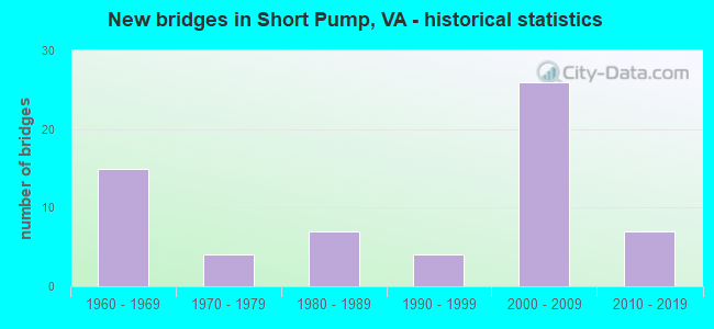
- New bridges - historical statistics
- 151960-1969
- 41970-1979
- 71980-1989
- 41990-1999
- 262000-2009
- 72010-2019


- Bridge Condition - Deck
- 3.8%Very good
- 46.2%Good
- 46.2%Satisfactory
- 3.8%Fair

- Bridge Condition - Superstructure
- 15.4%Very good
- 50.0%Good
- 26.9%Satisfactory
- 7.7%Fair

- Bridge Condition - Substructure
- 3.8%Very good
- 46.2%Good
- 30.8%Satisfactory
- 19.2%Fair

- Bridge Condition - Channel
- 3.7%Very good
- 3.7%Good
- 44.4%Satisfactory
- 40.7%Fair
- 7.4%Poor

- Bridge Condition - Culverts
- 17.6%Good
- 70.6%Satisfactory
- 5.9%Fair
- 5.9%Poor
Find on map >> Show street view
Structure Number: 8578, Location: 6.25 FR 617 & .35 TO 623 (Lat: 37.685867, Lng: -77.673494), Route carried "on" structure: Interstate 64, Year Built: 1967, Status: Open, Structure Length: 0.76m (2.49ft), Average Daily Traffic: 20,172 (year 2020), Truck Traffic: 11%, Average Future Daily Traffic: 28,241 (year 2040), Design Load: HS 20, Features Intersected: ANDERSON CREEK
Minimum Vertical Clearance: 30+ m (98+ ft), Kilometerpoint: 279.596, Lanes on structure: 2, Base Highway Network: Yes, Owner: State Highway Agency, Approaching Roadway Width: 15.8m (51.8ft), Skew: 3 degrees, Material/Design: Concrete, Design/Construction: Culvert, Number Of Spans In Main Unit: 3, Length of Maximum Span: 2.4m (7.9ft)
Condition: Channel: Fair, Culverts: Satisfactory, Operating Rating: 89.8 metric tons, Method Used To Determine Operating Rating: Field evaluation and documented engineering judgment, Inventory Rating: 89.8 metric tons, Method Used To Determine Inventory Rating: Field evaluation and documented engineering judgment, Structural Evaluation: Equal to present minimum criteria, Waterway Adequacy: Better than present minimum criteria, Approach Roadway Alignment: Equal to present desirable criteria, Designated Inspection Frequency: Every 24 months, Inspection Date: May 2021
Find on map >> Show street view
Structure Number: 8635, Location: 1.10 Fr 708 & 0.44 To 660 (Lat: 37.687861, Lng: -77.684444), Route carried "on" structure: County highway 622, Year Built: 1967, Status: Open, Structure Length: 9.42m (30.91ft), Average Daily Traffic: 2,046 (year 2020), Truck Traffic: 2%, Average Future Daily Traffic: 2,864 (year 2040), Design Load: HS 20+Mod, Features Intersected: INTERSTATE 64, Facility Carried by Structure: ROCKVILLE ROAD
Minimum Vertical Clearance: 30+ m (98+ ft), Kilometerpoint: 4.907, Lanes on structure: 2, Lanes under structure: 4, Owner: State Highway Agency, Approaching Roadway Width: 8.2m (26.9ft), Material/Design: Prestressed concrete, Design/Construction: Stringer/Multi-beam, Number Of Spans In Main Unit: 5, Length of Maximum Span: 20.3m (66.6ft), Curb or Sidewalk Widths: Left: 0.2m (0.7ft), Right: 0.2m (0.7ft), Curb-To-Curb Width: 8.1m (26.6ft), Out-to-Out Width: 9.1m (29.9ft)
Condition: Deck: Satisfactory, Superstructure: Satisfactory, Substructure: Fair, Operating Rating: 84.4 metric tons, Method Used To Determine Operating Rating: Load and Resistance Factor (LRFR), Inventory Rating: 53.5 metric tons, Method Used To Determine Inventory Rating: Load and Resistance Factor (LRFR), Structural Evaluation: Somewhat better than minimum adequacy, Deck Geometry: High priority of corrective action, Underclear: Somewhat better than minimum adequacy, Approach Roadway Alignment: Equal to present minimum criteria, Length Of Structure Improvement: 11.43m (37.50ft), Designated Inspection Frequency: Every 24 months, Inspection Date: Febuary 2022, Bridge Improvement Cost: $200,000, Roadway Improvement Cost: $25,000, Total Project Cost: $250,000 ( Estimate for 2014), Deck Structure Type: Concrete Cast-file-Place
Find on map >> Show street view
Structure Number: 8638, Location: 1.10 Fr 668 & 2.83 To 250 (Lat: 37.631936, Lng: -77.682800), Route carried "on" structure: County highway 623, Year Built: 1973, Status: Open, Structure Length: 1.65m (5.41ft), Average Daily Traffic: 2,372 (year 2020), Truck Traffic: 4%, Average Future Daily Traffic: 2,609 (year 2040), Design Load: H 20, Features Intersected: BROAD CREEK, Facility Carried by Structure: HOCKETT ROAD
Minimum Vertical Clearance: 30+ m (98+ ft), Kilometerpoint: 4.055, Lanes on structure: 2, Owner: State Highway Agency, Approaching Roadway Width: 8.5m (27.9ft), Skew: 1 degrees, Material/Design: Steel, Design/Construction: Culvert, Number Of Spans In Main Unit: 4, Length of Maximum Span: 4.0m (13.1ft)
Condition: Channel: Poor, Culverts: Poor, Operating Rating: 44.5 metric tons, Method Used To Determine Operating Rating: Field evaluation and documented engineering judgment, Inventory Rating: 32.7 metric tons, Method Used To Determine Inventory Rating: Field evaluation and documented engineering judgment, Structural Evaluation: Meets minimum limits, Waterway Adequacy: Equal to present minimum criteria, Approach Roadway Alignment: Equal to present minimum criteria, Designated Inspection Frequency: Every 12 months, Inspection Date: January 2022
Find on map >> Show street view
Structure Number: 8639, Location: .36 FR 622 & 1.89 TO 685 (Lat: 37.682750, Lng: -77.668542), Route carried "on" structure: County highway 623, Year Built: 1967, Status: Open, Structure Length: 9.39m (30.81ft), Average Daily Traffic: 10,176 (year 2020), Truck Traffic: 11%, Average Future Daily Traffic: 12,889 (year 2040), Design Load: HS 20+Mod, Features Intersected: RTE I 64, Facility Carried by Structure: ASHLAND ROAD
Minimum Vertical Clearance: 30+ m (98+ ft), Kilometerpoint: 10.330, Lanes on structure: 2, Lanes under structure: 5, Owner: State Highway Agency, Approaching Roadway Width: 13.4m (44.0ft), Skew: 1 degrees, Material/Design: Prestressed concrete, Design/Construction: Stringer/Multi-beam, Number Of Spans In Main Unit: 5, Length of Maximum Span: 21.0m (68.9ft), Curb-To-Curb Width: 10.0m (32.8ft), Out-to-Out Width: 11.0m (36.1ft)
Condition: Deck: Good, Superstructure: Satisfactory, Substructure: Satisfactory, Operating Rating: 90.1 metric tons, Method Used To Determine Operating Rating: Load and Resistance Factor (LRFR), Inventory Rating: 49.7 metric tons, Method Used To Determine Inventory Rating: Load and Resistance Factor (LRFR), Structural Evaluation: Equal to present minimum criteria, Deck Geometry: Meets minimum limits, Underclear: Somewhat better than minimum adequacy, Approach Roadway Alignment: Equal to present desirable criteria, Designated Inspection Frequency: Every 24 months, Inspection Date: October 2020, Deck Structure Type: Concrete Cast-file-Place, Wearing Surface/Protective System: Deck Protection: Epoxy Coated Reinforcing
Find on map >> Show street view
Structure Number: 868, Location: 0.60 Fr 250 & 0.11 To 622 (Lat: 37.676047, Lng: -77.676858), Route carried "on" structure: County highway 708, Year Built: 1988, Status: Open, Structure Length: 1.51m (4.95ft), Average Daily Traffic: 972 (year 2018), Average Future Daily Traffic: 1,400 (year 2040), Design Load: HS 20+Mod, Features Intersected: BRANCH OF TUCKAHOE CK, Facility Carried by Structure: SAINT MATTHEWS LN.
Minimum Vertical Clearance: 30+ m (98+ ft), Kilometerpoint: 0.965, Lanes on structure: 2, Owner: State Highway Agency, Approaching Roadway Width: 5.5m (18.0ft), Material/Design: Steel, Design/Construction: Stringer/Multi-beam, Number Of Spans In Main Unit: 1, Length of Maximum Span: 14.5m (47.6ft), Curb-To-Curb Width: 6.1m (20.0ft), Out-to-Out Width: 6.6m (21.7ft)
Condition: Deck: Good, Superstructure: Satisfactory, Substructure: Satisfactory, Channel: Satisfactory, Operating Rating: 54.7 metric tons, Method Used To Determine Operating Rating: Load Factor (LF), Inventory Rating: 32.7 metric tons, Method Used To Determine Inventory Rating: Load Factor (LF), Structural Evaluation: Equal to present minimum criteria, Deck Geometry: High priority of corrective action, Waterway Adequacy: Equal to present minimum criteria, Approach Roadway Alignment: Equal to present minimum criteria, Length Of Structure Improvement: 1.52m (4.99ft), Designated Inspection Frequency: Every 24 months, Inspection Date: Febuary 2021, Bridge Improvement Cost: $24,000, Roadway Improvement Cost: $8,000, Total Project Cost: $38,000, Deck Structure Type: Wood or Timber, Wearing Surface/Protective System: Wearing Surface: Bituminous
Find on map >> Show street view
Structure Number: 9616, Location: 0.42 TO 250 &0.19THR CH R (Lat: 37.641728, Lng: -77.585800), Route carried "on" structure: County highway 42, Year Built: 1967, Status: Open, Structure Length: 5.06m (16.60ft), Average Daily Traffic: 12,584 (year 2020), Truck Traffic: 1%, Average Future Daily Traffic: 15,216 (year 2040), Design Load: HS 20+Mod, Features Intersected: WBL ROUTE 0064, Facility Carried by Structure: COX ROAD
Minimum Vertical Clearance: 30+ m (98+ ft), Kilometerpoint: 1.303, Lanes on structure: 2, Lanes under structure: 3, Owner: State Highway Agency, Approaching Roadway Width: 8.5m (27.9ft), Skew: 1 degrees, Material/Design: Prestressed concrete, Design/Construction: Stringer/Multi-beam, Number Of Spans In Main Unit: 3, Length of Maximum Span: 19.2m (63.0ft), Curb or Sidewalk Widths: Left: 0.5m (1.6ft), Right: 1.5m (4.9ft), Curb-To-Curb Width: 8.5m (27.9ft), Out-to-Out Width: 11.1m (36.4ft)
Condition: Deck: Fair, Superstructure: Fair, Substructure: Fair, Operating Rating: 68.8 metric tons, Method Used To Determine Operating Rating: Load and Resistance Factor (LRFR), Inventory Rating: 46.6 metric tons, Method Used To Determine Inventory Rating: Load and Resistance Factor (LRFR), Structural Evaluation: Somewhat better than minimum adequacy, Deck Geometry: High priority of replacement, Underclear: Equal to present minimum criteria, Approach Roadway Alignment: Equal to present desirable criteria, Length Of Structure Improvement: 5.06m (16.60ft), Designated Inspection Frequency: Every 24 months, Inspection Date: April 2020, Bridge Improvement Cost: $600,000, Roadway Improvement Cost: $20,000, Total Project Cost: $720,000, Deck Structure Type: Concrete Cast-file-Place
Find on map >> Show street view
Structure Number: 9618, Location: 0.42 FR 250 & 0.19 TO 3CH (Lat: 37.641344, Lng: -77.586300), Route carried "on" structure: County highway 42, Year Built: 1967, Status: Open, Structure Length: 4.88m (16.01ft), Average Daily Traffic: 12,584 (year 2020), Truck Traffic: 1%, Average Future Daily Traffic: 15,216 (year 2040), Design Load: HS 20+Mod, Features Intersected: EBL ROUTE 0064, Facility Carried by Structure: COX ROAD
Minimum Vertical Clearance: 30+ m (98+ ft), Kilometerpoint: 1.223, Lanes on structure: 2, Lanes under structure: 3, Owner: State Highway Agency, Approaching Roadway Width: 8.5m (27.9ft), Material/Design: Prestressed concrete, Design/Construction: Stringer/Multi-beam, Number Of Spans In Main Unit: 3, Length of Maximum Span: 19.2m (63.0ft), Curb or Sidewalk Widths: Left: 0.5m (1.6ft), Right: 1.5m (4.9ft), Curb-To-Curb Width: 8.5m (27.9ft), Out-to-Out Width: 11.1m (36.4ft)
Condition: Deck: Satisfactory, Superstructure: Fair, Substructure: Fair, Operating Rating: 70.0 metric tons, Method Used To Determine Operating Rating: Load and Resistance Factor (LRFR), Inventory Rating: 45.8 metric tons, Method Used To Determine Inventory Rating: Load and Resistance Factor (LRFR), Structural Evaluation: Somewhat better than minimum adequacy, Deck Geometry: High priority of replacement, Underclear: Somewhat better than minimum adequacy, Approach Roadway Alignment: Equal to present desirable criteria, Length Of Structure Improvement: 4.88m (16.01ft), Designated Inspection Frequency: Every 24 months, Inspection Date: April 2020, Bridge Improvement Cost: $600,000, Roadway Improvement Cost: $20,000, Total Project Cost: $720,000, Deck Structure Type: Concrete Cast-file-Place
Find on map >> Show street view
Structure Number: 9686, Location: .2 Fr Sadler&.43 To F-318 (Lat: 37.671092, Lng: -77.581761), Route carried "on" structure: County highway 7706, Year Built: 1980, Status: Open, Structure Length: 15.10m (49.54ft), Average Daily Traffic: 15,538 (year 2020), Average Future Daily Traffic: 21,755 (year 2040), Design Load: HS 20+Mod, Features Intersected: ROUTE 0295, Facility Carried by Structure: NUCKOLS ROAD SBL
Minimum Vertical Clearance: 30+ m (98+ ft), Kilometerpoint: 5.519, Lanes on structure: 3, Lanes under structure: 8, Owner: State Highway Agency, Approaching Roadway Width: 16.2m (53.1ft), Skew: 1 degrees, Material/Design: Steel continuous, Design/Construction: Stringer/Multi-beam, Number Of Spans In Main Unit: 3, Number Of Approach Spans: 2, Length of Maximum Span: 49.7m (163.1ft), Curb-To-Curb Width: 15.4m (50.5ft), Out-to-Out Width: 16.4m (53.8ft)
Condition: Deck: Satisfactory, Superstructure: Satisfactory, Substructure: Fair, Operating Rating: 68.9 metric tons, Method Used To Determine Operating Rating: Load and Resistance Factor (LRFR), Inventory Rating: 53.5 metric tons, Method Used To Determine Inventory Rating: Load and Resistance Factor (LRFR), Structural Evaluation: Somewhat better than minimum adequacy, Deck Geometry: Equal to present minimum criteria, Underclear: Better than present minimum criteria, Approach Roadway Alignment: Equal to present desirable criteria, Designated Inspection Frequency: Every 24 months, Inspection Date: July 2021, Deck Structure Type: Concrete Cast-file-Place, Wearing Surface/Protective System: Deck Protection: Epoxy Coated Reinforcing
Find on map >> Show street view
Structure Number: 9692, Location: 0.92 TO GASKINS ROAD (Lat: 37.625333, Lng: -77.599500), Route carried "on" structure: County highway , Year Built: 1987, Status: Open, Structure Length: 1.62m (5.31ft), Average Daily Traffic: 12,031 (year 2020), Truck Traffic: 1%, Average Future Daily Traffic: 15,289 (year 2040), Design Load: HS 20+Mod, Features Intersected: STONEY RUN, Facility Carried by Structure: RIDGEFIELD PARKWAY
Minimum Vertical Clearance: 30+ m (98+ ft), Kilometerpoint: 0.000, Lanes on structure: 4, Owner: County Highway Agency, Approaching Roadway Width: 16.2m (53.1ft), Skew: 3 degrees, Material/Design: Concrete, Design/Construction: Culvert, Number Of Spans In Main Unit: 4, Length of Maximum Span: 4.0m (13.1ft)
Condition: Channel: Satisfactory, Culverts: Satisfactory, Operating Rating: 54.4 metric tons, Method Used To Determine Operating Rating: Load Factor (LF), Inventory Rating: 32.7 metric tons, Method Used To Determine Inventory Rating: Load Factor (LF), Structural Evaluation: Equal to present minimum criteria, Waterway Adequacy: Equal to present desirable criteria, Approach Roadway Alignment: Equal to present desirable criteria, Designated Inspection Frequency: Every 24 months, Inspection Date: January 2022
Find on map >> Show street view
Structure Number: 9693, Location: 0.88 TO GASKINS ROAD (Lat: 37.625378, Lng: -77.598917), Route carried "on" structure: County highway , Year Built: 1987, Status: Open, Structure Length: 0.67m (2.20ft), Average Daily Traffic: 12,031 (year 2020), Truck Traffic: 1%, Average Future Daily Traffic: 15,289 (year 2040), Design Load: HS 20+Mod, Features Intersected: STREAM TO STONEY RUN, Facility Carried by Structure: RIDGEFIELD PARKWAY
Minimum Vertical Clearance: 30+ m (98+ ft), Kilometerpoint: 0.000, Lanes on structure: 4, Owner: County Highway Agency, Approaching Roadway Width: 16.2m (53.1ft), Skew: 2 degrees, Material/Design: Concrete, Design/Construction: Culvert, Number Of Spans In Main Unit: 2, Length of Maximum Span: 3.4m (11.2ft)
Condition: Channel: Satisfactory, Culverts: Satisfactory, Operating Rating: 54.4 metric tons, Method Used To Determine Operating Rating: Load Factor (LF), Inventory Rating: 32.7 metric tons, Method Used To Determine Inventory Rating: Load Factor (LF), Structural Evaluation: Equal to present minimum criteria, Waterway Adequacy: Equal to present desirable criteria, Approach Roadway Alignment: Equal to present desirable criteria, Designated Inspection Frequency: Every 24 months, Inspection Date: January 2022
Find on map >> Show street view
Structure Number: 9778, Location: 0.17GOOCH CO 2.17I 295 EB (Lat: 37.667300, Lng: -77.641981), Route carried "on" structure: Interstate 64, Year Built: 1968, Status: Open, Structure Length: 1.04m (3.41ft), Average Daily Traffic: 30,870 (year 2020), Truck Traffic: 11%, Average Future Daily Traffic: 43,218 (year 2040), Design Load: HS 20, Features Intersected: UNNAMED TRIBUTARY
Minimum Vertical Clearance: 30+ m (98+ ft), Kilometerpoint: 282.975, Lanes on structure: 2, Base Highway Network: Yes, Owner: State Highway Agency, Approaching Roadway Width: 13.4m (44.0ft), Material/Design: Concrete, Design/Construction: Culvert, Number Of Spans In Main Unit: 4, Length of Maximum Span: 2.4m (7.9ft)
Condition: Channel: Fair, Culverts: Satisfactory, Operating Rating: 89.8 metric tons, Method Used To Determine Operating Rating: Field evaluation and documented engineering judgment, Inventory Rating: 89.8 metric tons, Method Used To Determine Inventory Rating: Field evaluation and documented engineering judgment, Structural Evaluation: Equal to present minimum criteria, Waterway Adequacy: Equal to present desirable criteria, Approach Roadway Alignment: Equal to present desirable criteria, Designated Inspection Frequency: Every 24 months, Inspection Date: December 2021
Find on map >> Show street view
Structure Number: 9779, Location: 0.17GOOCH CO 2.17I 295 WB (Lat: 37.667842, Lng: -77.641583), Route carried "on" structure: Interstate 64, Year Built: 1968, Status: Open, Structure Length: 1.04m (3.41ft), Average Daily Traffic: 30,899 (year 2020), Truck Traffic: 11%, Average Future Daily Traffic: 43,259 (year 2040), Design Load: HS 20, Features Intersected: UNNAMED TRIBUTARY
Minimum Vertical Clearance: 30+ m (98+ ft), Kilometerpoint: 283.007, Lanes on structure: 2, Base Highway Network: Yes, Owner: State Highway Agency, Approaching Roadway Width: 13.4m (44.0ft), Material/Design: Concrete, Design/Construction: Culvert, Number Of Spans In Main Unit: 4, Length of Maximum Span: 2.4m (7.9ft)
Condition: Channel: Fair, Culverts: Satisfactory, Operating Rating: 89.8 metric tons, Method Used To Determine Operating Rating: Field evaluation and documented engineering judgment, Inventory Rating: 89.8 metric tons, Method Used To Determine Inventory Rating: Field evaluation and documented engineering judgment, Structural Evaluation: Equal to present minimum criteria, Waterway Adequacy: Equal to present desirable criteria, Approach Roadway Alignment: Equal to present desirable criteria, Designated Inspection Frequency: Every 24 months, Inspection Date: December 2021
Find on map >> Show street view
Structure Number: 978, Location: 0.80GOOCH CO 1.54I 295 WB (Lat: 37.663250, Lng: -77.631892), Route carried "on" structure: Interstate 64, Year Built: 1968, Status: Open, Structure Length: 0.64m (2.10ft), Average Daily Traffic: 30,870 (year 2020), Truck Traffic: 10%, Average Future Daily Traffic: 43,218 (year 2040), Design Load: HS 20, Features Intersected: MILLS CREEK
Minimum Vertical Clearance: 30+ m (98+ ft), Kilometerpoint: 283.989, Lanes on structure: 2, Base Highway Network: Yes, Owner: State Highway Agency, Approaching Roadway Width: 22.6m (74.1ft), Skew: 2 degrees, Material/Design: Concrete, Design/Construction: Culvert, Number Of Spans In Main Unit: 3, Length of Maximum Span: 2.1m (6.9ft)
Condition: Channel: Fair, Culverts: Satisfactory, Operating Rating: 89.8 metric tons, Method Used To Determine Operating Rating: Field evaluation and documented engineering judgment, Inventory Rating: 89.8 metric tons, Method Used To Determine Inventory Rating: Field evaluation and documented engineering judgment, Structural Evaluation: Equal to present minimum criteria, Waterway Adequacy: Equal to present desirable criteria, Approach Roadway Alignment: Equal to present desirable criteria, Designated Inspection Frequency: Every 24 months, Inspection Date: December 2021
Find on map >> Show street view
Structure Number: 9781, Location: 0.82GOOCH CO 1.52I 295 WB (Lat: 37.663667, Lng: -77.631358), Route carried "on" structure: Interstate 64, Year Built: 1968, Status: Open, Structure Length: 0.64m (2.10ft), Average Daily Traffic: 30,899 (year 2020), Truck Traffic: 11%, Average Future Daily Traffic: 43,259 (year 2040), Design Load: HS 20, Features Intersected: MILLS CREEK
Minimum Vertical Clearance: 30+ m (98+ ft), Kilometerpoint: 284.053, Lanes on structure: 3, Base Highway Network: Yes, Owner: State Highway Agency, Approaching Roadway Width: 13.4m (44.0ft), Skew: 2 degrees, Material/Design: Concrete, Design/Construction: Culvert, Number Of Spans In Main Unit: 3, Length of Maximum Span: 2.1m (6.9ft)
Condition: Channel: Fair, Culverts: Satisfactory, Operating Rating: 89.8 metric tons, Method Used To Determine Operating Rating: Field evaluation and documented engineering judgment, Inventory Rating: 89.8 metric tons, Method Used To Determine Inventory Rating: Field evaluation and documented engineering judgment, Structural Evaluation: Equal to present minimum criteria, Waterway Adequacy: Equal to present desirable criteria, Approach Roadway Alignment: Equal to present desirable criteria, Designated Inspection Frequency: Every 24 months, Inspection Date: December 2021
Find on map >> Show street view
Structure Number: 9792, Location: .77fr295 / 2.83toRte 73 (Lat: 37.648633, Lng: -77.594389), Route carried "on" structure: Interstate 64, Year Built: 1967, Status: Open, Structure Length: 9.45m (31.00ft), Average Daily Traffic: 34,415 (year 2020), Truck Traffic: 3%, Average Future Daily Traffic: 48,181 (year 2040), Design Load: HS 20+Mod, Features Intersected: RTE 250
Minimum Vertical Clearance: 30+ m (98+ ft), Kilometerpoint: 287.754, Lanes on structure: 4, Lanes under structure: 7, Base Highway Network: Yes, Owner: State Highway Agency, Approaching Roadway Width: 21.9m (71.9ft), Skew: 4 degrees, Material/Design: Steel, Design/Construction: Stringer/Multi-beam, Number Of Spans In Main Unit: 4, Length of Maximum Span: 25.9m (85.0ft), Curb-To-Curb Width: 21.9m (71.9ft), Out-to-Out Width: 23.0m (75.5ft)
Condition: Deck: Good, Superstructure: Satisfactory, Substructure: Fair, Operating Rating: 89.4 metric tons, Method Used To Determine Operating Rating: Load and Resistance Factor (LRFR), Inventory Rating: 69.0 metric tons, Method Used To Determine Inventory Rating: Load and Resistance Factor (LRFR), Structural Evaluation: Somewhat better than minimum adequacy, Deck Geometry: Better than present minimum criteria, Underclear: Equal to present minimum criteria, Approach Roadway Alignment: Equal to present desirable criteria, Length Of Structure Improvement: 10.67m (35.01ft), Designated Inspection Frequency: Every 24 months, Inspection Date: March 2021, Bridge Improvement Cost: $200,000, Roadway Improvement Cost: $50,000, Total Project Cost: $255,000, Deck Structure Type: Concrete Cast-file-Place, Wearing Surface/Protective System: Deck Protection: Epoxy Coated Reinforcing
Find on map >> Show street view
Structure Number: 9915, Location: 0.0 TO 64 & 1.74 TO NUCKO (Lat: 37.655208, Lng: -77.605667), Route carried "on" structure: Interstate 295, Year Built: 1980, Status: Open, Structure Length: 10.24m (33.60ft), Average Daily Traffic: 11,846 (year 2020), Truck Traffic: 6%, Average Future Daily Traffic: 16,584 (year 2040), Design Load: HS 20+Mod, Features Intersected: ROUTE I-64
Minimum Vertical Clearance: 30+ m (98+ ft), Kilometerpoint: 0.016, Lanes on structure: 1, Lanes under structure: 7, Base Highway Network: Yes, Owner: State Highway Agency, Approaching Roadway Width: 22.3m (73.2ft), Material/Design: Steel continuous, Design/Construction: Stringer/Multi-beam, Number Of Spans In Main Unit: 2, Number Of Approach Spans: 2, Length of Maximum Span: 37.8m (124.0ft), Curb-To-Curb Width: 21.5m (70.5ft), Out-to-Out Width: 22.5m (73.8ft)
Condition: Deck: Satisfactory, Superstructure: Satisfactory, Substructure: Satisfactory, Operating Rating: 73.8 metric tons, Method Used To Determine Operating Rating: Load and Resistance Factor (LRFR), Inventory Rating: 57.0 metric tons, Method Used To Determine Inventory Rating: Load and Resistance Factor (LRFR), Structural Evaluation: Equal to present minimum criteria, Deck Geometry: Superior to present desirable criteria, Underclear: Equal to present minimum criteria, Approach Roadway Alignment: Equal to present desirable criteria, Designated Inspection Frequency: Every 24 months, Inspection Date: November 2020, Deck Structure Type: Concrete Cast-file-Place, Wearing Surface/Protective System: Wearing Surface: Epoxy Overlay, Deck Protection: Epoxy Coated Reinforcing
Find on map >> Show street view
Structure Number: 9933, Location: .81 TO 64 & .89 TO NUCKOL (Lat: 37.664858, Lng: -77.595300), Route carried "on" structure: Interstate 295, Year Built: 1979, Status: Open, Structure Length: 0.79m (2.59ft), Average Daily Traffic: 24,609 (year 2020), Truck Traffic: 6%, Average Future Daily Traffic: 34,453 (year 2040), Design Load: HS 20+Mod, Features Intersected: ALLENS BRANCH
Minimum Vertical Clearance: 30+ m (98+ ft), Kilometerpoint: 1.368, Lanes on structure: 3, Base Highway Network: Yes, Owner: State Highway Agency, Approaching Roadway Width: 18.3m (60.0ft), Skew: 3 degrees, Material/Design: Concrete, Design/Construction: Culvert, Number Of Spans In Main Unit: 3, Length of Maximum Span: 2.4m (7.9ft)
Condition: Channel: Satisfactory, Culverts: Satisfactory, Structural Evaluation: Equal to present minimum criteria, Waterway Adequacy: Equal to present minimum criteria, Approach Roadway Alignment: Equal to present desirable criteria, Designated Inspection Frequency: Every 24 months, Inspection Date: October 2021
Find on map >> Show street view
Structure Number: 9936, Location: .05 TO 295 & .30 TO NUCKO (Lat: 37.670567, Lng: -77.583886), Route carried "on" structure: Ramp Interstate 295, Year Built: 1979, Status: Open, Structure Length: 1.46m (4.79ft), Average Daily Traffic: 4,681 (year 2020), Average Future Daily Traffic: 5,958 (year 2040), Design Load: HS 20+Mod, Features Intersected: ALLENS BRANCH
Minimum Vertical Clearance: 30+ m (98+ ft), Kilometerpoint: 0.000, Lanes on structure: 1, Base Highway Network: Yes, Owner: State Highway Agency, Approaching Roadway Width: 9.8m (32.2ft), Skew: 3 degrees, Material/Design: Concrete, Design/Construction: Culvert, Number Of Spans In Main Unit: 4, Length of Maximum Span: 3.5m (11.5ft)
Condition: Channel: Fair, Culverts: Fair, Operating Rating: 54.4 metric tons, Method Used To Determine Operating Rating: Field evaluation and documented engineering judgment, Inventory Rating: 32.7 metric tons, Method Used To Determine Inventory Rating: Field evaluation and documented engineering judgment, Structural Evaluation: Somewhat better than minimum adequacy, Waterway Adequacy: Equal to present minimum criteria, Approach Roadway Alignment: Equal to present desirable criteria, Designated Inspection Frequency: Every 24 months, Inspection Date: November 2021
Find on map >> Show street view
Structure Number: 9945, Location: 0.3 NUCKOLS & 0.1 I-295 W (Lat: 37.669711, Lng: -77.586569), Route carried "on" structure: Ramp Interstate 295, Year Built: 1979, Status: Open, Structure Length: 1.55m (5.09ft), Average Daily Traffic: 5,315 (year 2020), Truck Traffic: 1%, Average Future Daily Traffic: 7,441 (year 2040), Design Load: HS 20+Mod, Features Intersected: ALLEN BRANCH
Minimum Vertical Clearance: 30+ m (98+ ft), Kilometerpoint: 0.000, Lanes on structure: 1, Base Highway Network: Yes, Owner: State Highway Agency, Approaching Roadway Width: 9.8m (32.2ft), Skew: 3 degrees, Material/Design: Concrete, Design/Construction: Culvert, Number Of Spans In Main Unit: 4, Length of Maximum Span: 3.7m (12.1ft)
Condition: Channel: Poor, Culverts: Satisfactory, Operating Rating: 54.4 metric tons, Method Used To Determine Operating Rating: Field evaluation and documented engineering judgment, Inventory Rating: 32.7 metric tons, Method Used To Determine Inventory Rating: Field evaluation and documented engineering judgment, Structural Evaluation: Equal to present minimum criteria, Waterway Adequacy: Equal to present desirable criteria, Approach Roadway Alignment: Equal to present desirable criteria, Designated Inspection Frequency: Every 24 months, Inspection Date: September 2021
Find on map >> Show street view
Structure Number: 25225, Location: 2.75W. Crk Pkw 1.08To250 (Lat: 37.651511, Lng: -77.664611), Route carried "on" structure: State highway 288, Year Built: 1997, Status: Open, Structure Length: 1.07m (3.51ft), Average Daily Traffic: 39,673 (year 2020), Truck Traffic: 3%, Average Future Daily Traffic: 55,542 (year 2040), Design Load: HS 20+Mod, Features Intersected: WET WEATHER STREAM
Minimum Vertical Clearance: 30+ m (98+ ft), Kilometerpoint: 31.134, Lanes on structure: 5, Base Highway Network: Yes, Owner: State Highway Agency, Approaching Roadway Width: 29.0m (95.1ft), Skew: 21 degrees, Material/Design: Concrete, Design/Construction: Culvert, Number Of Spans In Main Unit: 4, Length of Maximum Span: 2.4m (7.9ft)
Condition: Channel: Fair, Culverts: Satisfactory, Operating Rating: 89.8 metric tons, Method Used To Determine Operating Rating: Field evaluation and documented engineering judgment, Inventory Rating: 89.8 metric tons, Method Used To Determine Inventory Rating: Field evaluation and documented engineering judgment, Structural Evaluation: Equal to present minimum criteria, Waterway Adequacy: Equal to present desirable criteria, Approach Roadway Alignment: Equal to present desirable criteria, Designated Inspection Frequency: Every 24 months, Inspection Date: March 2020
Find on map >> Show street view
Structure Number: 25228, Location: 3.14 West Ck Pkw .69To250 (Lat: 37.656808, Lng: -77.662508), Route carried "on" structure: State highway 288, Year Built: 1997, Year Reconstructed: 2003, Status: Open, Structure Length: 15.97m (52.40ft), Average Daily Traffic: 19,836 (year 2020), Truck Traffic: 3%, Average Future Daily Traffic: 27,772 (year 2040), Design Load: HS 20+Mod, Features Intersected: TUCKAHOE CREEK
Minimum Vertical Clearance: 30+ m (98+ ft), Kilometerpoint: 31.762, Lanes on structure: 3, Base Highway Network: Yes, Owner: State Highway Agency, Approaching Roadway Width: 18.0m (59.1ft), Skew: 2 degrees, Material/Design: Prestressed concrete continuous, Design/Construction: Stringer/Multi-beam, Number Of Spans In Main Unit: 7, Length of Maximum Span: 22.9m (75.1ft), Curb or Sidewalk Widths: Left: 0.2m (0.7ft), Right: 0.2m (0.7ft), Curb-To-Curb Width: 18.0m (59.1ft), Out-to-Out Width: 19.0m (62.3ft)
Condition: Deck: Satisfactory, Superstructure: Good, Substructure: Good, Channel: Satisfactory, Operating Rating: 62.1 metric tons, Method Used To Determine Operating Rating: Load and Resistance Factor (LRFR), Inventory Rating: 48.0 metric tons, Method Used To Determine Inventory Rating: Load and Resistance Factor (LRFR), Structural Evaluation: Better than present minimum criteria, Deck Geometry: Superior to present desirable criteria, Waterway Adequacy: Equal to present desirable criteria, Approach Roadway Alignment: Equal to present desirable criteria, Designated Inspection Frequency: Every 24 months, Inspection Date: Febuary 2022, Deck Structure Type: Concrete Cast-file-Place, Wearing Surface/Protective System: Deck Protection: Epoxy Coated Reinforcing
Find on map >> Show street view
Structure Number: 25387, Location: .57 fr CL & .31 to Gayton (Lat: 37.660308, Lng: -77.638214), Route carried "on" structure: US 250, Year Built: 1999, Status: Open, Structure Length: 1.10m (3.61ft), Average Daily Traffic: 26,292 (year 2020), Average Future Daily Traffic: 36,809 (year 2040), Design Load: HS 20+Mod, Features Intersected: Mills Creek, Facility Carried by Structure: Broad Street
Minimum Vertical Clearance: 30+ m (98+ ft), Kilometerpoint: 243.934, Lanes on structure: 6, Base Highway Network: Yes, Owner: State Highway Agency, Approaching Roadway Width: 23.2m (76.1ft), Skew: 14 degrees, Material/Design: Concrete, Design/Construction: Culvert, Number Of Spans In Main Unit: 3, Length of Maximum Span: 3.4m (11.2ft)
Condition: Channel: Fair, Culverts: Satisfactory, Operating Rating: 44.5 metric tons, Method Used To Determine Operating Rating: Load Factor (LF), Inventory Rating: 32.7 metric tons, Method Used To Determine Inventory Rating: Load Factor (LF), Structural Evaluation: Equal to present minimum criteria, Waterway Adequacy: Better than present minimum criteria, Approach Roadway Alignment: Equal to present desirable criteria, Designated Inspection Frequency: Every 24 months, Inspection Date: December 2021
Find on map >> Show street view
Structure Number: 2628, Location: .18 Fr 288&0.10 To Hen CL (Lat: 37.662456, Lng: -77.648131), Route carried "on" structure: US 250, Year Built: 1999, Status: Open, Structure Length: 1.62m (5.31ft), Average Daily Traffic: 31,462 (year 2020), Truck Traffic: 3%, Average Future Daily Traffic: 44,047 (year 2040), Design Load: HS 20+Mod, Features Intersected: LITTLE TUCKAHOE CREEK, Facility Carried by Structure: BROAD STREET ROAD
Minimum Vertical Clearance: 30+ m (98+ ft), Kilometerpoint: 242.846, Lanes on structure: 9, Base Highway Network: Yes, Owner: State Highway Agency, Approaching Roadway Width: 34.7m (113.8ft), Skew: 20 degrees, Material/Design: Prestressed concrete, Design/Construction: Stringer/Multi-beam, Number Of Spans In Main Unit: 1, Length of Maximum Span: 14.8m (48.6ft), Curb or Sidewalk Widths: Left: 2.3m (7.5ft), Right: 2.3m (7.5ft), Curb-To-Curb Width: 36.0m (118.1ft), Out-to-Out Width: 41.4m (135.8ft)
Condition: Deck: Satisfactory, Superstructure: Very good, Substructure: Good, Channel: Fair, Operating Rating: 89.8 metric tons, Method Used To Determine Operating Rating: Load and Resistance Factor (LRFR), Inventory Rating: 68.9 metric tons, Method Used To Determine Inventory Rating: Load and Resistance Factor (LRFR), Structural Evaluation: Better than present minimum criteria, Deck Geometry: Somewhat better than minimum adequacy, Waterway Adequacy: Equal to present minimum criteria, Approach Roadway Alignment: Equal to present desirable criteria, Designated Inspection Frequency: Every 24 months, Inspection Date: March 2020, Deck Structure Type: Concrete Cast-file-Place, Wearing Surface/Protective System: Deck Protection: Epoxy Coated Reinforcing
Find on map >> Show street view
Structure Number: 26461, Location: 0.10 288 NBL 0.30 64 WBL (Lat: 37.672011, Lng: -77.650819), Route carried "on" structure: Ramp State highway 288, Year Built: 2003, Status: Open, Structure Length: 15.39m (50.49ft), Average Daily Traffic: 5,876 (year 2020), Truck Traffic: 13%, Average Future Daily Traffic: 8,226 (year 2040), Design Load: HS 20+Mod, Features Intersected: I-64 & RAMP H FR 64 WBL
Minimum Vertical Clearance: 5.82m (19.09ft), Kilometerpoint: 0.016, Lanes on structure: 2, Lanes under structure: 12, Base Highway Network: Yes, Owner: State Highway Agency, Approaching Roadway Width: 13.4m (44.0ft), Material/Design: Steel continuous, Design/Construction: Stringer/Multi-beam, Number Of Spans In Main Unit: 2, Length of Maximum Span: 75.9m (249.0ft), Curb or Sidewalk Widths: Left: 0.2m (0.7ft), Right: 0.2m (0.7ft), Curb-To-Curb Width: 13.5m (44.3ft), Out-to-Out Width: 14.5m (47.6ft)
Condition: Deck: Good, Superstructure: Good, Substructure: Good, Operating Rating: 76.2 metric tons, Method Used To Determine Operating Rating: Load and Resistance Factor (LRFR), Inventory Rating: 59.0 metric tons, Method Used To Determine Inventory Rating: Load and Resistance Factor (LRFR), Structural Evaluation: Better than present minimum criteria, Deck Geometry: Superior to present desirable criteria, Underclear: Better than present minimum criteria, Approach Roadway Alignment: Equal to present minimum criteria, Designated Inspection Frequency: Every 24 months, Inspection Date: January 2022, Deck Structure Type: Concrete Cast-file-Place, Wearing Surface/Protective System: Deck Protection: Epoxy Coated Reinforcing
Find on map >> Show street view
Structure Number: 26462, Location: 0.05 64 WBL 0.40 288 SBL (Lat: 37.672594, Lng: -77.648494), Route carried "on" structure: Ramp Interstate 64, Year Built: 2003, Status: Open, Structure Length: 20.45m (67.09ft), Average Daily Traffic: 23,380 (year 2020), Truck Traffic: 1%, Average Future Daily Traffic: 28,992 (year 2040), Design Load: HS 20+Mod, Features Intersected: RTE 64 & LIT TUCKAHOE CK
Minimum Vertical Clearance: 5.28m (17.32ft), Kilometerpoint: 0.467, Lanes on structure: 2, Lanes under structure: 4, Base Highway Network: Yes, Owner: State Highway Agency, Approaching Roadway Width: 13.4m (44.0ft), Material/Design: Steel continuous, Design/Construction: Stringer/Multi-beam, Number Of Spans In Main Unit: 3, Length of Maximum Span: 75.0m (246.1ft), Curb-To-Curb Width: 13.5m (44.3ft), Out-to-Out Width: 14.5m (47.6ft)
Condition: Deck: Satisfactory, Superstructure: Good, Substructure: Good, Channel: Very good, Operating Rating: 79.8 metric tons, Method Used To Determine Operating Rating: Load and Resistance Factor (LRFR), Inventory Rating: 61.7 metric tons, Method Used To Determine Inventory Rating: Load and Resistance Factor (LRFR), Structural Evaluation: Better than present minimum criteria, Deck Geometry: Superior to present desirable criteria, Underclear: Somewhat better than minimum adequacy, Waterway Adequacy: Equal to present desirable criteria, Approach Roadway Alignment: Equal to present minimum criteria, Designated Inspection Frequency: Every 24 months, Inspection Date: January 2022, Deck Structure Type: Concrete Cast-file-Place, Wearing Surface/Protective System: Deck Protection: Epoxy Coated Reinforcing
Find on map >> Show street view
Structure Number: 26463, Location: 0.10 288 NBL 0.10 64 EBL (Lat: 37.669917, Lng: -77.649861), Route carried "on" structure: Ramp State highway 288, Year Built: 2003, Status: Open, Structure Length: 21.00m (68.90ft), Average Daily Traffic: 11,304 (year 2020), Truck Traffic: 3%, Average Future Daily Traffic: 15,183 (year 2040), Design Load: HS 20+Mod, Features Intersected: LITTLE TUCKAHOE CREEK
Minimum Vertical Clearance: 30+ m (98+ ft), Kilometerpoint: 0.193, Lanes on structure: 2, Base Highway Network: Yes, Owner: State Highway Agency, Approaching Roadway Width: 13.4m (44.0ft), Material/Design: Steel continuous, Design/Construction: Stringer/Multi-beam, Number Of Spans In Main Unit: 4, Length of Maximum Span: 57.9m (190.0ft), Curb-To-Curb Width: 13.5m (44.3ft), Out-to-Out Width: 14.5m (47.6ft)
Condition: Deck: Satisfactory, Superstructure: Good, Substructure: Good, Channel: Satisfactory, Operating Rating: 73.8 metric tons, Method Used To Determine Operating Rating: Load Factor (LF), Inventory Rating: 44.5 metric tons, Method Used To Determine Inventory Rating: Load Factor (LF), Structural Evaluation: Better than present minimum criteria, Deck Geometry: Superior to present desirable criteria, Waterway Adequacy: Equal to present desirable criteria, Approach Roadway Alignment: Equal to present minimum criteria, Designated Inspection Frequency: Every 24 months, Inspection Date: January 2022, Deck Structure Type: Concrete Cast-file-Place, Wearing Surface/Protective System: Deck Protection: Epoxy Coated Reinforcing
Find on map >> Show street view
Structure Number: 26664, Location: .20Fr 623 .20To Cap One (Lat: 37.637208, Lng: -77.674856), Route carried "on" structure: County highway 740, Year Built: 2003, Status: Open, Structure Length: 0.83m (2.72ft), Average Daily Traffic: 1,000 (year 2003), Truck Traffic: 2%, Average Future Daily Traffic: 1,400 (year 2025), Design Load: H 20, Features Intersected: UNNAMED TRIBUTARY, Facility Carried by Structure: TUCKAHOE CRK PARKW
Minimum Vertical Clearance: 30+ m (98+ ft), Kilometerpoint: 0.000, Lanes on structure: 4, Owner: State Highway Agency, Approaching Roadway Width: 14.6m (47.9ft), Skew: 13 degrees, Material/Design: Concrete, Design/Construction: Culvert, Number Of Spans In Main Unit: 3, Length of Maximum Span: 1.8m (5.9ft)
Condition: Channel: Satisfactory, Culverts: Satisfactory, Operating Rating: 44.5 metric tons, Method Used To Determine Operating Rating: Field evaluation and documented engineering judgment, Inventory Rating: 32.7 metric tons, Method Used To Determine Inventory Rating: Field evaluation and documented engineering judgment, Structural Evaluation: Equal to present minimum criteria, Waterway Adequacy: Equal to present desirable criteria, Approach Roadway Alignment: Equal to present desirable criteria, Designated Inspection Frequency: Every 24 months, Inspection Date: May 2020
Find on map >> Show street view
Structure Number: 26671, Location: 0.41 FR 250 & 0.64 KAIN (Lat: 37.657033, Lng: -77.611739), Route carried "on" structure: State highway 271, Year Built: 2008, Status: Open, Structure Length: 10.39m (34.09ft), Average Daily Traffic: 9,322 (year 2020), Truck Traffic: 2%, Average Future Daily Traffic: 10,487 (year 2040), Design Load: HS 20+Mod, Features Intersected: ROUTE I-64, Facility Carried by Structure: POUNCEY TRACT ROAD
Minimum Vertical Clearance: 30+ m (98+ ft), Kilometerpoint: 0.660, Lanes on structure: 4, Lanes under structure: 10, Owner: State Highway Agency, Approaching Roadway Width: 16.2m (53.1ft), Skew: 23 degrees, Material/Design: Steel continuous, Design/Construction: Stringer/Multi-beam, Number Of Spans In Main Unit: 2, Length of Maximum Span: 52.5m (172.2ft), Curb or Sidewalk Widths: Left: 1.6m (5.2ft), Right: 1.6m (5.2ft), Curb-To-Curb Width: 16.2m (53.1ft), Out-to-Out Width: 25.1m (82.3ft)
Condition: Deck: Good, Superstructure: Good, Substructure: Good, Operating Rating: 87.1 metric tons, Method Used To Determine Operating Rating: Load and Resistance Factor (LRFR), Inventory Rating: 67.2 metric tons, Method Used To Determine Inventory Rating: Load and Resistance Factor (LRFR), Structural Evaluation: Better than present minimum criteria, Deck Geometry: Meets minimum limits, Underclear: Equal to present minimum criteria, Approach Roadway Alignment: Equal to present desirable criteria, Length Of Structure Improvement: 9.20m (30.18ft), Designated Inspection Frequency: Every 24 months, Inspection Date: August 2021, Bridge Improvement Cost: $800,000, Roadway Improvement Cost: $50,000, Total Project Cost: $900,000, Deck Structure Type: Concrete Cast-file-Place, Wearing Surface/Protective System: Wearing Surface: Epoxy Overlay, Deck Protection: Epoxy Coated Reinforcing
Find on map >> Show street view
Structure Number: 26672, Location: 0.15 64 EBL 0.33 295 EBL (Lat: 37.656164, Lng: -77.608314), Route carried "on" structure: Ramp Interstate 64, Year Built: 2009, Status: Open, Structure Length: 53.80m (176.51ft), Average Daily Traffic: 13,466 (year 2020), Truck Traffic: 9%, Average Future Daily Traffic: 18,852 (year 2040), Design Load: HS 20+Mod, Features Intersected: RTES I-64 AND I-295 WBL, Facility Carried by Structure: FLYOVER TO 295 EBL
Minimum Vertical Clearance: 30+ m (98+ ft), Kilometerpoint: 0.000, Lanes on structure: 2, Lanes under structure: 7, Base Highway Network: Yes, Owner: State Highway Agency, Approaching Roadway Width: 12.6m (41.3ft), Material/Design: Steel continuous, Design/Construction: Stringer/Multi-beam, Number Of Spans In Main Unit: 11, Length of Maximum Span: 59.1m (193.9ft), Curb-To-Curb Width: 12.6m (41.3ft), Out-to-Out Width: 13.6m (44.6ft)
Condition: Deck: Good, Superstructure: Good, Substructure: Good, Operating Rating: 60.8 metric tons, Method Used To Determine Operating Rating: Load Factor (LF), Inventory Rating: 37.2 metric tons, Method Used To Determine Inventory Rating: Load Factor (LF), Structural Evaluation: Better than present minimum criteria, Deck Geometry: Superior to present desirable criteria, Underclear: Somewhat better than minimum adequacy, Approach Roadway Alignment: Equal to present minimum criteria, Designated Inspection Frequency: Every 24 months, Critical Feature Inspection Frequency: Every 12 months, Inspection Date: March 2021, Critical Feature Inspection Date: March 2021, Deck Structure Type: Concrete Cast-file-Place, Wearing Surface/Protective System: Deck Protection: Epoxy Coated Reinforcing
Find on map >> Show street view
Structure Number: 26796, Location: .35 Fr 1010 & .11 To 1001 (Lat: 37.666194, Lng: -77.664900), Route carried "on" structure: US 250, Year Built: 2003, Status: Open, Structure Length: 2.35m (7.71ft), Average Daily Traffic: 14,252 (year 2020), Truck Traffic: 3%, Average Future Daily Traffic: 19,953 (year 2040), Design Load: HS 20+Mod, Features Intersected: TUCKAHOE CREEK, Facility Carried by Structure: BROAD STREET RD
Minimum Vertical Clearance: 30+ m (98+ ft), Kilometerpoint: 241.463, Lanes on structure: 6, Owner: State Highway Agency, Approaching Roadway Width: 23.5m (77.1ft), Skew: 24 degrees, Material/Design: Prestressed concrete, Design/Construction: Stringer/Multi-beam, Number Of Spans In Main Unit: 1, Length of Maximum Span: 21.6m (70.9ft), Curb or Sidewalk Widths: Left: 2.3m (7.5ft), Right: 2.3m (7.5ft), Curb-To-Curb Width: 23.4m (76.8ft), Out-to-Out Width: 37.5m (123.0ft)
Condition: Deck: Satisfactory, Superstructure: Satisfactory, Substructure: Satisfactory, Channel: Satisfactory, Operating Rating: 78.9 metric tons, Method Used To Determine Operating Rating: Load and Resistance Factor (LRFR), Inventory Rating: 60.8 metric tons, Method Used To Determine Inventory Rating: Load and Resistance Factor (LRFR), Structural Evaluation: Equal to present minimum criteria, Deck Geometry: Somewhat better than minimum adequacy, Waterway Adequacy: Equal to present minimum criteria, Approach Roadway Alignment: Equal to present desirable criteria, Designated Inspection Frequency: Every 24 months, Inspection Date: December 2021, Deck Structure Type: Concrete Cast-file-Place, Wearing Surface/Protective System: Deck Protection: Epoxy Coated Reinforcing
Find on map >> Show street view
Structure Number: 27724, Location: 2.40 Fr 740 & .80 To I-64 (Lat: 37.663942, Lng: -77.656489), Route carried "on" structure: State highway 288, Year Built: 2003, Status: Open, Structure Length: 4.97m (16.31ft), Average Daily Traffic: 37,000 (year 2020), Truck Traffic: 4%, Average Future Daily Traffic: 26,071 (year 2040), Design Load: HS 20+Mod, Features Intersected: ROUTE 250 (BROAD STREET)
Minimum Vertical Clearance: 5.64m (18.50ft), Kilometerpoint: 32.566, Lanes on structure: 3, Lanes under structure: 7, Base Highway Network: Yes, Owner: State Highway Agency, Approaching Roadway Width: 18.0m (59.1ft), Skew: 1 degrees, Material/Design: Prestressed concrete continuous, Design/Construction: Stringer/Multi-beam, Number Of Spans In Main Unit: 2, Length of Maximum Span: 24.9m (81.7ft), Curb or Sidewalk Widths: Left: 0.2m (0.7ft), Right: 0.2m (0.7ft), Curb-To-Curb Width: 18.0m (59.1ft), Out-to-Out Width: 19.0m (62.3ft)
Condition: Deck: Satisfactory, Superstructure: Good, Substructure: Satisfactory, Operating Rating: 84.7 metric tons, Method Used To Determine Operating Rating: Load and Resistance Factor (LRFR), Inventory Rating: 65.4 metric tons, Method Used To Determine Inventory Rating: Load and Resistance Factor (LRFR), Structural Evaluation: Equal to present minimum criteria, Deck Geometry: Superior to present desirable criteria, Underclear: Superior to present desirable criteria, Approach Roadway Alignment: Equal to present desirable criteria, Designated Inspection Frequency: Every 24 months, Inspection Date: November 2021, Deck Structure Type: Concrete Cast-file-Place, Wearing Surface/Protective System: Deck Protection: Epoxy Coated Reinforcing
Find on map >> Show street view
Structure Number: 27726, Location: 2.40 Fr 740 &0.80 To I-64 (Lat: 37.664014, Lng: -77.656814), Route carried "on" structure: State highway 288, Year Built: 2003, Status: Open, Structure Length: 4.97m (16.31ft), Average Daily Traffic: 40,000 (year 2020), Truck Traffic: 4%, Average Future Daily Traffic: 26,071 (year 2040), Design Load: HS 20+Mod, Features Intersected: ROUTE 250 (BROAD STREET)
Minimum Vertical Clearance: 30+ m (98+ ft), Kilometerpoint: 32.566, Lanes on structure: 4, Lanes under structure: 7, Base Highway Network: Yes, Owner: State Highway Agency, Approaching Roadway Width: 21.6m (70.9ft), Skew: 1 degrees, Material/Design: Prestressed concrete continuous, Design/Construction: Stringer/Multi-beam, Number Of Spans In Main Unit: 2, Length of Maximum Span: 24.9m (81.7ft), Curb or Sidewalk Widths: Left: 0.2m (0.7ft), Right: 0.2m (0.7ft), Curb-To-Curb Width: 21.6m (70.9ft), Out-to-Out Width: 22.6m (74.1ft)
Condition: Deck: Satisfactory, Superstructure: Good, Substructure: Satisfactory, Operating Rating: 81.4 metric tons, Method Used To Determine Operating Rating: Load and Resistance Factor (LRFR), Inventory Rating: 62.8 metric tons, Method Used To Determine Inventory Rating: Load and Resistance Factor (LRFR), Structural Evaluation: Equal to present minimum criteria, Deck Geometry: Superior to present desirable criteria, Underclear: Equal to present desirable criteria, Approach Roadway Alignment: Equal to present desirable criteria, Designated Inspection Frequency: Every 24 months, Inspection Date: November 2021, Deck Structure Type: Concrete Cast-file-Place, Wearing Surface/Protective System: Deck Protection: Epoxy Coated Reinforcing
Find on map >> Show street view
Structure Number: 27856, Location: 1.82 Fr 740 & 0.51 To 250 (Lat: 37.656608, Lng: -77.662294), Route carried "on" structure: State highway 288, Year Built: 2003, Status: Open, Structure Length: 15.92m (52.23ft), Average Daily Traffic: 19,836 (year 2020), Truck Traffic: 4%, Average Future Daily Traffic: 27,772 (year 2040), Design Load: HS 20+Mod, Features Intersected: TUCKAHOE CREEK
Minimum Vertical Clearance: 30+ m (98+ ft), Kilometerpoint: 31.762, Lanes on structure: 3, Base Highway Network: Yes, Owner: State Highway Agency, Approaching Roadway Width: 18.0m (59.1ft), Skew: 2 degrees, Material/Design: Prestressed concrete continuous, Design/Construction: Stringer/Multi-beam, Number Of Spans In Main Unit: 7, Length of Maximum Span: 21.9m (71.9ft), Curb-To-Curb Width: 18.0m (59.1ft), Out-to-Out Width: 19.0m (62.3ft)
Condition: Deck: Good, Superstructure: Good, Substructure: Good, Channel: Good, Operating Rating: 72.3 metric tons, Method Used To Determine Operating Rating: Load and Resistance Factor (LRFR), Inventory Rating: 55.8 metric tons, Method Used To Determine Inventory Rating: Load and Resistance Factor (LRFR), Structural Evaluation: Better than present minimum criteria, Deck Geometry: Superior to present desirable criteria, Waterway Adequacy: Equal to present desirable criteria, Approach Roadway Alignment: Equal to present desirable criteria, Designated Inspection Frequency: Every 24 months, Inspection Date: July 2020, Deck Structure Type: Concrete Cast-file-Place, Wearing Surface/Protective System: Deck Protection: Epoxy Coated Reinforcing
Find on map >> Show street view
Structure Number: 27869, Location: .93Fr 623& .68To Dead End (Lat: 37.632317, Lng: -77.664175), Route carried "on" structure: County highway 740, Year Built: 2003, Status: Open, Structure Length: 7.26m (23.82ft), Average Daily Traffic: 1,000 (year 2003), Truck Traffic: 2%, Average Future Daily Traffic: 1,400 (year 2034), Design Load: HS 20+Mod, Features Intersected: ROUTE 288, Facility Carried by Structure: TUCKAHOE CREEK PKW
Minimum Vertical Clearance: 30+ m (98+ ft), Kilometerpoint: 0.000, Lanes on structure: 6, Lanes under structure: 6, Owner: State Highway Agency, Approaching Roadway Width: 28.0m (91.9ft), Skew: 31 degrees, Material/Design: Steel continuous, Design/Construction: Stringer/Multi-beam, Number Of Spans In Main Unit: 2, Length of Maximum Span: 35.6m (116.8ft), Curb-To-Curb Width: 28.2m (92.5ft), Out-to-Out Width: 37.7m (123.7ft)
Condition: Deck: Good, Superstructure: Good, Substructure: Good, Operating Rating: 36.1 metric tons, Method Used To Determine Operating Rating: Load and Resistance Factor (LRFR), Inventory Rating: 27.9 metric tons, Method Used To Determine Inventory Rating: Load and Resistance Factor (LRFR), Structural Evaluation: Better than present minimum criteria, Deck Geometry: Superior to present desirable criteria, Underclear: Superior to present desirable criteria, Approach Roadway Alignment: Equal to present desirable criteria, Length Of Structure Improvement: 7.62m (25.00ft), Designated Inspection Frequency: Every 24 months, Inspection Date: July 2020, Bridge Improvement Cost: $1,500,000, Roadway Improvement Cost: $1,250,000, Total Project Cost: $3,000,000 ( Estimate for 2014), Deck Structure Type: Concrete Cast-file-Place, Wearing Surface/Protective System: Deck Protection: Epoxy Coated Reinforcing
Find on map >> Show street view
Structure Number: 2787, Location: .35FRCAP ONE .45TO288 NBL (Lat: 37.636722, Lng: -77.664331), Route carried "on" structure: Ramp State highway 288, Year Built: 2003, Status: Open, Structure Length: 10.11m (33.17ft), Average Daily Traffic: 1,000 (year 2003), Truck Traffic: 2%, Average Future Daily Traffic: 1,400 (year 2030), Design Load: HS 20+Mod, Features Intersected: ROUTE 288, Facility Carried by Structure: RMP A FLYOVER
Minimum Vertical Clearance: 30+ m (98+ ft), Kilometerpoint: 0.000, Lanes on structure: 2, Lanes under structure: 5, Base Highway Network: Yes, Owner: State Highway Agency, Approaching Roadway Width: 11.4m (37.4ft), Skew: 5 degrees, Material/Design: Steel continuous, Design/Construction: Stringer/Multi-beam, Number Of Spans In Main Unit: 2, Length of Maximum Span: 50.0m (164.0ft), Curb-To-Curb Width: 11.4m (37.4ft), Out-to-Out Width: 12.4m (40.7ft)
Condition: Deck: Good, Superstructure: Good, Substructure: Good, Operating Rating: 39.9 metric tons, Method Used To Determine Operating Rating: Load and Resistance Factor (LRFR), Inventory Rating: 30.8 metric tons, Method Used To Determine Inventory Rating: Load and Resistance Factor (LRFR), Structural Evaluation: Better than present minimum criteria, Deck Geometry: Superior to present desirable criteria, Underclear: Equal to present minimum criteria, Approach Roadway Alignment: Equal to present desirable criteria, Designated Inspection Frequency: Every 24 months, Inspection Date: July 2020, Deck Structure Type: Concrete Cast-file-Place, Wearing Surface/Protective System: Deck Protection: Epoxy Coated Reinforcing
Find on map >> Show street view
Structure Number: 27877, Location: .37/288 SBL .06 Cap. One (Lat: 37.632828, Lng: -77.668181), Route carried "on" structure: Ramp State highway 288, Year Built: 2003, Status: Open, Structure Length: 6.87m (22.54ft), Average Daily Traffic: 1,000 (year 2003), Truck Traffic: 2%, Average Future Daily Traffic: 1,400 (year 2034), Design Load: HS 20+Mod, Features Intersected: RT 740 & RAMP-D /TC PKWY
Minimum Vertical Clearance: 30+ m (98+ ft), Kilometerpoint: 0.000, Lanes on structure: 4, Lanes under structure: 10, Base Highway Network: Yes, Owner: State Highway Agency, Approaching Roadway Width: 21.6m (70.9ft), Skew: 30 degrees, Material/Design: Prestressed concrete continuous, Design/Construction: Stringer/Multi-beam, Number Of Spans In Main Unit: 3, Length of Maximum Span: 26.5m (86.9ft), Curb-To-Curb Width: 21.4m (70.2ft), Out-to-Out Width: 23.3m (76.4ft)
Condition: Deck: Satisfactory, Superstructure: Good, Substructure: Satisfactory, Operating Rating: 59.0 metric tons, Method Used To Determine Operating Rating: Load and Resistance Factor (LRFR), Inventory Rating: 45.4 metric tons, Method Used To Determine Inventory Rating: Load and Resistance Factor (LRFR), Structural Evaluation: Equal to present minimum criteria, Deck Geometry: Superior to present desirable criteria, Underclear: Somewhat better than minimum adequacy, Approach Roadway Alignment: Equal to present desirable criteria, Length Of Structure Improvement: 7.01m (23.00ft), Designated Inspection Frequency: Every 24 months, Inspection Date: July 2020, Bridge Improvement Cost: $2,760,000, Roadway Improvement Cost: $1,380,000, Total Project Cost: $4,150,000 ( Estimate for 2014), Deck Structure Type: Concrete Cast-file-Place, Wearing Surface/Protective System: Deck Protection: Epoxy Coated Reinforcing
Find on map >> Show street view
Structure Number: 28431, Location: 0.20 FR TWIN HICK LAKE DR (Lat: 37.669256, Lng: -77.594250), Route carried "on" structure: County highway , Year Built: 2005, Status: Open, Structure Length: 1.19m (3.90ft), Average Daily Traffic: 4,984 (year 2019), Truck Traffic: 1%, Average Future Daily Traffic: 10,000 (year 2035), Design Load: HS 20, Features Intersected: STREAM, Facility Carried by Structure: HICKORY BEND DRIVE
Minimum Vertical Clearance: 30+ m (98+ ft), Kilometerpoint: 0.000, Lanes on structure: 4, Owner: County Highway Agency, Approaching Roadway Width: 7.9m (25.9ft), Material/Design: Concrete, Design/Construction: Culvert, Number Of Spans In Main Unit: 2, Length of Maximum Span: 5.5m (18.0ft), Curb or Sidewalk Widths: Left: 1.5m (4.9ft), Right: 1.5m (4.9ft)
Condition: Channel: Satisfactory, Culverts: Good, Operating Rating: 54.4 metric tons, Method Used To Determine Operating Rating: Load Factor (LF), Inventory Rating: 32.7 metric tons, Method Used To Determine Inventory Rating: Load Factor (LF), Structural Evaluation: Better than present minimum criteria, Waterway Adequacy: Equal to present desirable criteria, Approach Roadway Alignment: Equal to present desirable criteria, Designated Inspection Frequency: Every 24 months, Inspection Date: September 2020
Find on map >> Show street view
Structure Number: 3002, Location: .3 W BR ST/ .06 BACOVA RD (Lat: 37.662808, Lng: -77.629967), Route carried "on" structure: County highway , Year Built: 2012, Status: Open, Structure Length: 8.60m (28.22ft), Average Daily Traffic: 5,000 (year 2012), Truck Traffic: 5%, Average Future Daily Traffic: 15,000 (year 2020), Design Load: HS 20+Mod, Features Intersected: I-64, Facility Carried by Structure: NORTH GAYTON ROAD
Minimum Vertical Clearance: 30+ m (98+ ft), Kilometerpoint: 0.000, Lanes on structure: 6, Lanes under structure: 8, Owner: County Highway Agency, Approaching Roadway Width: 22.6m (74.1ft), Skew: 20 degrees, Material/Design: Steel continuous, Design/Construction: Stringer/Multi-beam, Number Of Spans In Main Unit: 2, Length of Maximum Span: 43.0m (141.1ft), Curb or Sidewalk Widths: Left: 1.2m (3.9ft), Right: 1.2m (3.9ft), Curb-To-Curb Width: 22.6m (74.1ft), Out-to-Out Width: 32.2m (105.6ft)
Condition: Deck: Very good, Superstructure: Very good, Substructure: Very good, Operating Rating: 78.8 metric tons, Method Used To Determine Operating Rating: Load and Resistance Factor (LRFR), Inventory Rating: 60.9 metric tons, Method Used To Determine Inventory Rating: Load and Resistance Factor (LRFR), Structural Evaluation: Equal to present desirable criteria, Deck Geometry: Meets minimum limits, Underclear: Meets minimum limits, Approach Roadway Alignment: Equal to present desirable criteria, Designated Inspection Frequency: Every 24 months, Inspection Date: November 2021, Deck Structure Type: Concrete Cast-file-Place, Wearing Surface/Protective System: Wearing Surface: Monolithic Concrete, Deck Protection: Epoxy Coated Reinforcing
Find on map >> Show street view
Structure Number: 30314, Location: 1.30 FR 623 & .33 TO ECL (Lat: 37.671400, Lng: -77.649200), Route carried "on" structure: Interstate 64, Year Built: 2015, Status: Open, Structure Length: 3.97m (13.02ft), Average Daily Traffic: 30,870 (year 2020), Truck Traffic: 13%, Average Future Daily Traffic: 43,218 (year 2040), Design Load: HS 20+Mod, Features Intersected: LITTLE TUCKAHOE CREEK
Minimum Vertical Clearance: 30+ m (98+ ft), Kilometerpoint: 282.169, Lanes on structure: 3, Base Highway Network: Yes, Owner: State Highway Agency, Approaching Roadway Width: 26.2m (86.0ft), Skew: 4 degrees, Material/Design: Prestressed concrete, Design/Construction: Stringer/Multi-beam, Number Of Spans In Main Unit: 1, Length of Maximum Span: 38.5m (126.3ft), Curb-To-Curb Width: 19.5m (64.0ft), Out-to-Out Width: 20.5m (67.3ft)
Condition: Deck: Good, Superstructure: Very good, Substructure: Good, Channel: Satisfactory, Operating Rating: 96.8 metric tons, Method Used To Determine Operating Rating: Load and Resistance Factor (LRFR), Inventory Rating: 54.4 metric tons, Method Used To Determine Inventory Rating: Load and Resistance Factor (LRFR), Structural Evaluation: Better than present minimum criteria, Deck Geometry: Superior to present desirable criteria, Waterway Adequacy: Equal to present desirable criteria, Approach Roadway Alignment: Equal to present desirable criteria, Designated Inspection Frequency: Every 24 months, Inspection Date: June 2021, Deck Structure Type: Concrete Cast-file-Place, Wearing Surface/Protective System: Wearing Surface: Monolithic Concrete, Deck Protection: Galvanized Reinforcing
Find on map >> Show street view
Structure Number: 30315, Location: 1.3 FR 623 & .33 TO CO L (Lat: 37.671444, Lng: -77.649222), Route carried "on" structure: Interstate 64, Year Built: 2015, Status: Open, Structure Length: 3.97m (13.02ft), Average Daily Traffic: 30,899 (year 2020), Truck Traffic: 13%, Average Future Daily Traffic: 43,259 (year 2040), Design Load: HS 20+Mod, Features Intersected: LITTLE TUCKAHOE CREEK
Minimum Vertical Clearance: 30.45m (99.90ft), Kilometerpoint: 282.231, Lanes on structure: 3, Base Highway Network: Yes, Owner: State Highway Agency, Approaching Roadway Width: 26.2m (86.0ft), Skew: 4 degrees, Material/Design: Prestressed concrete, Design/Construction: Stringer/Multi-beam, Number Of Spans In Main Unit: 1, Length of Maximum Span: 38.5m (126.3ft), Curb-To-Curb Width: 19.5m (64.0ft), Out-to-Out Width: 20.5m (67.3ft)
Condition: Deck: Good, Superstructure: Very good, Substructure: Good, Channel: Satisfactory, Operating Rating: 96.8 metric tons, Method Used To Determine Operating Rating: Load and Resistance Factor (LRFR), Inventory Rating: 54.4 metric tons, Method Used To Determine Inventory Rating: Load and Resistance Factor (LRFR), Structural Evaluation: Better than present minimum criteria, Deck Geometry: Superior to present desirable criteria, Waterway Adequacy: Equal to present desirable criteria, Approach Roadway Alignment: Equal to present desirable criteria, Designated Inspection Frequency: Every 24 months, Inspection Date: June 2021, Deck Structure Type: Concrete Cast-file-Place, Wearing Surface/Protective System: Wearing Surface: Monolithic Concrete, Deck Protection: Galvanized Reinforcing
Find on map >> Show street view
Structure Number: 30497, Location: 0.5 MI FR 250 (Lat: 37.677028, Lng: -77.672119), Route carried "on" structure: County highway 623, Year Built: 2015, Status: Open, Structure Length: 0.82m (2.69ft), Average Daily Traffic: 10,176 (year 2020), Truck Traffic: 5%, Average Future Daily Traffic: 12,889 (year 2040), Design Load: HS 20+Mod, Features Intersected: TUCKAHOE CREEK, Facility Carried by Structure: ASHLAND ROAD
Minimum Vertical Clearance: 30+ m (98+ ft), Kilometerpoint: 9.334, Lanes on structure: 2, Owner: State Highway Agency, Approaching Roadway Width: 14.3m (46.9ft), Material/Design: Concrete, Design/Construction: Culvert, Number Of Spans In Main Unit: 2, Length of Maximum Span: 3.7m (12.1ft)
Condition: Channel: Fair, Culverts: Good, Operating Rating: 54.4 metric tons, Method Used To Determine Operating Rating: Field evaluation and documented engineering judgment, Inventory Rating: 32.7 metric tons, Method Used To Determine Inventory Rating: Field evaluation and documented engineering judgment, Structural Evaluation: Better than present minimum criteria, Waterway Adequacy: Equal to present minimum criteria, Approach Roadway Alignment: Equal to present desirable criteria, Designated Inspection Frequency: Every 24 months, Inspection Date: August 2021
Find on map >> Show street view
Structure Number: 30659, Location: 0.2 FR 676/0.5 TO740 (Lat: 37.640847, Lng: -77.696881), Route carried "on" structure: County highway 1152, Year Built: 2015, Status: Open, Structure Length: 0.78m (2.56ft), Average Daily Traffic: 40 (year 2014), Average Future Daily Traffic: 50 (year 2034), Features Intersected: BROAD BRANCH, Facility Carried by Structure: LONG POND ROAD
Minimum Vertical Clearance: 30+ m (98+ ft), Kilometerpoint: 0.000, Lanes on structure: 2, Owner: State Highway Agency, Approaching Roadway Width: 7.3m (24.0ft), Material/Design: Concrete, Design/Construction: Frame, Number Of Spans In Main Unit: 1, Length of Maximum Span: 7.3m (24.0ft), Curb-To-Curb Width: 7.3m (24.0ft), Out-to-Out Width: 13.4m (44.0ft)
Condition: Deck: Good, Superstructure: Good, Substructure: Satisfactory, Channel: Fair, Operating Rating: 44.5 metric tons, Method Used To Determine Operating Rating: Field evaluation and documented engineering judgment, Inventory Rating: 32.7 metric tons, Method Used To Determine Inventory Rating: Field evaluation and documented engineering judgment, Structural Evaluation: Equal to present minimum criteria, Deck Geometry: Equal to present minimum criteria, Waterway Adequacy: Equal to present minimum criteria, Approach Roadway Alignment: Equal to present desirable criteria, Designated Inspection Frequency: Every 24 months, Inspection Date: December 2021
Find on map >> Show street view
Structure Number: 30939, Location: .2 FrGayton & .4 ToBacova (Lat: 37.665883, Lng: -77.624422), Route carried "on" structure: County highway , Year Built: 2016, Status: Open, Structure Length: 1.46m (4.79ft), Average Daily Traffic: 1,500 (year 2021), Truck Traffic: 3%, Average Future Daily Traffic: 1,776 (year 2038), Design Load: HS 20, Features Intersected: UNNAMED TRIBUTARY, Facility Carried by Structure: LIESFIELD FARM DR
Minimum Vertical Clearance: 30+ m (98+ ft), Kilometerpoint: 0.000, Lanes on structure: 2, Owner: County Highway Agency, Approaching Roadway Width: 20.7m (67.9ft), Skew: 4 degrees, Material/Design: Concrete, Design/Construction: Culvert, Number Of Spans In Main Unit: 4, Length of Maximum Span: 1.5m (4.9ft), Curb or Sidewalk Widths: Left: 1.5m (4.9ft), Right: 3.0m (9.8ft)
Condition: Channel: Satisfactory, Culverts: Good, Operating Rating: 89.8 metric tons, Method Used To Determine Operating Rating: Load Factor (LF), Inventory Rating: 89.8 metric tons, Method Used To Determine Inventory Rating: Load Factor (LF), Structural Evaluation: Better than present minimum criteria, Waterway Adequacy: Equal to present desirable criteria, Approach Roadway Alignment: Equal to present desirable criteria, Designated Inspection Frequency: Every 24 months, Inspection Date: April 2021