Bridge Statistics for Romulus, Michigan (MI)
Condition, Traffic, Stress, Structural Evaluation, Project Costs
- National Bridge Inventory (NBI) Statistics
- 116Number of bridges
- 1,365ft / 416mTotal length
- $1,665,000Total costs
- 3,360,750Total average daily traffic
- 310,074Total average daily truck traffic
- National Bridge Inventory (NBI) Registered Bridges for Romulus
- No street view available for this location
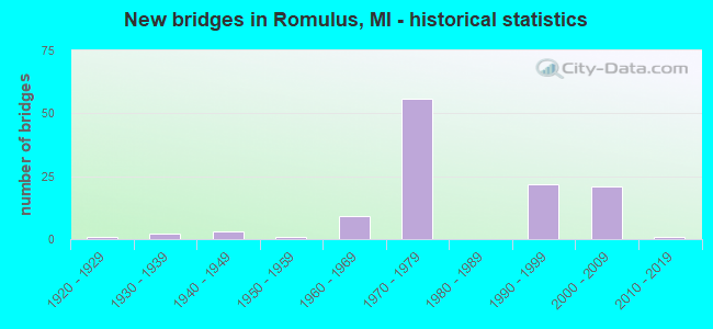
- New bridges - historical statistics
- 11920-1929
- 21930-1939
- 31940-1949
- 11950-1959
- 91960-1969
- 561970-1979
- 221990-1999
- 212000-2009
- 12010-2019

- Reconstructed bridges - Historical Statistics
- 11960-1969
- 21970-1979
- 01980-1989
- 41990-1999
- 72000-2009
- 42010-2019
- 12020-2022


- Bridge Condition - Deck
- 5.1%Excellent
- 11.9%Very good
- 47.5%Good
- 30.5%Satisfactory
- 5.1%Fair

- Bridge Condition - Superstructure
- 10.2%Very good
- 59.3%Good
- 20.3%Satisfactory
- 8.5%Fair
- 1.7%Serious

- Bridge Condition - Substructure
- 1.7%Excellent
- 16.9%Very good
- 54.2%Good
- 20.3%Satisfactory
- 6.8%Fair

- Bridge Condition - Channel
- 22.2%Very good
- 22.2%Good
- 27.8%Satisfactory
- 27.8%Fair

- Bridge Condition - Culverts
- 33.3%Good
- 66.7%Satisfactory
Find on map >> Show street view
Structure Number: 1214, Location: 2.6 MI S OF I-94 (Lat: 42.261942, Lng: -84.988442), Route carried "on" structure: Interstate 69, Year Built: 1968, Status: Open, Structure Length: 3.23m (10.60ft), Average Daily Traffic: 10,679 (year 2007), Truck Traffic: 34%, Average Future Daily Traffic: 25,600 (year 2027), Design Load: HS 20+Mod, Features Intersected: KALAMAZOO RIVER
Minimum Vertical Clearance: 30.48m (100.00ft), Kilometerpoint: 21.912, Lanes on structure: 2, Base Highway Network: Yes (Inventory Route: 129, Subroute: 1), Owner: State Highway Agency, Approaching Roadway Width: 11.9m (39.0ft), Material/Design: Prestressed concrete, Design/Construction: Stringer/Multi-beam, Number Of Spans In Main Unit: 2, Length of Maximum Span: 16.2m (53.1ft), Curb-To-Curb Width: 11.7m (38.4ft), Out-to-Out Width: 13.0m (42.7ft)
Condition: Deck: Satisfactory, Superstructure: Fair, Substructure: Satisfactory, Channel: Fair, Operating Rating: 75.5 metric tons, Method Used To Determine Operating Rating: Load Factor (LF) rating reported by rating factor (RF) method using MS18 loading, Inventory Rating: 45.0 metric tons, Method Used To Determine Inventory Rating: Load Factor (LF) rating reported by rating factor (RF) method using MS18 loading, Structural Evaluation: Somewhat better than minimum adequacy, Deck Geometry: Equal to present minimum criteria, Waterway Adequacy: Equal to present desirable criteria, Approach Roadway Alignment: Equal to present desirable criteria, Designated Inspection Frequency: Every 24 months, Inspection Date: July 2021, Deck Structure Type: Concrete Cast-file-Place, Wearing Surface/Protective System: Wearing Surface: Monolithic Concrete
Find on map >> Show street view
Structure Number: 111, Location: 5.3 MI E OF WASHTENAW COL (Lat: 42.220139, Lng: -83.439950), Route carried "on" structure: County highway 2057, Year Built: 1974, Status: Open, Structure Length: 8.04m (26.38ft), Average Daily Traffic: 15,500 (year 1995), Truck Traffic: 15%, Average Future Daily Traffic: 26,000 (year 2017), Design Load: HS 20, Features Intersected: I-94, Facility Carried by Structure: HAGGERTY RD
Minimum Vertical Clearance: 30.48m (100.00ft), Kilometerpoint: 1.167, Lanes on structure: 6, Lanes under structure: 8, Owner: State Highway Agency, Approaching Roadway Width: 26.8m (87.9ft), Material/Design: Steel, Design/Construction: Stringer/Multi-beam, Number Of Spans In Main Unit: 2, Length of Maximum Span: 40.8m (133.9ft), Curb or Sidewalk Widths: Left: 0.2m (0.7ft), Right: 0.2m (0.7ft), Curb-To-Curb Width: 26.8m (87.9ft), Out-to-Out Width: 27.5m (90.2ft)
Condition: Deck: Good, Superstructure: Satisfactory, Substructure: Good, Operating Rating: 81.2 metric tons, Method Used To Determine Operating Rating: Load Factor (LF), Inventory Rating: 48.6 metric tons, Method Used To Determine Inventory Rating: Load Factor (LF), Structural Evaluation: Equal to present minimum criteria, Deck Geometry: Better than present minimum criteria, Underclear: Equal to present minimum criteria, Approach Roadway Alignment: Equal to present desirable criteria, Length Of Structure Improvement: 8.05m (26.41ft), Designated Inspection Frequency: Every 24 months, Inspection Date: August 2020, Bridge Improvement Cost: $590,000, Roadway Improvement Cost: $37,000, Total Project Cost: $435,000, Deck Structure Type: Concrete Cast-file-Place, Wearing Surface/Protective System: Wearing Surface: Monolithic Concrete
Find on map >> Show street view
Structure Number: 11101, Location: 3 MI E OF BELLEVILLE (Lat: 42.220733, Lng: -83.424278), Route carried "on" structure: Interstate 94, Year Built: 1972, Status: Open, Structure Length: 3.11m (10.20ft), Average Daily Traffic: 57,166 (year 2007), Truck Traffic: 11%, Average Future Daily Traffic: 57,129 (year 2018), Design Load: HS 20, Features Intersected: HANNAN RD
Minimum Vertical Clearance: 30.48m (100.00ft), Kilometerpoint: 9.859, Lanes on structure: 3, Lanes under structure: 2, Base Highway Network: Yes (Inventory Route: 158, Subroute: 2), Owner: State Highway Agency, Approaching Roadway Width: 18.7m (61.4ft), Material/Design: Steel, Design/Construction: Stringer/Multi-beam, Number Of Spans In Main Unit: 1, Length of Maximum Span: 30.0m (98.4ft), Curb-To-Curb Width: 18.7m (61.4ft), Out-to-Out Width: 19.7m (64.6ft)
Condition: Deck: Good, Superstructure: Fair, Substructure: Good, Operating Rating: 93.6 metric tons, Method Used To Determine Operating Rating: Load Factor (LF) rating reported by rating factor (RF) method using MS18 loading, Inventory Rating: 56.1 metric tons, Method Used To Determine Inventory Rating: Load Factor (LF) rating reported by rating factor (RF) method using MS18 loading, Structural Evaluation: Somewhat better than minimum adequacy, Deck Geometry: Superior to present desirable criteria, Underclear: Meets minimum limits, Approach Roadway Alignment: Equal to present desirable criteria, Designated Inspection Frequency: Every 24 months, Inspection Date: August 2020, Deck Structure Type: Concrete Cast-file-Place, Wearing Surface/Protective System: Wearing Surface: Monolithic Concrete
Find on map >> Show street view
Structure Number: 11102, Location: 3 MI E OF BELLEVILLE (Lat: 42.220408, Lng: -83.424247), Route carried "on" structure: Interstate 94, Year Built: 1972, Status: Open, Structure Length: 3.23m (10.60ft), Average Daily Traffic: 57,166 (year 2007), Truck Traffic: 11%, Average Future Daily Traffic: 57,129 (year 2018), Design Load: HS 20, Features Intersected: HANNAN RD
Minimum Vertical Clearance: 30.48m (100.00ft), Kilometerpoint: 9.858, Lanes on structure: 3, Lanes under structure: 2, Base Highway Network: Yes (Inventory Route: 157, Subroute: 5), Owner: State Highway Agency, Approaching Roadway Width: 18.7m (61.4ft), Material/Design: Steel, Design/Construction: Stringer/Multi-beam, Number Of Spans In Main Unit: 1, Length of Maximum Span: 31.3m (102.7ft), Curb-To-Curb Width: 18.7m (61.4ft), Out-to-Out Width: 19.7m (64.6ft)
Condition: Deck: Good, Superstructure: Good, Substructure: Very good, Operating Rating: 72.6 metric tons, Method Used To Determine Operating Rating: Load Factor (LF) rating reported by rating factor (RF) method using MS18 loading, Inventory Rating: 43.4 metric tons, Method Used To Determine Inventory Rating: Load Factor (LF) rating reported by rating factor (RF) method using MS18 loading, Structural Evaluation: Better than present minimum criteria, Deck Geometry: Superior to present desirable criteria, Underclear: Equal to present minimum criteria, Approach Roadway Alignment: Equal to present desirable criteria, Designated Inspection Frequency: Every 24 months, Inspection Date: August 2020, Deck Structure Type: Concrete Cast-file-Place, Wearing Surface/Protective System: Wearing Surface: Monolithic Concrete, Deck Protection: Epoxy Coated Reinforcing
Find on map >> Show street view
Structure Number: 11107, Location: 4.0 MI W OF TAYLOR (Lat: 42.225533, Lng: -83.395414), Route carried "on" structure: Interstate 94, Year Built: 2003, Status: Open, Structure Length: 8.68m (28.48ft), Average Daily Traffic: 55,956 (year 2007), Truck Traffic: 15%, Average Future Daily Traffic: 57,789 (year 2018), Design Load: HS 25 or greater, Features Intersected: CSX RR & SHOOK RD
Minimum Vertical Clearance: 30.48m (100.00ft), Kilometerpoint: 12.326, Lanes on structure: 4, Lanes under structure: 2, Base Highway Network: Yes (Inventory Route: 157, Subroute: 5), Owner: State Highway Agency, Approaching Roadway Width: 16.4m (53.8ft), Skew: 1 degrees, Material/Design: Prestressed concrete, Design/Construction: Box Beam or Girders - Multiple, Number Of Spans In Main Unit: 4, Length of Maximum Span: 32.0m (105.0ft), Curb-To-Curb Width: 23.0m (75.5ft), Out-to-Out Width: 23.9m (78.4ft)
Condition: Deck: Satisfactory, Superstructure: Good, Substructure: Good, Operating Rating: 76.1 metric tons, Method Used To Determine Operating Rating: Load Factor (LF) rating reported by rating factor (RF) method using MS18 loading, Inventory Rating: 45.7 metric tons, Method Used To Determine Inventory Rating: Load Factor (LF) rating reported by rating factor (RF) method using MS18 loading, Structural Evaluation: Better than present minimum criteria, Deck Geometry: Superior to present desirable criteria, Underclear: Superior to present desirable criteria, Approach Roadway Alignment: Equal to present desirable criteria, Designated Inspection Frequency: Every 24 months, Inspection Date: August 2021, Deck Structure Type: Concrete Cast-file-Place, Wearing Surface/Protective System: Wearing Surface: Monolithic Concrete, Deck Protection: Epoxy Coated Reinforcing
Find on map >> Show street view
Structure Number: 11108, Location: 4.0 MI W OF TAYLOR (Lat: 42.226000, Lng: -83.395425), Route carried "on" structure: Interstate 94, Year Built: 2003, Status: Open, Structure Length: 8.68m (28.48ft), Average Daily Traffic: 55,956 (year 2007), Truck Traffic: 15%, Average Future Daily Traffic: 57,789 (year 2018), Design Load: HS 25 or greater, Features Intersected: CSX RR & SHOOK RD
Minimum Vertical Clearance: 30.48m (100.00ft), Kilometerpoint: 12.330, Lanes on structure: 4, Lanes under structure: 2, Base Highway Network: Yes (Inventory Route: 158, Subroute: 2), Owner: State Highway Agency, Approaching Roadway Width: 16.4m (53.8ft), Skew: 1 degrees, Material/Design: Prestressed concrete, Design/Construction: Box Beam or Girders - Multiple, Number Of Spans In Main Unit: 4, Length of Maximum Span: 32.0m (105.0ft), Curb-To-Curb Width: 23.0m (75.5ft), Out-to-Out Width: 23.9m (78.4ft)
Condition: Deck: Good, Superstructure: Good, Substructure: Good, Operating Rating: 82.0 metric tons, Method Used To Determine Operating Rating: Load Factor (LF) rating reported by rating factor (RF) method using MS18 loading, Inventory Rating: 49.2 metric tons, Method Used To Determine Inventory Rating: Load Factor (LF) rating reported by rating factor (RF) method using MS18 loading, Structural Evaluation: Better than present minimum criteria, Deck Geometry: Superior to present desirable criteria, Underclear: Superior to present desirable criteria, Approach Roadway Alignment: Equal to present desirable criteria, Designated Inspection Frequency: Every 24 months, Inspection Date: August 2021, Deck Structure Type: Concrete Cast-file-Place, Wearing Surface/Protective System: Wearing Surface: Monolithic Concrete, Deck Protection: Epoxy Coated Reinforcing
Find on map >> Show street view
Structure Number: 11111, Location: 4.3 MI W OF TAYLOR (Lat: 42.227967, Lng: -83.385572), Route carried "on" structure: Interstate 94, Year Built: 1962, Year Reconstructed: 1996, Status: Open, Structure Length: 4.28m (14.04ft), Average Daily Traffic: 74,175 (year 2019), Truck Traffic: 9%, Average Future Daily Traffic: 78,763 (year 2039), Design Load: HS 25 or greater, Features Intersected: WAYNE RD
Minimum Vertical Clearance: 30.48m (100.00ft), Kilometerpoint: 13.183, Lanes on structure: 4, Lanes under structure: 4, Base Highway Network: Yes (Inventory Route: 157, Subroute: 5), Owner: State Highway Agency, Approaching Roadway Width: 14.6m (47.9ft), Skew: 1 degrees, Material/Design: Steel, Design/Construction: Stringer/Multi-beam, Number Of Spans In Main Unit: 3, Length of Maximum Span: 17.3m (56.8ft), Curb-To-Curb Width: 17.3m (56.8ft), Out-to-Out Width: 18.3m (60.0ft)
Condition: Deck: Satisfactory, Superstructure: Good, Substructure: Very good, Operating Rating: 77.8 metric tons, Method Used To Determine Operating Rating: Load Factor (LF) rating reported by rating factor (RF) method using MS18 loading, Inventory Rating: 46.7 metric tons, Method Used To Determine Inventory Rating: Load Factor (LF) rating reported by rating factor (RF) method using MS18 loading, Structural Evaluation: Better than present minimum criteria, Deck Geometry: Meets minimum limits, Underclear: High priority of corrective action, Approach Roadway Alignment: Equal to present desirable criteria, Designated Inspection Frequency: Every 24 months, Inspection Date: August 2020, Deck Structure Type: Concrete Cast-file-Place, Wearing Surface/Protective System: Wearing Surface: Epoxy Overlay, Deck Protection: Epoxy Coated Reinforcing
Find on map >> Show street view
Structure Number: 11112, Location: 4.3 MI W OF TAYLOR (Lat: 42.228406, Lng: -83.385608), Route carried "on" structure: Interstate 94, Year Built: 1962, Year Reconstructed: 1996, Status: Open, Structure Length: 4.28m (14.04ft), Average Daily Traffic: 74,175 (year 2019), Truck Traffic: 9%, Average Future Daily Traffic: 78,763 (year 2039), Design Load: HS 25 or greater, Features Intersected: WAYNE RD
Minimum Vertical Clearance: 30.48m (100.00ft), Kilometerpoint: 13.183, Lanes on structure: 4, Lanes under structure: 4, Base Highway Network: Yes (Inventory Route: 158, Subroute: 2), Owner: State Highway Agency, Approaching Roadway Width: 14.6m (47.9ft), Skew: 1 degrees, Material/Design: Steel, Design/Construction: Stringer/Multi-beam, Number Of Spans In Main Unit: 3, Length of Maximum Span: 17.3m (56.8ft), Curb-To-Curb Width: 17.3m (56.8ft), Out-to-Out Width: 18.3m (60.0ft)
Condition: Deck: Satisfactory, Superstructure: Satisfactory, Substructure: Excellent, Operating Rating: 78.4 metric tons, Method Used To Determine Operating Rating: Load Factor (LF) rating reported by rating factor (RF) method using MS18 loading, Inventory Rating: 47.0 metric tons, Method Used To Determine Inventory Rating: Load Factor (LF) rating reported by rating factor (RF) method using MS18 loading, Structural Evaluation: Equal to present minimum criteria, Deck Geometry: Meets minimum limits, Underclear: High priority of corrective action, Approach Roadway Alignment: Equal to present desirable criteria, Designated Inspection Frequency: Every 24 months, Inspection Date: August 2020, Deck Structure Type: Concrete Cast-file-Place, Wearing Surface/Protective System: Wearing Surface: Epoxy Overlay, Deck Protection: Epoxy Coated Reinforcing
Find on map >> Show street view
Structure Number: 11113, Location: 1.9 MI W OF TAYLOR (Lat: 42.238703, Lng: -83.341475), Route carried "on" structure: Interstate 94, Year Built: 1993, Status: Open, Structure Length: 4.38m (14.37ft), Average Daily Traffic: 74,175 (year 2019), Truck Traffic: 9%, Average Future Daily Traffic: 78,763 (year 2039), Design Load: HS 25 or greater, Features Intersected: MERRIMAN RD
Minimum Vertical Clearance: 30.48m (100.00ft), Kilometerpoint: 17.011, Lanes on structure: 6, Lanes under structure: 6, Base Highway Network: Yes (Inventory Route: 157, Subroute: 5), Owner: State Highway Agency, Approaching Roadway Width: 20.4m (66.9ft), Skew: 10 degrees, Material/Design: Prestressed concrete, Design/Construction: Box Beam or Girders - Multiple, Number Of Spans In Main Unit: 2, Length of Maximum Span: 21.3m (69.9ft), Curb-To-Curb Width: 35.3m (115.8ft), Out-to-Out Width: 37.1m (121.7ft)
Condition: Deck: Very good, Superstructure: Fair, Substructure: Very good, Operating Rating: 82.0 metric tons, Method Used To Determine Operating Rating: Load Factor (LF) rating reported by rating factor (RF) method using MS18 loading, Inventory Rating: 46.0 metric tons, Method Used To Determine Inventory Rating: Load Factor (LF) rating reported by rating factor (RF) method using MS18 loading, Structural Evaluation: Somewhat better than minimum adequacy, Deck Geometry: Superior to present desirable criteria, Underclear: Meets minimum limits, Approach Roadway Alignment: Equal to present desirable criteria, Designated Inspection Frequency: Every 24 months, Inspection Date: August 2021, Deck Structure Type: Concrete Cast-file-Place, Wearing Surface/Protective System: Wearing Surface: Epoxy Overlay, Deck Protection: Epoxy Coated Reinforcing
Find on map >> Show street view
Structure Number: 11114, Location: 1.9 MI W OF TAYLOR (Lat: 42.239253, Lng: -83.341719), Route carried "on" structure: Interstate 94, Year Built: 1993, Status: Open, Structure Length: 4.38m (14.37ft), Average Daily Traffic: 74,175 (year 2019), Truck Traffic: 9%, Average Future Daily Traffic: 78,763 (year 2039), Design Load: HS 25 or greater, Features Intersected: MERRIMAN RD
Minimum Vertical Clearance: 30.48m (100.00ft), Kilometerpoint: 17.000, Lanes on structure: 5, Lanes under structure: 6, Base Highway Network: Yes (Inventory Route: 158, Subroute: 2), Owner: State Highway Agency, Approaching Roadway Width: 20.4m (66.9ft), Skew: 10 degrees, Material/Design: Prestressed concrete, Design/Construction: Box Beam or Girders - Multiple, Number Of Spans In Main Unit: 2, Length of Maximum Span: 21.3m (69.9ft), Curb-To-Curb Width: 31.6m (103.7ft), Out-to-Out Width: 33.5m (109.9ft)
Condition: Deck: Excellent, Superstructure: Satisfactory, Substructure: Very good, Operating Rating: 82.5 metric tons, Method Used To Determine Operating Rating: Load Factor (LF), Inventory Rating: 46.3 metric tons, Method Used To Determine Inventory Rating: Load Factor (LF), Structural Evaluation: Equal to present minimum criteria, Deck Geometry: Superior to present desirable criteria, Underclear: Meets minimum limits, Approach Roadway Alignment: Equal to present desirable criteria, Designated Inspection Frequency: Every 24 months, Inspection Date: August 2021, Deck Structure Type: Concrete Cast-file-Place, Wearing Surface/Protective System: Wearing Surface: Epoxy Overlay, Deck Protection: Epoxy Coated Reinforcing
Find on map >> Show street view
Structure Number: 11115, Location: 1.2 MI W OF TAYLOR (Lat: 42.242056, Lng: -83.327925), Route carried "on" structure: Interstate 94, Year Built: 1993, Status: Open, Structure Length: 4.43m (14.53ft), Average Daily Traffic: 74,175 (year 2019), Truck Traffic: 9%, Average Future Daily Traffic: 78,763 (year 2039), Design Load: HS 25 or greater, Features Intersected: MIDDLEBELT RD
Minimum Vertical Clearance: 30.48m (100.00ft), Kilometerpoint: 18.194, Lanes on structure: 5, Lanes under structure: 4, Base Highway Network: Yes (Inventory Route: 157, Subroute: 5), Owner: State Highway Agency, Approaching Roadway Width: 15.2m (49.9ft), Skew: 11 degrees, Material/Design: Prestressed concrete, Design/Construction: Box Beam or Girders - Multiple, Number Of Spans In Main Unit: 2, Length of Maximum Span: 21.9m (71.9ft), Curb-To-Curb Width: 31.6m (103.7ft), Out-to-Out Width: 33.5m (109.9ft)
Condition: Deck: Very good, Superstructure: Fair, Substructure: Good, Operating Rating: 79.7 metric tons, Method Used To Determine Operating Rating: Load Factor (LF) rating reported by rating factor (RF) method using MS18 loading, Inventory Rating: 41.5 metric tons, Method Used To Determine Inventory Rating: Load Factor (LF) rating reported by rating factor (RF) method using MS18 loading, Structural Evaluation: Somewhat better than minimum adequacy, Deck Geometry: Superior to present desirable criteria, Underclear: Meets minimum limits, Approach Roadway Alignment: Equal to present desirable criteria, Designated Inspection Frequency: Every 24 months, Inspection Date: August 2021, Deck Structure Type: Concrete Cast-file-Place, Wearing Surface/Protective System: Wearing Surface: Epoxy Overlay, Deck Protection: Epoxy Coated Reinforcing
Find on map >> Show street view
Structure Number: 11116, Location: 1.2 MI W OF TAYLOR (Lat: 42.242647, Lng: -83.327942), Route carried "on" structure: Interstate 94, Year Built: 1993, Status: Open, Structure Length: 4.43m (14.53ft), Average Daily Traffic: 74,175 (year 2019), Truck Traffic: 9%, Average Future Daily Traffic: 78,763 (year 2039), Design Load: HS 25 or greater, Features Intersected: MIDDLEBELT RD
Minimum Vertical Clearance: 30.48m (100.00ft), Kilometerpoint: 18.197, Lanes on structure: 6, Lanes under structure: 4, Base Highway Network: Yes (Inventory Route: 158, Subroute: 2), Owner: State Highway Agency, Approaching Roadway Width: 15.2m (49.9ft), Skew: 11 degrees, Material/Design: Prestressed concrete, Design/Construction: Box Beam or Girders - Multiple, Number Of Spans In Main Unit: 2, Length of Maximum Span: 21.9m (71.9ft), Curb-To-Curb Width: 35.3m (115.8ft), Out-to-Out Width: 37.1m (121.7ft)
Condition: Deck: Excellent, Superstructure: Satisfactory, Substructure: Good, Operating Rating: 70.0 metric tons, Method Used To Determine Operating Rating: Load Factor (LF) rating reported by rating factor (RF) method using MS18 loading, Inventory Rating: 27.9 metric tons, Method Used To Determine Inventory Rating: Load Factor (LF) rating reported by rating factor (RF) method using MS18 loading, Structural Evaluation: Equal to present minimum criteria, Deck Geometry: Superior to present desirable criteria, Underclear: High priority of corrective action, Approach Roadway Alignment: Equal to present desirable criteria, Designated Inspection Frequency: Every 24 months, Inspection Date: August 2021, Deck Structure Type: Concrete Cast-file-Place, Wearing Surface/Protective System: Wearing Surface: Epoxy Overlay, Deck Protection: Epoxy Coated Reinforcing
Find on map >> Show street view
Structure Number: 11143, Location: 4 MI E OF BELLEVILLE (Lat: 42.223019, Lng: -83.405214), Route carried "on" structure: City street 2057, Year Built: 1972, Status: Open, Structure Length: 13.11m (43.01ft), Average Daily Traffic: 4,623 (year 1997), Truck Traffic: 3%, Average Future Daily Traffic: 99,999 (year 2017), Design Load: HS 20, Features Intersected: I-94, Facility Carried by Structure: OZGA RD
Minimum Vertical Clearance: 30.48m (100.00ft), Kilometerpoint: 14.594, Lanes on structure: 2, Lanes under structure: 9, Owner: State Highway Agency, Approaching Roadway Width: 14.3m (46.9ft), Skew: 1 degrees, Material/Design: Steel continuous, Design/Construction: Stringer/Multi-beam, Number Of Spans In Main Unit: 4, Length of Maximum Span: 54.5m (178.8ft), Curb or Sidewalk Widths: Left: 0.2m (0.7ft), Right: 0.2m (0.7ft), Curb-To-Curb Width: 14.0m (45.9ft), Out-to-Out Width: 14.7m (48.2ft)
Condition: Deck: Satisfactory, Superstructure: Good, Substructure: Satisfactory, Operating Rating: 65.4 metric tons, Method Used To Determine Operating Rating: Load Factor (LF) rating reported by rating factor (RF) method using MS18 loading, Inventory Rating: 39.2 metric tons, Method Used To Determine Inventory Rating: Load Factor (LF) rating reported by rating factor (RF) method using MS18 loading, Structural Evaluation: Equal to present minimum criteria, Deck Geometry: Superior to present desirable criteria, Underclear: High priority of corrective action, Approach Roadway Alignment: Equal to present desirable criteria, Designated Inspection Frequency: Every 24 months, Inspection Date: September 2021, Deck Structure Type: Concrete Cast-file-Place, Wearing Surface/Protective System: Wearing Surface: Monolithic Concrete
Find on map >> Show street view
Structure Number: 11155, Location: I-94 AT MERRIMAN (Lat: 42.241831, Lng: -83.342297), Route carried "on" structure: Ramp Interstate 94, Year Built: 1993, Status: Open, Structure Length: 2.98m (9.78ft), Average Daily Traffic: 5,000 (year 1990), Truck Traffic: 3%, Average Future Daily Traffic: 14,000 (year 2010), Design Load: HS 25 or greater, Features Intersected: N BD MERRIMAN ROAD, Facility Carried by Structure: RAMP H TO SB MERRI
Minimum Vertical Clearance: 30.48m (100.00ft), Kilometerpoint: 0.161, Lanes on structure: 1, Lanes under structure: 2, Owner: State Highway Agency, Approaching Roadway Width: 8.5m (27.9ft), Skew: 2 degrees, Material/Design: Prestressed concrete, Design/Construction: Stringer/Multi-beam, Number Of Spans In Main Unit: 1, Length of Maximum Span: 29.8m (97.8ft), Curb-To-Curb Width: 9.1m (29.9ft), Out-to-Out Width: 10.1m (33.1ft)
Condition: Deck: Good, Superstructure: Satisfactory, Substructure: Satisfactory, Operating Rating: 77.8 metric tons, Method Used To Determine Operating Rating: Load Factor (LF) rating reported by rating factor (RF) method using MS18 loading, Inventory Rating: 24.9 metric tons, Method Used To Determine Inventory Rating: Load Factor (LF) rating reported by rating factor (RF) method using MS18 loading, Structural Evaluation: Equal to present minimum criteria, Deck Geometry: Superior to present desirable criteria, Underclear: High priority of corrective action, Approach Roadway Alignment: Equal to present desirable criteria, Designated Inspection Frequency: Every 24 months, Inspection Date: August 2021, Deck Structure Type: Concrete Cast-file-Place, Wearing Surface/Protective System: Wearing Surface: Monolithic Concrete, Deck Protection: Epoxy Coated Reinforcing
Find on map >> Show street view
Structure Number: 11884, Location: NEW BOSTON VILLAGE (Lat: 42.143047, Lng: -83.382303), Route carried "on" structure: Interstate 275, Year Built: 1974, Year Reconstructed: 1998, Status: Open, Structure Length: 9.01m (29.56ft), Average Daily Traffic: 23,572 (year 2007), Truck Traffic: 18%, Average Future Daily Traffic: 18,841 (year 2018), Design Load: HS 25 or greater, Features Intersected: HURON R & METROPARK PATH
Minimum Vertical Clearance: 30.48m (100.00ft), Kilometerpoint: 5.549, Lanes on structure: 4, Base Highway Network: Yes (Inventory Route: 160, Subroute: 10), Owner: State Highway Agency, Approaching Roadway Width: 19.5m (64.0ft), Skew: 1 degrees, Material/Design: Steel, Design/Construction: Stringer/Multi-beam, Number Of Spans In Main Unit: 4, Length of Maximum Span: 29.0m (95.1ft), Curb-To-Curb Width: 20.5m (67.3ft), Out-to-Out Width: 21.5m (70.5ft)
Condition: Deck: Satisfactory, Superstructure: Satisfactory, Substructure: Satisfactory, Channel: Satisfactory, Operating Rating: 62.2 metric tons, Method Used To Determine Operating Rating: Load Factor (LF) rating reported by rating factor (RF) method using MS18 loading, Inventory Rating: 37.3 metric tons, Method Used To Determine Inventory Rating: Load Factor (LF) rating reported by rating factor (RF) method using MS18 loading, Structural Evaluation: Equal to present minimum criteria, Deck Geometry: Equal to present minimum criteria, Waterway Adequacy: Better than present minimum criteria, Approach Roadway Alignment: Equal to present desirable criteria, Designated Inspection Frequency: Every 24 months, Underwater Inspection Frequency: Every 60 months, Inspection Date: May 2020, Underwater Inspection Date: April 2020, Deck Structure Type: Concrete Cast-file-Place, Wearing Surface/Protective System: Wearing Surface: Latex Concrete
Find on map >> Show street view
Structure Number: 11885, Location: NEW BOSTON VILLAGE (Lat: 42.143247, Lng: -83.381833), Route carried "on" structure: Interstate 275, Year Built: 1974, Status: Open, Structure Length: 8.69m (28.51ft), Average Daily Traffic: 23,572 (year 2007), Truck Traffic: 18%, Average Future Daily Traffic: 18,841 (year 2018), Design Load: HS 25 or greater, Features Intersected: HURON R & METROPARK PATH
Minimum Vertical Clearance: 30.48m (100.00ft), Kilometerpoint: 5.532, Lanes on structure: 3, Base Highway Network: Yes (Inventory Route: 160, Subroute: 8), Owner: State Highway Agency, Approaching Roadway Width: 15.8m (51.8ft), Skew: 2 degrees, Material/Design: Steel, Design/Construction: Stringer/Multi-beam, Number Of Spans In Main Unit: 4, Length of Maximum Span: 25.8m (84.6ft), Curb-To-Curb Width: 16.2m (53.1ft), Out-to-Out Width: 17.2m (56.4ft)
Condition: Deck: Satisfactory, Superstructure: Satisfactory, Substructure: Satisfactory, Channel: Fair, Operating Rating: 72.6 metric tons, Method Used To Determine Operating Rating: Load Factor (LF) rating reported by rating factor (RF) method using MS18 loading, Inventory Rating: 43.4 metric tons, Method Used To Determine Inventory Rating: Load Factor (LF) rating reported by rating factor (RF) method using MS18 loading, Structural Evaluation: Equal to present minimum criteria, Deck Geometry: Equal to present minimum criteria, Waterway Adequacy: Equal to present desirable criteria, Approach Roadway Alignment: Equal to present desirable criteria, Designated Inspection Frequency: Every 24 months, Underwater Inspection Frequency: Every 60 months, Inspection Date: May 2020, Underwater Inspection Date: April 2020, Deck Structure Type: Concrete Cast-file-Place, Wearing Surface/Protective System: Wearing Surface: Latex Concrete
Find on map >> Show street view
Structure Number: 11895, Location: IN ROMULUS (Lat: 42.209725, Lng: -83.394928), Route carried "on" structure: Interstate 275, Year Built: 1973, Status: Open, Structure Length: 5.47m (17.95ft), Average Daily Traffic: 35,403 (year 2007), Truck Traffic: 9%, Average Future Daily Traffic: 37,380 (year 2018), Design Load: HS 25 or greater, Features Intersected: CSX RR
Minimum Vertical Clearance: 30.48m (100.00ft), Kilometerpoint: 13.138, Lanes on structure: 3, Base Highway Network: Yes (Inventory Route: 160, Subroute: 10), Owner: State Highway Agency, Approaching Roadway Width: 17.3m (56.8ft), Skew: 3 degrees, Material/Design: Steel, Design/Construction: Stringer/Multi-beam, Number Of Spans In Main Unit: 3, Length of Maximum Span: 19.2m (63.0ft), Curb-To-Curb Width: 18.0m (59.1ft), Out-to-Out Width: 19.1m (62.7ft)
Condition: Deck: Good, Superstructure: Good, Substructure: Good, Operating Rating: 78.9 metric tons, Method Used To Determine Operating Rating: Load Factor (LF), Inventory Rating: 47.3 metric tons, Method Used To Determine Inventory Rating: Load Factor (LF), Structural Evaluation: Better than present minimum criteria, Deck Geometry: Better than present minimum criteria, Approach Roadway Alignment: Equal to present desirable criteria, Length Of Structure Improvement: 5.49m (18.01ft), Designated Inspection Frequency: Every 24 months, Inspection Date: September 2021, Bridge Improvement Cost: $212,000, Roadway Improvement Cost: $17,000, Total Project Cost: $197,000, Deck Structure Type: Concrete Cast-file-Place, Wearing Surface/Protective System: Wearing Surface: Latex Concrete, Membrane: Epoxy
Find on map >> Show street view
Structure Number: 11896, Location: IN ROMULUS (SW) (Lat: 42.210136, Lng: -83.394939), Route carried "on" structure: Interstate 275, Year Built: 1974, Status: Open, Structure Length: 5.80m (19.03ft), Average Daily Traffic: 35,403 (year 2007), Truck Traffic: 9%, Average Future Daily Traffic: 37,380 (year 2018), Design Load: HS 25 or greater, Features Intersected: CSX RR
Minimum Vertical Clearance: 30.48m (100.00ft), Kilometerpoint: 13.192, Lanes on structure: 3, Base Highway Network: Yes (Inventory Route: 160, Subroute: 8), Owner: State Highway Agency, Approaching Roadway Width: 17.3m (56.8ft), Skew: 3 degrees, Material/Design: Steel, Design/Construction: Stringer/Multi-beam, Number Of Spans In Main Unit: 3, Length of Maximum Span: 21.0m (68.9ft), Curb-To-Curb Width: 16.2m (53.1ft), Out-to-Out Width: 17.2m (56.4ft)
Condition: Deck: Satisfactory, Superstructure: Good, Substructure: Good, Operating Rating: 67.7 metric tons, Method Used To Determine Operating Rating: Load Factor (LF), Inventory Rating: 40.6 metric tons, Method Used To Determine Inventory Rating: Load Factor (LF), Structural Evaluation: Better than present minimum criteria, Deck Geometry: Equal to present minimum criteria, Approach Roadway Alignment: Equal to present desirable criteria, Designated Inspection Frequency: Every 24 months, Inspection Date: September 2021, Deck Structure Type: Concrete Cast-file-Place, Wearing Surface/Protective System: Wearing Surface: Latex Concrete, Membrane: Epoxy
Find on map >> Show street view
Structure Number: 11899, Location: 1.9 MI SE OF NEW BOSTON (Lat: 42.137239, Lng: -83.381686), Route carried "on" structure: County highway 8212, Year Built: 1974, Status: Open, Structure Length: 8.99m (29.49ft), Average Daily Traffic: 4,791 (year 1995), Truck Traffic: 8%, Average Future Daily Traffic: 7,400 (year 2017), Design Load: HS 20, Features Intersected: I-275, Facility Carried by Structure: SOUTH HURON
Minimum Vertical Clearance: 30.48m (100.00ft), Kilometerpoint: 3.315, Lanes on structure: 6, Lanes under structure: 7, Owner: State Highway Agency, Approaching Roadway Width: 24.7m (81.0ft), Material/Design: Steel, Design/Construction: Stringer/Multi-beam, Number Of Spans In Main Unit: 2, Length of Maximum Span: 46.0m (150.9ft), Curb or Sidewalk Widths: Left: 1.8m (5.9ft), Right: 0.0m, Curb-To-Curb Width: 24.8m (81.4ft), Out-to-Out Width: 27.5m (90.2ft)
Condition: Deck: Satisfactory, Superstructure: Good, Substructure: Satisfactory, Operating Rating: 75.5 metric tons, Method Used To Determine Operating Rating: Load Factor (LF) rating reported by rating factor (RF) method using MS18 loading, Inventory Rating: 45.0 metric tons, Method Used To Determine Inventory Rating: Load Factor (LF) rating reported by rating factor (RF) method using MS18 loading, Structural Evaluation: Equal to present minimum criteria, Deck Geometry: Somewhat better than minimum adequacy, Underclear: Somewhat better than minimum adequacy, Approach Roadway Alignment: Equal to present minimum criteria, Length Of Structure Improvement: 8.99m (29.49ft), Designated Inspection Frequency: Every 24 months, Inspection Date: May 2020, Bridge Improvement Cost: $872,000, Roadway Improvement Cost: $37,000, Total Project Cost: $440,000, Deck Structure Type: Concrete Cast-file-Place, Wearing Surface/Protective System: Wearing Surface: Monolithic Concrete
Find on map >> Show street view
Structure Number: 119, Location: 1.0 MI SE OF NEW BOSTON (Lat: 42.151897, Lng: -83.383486), Route carried "on" structure: County highway , Year Built: 1974, Year Reconstructed: 2010, Status: Open, Structure Length: 12.81m (42.03ft), Average Daily Traffic: 5,071 (year 1996), Truck Traffic: 8%, Average Future Daily Traffic: 7,700 (year 2017), Design Load: HS 20, Features Intersected: I-275, Facility Carried by Structure: HURON RIVER DRIVE
Minimum Vertical Clearance: 30.48m (100.00ft), Kilometerpoint: 2.142, Lanes on structure: 2, Lanes under structure: 6, Owner: State Highway Agency, Approaching Roadway Width: 14.6m (47.9ft), Skew: 4 degrees, Material/Design: Steel, Design/Construction: Stringer/Multi-beam, Number Of Spans In Main Unit: 4, Length of Maximum Span: 49.1m (161.1ft), Curb-To-Curb Width: 14.4m (47.2ft), Out-to-Out Width: 15.1m (49.5ft)
Condition: Deck: Good, Superstructure: Good, Substructure: Good, Operating Rating: 86.8 metric tons, Method Used To Determine Operating Rating: Load Factor (LF), Inventory Rating: 52.0 metric tons, Method Used To Determine Inventory Rating: Load Factor (LF), Structural Evaluation: Better than present minimum criteria, Deck Geometry: Superior to present desirable criteria, Underclear: Somewhat better than minimum adequacy, Approach Roadway Alignment: Better than present minimum criteria, Length Of Structure Improvement: 9.33m (30.61ft), Designated Inspection Frequency: Every 24 months, Inspection Date: May 2020, Bridge Improvement Cost: $519,000, Roadway Improvement Cost: $33,000, Total Project Cost: $385,000, Deck Structure Type: Concrete Cast-file-Place, Wearing Surface/Protective System: Wearing Surface: Monolithic Concrete
Find on map >> Show street view
Structure Number: 11901, Location: 0.7 MI E OF NEW BOSTON (Lat: 42.165539, Lng: -83.387517), Route carried "on" structure: County highway 8222, Year Built: 1974, Status: Open, Structure Length: 8.78m (28.81ft), Average Daily Traffic: 12,377 (year 1992), Truck Traffic: 15%, Average Future Daily Traffic: 20,300 (year 2017), Design Load: HS 20, Features Intersected: I-275, Facility Carried by Structure: SIBLEY RD
Minimum Vertical Clearance: 30.48m (100.00ft), Kilometerpoint: 1.273, Lanes on structure: 5, Lanes under structure: 6, Base Highway Network: Yes (Inventory Route: 160, Subroute: 8), Owner: State Highway Agency, Approaching Roadway Width: 26.8m (87.9ft), Material/Design: Steel, Design/Construction: Stringer/Multi-beam, Number Of Spans In Main Unit: 2, Length of Maximum Span: 43.9m (144.0ft), Curb or Sidewalk Widths: Left: 1.8m (5.9ft), Right: 1.8m (5.9ft), Curb-To-Curb Width: 19.5m (64.0ft), Out-to-Out Width: 23.9m (78.4ft)
Condition: Deck: Satisfactory, Superstructure: Good, Substructure: Good, Operating Rating: 82.6 metric tons, Method Used To Determine Operating Rating: Load Factor (LF) rating reported by rating factor (RF) method using MS18 loading, Inventory Rating: 49.6 metric tons, Method Used To Determine Inventory Rating: Load Factor (LF) rating reported by rating factor (RF) method using MS18 loading, Structural Evaluation: Better than present minimum criteria, Deck Geometry: Meets minimum limits, Underclear: Somewhat better than minimum adequacy, Approach Roadway Alignment: Equal to present desirable criteria, Designated Inspection Frequency: Every 24 months, Inspection Date: May 2020, Bridge Improvement Cost: $83,000, Deck Structure Type: Concrete Cast-file-Place, Wearing Surface/Protective System: Wearing Surface: Monolithic Concrete
Find on map >> Show street view
Structure Number: 11904, Location: IN ROMULUS (Lat: 42.208728, Lng: -83.393144), Route carried "on" structure: Interstate 275, Year Built: 1974, Status: Open, Structure Length: 6.40m (21.00ft), Average Daily Traffic: 35,403 (year 2007), Truck Traffic: 9%, Average Future Daily Traffic: 37,380 (year 2018), Design Load: HS 25 or greater, Features Intersected: NORTHLINE RD
Minimum Vertical Clearance: 30.48m (100.00ft), Kilometerpoint: 12.952, Lanes on structure: 3, Lanes under structure: 2, Base Highway Network: Yes (Inventory Route: 160, Subroute: 10), Owner: State Highway Agency, Approaching Roadway Width: 16.4m (53.8ft), Skew: 4 degrees, Material/Design: Steel, Design/Construction: Stringer/Multi-beam, Number Of Spans In Main Unit: 3, Length of Maximum Span: 32.2m (105.6ft), Curb-To-Curb Width: 18.0m (59.1ft), Out-to-Out Width: 19.1m (62.7ft)
Condition: Deck: Satisfactory, Superstructure: Good, Substructure: Good, Operating Rating: 81.3 metric tons, Method Used To Determine Operating Rating: Load Factor (LF) rating reported by rating factor (RF) method using MS18 loading, Inventory Rating: 48.6 metric tons, Method Used To Determine Inventory Rating: Load Factor (LF) rating reported by rating factor (RF) method using MS18 loading, Structural Evaluation: Better than present minimum criteria, Deck Geometry: Better than present minimum criteria, Underclear: Somewhat better than minimum adequacy, Approach Roadway Alignment: Equal to present desirable criteria, Designated Inspection Frequency: Every 24 months, Inspection Date: September 2021, Deck Structure Type: Concrete Cast-file-Place, Wearing Surface/Protective System: Wearing Surface: Monolithic Concrete
Find on map >> Show street view
Structure Number: 11905, Location: IN ROMULUS (Lat: 42.211986, Lng: -83.404756), Route carried "on" structure: Interstate 275, Year Built: 1974, Status: Open, Structure Length: 4.16m (13.65ft), Average Daily Traffic: 35,403 (year 2007), Truck Traffic: 9%, Average Future Daily Traffic: 37,380 (year 2018), Design Load: HS 25 or greater, Features Intersected: S HURON RIVER DRIVE
Minimum Vertical Clearance: 30.48m (100.00ft), Kilometerpoint: 13.989, Lanes on structure: 3, Lanes under structure: 2, Base Highway Network: Yes (Inventory Route: 160, Subroute: 10), Owner: State Highway Agency, Approaching Roadway Width: 16.2m (53.1ft), Skew: 2 degrees, Material/Design: Steel, Design/Construction: Stringer/Multi-beam, Number Of Spans In Main Unit: 1, Length of Maximum Span: 41.6m (136.5ft), Curb-To-Curb Width: 16.2m (53.1ft), Out-to-Out Width: 17.2m (56.4ft)
Condition: Deck: Good, Superstructure: Very good, Substructure: Good, Operating Rating: 97.2 metric tons, Method Used To Determine Operating Rating: Load Factor (LF) rating reported by rating factor (RF) method using MS18 loading, Inventory Rating: 59.3 metric tons, Method Used To Determine Inventory Rating: Load Factor (LF) rating reported by rating factor (RF) method using MS18 loading, Structural Evaluation: Better than present minimum criteria, Deck Geometry: Equal to present minimum criteria, Underclear: Equal to present minimum criteria, Approach Roadway Alignment: Equal to present desirable criteria, Length Of Structure Improvement: 4.18m (13.71ft), Designated Inspection Frequency: Every 24 months, Inspection Date: September 2021, Bridge Improvement Cost: $152,000, Roadway Improvement Cost: $9,000, Total Project Cost: $102,000, Deck Structure Type: Concrete Cast-file-Place, Wearing Surface/Protective System: Wearing Surface: Monolithic Concrete
Find on map >> Show street view
Structure Number: 11906, Location: IN ROMULUS (Lat: 42.215750, Lng: -83.409672), Route carried "on" structure: City street 2057, Year Built: 1974, Status: Open, Structure Length: 12.24m (40.16ft), Average Daily Traffic: 6,500 (year 1977), Truck Traffic: 3%, Average Future Daily Traffic: 6,500 (year 1977), Design Load: HS 20, Features Intersected: I-275, Facility Carried by Structure: W HURON RIVER DR
Minimum Vertical Clearance: 30.48m (100.00ft), Kilometerpoint: 6.776, Lanes on structure: 4, Lanes under structure: 7, Owner: State Highway Agency, Approaching Roadway Width: 15.8m (51.8ft), Skew: 32 degrees, Material/Design: Steel, Design/Construction: Stringer/Multi-beam, Number Of Spans In Main Unit: 4, Length of Maximum Span: 40.9m (134.2ft), Curb or Sidewalk Widths: Left: 1.8m (5.9ft), Right: 1.8m (5.9ft), Curb-To-Curb Width: 15.8m (51.8ft), Out-to-Out Width: 20.2m (66.3ft)
Condition: Deck: Satisfactory, Superstructure: Good, Substructure: Good, Operating Rating: 84.6 metric tons, Method Used To Determine Operating Rating: Load Factor (LF) rating reported by rating factor (RF) method using MS18 loading, Inventory Rating: 50.5 metric tons, Method Used To Determine Inventory Rating: Load Factor (LF) rating reported by rating factor (RF) method using MS18 loading, Structural Evaluation: Better than present minimum criteria, Deck Geometry: Meets minimum limits, Underclear: Somewhat better than minimum adequacy, Approach Roadway Alignment: Better than present minimum criteria, Designated Inspection Frequency: Every 24 months, Inspection Date: September 2021, Deck Structure Type: Concrete Cast-file-Place, Wearing Surface/Protective System: Wearing Surface: Monolithic Concrete
Find on map >> Show street view
Structure Number: 11907, Location: IN ROMULUS (Lat: 42.222039, Lng: -83.411958), Route carried "on" structure: Interstate 94, Year Built: 1972, Year Reconstructed: 2011, Status: Open, Structure Length: 10.97m (35.99ft), Average Daily Traffic: 57,166 (year 2007), Truck Traffic: 15%, Average Future Daily Traffic: 67,450 (year 2031), Design Load: HS 20+Mod, Features Intersected: I-275
Minimum Vertical Clearance: 30.48m (100.00ft), Kilometerpoint: 10.878, Lanes on structure: 4, Lanes under structure: 8, Base Highway Network: Yes (Inventory Route: 157, Subroute: 5), Owner: State Highway Agency, Approaching Roadway Width: 20.8m (68.2ft), Material/Design: Steel, Design/Construction: Stringer/Multi-beam, Number Of Spans In Main Unit: 4, Length of Maximum Span: 37.1m (121.7ft), Curb-To-Curb Width: 20.8m (68.2ft), Out-to-Out Width: 21.8m (71.5ft)
Condition: Deck: Good, Superstructure: Good, Substructure: Good, Operating Rating: 72.9 metric tons, Method Used To Determine Operating Rating: Load Factor (LF) rating reported by rating factor (RF) method using MS18 loading, Inventory Rating: 43.7 metric tons, Method Used To Determine Inventory Rating: Load Factor (LF) rating reported by rating factor (RF) method using MS18 loading, Structural Evaluation: Better than present minimum criteria, Deck Geometry: Equal to present minimum criteria, Underclear: Equal to present desirable criteria, Approach Roadway Alignment: Equal to present desirable criteria, Designated Inspection Frequency: Every 24 months, Inspection Date: August 2020, Bridge Improvement Cost: $1,308,000, Deck Structure Type: Concrete Cast-file-Place, Wearing Surface/Protective System: Wearing Surface: Latex Concrete, Deck Protection: Epoxy Coated Reinforcing
Find on map >> Show street view
Structure Number: 11908, Location: IN ROMULUS (Lat: 42.208731, Lng: -83.392414), Route carried "on" structure: Interstate 275, Year Built: 1974, Status: Open, Structure Length: 6.14m (20.14ft), Average Daily Traffic: 35,403 (year 2007), Truck Traffic: 9%, Average Future Daily Traffic: 37,380 (year 2018), Design Load: HS 25 or greater, Features Intersected: NORTHLINE RD
Minimum Vertical Clearance: 30.48m (100.00ft), Kilometerpoint: 12.932, Lanes on structure: 3, Lanes under structure: 2, Base Highway Network: Yes (Inventory Route: 160, Subroute: 8), Owner: State Highway Agency, Approaching Roadway Width: 16.4m (53.8ft), Skew: 4 degrees, Material/Design: Steel, Design/Construction: Stringer/Multi-beam, Number Of Spans In Main Unit: 3, Length of Maximum Span: 30.9m (101.4ft), Curb-To-Curb Width: 16.2m (53.1ft), Out-to-Out Width: 17.2m (56.4ft)
Condition: Deck: Satisfactory, Superstructure: Good, Substructure: Good, Operating Rating: 73.7 metric tons, Method Used To Determine Operating Rating: Load Factor (LF), Inventory Rating: 44.2 metric tons, Method Used To Determine Inventory Rating: Load Factor (LF), Structural Evaluation: Better than present minimum criteria, Deck Geometry: Equal to present minimum criteria, Underclear: Better than present minimum criteria, Approach Roadway Alignment: Equal to present desirable criteria, Designated Inspection Frequency: Every 24 months, Inspection Date: September 2021, Deck Structure Type: Concrete Cast-file-Place, Wearing Surface/Protective System: Wearing Surface: Monolithic Concrete
Find on map >> Show street view
Structure Number: 11909, Location: IN ROMULUS (Lat: 42.222444, Lng: -83.412069), Route carried "on" structure: Interstate 94, Year Built: 1972, Year Reconstructed: 2011, Status: Open, Structure Length: 10.97m (35.99ft), Average Daily Traffic: 57,166 (year 2007), Truck Traffic: 15%, Average Future Daily Traffic: 67,450 (year 2031), Design Load: HS 20+Mod, Features Intersected: I-275
Minimum Vertical Clearance: 30.48m (100.00ft), Kilometerpoint: 10.873, Lanes on structure: 3, Lanes under structure: 9, Base Highway Network: Yes (Inventory Route: 158, Subroute: 2), Owner: State Highway Agency, Approaching Roadway Width: 18.3m (60.0ft), Material/Design: Steel, Design/Construction: Stringer/Multi-beam, Number Of Spans In Main Unit: 4, Length of Maximum Span: 37.3m (122.4ft), Curb-To-Curb Width: 18.3m (60.0ft), Out-to-Out Width: 19.3m (63.3ft)
Condition: Deck: Good, Superstructure: Good, Substructure: Good, Operating Rating: 73.4 metric tons, Method Used To Determine Operating Rating: Load Factor (LF), Inventory Rating: 44.0 metric tons, Method Used To Determine Inventory Rating: Load Factor (LF), Structural Evaluation: Better than present minimum criteria, Deck Geometry: Better than present minimum criteria, Underclear: Equal to present desirable criteria, Approach Roadway Alignment: Equal to present desirable criteria, Designated Inspection Frequency: Every 24 months, Inspection Date: August 2020, Deck Structure Type: Concrete Cast-file-Place, Wearing Surface/Protective System: Wearing Surface: Monolithic Concrete, Deck Protection: Epoxy Coated Reinforcing
Find on map >> Show street view
Structure Number: 1191, Location: IN ROMULUS (Lat: 42.222636, Lng: -83.412119), Route carried "on" structure: Ramp Interstate 94, Year Built: 1972, Year Reconstructed: 2010, Status: Open, Structure Length: 10.97m (35.99ft), Average Daily Traffic: 10,200 (year 1982), Truck Traffic: 3%, Average Future Daily Traffic: 10,200 (year 1977), Design Load: HS 20+Mod, Features Intersected: I-275
Minimum Vertical Clearance: 30.48m (100.00ft), Kilometerpoint: 0.634, Lanes on structure: 2, Lanes under structure: 9, Owner: State Highway Agency, Approaching Roadway Width: 11.5m (37.7ft), Material/Design: Steel, Design/Construction: Stringer/Multi-beam, Number Of Spans In Main Unit: 4, Length of Maximum Span: 37.3m (122.4ft), Curb-To-Curb Width: 11.6m (38.1ft), Out-to-Out Width: 12.6m (41.3ft)
Condition: Deck: Very good, Superstructure: Satisfactory, Substructure: Good, Operating Rating: 72.3 metric tons, Method Used To Determine Operating Rating: Load Factor (LF) rating reported by rating factor (RF) method using MS18 loading, Inventory Rating: 43.4 metric tons, Method Used To Determine Inventory Rating: Load Factor (LF) rating reported by rating factor (RF) method using MS18 loading, Structural Evaluation: Equal to present minimum criteria, Deck Geometry: Superior to present desirable criteria, Underclear: Equal to present minimum criteria, Approach Roadway Alignment: Equal to present desirable criteria, Designated Inspection Frequency: Every 24 months, Other Special Inspection Frequency: Every 24 months, Inspection Date: August 2020, Other Special Inspection Date: August 2021, Deck Structure Type: Concrete Cast-file-Place, Wearing Surface/Protective System: Wearing Surface: Monolithic Concrete, Deck Protection: Epoxy Coated Reinforcing
Find on map >> Show street view
Structure Number: 11911, Location: IN ROMULUS (Lat: 42.212392, Lng: -83.404772), Route carried "on" structure: Interstate 275, Year Built: 1974, Status: Open, Structure Length: 4.19m (13.75ft), Average Daily Traffic: 35,403 (year 2007), Truck Traffic: 9%, Average Future Daily Traffic: 37,380 (year 2018), Design Load: HS 25 or greater, Features Intersected: S HURON RIVER DRIVE
Minimum Vertical Clearance: 30.48m (100.00ft), Kilometerpoint: 14.045, Lanes on structure: 3, Lanes under structure: 2, Base Highway Network: Yes (Inventory Route: 160, Subroute: 8), Owner: State Highway Agency, Approaching Roadway Width: 16.2m (53.1ft), Skew: 2 degrees, Material/Design: Steel, Design/Construction: Stringer/Multi-beam, Number Of Spans In Main Unit: 1, Length of Maximum Span: 41.9m (137.5ft), Curb-To-Curb Width: 16.2m (53.1ft), Out-to-Out Width: 17.2m (56.4ft)
Condition: Deck: Good, Superstructure: Good, Substructure: Satisfactory, Operating Rating: 97.2 metric tons, Method Used To Determine Operating Rating: Load Factor (LF) rating reported by rating factor (RF) method using MS18 loading, Inventory Rating: 59.3 metric tons, Method Used To Determine Inventory Rating: Load Factor (LF) rating reported by rating factor (RF) method using MS18 loading, Structural Evaluation: Equal to present minimum criteria, Deck Geometry: Equal to present minimum criteria, Underclear: Somewhat better than minimum adequacy, Approach Roadway Alignment: Equal to present desirable criteria, Length Of Structure Improvement: 4.21m (13.81ft), Designated Inspection Frequency: Every 24 months, Inspection Date: September 2021, Bridge Improvement Cost: $159,000, Roadway Improvement Cost: $9,000, Total Project Cost: $106,000, Deck Structure Type: Concrete Cast-file-Place, Wearing Surface/Protective System: Wearing Surface: Monolithic Concrete
Find on map >> Show street view
Structure Number: 11912, Location: IN ROMULUS (Lat: 42.221983, Lng: -83.415217), Route carried "on" structure: Interstate 94, Year Built: 1972, Year Reconstructed: 2011, Status: Open, Structure Length: 3.75m (12.30ft), Average Daily Traffic: 57,166 (year 2007), Truck Traffic: 11%, Average Future Daily Traffic: 67,450 (year 2031), Design Load: HS 20+Mod, Features Intersected: I-275 SB TO I-94 EB RAMP
Minimum Vertical Clearance: 30.48m (100.00ft), Kilometerpoint: 10.633, Lanes on structure: 3, Lanes under structure: 1, Base Highway Network: Yes (Inventory Route: 158, Subroute: 2), Owner: State Highway Agency, Approaching Roadway Width: 18.3m (60.0ft), Skew: 11 degrees, Material/Design: Steel, Design/Construction: Stringer/Multi-beam, Number Of Spans In Main Unit: 1, Length of Maximum Span: 36.3m (119.1ft), Curb-To-Curb Width: 18.3m (60.0ft), Out-to-Out Width: 19.3m (63.3ft)
Condition: Deck: Very good, Superstructure: Good, Substructure: Good, Inventory Rating: 66.1 metric tons, Method Used To Determine Inventory Rating: Load Factor (LF), Structural Evaluation: Better than present minimum criteria, Deck Geometry: Better than present minimum criteria, Underclear: Better than present minimum criteria, Approach Roadway Alignment: Equal to present desirable criteria, Designated Inspection Frequency: Every 24 months, Inspection Date: August 2020, Deck Structure Type: Concrete Cast-file-Place, Wearing Surface/Protective System: Wearing Surface: Monolithic Concrete, Deck Protection: Epoxy Coated Reinforcing
Find on map >> Show street view
Structure Number: 11913, Location: IN ROMULUS (Lat: 42.222153, Lng: -83.415308), Route carried "on" structure: Ramp Interstate 94, Year Built: 1972, Year Reconstructed: 2010, Status: Open, Structure Length: 3.73m (12.24ft), Average Daily Traffic: 4,400 (year 1982), Truck Traffic: 3%, Average Future Daily Traffic: 5,060 (year 2002), Design Load: HS 20+Mod, Features Intersected: I-275 SB TO I-94 EB RAMP
Minimum Vertical Clearance: 30.48m (100.00ft), Kilometerpoint: 0.389, Lanes on structure: 1, Lanes under structure: 2, Owner: State Highway Agency, Approaching Roadway Width: 10.9m (35.8ft), Skew: 11 degrees, Material/Design: Steel, Design/Construction: Stringer/Multi-beam, Number Of Spans In Main Unit: 1, Length of Maximum Span: 36.1m (118.4ft), Curb-To-Curb Width: 8.5m (27.9ft), Out-to-Out Width: 9.5m (31.2ft)
Condition: Deck: Good, Superstructure: Satisfactory, Substructure: Fair, Inventory Rating: 60.3 metric tons, Method Used To Determine Inventory Rating: Load Factor (LF), Structural Evaluation: Somewhat better than minimum adequacy, Deck Geometry: Superior to present desirable criteria, Underclear: Equal to present minimum criteria, Approach Roadway Alignment: Equal to present desirable criteria, Designated Inspection Frequency: Every 24 months, Inspection Date: August 2020, Deck Structure Type: Concrete Cast-file-Place, Wearing Surface/Protective System: Wearing Surface: Monolithic Concrete, Deck Protection: Epoxy Coated Reinforcing
Find on map >> Show street view
Structure Number: 11915, Location: IN ROMULUS (WEST) (Lat: 42.220233, Lng: -83.411514), Route carried "on" structure: Ramp Interstate 94, Year Built: 1974, Status: Open, Structure Length: 11.09m (36.38ft), Average Daily Traffic: 7,700 (year 1982), Truck Traffic: 3%, Average Future Daily Traffic: 7,700 (year 1977), Design Load: HS 25 or greater, Features Intersected: I-275
Minimum Vertical Clearance: 30.48m (100.00ft), Kilometerpoint: 0.552, Lanes on structure: 1, Lanes under structure: 7, Owner: State Highway Agency, Approaching Roadway Width: 13.1m (43.0ft), Skew: 2 degrees, Material/Design: Steel, Design/Construction: Stringer/Multi-beam, Number Of Spans In Main Unit: 4, Length of Maximum Span: 37.7m (123.7ft), Curb-To-Curb Width: 11.1m (36.4ft), Out-to-Out Width: 12.1m (39.7ft)
Condition: Deck: Fair, Superstructure: Good, Substructure: Good, Operating Rating: 71.9 metric tons, Method Used To Determine Operating Rating: Load Factor (LF) rating reported by rating factor (RF) method using MS18 loading, Inventory Rating: 43.1 metric tons, Method Used To Determine Inventory Rating: Load Factor (LF) rating reported by rating factor (RF) method using MS18 loading, Structural Evaluation: Better than present minimum criteria, Deck Geometry: Superior to present desirable criteria, Underclear: Somewhat better than minimum adequacy, Approach Roadway Alignment: Equal to present desirable criteria, Designated Inspection Frequency: Every 24 months, Inspection Date: August 2020, Deck Structure Type: Concrete Cast-file-Place, Wearing Surface/Protective System: Wearing Surface: Monolithic Concrete
Find on map >> Show street view
Structure Number: 11924, Location: 1 MI SW OF WAYNE (Lat: 42.248667, Lng: -83.443175), Route carried "on" structure: Ramp Interstate 275, Year Built: 1974, Year Reconstructed: 2012, Status: Open, Structure Length: 1.65m (5.41ft), Average Daily Traffic: 4,460 (year 2012), Truck Traffic: 9%, Average Future Daily Traffic: 5,530 (year 2032), Design Load: HS 25 or greater, Features Intersected: MCCLAUGHREY DRAIN
Minimum Vertical Clearance: 30.48m (100.00ft), Kilometerpoint: 0.063, Lanes on structure: 1, Owner: State Highway Agency, Approaching Roadway Width: 6.6m (21.7ft), Material/Design: Steel, Design/Construction: Stringer/Multi-beam, Number Of Spans In Main Unit: 1, Length of Maximum Span: 15.7m (51.5ft), Curb-To-Curb Width: 7.9m (25.9ft), Out-to-Out Width: 8.9m (29.2ft)
Condition: Deck: Good, Superstructure: Good, Substructure: Good, Channel: Satisfactory, Operating Rating: 78.7 metric tons, Method Used To Determine Operating Rating: Load Factor (LF) rating reported by rating factor (RF) method using MS18 loading, Inventory Rating: 47.3 metric tons, Method Used To Determine Inventory Rating: Load Factor (LF) rating reported by rating factor (RF) method using MS18 loading, Structural Evaluation: Better than present minimum criteria, Deck Geometry: Equal to present desirable criteria, Waterway Adequacy: Equal to present desirable criteria, Approach Roadway Alignment: Equal to present desirable criteria, Designated Inspection Frequency: Every 24 months, Inspection Date: October 2020, Deck Structure Type: Concrete Cast-file-Place, Wearing Surface/Protective System: Wearing Surface: Latex Concrete
Find on map >> Show street view
Structure Number: 11925, Location: 1 MI SW OF WAYNE (Lat: 42.248667, Lng: -83.440239), Route carried "on" structure: Interstate 275, Year Built: 1974, Status: Open, Structure Length: 1.65m (5.41ft), Average Daily Traffic: 44,965 (year 2007), Truck Traffic: 9%, Average Future Daily Traffic: 57,850 (year 2042), Design Load: HS 25 or greater, Features Intersected: MCCLAUGHREY DRAIN
Minimum Vertical Clearance: 30.48m (100.00ft), Kilometerpoint: 19.615, Lanes on structure: 3, Base Highway Network: Yes (Inventory Route: 160, Subroute: 10), Owner: State Highway Agency, Approaching Roadway Width: 16.8m (55.1ft), Skew: 1 degrees, Material/Design: Steel, Design/Construction: Stringer/Multi-beam, Number Of Spans In Main Unit: 1, Length of Maximum Span: 15.5m (50.9ft), Curb-To-Curb Width: 16.2m (53.1ft), Out-to-Out Width: 17.2m (56.4ft)
Condition: Deck: Good, Superstructure: Satisfactory, Substructure: Good, Channel: Satisfactory, Operating Rating: 97.2 metric tons, Method Used To Determine Operating Rating: Load Factor (LF) rating reported by rating factor (RF) method using MS18 loading, Inventory Rating: 62.5 metric tons, Method Used To Determine Inventory Rating: Load Factor (LF) rating reported by rating factor (RF) method using MS18 loading, Structural Evaluation: Equal to present minimum criteria, Deck Geometry: Equal to present minimum criteria, Waterway Adequacy: Equal to present desirable criteria, Approach Roadway Alignment: Equal to present desirable criteria, Designated Inspection Frequency: Every 24 months, Inspection Date: October 2020, Deck Structure Type: Concrete Cast-file-Place, Wearing Surface/Protective System: Wearing Surface: Latex Concrete
Find on map >> Show street view
Structure Number: 11926, Location: 1 MI SW OF WAYNE (Lat: 42.248669, Lng: -83.439753), Route carried "on" structure: Interstate 275, Year Built: 1974, Status: Open, Structure Length: 1.65m (5.41ft), Average Daily Traffic: 44,965 (year 2007), Truck Traffic: 9%, Average Future Daily Traffic: 51,850 (year 2042), Design Load: HS 25 or greater, Features Intersected: MCCLAUGHREY DRAIN
Minimum Vertical Clearance: 30.48m (100.00ft), Kilometerpoint: 19.604, Lanes on structure: 3, Base Highway Network: Yes (Inventory Route: 160, Subroute: 8), Owner: State Highway Agency, Approaching Roadway Width: 16.5m (54.1ft), Skew: 1 degrees, Material/Design: Steel, Design/Construction: Stringer/Multi-beam, Number Of Spans In Main Unit: 1, Length of Maximum Span: 15.5m (50.9ft), Curb-To-Curb Width: 16.2m (53.1ft), Out-to-Out Width: 17.2m (56.4ft)
Condition: Deck: Good, Superstructure: Satisfactory, Substructure: Good, Channel: Satisfactory, Operating Rating: 97.2 metric tons, Method Used To Determine Operating Rating: Load Factor (LF) rating reported by rating factor (RF) method using MS18 loading, Inventory Rating: 62.5 metric tons, Method Used To Determine Inventory Rating: Load Factor (LF) rating reported by rating factor (RF) method using MS18 loading, Structural Evaluation: Equal to present minimum criteria, Deck Geometry: Equal to present minimum criteria, Waterway Adequacy: Equal to present desirable criteria, Approach Roadway Alignment: Equal to present desirable criteria, Designated Inspection Frequency: Every 24 months, Inspection Date: October 2020, Deck Structure Type: Concrete Cast-file-Place, Wearing Surface/Protective System: Wearing Surface: Latex Concrete
Find on map >> Show street view
Structure Number: 11927, Location: 1 MI SW OF WAYNE (Lat: 42.248642, Lng: -83.436919), Route carried "on" structure: Ramp Interstate 275, Year Built: 1974, Year Reconstructed: 2012, Status: Open, Structure Length: 1.65m (5.41ft), Average Daily Traffic: 4,160 (year 2012), Truck Traffic: 9%, Average Future Daily Traffic: 5,200 (year 2032), Design Load: HS 25 or greater, Features Intersected: MCCLAUGHERY DRAIN
Minimum Vertical Clearance: 30.48m (100.00ft), Kilometerpoint: 0.641, Lanes on structure: 2, Owner: State Highway Agency, Approaching Roadway Width: 9.1m (29.9ft), Material/Design: Steel, Design/Construction: Stringer/Multi-beam, Number Of Spans In Main Unit: 1, Length of Maximum Span: 15.7m (51.5ft), Curb-To-Curb Width: 10.5m (34.4ft), Out-to-Out Width: 11.5m (37.7ft)
Condition: Deck: Good, Superstructure: Good, Substructure: Good, Channel: Very good, Operating Rating: 91.4 metric tons, Method Used To Determine Operating Rating: Load Factor (LF) rating reported by rating factor (RF) method using MS18 loading, Inventory Rating: 54.8 metric tons, Method Used To Determine Inventory Rating: Load Factor (LF) rating reported by rating factor (RF) method using MS18 loading, Structural Evaluation: Better than present minimum criteria, Deck Geometry: Better than present minimum criteria, Waterway Adequacy: Equal to present desirable criteria, Approach Roadway Alignment: Equal to present desirable criteria, Designated Inspection Frequency: Every 24 months, Inspection Date: October 2020, Deck Structure Type: Concrete Cast-file-Place, Wearing Surface/Protective System: Wearing Surface: Latex Concrete
Find on map >> Show street view
Structure Number: 11943, Location: IN ROMULUS (Lat: 42.229314, Lng: -83.424736), Route carried "on" structure: County highway 2057, Year Built: 1974, Year Reconstructed: 2012, Status: Open, Structure Length: 9.08m (29.79ft), Average Daily Traffic: 3,000 (year 1974), Truck Traffic: 3%, Average Future Daily Traffic: 3,000 (year 1977), Design Load: HS 20, Features Intersected: I-275, Facility Carried by Structure: HANNAN RD
Minimum Vertical Clearance: 30.48m (100.00ft), Kilometerpoint: 8.034, Lanes on structure: 2, Lanes under structure: 6, Owner: State Highway Agency, Approaching Roadway Width: 14.7m (48.2ft), Skew: 1 degrees, Material/Design: Steel, Design/Construction: Stringer/Multi-beam, Number Of Spans In Main Unit: 2, Length of Maximum Span: 45.0m (147.6ft), Curb-To-Curb Width: 13.6m (44.6ft), Out-to-Out Width: 14.8m (48.6ft)
Condition: Deck: Good, Superstructure: Very good, Substructure: Very good, Operating Rating: 91.0 metric tons, Method Used To Determine Operating Rating: Load Factor (LF), Inventory Rating: 54.5 metric tons, Method Used To Determine Inventory Rating: Load Factor (LF), Structural Evaluation: Equal to present desirable criteria, Deck Geometry: Superior to present desirable criteria, Underclear: Somewhat better than minimum adequacy, Approach Roadway Alignment: Equal to present desirable criteria, Designated Inspection Frequency: Every 24 months, Inspection Date: August 2020, Deck Structure Type: Concrete Cast-file-Place, Wearing Surface/Protective System: Wearing Surface: Latex Concrete
Find on map >> Show street view
Structure Number: 11944, Location: 3.0 MI NE OF BELLEVILLE (Lat: 42.235761, Lng: -83.437836), Route carried "on" structure: County highway 2000, Year Built: 1974, Year Reconstructed: 2012, Status: Open, Structure Length: 8.90m (29.20ft), Average Daily Traffic: 780 (year 1996), Truck Traffic: 4%, Average Future Daily Traffic: 1,300 (year 2017), Design Load: HS 20, Features Intersected: I-275, Facility Carried by Structure: TYLER RD.
Minimum Vertical Clearance: 30.48m (100.00ft), Kilometerpoint: 5.488, Lanes on structure: 2, Lanes under structure: 6, Owner: State Highway Agency, Approaching Roadway Width: 12.3m (40.4ft), Material/Design: Steel, Design/Construction: Stringer/Multi-beam, Number Of Spans In Main Unit: 2, Length of Maximum Span: 44.2m (145.0ft), Curb-To-Curb Width: 12.3m (40.4ft), Out-to-Out Width: 13.4m (44.0ft)
Condition: Deck: Good, Superstructure: Very good, Substructure: Good, Inventory Rating: 61.6 metric tons, Method Used To Determine Inventory Rating: Load Factor (LF), Structural Evaluation: Better than present minimum criteria, Deck Geometry: Superior to present desirable criteria, Underclear: Equal to present minimum criteria, Approach Roadway Alignment: Equal to present minimum criteria, Designated Inspection Frequency: Every 24 months, Inspection Date: August 2020, Deck Structure Type: Concrete Cast-file-Place, Wearing Surface/Protective System: Wearing Surface: Latex Concrete