Bridge Statistics for Richland, Washington (WA)
Condition, Traffic, Stress, Structural Evaluation, Project Costs
- National Bridge Inventory (NBI) Statistics
- 67Number of bridges
- 1,499ft / 457mTotal length
- $299,466,000Total costs
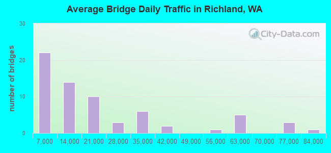
- 1,325,085Total average daily traffic
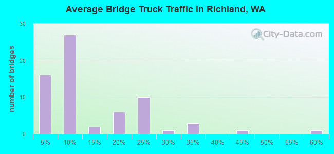
- 101,490Total average daily truck traffic
- National Bridge Inventory (NBI) Registered Bridges for Richland
- No street view available for this location
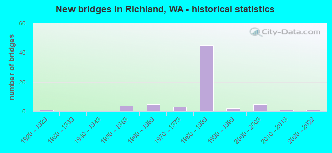
- New bridges - historical statistics
- 11920-1929
- 41950-1959
- 51960-1969
- 31970-1979
- 451980-1989
- 21990-1999
- 52000-2009
- 12010-2019
- 12020-2022
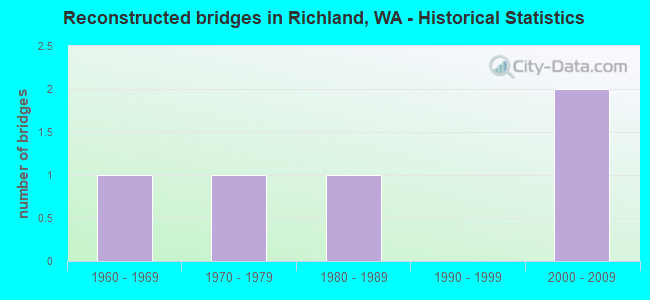
- Reconstructed bridges - Historical Statistics
- 11960-1969
- 11970-1979
- 11980-1989
- 01990-1999
- 22000-2009
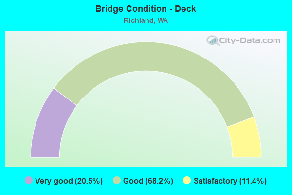
- Bridge Condition - Deck
- 20.5%Very good
- 68.2%Good
- 11.4%Satisfactory
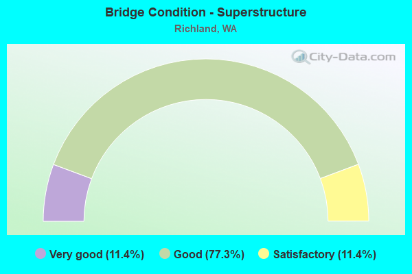
- Bridge Condition - Superstructure
- 11.4%Very good
- 77.3%Good
- 11.4%Satisfactory
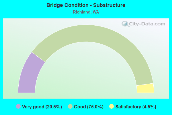
- Bridge Condition - Substructure
- 20.5%Very good
- 75.0%Good
- 4.5%Satisfactory
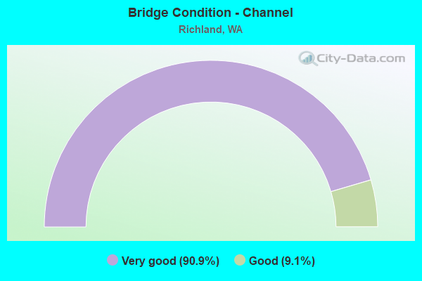
- Bridge Condition - Channel
- 90.9%Very good
- 9.1%Good
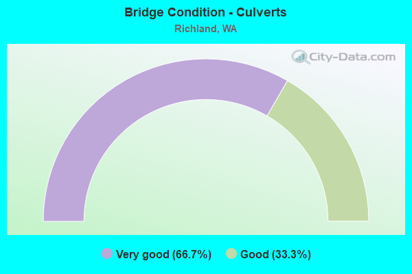
- Bridge Condition - Culverts
- 66.7%Very good
- 33.3%Good
Find on map >> Show street view
Structure Number: 11PECL056, Location: NR PASCO WA (Lat: 46.358378, Lng: -119.251164), Route carried "on" structure: ServiceOther road , Year Built: 1958, Status: Open, Structure Length: 0.67m (2.20ft), Average Daily Traffic: 5 (year 2021), Truck Traffic: 30%, Average Future Daily Traffic: 5 (year 2041), Features Intersected: ESQUATZEL DIVERS CHANNEL, Facility Carried by Structure: CHUTE ACCESS
Minimum Vertical Clearance: 30+ m (98+ ft), Kilometerpoint: 0.000, Lanes on structure: 1, Owner: Bureau of Reclamation, Maintenance Responsibility: Local Agency, Approaching Roadway Width: 4.3m (14.1ft), Material/Design: Concrete, Design/Construction: Slab, Number Of Spans In Main Unit: 1, Length of Maximum Span: 6.4m (21.0ft), Curb or Sidewalk Widths: Left: 0.3m (1.0ft), Right: 0.3m (1.0ft), Curb-To-Curb Width: 3.7m (12.1ft), Out-to-Out Width: 4.3m (14.1ft)
Condition: Deck: Very good, Superstructure: Good, Substructure: Very good, Channel: Very good, Operating Rating: 49.2 metric tons, Method Used To Determine Operating Rating: Load Factor (LF), Inventory Rating: 29.4 metric tons, Method Used To Determine Inventory Rating: Load Factor (LF), Structural Evaluation: Better than present minimum criteria, Deck Geometry: Meets minimum limits, Waterway Adequacy: Superior to present desirable criteria, Approach Roadway Alignment: Somewhat better than minimum adequacy, Designated Inspection Frequency: Every 24 months, Inspection Date: March 2021, Deck Structure Type: Concrete Cast-file-Place
Find on map >> Show street view
Structure Number: 1281A, Location: 1.2 NW JCT N STEPTOE ST (Lat: 46.244475, Lng: -119.270056), Route carried "on" structure: City street 1080, Year Built: 1929, Status: Open, Structure Length: 1.28m (4.20ft), Average Daily Traffic: 2,000 (year 2020), Truck Traffic: 5%, Average Future Daily Traffic: 4,000 (year 2040), Design Load: H 15, Features Intersected: COLUMBIA IRR DIST CANAL, Facility Carried by Structure: COLUMBIA PRK TRAIL
Minimum Vertical Clearance: 30+ m (98+ ft), Kilometerpoint: 0.001, Lanes on structure: 2, Owner: City or Municipal Highway Agency, Approaching Roadway Width: 9.4m (30.8ft), Skew: 3 degrees, Material/Design: Concrete, Design/Construction: Tee Beam, Number Of Spans In Main Unit: 1, Length of Maximum Span: 12.5m (41.0ft), Curb-To-Curb Width: 7.3m (24.0ft), Out-to-Out Width: 9.0m (29.5ft)
Condition: Deck: Good, Superstructure: Satisfactory, Substructure: Good, Channel: Very good, Operating Rating: 41.1 metric tons, Method Used To Determine Operating Rating: Load Factor (LF) rating reported by rating factor (RF) method using MS18 loading, Inventory Rating: 24.6 metric tons, Method Used To Determine Inventory Rating: Load Factor (LF) rating reported by rating factor (RF) method using MS18 loading, Structural Evaluation: Equal to present minimum criteria, Deck Geometry: Meets minimum limits, Waterway Adequacy: Equal to present desirable criteria, Approach Roadway Alignment: Equal to present desirable criteria, Length Of Structure Improvement: 1.28m (4.20ft), Designated Inspection Frequency: Every 24 months, Inspection Date: December 2020, Bridge Improvement Cost: $277,000, Roadway Improvement Cost: $55,000, Total Project Cost: $554,000 ( Estimate for 2014), Deck Structure Type: Concrete Cast-file-Place, Wearing Surface/Protective System: Wearing Surface: Bituminous, Membrane: Built-up
Find on map >> Show street view
Structure Number: 6279A, Location: 4.1 E JCT I-182 (Lat: 46.232942, Lng: -119.223422), Route carried "on" structure: City street , Year Built: 1960, Year Reconstructed: 1970, Status: Open, Structure Length: 7.44m (24.41ft), Average Daily Traffic: 10,770 (year 2012), Truck Traffic: 2%, Design Load: HS 20, Features Intersected: SR 240, Facility Carried by Structure: COLUMBIA CNTR BLVD
Minimum Vertical Clearance: 30+ m (98+ ft), Kilometerpoint: 0.193, Lanes on structure: 2, Lanes under structure: 6, Base Highway Network: Yes, Owner: State Highway Agency, Approaching Roadway Width: 10.1m (33.1ft), Material/Design: Prestressed concrete, Design/Construction: Stringer/Multi-beam, Number Of Spans In Main Unit: 4, Length of Maximum Span: 27.4m (89.9ft), Curb-To-Curb Width: 10.1m (33.1ft), Out-to-Out Width: 11.0m (36.1ft)
Condition: Deck: Good, Superstructure: Satisfactory, Substructure: Satisfactory, Operating Rating: 59.0 metric tons, Method Used To Determine Operating Rating: Load Factor (LF), Inventory Rating: 34.5 metric tons, Method Used To Determine Inventory Rating: Load Factor (LF), Structural Evaluation: Equal to present minimum criteria, Deck Geometry: Somewhat better than minimum adequacy, Underclear: Meets minimum limits, Approach Roadway Alignment: Equal to present desirable criteria, Length Of Structure Improvement: 7.44m (24.41ft), Designated Inspection Frequency: Every 24 months, Inspection Date: Febuary 2020, Bridge Improvement Cost: $1,708,000, Roadway Improvement Cost: $342,000, Total Project Cost: $3,416,000 ( Estimate for 2014), Deck Structure Type: Concrete Cast-file-Place, Wearing Surface/Protective System: Wearing Surface: Monolithic Concrete, Deck Protection: Epoxy Coated Reinforcing
Find on map >> Show street view
Structure Number: 8686A, Location: 4.1 E JCT I-182 (Lat: 46.232939, Lng: -119.223275), Route carried "on" structure: City street , Year Built: 1970, Status: Open, Structure Length: 7.41m (24.31ft), Average Daily Traffic: 10,770 (year 2012), Truck Traffic: 2%, Design Load: HS 20+Mod, Features Intersected: SR 240, Facility Carried by Structure: COLUMBIA CTR BLVD
Minimum Vertical Clearance: 30+ m (98+ ft), Kilometerpoint: 0.193, Lanes on structure: 2, Lanes under structure: 6, Base Highway Network: Yes, Owner: State Highway Agency, Approaching Roadway Width: 9.1m (29.9ft), Material/Design: Prestressed concrete, Design/Construction: Stringer/Multi-beam, Number Of Spans In Main Unit: 4, Length of Maximum Span: 26.8m (87.9ft), Curb or Sidewalk Widths: Left: 0.2m (0.7ft), Right: 0.9m (3.0ft), Curb-To-Curb Width: 8.5m (27.9ft), Out-to-Out Width: 10.7m (35.1ft)
Condition: Deck: Satisfactory, Superstructure: Satisfactory, Substructure: Good, Operating Rating: 57.1 metric tons, Method Used To Determine Operating Rating: Load Factor (LF), Inventory Rating: 33.6 metric tons, Method Used To Determine Inventory Rating: Load Factor (LF), Structural Evaluation: Equal to present minimum criteria, Deck Geometry: High priority of corrective action, Underclear: Somewhat better than minimum adequacy, Approach Roadway Alignment: Equal to present desirable criteria, Length Of Structure Improvement: 7.41m (24.31ft), Designated Inspection Frequency: Every 24 months, Inspection Date: Febuary 2020, Bridge Improvement Cost: $1,555,000, Roadway Improvement Cost: $311,000, Total Project Cost: $3,110,000 ( Estimate for 2014), Deck Structure Type: Concrete Cast-file-Place, Wearing Surface/Protective System: Wearing Surface: Latex Concrete
Find on map >> Show street view
Structure Number: 11950A, Location: 3.6 E JCT I-82 (Lat: 46.258097, Lng: -119.291961), Route carried "on" structure: Interstate 182, Year Built: 1983, Status: Open, Structure Length: 25.15m (82.51ft), Average Daily Traffic: 29,525 (year 2019), Truck Traffic: 7%, Average Future Daily Traffic: 37,555 (year 2039), Design Load: HS 20+Mod, Features Intersected: YAKIMA RIVER
Minimum Vertical Clearance: 30+ m (98+ ft), Kilometerpoint: 5.713, Lanes on structure: 2, Base Highway Network: Yes, Owner: State Highway Agency, Approaching Roadway Width: 11.6m (38.1ft), Skew: 2 degrees, Material/Design: Prestressed concrete continuous, Design/Construction: Box Beam or Girders - Multiple, Number Of Spans In Main Unit: 5, Length of Maximum Span: 62.8m (206.0ft), Curb or Sidewalk Widths: Left: 0.0m, Right: 3.0m (9.8ft), Curb-To-Curb Width: 11.6m (38.1ft), Out-to-Out Width: 16.0m (52.5ft)
Condition: Deck: Good, Superstructure: Good, Substructure: Good, Channel: Very good, Operating Rating: 89.8 metric tons, Method Used To Determine Operating Rating: Load Factor (LF), Inventory Rating: 89.8 metric tons, Method Used To Determine Inventory Rating: Load Factor (LF), Structural Evaluation: Better than present minimum criteria, Deck Geometry: Equal to present minimum criteria, Waterway Adequacy: Equal to present desirable criteria, Approach Roadway Alignment: Equal to present desirable criteria, Length Of Structure Improvement: 25.15m (82.51ft), Designated Inspection Frequency: Every 24 months, Inspection Date: April 2021, Bridge Improvement Cost: $6,600,000, Roadway Improvement Cost: $1,320,000, Total Project Cost: $13,200,000 ( Estimate for 2014), Deck Structure Type: Concrete Cast-file-Place, Wearing Surface/Protective System: Wearing Surface: Monolithic Concrete, Deck Protection: Epoxy Coated Reinforcing
Find on map >> Show street view
Structure Number: 11950B, Location: 3.6 E JCT I-82 (Lat: 46.258369, Lng: -119.292258), Route carried "on" structure: Interstate 182, Year Built: 1983, Status: Open, Structure Length: 25.15m (82.51ft), Average Daily Traffic: 29,525 (year 2019), Truck Traffic: 7%, Average Future Daily Traffic: 37,555 (year 2039), Design Load: HS 20+Mod, Features Intersected: YAKIMA RIVER
Minimum Vertical Clearance: 30+ m (98+ ft), Kilometerpoint: 5.697, Lanes on structure: 3, Base Highway Network: Yes, Owner: State Highway Agency, Approaching Roadway Width: 11.6m (38.1ft), Skew: 2 degrees, Material/Design: Prestressed concrete continuous, Design/Construction: Box Beam or Girders - Multiple, Number Of Spans In Main Unit: 5, Length of Maximum Span: 62.8m (206.0ft), Curb-To-Curb Width: 11.6m (38.1ft), Out-to-Out Width: 20.7m (67.9ft)
Condition: Deck: Good, Superstructure: Good, Substructure: Good, Channel: Good, Operating Rating: 89.8 metric tons, Method Used To Determine Operating Rating: Load Factor (LF), Inventory Rating: 89.8 metric tons, Method Used To Determine Inventory Rating: Load Factor (LF), Structural Evaluation: Better than present minimum criteria, Deck Geometry: High priority of replacement, Waterway Adequacy: Equal to present desirable criteria, Approach Roadway Alignment: Equal to present desirable criteria, Length Of Structure Improvement: 25.15m (82.51ft), Designated Inspection Frequency: Every 24 months, Inspection Date: April 2021, Bridge Improvement Cost: $6,600,000, Roadway Improvement Cost: $1,320,000, Total Project Cost: $13,200,000 ( Estimate for 2014), Deck Structure Type: Concrete Cast-file-Place, Wearing Surface/Protective System: Wearing Surface: Latex Concrete, Deck Protection: Epoxy Coated Reinforcing
Find on map >> Show street view
Structure Number: 12042A, Location: 2.1 E JCT SR 240 (Lat: 46.262806, Lng: -119.245250), Route carried "on" structure: Interstate 182, Year Built: 1984, Status: Open, Structure Length: 59.44m (195.01ft), Average Daily Traffic: 35,696 (year 2019), Truck Traffic: 7%, Average Future Daily Traffic: 45,405 (year 2039), Design Load: HS 20+Mod, Features Intersected: COLUMBIA R, CITY STREETS
Minimum Vertical Clearance: 30+ m (98+ ft), Kilometerpoint: 9.463, Lanes on structure: 3, Lanes under structure: 2, Base Highway Network: Yes, Owner: State Highway Agency, Approaching Roadway Width: 15.8m (51.8ft), Navigation Control: Yes ( Vertical Clearance: 17.1m (56.1ft), Horizontal Clearance: 121.9m (399.9ft)), Material/Design: Prestressed concrete continuous, Design/Construction: Segmental Box Girder, Number Of Spans In Main Unit: 5, Number Of Approach Spans: 2, Length of Maximum Span: 137.2m (450.1ft), Curb or Sidewalk Widths: Left: 0.0m, Right: 2.4m (7.9ft), Curb-To-Curb Width: 15.8m (51.8ft), Out-to-Out Width: 19.4m (63.6ft)
Condition: Deck: Satisfactory, Superstructure: Satisfactory, Substructure: Good, Channel: Very good, Operating Rating: 52.6 metric tons, Method Used To Determine Operating Rating: Load Factor (LF), Inventory Rating: 30.8 metric tons, Method Used To Determine Inventory Rating: Load Factor (LF), Structural Evaluation: Equal to present minimum criteria, Deck Geometry: Somewhat better than minimum adequacy, Underclear: Equal to present desirable criteria, Waterway Adequacy: Equal to present desirable criteria, Approach Roadway Alignment: Equal to present desirable criteria, Length Of Structure Improvement: 59.44m (195.01ft), Designated Inspection Frequency: Every 24 months, Underwater Inspection Frequency: Every 60 months, Other Special Inspection Frequency: Every 24 months, Inspection Date: May 2018, Underwater Inspection Date: August 2017, Other Special Inspection Date: July 2020, Bridge Improvement Cost: $21,060,000, Roadway Improvement Cost: $4,212,000, Total Project Cost: $42,120,000 ( Estimate for 2014), Deck Structure Type: Concrete Cast-file-Place, Wearing Surface/Protective System: Wearing Surface: Latex Concrete, Deck Protection: Epoxy Coated Reinforcing
Find on map >> Show street view
Structure Number: 12042B, Location: 2.1 E JCT SR 240 (Lat: 46.262972, Lng: -119.245639), Route carried "on" structure: Interstate 182, Year Built: 1984, Status: Open, Structure Length: 59.44m (195.01ft), Average Daily Traffic: 35,696 (year 2019), Truck Traffic: 7%, Average Future Daily Traffic: 45,405 (year 2039), Design Load: HS 20+Mod, Features Intersected: COLUMBIA RIVER
Minimum Vertical Clearance: 30+ m (98+ ft), Kilometerpoint: 9.447, Lanes on structure: 3, Lanes under structure: 2, Base Highway Network: Yes, Owner: State Highway Agency, Approaching Roadway Width: 15.8m (51.8ft), Navigation Control: Yes ( Vertical Clearance: 17.1m (56.1ft), Horizontal Clearance: 121.9m (399.9ft)), Material/Design: Prestressed concrete continuous, Design/Construction: Segmental Box Girder, Number Of Spans In Main Unit: 5, Number Of Approach Spans: 2, Length of Maximum Span: 137.2m (450.1ft), Curb or Sidewalk Widths: Left: 2.4m (7.9ft), Right: 0.0m, Curb-To-Curb Width: 15.8m (51.8ft), Out-to-Out Width: 19.4m (63.6ft)
Condition: Deck: Satisfactory, Superstructure: Satisfactory, Substructure: Satisfactory, Channel: Very good, Operating Rating: 52.6 metric tons, Method Used To Determine Operating Rating: Load Factor (LF), Inventory Rating: 30.8 metric tons, Method Used To Determine Inventory Rating: Load Factor (LF), Structural Evaluation: Equal to present minimum criteria, Deck Geometry: Somewhat better than minimum adequacy, Underclear: Equal to present desirable criteria, Waterway Adequacy: Equal to present desirable criteria, Approach Roadway Alignment: Equal to present desirable criteria, Length Of Structure Improvement: 59.44m (195.01ft), Designated Inspection Frequency: Every 24 months, Underwater Inspection Frequency: Every 60 months, Other Special Inspection Frequency: Every 24 months, Inspection Date: May 2018, Underwater Inspection Date: August 2017, Other Special Inspection Date: July 2020, Bridge Improvement Cost: $21,060,000, Roadway Improvement Cost: $4,212,000, Total Project Cost: $42,120,000 ( Estimate for 2014), Deck Structure Type: Concrete Cast-file-Place, Wearing Surface/Protective System: Wearing Surface: Latex Concrete, Deck Protection: Epoxy Coated Reinforcing
Find on map >> Show street view
Structure Number: 12207A, Location: 1.0 E JCT SR 240 (Lat: 46.257175, Lng: -119.261972), Route carried "on" structure: Ramp Interstate 182, Year Built: 1983, Status: Open, Structure Length: 11.22m (36.81ft), Average Daily Traffic: 8,925 (year 2019), Truck Traffic: 4%, Average Future Daily Traffic: 11,352 (year 2039), Design Load: HS 20+Mod, Features Intersected: SR 240/GEO WASH WAY
Minimum Vertical Clearance: 30+ m (98+ ft), Kilometerpoint: 0.756, Lanes on structure: 2, Lanes under structure: 6, Owner: State Highway Agency, Approaching Roadway Width: 11.6m (38.1ft), Material/Design: Prestressed concrete continuous, Design/Construction: Box Beam or Girders - Multiple, Number Of Spans In Main Unit: 3, Length of Maximum Span: 57.3m (188.0ft), Curb-To-Curb Width: 11.6m (38.1ft), Out-to-Out Width: 12.5m (41.0ft)
Condition: Deck: Good, Superstructure: Good, Substructure: Good, Operating Rating: 41.7 metric tons, Method Used To Determine Operating Rating: Load Factor (LF), Inventory Rating: 24.5 metric tons, Method Used To Determine Inventory Rating: Load Factor (LF), Structural Evaluation: Equal to present minimum criteria, Deck Geometry: Superior to present desirable criteria, Underclear: Equal to present minimum criteria, Approach Roadway Alignment: Equal to present desirable criteria, Length Of Structure Improvement: 11.22m (36.81ft), Designated Inspection Frequency: Every 24 months, Inspection Date: March 2021, Bridge Improvement Cost: $2,944,000, Roadway Improvement Cost: $589,000, Total Project Cost: $5,888,000 ( Estimate for 2014), Deck Structure Type: Concrete Cast-file-Place, Wearing Surface/Protective System: Wearing Surface: Monolithic Concrete, Deck Protection: Epoxy Coated Reinforcing
Find on map >> Show street view
Structure Number: 12207C, Location: 0.5 E JCT SR 240 (Lat: 46.258444, Lng: -119.275083), Route carried "on" structure: City street , Year Built: 1983, Status: Open, Structure Length: 9.45m (31.00ft), Average Daily Traffic: 1,715 (year 2021), Truck Traffic: 20%, Average Future Daily Traffic: 1,910 (year 2040), Design Load: HS 20+Mod, Features Intersected: I-182, Facility Carried by Structure: JADWIN AVE
Minimum Vertical Clearance: 30+ m (98+ ft), Kilometerpoint: 0.001, Lanes on structure: 2, Lanes under structure: 7, Owner: State Highway Agency, Approaching Roadway Width: 9.1m (29.9ft), Material/Design: Prestressed concrete continuous, Design/Construction: Box Beam or Girders - Multiple, Number Of Spans In Main Unit: 2, Length of Maximum Span: 45.7m (149.9ft), Curb or Sidewalk Widths: Left: 0.0m, Right: 2.4m (7.9ft), Curb-To-Curb Width: 9.1m (29.9ft), Out-to-Out Width: 12.5m (41.0ft)
Condition: Deck: Good, Superstructure: Good, Substructure: Good, Operating Rating: 54.4 metric tons, Method Used To Determine Operating Rating: Load Factor (LF), Inventory Rating: 32.7 metric tons, Method Used To Determine Inventory Rating: Load Factor (LF), Structural Evaluation: Better than present minimum criteria, Deck Geometry: Somewhat better than minimum adequacy, Underclear: Meets minimum limits, Approach Roadway Alignment: Equal to present desirable criteria, Length Of Structure Improvement: 9.45m (31.00ft), Designated Inspection Frequency: Every 24 months, Inspection Date: March 2021, Bridge Improvement Cost: $1,984,000, Roadway Improvement Cost: $397,000, Total Project Cost: $3,968,000 ( Estimate for 2014), Deck Structure Type: Concrete Cast-file-Place, Wearing Surface/Protective System: Wearing Surface: Monolithic Concrete, Deck Protection: Epoxy Coated Reinforcing
Find on map >> Show street view
Structure Number: 12207D, Location: 2.8 E JCT 224 (Lat: 46.259250, Lng: -119.287111), Route carried "on" structure: State highway 240, Year Built: 1983, Status: Open, Structure Length: 11.77m (38.62ft), Average Daily Traffic: 31,455 (year 2019), Truck Traffic: 7%, Average Future Daily Traffic: 40,010 (year 2039), Design Load: HS 20+Mod, Features Intersected: I-182
Minimum Vertical Clearance: 30+ m (98+ ft), Kilometerpoint: 56.005, Lanes on structure: 3, Lanes under structure: 4, Base Highway Network: Yes, Owner: State Highway Agency, Approaching Roadway Width: 22.9m (75.1ft), Skew: 30 degrees, Material/Design: Prestressed concrete continuous, Design/Construction: Box Beam or Girders - Multiple, Number Of Spans In Main Unit: 4, Length of Maximum Span: 49.4m (162.1ft), Curb-To-Curb Width: 21.3m (69.9ft), Out-to-Out Width: 22.9m (75.1ft)
Condition: Deck: Good, Superstructure: Good, Substructure: Good, Operating Rating: 63.5 metric tons, Method Used To Determine Operating Rating: Load Factor (LF), Inventory Rating: 37.2 metric tons, Method Used To Determine Inventory Rating: Load Factor (LF), Structural Evaluation: Better than present minimum criteria, Deck Geometry: Superior to present desirable criteria, Underclear: Better than present minimum criteria, Approach Roadway Alignment: Equal to present desirable criteria, Length Of Structure Improvement: 11.77m (38.62ft), Designated Inspection Frequency: Every 24 months, Inspection Date: May 2021, Bridge Improvement Cost: $5,944,000, Roadway Improvement Cost: $1,189,000, Total Project Cost: $11,889,000 ( Estimate for 2014), Deck Structure Type: Concrete Cast-file-Place, Wearing Surface/Protective System: Wearing Surface: Bituminous, Membrane: Preformed Fabric, Deck Protection: Epoxy Coated Reinforcing
Find on map >> Show street view
Structure Number: 12207E, Location: 3.9 E JCT I-82 (Lat: 46.259750, Lng: -119.287389), Route carried "on" structure: City street 182, Year Built: 1983, Status: Open, Structure Length: 6.04m (19.82ft), Average Daily Traffic: 14,194 (year 2002), Truck Traffic: 5%, Average Future Daily Traffic: 20,950 (year 2036), Design Load: HS 20+Mod, Features Intersected: I-182 W-W RAMP, Facility Carried by Structure: AARON DR OLDSR240
Minimum Vertical Clearance: 30+ m (98+ ft), Kilometerpoint: 0.032, Lanes on structure: 3, Lanes under structure: 3, Owner: State Highway Agency, Approaching Roadway Width: 15.8m (51.8ft), Skew: 2 degrees, Material/Design: Prestressed concrete continuous, Design/Construction: Box Beam or Girders - Multiple, Number Of Spans In Main Unit: 3, Length of Maximum Span: 31.7m (104.0ft), Curb-To-Curb Width: 15.8m (51.8ft), Out-to-Out Width: 16.8m (55.1ft)
Condition: Deck: Very good, Superstructure: Good, Substructure: Good, Operating Rating: 34.0 metric tons, Method Used To Determine Operating Rating: Load and Resistance Factor Rating (LRFR) rating reported by rating factor(RF) method using HL-93 loadings, Inventory Rating: 26.2 metric tons, Method Used To Determine Inventory Rating: Load and Resistance Factor Rating (LRFR) rating reported by rating factor(RF) method using HL-93 loadings, Structural Evaluation: Equal to present minimum criteria, Deck Geometry: Better than present minimum criteria, Underclear: Equal to present minimum criteria, Approach Roadway Alignment: Equal to present desirable criteria, Length Of Structure Improvement: 6.04m (19.82ft), Designated Inspection Frequency: Every 24 months, Inspection Date: March 2021, Bridge Improvement Cost: $2,138,000, Roadway Improvement Cost: $428,000, Total Project Cost: $4,277,000 ( Estimate for 2014), Deck Structure Type: Concrete Cast-file-Place, Wearing Surface/Protective System: Wearing Surface: Bituminous, Membrane: Preformed Fabric, Deck Protection: Epoxy Coated Reinforcing
Find on map >> Show street view
Structure Number: 12207F, Location: 4.0 E JCT SR 224 (Lat: 46.258306, Lng: -119.262500), Route carried "on" structure: State highway 240, Year Built: 1983, Year Reconstructed: 2006, Status: Open, Structure Length: 12.56m (41.21ft), Average Daily Traffic: 28,791 (year 2019), Truck Traffic: 2%, Average Future Daily Traffic: 36,622 (year 2039), Design Load: HS 20+Mod, Features Intersected: I-182
Minimum Vertical Clearance: 30+ m (98+ ft), Kilometerpoint: 58.017, Lanes on structure: 6, Lanes under structure: 6, Base Highway Network: Yes, Owner: State Highway Agency, Approaching Roadway Width: 21.9m (71.9ft), Skew: 30 degrees, Material/Design: Prestressed concrete continuous, Design/Construction: Box Beam or Girders - Multiple, Number Of Spans In Main Unit: 4, Length of Maximum Span: 55.2m (181.1ft), Curb-To-Curb Width: 29.4m (96.5ft), Out-to-Out Width: 31.9m (104.7ft)
Condition: Deck: Satisfactory, Superstructure: Good, Substructure: Good, Operating Rating: 77.1 metric tons, Method Used To Determine Operating Rating: Load Factor (LF), Inventory Rating: 46.3 metric tons, Method Used To Determine Inventory Rating: Load Factor (LF), Structural Evaluation: Better than present minimum criteria, Deck Geometry: Better than present minimum criteria, Underclear: Better than present minimum criteria, Approach Roadway Alignment: Equal to present desirable criteria, Length Of Structure Improvement: 12.56m (41.21ft), Designated Inspection Frequency: Every 24 months, Inspection Date: March 2021, Bridge Improvement Cost: $6,098,000, Roadway Improvement Cost: $1,220,000, Total Project Cost: $12,195,000 ( Estimate for 2014), Deck Structure Type: Concrete Cast-file-Place, Wearing Surface/Protective System: Wearing Surface: Bituminous, Membrane: Preformed Fabric, Deck Protection: Epoxy Coated Reinforcing
Find on map >> Show street view
Structure Number: 12217A, Location: 2.4 E JCT I-82 (Lat: 46.251133, Lng: -119.313453), Route carried "on" structure: County highway , Year Built: 1983, Status: Open, Structure Length: 10.91m (35.79ft), Average Daily Traffic: 6,781 (year 2018), Truck Traffic: 5%, Average Future Daily Traffic: 7,595 (year 2038), Design Load: HS 20, Features Intersected: I-182, Facility Carried by Structure: KEENE ROAD
Minimum Vertical Clearance: 30+ m (98+ ft), Kilometerpoint: 12.167, Lanes on structure: 2, Lanes under structure: 5, Base Highway Network: Yes, Owner: State Highway Agency, Approaching Roadway Width: 8.8m (28.9ft), Material/Design: Prestressed concrete continuous, Design/Construction: Box Beam or Girders - Multiple, Number Of Spans In Main Unit: 4, Length of Maximum Span: 45.7m (149.9ft), Curb or Sidewalk Widths: Left: 1.5m (4.9ft), Right: 0.0m, Curb-To-Curb Width: 8.8m (28.9ft), Out-to-Out Width: 11.3m (37.1ft)
Condition: Deck: Good, Superstructure: Good, Substructure: Good, Operating Rating: 61.7 metric tons, Method Used To Determine Operating Rating: Load Factor (LF), Inventory Rating: 36.3 metric tons, Method Used To Determine Inventory Rating: Load Factor (LF), Structural Evaluation: Better than present minimum criteria, Deck Geometry: High priority of corrective action, Underclear: Equal to present minimum criteria, Approach Roadway Alignment: Equal to present desirable criteria, Length Of Structure Improvement: 10.91m (35.79ft), Designated Inspection Frequency: Every 24 months, Inspection Date: Febuary 2020, Bridge Improvement Cost: $2,220,000, Roadway Improvement Cost: $444,000, Total Project Cost: $4,439,000 ( Estimate for 2014), Deck Structure Type: Concrete Cast-file-Place, Wearing Surface/Protective System: Wearing Surface: Monolithic Concrete, Deck Protection: Epoxy Coated Reinforcing
Find on map >> Show street view
Structure Number: 12217B, Location: 2.5 E JCT I-82 (Lat: 46.251206, Lng: -119.312836), Route carried "on" structure: County highway , Year Built: 1982, Year Reconstructed: 2012, Status: Open, Structure Length: 12.77m (41.90ft), Average Daily Traffic: 9,593 (year 2018), Truck Traffic: 5%, Average Future Daily Traffic: 10,744 (year 2038), Design Load: HL 93, Features Intersected: I-182, Facility Carried by Structure: KEENE RD
Minimum Vertical Clearance: 30+ m (98+ ft), Kilometerpoint: 0.418, Lanes on structure: 2, Lanes under structure: 5, Base Highway Network: Yes, Owner: State Highway Agency, Approaching Roadway Width: 7.9m (25.9ft), Material/Design: Steel continuous, Design/Construction: Box Beam or Girders - Single/Spread, Number Of Spans In Main Unit: 4, Length of Maximum Span: 36.3m (119.1ft), Curb or Sidewalk Widths: Left: 0.0m, Right: 3.7m (12.1ft), Curb-To-Curb Width: 7.9m (25.9ft), Out-to-Out Width: 12.9m (42.3ft)
Condition: Deck: Good, Superstructure: Good, Substructure: Good, Operating Rating: 63.5 metric tons, Method Used To Determine Operating Rating: Load and Resistance Factor Rating (LRFR) rating reported by rating factor(RF) method using HL-93 loadings, Inventory Rating: 49.2 metric tons, Method Used To Determine Inventory Rating: Load and Resistance Factor Rating (LRFR) rating reported by rating factor(RF) method using HL-93 loadings, Structural Evaluation: Better than present minimum criteria, Deck Geometry: High priority of replacement, Underclear: Equal to present minimum criteria, Approach Roadway Alignment: Equal to present desirable criteria, Length Of Structure Improvement: 12.77m (41.90ft), Designated Inspection Frequency: Every 24 months, Critical Feature Inspection Frequency: Every 24 months, Inspection Date: November 2020, Critical Feature Inspection Date: November 2020, Bridge Improvement Cost: $2,346,000, Roadway Improvement Cost: $469,000, Total Project Cost: $4,693,000 ( Estimate for 2014), Deck Structure Type: Concrete Cast-file-Place, Wearing Surface/Protective System: Wearing Surface: Latex Concrete, Deck Protection: Epoxy Coated Reinforcing
Find on map >> Show street view
Structure Number: 12217C, Location: 2.9 E JCT I-82 (Lat: 46.254250, Lng: -119.303639), Route carried "on" structure: County highway , Year Built: 1984, Status: Open, Structure Length: 8.96m (29.40ft), Average Daily Traffic: 16,444 (year 2012), Truck Traffic: 5%, Design Load: HS 20, Features Intersected: I-182, Facility Carried by Structure: QUEENSGATE DRIVE
Minimum Vertical Clearance: 30+ m (98+ ft), Kilometerpoint: 0.177, Lanes on structure: 2, Lanes under structure: 5, Owner: State Highway Agency, Approaching Roadway Width: 16.8m (55.1ft), Material/Design: Prestressed concrete continuous, Design/Construction: Box Beam or Girders - Multiple, Number Of Spans In Main Unit: 2, Length of Maximum Span: 44.8m (147.0ft), Curb-To-Curb Width: 16.8m (55.1ft), Out-to-Out Width: 17.7m (58.1ft)
Condition: Deck: Good, Superstructure: Good, Substructure: Good, Operating Rating: 69.8 metric tons, Method Used To Determine Operating Rating: Load Factor (LF), Inventory Rating: 41.7 metric tons, Method Used To Determine Inventory Rating: Load Factor (LF), Structural Evaluation: Better than present minimum criteria, Deck Geometry: Superior to present desirable criteria, Underclear: Equal to present minimum criteria, Approach Roadway Alignment: Equal to present desirable criteria, Length Of Structure Improvement: 8.96m (29.40ft), Designated Inspection Frequency: Every 24 months, Inspection Date: March 2021, Bridge Improvement Cost: $3,352,000, Roadway Improvement Cost: $670,000, Total Project Cost: $6,703,000 ( Estimate for 2014), Deck Structure Type: Concrete Cast-file-Place, Wearing Surface/Protective System: Wearing Surface: Monolithic Concrete, Deck Protection: Epoxy Coated Reinforcing
Find on map >> Show street view
Structure Number: 12451A, Location: 0.8 E JCT I-82 (Lat: 46.245750, Lng: -119.344972), Route carried "on" structure: Interstate 182, Year Built: 1984, Status: Open, Structure Length: 4.15m (13.62ft), Average Daily Traffic: 12,641 (year 2019), Truck Traffic: 18%, Average Future Daily Traffic: 16,079 (year 2039), Design Load: HS 20, Features Intersected: N DALLAS RD
Minimum Vertical Clearance: 30+ m (98+ ft), Kilometerpoint: 1.352, Lanes on structure: 2, Lanes under structure: 2, Base Highway Network: Yes, Owner: State Highway Agency, Approaching Roadway Width: 11.6m (38.1ft), Skew: 1 degrees, Material/Design: Prestressed concrete, Design/Construction: Stringer/Multi-beam, Number Of Spans In Main Unit: 1, Length of Maximum Span: 41.5m (136.2ft), Curb-To-Curb Width: 11.6m (38.1ft), Out-to-Out Width: 12.5m (41.0ft)
Condition: Deck: Good, Superstructure: Good, Substructure: Good, Operating Rating: 61.7 metric tons, Method Used To Determine Operating Rating: Load Factor (LF), Inventory Rating: 36.3 metric tons, Method Used To Determine Inventory Rating: Load Factor (LF), Structural Evaluation: Better than present minimum criteria, Deck Geometry: Equal to present minimum criteria, Underclear: Meets minimum limits, Approach Roadway Alignment: Equal to present desirable criteria, Length Of Structure Improvement: 4.15m (13.62ft), Designated Inspection Frequency: Every 24 months, Inspection Date: March 2021, Bridge Improvement Cost: $1,088,000, Roadway Improvement Cost: $218,000, Total Project Cost: $2,176,000 ( Estimate for 2014), Deck Structure Type: Concrete Cast-file-Place, Wearing Surface/Protective System: Wearing Surface: Monolithic Concrete, Deck Protection: Epoxy Coated Reinforcing
Find on map >> Show street view
Structure Number: 12451B, Location: 0.8 E JCT I-82 (Lat: 46.246028, Lng: -119.344944), Route carried "on" structure: Interstate 182, Year Built: 1984, Status: Open, Structure Length: 4.36m (14.30ft), Average Daily Traffic: 12,641 (year 2019), Truck Traffic: 18%, Average Future Daily Traffic: 16,079 (year 2039), Design Load: HS 20, Features Intersected: N DALLAS RD
Minimum Vertical Clearance: 30+ m (98+ ft), Kilometerpoint: 1.368, Lanes on structure: 2, Lanes under structure: 2, Base Highway Network: Yes, Owner: State Highway Agency, Approaching Roadway Width: 11.6m (38.1ft), Skew: 1 degrees, Material/Design: Prestressed concrete, Design/Construction: Stringer/Multi-beam, Number Of Spans In Main Unit: 1, Length of Maximum Span: 43.6m (143.0ft), Curb-To-Curb Width: 11.6m (38.1ft), Out-to-Out Width: 12.5m (41.0ft)
Condition: Deck: Good, Superstructure: Good, Substructure: Good, Operating Rating: 59.0 metric tons, Method Used To Determine Operating Rating: Load Factor (LF), Inventory Rating: 34.5 metric tons, Method Used To Determine Inventory Rating: Load Factor (LF), Structural Evaluation: Better than present minimum criteria, Deck Geometry: Equal to present minimum criteria, Underclear: Meets minimum limits, Approach Roadway Alignment: Equal to present desirable criteria, Length Of Structure Improvement: 4.36m (14.30ft), Designated Inspection Frequency: Every 24 months, Inspection Date: March 2021, Bridge Improvement Cost: $1,144,000, Roadway Improvement Cost: $229,000, Total Project Cost: $2,288,000 ( Estimate for 2014), Deck Structure Type: Concrete Cast-file-Place, Wearing Surface/Protective System: Wearing Surface: Monolithic Concrete, Deck Protection: Epoxy Coated Reinforcing
Find on map >> Show street view
Structure Number: 12463A, Location: 2.0 E JCT I-182 (Lat: 46.217250, Lng: -119.348056), Route carried "on" structure: Interstate 82, Year Built: 1985, Status: Open, Structure Length: 4.42m (14.50ft), Average Daily Traffic: 5,015 (year 2019), Truck Traffic: 21%, Average Future Daily Traffic: 6,379 (year 2039), Design Load: HS 20+Mod, Features Intersected: DALLAS RD
Minimum Vertical Clearance: 30+ m (98+ ft), Kilometerpoint: 168.209, Lanes on structure: 2, Lanes under structure: 2, Base Highway Network: Yes, Owner: State Highway Agency, Approaching Roadway Width: 11.6m (38.1ft), Skew: 2 degrees, Material/Design: Prestressed concrete, Design/Construction: Stringer/Multi-beam, Number Of Spans In Main Unit: 1, Length of Maximum Span: 43.0m (141.1ft), Curb-To-Curb Width: 11.6m (38.1ft), Out-to-Out Width: 12.5m (41.0ft)
Condition: Deck: Good, Superstructure: Good, Substructure: Very good, Operating Rating: 66.2 metric tons, Method Used To Determine Operating Rating: Load Factor (LF), Inventory Rating: 39.0 metric tons, Method Used To Determine Inventory Rating: Load Factor (LF), Structural Evaluation: Better than present minimum criteria, Deck Geometry: Equal to present minimum criteria, Underclear: Superior to present desirable criteria, Approach Roadway Alignment: Equal to present desirable criteria, Length Of Structure Improvement: 4.42m (14.50ft), Designated Inspection Frequency: Every 24 months, Inspection Date: May 2021, Bridge Improvement Cost: $1,160,000, Roadway Improvement Cost: $232,000, Total Project Cost: $2,320,000 ( Estimate for 2014), Deck Structure Type: Concrete Cast-file-Place, Wearing Surface/Protective System: Wearing Surface: Monolithic Concrete, Deck Protection: Epoxy Coated Reinforcing
Find on map >> Show street view
Structure Number: 12463B, Location: 2.0 E JCT I-182 (Lat: 46.217472, Lng: -119.347750), Route carried "on" structure: Interstate 82, Year Built: 1985, Status: Open, Structure Length: 3.99m (13.09ft), Average Daily Traffic: 5,015 (year 2019), Truck Traffic: 21%, Average Future Daily Traffic: 6,379 (year 2039), Design Load: HS 20+Mod, Features Intersected: DALLAS RD
Minimum Vertical Clearance: 30+ m (98+ ft), Kilometerpoint: 168.193, Lanes on structure: 2, Lanes under structure: 2, Base Highway Network: Yes, Owner: State Highway Agency, Approaching Roadway Width: 11.6m (38.1ft), Skew: 2 degrees, Material/Design: Prestressed concrete, Design/Construction: Stringer/Multi-beam, Number Of Spans In Main Unit: 1, Length of Maximum Span: 38.7m (127.0ft), Curb-To-Curb Width: 11.6m (38.1ft), Out-to-Out Width: 12.5m (41.0ft)
Condition: Deck: Good, Superstructure: Good, Substructure: Good, Operating Rating: 64.4 metric tons, Method Used To Determine Operating Rating: Load Factor (LF), Inventory Rating: 38.1 metric tons, Method Used To Determine Inventory Rating: Load Factor (LF), Structural Evaluation: Better than present minimum criteria, Deck Geometry: Equal to present minimum criteria, Underclear: Superior to present desirable criteria, Approach Roadway Alignment: Equal to present desirable criteria, Length Of Structure Improvement: 3.99m (13.09ft), Designated Inspection Frequency: Every 24 months, Inspection Date: May 2021, Bridge Improvement Cost: $1,048,000, Roadway Improvement Cost: $210,000, Total Project Cost: $2,096,000 ( Estimate for 2014), Deck Structure Type: Concrete Cast-file-Place, Wearing Surface/Protective System: Wearing Surface: Monolithic Concrete, Deck Protection: Epoxy Coated Reinforcing
Find on map >> Show street view
Structure Number: 12463C, Location: 4.8 E JCT I-182 (Lat: 46.197417, Lng: -119.302306), Route carried "on" structure: County highway , Year Built: 1983, Status: Open, Structure Length: 7.41m (24.31ft), Average Daily Traffic: 918 (year 2010), Truck Traffic: 10%, Average Future Daily Traffic: 1,037 (year 2036), Design Load: HS 20+Mod, Features Intersected: I-82, Facility Carried by Structure: S BERMUDA RD
Minimum Vertical Clearance: 30+ m (98+ ft), Kilometerpoint: 0.001, Lanes on structure: 2, Lanes under structure: 4, Owner: State Highway Agency, Approaching Roadway Width: 9.8m (32.2ft), Material/Design: Prestressed concrete continuous, Design/Construction: Box Beam or Girders - Multiple, Number Of Spans In Main Unit: 2, Length of Maximum Span: 37.8m (124.0ft), Curb-To-Curb Width: 9.8m (32.2ft), Out-to-Out Width: 10.7m (35.1ft)
Condition: Deck: Very good, Superstructure: Very good, Substructure: Good, Operating Rating: 50.8 metric tons, Method Used To Determine Operating Rating: Load Factor (LF), Inventory Rating: 29.9 metric tons, Method Used To Determine Inventory Rating: Load Factor (LF), Structural Evaluation: Better than present minimum criteria, Deck Geometry: Equal to present minimum criteria, Underclear: Somewhat better than minimum adequacy, Approach Roadway Alignment: Equal to present desirable criteria, Length Of Structure Improvement: 7.41m (24.31ft), Designated Inspection Frequency: Every 24 months, Inspection Date: May 2021, Bridge Improvement Cost: $1,652,000, Roadway Improvement Cost: $330,000, Total Project Cost: $3,305,000 ( Estimate for 2014), Deck Structure Type: Concrete Cast-file-Place, Wearing Surface/Protective System: Wearing Surface: Monolithic Concrete, Deck Protection: Epoxy Coated Reinforcing
Find on map >> Show street view
Structure Number: 12463D, Location: 4.3 E JCT I-182 (Lat: 46.201222, Lng: -119.328611), Route carried "on" structure: County highway , Year Built: 1983, Status: Open, Structure Length: 12.50m (41.01ft), Average Daily Traffic: 816 (year 2010), Truck Traffic: 10%, Average Future Daily Traffic: 1,113 (year 2036), Design Load: HS 20+Mod, Features Intersected: I-82, Facility Carried by Structure: REATA RD
Minimum Vertical Clearance: 30+ m (98+ ft), Kilometerpoint: 0.001, Lanes on structure: 2, Lanes under structure: 4, Owner: State Highway Agency, Approaching Roadway Width: 7.6m (24.9ft), Material/Design: Prestressed concrete continuous, Design/Construction: Box Beam or Girders - Multiple, Number Of Spans In Main Unit: 4, Length of Maximum Span: 36.6m (120.1ft), Curb-To-Curb Width: 9.8m (32.2ft), Out-to-Out Width: 10.7m (35.1ft)
Condition: Deck: Satisfactory, Superstructure: Very good, Substructure: Very good, Operating Rating: 80.7 metric tons, Method Used To Determine Operating Rating: Load Factor (LF), Inventory Rating: 48.1 metric tons, Method Used To Determine Inventory Rating: Load Factor (LF), Structural Evaluation: Equal to present desirable criteria, Deck Geometry: Equal to present minimum criteria, Underclear: Somewhat better than minimum adequacy, Approach Roadway Alignment: Equal to present desirable criteria, Length Of Structure Improvement: 12.50m (41.01ft), Designated Inspection Frequency: Every 24 months, Inspection Date: May 2021, Bridge Improvement Cost: $2,214,000, Roadway Improvement Cost: $443,000, Total Project Cost: $4,428,000 ( Estimate for 2014), Deck Structure Type: Concrete Cast-file-Place, Wearing Surface/Protective System: Wearing Surface: Monolithic Concrete, Deck Protection: Epoxy Coated Reinforcing
Find on map >> Show street view
Structure Number: 12463E, Location: 6.4 E JCT I-182 (Lat: 46.194361, Lng: -119.268944), Route carried "on" structure: Interstate 82, Year Built: 1984, Status: Open, Structure Length: 11.73m (38.48ft), Average Daily Traffic: 6,843 (year 2019), Truck Traffic: 21%, Average Future Daily Traffic: 8,704 (year 2039), Design Load: HS 20+Mod, Features Intersected: BADGER ROAD & BN1
Minimum Vertical Clearance: 30+ m (98+ ft), Kilometerpoint: 175.322, Lanes on structure: 3, Lanes under structure: 3, Base Highway Network: Yes, Owner: State Highway Agency, Approaching Roadway Width: 12.8m (42.0ft), Material/Design: Prestressed concrete continuous, Design/Construction: Stringer/Multi-beam, Number Of Spans In Main Unit: 3, Length of Maximum Span: 39.0m (128.0ft), Curb-To-Curb Width: 12.0m (39.4ft), Out-to-Out Width: 12.9m (42.3ft)
Condition: Deck: Good, Superstructure: Good, Substructure: Good, Operating Rating: 58.0 metric tons, Method Used To Determine Operating Rating: Load Factor (LF), Inventory Rating: 34.5 metric tons, Method Used To Determine Inventory Rating: Load Factor (LF), Structural Evaluation: Better than present minimum criteria, Deck Geometry: High priority of corrective action, Underclear: Superior to present desirable criteria, Approach Roadway Alignment: Equal to present desirable criteria, Length Of Structure Improvement: 11.73m (38.48ft), Designated Inspection Frequency: Every 24 months, Inspection Date: May 2021, Bridge Improvement Cost: $3,388,000, Roadway Improvement Cost: $678,000, Total Project Cost: $6,776,000 ( Estimate for 2014), Deck Structure Type: Concrete Cast-file-Place, Wearing Surface/Protective System: Wearing Surface: Monolithic Concrete, Deck Protection: Epoxy Coated Reinforcing
Find on map >> Show street view
Structure Number: 12463F, Location: 6.4 E JCT I-182 (Lat: 46.194639, Lng: -119.268750), Route carried "on" structure: Interstate 82, Year Built: 1984, Status: Open, Structure Length: 12.07m (39.60ft), Average Daily Traffic: 6,843 (year 2019), Truck Traffic: 21%, Average Future Daily Traffic: 8,704 (year 2039), Design Load: HS 20+Mod, Features Intersected: BADGER RD & BNSF RR
Minimum Vertical Clearance: 30+ m (98+ ft), Kilometerpoint: 175.306, Lanes on structure: 3, Lanes under structure: 2, Base Highway Network: Yes, Owner: State Highway Agency, Approaching Roadway Width: 19.5m (64.0ft), Material/Design: Prestressed concrete continuous, Design/Construction: Stringer/Multi-beam, Number Of Spans In Main Unit: 3, Length of Maximum Span: 39.6m (129.9ft), Curb-To-Curb Width: 17.2m (56.4ft), Out-to-Out Width: 19.3m (63.3ft)
Condition: Deck: Good, Superstructure: Good, Substructure: Good, Operating Rating: 63.5 metric tons, Method Used To Determine Operating Rating: Load Factor (LF), Inventory Rating: 37.2 metric tons, Method Used To Determine Inventory Rating: Load Factor (LF), Structural Evaluation: Better than present minimum criteria, Deck Geometry: Better than present minimum criteria, Underclear: Superior to present desirable criteria, Approach Roadway Alignment: Equal to present desirable criteria, Length Of Structure Improvement: 12.07m (39.60ft), Designated Inspection Frequency: Every 24 months, Inspection Date: May 2021, Bridge Improvement Cost: $5,227,000, Roadway Improvement Cost: $1,045,000, Total Project Cost: $10,454,000 ( Estimate for 2014), Deck Structure Type: Concrete Cast-file-Place, Wearing Surface/Protective System: Wearing Surface: Monolithic Concrete, Deck Protection: Epoxy Coated Reinforcing
Find on map >> Show street view
Structure Number: 12558A, Location: 1.0 E JCT SR 240 (Lat: 46.259083, Lng: -119.266139), Route carried "on" structure: Ramp Interstate 182, Year Built: 1984, Status: Open, Structure Length: 13.26m (43.50ft), Average Daily Traffic: 8,925 (year 2019), Truck Traffic: 4%, Average Future Daily Traffic: 11,352 (year 2039), Design Load: HS 20, Features Intersected: I-182, Facility Carried by Structure: S-E RAMP
Minimum Vertical Clearance: 30+ m (98+ ft), Kilometerpoint: 0.354, Lanes on structure: 2, Lanes under structure: 7, Owner: State Highway Agency, Approaching Roadway Width: 11.6m (38.1ft), Material/Design: Prestressed concrete continuous, Design/Construction: Box Beam or Girders - Multiple, Number Of Spans In Main Unit: 3, Length of Maximum Span: 52.1m (170.9ft), Curb-To-Curb Width: 11.6m (38.1ft), Out-to-Out Width: 12.5m (41.0ft)
Condition: Deck: Good, Superstructure: Good, Substructure: Good, Operating Rating: 50.8 metric tons, Method Used To Determine Operating Rating: Load Factor (LF), Inventory Rating: 29.9 metric tons, Method Used To Determine Inventory Rating: Load Factor (LF), Structural Evaluation: Better than present minimum criteria, Deck Geometry: Superior to present desirable criteria, Underclear: Better than present minimum criteria, Approach Roadway Alignment: Equal to present desirable criteria, Length Of Structure Improvement: 13.26m (43.50ft), Designated Inspection Frequency: Every 24 months, Inspection Date: March 2021, Bridge Improvement Cost: $3,480,000, Roadway Improvement Cost: $696,000, Total Project Cost: $6,960,000 ( Estimate for 2014), Deck Structure Type: Concrete Cast-file-Place, Wearing Surface/Protective System: Wearing Surface: Monolithic Concrete, Deck Protection: Epoxy Coated Reinforcing
Find on map >> Show street view
Structure Number: 12558B, Location: 1.0 E JCT SR 240 (Lat: 46.257256, Lng: -119.259922), Route carried "on" structure: Ramp Interstate 182, Year Built: 1984, Status: Open, Structure Length: 3.84m (12.60ft), Average Daily Traffic: 8,925 (year 2019), Truck Traffic: 4%, Average Future Daily Traffic: 11,352 (year 2039), Design Load: HS 20, Features Intersected: SR 240 W-W RAMP
Minimum Vertical Clearance: 30+ m (98+ ft), Kilometerpoint: 0.917, Lanes on structure: 2, Lanes under structure: 1, Owner: State Highway Agency, Approaching Roadway Width: 11.6m (38.1ft), Material/Design: Prestressed concrete continuous, Design/Construction: Box Beam or Girders - Multiple, Number Of Spans In Main Unit: 1, Length of Maximum Span: 38.4m (126.0ft), Curb-To-Curb Width: 11.6m (38.1ft), Out-to-Out Width: 12.5m (41.0ft)
Condition: Deck: Good, Superstructure: Good, Substructure: Good, Operating Rating: 37.6 metric tons, Method Used To Determine Operating Rating: Load and Resistance Factor Rating (LRFR) rating reported by rating factor(RF) method using HL-93 loadings, Inventory Rating: 28.8 metric tons, Method Used To Determine Inventory Rating: Load and Resistance Factor Rating (LRFR) rating reported by rating factor(RF) method using HL-93 loadings, Structural Evaluation: Better than present minimum criteria, Deck Geometry: Superior to present desirable criteria, Underclear: Equal to present minimum criteria, Approach Roadway Alignment: Equal to present desirable criteria, Length Of Structure Improvement: 3.84m (12.60ft), Designated Inspection Frequency: Every 24 months, Inspection Date: March 2021, Bridge Improvement Cost: $1,008,000, Roadway Improvement Cost: $202,000, Total Project Cost: $2,016,000 ( Estimate for 2014), Deck Structure Type: Concrete Cast-file-Place, Wearing Surface/Protective System: Wearing Surface: Latex Concrete, Deck Protection: Epoxy Coated Reinforcing
Find on map >> Show street view
Structure Number: 12558C, Location: 4.0 E JCT SR 224 (Lat: 46.260167, Lng: -119.266361), Route carried "on" structure: Ramp State highway 240, Year Built: 1984, Status: Open, Structure Length: 4.36m (14.30ft), Average Daily Traffic: 15,569 (year 2019), Truck Traffic: 7%, Average Future Daily Traffic: 19,803 (year 2039), Design Load: HS 20, Features Intersected: I-182 RAMP
Minimum Vertical Clearance: 30+ m (98+ ft), Kilometerpoint: 1.030, Lanes on structure: 1, Lanes under structure: 2, Owner: State Highway Agency, Approaching Roadway Width: 7.9m (25.9ft), Material/Design: Prestressed concrete, Design/Construction: Box Beam or Girders - Multiple, Number Of Spans In Main Unit: 1, Length of Maximum Span: 42.7m (140.1ft), Curb-To-Curb Width: 7.9m (25.9ft), Out-to-Out Width: 8.8m (28.9ft)
Condition: Deck: Good, Superstructure: Good, Substructure: Good, Operating Rating: 89.8 metric tons, Method Used To Determine Operating Rating: Load Factor (LF), Inventory Rating: 85.3 metric tons, Method Used To Determine Inventory Rating: Load Factor (LF), Structural Evaluation: Better than present minimum criteria, Deck Geometry: Equal to present desirable criteria, Underclear: Equal to present desirable criteria, Approach Roadway Alignment: Equal to present desirable criteria, Length Of Structure Improvement: 4.36m (14.30ft), Designated Inspection Frequency: Every 24 months, Inspection Date: March 2021, Bridge Improvement Cost: $801,000, Roadway Improvement Cost: $160,000, Total Project Cost: $1,602,000 ( Estimate for 2014), Deck Structure Type: Concrete Cast-file-Place, Wearing Surface/Protective System: Wearing Surface: Monolithic Concrete, Deck Protection: Epoxy Coated Reinforcing
Find on map >> Show street view
Structure Number: 12558D, Location: 4.0 E JCT SR 224 (Lat: 46.260472, Lng: -119.264389), Route carried "on" structure: Ramp Interstate 240, Year Built: 1984, Status: Open, Structure Length: 7.56m (24.80ft), Average Daily Traffic: 15,569 (year 2019), Truck Traffic: 7%, Average Future Daily Traffic: 19,803 (year 2039), Design Load: HS 20, Features Intersected: GEO. WASHINGTON WAY, Facility Carried by Structure: I-182 W-W RAMP
Minimum Vertical Clearance: 30+ m (98+ ft), Kilometerpoint: 0.869, Lanes on structure: 1, Lanes under structure: 5, Owner: State Highway Agency, Approaching Roadway Width: 7.9m (25.9ft), Material/Design: Prestressed concrete continuous, Design/Construction: Box Beam or Girders - Multiple, Number Of Spans In Main Unit: 1, Number Of Approach Spans: 2, Length of Maximum Span: 51.2m (168.0ft), Curb-To-Curb Width: 7.9m (25.9ft), Out-to-Out Width: 8.8m (28.9ft)
Condition: Deck: Good, Superstructure: Good, Substructure: Good, Operating Rating: 89.8 metric tons, Method Used To Determine Operating Rating: Load Factor (LF), Inventory Rating: 67.1 metric tons, Method Used To Determine Inventory Rating: Load Factor (LF), Structural Evaluation: Better than present minimum criteria, Deck Geometry: Equal to present desirable criteria, Underclear: Somewhat better than minimum adequacy, Approach Roadway Alignment: Equal to present desirable criteria, Length Of Structure Improvement: 7.56m (24.80ft), Designated Inspection Frequency: Every 24 months, Inspection Date: March 2021, Bridge Improvement Cost: $1,389,000, Roadway Improvement Cost: $278,000, Total Project Cost: $2,778,000 ( Estimate for 2014), Deck Structure Type: Concrete Cast-file-Place, Wearing Surface/Protective System: Wearing Surface: Monolithic Concrete, Deck Protection: Epoxy Coated Reinforcing
Find on map >> Show street view
Structure Number: 12558E, Location: 4.0 E JCT SR 224 (Lat: 46.258472, Lng: -119.260222), Route carried "on" structure: Ramp Interstate 240, Year Built: 1984, Status: Open, Structure Length: 10.30m (33.79ft), Average Daily Traffic: 15,569 (year 2019), Truck Traffic: 7%, Average Future Daily Traffic: 19,803 (year 2039), Design Load: HS 20, Features Intersected: I-182
Minimum Vertical Clearance: 30+ m (98+ ft), Kilometerpoint: 0.451, Lanes on structure: 1, Lanes under structure: 6, Owner: State Highway Agency, Approaching Roadway Width: 8.2m (26.9ft), Material/Design: Prestressed concrete continuous, Design/Construction: Box Beam or Girders - Multiple, Number Of Spans In Main Unit: 3, Length of Maximum Span: 35.1m (115.2ft), Curb-To-Curb Width: 7.9m (25.9ft), Out-to-Out Width: 8.8m (28.9ft)
Condition: Deck: Good, Superstructure: Good, Substructure: Good, Operating Rating: 50.8 metric tons, Method Used To Determine Operating Rating: Load Factor (LF), Inventory Rating: 29.9 metric tons, Method Used To Determine Inventory Rating: Load Factor (LF), Structural Evaluation: Better than present minimum criteria, Deck Geometry: Equal to present desirable criteria, Underclear: Equal to present minimum criteria, Approach Roadway Alignment: Equal to present desirable criteria, Length Of Structure Improvement: 10.30m (33.79ft), Designated Inspection Frequency: Every 24 months, Inspection Date: March 2021, Bridge Improvement Cost: $1,960,000, Roadway Improvement Cost: $392,000, Total Project Cost: $3,921,000 ( Estimate for 2014), Deck Structure Type: Concrete Cast-file-Place, Wearing Surface/Protective System: Wearing Surface: Monolithic Concrete, Deck Protection: Epoxy Coated Reinforcing
Find on map >> Show street view
Structure Number: 14085C, Location: 9.4 E JCT I-82 (Lat: 46.293083, Lng: -119.314917), Route carried "on" structure: State highway 224, Year Built: 1993, Status: Open, Structure Length: 2.44m (8.01ft), Average Daily Traffic: 18,060 (year 2019), Truck Traffic: 7%, Average Future Daily Traffic: 22,972 (year 2039), Design Load: HS 25 or greater, Features Intersected: OVERFLOW
Minimum Vertical Clearance: 30+ m (98+ ft), Kilometerpoint: 15.176, Lanes on structure: 5, Owner: State Highway Agency, Approaching Roadway Width: 21.6m (70.9ft), Material/Design: Concrete continuous, Design/Construction: Slab, Number Of Spans In Main Unit: 2, Length of Maximum Span: 12.2m (40.0ft), Curb-To-Curb Width: 21.9m (71.9ft), Out-to-Out Width: 22.9m (75.1ft)
Condition: Deck: Good, Superstructure: Good, Substructure: Good, Channel: Very good, Operating Rating: 89.8 metric tons, Method Used To Determine Operating Rating: Load Factor (LF), Inventory Rating: 58.0 metric tons, Method Used To Determine Inventory Rating: Load Factor (LF), Structural Evaluation: Better than present minimum criteria, Deck Geometry: Somewhat better than minimum adequacy, Waterway Adequacy: Equal to present minimum criteria, Approach Roadway Alignment: Equal to present desirable criteria, Length Of Structure Improvement: 2.44m (8.01ft), Designated Inspection Frequency: Every 24 months, Inspection Date: September 2021, Bridge Improvement Cost: $1,168,000, Roadway Improvement Cost: $234,000, Total Project Cost: $2,336,000 ( Estimate for 2014), Deck Structure Type: Concrete Cast-file-Place, Wearing Surface/Protective System: Wearing Surface: Monolithic Concrete, Deck Protection: Epoxy Coated Reinforcing
Find on map >> Show street view
Structure Number: 16522A, Location: 4.3 E JCT SR 224 (Lat: 46.254333, Lng: -119.258083), Route carried "on" structure: State highway 240, Year Built: 2005, Status: Open, Structure Length: 21.18m (69.49ft), Average Daily Traffic: 14,396 (year 2019), Truck Traffic: 2%, Average Future Daily Traffic: 18,311 (year 2039), Design Load: HL 93, Features Intersected: YAKIMA RIVER
Minimum Vertical Clearance: 30+ m (98+ ft), Kilometerpoint: 58.693, Lanes on structure: 4, Base Highway Network: Yes, Owner: State Highway Agency, Approaching Roadway Width: 20.4m (66.9ft), Material/Design: Prestressed concrete continuous, Design/Construction: Stringer/Multi-beam, Number Of Spans In Main Unit: 4, Number Of Approach Spans: 1, Length of Maximum Span: 52.1m (170.9ft), Curb or Sidewalk Widths: Left: 3.8m (12.5ft), Right: 0.0m, Curb-To-Curb Width: 20.4m (66.9ft), Out-to-Out Width: 22.2m (72.8ft)
Condition: Deck: Good, Superstructure: Good, Substructure: Good, Channel: Very good, Operating Rating: 67.1 metric tons, Method Used To Determine Operating Rating: Load Factor (LF), Inventory Rating: 39.9 metric tons, Method Used To Determine Inventory Rating: Load Factor (LF), Structural Evaluation: Better than present minimum criteria, Deck Geometry: Equal to present minimum criteria, Waterway Adequacy: Equal to present desirable criteria, Approach Roadway Alignment: Equal to present desirable criteria, Length Of Structure Improvement: 21.18m (69.49ft), Designated Inspection Frequency: Every 24 months, Underwater Inspection Frequency: Every 72 months, Inspection Date: May 2021, Underwater Inspection Date: August 2020, Bridge Improvement Cost: $9,591,000, Roadway Improvement Cost: $1,918,000, Total Project Cost: $19,182,000 ( Estimate for 2014), Deck Structure Type: Concrete Cast-file-Place, Wearing Surface/Protective System: Wearing Surface: Monolithic Concrete, Deck Protection: Epoxy Coated Reinforcing
Find on map >> Show street view
Structure Number: 16522B, Location: 4.1 E JCT SR 224 (Lat: 46.254333, Lng: -119.258333), Route carried "on" structure: State highway 240, Year Built: 2004, Status: Open, Structure Length: 21.18m (69.49ft), Average Daily Traffic: 14,396 (year 2019), Truck Traffic: 2%, Average Future Daily Traffic: 18,311 (year 2039), Design Load: HL 93, Features Intersected: YAKIMA RIVER
Minimum Vertical Clearance: 30+ m (98+ ft), Kilometerpoint: 58.693, Lanes on structure: 4, Base Highway Network: Yes, Owner: State Highway Agency, Approaching Roadway Width: 20.7m (67.9ft), Material/Design: Prestressed concrete continuous, Design/Construction: Stringer/Multi-beam, Number Of Spans In Main Unit: 4, Number Of Approach Spans: 1, Length of Maximum Span: 52.1m (170.9ft), Curb-To-Curb Width: 20.7m (67.9ft), Out-to-Out Width: 21.7m (71.2ft)
Condition: Deck: Good, Superstructure: Good, Substructure: Good, Channel: Very good, Operating Rating: 69.8 metric tons, Method Used To Determine Operating Rating: Load Factor (LF), Inventory Rating: 41.7 metric tons, Method Used To Determine Inventory Rating: Load Factor (LF), Structural Evaluation: Better than present minimum criteria, Deck Geometry: Equal to present minimum criteria, Waterway Adequacy: Equal to present desirable criteria, Approach Roadway Alignment: Equal to present desirable criteria, Length Of Structure Improvement: 21.18m (69.49ft), Designated Inspection Frequency: Every 24 months, Underwater Inspection Frequency: Every 72 months, Inspection Date: May 2021, Underwater Inspection Date: August 2020, Bridge Improvement Cost: $9,730,000, Roadway Improvement Cost: $1,946,000, Total Project Cost: $19,460,000 ( Estimate for 2014), Deck Structure Type: Concrete Cast-file-Place, Wearing Surface/Protective System: Wearing Surface: Monolithic Concrete, Deck Protection: Epoxy Coated Reinforcing
Find on map >> Show street view
Structure Number: 16895A, Location: 5.5 E JCT SR 224 (Lat: 46.238639, Lng: -119.243556), Route carried "on" structure: State highway 240, Year Built: 2006, Status: Open, Structure Length: 4.48m (14.70ft), Average Daily Traffic: 50,384 (year 2019), Truck Traffic: 3%, Average Future Daily Traffic: 64,088 (year 2039), Design Load: HL 93, Features Intersected: OLD SR 12/COLUMBIA PK TR
Minimum Vertical Clearance: 30+ m (98+ ft), Kilometerpoint: 60.769, Lanes on structure: 7, Lanes under structure: 4, Base Highway Network: Yes, Owner: State Highway Agency, Approaching Roadway Width: 37.2m (122.0ft), Skew: 35 degrees, Material/Design: Prestressed concrete, Design/Construction: Stringer/Multi-beam, Number Of Spans In Main Unit: 1, Length of Maximum Span: 42.1m (138.1ft), Curb-To-Curb Width: 38.0m (124.7ft), Out-to-Out Width: 40.2m (131.9ft)
Condition: Deck: Good, Superstructure: Good, Substructure: Good, Operating Rating: 89.8 metric tons, Method Used To Determine Operating Rating: Load Factor (LF), Inventory Rating: 46.3 metric tons, Method Used To Determine Inventory Rating: Load Factor (LF), Structural Evaluation: Better than present minimum criteria, Deck Geometry: Superior to present desirable criteria, Underclear: Superior to present desirable criteria, Approach Roadway Alignment: Equal to present desirable criteria, Length Of Structure Improvement: 4.48m (14.70ft), Designated Inspection Frequency: Every 24 months, Inspection Date: September 2021, Bridge Improvement Cost: $3,646,000, Roadway Improvement Cost: $729,000, Total Project Cost: $7,291,000 ( Estimate for 2014), Deck Structure Type: Concrete Cast-file-Place, Wearing Surface/Protective System: Wearing Surface: Monolithic Concrete, Deck Protection: Epoxy Coated Reinforcing
Find on map >> Show street view
Structure Number: 16895B, Location: 4.5 E JCT SR 224 (Lat: 46.249389, Lng: -119.253694), Route carried "on" structure: State highway 240, Year Built: 2007, Status: Open, Structure Length: 0.91m (2.99ft), Average Daily Traffic: 79,517 (year 2019), Truck Traffic: 3%, Average Future Daily Traffic: 101,145 (year 2039), Features Intersected: WETLAND
Minimum Vertical Clearance: 30+ m (98+ ft), Kilometerpoint: 59.385, Lanes on structure: 8, Base Highway Network: Yes, Owner: State Highway Agency, Approaching Roadway Width: 38.4m (126.0ft), Skew: 30 degrees, Material/Design: Steel, Design/Construction: Culvert, Number Of Spans In Main Unit: 1, Length of Maximum Span: 9.1m (29.9ft)
Condition: Culverts: Very good, Operating Rating: 96.9 metric tons, Method Used To Determine Operating Rating: Load and Resistance Factor Rating (LRFR) rating reported by rating factor(RF) method using HL-93 loadings, Inventory Rating: 96.9 metric tons, Method Used To Determine Inventory Rating: Load and Resistance Factor Rating (LRFR) rating reported by rating factor(RF) method using HL-93 loadings, Structural Evaluation: Equal to present desirable criteria, Approach Roadway Alignment: Equal to present desirable criteria, Length Of Structure Improvement: 0.91m (2.99ft), Designated Inspection Frequency: Every 48 months, Inspection Date: September 2021, Bridge Improvement Cost: $768,000, Roadway Improvement Cost: $154,000, Total Project Cost: $1,536,000 ( Estimate for 2014)
Find on map >> Show street view
Structure Number: 200052, Location: 7.0 E JCT I-182 (Lat: 46.194944, Lng: -119.269889), Route carried "on" structure: Interstate 82, Year Built: 1983, Status: Open, Structure Length: 0.82m (2.69ft), Average Daily Traffic: 13,686 (year 2019), Truck Traffic: 21%, Average Future Daily Traffic: 17,408 (year 2039), Features Intersected: FLASH FLOOD CHANNEL
Minimum Vertical Clearance: 30+ m (98+ ft), Kilometerpoint: 175.016, Lanes on structure: 4, Base Highway Network: Yes, Owner: State Highway Agency, Approaching Roadway Width: 31.7m (104.0ft), Skew: 10 degrees, Material/Design: Steel, Design/Construction: Culvert, Number Of Spans In Main Unit: 2, Length of Maximum Span: 3.7m (12.1ft)
Condition: Channel: Good, Culverts: Very good, Operating Rating: 89.8 metric tons, Method Used To Determine Operating Rating: Field evaluation and documented engineering judgment, Inventory Rating: 89.8 metric tons, Method Used To Determine Inventory Rating: Field evaluation and documented engineering judgment, Structural Evaluation: Equal to present desirable criteria, Waterway Adequacy: Equal to present desirable criteria, Approach Roadway Alignment: Equal to present desirable criteria, Length Of Structure Improvement: 0.82m (2.69ft), Designated Inspection Frequency: Every 48 months, Inspection Date: Febuary 2018, Bridge Improvement Cost: $572,000, Roadway Improvement Cost: $114,000, Total Project Cost: $1,145,000 ( Estimate for 2014)
Find on map >> Show street view
Structure Number: 79675, Location: 0.77W SAGEMOOR 908 (Lat: 46.387794, Lng: -119.241839), Route carried "on" structure: ServiceCounty highway 9350, Year Built: 1953, Year Reconstructed: 1993, Status: Open, Structure Length: 0.98m (3.22ft), Average Daily Traffic: 430 (year 2019), Truck Traffic: 28%, Average Future Daily Traffic: 650 (year 2039), Design Load: HS 20, Features Intersected: POTHOLES EAST CANAL, Facility Carried by Structure: COUNTY ROAD
Minimum Vertical Clearance: 30+ m (98+ ft), Kilometerpoint: 0.001, Lanes on structure: 2, Owner: County Highway Agency, Approaching Roadway Width: 7.9m (25.9ft), Material/Design: Wood or Timber, Design/Construction: Stringer/Multi-beam, Number Of Spans In Main Unit: 1, Length of Maximum Span: 9.8m (32.2ft), Curb-To-Curb Width: 7.8m (25.6ft), Out-to-Out Width: 8.0m (26.2ft)
Condition: Deck: Very good, Superstructure: Good, Substructure: Very good, Channel: Very good, Operating Rating: 71.7 metric tons, Method Used To Determine Operating Rating: Allowable Stress (AS), Inventory Rating: 50.8 metric tons, Method Used To Determine Inventory Rating: Allowable Stress (AS), Structural Evaluation: Better than present minimum criteria, Deck Geometry: Meets minimum limits, Waterway Adequacy: Equal to present desirable criteria, Approach Roadway Alignment: Equal to present desirable criteria, Length Of Structure Improvement: 1.28m (4.20ft), Designated Inspection Frequency: Every 24 months, Inspection Date: December 2021, Bridge Improvement Cost: $638,000, Roadway Improvement Cost: $128,000, Total Project Cost: $1,277,000 ( Estimate for 2014), Deck Structure Type: Wood or Timber, Wearing Surface/Protective System: Wearing Surface: Bituminous
Find on map >> Show street view
Structure Number: 80689, Location: 0.30 W BADGER ROAD (Lat: 46.198350, Lng: -119.365847), Route carried "on" structure: County highway 19910, Year Built: 1981, Status: Open, Structure Length: 1.19m (3.90ft), Average Daily Traffic: 339 (year 2019), Truck Traffic: 58%, Average Future Daily Traffic: 400 (year 2038), Design Load: HS 20, Features Intersected: KID CANAL, Facility Carried by Structure: BADGER CANYON ROAD
Minimum Vertical Clearance: 30+ m (98+ ft), Kilometerpoint: 0.001, Lanes on structure: 2, Owner: County Highway Agency, Approaching Roadway Width: 8.5m (27.9ft), Material/Design: Prestressed concrete, Design/Construction: Stringer/Multi-beam, Number Of Spans In Main Unit: 1, Length of Maximum Span: 11.9m (39.0ft), Curb-To-Curb Width: 8.5m (27.9ft), Out-to-Out Width: 9.0m (29.5ft)
Condition: Deck: Good, Superstructure: Good, Substructure: Good, Channel: Very good, Operating Rating: 71.6 metric tons, Method Used To Determine Operating Rating: Load Factor (LF) rating reported by rating factor (RF) method using MS18 loading, Inventory Rating: 42.8 metric tons, Method Used To Determine Inventory Rating: Load Factor (LF) rating reported by rating factor (RF) method using MS18 loading, Structural Evaluation: Better than present minimum criteria, Deck Geometry: Equal to present minimum criteria, Waterway Adequacy: Equal to present desirable criteria, Approach Roadway Alignment: Equal to present minimum criteria, Designated Inspection Frequency: Every 24 months, Inspection Date: Febuary 2020, Deck Structure Type: Other, Wearing Surface/Protective System: Wearing Surface: Bituminous