Bridge Statistics for Port St. Lucie-River Park, Florida (FL)
Condition, Traffic, Stress, Structural Evaluation, Project Costs
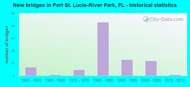
- New bridges - historical statistics
- 71950-1959
- 11960-1969
- 51970-1979
- 431980-1989
- 131990-1999
- 122000-2009
- 12010-2019

- Reconstructed bridges - Historical Statistics
- 21980-1989
- 01990-1999
- 32000-2009
- 62010-2019


- Bridge Condition - Deck
- 1.9%Excellent
- 26.4%Very good
- 58.5%Good
- 5.7%Satisfactory
- 7.5%Fair

- Bridge Condition - Superstructure
- 1.9%Excellent
- 22.6%Very good
- 62.3%Good
- 5.7%Satisfactory
- 7.5%Fair

- Bridge Condition - Substructure
- 1.9%Excellent
- 20.8%Very good
- 69.8%Good
- 7.5%Satisfactory

- Bridge Condition - Channel
- 7.0%Excellent
- 20.9%Very good
- 55.8%Good
- 16.3%Satisfactory

- Bridge Condition - Culverts
- 50.0%Very good
- 33.3%Good
- 16.7%Satisfactory
Find on map >> Show street view
Structure Number: 94014, Location: 0.1MI NOF LK JOSEPHINE DR (Lat: 27.388742, Lng: -81.427669), Route carried "on" structure: County highway , Year Built: 1975, Status: Open, Structure Length: 1.83m (6.00ft), Average Daily Traffic: 200 (year 2020), Truck Traffic: 1%, Average Future Daily Traffic: 347 (year 2042), Design Load: HS 20, Features Intersected: JOSEPHINE CREEK, Facility Carried by Structure: W. JOSEPHINE CT.
Minimum Vertical Clearance: 30+ m (98+ ft), Kilometerpoint: 0.000, Lanes on structure: 1, Owner: County Highway Agency, Approaching Roadway Width: 5.5m (18.0ft), Material/Design: Prestressed concrete, Design/Construction: Tee Beam, Number Of Spans In Main Unit: 1, Length of Maximum Span: 18.3m (60.0ft), Curb or Sidewalk Widths: Left: 0.2m (0.7ft), Right: 0.2m (0.7ft), Curb-To-Curb Width: 4.0m (13.1ft), Out-to-Out Width: 4.9m (16.1ft)
Condition: Deck: Good, Superstructure: Good, Substructure: Good, Channel: Good, Operating Rating: 49.6 metric tons, Method Used To Determine Operating Rating: Load Factor (LF), Inventory Rating: 29.8 metric tons, Method Used To Determine Inventory Rating: Load Factor (LF), Structural Evaluation: Better than present minimum criteria, Deck Geometry: High priority of replacement, Waterway Adequacy: Equal to present desirable criteria, Approach Roadway Alignment: Equal to present desirable criteria, Designated Inspection Frequency: Every 24 months, Inspection Date: June 2020, Deck Structure Type: Concrete Cast-file-Place
Find on map >> Show street view
Structure Number: 94016, Location: 0.6 MI WEST OF US-27 (Lat: 27.387456, Lng: -81.422342), Route carried "on" structure: County highway , Year Built: 1967, Status: Open, Structure Length: 0.68m (2.23ft), Average Daily Traffic: 1,150 (year 2020), Truck Traffic: 13%, Average Future Daily Traffic: 1,995 (year 2042), Design Load: H 20, Features Intersected: JOSEPHINE CREEK WEIR, Facility Carried by Structure: LK JOSEPHINE DR.
Minimum Vertical Clearance: 30+ m (98+ ft), Kilometerpoint: 4.614, Lanes on structure: 2, Owner: County Highway Agency, Approaching Roadway Width: 5.9m (19.4ft), Material/Design: Concrete, Design/Construction: Frame, Number Of Spans In Main Unit: 1, Length of Maximum Span: 6.8m (22.3ft), Curb-To-Curb Width: 7.3m (24.0ft), Out-to-Out Width: 7.9m (25.9ft)
Condition: Deck: Good, Superstructure: Good, Substructure: Good, Channel: Good, Operating Rating: 63.4 metric tons, Method Used To Determine Operating Rating: Load Factor (LF), Inventory Rating: 38.0 metric tons, Method Used To Determine Inventory Rating: Load Factor (LF), Structural Evaluation: Better than present minimum criteria, Deck Geometry: Meets minimum limits, Waterway Adequacy: Equal to present desirable criteria, Approach Roadway Alignment: Better than present minimum criteria, Designated Inspection Frequency: Every 24 months, Underwater Inspection Frequency: Every 24 months, Inspection Date: June 2020, Underwater Inspection Date: May 2020, Deck Structure Type: Concrete Cast-file-Place
Find on map >> Show street view
Structure Number: 890121, Location: 1.5 N of SW KANNER HWY (Lat: 27.124681, Lng: -80.279508), Route carried "on" structure: Interstate 95, Year Built: 1987, Status: Open, Structure Length: 11.98m (39.30ft), Average Daily Traffic: 22,500 (year 2020), Truck Traffic: 6%, Average Future Daily Traffic: 39,038 (year 2042), Design Load: HS 20+Mod, Features Intersected: SR-91 (Fla's.Turnpike)
Minimum Vertical Clearance: 30+ m (98+ ft), Kilometerpoint: 22.278, Lanes on structure: 4, Lanes under structure: 6, Base Highway Network: Yes, Owner: State Highway Agency, Approaching Roadway Width: 19.5m (64.0ft), Skew: 5 degrees, Material/Design: Prestressed concrete, Design/Construction: Stringer/Multi-beam, Number Of Spans In Main Unit: 4, Length of Maximum Span: 33.7m (110.6ft), Curb-To-Curb Width: 19.5m (64.0ft), Out-to-Out Width: 20.4m (66.9ft)
Condition: Deck: Good, Superstructure: Very good, Substructure: Very good, Operating Rating: 58.7 metric tons, Method Used To Determine Operating Rating: Load Factor (LF), Inventory Rating: 51.0 metric tons, Method Used To Determine Inventory Rating: Load Factor (LF), Structural Evaluation: Equal to present desirable criteria, Deck Geometry: Somewhat better than minimum adequacy, Underclear: Somewhat better than minimum adequacy, Approach Roadway Alignment: Equal to present desirable criteria, Designated Inspection Frequency: Every 24 months, Inspection Date: December 2020, Deck Structure Type: Concrete Cast-file-Place
Find on map >> Show street view
Structure Number: 890122, Location: 1.5 Mi N/O SW Kanner Hwy (Lat: 27.125169, Lng: -80.279844), Route carried "on" structure: Interstate 95, Year Built: 1987, Status: Open, Structure Length: 11.88m (38.98ft), Average Daily Traffic: 22,500 (year 2020), Truck Traffic: 6%, Average Future Daily Traffic: 39,038 (year 2042), Design Load: HS 20+Mod, Features Intersected: SR-91 (Fla's. Turnpike)
Minimum Vertical Clearance: 30+ m (98+ ft), Kilometerpoint: 22.339, Lanes on structure: 4, Lanes under structure: 6, Base Highway Network: Yes, Owner: State Highway Agency, Approaching Roadway Width: 16.8m (55.1ft), Skew: 5 degrees, Material/Design: Prestressed concrete, Design/Construction: Stringer/Multi-beam, Number Of Spans In Main Unit: 4, Length of Maximum Span: 34.3m (112.5ft), Curb-To-Curb Width: 19.5m (64.0ft), Out-to-Out Width: 20.4m (66.9ft)
Condition: Deck: Good, Superstructure: Very good, Substructure: Good, Operating Rating: 54.4 metric tons, Method Used To Determine Operating Rating: Load Testing, Inventory Rating: 32.7 metric tons, Method Used To Determine Inventory Rating: Load Testing, Structural Evaluation: Better than present minimum criteria, Deck Geometry: Somewhat better than minimum adequacy, Underclear: Equal to present minimum criteria, Approach Roadway Alignment: Equal to present desirable criteria, Designated Inspection Frequency: Every 24 months, Inspection Date: December 2020, Deck Structure Type: Concrete Cast-file-Place
Find on map >> Show street view
Structure Number: 940049, Location: 1.2MI S PORT ST LUCIE BLV (Lat: 27.262447, Lng: -80.352375), Route carried "on" structure: State highway 91, Year Built: 1958, Year Reconstructed: 1991, Status: Open, Structure Length: 8.99m (29.49ft), Average Daily Traffic: 25,155 (year 2021), Truck Traffic: 18%, Average Future Daily Traffic: 43,643 (year 2042), Design Load: HS 20+Mod, Features Intersected: RIM DITCH CANAL C-24
Minimum Vertical Clearance: 30+ m (98+ ft), Kilometerpoint: 6.560, Lanes on structure: 2, Base Highway Network: Yes, Toll: On toll road, Owner: State Toll Authority, Approaching Roadway Width: 12.8m (42.0ft), Skew: 2 degrees, Material/Design: Steel, Design/Construction: Stringer/Multi-beam, Number Of Spans In Main Unit: 6, Length of Maximum Span: 15.0m (49.2ft), Curb-To-Curb Width: 12.8m (42.0ft), Out-to-Out Width: 13.7m (44.9ft)
Condition: Deck: Satisfactory, Superstructure: Satisfactory, Substructure: Good, Channel: Good, Operating Rating: 70.2 metric tons, Method Used To Determine Operating Rating: Load Factor (LF), Inventory Rating: 42.1 metric tons, Method Used To Determine Inventory Rating: Load Factor (LF), Structural Evaluation: Equal to present minimum criteria, Deck Geometry: Equal to present desirable criteria, Waterway Adequacy: Equal to present minimum criteria, Approach Roadway Alignment: Equal to present desirable criteria, Designated Inspection Frequency: Every 24 months, Underwater Inspection Frequency: Every 24 months, Inspection Date: December 2021, Underwater Inspection Date: December 2021, Deck Structure Type: Concrete Cast-file-Place
Find on map >> Show street view
Structure Number: 940061, Location: 1.6 MI N OF MARTIN CO (Lat: 27.227089, Lng: -80.341600), Route carried "on" structure: State highway 91, Year Built: 1957, Status: Open, Structure Length: 0.91m (2.99ft), Average Daily Traffic: 50,309 (year 2021), Truck Traffic: 18%, Average Future Daily Traffic: 87,286 (year 2042), Design Load: HS 20+Mod, Features Intersected: DRAINAGE DITCH
Minimum Vertical Clearance: 30+ m (98+ ft), Kilometerpoint: 2.519, Lanes on structure: 4, Base Highway Network: Yes, Toll: On toll road, Owner: State Toll Authority, Approaching Roadway Width: 27.1m (88.9ft), Skew: 30 degrees, Material/Design: Concrete, Design/Construction: Culvert, Number Of Spans In Main Unit: 3, Length of Maximum Span: 3.0m (9.8ft)
Condition: Channel: Satisfactory, Culverts: Satisfactory, Operating Rating: 47.9 metric tons, Method Used To Determine Operating Rating: Load Factor (LF), Inventory Rating: 28.8 metric tons, Method Used To Determine Inventory Rating: Load Factor (LF), Structural Evaluation: Equal to present minimum criteria, Waterway Adequacy: Equal to present minimum criteria, Approach Roadway Alignment: Equal to present desirable criteria, Designated Inspection Frequency: Every 24 months, Inspection Date: December 2021
Find on map >> Show street view
Structure Number: 940082, Location: 1.2MI S PORT ST LUCIE RMP (Lat: 27.262503, Lng: -80.352239), Route carried "on" structure: State highway 91, Year Built: 1956, Year Reconstructed: 1991, Status: Open, Structure Length: 8.99m (29.49ft), Average Daily Traffic: 25,155 (year 2021), Truck Traffic: 18%, Average Future Daily Traffic: 43,643 (year 2042), Design Load: HS 20+Mod, Features Intersected: RIM DITCH CANAL C-24
Minimum Vertical Clearance: 30+ m (98+ ft), Kilometerpoint: 6.547, Lanes on structure: 2, Base Highway Network: Yes, Toll: On toll road, Owner: State Toll Authority, Approaching Roadway Width: 13.4m (44.0ft), Skew: 2 degrees, Material/Design: Steel, Design/Construction: Stringer/Multi-beam, Number Of Spans In Main Unit: 6, Length of Maximum Span: 15.1m (49.5ft), Curb-To-Curb Width: 13.4m (44.0ft), Out-to-Out Width: 14.1m (46.3ft)
Condition: Deck: Satisfactory, Superstructure: Good, Substructure: Satisfactory, Channel: Good, Operating Rating: 70.2 metric tons, Method Used To Determine Operating Rating: Load Factor (LF), Inventory Rating: 42.1 metric tons, Method Used To Determine Inventory Rating: Load Factor (LF), Structural Evaluation: Equal to present minimum criteria, Deck Geometry: Superior to present desirable criteria, Waterway Adequacy: Equal to present minimum criteria, Approach Roadway Alignment: Equal to present desirable criteria, Designated Inspection Frequency: Every 24 months, Underwater Inspection Frequency: Every 24 months, Inspection Date: December 2021, Underwater Inspection Date: December 2021, Deck Structure Type: Concrete Cast-file-Place
Find on map >> Show street view
Structure Number: 940104, Location: 0.74 MI N OF ST LUCIE BLV (Lat: 27.293547, Lng: -80.369767), Route carried "on" structure: State highway 91, Year Built: 1956, Status: Open, Structure Length: 0.67m (2.20ft), Average Daily Traffic: 18,800 (year 2021), Truck Traffic: 19%, Average Future Daily Traffic: 32,618 (year 2042), Design Load: HS 20+Mod, Features Intersected: DRAINAGE CANAL
Minimum Vertical Clearance: 30+ m (98+ ft), Kilometerpoint: 10.453, Lanes on structure: 2, Base Highway Network: Yes, Toll: On toll road, Owner: State Toll Authority, Approaching Roadway Width: 12.4m (40.7ft), Material/Design: Concrete, Design/Construction: Culvert, Number Of Spans In Main Unit: 2, Length of Maximum Span: 3.5m (11.5ft)
Condition: Channel: Satisfactory, Culverts: Very good, Operating Rating: 65.7 metric tons, Method Used To Determine Operating Rating: Load Factor (LF), Inventory Rating: 39.4 metric tons, Method Used To Determine Inventory Rating: Load Factor (LF), Structural Evaluation: Equal to present desirable criteria, Waterway Adequacy: Equal to present minimum criteria, Approach Roadway Alignment: Equal to present desirable criteria, Designated Inspection Frequency: Every 24 months, Inspection Date: December 2021
Find on map >> Show street view
Structure Number: 940105, Location: 0.74 MI N OF ST LUCIE BLV (Lat: 27.293667, Lng: -80.369511), Route carried "on" structure: State highway 91, Year Built: 1956, Status: Open, Structure Length: 0.67m (2.20ft), Average Daily Traffic: 18,800 (year 2021), Truck Traffic: 19%, Average Future Daily Traffic: 32,618 (year 2042), Design Load: HS 20+Mod, Features Intersected: DRAINAGE CANAL
Minimum Vertical Clearance: 30+ m (98+ ft), Kilometerpoint: 10.453, Lanes on structure: 2, Base Highway Network: Yes, Toll: On toll road, Owner: State Toll Authority, Approaching Roadway Width: 18.3m (60.0ft), Material/Design: Concrete, Design/Construction: Culvert, Number Of Spans In Main Unit: 2, Length of Maximum Span: 3.4m (11.2ft)
Condition: Channel: Satisfactory, Culverts: Very good, Operating Rating: 65.7 metric tons, Method Used To Determine Operating Rating: Load Factor (LF), Inventory Rating: 39.4 metric tons, Method Used To Determine Inventory Rating: Load Factor (LF), Structural Evaluation: Equal to present desirable criteria, Waterway Adequacy: Equal to present minimum criteria, Approach Roadway Alignment: Equal to present desirable criteria, Designated Inspection Frequency: Every 24 months, Inspection Date: December 2021
Find on map >> Show street view
Structure Number: 940106, Location: 2.85 MI SOUTH OF SR-712 (Lat: 27.337850, Lng: -80.374264), Route carried "on" structure: State highway 91, Year Built: 1956, Status: Open, Structure Length: 0.69m (2.26ft), Average Daily Traffic: 37,600 (year 2021), Truck Traffic: 19%, Average Future Daily Traffic: 65,236 (year 2042), Design Load: HS 20+Mod, Features Intersected: DRAINAGE DITCH
Minimum Vertical Clearance: 30+ m (98+ ft), Kilometerpoint: 15.393, Lanes on structure: 4, Base Highway Network: Yes, Toll: On toll road, Owner: State Toll Authority, Approaching Roadway Width: 25.2m (82.7ft), Skew: 20 degrees, Material/Design: Concrete, Design/Construction: Culvert, Number Of Spans In Main Unit: 2, Length of Maximum Span: 3.5m (11.5ft)
Condition: Channel: Good, Culverts: Very good, Operating Rating: 65.7 metric tons, Method Used To Determine Operating Rating: Load Factor (LF), Inventory Rating: 39.4 metric tons, Method Used To Determine Inventory Rating: Load Factor (LF), Structural Evaluation: Equal to present desirable criteria, Waterway Adequacy: Equal to present minimum criteria, Approach Roadway Alignment: Equal to present desirable criteria, Designated Inspection Frequency: Every 24 months, Inspection Date: December 2021
Find on map >> Show street view
Structure Number: 940108, Location: 4.3 m N of Martin Co Line (Lat: 27.264383, Lng: -80.422308), Route carried "on" structure: Interstate 95, Year Built: 1982, Year Reconstructed: 2017, Status: Open, Structure Length: 6.95m (22.80ft), Average Daily Traffic: 40,250 (year 2020), Truck Traffic: 12%, Average Future Daily Traffic: 69,834 (year 2042), Design Load: HS 20+Mod, Features Intersected: Gatlin Blvd
Minimum Vertical Clearance: 30+ m (98+ ft), Kilometerpoint: 6.922, Lanes on structure: 3, Lanes under structure: 6, Base Highway Network: Yes, Owner: State Highway Agency, Approaching Roadway Width: 17.3m (56.8ft), Skew: 1 degrees, Material/Design: Prestressed concrete, Design/Construction: Stringer/Multi-beam, Number Of Spans In Main Unit: 4, Length of Maximum Span: 24.5m (80.4ft), Curb-To-Curb Width: 17.3m (56.8ft), Out-to-Out Width: 18.3m (60.0ft)
Condition: Deck: Very good, Superstructure: Satisfactory, Substructure: Very good, Operating Rating: 50.6 metric tons, Method Used To Determine Operating Rating: Load and Resistance Factor (LRFR), Inventory Rating: 37.6 metric tons, Method Used To Determine Inventory Rating: Load and Resistance Factor (LRFR), Structural Evaluation: Equal to present minimum criteria, Deck Geometry: Better than present minimum criteria, Underclear: Equal to present minimum criteria, Approach Roadway Alignment: Equal to present desirable criteria, Designated Inspection Frequency: Every 24 months, Inspection Date: November 2020, Deck Structure Type: Concrete Cast-file-Place
Find on map >> Show street view
Structure Number: 940109, Location: 4.3 m N of Martin Co Line (Lat: 27.264372, Lng: -80.421906), Route carried "on" structure: Interstate 95, Year Built: 1982, Year Reconstructed: 2017, Status: Open, Structure Length: 6.95m (22.80ft), Average Daily Traffic: 40,250 (year 2020), Truck Traffic: 12%, Average Future Daily Traffic: 69,834 (year 2042), Design Load: HS 20+Mod, Features Intersected: Gatlin Blvd
Minimum Vertical Clearance: 30+ m (98+ ft), Kilometerpoint: 6.919, Lanes on structure: 3, Lanes under structure: 6, Base Highway Network: Yes, Owner: State Highway Agency, Approaching Roadway Width: 17.3m (56.8ft), Skew: 1 degrees, Material/Design: Prestressed concrete, Design/Construction: Stringer/Multi-beam, Number Of Spans In Main Unit: 4, Length of Maximum Span: 24.5m (80.4ft), Curb-To-Curb Width: 17.3m (56.8ft), Out-to-Out Width: 18.3m (60.0ft)
Condition: Deck: Very good, Superstructure: Good, Substructure: Very good, Operating Rating: 50.6 metric tons, Method Used To Determine Operating Rating: Load and Resistance Factor (LRFR), Inventory Rating: 37.6 metric tons, Method Used To Determine Inventory Rating: Load and Resistance Factor (LRFR), Structural Evaluation: Better than present minimum criteria, Deck Geometry: Better than present minimum criteria, Underclear: Equal to present minimum criteria, Approach Roadway Alignment: Equal to present desirable criteria, Designated Inspection Frequency: Every 24 months, Inspection Date: November 2020, Deck Structure Type: Concrete Cast-file-Place
Find on map >> Show street view
Structure Number: 940111, Location: I-95 over Midway Road (Lat: 27.374525, Lng: -80.408878), Route carried "on" structure: Interstate 95, Year Built: 1981, Year Reconstructed: 2017, Status: Open, Structure Length: 7.39m (24.25ft), Average Daily Traffic: 30,193 (year 2020), Truck Traffic: 17%, Average Future Daily Traffic: 52,385 (year 2042), Design Load: HS 20+Mod, Features Intersected: CR 712 (Midway Road)
Minimum Vertical Clearance: 30+ m (98+ ft), Kilometerpoint: 19.529, Lanes on structure: 3, Lanes under structure: 4, Base Highway Network: Yes, Owner: State Highway Agency, Approaching Roadway Width: 17.3m (56.8ft), Skew: 2 degrees, Material/Design: Prestressed concrete, Design/Construction: Stringer/Multi-beam, Number Of Spans In Main Unit: 4, Length of Maximum Span: 25.1m (82.3ft), Curb-To-Curb Width: 17.3m (56.8ft), Out-to-Out Width: 17.9m (58.7ft)
Condition: Deck: Very good, Superstructure: Good, Substructure: Good, Operating Rating: 47.7 metric tons, Method Used To Determine Operating Rating: Load Factor (LF), Inventory Rating: 29.0 metric tons, Method Used To Determine Inventory Rating: Load Factor (LF), Structural Evaluation: Better than present minimum criteria, Deck Geometry: Better than present minimum criteria, Underclear: Better than present minimum criteria, Approach Roadway Alignment: Equal to present desirable criteria, Designated Inspection Frequency: Every 24 months, Inspection Date: November 2020, Deck Structure Type: Concrete Cast-file-Place
Find on map >> Show street view
Structure Number: 940112, Location: I-95 over Midway Road (Lat: 27.374811, Lng: -80.410214), Route carried "on" structure: Interstate 95, Year Built: 1981, Year Reconstructed: 2017, Status: Open, Structure Length: 7.39m (24.25ft), Average Daily Traffic: 30,193 (year 2020), Truck Traffic: 17%, Average Future Daily Traffic: 52,385 (year 2042), Design Load: HS 20+Mod, Features Intersected: CR-712 Midway Road
Minimum Vertical Clearance: 30+ m (98+ ft), Kilometerpoint: 19.508, Lanes on structure: 3, Lanes under structure: 4, Base Highway Network: Yes, Owner: State Highway Agency, Approaching Roadway Width: 17.4m (57.1ft), Skew: 2 degrees, Material/Design: Prestressed concrete, Design/Construction: Stringer/Multi-beam, Number Of Spans In Main Unit: 4, Length of Maximum Span: 25.1m (82.3ft), Curb-To-Curb Width: 17.4m (57.1ft), Out-to-Out Width: 18.3m (60.0ft)
Condition: Deck: Very good, Superstructure: Good, Substructure: Very good, Operating Rating: 47.7 metric tons, Method Used To Determine Operating Rating: Load Factor (LF), Inventory Rating: 29.0 metric tons, Method Used To Determine Inventory Rating: Load Factor (LF), Structural Evaluation: Better than present minimum criteria, Deck Geometry: Better than present minimum criteria, Underclear: Better than present minimum criteria, Approach Roadway Alignment: Equal to present desirable criteria, Designated Inspection Frequency: Every 24 months, Inspection Date: November 2020, Deck Structure Type: Concrete Cast-file-Place
Find on map >> Show street view
Structure Number: 940113, Location: 2 mi. N of Gatlin Blvd. (Lat: 27.289314, Lng: -80.421086), Route carried "on" structure: Interstate 95, Year Built: 1982, Year Reconstructed: 2008, Status: Open, Structure Length: 12.68m (41.60ft), Average Daily Traffic: 40,250 (year 2020), Truck Traffic: 12%, Average Future Daily Traffic: 69,834 (year 2042), Design Load: HL 93, Features Intersected: Galiano Rd. & C-24 Canal
Minimum Vertical Clearance: 30+ m (98+ ft), Kilometerpoint: 9.806, Lanes on structure: 4, Lanes under structure: 2, Base Highway Network: Yes, Owner: State Highway Agency, Approaching Roadway Width: 20.7m (67.9ft), Skew: 1 degrees, Material/Design: Prestressed concrete, Design/Construction: Stringer/Multi-beam, Number Of Spans In Main Unit: 6, Length of Maximum Span: 25.8m (84.6ft), Curb-To-Curb Width: 20.7m (67.9ft), Out-to-Out Width: 21.7m (71.2ft)
Condition: Deck: Good, Superstructure: Very good, Substructure: Good, Channel: Good, Operating Rating: 38.6 metric tons, Method Used To Determine Operating Rating: Load and Resistance Factor (LRFR), Inventory Rating: 34.3 metric tons, Method Used To Determine Inventory Rating: Load and Resistance Factor (LRFR), Structural Evaluation: Better than present minimum criteria, Deck Geometry: Equal to present minimum criteria, Underclear: Superior to present desirable criteria, Waterway Adequacy: Equal to present desirable criteria, Approach Roadway Alignment: Equal to present desirable criteria, Designated Inspection Frequency: Every 24 months, Underwater Inspection Frequency: Every 24 months, Inspection Date: September 2020, Underwater Inspection Date: September 2020, Deck Structure Type: Concrete Cast-file-Place
Find on map >> Show street view
Structure Number: 940114, Location: 2 mi. N of Gatlin Blvd. (Lat: 27.289044, Lng: -80.420811), Route carried "on" structure: Interstate 95, Year Built: 1982, Year Reconstructed: 2008, Status: Open, Structure Length: 12.68m (41.60ft), Average Daily Traffic: 40,250 (year 2020), Truck Traffic: 12%, Average Future Daily Traffic: 69,834 (year 2042), Design Load: HL 93, Features Intersected: Galiano Rd & C-24 Canal
Minimum Vertical Clearance: 30+ m (98+ ft), Kilometerpoint: 9.806, Lanes on structure: 3, Lanes under structure: 2, Base Highway Network: Yes, Owner: State Highway Agency, Approaching Roadway Width: 17.1m (56.1ft), Skew: 1 degrees, Material/Design: Prestressed concrete, Design/Construction: Stringer/Multi-beam, Number Of Spans In Main Unit: 6, Length of Maximum Span: 25.8m (84.6ft), Curb-To-Curb Width: 17.1m (56.1ft), Out-to-Out Width: 18.0m (59.1ft)
Condition: Deck: Very good, Superstructure: Good, Substructure: Good, Channel: Good, Operating Rating: 38.6 metric tons, Method Used To Determine Operating Rating: Load and Resistance Factor (LRFR), Inventory Rating: 34.3 metric tons, Method Used To Determine Inventory Rating: Load and Resistance Factor (LRFR), Structural Evaluation: Better than present minimum criteria, Deck Geometry: Equal to present minimum criteria, Underclear: Superior to present desirable criteria, Waterway Adequacy: Superior to present desirable criteria, Approach Roadway Alignment: Equal to present desirable criteria, Designated Inspection Frequency: Every 24 months, Underwater Inspection Frequency: Every 24 months, Inspection Date: September 2020, Underwater Inspection Date: September 2020, Deck Structure Type: Concrete Cast-file-Place
Find on map >> Show street view
Structure Number: 940115, Location: 0.75 Mile S of Midway Rd. (Lat: 27.354892, Lng: -80.414247), Route carried "on" structure: Interstate 95, Year Built: 1982, Year Reconstructed: 2018, Status: Open, Structure Length: 14.55m (47.74ft), Average Daily Traffic: 30,193 (year 2020), Truck Traffic: 17%, Average Future Daily Traffic: 52,385 (year 2042), Design Load: HS 20+Mod, Features Intersected: CR-709 & FECRR
Minimum Vertical Clearance: 30+ m (98+ ft), Kilometerpoint: 17.260, Lanes on structure: 3, Lanes under structure: 2, Base Highway Network: Yes, Owner: State Highway Agency, Approaching Roadway Width: 17.4m (57.1ft), Skew: 4 degrees, Material/Design: Prestressed concrete, Design/Construction: Stringer/Multi-beam, Number Of Spans In Main Unit: 6, Length of Maximum Span: 38.1m (125.0ft), Curb-To-Curb Width: 17.1m (56.1ft), Out-to-Out Width: 17.9m (58.7ft)
Condition: Deck: Very good, Superstructure: Good, Substructure: Good, Operating Rating: 66.9 metric tons, Method Used To Determine Operating Rating: Load Factor (LF), Inventory Rating: 36.4 metric tons, Method Used To Determine Inventory Rating: Load Factor (LF), Structural Evaluation: Better than present minimum criteria, Deck Geometry: Equal to present minimum criteria, Underclear: Superior to present desirable criteria, Approach Roadway Alignment: Equal to present desirable criteria, Designated Inspection Frequency: Every 24 months, Inspection Date: November 2020, Deck Structure Type: Concrete Cast-file-Place
Find on map >> Show street view
Structure Number: 940116, Location: 1.3 Mile S of Midway Rd. (Lat: 27.355200, Lng: -80.413875), Route carried "on" structure: Interstate 95, Year Built: 1982, Year Reconstructed: 2018, Status: Open, Structure Length: 14.55m (47.74ft), Average Daily Traffic: 30,193 (year 2020), Truck Traffic: 17%, Average Future Daily Traffic: 52,385 (year 2042), Design Load: HS 20+Mod, Features Intersected: CR 709 & FECRR
Minimum Vertical Clearance: 30+ m (98+ ft), Kilometerpoint: 17.297, Lanes on structure: 3, Lanes under structure: 2, Base Highway Network: Yes, Owner: State Highway Agency, Approaching Roadway Width: 17.0m (55.8ft), Skew: 4 degrees, Material/Design: Prestressed concrete, Design/Construction: Stringer/Multi-beam, Number Of Spans In Main Unit: 6, Length of Maximum Span: 38.1m (125.0ft), Curb-To-Curb Width: 17.1m (56.1ft), Out-to-Out Width: 17.9m (58.7ft)
Condition: Deck: Very good, Superstructure: Good, Substructure: Good, Operating Rating: 67.3 metric tons, Method Used To Determine Operating Rating: Load Factor (LF), Inventory Rating: 37.3 metric tons, Method Used To Determine Inventory Rating: Load Factor (LF), Structural Evaluation: Better than present minimum criteria, Deck Geometry: Equal to present minimum criteria, Underclear: Superior to present desirable criteria, Approach Roadway Alignment: Equal to present desirable criteria, Designated Inspection Frequency: Every 24 months, Inspection Date: November 2020, Deck Structure Type: Concrete Cast-file-Place
Find on map >> Show street view
Structure Number: 940121, Location: 0.2 MI N OF ST LUCIE BLVD (Lat: 27.276328, Lng: -80.360075), Route carried "on" structure: Ramp State highway 91, Year Built: 1975, Status: Open, Structure Length: 6.83m (22.41ft), Average Daily Traffic: 1,700 (year 2021), Truck Traffic: 19%, Average Future Daily Traffic: 2,950 (year 2042), Design Load: HS 20+Mod, Features Intersected: SR 91 TPK (ST LUCIE INT)
Minimum Vertical Clearance: 30+ m (98+ ft), Kilometerpoint: 0.449, Lanes on structure: 2, Lanes under structure: 5, Toll: On toll road, Owner: State Toll Authority, Approaching Roadway Width: 12.8m (42.0ft), Skew: 30 degrees, Material/Design: Prestressed concrete, Design/Construction: Stringer/Multi-beam, Number Of Spans In Main Unit: 4, Length of Maximum Span: 24.1m (79.1ft), Curb-To-Curb Width: 10.9m (35.8ft), Out-to-Out Width: 14.3m (46.9ft)
Condition: Deck: Good, Superstructure: Very good, Substructure: Good, Operating Rating: 81.7 metric tons, Method Used To Determine Operating Rating: Load Factor (LF), Inventory Rating: 49.1 metric tons, Method Used To Determine Inventory Rating: Load Factor (LF), Structural Evaluation: Better than present minimum criteria, Deck Geometry: Better than present minimum criteria, Underclear: Somewhat better than minimum adequacy, Approach Roadway Alignment: Equal to present minimum criteria, Designated Inspection Frequency: Every 24 months, Inspection Date: December 2021, Deck Structure Type: Concrete Cast-file-Place
Find on map >> Show street view
Structure Number: 940139, Location: 1.8mi. East of SR-91 (Lat: 27.271758, Lng: -80.324603), Route carried "on" structure: State highway 716, Year Built: 1991, Status: Open, Structure Length: 13.29m (43.60ft), Average Daily Traffic: 24,500 (year 2020), Truck Traffic: 5%, Average Future Daily Traffic: 42,508 (year 2042), Design Load: HS 20, Features Intersected: Long Creek, Facility Carried by Structure: EB St. Lucie Blvd.
Minimum Vertical Clearance: 30+ m (98+ ft), Kilometerpoint: 11.262, Lanes on structure: 3, Base Highway Network: Yes, Owner: State Highway Agency, Approaching Roadway Width: 13.5m (44.3ft), Skew: 2 degrees, Material/Design: Prestressed concrete, Design/Construction: Stringer/Multi-beam, Number Of Spans In Main Unit: 6, Length of Maximum Span: 24.1m (79.1ft), Curb or Sidewalk Widths: Left: 0.0m, Right: 1.5m (4.9ft), Curb-To-Curb Width: 13.6m (44.6ft), Out-to-Out Width: 16.2m (53.1ft)
Condition: Deck: Very good, Superstructure: Very good, Substructure: Satisfactory, Channel: Very good, Operating Rating: 57.1 metric tons, Method Used To Determine Operating Rating: Load Factor (LF), Inventory Rating: 39.9 metric tons, Method Used To Determine Inventory Rating: Load Factor (LF), Structural Evaluation: Equal to present minimum criteria, Deck Geometry: Somewhat better than minimum adequacy, Waterway Adequacy: Superior to present desirable criteria, Approach Roadway Alignment: Equal to present desirable criteria, Designated Inspection Frequency: Every 24 months, Underwater Inspection Frequency: Every 24 months, Inspection Date: October 2020, Underwater Inspection Date: October 2020, Deck Structure Type: Concrete Cast-file-Place
Find on map >> Show street view
Structure Number: 94014, Location: 2mi. East of SR-91 (Lat: 27.271708, Lng: -80.322222), Route carried "on" structure: State highway 716, Year Built: 1991, Status: Open, Structure Length: 12.71m (41.70ft), Average Daily Traffic: 24,500 (year 2020), Truck Traffic: 5%, Average Future Daily Traffic: 42,508 (year 2042), Design Load: HS 20+Mod, Features Intersected: N. Fork St. Lucie River, Facility Carried by Structure: EB Prt St Lucie Bd
Minimum Vertical Clearance: 30+ m (98+ ft), Kilometerpoint: 11.502, Lanes on structure: 3, Base Highway Network: Yes, Owner: State Highway Agency, Approaching Roadway Width: 13.6m (44.6ft), Navigation Control: Yes ( Vertical Clearance: 5.6m (18.4ft), Horizontal Clearance: 23.0m (75.5ft)), Material/Design: Prestressed concrete, Design/Construction: Stringer/Multi-beam, Number Of Spans In Main Unit: 5, Length of Maximum Span: 27.4m (89.9ft), Curb or Sidewalk Widths: Left: 0.0m, Right: 1.5m (4.9ft), Curb-To-Curb Width: 15.1m (49.5ft), Out-to-Out Width: 16.2m (53.1ft)
Condition: Deck: Very good, Superstructure: Good, Substructure: Good, Channel: Good, Operating Rating: 56.2 metric tons, Method Used To Determine Operating Rating: Load Factor (LF), Inventory Rating: 48.0 metric tons, Method Used To Determine Inventory Rating: Load Factor (LF), Structural Evaluation: Better than present minimum criteria, Deck Geometry: Equal to present minimum criteria, Waterway Adequacy: Superior to present desirable criteria, Approach Roadway Alignment: Equal to present desirable criteria, Designated Inspection Frequency: Every 24 months, Underwater Inspection Frequency: Every 24 months, Inspection Date: October 2020, Underwater Inspection Date: October 2020, Deck Structure Type: Concrete Cast-file-Place
Find on map >> Show street view
Structure Number: 940142, Location: Port St Lucie / FL TPK. (Lat: 27.272844, Lng: -80.358422), Route carried "on" structure: State highway 716, Year Built: 1995, Status: Open, Structure Length: 7.93m (26.02ft), Average Daily Traffic: 51,000 (year 2018), Truck Traffic: 5%, Average Future Daily Traffic: 88,485 (year 2040), Design Load: HS 20, Features Intersected: SR-91 (Florida Turnpike), Facility Carried by Structure: Port St. Lucie Bld
Minimum Vertical Clearance: 30+ m (98+ ft), Kilometerpoint: 7.936, Lanes on structure: 6, Lanes under structure: 6, Base Highway Network: Yes, Owner: State Highway Agency, Approaching Roadway Width: 30.0m (98.4ft), Skew: 20 degrees, Material/Design: Prestressed concrete, Design/Construction: Stringer/Multi-beam, Number Of Spans In Main Unit: 3, Length of Maximum Span: 26.5m (86.9ft), Curb or Sidewalk Widths: Left: 1.5m (4.9ft), Right: 1.5m (4.9ft), Curb-To-Curb Width: 33.7m (110.6ft), Out-to-Out Width: 35.2m (115.5ft)
Condition: Deck: Good, Superstructure: Good, Substructure: Good, Operating Rating: 87.9 metric tons, Method Used To Determine Operating Rating: Load Factor (LF), Inventory Rating: 52.7 metric tons, Method Used To Determine Inventory Rating: Load Factor (LF), Structural Evaluation: Better than present minimum criteria, Deck Geometry: Superior to present desirable criteria, Underclear: High priority of corrective action, Approach Roadway Alignment: Equal to present desirable criteria, Designated Inspection Frequency: Every 24 months, Inspection Date: January 2021, Deck Structure Type: Concrete Cast-file-Place
Find on map >> Show street view
Structure Number: 940144, Location: 1.8mi. East of SR-91 (Lat: 27.271875, Lng: -80.324603), Route carried "on" structure: State highway 716, Year Built: 1993, Status: Open, Structure Length: 12.04m (39.50ft), Average Daily Traffic: 24,500 (year 2020), Truck Traffic: 5%, Average Future Daily Traffic: 42,508 (year 2042), Design Load: HS 20, Features Intersected: Long Creek, Facility Carried by Structure: WB St. Lucie Blvd.
Minimum Vertical Clearance: 30+ m (98+ ft), Kilometerpoint: 11.262, Lanes on structure: 3, Base Highway Network: Yes, Owner: State Highway Agency, Approaching Roadway Width: 13.5m (44.3ft), Skew: 2 degrees, Material/Design: Prestressed concrete, Design/Construction: Stringer/Multi-beam, Number Of Spans In Main Unit: 5, Length of Maximum Span: 24.1m (79.1ft), Curb or Sidewalk Widths: Left: 1.5m (4.9ft), Right: 0.0m, Curb-To-Curb Width: 13.6m (44.6ft), Out-to-Out Width: 16.2m (53.1ft)
Condition: Deck: Good, Superstructure: Very good, Substructure: Good, Channel: Very good, Operating Rating: 67.7 metric tons, Method Used To Determine Operating Rating: Load Factor (LF), Inventory Rating: 40.6 metric tons, Method Used To Determine Inventory Rating: Load Factor (LF), Structural Evaluation: Better than present minimum criteria, Deck Geometry: Somewhat better than minimum adequacy, Waterway Adequacy: Superior to present desirable criteria, Approach Roadway Alignment: Equal to present desirable criteria, Designated Inspection Frequency: Every 24 months, Underwater Inspection Frequency: Every 24 months, Inspection Date: October 2020, Underwater Inspection Date: October 2020, Deck Structure Type: Concrete Cast-file-Place
Find on map >> Show street view
Structure Number: 940145, Location: 2mi. East of SR-91 (Lat: 27.271819, Lng: -80.322222), Route carried "on" structure: State highway 716, Year Built: 1993, Status: Open, Structure Length: 12.71m (41.70ft), Average Daily Traffic: 24,500 (year 2020), Truck Traffic: 5%, Average Future Daily Traffic: 42,508 (year 2042), Design Load: HS 20, Features Intersected: N Fork St. Lucie River, Facility Carried by Structure: WB Prt St Lucie Bd
Minimum Vertical Clearance: 30+ m (98+ ft), Kilometerpoint: 11.502, Lanes on structure: 3, Base Highway Network: Yes, Owner: State Highway Agency, Approaching Roadway Width: 13.6m (44.6ft), Navigation Control: Yes ( Vertical Clearance: 5.6m (18.4ft), Horizontal Clearance: 23.0m (75.5ft)), Material/Design: Prestressed concrete, Design/Construction: Stringer/Multi-beam, Number Of Spans In Main Unit: 5, Length of Maximum Span: 27.4m (89.9ft), Curb or Sidewalk Widths: Left: 1.5m (4.9ft), Right: 0.0m, Curb-To-Curb Width: 15.1m (49.5ft), Out-to-Out Width: 16.2m (53.1ft)
Condition: Deck: Very good, Superstructure: Very good, Substructure: Satisfactory, Channel: Very good, Operating Rating: 80.7 metric tons, Method Used To Determine Operating Rating: Load Factor (LF), Inventory Rating: 48.0 metric tons, Method Used To Determine Inventory Rating: Load Factor (LF), Structural Evaluation: Equal to present minimum criteria, Deck Geometry: Equal to present minimum criteria, Waterway Adequacy: Superior to present desirable criteria, Approach Roadway Alignment: Equal to present desirable criteria, Designated Inspection Frequency: Every 24 months, Underwater Inspection Frequency: Every 24 months, Inspection Date: October 2020, Underwater Inspection Date: October 2020, Deck Structure Type: Concrete Cast-file-Place
Find on map >> Show street view
Structure Number: 94016, Location: Becker Rd/I-95 interchge (Lat: 27.209750, Lng: -80.400528), Route carried "on" structure: County highway , Year Built: 2009, Status: Open, Structure Length: 7.56m (24.80ft), Average Daily Traffic: 1,800 (year 2021), Truck Traffic: 12%, Average Future Daily Traffic: 3,123 (year 2042), Design Load: HL 93, Features Intersected: I-95 (S.R. 9), Facility Carried by Structure: Becker Road
Minimum Vertical Clearance: 30+ m (98+ ft), Kilometerpoint: 1.379, Lanes on structure: 10, Lanes under structure: 6, Owner: City or Municipal Highway Agency, Approaching Roadway Width: 41.5m (136.2ft), Skew: 20 degrees, Material/Design: Prestressed concrete, Design/Construction: Stringer/Multi-beam, Number Of Spans In Main Unit: 2, Length of Maximum Span: 37.8m (124.0ft), Curb or Sidewalk Widths: Left: 2.5m (8.2ft), Right: 2.5m (8.2ft), Curb-To-Curb Width: 40.0m (131.2ft), Out-to-Out Width: 47.9m (157.2ft)
Condition: Deck: Very good, Superstructure: Very good, Substructure: Very good, Operating Rating: 46.0 metric tons, Method Used To Determine Operating Rating: Load and Resistance Factor (LRFR), Inventory Rating: 41.7 metric tons, Method Used To Determine Inventory Rating: Load and Resistance Factor (LRFR), Structural Evaluation: Equal to present desirable criteria, Deck Geometry: Somewhat better than minimum adequacy, Underclear: Equal to present minimum criteria, Approach Roadway Alignment: Equal to present desirable criteria, Designated Inspection Frequency: Every 24 months, Inspection Date: Febuary 2021, Deck Structure Type: Concrete Cast-file-Place
Find on map >> Show street view
Structure Number: 940161, Location: Crosstown Pkwy/I-95 (Lat: 27.294222, Lng: -80.417583), Route carried "on" structure: County highway , Year Built: 2009, Status: Open, Structure Length: 8.05m (26.41ft), Average Daily Traffic: 17,500 (year 2021), Truck Traffic: 5%, Average Future Daily Traffic: 30,363 (year 2042), Design Load: HL 93, Features Intersected: I-95 (SR-9), Facility Carried by Structure: Crosstown Parkway
Minimum Vertical Clearance: 30+ m (98+ ft), Kilometerpoint: 2.052, Lanes on structure: 10, Lanes under structure: 6, Owner: City or Municipal Highway Agency, Approaching Roadway Width: 40.0m (131.2ft), Skew: 22 degrees, Material/Design: Prestressed concrete, Design/Construction: Stringer/Multi-beam, Number Of Spans In Main Unit: 2, Length of Maximum Span: 40.2m (131.9ft), Curb or Sidewalk Widths: Left: 1.8m (5.9ft), Right: 2.4m (7.9ft), Curb-To-Curb Width: 40.0m (131.2ft), Out-to-Out Width: 47.9m (157.2ft)
Condition: Deck: Very good, Superstructure: Very good, Substructure: Very good, Operating Rating: 49.4 metric tons, Method Used To Determine Operating Rating: Load and Resistance Factor (LRFR), Inventory Rating: 45.1 metric tons, Method Used To Determine Inventory Rating: Load and Resistance Factor (LRFR), Structural Evaluation: Equal to present desirable criteria, Deck Geometry: Somewhat better than minimum adequacy, Underclear: Equal to present minimum criteria, Approach Roadway Alignment: Equal to present desirable criteria, Designated Inspection Frequency: Every 24 months, Inspection Date: Febuary 2021, Deck Structure Type: Concrete Cast-file-Place
Find on map >> Show street view
Structure Number: 941001, Location: 0.3 Mi. W of SE Bosko Dr (Lat: 27.209478, Lng: -80.333611), Route carried "on" structure: County highway , Year Built: 2007, Status: Open, Structure Length: 6.00m (19.69ft), Average Daily Traffic: 8,800 (year 2020), Truck Traffic: 5%, Average Future Daily Traffic: 15,268 (year 2042), Design Load: HL 93, Features Intersected: Florida Turnpike (SR-91), Facility Carried by Structure: Becker Rd.
Minimum Vertical Clearance: 30+ m (98+ ft), Kilometerpoint: 6.532, Lanes on structure: 5, Lanes under structure: 5, Owner: City or Municipal Highway Agency, Approaching Roadway Width: 18.8m (61.7ft), Skew: 22 degrees, Material/Design: Prestressed concrete, Design/Construction: Stringer/Multi-beam, Number Of Spans In Main Unit: 2, Length of Maximum Span: 30.0m (98.4ft), Curb or Sidewalk Widths: Left: 1.5m (4.9ft), Right: 1.5m (4.9ft), Curb-To-Curb Width: 22.1m (72.5ft), Out-to-Out Width: 29.3m (96.1ft)
Condition: Deck: Good, Superstructure: Good, Substructure: Very good, Operating Rating: 34.9 metric tons, Method Used To Determine Operating Rating: Load and Resistance Factor (LRFR), Inventory Rating: 33.9 metric tons, Method Used To Determine Inventory Rating: Load and Resistance Factor (LRFR), Structural Evaluation: Better than present minimum criteria, Deck Geometry: Somewhat better than minimum adequacy, Approach Roadway Alignment: Equal to present desirable criteria, Designated Inspection Frequency: Every 24 months, Inspection Date: October 2020, Deck Structure Type: Concrete Cast-file-Place
Find on map >> Show street view
Structure Number: 944008, Location: 0.5MI Nof PT ST LUCIE BLD (Lat: 27.280372, Lng: -80.331792), Route carried "on" structure: City street , Year Built: 1970, Status: Open, Structure Length: 3.20m (10.50ft), Average Daily Traffic: 6,000 (year 2021), Truck Traffic: 5%, Average Future Daily Traffic: 7,200 (year 2042), Design Load: HS 20, Features Intersected: ELKCAM WATERWAY, Facility Carried by Structure: FLORESTA DR
Minimum Vertical Clearance: 30+ m (98+ ft), Kilometerpoint: 1.876, Lanes on structure: 2, Owner: City or Municipal Highway Agency, Approaching Roadway Width: 7.6m (24.9ft), Material/Design: Prestressed concrete, Design/Construction: Slab, Number Of Spans In Main Unit: 3, Length of Maximum Span: 10.7m (35.1ft), Curb-To-Curb Width: 7.9m (25.9ft), Out-to-Out Width: 9.2m (30.2ft)
Condition: Deck: Good, Superstructure: Good, Substructure: Good, Channel: Good, Operating Rating: 42.6 metric tons, Method Used To Determine Operating Rating: Allowable Stress (AS), Inventory Rating: 37.2 metric tons, Method Used To Determine Inventory Rating: Allowable Stress (AS), Structural Evaluation: Better than present minimum criteria, Deck Geometry: High priority of replacement, Waterway Adequacy: Better than present minimum criteria, Approach Roadway Alignment: Better than present minimum criteria, Designated Inspection Frequency: Every 24 months, Underwater Inspection Frequency: Every 24 months, Inspection Date: January 2021, Underwater Inspection Date: January 2021, Deck Structure Type: Concrete Precast Panels, Wearing Surface/Protective System: Wearing Surface: Bituminous
Find on map >> Show street view
Structure Number: 944011, Location: 0.8 MI W OF US-1 (Lat: 27.323811, Lng: -80.335050), Route carried "on" structure: County highway , Year Built: 1994, Status: Open, Structure Length: 6.31m (20.70ft), Average Daily Traffic: 24,900 (year 2021), Truck Traffic: 5%, Average Future Daily Traffic: 43,202 (year 2042), Design Load: HS 20, Features Intersected: ST. LUCIE RIVER, Facility Carried by Structure: PRIMA VISTA BLVD.
Minimum Vertical Clearance: 30+ m (98+ ft), Kilometerpoint: 2.256, Lanes on structure: 4, Base Highway Network: Yes, Owner: County Highway Agency, Approaching Roadway Width: 19.6m (64.3ft), Navigation Control: Yes ( Vertical Clearance: 3.9m (12.8ft), Horizontal Clearance: 17.6m (57.7ft)), Material/Design: Prestressed concrete, Design/Construction: Stringer/Multi-beam, Number Of Spans In Main Unit: 3, Length of Maximum Span: 22.3m (73.2ft), Curb or Sidewalk Widths: Left: 0.0m, Right: 2.0m (6.6ft), Curb-To-Curb Width: 20.7m (67.9ft), Out-to-Out Width: 23.6m (77.4ft)
Condition: Deck: Good, Superstructure: Good, Substructure: Good, Channel: Good, Inventory Rating: 54.0 metric tons, Method Used To Determine Inventory Rating: Load Factor (LF), Structural Evaluation: Better than present minimum criteria, Deck Geometry: Superior to present desirable criteria, Waterway Adequacy: Better than present minimum criteria, Approach Roadway Alignment: Equal to present desirable criteria, Designated Inspection Frequency: Every 24 months, Underwater Inspection Frequency: Every 24 months, Inspection Date: January 2021, Underwater Inspection Date: January 2021, Deck Structure Type: Concrete Cast-file-Place
Find on map >> Show street view
Structure Number: 944012, Location: 0.9 MI W OF US-1 (Lat: 27.325003, Lng: -80.333233), Route carried "on" structure: County highway , Year Built: 1994, Status: Open, Structure Length: 2.26m (7.41ft), Average Daily Traffic: 24,900 (year 2021), Truck Traffic: 5%, Average Future Daily Traffic: 43,202 (year 2042), Design Load: HS 20, Features Intersected: FORK OF ST. LUCIE RIVER, Facility Carried by Structure: PRIMA VISTA BLVD.
Minimum Vertical Clearance: 30.45m (99.90ft), Kilometerpoint: 2.062, Lanes on structure: 4, Base Highway Network: Yes, Owner: County Highway Agency, Approaching Roadway Width: 19.7m (64.6ft), Material/Design: Concrete continuous, Design/Construction: Slab, Number Of Spans In Main Unit: 3, Length of Maximum Span: 9.8m (32.2ft), Curb or Sidewalk Widths: Left: 0.0m, Right: 2.0m (6.6ft), Curb-To-Curb Width: 20.7m (67.9ft), Out-to-Out Width: 23.6m (77.4ft)
Condition: Deck: Good, Superstructure: Good, Substructure: Good, Channel: Very good, Operating Rating: 37.2 metric tons, Method Used To Determine Operating Rating: Load Factor (LF), Inventory Rating: 22.3 metric tons, Method Used To Determine Inventory Rating: Load Factor (LF), Structural Evaluation: Somewhat better than minimum adequacy, Deck Geometry: Superior to present desirable criteria, Waterway Adequacy: Better than present minimum criteria, Approach Roadway Alignment: Equal to present desirable criteria, Designated Inspection Frequency: Every 24 months, Underwater Inspection Frequency: Every 24 months, Inspection Date: January 2021, Underwater Inspection Date: January 2021, Deck Structure Type: Concrete Cast-file-Place
Find on map >> Show street view
Structure Number: 944013, Location: 1.6mi N of P ST LUCIE BLD (Lat: 27.293814, Lng: -80.349603), Route carried "on" structure: City street , Year Built: 1996, Status: Open, Structure Length: 0.83m (2.72ft), Average Daily Traffic: 3,000 (year 2021), Truck Traffic: 5%, Average Future Daily Traffic: 4,000 (year 2042), Design Load: HS 20+Mod, Features Intersected: ELKCAM CANAL, Facility Carried by Structure: AIROSO BLVD
Minimum Vertical Clearance: 30+ m (98+ ft), Kilometerpoint: 2.427, Lanes on structure: 5, Base Highway Network: Yes, Owner: County Highway Agency, Approaching Roadway Width: 14.6m (47.9ft), Skew: 1 degrees, Material/Design: Concrete, Design/Construction: Culvert, Number Of Spans In Main Unit: 3, Length of Maximum Span: 1.8m (5.9ft)
Condition: Channel: Good, Culverts: Good, Structural Evaluation: Better than present minimum criteria, Waterway Adequacy: Better than present minimum criteria, Approach Roadway Alignment: Equal to present desirable criteria, Designated Inspection Frequency: Every 24 months, Underwater Inspection Frequency: Every 24 months, Inspection Date: January 2021, Underwater Inspection Date: January 2021
Find on map >> Show street view
Structure Number: 944018, Location: 0.1Mi. E of Bayshore Blvd (Lat: 27.295625, Lng: -80.370372), Route carried "on" structure: City street , Year Built: 2007, Status: Open, Structure Length: 18.23m (59.81ft), Average Daily Traffic: 18,100 (year 2021), Truck Traffic: 1%, Average Future Daily Traffic: 27,150 (year 2042), Design Load: HL 93, Features Intersected: FTPK & S Macedo Blvd., Facility Carried by Structure: Crosstown Parkway
Minimum Vertical Clearance: 30+ m (98+ ft), Kilometerpoint: 6.727, Lanes on structure: 6, Lanes under structure: 6, Owner: City or Municipal Highway Agency, Approaching Roadway Width: 29.1m (95.5ft), Skew: 29 degrees, Material/Design: Prestressed concrete, Design/Construction: Stringer/Multi-beam, Number Of Spans In Main Unit: 6, Length of Maximum Span: 36.6m (120.1ft), Curb or Sidewalk Widths: Left: 2.5m (8.2ft), Right: 2.5m (8.2ft), Curb-To-Curb Width: 29.2m (95.8ft), Out-to-Out Width: 41.1m (134.8ft)
Condition: Deck: Very good, Superstructure: Very good, Substructure: Very good, Operating Rating: 44.1 metric tons, Method Used To Determine Operating Rating: Load and Resistance Factor (LRFR), Inventory Rating: 33.3 metric tons, Method Used To Determine Inventory Rating: Load and Resistance Factor (LRFR), Structural Evaluation: Equal to present desirable criteria, Deck Geometry: Superior to present desirable criteria, Underclear: Equal to present minimum criteria, Approach Roadway Alignment: Equal to present desirable criteria, Designated Inspection Frequency: Every 24 months, Inspection Date: April 2021, Deck Structure Type: Concrete Cast-file-Place
Find on map >> Show street view
Structure Number: 944019, Location: 0.45 mi W of US-1 (Lat: 27.305617, Lng: -80.315808), Route carried "on" structure: City street , Year Built: 2019, Status: Open, Structure Length: 122.90m (403.22ft), Average Daily Traffic: 47,000 (year 2021), Truck Traffic: 1%, Average Future Daily Traffic: 62,300 (year 2042), Design Load: HL 93, Features Intersected: St Lucie River, Facility Carried by Structure: Crosstown Parkway
Minimum Vertical Clearance: 30.45m (99.90ft), Kilometerpoint: 0.747, Lanes on structure: 6, Owner: County Highway Agency, Approaching Roadway Width: 26.0m (85.3ft), Skew: 10 degrees, Material/Design: Prestressed concrete, Design/Construction: Stringer/Multi-beam, Number Of Spans In Main Unit: 31, Length of Maximum Span: 44.5m (146.0ft), Curb or Sidewalk Widths: Left: 1.8m (5.9ft), Right: 1.8m (5.9ft), Curb-To-Curb Width: 26.0m (85.3ft), Out-to-Out Width: 31.2m (102.4ft)
Condition: Deck: Excellent, Superstructure: Excellent, Substructure: Excellent, Channel: Excellent, Operating Rating: 52.3 metric tons, Method Used To Determine Operating Rating: Load and Resistance Factor (LRFR), Inventory Rating: 37.6 metric tons, Method Used To Determine Inventory Rating: Load and Resistance Factor (LRFR), Structural Evaluation: Superior to present desirable criteria, Deck Geometry: Equal to present minimum criteria, Waterway Adequacy: Superior to present desirable criteria, Approach Roadway Alignment: Equal to present desirable criteria, Designated Inspection Frequency: Every 24 months, Underwater Inspection Frequency: Every 24 months, Inspection Date: November 2021, Underwater Inspection Date: November 2021, Deck Structure Type: Concrete Cast-file-Place
Find on map >> Show street view
Structure Number: 94525, Location: 0.6MI W OF US-1 (Lat: 27.258653, Lng: -80.290472), Route carried "on" structure: City street , Year Built: 1958, Status: Open, Structure Length: 6.08m (19.95ft), Average Daily Traffic: 11,300 (year 2021), Truck Traffic: 4%, Average Future Daily Traffic: 19,606 (year 2042), Design Load: HS 20, Features Intersected: HOWARD CREEK, Facility Carried by Structure: WESTMORELAND BLVD
Minimum Vertical Clearance: 30+ m (98+ ft), Kilometerpoint: 4.163, Lanes on structure: 2, Owner: City or Municipal Highway Agency, Approaching Roadway Width: 11.0m (36.1ft), Skew: 30 degrees, Material/Design: Prestressed concrete, Design/Construction: Slab, Number Of Spans In Main Unit: 7, Length of Maximum Span: 8.7m (28.5ft), Curb or Sidewalk Widths: Left: 1.1m (3.6ft), Right: 1.1m (3.6ft), Curb-To-Curb Width: 13.7m (44.9ft), Out-to-Out Width: 18.3m (60.0ft)
Condition: Deck: Good, Superstructure: Good, Substructure: Good, Channel: Good, Operating Rating: 49.0 metric tons, Method Used To Determine Operating Rating: Load Factor (LF), Inventory Rating: 39.0 metric tons, Method Used To Determine Inventory Rating: Load Factor (LF), Structural Evaluation: Better than present minimum criteria, Deck Geometry: Superior to present desirable criteria, Waterway Adequacy: Better than present minimum criteria, Approach Roadway Alignment: Equal to present desirable criteria, Designated Inspection Frequency: Every 24 months, Underwater Inspection Frequency: Every 24 months, Inspection Date: Febuary 2021, Underwater Inspection Date: Febuary 2021, Deck Structure Type: Concrete Precast Panels, Wearing Surface/Protective System: Wearing Surface: Bituminous
Find on map >> Show street view
Structure Number: 945251, Location: 0.2MI S OF FLORESTA DR (Lat: 27.262122, Lng: -80.335917), Route carried "on" structure: City street , Year Built: 1982, Status: Open, Structure Length: 8.79m (28.84ft), Average Daily Traffic: 1,500 (year 2021), Truck Traffic: 4%, Average Future Daily Traffic: 2,000 (year 2042), Design Load: H 20, Features Intersected: CANAL C-24, Facility Carried by Structure: SOUTH BEND BLVD.
Minimum Vertical Clearance: 30+ m (98+ ft), Kilometerpoint: 6.404, Lanes on structure: 2, Owner: City or Municipal Highway Agency, Approaching Roadway Width: 8.7m (28.5ft), Material/Design: Prestressed concrete, Design/Construction: Stringer/Multi-beam, Number Of Spans In Main Unit: 5, Length of Maximum Span: 22.3m (73.2ft), Curb or Sidewalk Widths: Left: 2.0m (6.6ft), Right: 0.9m (3.0ft), Curb-To-Curb Width: 8.7m (28.5ft), Out-to-Out Width: 12.1m (39.7ft)
Condition: Deck: Good, Superstructure: Good, Substructure: Good, Channel: Good, Operating Rating: 61.2 metric tons, Method Used To Determine Operating Rating: Load Factor (LF), Inventory Rating: 36.7 metric tons, Method Used To Determine Inventory Rating: Load Factor (LF), Structural Evaluation: Better than present minimum criteria, Deck Geometry: Somewhat better than minimum adequacy, Waterway Adequacy: Equal to present desirable criteria, Approach Roadway Alignment: Equal to present desirable criteria, Designated Inspection Frequency: Every 24 months, Underwater Inspection Frequency: Every 24 months, Inspection Date: Febuary 2021, Underwater Inspection Date: Febuary 2021, Deck Structure Type: Concrete Cast-file-Place
Find on map >> Show street view
Structure Number: 945252, Location: 0.2MI S OF N MACEDO BLVD. (Lat: 27.337728, Lng: -80.358489), Route carried "on" structure: City street , Year Built: 1985, Status: Open, Structure Length: 2.74m (8.99ft), Average Daily Traffic: 220 (year 2021), Truck Traffic: 4%, Average Future Daily Traffic: 250 (year 2042), Design Load: HS 20, Features Intersected: CANAL C-108, Facility Carried by Structure: JORGENSEN RD
Minimum Vertical Clearance: 30+ m (98+ ft), Kilometerpoint: 0.000, Lanes on structure: 2, Owner: City or Municipal Highway Agency, Approaching Roadway Width: 6.6m (21.7ft), Material/Design: Prestressed concrete, Design/Construction: Slab, Number Of Spans In Main Unit: 3, Length of Maximum Span: 9.1m (29.9ft), Curb-To-Curb Width: 11.0m (36.1ft), Out-to-Out Width: 11.9m (39.0ft)
Condition: Deck: Good, Superstructure: Good, Substructure: Good, Channel: Very good, Operating Rating: 46.5 metric tons, Method Used To Determine Operating Rating: Allowable Stress (AS), Inventory Rating: 40.6 metric tons, Method Used To Determine Inventory Rating: Allowable Stress (AS), Structural Evaluation: Better than present minimum criteria, Deck Geometry: Equal to present desirable criteria, Waterway Adequacy: Better than present minimum criteria, Approach Roadway Alignment: Equal to present desirable criteria, Designated Inspection Frequency: Every 24 months, Inspection Date: Febuary 2021, Deck Structure Type: Concrete Precast Panels, Wearing Surface/Protective System: Wearing Surface: Bituminous
Find on map >> Show street view
Structure Number: 945253, Location: 0.2MI N OF NW BAYSHORE BL (Lat: 27.337739, Lng: -80.366581), Route carried "on" structure: City street , Year Built: 1985, Status: Open, Structure Length: 2.74m (8.99ft), Average Daily Traffic: 3,000 (year 2021), Truck Traffic: 4%, Average Future Daily Traffic: 3,500 (year 2042), Design Load: HS 20, Features Intersected: CANAL C-108, Facility Carried by Structure: SELVITZ RD.
Minimum Vertical Clearance: 30+ m (98+ ft), Kilometerpoint: 0.351, Lanes on structure: 2, Owner: City or Municipal Highway Agency, Approaching Roadway Width: 7.3m (24.0ft), Material/Design: Prestressed concrete, Design/Construction: Slab, Number Of Spans In Main Unit: 3, Length of Maximum Span: 9.1m (29.9ft), Curb-To-Curb Width: 11.0m (36.1ft), Out-to-Out Width: 11.9m (39.0ft)
Condition: Deck: Fair, Superstructure: Fair, Substructure: Good, Channel: Good, Operating Rating: 46.5 metric tons, Method Used To Determine Operating Rating: Allowable Stress (AS), Inventory Rating: 40.6 metric tons, Method Used To Determine Inventory Rating: Allowable Stress (AS), Structural Evaluation: Somewhat better than minimum adequacy, Deck Geometry: Somewhat better than minimum adequacy, Waterway Adequacy: Better than present minimum criteria, Approach Roadway Alignment: Better than present minimum criteria, Designated Inspection Frequency: Every 24 months, Underwater Inspection Frequency: Every 24 months, Inspection Date: Febuary 2021, Underwater Inspection Date: Febuary 2021, Deck Structure Type: Concrete Precast Panels, Wearing Surface/Protective System: Wearing Surface: Bituminous
Find on map >> Show street view
Structure Number: 945254, Location: 0.5MI W OF NW ST JAMES DR (Lat: 27.337742, Lng: -80.373611), Route carried "on" structure: City street , Year Built: 1985, Status: Open, Structure Length: 3.20m (10.50ft), Average Daily Traffic: 250 (year 2021), Truck Traffic: 4%, Average Future Daily Traffic: 2,000 (year 2042), Design Load: HS 20, Features Intersected: CANAL C-108, Facility Carried by Structure: NORTH MACEDO BLVD
Minimum Vertical Clearance: 30+ m (98+ ft), Kilometerpoint: 0.000, Lanes on structure: 2, Owner: City or Municipal Highway Agency, Approaching Roadway Width: 6.7m (22.0ft), Material/Design: Prestressed concrete, Design/Construction: Slab, Number Of Spans In Main Unit: 3, Length of Maximum Span: 10.7m (35.1ft), Curb-To-Curb Width: 11.0m (36.1ft), Out-to-Out Width: 11.9m (39.0ft)
Condition: Deck: Good, Superstructure: Good, Substructure: Good, Channel: Satisfactory, Operating Rating: 71.5 metric tons, Method Used To Determine Operating Rating: Load Factor (LF), Inventory Rating: 42.9 metric tons, Method Used To Determine Inventory Rating: Load Factor (LF), Structural Evaluation: Better than present minimum criteria, Deck Geometry: Equal to present desirable criteria, Waterway Adequacy: Better than present minimum criteria, Approach Roadway Alignment: Better than present minimum criteria, Designated Inspection Frequency: Every 24 months, Underwater Inspection Frequency: Every 24 months, Inspection Date: Febuary 2021, Underwater Inspection Date: Febuary 2021, Deck Structure Type: Concrete Precast Panels, Wearing Surface/Protective System: Wearing Surface: Bituminous
Find on map >> Show street view
Structure Number: 945255, Location: 1.6MI N OF GATLIN BLVD. (Lat: 27.283183, Lng: -80.423453), Route carried "on" structure: City street , Year Built: 1984, Status: Open, Structure Length: 1.52m (4.99ft), Average Daily Traffic: 500 (year 2021), Truck Traffic: 4%, Average Future Daily Traffic: 2,000 (year 2042), Design Load: HS 20, Features Intersected: CANAL E-8, Facility Carried by Structure: SAVAGE BLVD.
Minimum Vertical Clearance: 30+ m (98+ ft), Kilometerpoint: 0.813, Lanes on structure: 2, Owner: City or Municipal Highway Agency, Approaching Roadway Width: 7.0m (23.0ft), Material/Design: Prestressed concrete, Design/Construction: Slab, Number Of Spans In Main Unit: 2, Length of Maximum Span: 7.6m (24.9ft), Curb-To-Curb Width: 11.0m (36.1ft), Out-to-Out Width: 11.9m (39.0ft)
Condition: Deck: Good, Superstructure: Good, Substructure: Good, Channel: Good, Operating Rating: 44.0 metric tons, Method Used To Determine Operating Rating: Allowable Stress (AS), Inventory Rating: 36.2 metric tons, Method Used To Determine Inventory Rating: Allowable Stress (AS), Structural Evaluation: Better than present minimum criteria, Deck Geometry: Better than present minimum criteria, Waterway Adequacy: Better than present minimum criteria, Approach Roadway Alignment: Better than present minimum criteria, Designated Inspection Frequency: Every 24 months, Inspection Date: Febuary 2021, Deck Structure Type: Concrete Precast Panels, Wearing Surface/Protective System: Wearing Surface: Bituminous
Find on map >> Show street view
Structure Number: 945256, Location: 0.5MI N of GATLIN BLVD. (Lat: 27.269503, Lng: -80.386300), Route carried "on" structure: City street , Year Built: 1972, Status: Posted for load-capacity, Structure Length: 5.49m (18.01ft), Average Daily Traffic: 3,600 (year 2021), Truck Traffic: 4%, Average Future Daily Traffic: 4,000 (year 2042), Design Load: HL 93, Features Intersected: CANAL C-24, Facility Carried by Structure: SAVONA BLVD.
Minimum Vertical Clearance: 30+ m (98+ ft), Kilometerpoint: 6.785, Lanes on structure: 2, Owner: City or Municipal Highway Agency, Approaching Roadway Width: 7.2m (23.6ft), Material/Design: Prestressed concrete, Design/Construction: Slab, Number Of Spans In Main Unit: 5, Length of Maximum Span: 11.0m (36.1ft), Curb or Sidewalk Widths: Left: 0.5m (1.6ft), Right: 0.4m (1.3ft), Curb-To-Curb Width: 8.5m (27.9ft), Out-to-Out Width: 11.1m (36.4ft)
Condition: Deck: Satisfactory, Superstructure: Satisfactory, Substructure: Satisfactory, Channel: Good, Operating Rating: 36.3 metric tons, Method Used To Determine Operating Rating: Load and Resistance Factor (LRFR), Inventory Rating: 28.1 metric tons, Method Used To Determine Inventory Rating: Load and Resistance Factor (LRFR), Structural Evaluation: Equal to present minimum criteria, Deck Geometry: Meets minimum limits, Waterway Adequacy: Better than present minimum criteria, Approach Roadway Alignment: Equal to present desirable criteria, Designated Inspection Frequency: Every 24 months, Underwater Inspection Frequency: Every 24 months, Inspection Date: January 2021, Underwater Inspection Date: January 2021, Deck Structure Type: Concrete Precast Panels, Wearing Surface/Protective System: Wearing Surface: Bituminous
Find on map >> Show street view
Structure Number: 945257, Location: 1.2MI W OF PORT ST. LUCIE (Lat: 27.220617, Lng: -80.391536), Route carried "on" structure: City street , Year Built: 1984, Status: Open, Structure Length: 1.52m (4.99ft), Average Daily Traffic: 1,200 (year 2021), Truck Traffic: 4%, Average Future Daily Traffic: 1,900 (year 2042), Design Load: HS 20, Features Intersected: CANAL E-12/E-84, Facility Carried by Structure: PAAR DR.
Minimum Vertical Clearance: 30+ m (98+ ft), Kilometerpoint: 0.798, Lanes on structure: 2, Owner: City or Municipal Highway Agency, Approaching Roadway Width: 7.3m (24.0ft), Material/Design: Prestressed concrete, Design/Construction: Slab, Number Of Spans In Main Unit: 2, Length of Maximum Span: 7.6m (24.9ft), Curb-To-Curb Width: 11.2m (36.7ft), Out-to-Out Width: 11.9m (39.0ft)
Condition: Deck: Good, Superstructure: Good, Substructure: Good, Channel: Very good, Operating Rating: 44.0 metric tons, Method Used To Determine Operating Rating: Allowable Stress (AS), Inventory Rating: 36.2 metric tons, Method Used To Determine Inventory Rating: Allowable Stress (AS), Structural Evaluation: Better than present minimum criteria, Deck Geometry: Equal to present minimum criteria, Waterway Adequacy: Better than present minimum criteria, Approach Roadway Alignment: Better than present minimum criteria, Designated Inspection Frequency: Every 24 months, Inspection Date: Febuary 2021, Deck Structure Type: Concrete Precast Panels, Wearing Surface/Protective System: Wearing Surface: Bituminous