Bridge Statistics for Port Huron, Michigan (MI)
Condition, Traffic, Stress, Structural Evaluation, Project Costs
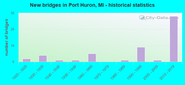
- New bridges - historical statistics
- 21920-1929
- 41930-1939
- 11940-1949
- 11950-1959
- 51960-1969
- 11980-1989
- 91990-1999
- 12000-2009
- 282010-2019
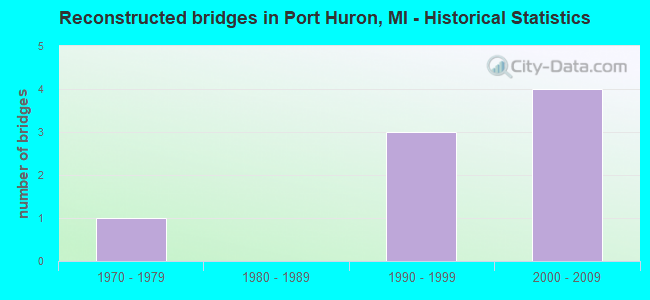
- Reconstructed bridges - Historical Statistics
- 11970-1979
- 01980-1989
- 31990-1999
- 42000-2009
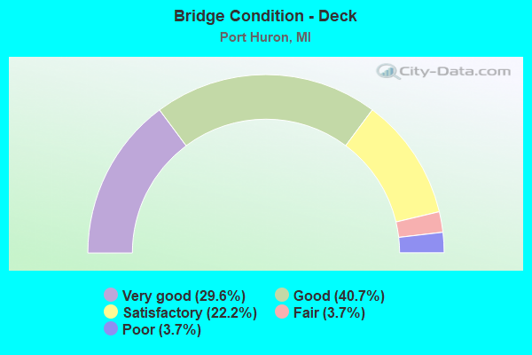
- Bridge Condition - Deck
- 29.6%Very good
- 40.7%Good
- 22.2%Satisfactory
- 3.7%Fair
- 3.7%Poor
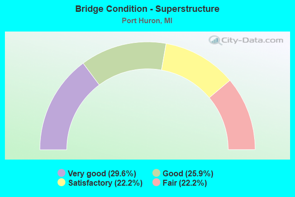
- Bridge Condition - Superstructure
- 29.6%Very good
- 25.9%Good
- 22.2%Satisfactory
- 22.2%Fair
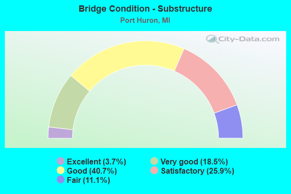
- Bridge Condition - Substructure
- 3.7%Excellent
- 18.5%Very good
- 40.7%Good
- 25.9%Satisfactory
- 11.1%Fair
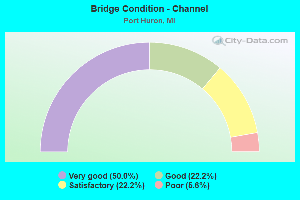
- Bridge Condition - Channel
- 50.0%Very good
- 22.2%Good
- 22.2%Satisfactory
- 5.6%Poor
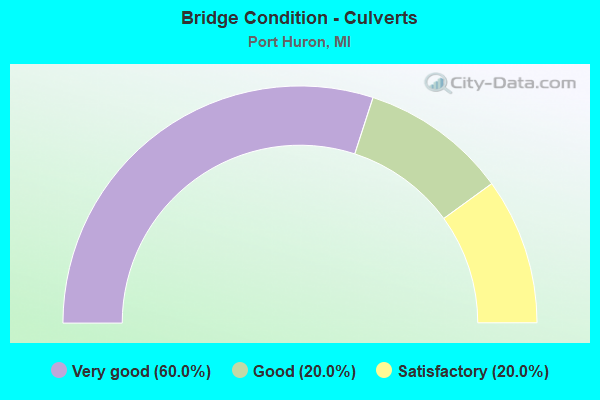
- Bridge Condition - Culverts
- 60.0%Very good
- 20.0%Good
- 20.0%Satisfactory
Find on map >> Show street view
Structure Number: 993, Location: 0.7 MI E OF I-94 (Lat: 42.971358, Lng: -82.469092), Route carried "on" structure: Interstate 69, Year Built: 1965, Year Reconstructed: 2007, Status: Open, Structure Length: 4.65m (15.26ft), Average Daily Traffic: 4,887 (year 2007), Truck Traffic: 4%, Average Future Daily Traffic: 6,274 (year 2018), Design Load: HS 20, Features Intersected: GTW RR
Minimum Vertical Clearance: 30.48m (100.00ft), Kilometerpoint: 44.065, Lanes on structure: 2, Base Highway Network: Yes (Inventory Route: 96, Subroute: 6), Owner: State Highway Agency, Approaching Roadway Width: 12.5m (41.0ft), Skew: 2 degrees, Material/Design: Prestressed concrete, Design/Construction: Stringer/Multi-beam, Number Of Spans In Main Unit: 3, Length of Maximum Span: 15.5m (50.9ft), Curb-To-Curb Width: 11.7m (38.4ft), Out-to-Out Width: 12.9m (42.3ft)
Condition: Deck: Satisfactory, Superstructure: Fair, Substructure: Fair, Operating Rating: 54.1 metric tons, Method Used To Determine Operating Rating: Load Factor (LF) rating reported by rating factor (RF) method using MS18 loading, Inventory Rating: 32.4 metric tons, Method Used To Determine Inventory Rating: Load Factor (LF) rating reported by rating factor (RF) method using MS18 loading, Structural Evaluation: Somewhat better than minimum adequacy, Deck Geometry: Equal to present minimum criteria, Approach Roadway Alignment: Equal to present desirable criteria, Designated Inspection Frequency: Every 24 months, Inspection Date: October 2021, Deck Structure Type: Concrete Cast-file-Place, Wearing Surface/Protective System: Wearing Surface: Integral Concrete
Find on map >> Show street view
Structure Number: 9932, Location: 0.7 MI E OF I-94 (Lat: 42.971506, Lng: -82.468736), Route carried "on" structure: Interstate 69, Year Built: 1965, Year Reconstructed: 2007, Status: Open, Structure Length: 4.65m (15.26ft), Average Daily Traffic: 4,887 (year 2007), Truck Traffic: 4%, Average Future Daily Traffic: 6,274 (year 2018), Design Load: HS 20, Features Intersected: GTW RR
Minimum Vertical Clearance: 30.48m (100.00ft), Kilometerpoint: 44.168, Lanes on structure: 2, Base Highway Network: Yes (Inventory Route: 96, Subroute: 2), Owner: State Highway Agency, Approaching Roadway Width: 12.8m (42.0ft), Skew: 2 degrees, Material/Design: Prestressed concrete, Design/Construction: Stringer/Multi-beam, Number Of Spans In Main Unit: 3, Length of Maximum Span: 15.5m (50.9ft), Curb-To-Curb Width: 11.7m (38.4ft), Out-to-Out Width: 12.9m (42.3ft)
Condition: Deck: Satisfactory, Superstructure: Fair, Substructure: Satisfactory, Operating Rating: 69.7 metric tons, Method Used To Determine Operating Rating: Load Factor (LF) rating reported by rating factor (RF) method using MS18 loading, Inventory Rating: 41.5 metric tons, Method Used To Determine Inventory Rating: Load Factor (LF) rating reported by rating factor (RF) method using MS18 loading, Structural Evaluation: Somewhat better than minimum adequacy, Deck Geometry: Equal to present minimum criteria, Underclear: Better than present minimum criteria, Approach Roadway Alignment: Equal to present desirable criteria, Designated Inspection Frequency: Every 24 months, Inspection Date: October 2021, Deck Structure Type: Concrete Cast-file-Place, Wearing Surface/Protective System: Wearing Surface: Integral Concrete
Find on map >> Show street view
Structure Number: 9956, Location: IN PORT HURON (MILITARY A (Lat: 42.975758, Lng: -82.424289), Route carried "on" structure: Business Interstate 94, Year Built: 1991, Status: Open, Structure Length: 4.48m (14.70ft), Average Daily Traffic: 16,311 (year 2007), Truck Traffic: 3%, Average Future Daily Traffic: 9,706 (year 2018), Design Load: HS 25 or greater, Features Intersected: BLACK RIVER
Minimum Vertical Clearance: 30.48m (100.00ft), Kilometerpoint: 33.204, Lanes on structure: 4, Base Highway Network: Yes (Inventory Route: 96, Subroute: 9), Owner: State Highway Agency, Approaching Roadway Width: 14.9m (48.9ft), Navigation Control: Yes ( Vertical Clearance: 0.3m (1.0ft), Horizontal Clearance: 23.0m (75.5ft)), Material/Design: Steel, Design/Construction: Movable - Bascule, Number Of Spans In Main Unit: 1, Number Of Approach Spans: 2, Length of Maximum Span: 30.5m (100.1ft), Curb or Sidewalk Widths: Left: 2.4m (7.9ft), Right: 2.4m (7.9ft), Curb-To-Curb Width: 14.6m (47.9ft), Out-to-Out Width: 20.4m (66.9ft)
Condition: Deck: Satisfactory, Superstructure: Fair, Substructure: Satisfactory, Channel: Good, Operating Rating: 49.6 metric tons, Method Used To Determine Operating Rating: Load Factor (LF) rating reported by rating factor (RF) method using MS18 loading, Inventory Rating: 29.8 metric tons, Method Used To Determine Inventory Rating: Load Factor (LF) rating reported by rating factor (RF) method using MS18 loading, Structural Evaluation: Somewhat better than minimum adequacy, Deck Geometry: High priority of replacement, Waterway Adequacy: High priority of corrective action, Approach Roadway Alignment: Better than present minimum criteria, Designated Inspection Frequency: Every 15 months, Critical Feature Inspection Frequency: Every 15 months, Underwater Inspection Frequency: Every 60 months, Inspection Date: June 2021, Critical Feature Inspection Date: June 2021, Underwater Inspection Date: August 2020, Deck Structure Type: Open Grating, Wearing Surface/Protective System: Wearing Surface: Other
Find on map >> Show street view
Structure Number: 9958, Location: 3.5 MI N OF M-136 (Lat: 43.068406, Lng: -82.465097), Route carried "on" structure: State highway 25, Year Built: 1948, Status: Open, Structure Length: 1.06m (3.48ft), Average Daily Traffic: 15,773 (year 2007), Truck Traffic: 3%, Average Future Daily Traffic: 19,376 (year 2018), Design Load: HS 20, Features Intersected: DOE CREEK
Minimum Vertical Clearance: 30.48m (100.00ft), Kilometerpoint: 8.419, Lanes on structure: 2, Base Highway Network: Yes (Inventory Route: 96, Subroute: 4), Owner: State Highway Agency, Approaching Roadway Width: 13.4m (44.0ft), Skew: 1 degrees, Material/Design: Steel, Design/Construction: Stringer/Multi-beam, Number Of Spans In Main Unit: 1, Length of Maximum Span: 10.6m (34.8ft), Curb-To-Curb Width: 11.5m (37.7ft), Out-to-Out Width: 13.2m (43.3ft)
Condition: Deck: Satisfactory, Superstructure: Satisfactory, Substructure: Satisfactory, Channel: Satisfactory, Operating Rating: 61.2 metric tons, Method Used To Determine Operating Rating: Load Factor (LF) rating reported by rating factor (RF) method using MS18 loading, Inventory Rating: 36.6 metric tons, Method Used To Determine Inventory Rating: Load Factor (LF) rating reported by rating factor (RF) method using MS18 loading, Structural Evaluation: Equal to present minimum criteria, Deck Geometry: Meets minimum limits, Waterway Adequacy: Equal to present desirable criteria, Approach Roadway Alignment: Better than present minimum criteria, Designated Inspection Frequency: Every 24 months, Inspection Date: March 2021, Deck Structure Type: Concrete Cast-file-Place, Wearing Surface/Protective System: Wearing Surface: Latex Concrete
Find on map >> Show street view
Structure Number: 9981, Location: IN PORT HURON (Lat: 43.016439, Lng: -82.450775), Route carried "on" structure: State highway 136, Year Built: 2000, Status: Open, Structure Length: 5.03m (16.50ft), Average Daily Traffic: 42,526 (year 2007), Truck Traffic: 2%, Average Future Daily Traffic: 38,958 (year 2018), Design Load: HS 25 or greater, Features Intersected: BLACK RIVER SPILLWAY, Facility Carried by Structure: M-25
Minimum Vertical Clearance: 30.48m (100.00ft), Kilometerpoint: 4.374, Lanes on structure: 5, Base Highway Network: Yes (Inventory Route: 96, Subroute: 3), Owner: State Highway Agency, Approaching Roadway Width: 19.5m (64.0ft), Skew: 1 degrees, Material/Design: Prestressed concrete, Design/Construction: Stringer/Multi-beam, Number Of Spans In Main Unit: 3, Length of Maximum Span: 23.1m (75.8ft), Curb or Sidewalk Widths: Left: 1.5m (4.9ft), Right: 4.4m (14.4ft), Curb-To-Curb Width: 19.5m (64.0ft), Out-to-Out Width: 26.1m (85.6ft)
Condition: Deck: Good, Superstructure: Satisfactory, Substructure: Satisfactory, Channel: Good, Operating Rating: 72.3 metric tons, Method Used To Determine Operating Rating: Load Factor (LF) rating reported by rating factor (RF) method using MS18 loading, Inventory Rating: 37.9 metric tons, Method Used To Determine Inventory Rating: Load Factor (LF) rating reported by rating factor (RF) method using MS18 loading, Structural Evaluation: Equal to present minimum criteria, Deck Geometry: Meets minimum limits, Waterway Adequacy: Equal to present desirable criteria, Approach Roadway Alignment: Equal to present desirable criteria, Designated Inspection Frequency: Every 24 months, Inspection Date: November 2021, Deck Structure Type: Concrete Cast-file-Place, Wearing Surface/Protective System: Wearing Surface: Monolithic Concrete, Deck Protection: Epoxy Coated Reinforcing
Find on map >> Show street view
Structure Number: 9987, Location: AT PORT HURON (Lat: 42.998958, Lng: -82.425111), Route carried "on" structure: Interstate 94, Year Built: 1997, Status: Open, Structure Length: 186.25m (611.06ft), Average Daily Traffic: 6,542 (year 2016), Truck Traffic: 36%, Average Future Daily Traffic: 7,523 (year 2036), Features Intersected: ST CLAIR RIVER, CN RR
Minimum Vertical Clearance: 6.40m (21.00ft), Kilometerpoint: 41.218, Lanes on structure: 3, Lanes under structure: 16, Base Highway Network: Yes (Inventory Route: 96, Subroute: 6), Toll: Toll bridge, Owner: State Highway Agency, Approaching Roadway Width: 14.6m (47.9ft), Navigation Control: Yes ( Vertical Clearance: 41.1m (134.8ft), Horizontal Clearance: 182.8m (599.7ft)), Material/Design: Steel continuous, Design/Construction: Arch - Thru, Number Of Spans In Main Unit: 3, Number Of Approach Spans: 36, Length of Maximum Span: 281.0m (921.9ft), Curb or Sidewalk Widths: Left: 0.0m, Right: 1.2m (3.9ft), Curb-To-Curb Width: 13.2m (43.3ft), Out-to-Out Width: 15.7m (51.5ft)
Condition: Deck: Good, Superstructure: Satisfactory, Substructure: Good, Channel: Very good, Operating Rating: 71.8 metric tons, Method Used To Determine Operating Rating: Load Factor (LF), Inventory Rating: 42.7 metric tons, Method Used To Determine Inventory Rating: Load Factor (LF), Structural Evaluation: Equal to present minimum criteria, Deck Geometry: Meets minimum limits, Underclear: Equal to present minimum criteria, Waterway Adequacy: Superior to present desirable criteria, Approach Roadway Alignment: Better than present minimum criteria, Designated Inspection Frequency: Every 12 months, Critical Feature Inspection Frequency: Every 24 months, Inspection Date: October 2021, Critical Feature Inspection Date: October 2021, Deck Structure Type: Concrete Cast-file-Place, Wearing Surface/Protective System: Wearing Surface: Bituminous, Membrane: Built-up, Deck Protection: Epoxy Coated Reinforcing
Find on map >> Show street view
Structure Number: 9988, Location: AT PORT HURON (Lat: 42.999292, Lng: -82.424869), Route carried "on" structure: Interstate 94, Year Built: 1938, Year Reconstructed: 1999, Status: Open, Structure Length: 188.32m (617.85ft), Average Daily Traffic: 7,234 (year 2007), Truck Traffic: 28%, Average Future Daily Traffic: 9,068 (year 2018), Features Intersected: ST CLAIR RIVER, CN RR
Minimum Vertical Clearance: 5.23m (17.16ft), Kilometerpoint: 41.308, Lanes on structure: 3, Lanes under structure: 17, Base Highway Network: Yes (Inventory Route: 96, Subroute: 4), Toll: Toll bridge, Owner: State Highway Agency, Approaching Roadway Width: 11.2m (36.7ft), Navigation Control: Yes ( Vertical Clearance: 41.1m (134.8ft), Horizontal Clearance: 182.8m (599.7ft)), Material/Design: Steel, Design/Construction: Truss - Thru, Number Of Spans In Main Unit: 3, Number Of Approach Spans: 64, Length of Maximum Span: 265.5m (871.1ft), Curb-To-Curb Width: 10.7m (35.1ft), Out-to-Out Width: 11.4m (37.4ft)
Condition: Deck: Good, Superstructure: Very good, Substructure: Very good, Channel: Very good, Operating Rating: 54.5 metric tons, Method Used To Determine Operating Rating: Load Factor (LF), Inventory Rating: 32.7 metric tons, Method Used To Determine Inventory Rating: Load Factor (LF), Structural Evaluation: Equal to present desirable criteria, Deck Geometry: High priority of replacement, Underclear: High priority of corrective action, Waterway Adequacy: Superior to present desirable criteria, Approach Roadway Alignment: Better than present minimum criteria, Designated Inspection Frequency: Every 12 months, Critical Feature Inspection Frequency: Every 24 months, Inspection Date: October 2021, Critical Feature Inspection Date: October 2021, Deck Structure Type: Concrete Cast-file-Place, Wearing Surface/Protective System: Wearing Surface: Latex Concrete, Deck Protection: Epoxy Coated Reinforcing
Find on map >> Show street view
Structure Number: 9992, Location: 430 FT N OF LAPEER RD (Lat: 42.980839, Lng: -82.475228), Route carried "on" structure: Interstate 94, Year Built: 1964, Status: Open, Structure Length: 0.85m (2.79ft), Average Daily Traffic: 29,650 (year 2007), Truck Traffic: 15%, Average Future Daily Traffic: 38,070 (year 2018), Design Load: HS 20, Features Intersected: STOCKS CREEK
Minimum Vertical Clearance: 30.48m (100.00ft), Kilometerpoint: 36.414, Lanes on structure: 4, Base Highway Network: Yes (Inventory Route: 96, Subroute: 6), Owner: State Highway Agency, Approaching Roadway Width: 11.0m (36.1ft), Material/Design: Steel, Design/Construction: Culvert, Number Of Spans In Main Unit: 3, Length of Maximum Span: 2.1m (6.9ft), Curb-To-Curb Width: 11.0m (36.1ft), Out-to-Out Width: 80.4m (263.8ft)
Condition: Channel: Poor, Culverts: Satisfactory, Operating Rating: 97.2 metric tons, Method Used To Determine Operating Rating: Load Factor (LF) rating reported by rating factor (RF) method using MS18 loading, Inventory Rating: 97.2 metric tons, Method Used To Determine Inventory Rating: Load Factor (LF) rating reported by rating factor (RF) method using MS18 loading, Structural Evaluation: Equal to present minimum criteria, Deck Geometry: High priority of replacement, Waterway Adequacy: Equal to present minimum criteria, Approach Roadway Alignment: Equal to present minimum criteria, Designated Inspection Frequency: Every 24 months, Inspection Date: October 2020
Find on map >> Show street view
Structure Number: 9993, Location: 1.1 MI N OF LAPEER RD (Lat: 42.990042, Lng: -82.462875), Route carried "on" structure: Interstate 94, Year Built: 2011, Status: Open, Structure Length: 0.79m (2.59ft), Average Daily Traffic: 50,660 (year 2010), Truck Traffic: 21%, Average Future Daily Traffic: 59,600 (year 2030), Design Load: HL 93, Features Intersected: STOCKS CREEK DRAIN
Minimum Vertical Clearance: 30.48m (100.00ft), Kilometerpoint: 38.037, Lanes on structure: 4, Base Highway Network: Yes (Inventory Route: 96, Subroute: 6), Owner: State Highway Agency, Approaching Roadway Width: 45.8m (150.3ft), Material/Design: Concrete, Design/Construction: Culvert, Number Of Spans In Main Unit: 1, Length of Maximum Span: 7.3m (24.0ft), Curb-To-Curb Width: 45.8m (150.3ft), Out-to-Out Width: 65.8m (215.9ft)
Condition: Channel: Very good, Culverts: Good, Operating Rating: 68.7 metric tons, Method Used To Determine Operating Rating: Load and Resistance Factor Rating (LRFR) rating reported by rating factor(RF) method using HL-93 loadings, Inventory Rating: 53.5 metric tons, Method Used To Determine Inventory Rating: Load and Resistance Factor Rating (LRFR) rating reported by rating factor(RF) method using HL-93 loadings, Structural Evaluation: Better than present minimum criteria, Deck Geometry: Superior to present desirable criteria, Waterway Adequacy: Equal to present minimum criteria, Approach Roadway Alignment: Equal to present minimum criteria, Designated Inspection Frequency: Every 24 months, Inspection Date: October 2020, Wearing Surface/Protective System: Wearing Surface: Monolithic Concrete
Find on map >> Show street view
Structure Number: 10012, Location: @ I-69 (Lat: 42.972603, Lng: -82.488306), Route carried "on" structure: Interstate 69, Year Built: 2014, Status: Open, Structure Length: 18.59m (60.99ft), Average Daily Traffic: 8,897 (year 2012), Truck Traffic: 12%, Average Future Daily Traffic: 10,567 (year 2032), Design Load: Greater than HL93, Features Intersected: I-94
Minimum Vertical Clearance: 4.60m (15.09ft), Kilometerpoint: 42.417, Lanes on structure: 2, Lanes under structure: 5, Base Highway Network: Yes (Inventory Route: 96, Subroute: 6), Owner: State Highway Agency, Approaching Roadway Width: 13.4m (44.0ft), Skew: 4 degrees, Material/Design: Steel continuous, Design/Construction: Stringer/Multi-beam, Number Of Spans In Main Unit: 3, Length of Maximum Span: 72.5m (237.9ft), Curb-To-Curb Width: 13.4m (44.0ft), Out-to-Out Width: 14.4m (47.2ft)
Condition: Deck: Very good, Superstructure: Very good, Substructure: Very good, Operating Rating: 77.8 metric tons, Method Used To Determine Operating Rating: Load and Resistance Factor Rating (LRFR) rating reported by rating factor(RF) method using HL-93 loadings, Inventory Rating: 44.4 metric tons, Method Used To Determine Inventory Rating: Load and Resistance Factor Rating (LRFR) rating reported by rating factor(RF) method using HL-93 loadings, Structural Evaluation: Equal to present desirable criteria, Deck Geometry: Superior to present desirable criteria, Underclear: Somewhat better than minimum adequacy, Approach Roadway Alignment: Somewhat better than minimum adequacy, Designated Inspection Frequency: Every 24 months, Inspection Date: August 2021, Deck Structure Type: Concrete Cast-file-Place, Wearing Surface/Protective System: Wearing Surface: Epoxy Overlay, Deck Protection: Epoxy Coated Reinforcing
Find on map >> Show street view
Structure Number: 10015, Location: 0.2 MI NE OF I-69 (Lat: 42.979711, Lng: -82.475411), Route carried "on" structure: Interstate 94, Year Built: 2013, Status: Open, Structure Length: 5.00m (16.40ft), Average Daily Traffic: 13,295 (year 2012), Truck Traffic: 12%, Average Future Daily Traffic: 15,778 (year 2032), Design Load: Greater than HL93, Features Intersected: LAPEER RD
Minimum Vertical Clearance: 30.48m (100.00ft), Kilometerpoint: 36.289, Lanes on structure: 2, Lanes under structure: 2, Base Highway Network: Yes (Inventory Route: 96, Subroute: 6), Owner: State Highway Agency, Approaching Roadway Width: 12.5m (41.0ft), Material/Design: Prestressed concrete, Design/Construction: Box Beam or Girders - Multiple, Number Of Spans In Main Unit: 3, Length of Maximum Span: 28.7m (94.2ft), Curb-To-Curb Width: 16.6m (54.5ft), Out-to-Out Width: 17.7m (58.1ft)
Condition: Deck: Very good, Superstructure: Very good, Substructure: Very good, Operating Rating: 70.3 metric tons, Method Used To Determine Operating Rating: Load and Resistance Factor Rating (LRFR) rating reported by rating factor(RF) method using HL-93 loadings, Inventory Rating: 51.2 metric tons, Method Used To Determine Inventory Rating: Load and Resistance Factor Rating (LRFR) rating reported by rating factor(RF) method using HL-93 loadings, Structural Evaluation: Equal to present desirable criteria, Deck Geometry: Superior to present desirable criteria, Underclear: Equal to present minimum criteria, Approach Roadway Alignment: Better than present minimum criteria, Designated Inspection Frequency: Every 24 months, Inspection Date: September 2021, Deck Structure Type: Concrete Cast-file-Place, Wearing Surface/Protective System: Wearing Surface: Epoxy Overlay, Deck Protection: Epoxy Coated Reinforcing
Find on map >> Show street view
Structure Number: 10017, Location: 0.7 MI W OF PORT HURON (Lat: 42.990550, Lng: -82.458356), Route carried "on" structure: Ramp Interstate 94, Year Built: 2011, Status: Open, Structure Length: 7.01m (23.00ft), Average Daily Traffic: 5,600 (year 2010), Truck Traffic: 6%, Average Future Daily Traffic: 6,600 (year 2030), Design Load: HL 93, Features Intersected: I-94
Minimum Vertical Clearance: 30.48m (100.00ft), Kilometerpoint: 1.405, Lanes on structure: 1, Lanes under structure: 7, Owner: State Highway Agency, Approaching Roadway Width: 17.2m (56.4ft), Skew: 9 degrees, Material/Design: Prestressed concrete, Design/Construction: Stringer/Multi-beam, Number Of Spans In Main Unit: 3, Length of Maximum Span: 24.2m (79.4ft), Curb-To-Curb Width: 17.2m (56.4ft), Out-to-Out Width: 19.4m (63.6ft)
Condition: Deck: Very good, Superstructure: Very good, Substructure: Good, Operating Rating: 73.5 metric tons, Method Used To Determine Operating Rating: Load and Resistance Factor Rating (LRFR) rating reported by rating factor(RF) method using HL-93 loadings, Inventory Rating: 42.1 metric tons, Method Used To Determine Inventory Rating: Load and Resistance Factor Rating (LRFR) rating reported by rating factor(RF) method using HL-93 loadings, Structural Evaluation: Better than present minimum criteria, Deck Geometry: Superior to present desirable criteria, Underclear: Somewhat better than minimum adequacy, Approach Roadway Alignment: Equal to present minimum criteria, Designated Inspection Frequency: Every 24 months, Inspection Date: September 2021, Deck Structure Type: Concrete Cast-file-Place, Wearing Surface/Protective System: Wearing Surface: Epoxy Overlay, Deck Protection: Epoxy Coated Reinforcing
Find on map >> Show street view
Structure Number: 10018, Location: 0.3 MI W OF PORT HURON (Lat: 42.991492, Lng: -82.451361), Route carried "on" structure: County highway 2012, Year Built: 2011, Status: Open, Structure Length: 7.79m (25.56ft), Average Daily Traffic: 11,560 (year 2010), Truck Traffic: 10%, Average Future Daily Traffic: 13,600 (year 2030), Design Load: HL 93, Features Intersected: I-94 US LANES, Facility Carried by Structure: WATER ST
Minimum Vertical Clearance: 30.48m (100.00ft), Kilometerpoint: 2.046, Lanes on structure: 3, Lanes under structure: 8, Owner: State Highway Agency, Approaching Roadway Width: 17.7m (58.1ft), Skew: 9 degrees, Material/Design: Prestressed concrete, Design/Construction: Stringer/Multi-beam, Number Of Spans In Main Unit: 3, Length of Maximum Span: 29.8m (97.8ft), Curb or Sidewalk Widths: Left: 0.0m, Right: 3.0m (9.8ft), Curb-To-Curb Width: 17.7m (58.1ft), Out-to-Out Width: 18.6m (61.0ft)
Condition: Deck: Good, Superstructure: Very good, Substructure: Good, Operating Rating: 64.8 metric tons, Method Used To Determine Operating Rating: Load and Resistance Factor Rating (LRFR) rating reported by rating factor(RF) method using HL-93 loadings, Inventory Rating: 50.2 metric tons, Method Used To Determine Inventory Rating: Load and Resistance Factor Rating (LRFR) rating reported by rating factor(RF) method using HL-93 loadings, Structural Evaluation: Better than present minimum criteria, Deck Geometry: Superior to present desirable criteria, Underclear: Somewhat better than minimum adequacy, Approach Roadway Alignment: Equal to present desirable criteria, Designated Inspection Frequency: Every 24 months, Inspection Date: December 2020, Deck Structure Type: Concrete Cast-file-Place, Wearing Surface/Protective System: Wearing Surface: Epoxy Overlay, Deck Protection: Epoxy Coated Reinforcing
Find on map >> Show street view
Structure Number: 10019, Location: IN PORT HURON OVER M-25 (Lat: 42.997967, Lng: -82.441189), Route carried "on" structure: Interstate 94, Year Built: 1964, Year Reconstructed: 1982, Status: Open, Structure Length: 8.23m (27.00ft), Average Daily Traffic: 21,619 (year 2007), Truck Traffic: 14%, Average Future Daily Traffic: 24,478 (year 2015), Design Load: HS 20+Mod, Features Intersected: M-25 CONN
Minimum Vertical Clearance: 30.48m (100.00ft), Kilometerpoint: 40.122, Lanes on structure: 1, Lanes under structure: 2, Base Highway Network: Yes (Inventory Route: 96, Subroute: 4), Owner: State Highway Agency, Approaching Roadway Width: 10.6m (34.8ft), Skew: 7 degrees, Material/Design: Steel, Design/Construction: Stringer/Multi-beam, Number Of Spans In Main Unit: 3, Length of Maximum Span: 34.7m (113.8ft), Curb or Sidewalk Widths: Left: 0.1m (0.3ft), Right: 0.1m (0.3ft), Curb-To-Curb Width: 7.0m (23.0ft), Out-to-Out Width: 7.7m (25.3ft)
Condition: Deck: Fair, Superstructure: Fair, Substructure: Fair, Operating Rating: 68.7 metric tons, Method Used To Determine Operating Rating: Load Factor (LF) rating reported by rating factor (RF) method using MS18 loading, Inventory Rating: 41.1 metric tons, Method Used To Determine Inventory Rating: Load Factor (LF) rating reported by rating factor (RF) method using MS18 loading, Structural Evaluation: Somewhat better than minimum adequacy, Deck Geometry: High priority of replacement, Underclear: Somewhat better than minimum adequacy, Approach Roadway Alignment: Meets minimum limits, Designated Inspection Frequency: Every 12 months, Inspection Date: October 2021, Bridge Improvement Cost: $143,000, Deck Structure Type: Concrete Cast-file-Place, Wearing Surface/Protective System: Wearing Surface: Latex Concrete
Find on map >> Show street view
Structure Number: 1002, Location: S END OF INTERCHG (Lat: 42.971000, Lng: -82.489222), Route carried "on" structure: Ramp Interstate 94, Year Built: 2013, Status: Open, Structure Length: 17.22m (56.50ft), Average Daily Traffic: 17,794 (year 2013), Truck Traffic: 12%, Average Future Daily Traffic: 21,131 (year 2033), Design Load: Greater than HL93, Features Intersected: I-94
Minimum Vertical Clearance: 30.48m (100.00ft), Kilometerpoint: 0.286, Lanes on structure: 1, Lanes under structure: 5, Owner: State Highway Agency, Approaching Roadway Width: 9.8m (32.2ft), Skew: 9 degrees, Material/Design: Steel continuous, Design/Construction: Stringer/Multi-beam, Number Of Spans In Main Unit: 3, Length of Maximum Span: 68.6m (225.1ft), Curb-To-Curb Width: 11.0m (36.1ft), Out-to-Out Width: 11.9m (39.0ft)
Condition: Deck: Very good, Superstructure: Good, Substructure: Good, Operating Rating: 45.4 metric tons, Method Used To Determine Operating Rating: Load and Resistance Factor Rating (LRFR) rating reported by rating factor(RF) method using HL-93 loadings, Inventory Rating: 35.0 metric tons, Method Used To Determine Inventory Rating: Load and Resistance Factor Rating (LRFR) rating reported by rating factor(RF) method using HL-93 loadings, Structural Evaluation: Better than present minimum criteria, Deck Geometry: Superior to present desirable criteria, Underclear: High priority of corrective action, Approach Roadway Alignment: Meets minimum limits, Designated Inspection Frequency: Every 24 months, Inspection Date: September 2021, Deck Structure Type: Concrete Cast-file-Place, Wearing Surface/Protective System: Wearing Surface: Epoxy Overlay, Deck Protection: Epoxy Coated Reinforcing
Find on map >> Show street view
Structure Number: 10023, Location: 1.9 MI NW OF PORT HURON (Lat: 43.027828, Lng: -82.456058), Route carried "on" structure: State highway 25, Year Built: 1981, Status: Open, Structure Length: 0.78m (2.56ft), Average Daily Traffic: 28,550 (year 2018), Truck Traffic: 3%, Average Future Daily Traffic: 31,550 (year 2038), Design Load: HS 25 or greater, Features Intersected: HOWE DRAIN
Minimum Vertical Clearance: 30.48m (100.00ft), Kilometerpoint: 0.695, Lanes on structure: 5, Owner: State Highway Agency, Approaching Roadway Width: 18.9m (62.0ft), Skew: 2 degrees, Material/Design: Prestressed concrete, Design/Construction: Box Beam or Girders - Multiple, Number Of Spans In Main Unit: 1, Length of Maximum Span: 7.6m (24.9ft), Curb or Sidewalk Widths: Left: 3.5m (11.5ft), Right: 3.5m (11.5ft), Curb-To-Curb Width: 19.7m (64.6ft), Out-to-Out Width: 27.7m (90.9ft)
Condition: Deck: Very good, Superstructure: Fair, Substructure: Fair, Channel: Satisfactory, Operating Rating: 77.1 metric tons, Method Used To Determine Operating Rating: Load Factor (LF) rating reported by rating factor (RF) method using MS18 loading, Inventory Rating: 46.3 metric tons, Method Used To Determine Inventory Rating: Load Factor (LF) rating reported by rating factor (RF) method using MS18 loading, Structural Evaluation: Somewhat better than minimum adequacy, Deck Geometry: Meets minimum limits, Waterway Adequacy: Equal to present desirable criteria, Approach Roadway Alignment: Equal to present desirable criteria, Designated Inspection Frequency: Every 24 months, Inspection Date: August 2021, Deck Structure Type: Concrete Precast Panels, Wearing Surface/Protective System: Wearing Surface: Bituminous, Membrane: Preformed Fabric
Find on map >> Show street view
Structure Number: 10069, Location: SEC. 17-20 FT GRATIOT TWP (Lat: 43.038764, Lng: -82.486000), Route carried "on" structure: County highway , Year Built: 1935, Year Reconstructed: 1990, Status: Open, Structure Length: 1.04m (3.41ft), Average Daily Traffic: 7,348 (year 2007), Truck Traffic: 5%, Average Future Daily Traffic: 10,485 (year 2023), Design Load: HS 20+Mod, Features Intersected: HOWE DRAIN, Facility Carried by Structure: KEEWAHDIN ROAD
Minimum Vertical Clearance: 30.48m (100.00ft), Kilometerpoint: 3.428, Lanes on structure: 2, Owner: County Highway Agency, Approaching Roadway Width: 10.4m (34.1ft), Skew: 3 degrees, Material/Design: Concrete, Design/Construction: Box Beam or Girders - Multiple, Number Of Spans In Main Unit: 1, Length of Maximum Span: 7.0m (23.0ft), Curb-To-Curb Width: 14.0m (45.9ft), Out-to-Out Width: 14.7m (48.2ft)
Condition: Deck: Good, Superstructure: Satisfactory, Substructure: Satisfactory, Channel: Good, Operating Rating: 59.6 metric tons, Method Used To Determine Operating Rating: Load Factor (LF) rating reported by rating factor (RF) method using MS18 loading, Inventory Rating: 35.6 metric tons, Method Used To Determine Inventory Rating: Load Factor (LF) rating reported by rating factor (RF) method using MS18 loading, Structural Evaluation: Equal to present minimum criteria, Deck Geometry: Superior to present desirable criteria, Waterway Adequacy: Equal to present desirable criteria, Approach Roadway Alignment: Equal to present desirable criteria, Designated Inspection Frequency: Every 24 months, Inspection Date: November 2021, Deck Structure Type: Concrete Precast Panels, Wearing Surface/Protective System: Wearing Surface: Bituminous
Find on map >> Show street view
Structure Number: 10112, Location: SEC 15 FT GRATIOT TWP (Lat: 43.041533, Lng: -82.446561), Route carried "on" structure: County highway 2012, Year Built: 2012, Status: Open, Structure Length: 0.80m (2.62ft), Average Daily Traffic: 4,800 (year 2012), Truck Traffic: 8%, Average Future Daily Traffic: 7,100 (year 2032), Design Load: H 20, Features Intersected: CARRIGAN DRAIN, Facility Carried by Structure: LAKESHORE DRIVE
Minimum Vertical Clearance: 30.48m (100.00ft), Kilometerpoint: 5.052, Lanes on structure: 2, Owner: County Highway Agency, Approaching Roadway Width: 11.0m (36.1ft), Material/Design: Concrete, Design/Construction: Culvert, Number Of Spans In Main Unit: 1, Length of Maximum Span: 7.5m (24.6ft), Curb or Sidewalk Widths: Left: 1.2m (3.9ft), Right: 0.0m, Curb-To-Curb Width: 12.4m (40.7ft), Out-to-Out Width: 19.6m (64.3ft)
Condition: Channel: Very good, Culverts: Very good, Operating Rating: 81.0 metric tons, Method Used To Determine Operating Rating: Load and Resistance Factor Rating (LRFR) rating reported by rating factor(RF) method using HL-93 loadings, Inventory Rating: 61.6 metric tons, Method Used To Determine Inventory Rating: Load and Resistance Factor Rating (LRFR) rating reported by rating factor(RF) method using HL-93 loadings, Structural Evaluation: Equal to present desirable criteria, Deck Geometry: Equal to present minimum criteria, Waterway Adequacy: Equal to present minimum criteria, Approach Roadway Alignment: Equal to present desirable criteria, Designated Inspection Frequency: Every 24 months, Inspection Date: December 2020, Wearing Surface/Protective System: Wearing Surface: Bituminous
Find on map >> Show street view
Structure Number: 10163, Location: SEC. 20-21 FT GRATIOT TWP (Lat: 43.037186, Lng: -82.476431), Route carried "on" structure: ServiceCounty highway , Year Built: 1995, Status: Open, Structure Length: 1.46m (4.79ft), Average Daily Traffic: 1,590 (year 2003), Truck Traffic: 5%, Average Future Daily Traffic: 2,870 (year 2023), Design Load: HS 20, Features Intersected: HOWE DRAIN, Facility Carried by Structure: PARKER ROAD
Minimum Vertical Clearance: 30.48m (100.00ft), Kilometerpoint: 2.578, Lanes on structure: 2, Owner: County Highway Agency, Approaching Roadway Width: 8.5m (27.9ft), Material/Design: Prestressed concrete, Design/Construction: Box Beam or Girders - Multiple, Number Of Spans In Main Unit: 1, Length of Maximum Span: 13.4m (44.0ft), Curb-To-Curb Width: 8.8m (28.9ft), Out-to-Out Width: 9.5m (31.2ft)
Condition: Deck: Good, Superstructure: Good, Substructure: Good, Channel: Satisfactory, Operating Rating: 53.8 metric tons, Method Used To Determine Operating Rating: Load Factor (LF) rating reported by rating factor (RF) method using MS18 loading, Inventory Rating: 32.4 metric tons, Method Used To Determine Inventory Rating: Load Factor (LF) rating reported by rating factor (RF) method using MS18 loading, Structural Evaluation: Better than present minimum criteria, Deck Geometry: Somewhat better than minimum adequacy, Waterway Adequacy: Better than present minimum criteria, Approach Roadway Alignment: Equal to present desirable criteria, Designated Inspection Frequency: Every 24 months, Inspection Date: November 2021, Deck Structure Type: Concrete Cast-file-Place, Wearing Surface/Protective System: Wearing Surface: Bituminous, Membrane: Preformed Fabric
Find on map >> Show street view
Structure Number: 10164, Location: SEC. 8-9 FT GRATIOT TWP. (Lat: 43.067892, Lng: -82.478336), Route carried "on" structure: ServiceCounty highway , Year Built: 1991, Status: Open, Structure Length: 1.10m (3.61ft), Average Daily Traffic: 185 (year 1989), Truck Traffic: 4%, Average Future Daily Traffic: 334 (year 2009), Design Load: HS 20+Mod, Features Intersected: DOE CREEK DRAIN, Facility Carried by Structure: PARKER ROAD
Minimum Vertical Clearance: 30.48m (100.00ft), Kilometerpoint: 5.993, Lanes on structure: 2, Owner: County Highway Agency, Approaching Roadway Width: 6.1m (20.0ft), Material/Design: Wood or Timber, Design/Construction: Slab, Number Of Spans In Main Unit: 1, Length of Maximum Span: 10.4m (34.1ft), Curb-To-Curb Width: 10.4m (34.1ft), Out-to-Out Width: 11.0m (36.1ft)
Condition: Deck: Satisfactory, Superstructure: Satisfactory, Substructure: Satisfactory, Channel: Satisfactory, Operating Rating: 47.6 metric tons, Method Used To Determine Operating Rating: Allowable Stress (AS) rating reported by rating factor (RF) method using MS18 loading, Inventory Rating: 33.0 metric tons, Method Used To Determine Inventory Rating: Allowable Stress (AS) rating reported by rating factor (RF) method using MS18 loading, Structural Evaluation: Equal to present minimum criteria, Deck Geometry: Better than present minimum criteria, Waterway Adequacy: Equal to present desirable criteria, Approach Roadway Alignment: Equal to present desirable criteria, Designated Inspection Frequency: Every 24 months, Inspection Date: November 2021, Deck Structure Type: Wood or Timber, Wearing Surface/Protective System: Wearing Surface: Bituminous
Find on map >> Show street view
Structure Number: 10256, Location: IN PORT HURON (Lat: 42.976544, Lng: -82.427375), Route carried "on" structure: City street 2012, Year Built: 1933, Year Reconstructed: 2007, Status: Open, Structure Length: 8.30m (27.23ft), Average Daily Traffic: 9,076 (year 2012), Truck Traffic: 15%, Average Future Daily Traffic: 10,500 (year 2032), Design Load: HS 20, Features Intersected: BLACK RIVER, Facility Carried by Structure: 7TH STREET
Minimum Vertical Clearance: 30.48m (100.00ft), Kilometerpoint: 1.764, Lanes on structure: 3, Owner: City or Municipal Highway Agency, Approaching Roadway Width: 11.9m (39.0ft), Skew: 10 degrees, Navigation Control: Yes ( Vertical Clearance: 0.3m (1.0ft), Horizontal Clearance: 17.0m (55.8ft)), Material/Design: Steel, Design/Construction: Movable - Bascule, Number Of Spans In Main Unit: 1, Number Of Approach Spans: 4, Length of Maximum Span: 35.0m (114.8ft), Curb or Sidewalk Widths: Left: 2.3m (7.5ft), Right: 2.3m (7.5ft), Curb-To-Curb Width: 12.2m (40.0ft), Out-to-Out Width: 17.3m (56.8ft)
Condition: Deck: Good, Superstructure: Satisfactory, Substructure: Satisfactory, Channel: Good, Operating Rating: 54.4 metric tons, Method Used To Determine Operating Rating: Load Factor (LF) rating reported by rating factor (RF) method using MS18 loading, Inventory Rating: 32.7 metric tons, Method Used To Determine Inventory Rating: Load Factor (LF) rating reported by rating factor (RF) method using MS18 loading, Structural Evaluation: Equal to present minimum criteria, Deck Geometry: Meets minimum limits, Waterway Adequacy: Superior to present desirable criteria, Approach Roadway Alignment: Equal to present desirable criteria, Length Of Structure Improvement: 8.29m (27.20ft), Designated Inspection Frequency: Every 24 months, Critical Feature Inspection Frequency: Every 24 months, Underwater Inspection Frequency: Every 60 months, Inspection Date: October 2020, Critical Feature Inspection Date: October 2020, Underwater Inspection Date: July 2021, Bridge Improvement Cost: $80,000, Total Project Cost: $94,000 ( Estimate for 2015), Deck Structure Type: Open Grating
Find on map >> Show street view
Structure Number: 10257, Location: IN PORT HURON (Lat: 42.980533, Lng: -82.433525), Route carried "on" structure: City street 2012, Year Built: 1957, Year Reconstructed: 2002, Status: Open, Structure Length: 11.43m (37.50ft), Average Daily Traffic: 15,710 (year 2017), Truck Traffic: 8%, Average Future Daily Traffic: 18,852 (year 2037), Design Load: HS 20, Features Intersected: BLACK RIVER, Facility Carried by Structure: 10TH STREET
Minimum Vertical Clearance: 30.48m (100.00ft), Kilometerpoint: 3.011, Lanes on structure: 4, Owner: City or Municipal Highway Agency, Approaching Roadway Width: 13.4m (44.0ft), Navigation Control: Yes ( Vertical Clearance: 3.9m (12.8ft), Horizontal Clearance: 17.5m (57.4ft)), Material/Design: Steel, Design/Construction: Movable - Bascule, Number Of Spans In Main Unit: 1, Number Of Approach Spans: 2, Length of Maximum Span: 57.9m (190.0ft), Curb or Sidewalk Widths: Left: 1.6m (5.2ft), Right: 1.6m (5.2ft), Curb-To-Curb Width: 13.4m (44.0ft), Out-to-Out Width: 17.5m (57.4ft)
Condition: Deck: Satisfactory, Superstructure: Fair, Substructure: Good, Channel: Very good, Operating Rating: 52.5 metric tons, Method Used To Determine Operating Rating: Load Factor (LF) rating reported by rating factor (RF) method using MS18 loading, Inventory Rating: 31.4 metric tons, Method Used To Determine Inventory Rating: Load Factor (LF) rating reported by rating factor (RF) method using MS18 loading, Structural Evaluation: Somewhat better than minimum adequacy, Deck Geometry: High priority of replacement, Waterway Adequacy: Superior to present desirable criteria, Approach Roadway Alignment: Equal to present desirable criteria, Length Of Structure Improvement: 3.32m (10.89ft), Designated Inspection Frequency: Every 24 months, Critical Feature Inspection Frequency: Every 24 months, Underwater Inspection Frequency: Every 60 months, Other Special Inspection Frequency: Every 24 months, Inspection Date: October 2020, Critical Feature Inspection Date: October 2020, Underwater Inspection Date: July 2021, Other Special Inspection Date: October 2020, Bridge Improvement Cost: $1,255,000, Total Project Cost: $1,500,000, Deck Structure Type: Open Grating
Find on map >> Show street view
Structure Number: 12762, Location: PORT HURON @ PLAZA (Lat: 42.998544, Lng: -82.439556), Route carried "on" structure: Interstate 94, Year Built: 1992, Year Reconstructed: 2000, Status: Open, Structure Length: 3.04m (9.97ft), Average Daily Traffic: 21,619 (year 2007), Truck Traffic: 14%, Average Future Daily Traffic: 18,498 (year 2018), Design Load: HS 20, Features Intersected: EB I-94/I-69 ON RAMP
Minimum Vertical Clearance: 30.48m (100.00ft), Kilometerpoint: 40.274, Lanes on structure: 4, Lanes under structure: 2, Base Highway Network: Yes (Inventory Route: 96, Subroute: 4), Owner: State Highway Agency, Approaching Roadway Width: 9.7m (31.8ft), Skew: 30 degrees, Material/Design: Prestressed concrete, Design/Construction: Stringer/Multi-beam, Number Of Spans In Main Unit: 1, Length of Maximum Span: 28.9m (94.8ft), Curb or Sidewalk Widths: Left: 0.0m, Right: 1.5m (4.9ft), Curb-To-Curb Width: 20.8m (68.2ft), Out-to-Out Width: 36.5m (119.8ft)
Condition: Deck: Poor, Superstructure: Good, Substructure: Good, Operating Rating: 69.3 metric tons, Method Used To Determine Operating Rating: Load Factor (LF), Inventory Rating: 41.5 metric tons, Method Used To Determine Inventory Rating: Load Factor (LF), Structural Evaluation: Better than present minimum criteria, Deck Geometry: Equal to present minimum criteria, Underclear: High priority of corrective action, Approach Roadway Alignment: Equal to present desirable criteria, Designated Inspection Frequency: Every 12 months, Inspection Date: October 2021, Deck Structure Type: Concrete Cast-file-Place, Wearing Surface/Protective System: Wearing Surface: Monolithic Concrete, Deck Protection: Epoxy Coated Reinforcing
Find on map >> Show street view
Structure Number: 12763, Location: PORT HURON @ PLAZA (Lat: 42.998156, Lng: -82.436503), Route carried "on" structure: Interstate 94, Year Built: 1993, Status: Open, Structure Length: 3.70m (12.14ft), Average Daily Traffic: 43,238 (year 2007), Truck Traffic: 31%, Average Future Daily Traffic: 16,670 (year 2018), Design Load: HS 20, Features Intersected: M-25 PINE GROVE AVE
Minimum Vertical Clearance: 30.48m (100.00ft), Kilometerpoint: 40.435, Lanes on structure: 4, Lanes under structure: 4, Base Highway Network: Yes (Inventory Route: 96, Subroute: 6), Owner: State Highway Agency, Approaching Roadway Width: 67.0m (219.8ft), Skew: 1 degrees, Material/Design: Prestressed concrete, Design/Construction: Stringer/Multi-beam, Number Of Spans In Main Unit: 1, Length of Maximum Span: 35.3m (115.8ft), Curb-To-Curb Width: 130.8m (429.1ft), Out-to-Out Width: 132.0m (433.1ft)
Condition: Deck: Good, Superstructure: Good, Substructure: Good, Operating Rating: 81.4 metric tons, Method Used To Determine Operating Rating: Load Factor (LF), Inventory Rating: 45.3 metric tons, Method Used To Determine Inventory Rating: Load Factor (LF), Structural Evaluation: Better than present minimum criteria, Deck Geometry: Superior to present desirable criteria, Underclear: High priority of corrective action, Approach Roadway Alignment: Equal to present desirable criteria, Designated Inspection Frequency: Every 12 months, Inspection Date: October 2021, Deck Structure Type: Concrete Cast-file-Place, Wearing Surface/Protective System: Wearing Surface: Monolithic Concrete, Deck Protection: Epoxy Coated Reinforcing
Find on map >> Show street view
Structure Number: 13447, Location: IN PORT HURON(MILITARY A (Lat: 42.960850, Lng: -82.426314), Route carried "on" structure: State highway 25, Year Built: 2010, Status: Open, Structure Length: 0.93m (3.05ft), Average Daily Traffic: 14,697 (year 2006), Truck Traffic: 8%, Average Future Daily Traffic: 9,300 (year 2030), Design Load: Greater than HL93, Features Intersected: BIKE PATH
Minimum Vertical Clearance: 30+ m (98+ ft), Kilometerpoint: 31.520, Lanes on structure: 4, Base Highway Network: Yes (Inventory Route: 96, Subroute: 9), Owner: State Highway Agency, Approaching Roadway Width: 14.6m (47.9ft), Skew: 5 degrees, Material/Design: Concrete, Design/Construction: Culvert, Number Of Spans In Main Unit: 1, Length of Maximum Span: 8.2m (26.9ft), Curb or Sidewalk Widths: Left: 1.8m (5.9ft), Right: 0.0m, Curb-To-Curb Width: 14.6m (47.9ft), Out-to-Out Width: 45.9m (150.6ft)
Condition: Culverts: Very good, Operating Rating: 97.2 metric tons, Method Used To Determine Operating Rating: Load and Resistance Factor Rating (LRFR) rating reported by rating factor(RF) method using HL-93 loadings, Inventory Rating: 97.2 metric tons, Method Used To Determine Inventory Rating: Load and Resistance Factor Rating (LRFR) rating reported by rating factor(RF) method using HL-93 loadings, Structural Evaluation: Equal to present desirable criteria, Deck Geometry: High priority of replacement, Approach Roadway Alignment: Equal to present desirable criteria, Designated Inspection Frequency: Every 24 months, Inspection Date: April 2021, Wearing Surface/Protective System: Wearing Surface: Bituminous, Membrane: Preformed Fabric
Find on map >> Show street view
Structure Number: 13508, Location: PORT HURON TWP SEC 17-18 (Lat: 42.964306, Lng: -82.482444), Route carried "on" structure: County highway , Year Built: 2012, Status: Open, Structure Length: 3.25m (10.66ft), Average Daily Traffic: 3,775 (year 2011), Truck Traffic: 4%, Average Future Daily Traffic: 4,607 (year 2031), Design Load: HL 93, Features Intersected: CN RAILROAD, Facility Carried by Structure: MICHIGAN RD
Minimum Vertical Clearance: 30.48m (100.00ft), Kilometerpoint: 7.600, Lanes on structure: 2, Owner: County Highway Agency, Approaching Roadway Width: 13.4m (44.0ft), Skew: 1 degrees, Material/Design: Prestressed concrete, Design/Construction: Box Beam or Girders - Multiple, Number Of Spans In Main Unit: 1, Length of Maximum Span: 32.1m (105.3ft), Curb-To-Curb Width: 13.4m (44.0ft), Out-to-Out Width: 14.4m (47.2ft)
Condition: Deck: Very good, Superstructure: Very good, Substructure: Very good, Operating Rating: 49.9 metric tons, Method Used To Determine Operating Rating: Load and Resistance Factor Rating (LRFR) rating reported by rating factor(RF) method using HL-93 loadings, Inventory Rating: 39.5 metric tons, Method Used To Determine Inventory Rating: Load and Resistance Factor Rating (LRFR) rating reported by rating factor(RF) method using HL-93 loadings, Structural Evaluation: Equal to present desirable criteria, Deck Geometry: Better than present minimum criteria, Approach Roadway Alignment: Equal to present desirable criteria, Designated Inspection Frequency: Every 24 months, Inspection Date: October 2020, Deck Structure Type: Concrete Cast-file-Place, Wearing Surface/Protective System: Wearing Surface: Monolithic Concrete, Deck Protection: Epoxy Coated Reinforcing
Find on map >> Show street view
Structure Number: 13534, Location: I-69/I-94 INTERCHANGE (Lat: 42.972889, Lng: -82.490889), Route carried "on" structure: Ramp Interstate 94, Year Built: 2015, Status: Open, Structure Length: 17.54m (57.55ft), Average Daily Traffic: 17,749 (year 2013), Truck Traffic: 12%, Average Future Daily Traffic: 21,131 (year 2033), Design Load: Greater than HL93, Features Intersected: I-69
Minimum Vertical Clearance: 30.48m (100.00ft), Kilometerpoint: 0.256, Lanes on structure: 1, Lanes under structure: 4, Owner: State Highway Agency, Approaching Roadway Width: 11.0m (36.1ft), Skew: 9 degrees, Material/Design: Steel continuous, Design/Construction: Stringer/Multi-beam, Number Of Spans In Main Unit: 3, Length of Maximum Span: 69.2m (227.0ft), Curb-To-Curb Width: 11.0m (36.1ft), Out-to-Out Width: 11.9m (39.0ft)
Condition: Deck: Very good, Superstructure: Very good, Substructure: Very good, Operating Rating: 60.3 metric tons, Method Used To Determine Operating Rating: Load and Resistance Factor Rating (LRFR) rating reported by rating factor(RF) method using HL-93 loadings, Inventory Rating: 46.3 metric tons, Method Used To Determine Inventory Rating: Load and Resistance Factor Rating (LRFR) rating reported by rating factor(RF) method using HL-93 loadings, Structural Evaluation: Equal to present desirable criteria, Deck Geometry: Superior to present desirable criteria, Underclear: Equal to present minimum criteria, Approach Roadway Alignment: Better than present minimum criteria, Designated Inspection Frequency: Every 24 months, Inspection Date: September 2021, Deck Structure Type: Concrete Cast-file-Place, Wearing Surface/Protective System: Wearing Surface: Epoxy Overlay, Deck Protection: Epoxy Coated Reinforcing
Find on map >> Show street view
Structure Number: 13579, Location: W CITY LIMITS (Lat: 42.992825, Lng: -82.448272), Route carried "on" structure: Ramp Interstate 94, Year Built: 2011, Status: Open, Structure Length: 41.22m (135.24ft), Average Daily Traffic: 18,190 (year 2010), Truck Traffic: 10%, Average Future Daily Traffic: 21,400 (year 2030), Design Load: Greater than HL93, Features Intersected: BLACK RIVER & SCOTT AVE, Facility Carried by Structure: PINE GROVE AV CONN
Minimum Vertical Clearance: 30.48m (100.00ft), Kilometerpoint: 0.945, Lanes on structure: 3, Lanes under structure: 2, Owner: State Highway Agency, Approaching Roadway Width: 18.3m (60.0ft), Skew: 1 degrees, Navigation Control: Yes ( Vertical Clearance: 0.3m (1.0ft), Horizontal Clearance: 40.8m (133.9ft)), Material/Design: Prestressed concrete, Design/Construction: Stringer/Multi-beam, Number Of Spans In Main Unit: 10, Number Of Approach Spans: 1, Length of Maximum Span: 43.6m (143.0ft), Curb or Sidewalk Widths: Left: 0.0m, Right: 4.3m (14.1ft), Curb-To-Curb Width: 18.3m (60.0ft), Out-to-Out Width: 23.9m (78.4ft)
Condition: Deck: Good, Superstructure: Good, Substructure: Good, Channel: Very good, Operating Rating: 53.1 metric tons, Method Used To Determine Operating Rating: Load and Resistance Factor Rating (LRFR) rating reported by rating factor(RF) method using HL-93 loadings, Inventory Rating: 40.5 metric tons, Method Used To Determine Inventory Rating: Load and Resistance Factor Rating (LRFR) rating reported by rating factor(RF) method using HL-93 loadings, Structural Evaluation: Better than present minimum criteria, Deck Geometry: Superior to present desirable criteria, Underclear: Equal to present minimum criteria, Waterway Adequacy: Superior to present desirable criteria, Approach Roadway Alignment: Equal to present desirable criteria, Designated Inspection Frequency: Every 24 months, Underwater Inspection Frequency: Every 60 months, Inspection Date: September 2020, Underwater Inspection Date: October 2020, Deck Structure Type: Concrete Cast-file-Place, Wearing Surface/Protective System: Wearing Surface: Monolithic Concrete, Deck Protection: Epoxy Coated Reinforcing
Find on map >> Show street view
Structure Number: 1358, Location: W CITY LIMITS (Lat: 42.992969, Lng: -82.448519), Route carried "on" structure: Interstate 94, Year Built: 2011, Status: Open, Structure Length: 41.22m (135.24ft), Average Daily Traffic: 7,820 (year 2010), Truck Traffic: 10%, Average Future Daily Traffic: 9,200 (year 2030), Design Load: Greater than HL93, Features Intersected: BLACK RIVER & SCOTT AVE
Minimum Vertical Clearance: 30.48m (100.00ft), Kilometerpoint: 39.638, Lanes on structure: 3, Lanes under structure: 2, Base Highway Network: Yes (Inventory Route: 96, Subroute: 6), Owner: State Highway Agency, Approaching Roadway Width: 18.3m (60.0ft), Skew: 1 degrees, Navigation Control: Yes ( Vertical Clearance: 0.3m (1.0ft), Horizontal Clearance: 40.8m (133.9ft)), Material/Design: Prestressed concrete, Design/Construction: Stringer/Multi-beam, Number Of Spans In Main Unit: 10, Number Of Approach Spans: 1, Length of Maximum Span: 43.6m (143.0ft), Curb-To-Curb Width: 18.3m (60.0ft), Out-to-Out Width: 19.3m (63.3ft)
Condition: Deck: Good, Superstructure: Good, Substructure: Good, Channel: Very good, Operating Rating: 76.8 metric tons, Method Used To Determine Operating Rating: Load and Resistance Factor Rating (LRFR) rating reported by rating factor(RF) method using HL-93 loadings, Inventory Rating: 56.7 metric tons, Method Used To Determine Inventory Rating: Load and Resistance Factor Rating (LRFR) rating reported by rating factor(RF) method using HL-93 loadings, Structural Evaluation: Better than present minimum criteria, Deck Geometry: Better than present minimum criteria, Underclear: Superior to present desirable criteria, Waterway Adequacy: Equal to present desirable criteria, Approach Roadway Alignment: Superior to present desirable criteria, Designated Inspection Frequency: Every 24 months, Underwater Inspection Frequency: Every 60 months, Inspection Date: September 2020, Underwater Inspection Date: October 2020, Deck Structure Type: Concrete Cast-file-Place, Wearing Surface/Protective System: Wearing Surface: Monolithic Concrete, Deck Protection: Epoxy Coated Reinforcing
Find on map >> Show street view
Structure Number: 13581, Location: W CITY LIMITS (Lat: 42.995156, Lng: -82.444481), Route carried "on" structure: Interstate 94, Year Built: 2011, Status: Open, Structure Length: 41.23m (135.27ft), Average Daily Traffic: 26,010 (year 2010), Truck Traffic: 16%, Average Future Daily Traffic: 30,600 (year 2030), Design Load: Greater than HL93, Features Intersected: BLACK RIVER & SCOTT AVE
Minimum Vertical Clearance: 30.48m (100.00ft), Kilometerpoint: 39.657, Lanes on structure: 3, Lanes under structure: 2, Base Highway Network: Yes (Inventory Route: 96, Subroute: 4), Owner: State Highway Agency, Approaching Roadway Width: 18.3m (60.0ft), Skew: 1 degrees, Navigation Control: Yes ( Vertical Clearance: 0.3m (1.0ft), Horizontal Clearance: 40.8m (133.9ft)), Material/Design: Prestressed concrete, Design/Construction: Stringer/Multi-beam, Number Of Spans In Main Unit: 10, Number Of Approach Spans: 1, Length of Maximum Span: 43.6m (143.0ft), Curb-To-Curb Width: 18.3m (60.0ft), Out-to-Out Width: 19.2m (63.0ft)
Condition: Deck: Good, Superstructure: Good, Substructure: Good, Channel: Very good, Operating Rating: 59.6 metric tons, Method Used To Determine Operating Rating: Load and Resistance Factor Rating (LRFR) rating reported by rating factor(RF) method using HL-93 loadings, Inventory Rating: 45.4 metric tons, Method Used To Determine Inventory Rating: Load and Resistance Factor Rating (LRFR) rating reported by rating factor(RF) method using HL-93 loadings, Structural Evaluation: Better than present minimum criteria, Deck Geometry: Better than present minimum criteria, Underclear: Better than present minimum criteria, Waterway Adequacy: Superior to present desirable criteria, Approach Roadway Alignment: Superior to present desirable criteria, Designated Inspection Frequency: Every 24 months, Underwater Inspection Frequency: Every 60 months, Inspection Date: September 2020, Underwater Inspection Date: October 2020, Deck Structure Type: Concrete Cast-file-Place, Wearing Surface/Protective System: Wearing Surface: Monolithic Concrete, Deck Protection: Epoxy Coated Reinforcing
Find on map >> Show street view
Structure Number: 13687, Location: I-69, I-94 INTERCHANGE (Lat: 42.974000, Lng: -82.483400), Route carried "on" structure: County highway 212, Year Built: 2015, Status: Open, Structure Length: 24.16m (79.27ft), Average Daily Traffic: 2,663 (year 2012), Truck Traffic: 3%, Average Future Daily Traffic: 3,400 (year 2032), Design Load: Greater than HL93, Features Intersected: I-69, I-94, Facility Carried by Structure: MICHIGAN ROAD
Minimum Vertical Clearance: 30.48m (100.00ft), Kilometerpoint: 33.447, Lanes on structure: 2, Lanes under structure: 12, Owner: State Highway Agency, Approaching Roadway Width: 14.6m (47.9ft), Skew: 1 degrees, Material/Design: Steel continuous, Design/Construction: Stringer/Multi-beam, Number Of Spans In Main Unit: 8, Length of Maximum Span: 36.0m (118.1ft), Curb-To-Curb Width: 13.4m (44.0ft), Out-to-Out Width: 14.5m (47.6ft)
Condition: Deck: Very good, Superstructure: Very good, Substructure: Excellent, Operating Rating: 47.6 metric tons, Method Used To Determine Operating Rating: Load and Resistance Factor Rating (LRFR) rating reported by rating factor(RF) method using HL-93 loadings, Inventory Rating: 36.6 metric tons, Method Used To Determine Inventory Rating: Load and Resistance Factor Rating (LRFR) rating reported by rating factor(RF) method using HL-93 loadings, Structural Evaluation: Equal to present desirable criteria, Deck Geometry: Better than present minimum criteria, Underclear: Equal to present minimum criteria, Approach Roadway Alignment: Better than present minimum criteria, Designated Inspection Frequency: Every 24 months, Inspection Date: October 2021, Deck Structure Type: Concrete Cast-file-Place, Wearing Surface/Protective System: Wearing Surface: Monolithic Concrete, Deck Protection: Epoxy Coated Reinforcing
Find on map >> Show street view
Structure Number: 13872, Location: 0.24 MI W OF W WATER ST (Lat: 42.993472, Lng: -82.455111), Route carried "on" structure: County highway , Year Built: 2015, Status: Open, Structure Length: 0.78m (2.56ft), Average Daily Traffic: 6,794 (year 2015), Truck Traffic: 9%, Average Future Daily Traffic: 10,096 (year 2035), Design Load: Greater than HL93, Features Intersected: STOCKS CREEK, Facility Carried by Structure: WATER STREET
Minimum Vertical Clearance: 30.48m (100.00ft), Kilometerpoint: 2.424, Lanes on structure: 2, Owner: County Highway Agency, Approaching Roadway Width: 8.3m (27.2ft), Material/Design: Concrete, Design/Construction: Culvert, Number Of Spans In Main Unit: 1, Length of Maximum Span: 7.3m (24.0ft), Curb or Sidewalk Widths: Left: 0.6m (2.0ft), Right: 0.6m (2.0ft), Curb-To-Curb Width: 8.8m (28.9ft), Out-to-Out Width: 16.2m (53.1ft)
Condition: Channel: Very good, Culverts: Very good, Operating Rating: 48.6 metric tons, Method Used To Determine Operating Rating: Load and Resistance Factor Rating (LRFR) rating reported by rating factor(RF) method using HL-93 loadings, Inventory Rating: 38.9 metric tons, Method Used To Determine Inventory Rating: Load and Resistance Factor Rating (LRFR) rating reported by rating factor(RF) method using HL-93 loadings, Structural Evaluation: Equal to present desirable criteria, Deck Geometry: High priority of replacement, Waterway Adequacy: Equal to present desirable criteria, Approach Roadway Alignment: Equal to present desirable criteria, Designated Inspection Frequency: Every 24 months, Inspection Date: January 2022, Wearing Surface/Protective System: Wearing Surface: Bituminous, Membrane: Preformed Fabric
Find on map >> Show street view
Structure Number: 9987, Location: AT PORT HURON (Lat: 42.998958, Lng: -82.425111), Route carried "under" structure: City street , Year Built: 1997, Structure Length: 0. m, Average Daily Traffic: 77,777 (year 1995), Truck Traffic: 1%, Features Intersected: ST CLAIR RIVER, CN RR, Facility Carried by Structure: I-94 EB
Minimum Vertical Clearance: 6.30m (20.67ft), Kilometerpoint: 0.040, Lanes on structure: 3, Lanes under structure: 16, Toll: Toll bridge, Material/Design: Steel continuous, Design/Construction: Arch - Thru, Length of Maximum Span: 281.0m (921.9ft)
Find on map >> Show street view
Structure Number: 9988, Location: AT PORT HURON (Lat: 42.999292, Lng: -82.424869), Route carried "under" structure: City street , Year Built: 1938, Structure Length: 0. m, Average Daily Traffic: 3,027 (year 1989), Truck Traffic: 1%, Features Intersected: ST CLAIR RIVER, CN RR, Facility Carried by Structure: I-94 WB
Minimum Vertical Clearance: 5.49m (18.01ft), Kilometerpoint: 0.077, Lanes on structure: 3, Lanes under structure: 17, Toll: Toll bridge, Material/Design: Steel, Design/Construction: Truss - Thru, Length of Maximum Span: 265.5m (871.1ft)
Find on map >> Show street view
Structure Number: 10012, Location: @ I-69 (Lat: 42.972603, Lng: -82.488306), Route carried "under" structure: Interstate 94, Year Built: 2014, Structure Length: 0. m, Average Daily Traffic: 22,601 (year 2012), Truck Traffic: 12%, Features Intersected: I-94, Facility Carried by Structure: I-69 EB
Minimum Vertical Clearance: 5.51m (18.08ft), Kilometerpoint: 34.885, Lanes on structure: 2, Lanes under structure: 5, Material/Design: Steel continuous, Design/Construction: Stringer/Multi-beam, Length of Maximum Span: 72.5m (237.9ft)
Find on map >> Show street view
Structure Number: 10014, Location: @ I-69 (Lat: 42.975694, Lng: -82.478500), Route carried "under" structure: Interstate 94, Year Built: 2013, Structure Length: 0. m, Average Daily Traffic: 32,725 (year 2012), Truck Traffic: 12%, Features Intersected: I-94, Facility Carried by Structure: I-69 WB
Minimum Vertical Clearance: 5.84m (19.16ft), Kilometerpoint: 35.769, Lanes on structure: 2, Lanes under structure: 5, Material/Design: Steel continuous, Design/Construction: Stringer/Multi-beam, Length of Maximum Span: 49.7m (163.1ft)
Find on map >> Show street view
Structure Number: 10015, Location: 0.2 MI NE OF I-69 (Lat: 42.979711, Lng: -82.475411), Route carried "under" structure: County highway 2012, Year Built: 2013, Structure Length: 0. m, Average Daily Traffic: 13,800 (year 1991), Features Intersected: LAPEER RD, Facility Carried by Structure: I-94 EB
Minimum Vertical Clearance: 4.44m (14.57ft), Kilometerpoint: 27.408, Lanes on structure: 2, Lanes under structure: 2, Material/Design: Prestressed concrete, Design/Construction: Box Beam or Girders - Multiple, Length of Maximum Span: 28.7m (94.2ft)
Find on map >> Show street view
Structure Number: 10016, Location: 0.2 MI NE OF I-69 (Lat: 42.979733, Lng: -82.475772), Route carried "under" structure: County highway 1210, Year Built: 2013, Structure Length: 0. m, Average Daily Traffic: 13,800 (year 1991), Truck Traffic: 4%, Features Intersected: LAPEER RD, Facility Carried by Structure: I-94 WB
Minimum Vertical Clearance: 4.32m (14.17ft), Kilometerpoint: 27.378, Lanes on structure: 2, Lanes under structure: 2, Material/Design: Prestressed concrete, Design/Construction: Box Beam or Girders - Multiple, Length of Maximum Span: 28.7m (94.2ft)
Find on map >> Show street view
Structure Number: 10017, Location: 0.7 MI W OF PORT HURON (Lat: 42.990550, Lng: -82.458356), Route carried "under" structure: Interstate 94, Year Built: 2011, Structure Length: 0. m, Average Daily Traffic: 29,650 (year 2007), Truck Traffic: 15%, Features Intersected: I-94
Minimum Vertical Clearance: 5.31m (17.42ft), Kilometerpoint: 38.408, Lanes on structure: 1, Lanes under structure: 7, Material/Design: Prestressed concrete, Design/Construction: Stringer/Multi-beam, Length of Maximum Span: 24.2m (79.4ft)
Find on map >> Show street view
Structure Number: 10018, Location: 0.3 MI W OF PORT HURON (Lat: 42.991492, Lng: -82.451361), Route carried "under" structure: Interstate 94, Year Built: 2011, Structure Length: 0. m, Average Daily Traffic: 43,238 (year 2007), Truck Traffic: 14%, Features Intersected: I-94 US LANES, Facility Carried by Structure: WATER ST
Minimum Vertical Clearance: 5.54m (18.18ft), Kilometerpoint: 39.007, Lanes on structure: 3, Lanes under structure: 8, Material/Design: Prestressed concrete, Design/Construction: Stringer/Multi-beam, Length of Maximum Span: 29.8m (97.8ft)
Find on map >> Show street view
Structure Number: 10019, Location: IN PORT HURON OVER M-25 (Lat: 42.997967, Lng: -82.441189), Route carried "under" structure: State highway 25, Year Built: 1964, Structure Length: 0. m, Average Daily Traffic: 29,262 (year 2007), Truck Traffic: 1%, Features Intersected: M-25 CONN, Facility Carried by Structure: I-94 WB
Minimum Vertical Clearance: 4.60m (15.09ft), Kilometerpoint: 0.232, Lanes on structure: 1, Lanes under structure: 2, Material/Design: Steel, Design/Construction: Stringer/Multi-beam, Length of Maximum Span: 34.7m (113.8ft)
Find on map >> Show street view
Structure Number: 1002, Location: S END OF INTERCHG (Lat: 42.971000, Lng: -82.489222), Route carried "under" structure: Interstate 94, Year Built: 2013, Structure Length: 0. m, Average Daily Traffic: 22,601 (year 2013), Truck Traffic: 18%, Features Intersected: I-94
Minimum Vertical Clearance: 4.70m (15.42ft), Kilometerpoint: 42.377, Lanes on structure: 1, Lanes under structure: 5, Material/Design: Steel continuous, Design/Construction: Stringer/Multi-beam, Length of Maximum Span: 68.6m (225.1ft)
Find on map >> Show street view
Structure Number: 1011, Location: SEC. 16 PORT HURON TWP. (Lat: 42.961378, Lng: -82.452167), Route carried "under" structure: County highway 1210, Year Built: 1925, Structure Length: 0. m, Average Daily Traffic: 16,020 (year 1989), Features Intersected: 24TH STREET, Facility Carried by Structure: CSX-CS-C&O RR CO.
Minimum Vertical Clearance: 4.21m (13.81ft), Kilometerpoint: 2.231, Lanes under structure: 4, Material/Design: Steel, Design/Construction: Stringer/Multi-beam, Length of Maximum Span: 8.8m (28.9ft)