Bridge Statistics for Pontiac, Michigan (MI)
Condition, Traffic, Stress, Structural Evaluation, Project Costs
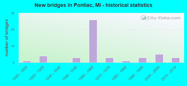
- New bridges - historical statistics
- 11920-1929
- 41930-1939
- 31950-1959
- 261960-1969
- 31970-1979
- 11980-1989
- 31990-1999
- 52000-2009
- 32010-2019

- Reconstructed bridges - Historical Statistics
- 21960-1969
- 01970-1979
- 01980-1989
- 41990-1999
- 22000-2009


- Bridge Condition - Deck
- 11.5%Very good
- 53.8%Good
- 23.1%Satisfactory
- 11.5%Fair

- Bridge Condition - Superstructure
- 11.5%Very good
- 38.5%Good
- 38.5%Satisfactory
- 11.5%Fair

- Bridge Condition - Substructure
- 11.5%Very good
- 57.7%Good
- 15.4%Satisfactory
- 11.5%Fair
- 3.8%Serious

- Bridge Condition - Channel
- 38.1%Very good
- 33.3%Good
- 23.8%Satisfactory
- 4.8%Fair

- Bridge Condition - Culverts
- 88.9%Satisfactory
- 11.1%Poor
Find on map >> Show street view
Structure Number: 783, Location: 2.5 MI NE OF NEW BUFFALO (Lat: 41.819472, Lng: -86.688158), Route carried "on" structure: Interstate 94, Year Built: 2008, Status: Open, Structure Length: 5.94m (19.49ft), Average Daily Traffic: 18,879 (year 2007), Truck Traffic: 30%, Average Future Daily Traffic: 47,000 (year 2028), Design Load: HS 25 or greater, Features Intersected: GALIEN RIVER
Minimum Vertical Clearance: 30.48m (100.00ft), Kilometerpoint: 8.509, Lanes on structure: 3, Base Highway Network: Yes (Inventory Route: 136, Subroute: 2), Owner: State Highway Agency, Approaching Roadway Width: 18.3m (60.0ft), Material/Design: Prestressed concrete, Design/Construction: Box Beam or Girders - Single/Spread, Number Of Spans In Main Unit: 3, Length of Maximum Span: 20.7m (67.9ft), Curb-To-Curb Width: 18.3m (60.0ft), Out-to-Out Width: 19.3m (63.3ft)
Condition: Deck: Good, Superstructure: Satisfactory, Substructure: Good, Channel: Fair, Operating Rating: 83.3 metric tons, Method Used To Determine Operating Rating: Load Factor (LF), Inventory Rating: 42.3 metric tons, Method Used To Determine Inventory Rating: Load Factor (LF), Structural Evaluation: Equal to present minimum criteria, Deck Geometry: Better than present minimum criteria, Waterway Adequacy: Equal to present desirable criteria, Approach Roadway Alignment: Equal to present desirable criteria, Designated Inspection Frequency: Every 24 months, Inspection Date: August 2020, Deck Structure Type: Concrete Cast-file-Place, Wearing Surface/Protective System: Wearing Surface: Monolithic Concrete, Deck Protection: Other
Find on map >> Show street view
Structure Number: 1317, Location: 0.3 MI N OF I-94 BL (Lat: 42.316250, Lng: -85.145494), Route carried "on" structure: County highway 2011, Year Built: 1968, Status: Open, Structure Length: 6.09m (19.98ft), Average Daily Traffic: 11,619 (year 1995), Truck Traffic: 8%, Average Future Daily Traffic: 12,792 (year 2013), Design Load: H 20, Features Intersected: MDOT RR CORRIDOR, Facility Carried by Structure: RAYMOND ROAD
Minimum Vertical Clearance: 30.48m (100.00ft), Kilometerpoint: 2.337, Lanes on structure: 4, Owner: County Highway Agency, Approaching Roadway Width: 15.9m (52.2ft), Skew: 1 degrees, Material/Design: Prestressed concrete, Design/Construction: Box Beam or Girders - Multiple, Number Of Spans In Main Unit: 4, Length of Maximum Span: 16.7m (54.8ft), Curb or Sidewalk Widths: Left: 1.2m (3.9ft), Right: 1.2m (3.9ft), Curb-To-Curb Width: 15.9m (52.2ft), Out-to-Out Width: 19.0m (62.3ft)
Condition: Deck: Fair, Superstructure: Satisfactory, Substructure: Serious, Operating Rating: 70.3 metric tons, Method Used To Determine Operating Rating: Load Factor (LF) rating reported by rating factor (RF) method using MS18 loading, Inventory Rating: 42.1 metric tons, Method Used To Determine Inventory Rating: Load Factor (LF) rating reported by rating factor (RF) method using MS18 loading, Structural Evaluation: High priority of corrective action, Deck Geometry: Meets minimum limits, Underclear: High priority of corrective action, Approach Roadway Alignment: Equal to present desirable criteria, Designated Inspection Frequency: Every 12 months, Inspection Date: September 2021, Deck Structure Type: Concrete Cast-file-Place, Wearing Surface/Protective System: Wearing Surface: Bituminous
Find on map >> Show street view
Structure Number: 4202, Location: 0.25 MI.WEST OF USH141 (Lat: 46.232017, Lng: -88.461003), Route carried "on" structure: Other road , Year Built: 1989, Status: Open, Structure Length: 1.52m (4.99ft), Average Daily Traffic: 110 (year 1994), Average Future Daily Traffic: 127 (year 2014), Design Load: HS 20+Mod, Features Intersected: HEMLOCK RIVER, Facility Carried by Structure: PARKS FARM RD.
Minimum Vertical Clearance: 30.48m (100.00ft), Kilometerpoint: 0.871, Lanes on structure: 2, Owner: County Highway Agency, Approaching Roadway Width: 7.3m (24.0ft), Material/Design: Prestressed concrete, Design/Construction: Box Beam or Girders - Multiple, Number Of Spans In Main Unit: 1, Length of Maximum Span: 14.3m (46.9ft), Curb-To-Curb Width: 8.2m (26.9ft), Out-to-Out Width: 8.5m (27.9ft)
Condition: Deck: Good, Superstructure: Good, Substructure: Good, Channel: Very good, Operating Rating: 66.7 metric tons, Method Used To Determine Operating Rating: Load Factor (LF) rating reported by rating factor (RF) method using MS18 loading, Inventory Rating: 39.9 metric tons, Method Used To Determine Inventory Rating: Load Factor (LF) rating reported by rating factor (RF) method using MS18 loading, Structural Evaluation: Better than present minimum criteria, Deck Geometry: Somewhat better than minimum adequacy, Waterway Adequacy: Equal to present desirable criteria, Approach Roadway Alignment: Equal to present desirable criteria, Designated Inspection Frequency: Every 24 months, Inspection Date: September 2020, Deck Structure Type: Concrete Cast-file-Place, Wearing Surface/Protective System: Wearing Surface: Bituminous, Deck Protection: Epoxy Coated Reinforcing
Find on map >> Show street view
Structure Number: 783, Location: IN PONTIAC (UNDR M-59 WB) (Lat: 42.643092, Lng: -83.280500), Route carried "on" structure: Ramp State highway 59, Year Built: 1966, Status: Open, Structure Length: 6.76m (22.18ft), Average Daily Traffic: 20,000 (year 1995), Truck Traffic: 6%, Average Future Daily Traffic: 28,587 (year 2015), Design Load: HS 20, Features Intersected: CLINTON R, Facility Carried by Structure: UNIVERSITY DR(CONN
Minimum Vertical Clearance: 4.39m (14.40ft), Kilometerpoint: 0.249, Lanes on structure: 2, Owner: State Highway Agency, Approaching Roadway Width: 9.1m (29.9ft), Skew: 6 degrees, Material/Design: Steel, Design/Construction: Stringer/Multi-beam, Number Of Spans In Main Unit: 3, Length of Maximum Span: 24.3m (79.7ft), Curb or Sidewalk Widths: Left: 0.2m (0.7ft), Right: 0.6m (2.0ft), Curb-To-Curb Width: 9.4m (30.8ft), Out-to-Out Width: 10.7m (35.1ft)
Condition: Deck: Good, Superstructure: Satisfactory, Substructure: Satisfactory, Channel: Good, Operating Rating: 85.5 metric tons, Method Used To Determine Operating Rating: Load Factor (LF) rating reported by rating factor (RF) method using MS18 loading, Inventory Rating: 48.9 metric tons, Method Used To Determine Inventory Rating: Load Factor (LF) rating reported by rating factor (RF) method using MS18 loading, Structural Evaluation: Equal to present minimum criteria, Deck Geometry: Somewhat better than minimum adequacy, Waterway Adequacy: Equal to present desirable criteria, Approach Roadway Alignment: Equal to present desirable criteria, Designated Inspection Frequency: Every 24 months, Inspection Date: May 2021, Bridge Improvement Cost: $110,000, Deck Structure Type: Concrete Cast-file-Place, Wearing Surface/Protective System: Wearing Surface: Epoxy Overlay
Find on map >> Show street view
Structure Number: 7833, Location: E LTS OF PONTIAC (Lat: 42.642408, Lng: -83.259903), Route carried "on" structure: State highway 59, Year Built: 1967, Year Reconstructed: 1998, Status: Open, Structure Length: 3.93m (12.89ft), Average Daily Traffic: 17,835 (year 2007), Truck Traffic: 6%, Average Future Daily Traffic: 20,786 (year 2018), Design Load: HS 20, Features Intersected: CLINTON RIVER
Minimum Vertical Clearance: 30.48m (100.00ft), Kilometerpoint: 1.918, Lanes on structure: 2, Base Highway Network: Yes (Inventory Route: 67, Subroute: 8), Owner: State Highway Agency, Approaching Roadway Width: 12.8m (42.0ft), Material/Design: Steel, Design/Construction: Stringer/Multi-beam, Number Of Spans In Main Unit: 3, Length of Maximum Span: 15.2m (49.9ft), Curb-To-Curb Width: 12.2m (40.0ft), Out-to-Out Width: 12.9m (42.3ft)
Condition: Deck: Good, Superstructure: Good, Substructure: Good, Channel: Satisfactory, Operating Rating: 65.8 metric tons, Method Used To Determine Operating Rating: Load Factor (LF) rating reported by rating factor (RF) method using MS18 loading, Inventory Rating: 39.5 metric tons, Method Used To Determine Inventory Rating: Load Factor (LF) rating reported by rating factor (RF) method using MS18 loading, Structural Evaluation: Better than present minimum criteria, Deck Geometry: Better than present minimum criteria, Waterway Adequacy: Equal to present desirable criteria, Approach Roadway Alignment: Equal to present desirable criteria, Designated Inspection Frequency: Every 24 months, Inspection Date: May 2021, Bridge Improvement Cost: $811,000, Deck Structure Type: Concrete Cast-file-Place, Wearing Surface/Protective System: Wearing Surface: Monolithic Concrete
Find on map >> Show street view
Structure Number: 7839, Location: E LTS OF PONTIAC (Lat: 42.641694, Lng: -83.249800), Route carried "on" structure: County highway 2059, Year Built: 1965, Year Reconstructed: 2009, Status: Open, Structure Length: 7.16m (23.49ft), Average Daily Traffic: 16,460 (year 1974), Truck Traffic: 3%, Average Future Daily Traffic: 33,223 (year 2030), Design Load: HL 93, Features Intersected: M-59, Facility Carried by Structure: OPDYKE RD
Minimum Vertical Clearance: 30.48m (100.00ft), Kilometerpoint: 6.119, Lanes on structure: 5, Lanes under structure: 8, Owner: State Highway Agency, Approaching Roadway Width: 19.2m (63.0ft), Skew: 20 degrees, Material/Design: Steel, Design/Construction: Stringer/Multi-beam, Number Of Spans In Main Unit: 4, Length of Maximum Span: 25.6m (84.0ft), Curb or Sidewalk Widths: Left: 0.0m, Right: 3.7m (12.1ft), Curb-To-Curb Width: 19.2m (63.0ft), Out-to-Out Width: 23.8m (78.1ft)
Condition: Deck: Very good, Superstructure: Good, Substructure: Good, Operating Rating: 87.5 metric tons, Method Used To Determine Operating Rating: Load Factor (LF), Inventory Rating: 52.4 metric tons, Method Used To Determine Inventory Rating: Load Factor (LF), Structural Evaluation: Better than present minimum criteria, Deck Geometry: Meets minimum limits, Underclear: Meets minimum limits, Approach Roadway Alignment: Equal to present desirable criteria, Designated Inspection Frequency: Every 24 months, Inspection Date: September 2020, Bridge Improvement Cost: $421,000, Deck Structure Type: Concrete Cast-file-Place, Wearing Surface/Protective System: Wearing Surface: Monolithic Concrete, Deck Protection: Epoxy Coated Reinforcing
Find on map >> Show street view
Structure Number: 7842, Location: IN PONTIAC (Lat: 42.644275, Lng: -83.269336), Route carried "on" structure: State highway 59, Year Built: 1967, Status: Open, Structure Length: 4.42m (14.50ft), Average Daily Traffic: 17,835 (year 2007), Truck Traffic: 6%, Average Future Daily Traffic: 20,786 (year 2018), Design Load: HS 20, Features Intersected: EAST BOULEVARD
Minimum Vertical Clearance: 30.48m (100.00ft), Kilometerpoint: 35.793, Lanes on structure: 3, Lanes under structure: 4, Base Highway Network: Yes (Inventory Route: 64, Subroute: 6), Owner: State Highway Agency, Approaching Roadway Width: 12.8m (42.0ft), Material/Design: Steel, Design/Construction: Stringer/Multi-beam, Number Of Spans In Main Unit: 3, Length of Maximum Span: 25.6m (84.0ft), Curb or Sidewalk Widths: Left: 0.2m (0.7ft), Right: 0.2m (0.7ft), Curb-To-Curb Width: 13.9m (45.6ft), Out-to-Out Width: 14.6m (47.9ft)
Condition: Deck: Good, Superstructure: Satisfactory, Substructure: Good, Operating Rating: 77.4 metric tons, Method Used To Determine Operating Rating: Load Factor (LF) rating reported by rating factor (RF) method using MS18 loading, Inventory Rating: 46.3 metric tons, Method Used To Determine Inventory Rating: Load Factor (LF) rating reported by rating factor (RF) method using MS18 loading, Structural Evaluation: Equal to present minimum criteria, Deck Geometry: Meets minimum limits, Underclear: Somewhat better than minimum adequacy, Approach Roadway Alignment: Equal to present desirable criteria, Length Of Structure Improvement: 4.42m (14.50ft), Designated Inspection Frequency: Every 24 months, Inspection Date: November 2021, Bridge Improvement Cost: $927,000, Roadway Improvement Cost: $36,000, Total Project Cost: $429,000, Deck Structure Type: Concrete Cast-file-Place, Wearing Surface/Protective System: Wearing Surface: Monolithic Concrete
Find on map >> Show street view
Structure Number: 7848, Location: IN PONTIAC (Lat: 42.643222, Lng: -83.280497), Route carried "on" structure: State highway 59, Year Built: 1966, Status: Open, Structure Length: 6.28m (20.60ft), Average Daily Traffic: 17,196 (year 2007), Truck Traffic: 7%, Average Future Daily Traffic: 17,751 (year 2018), Design Load: HS 20, Features Intersected: UNIVERSITY DR CONNECTOR
Minimum Vertical Clearance: 30.48m (100.00ft), Kilometerpoint: 0.185, Lanes on structure: 2, Lanes under structure: 2, Base Highway Network: Yes (Inventory Route: 67, Subroute: 8), Owner: State Highway Agency, Approaching Roadway Width: 12.8m (42.0ft), Skew: 6 degrees, Material/Design: Steel, Design/Construction: Stringer/Multi-beam, Number Of Spans In Main Unit: 3, Length of Maximum Span: 23.1m (75.8ft), Curb or Sidewalk Widths: Left: 0.6m (2.0ft), Right: 0.2m (0.7ft), Curb-To-Curb Width: 9.3m (30.5ft), Out-to-Out Width: 10.7m (35.1ft)
Condition: Deck: Satisfactory, Superstructure: Good, Substructure: Good, Channel: Very good, Operating Rating: 81.3 metric tons, Method Used To Determine Operating Rating: Load Factor (LF) rating reported by rating factor (RF) method using MS18 loading, Inventory Rating: 48.6 metric tons, Method Used To Determine Inventory Rating: Load Factor (LF) rating reported by rating factor (RF) method using MS18 loading, Structural Evaluation: Better than present minimum criteria, Deck Geometry: Meets minimum limits, Underclear: High priority of replacement, Waterway Adequacy: Equal to present minimum criteria, Approach Roadway Alignment: Equal to present desirable criteria, Designated Inspection Frequency: Every 24 months, Inspection Date: May 2021, Bridge Improvement Cost: $984,000, Deck Structure Type: Concrete Cast-file-Place, Wearing Surface/Protective System: Wearing Surface: Epoxy Overlay
Find on map >> Show street view
Structure Number: 7849, Location: IN PONTIAC (Lat: 42.644536, Lng: -83.269386), Route carried "on" structure: State highway 59, Year Built: 1966, Status: Open, Structure Length: 4.97m (16.31ft), Average Daily Traffic: 17,835 (year 2007), Truck Traffic: 6%, Average Future Daily Traffic: 20,786 (year 2018), Design Load: HS 20, Features Intersected: EAST BOULEVARD
Minimum Vertical Clearance: 30.48m (100.00ft), Kilometerpoint: 1.110, Lanes on structure: 2, Lanes under structure: 4, Base Highway Network: Yes (Inventory Route: 67, Subroute: 8), Owner: State Highway Agency, Approaching Roadway Width: 12.8m (42.0ft), Material/Design: Steel, Design/Construction: Stringer/Multi-beam, Number Of Spans In Main Unit: 3, Length of Maximum Span: 25.6m (84.0ft), Curb or Sidewalk Widths: Left: 0.2m (0.7ft), Right: 0.2m (0.7ft), Curb-To-Curb Width: 12.2m (40.0ft), Out-to-Out Width: 12.9m (42.3ft)
Condition: Deck: Good, Superstructure: Satisfactory, Substructure: Good, Operating Rating: 71.0 metric tons, Method Used To Determine Operating Rating: Load Factor (LF) rating reported by rating factor (RF) method using MS18 loading, Inventory Rating: 42.4 metric tons, Method Used To Determine Inventory Rating: Load Factor (LF) rating reported by rating factor (RF) method using MS18 loading, Structural Evaluation: Equal to present minimum criteria, Deck Geometry: Better than present minimum criteria, Underclear: Somewhat better than minimum adequacy, Approach Roadway Alignment: Equal to present desirable criteria, Designated Inspection Frequency: Every 24 months, Inspection Date: May 2021, Bridge Improvement Cost: $201,000, Deck Structure Type: Concrete Cast-file-Place, Wearing Surface/Protective System: Wearing Surface: Monolithic Concrete
Find on map >> Show street view
Structure Number: 7861, Location: IN PONTIAC (Lat: 42.622339, Lng: -83.324525), Route carried "on" structure: US 24, Year Built: 1957, Status: Open, Structure Length: 1.34m (4.40ft), Average Daily Traffic: 16,803 (year 2007), Truck Traffic: 3%, Average Future Daily Traffic: 25,169 (year 2018), Design Load: HS 20, Features Intersected: CLINTON RIVER
Minimum Vertical Clearance: 30.48m (100.00ft), Kilometerpoint: 5.266, Lanes on structure: 3, Base Highway Network: Yes (Inventory Route: 71, Subroute: 10), Owner: State Highway Agency, Approaching Roadway Width: 20.1m (65.9ft), Skew: 11 degrees, Material/Design: Concrete continuous, Design/Construction: Slab, Number Of Spans In Main Unit: 2, Length of Maximum Span: 6.7m (22.0ft), Curb or Sidewalk Widths: Left: 0.9m (3.0ft), Right: 0.9m (3.0ft), Curb-To-Curb Width: 16.4m (53.8ft), Out-to-Out Width: 19.0m (62.3ft)
Condition: Deck: Satisfactory, Superstructure: Fair, Substructure: Good, Channel: Very good, Operating Rating: 77.4 metric tons, Method Used To Determine Operating Rating: Load Factor (LF) rating reported by rating factor (RF) method using MS18 loading, Inventory Rating: 46.3 metric tons, Method Used To Determine Inventory Rating: Load Factor (LF) rating reported by rating factor (RF) method using MS18 loading, Structural Evaluation: Somewhat better than minimum adequacy, Deck Geometry: Better than present minimum criteria, Waterway Adequacy: Equal to present desirable criteria, Approach Roadway Alignment: Equal to present desirable criteria, Designated Inspection Frequency: Every 24 months, Inspection Date: March 2021, Deck Structure Type: Concrete Cast-file-Place, Wearing Surface/Protective System: Wearing Surface: Latex Concrete
Find on map >> Show street view
Structure Number: 7862, Location: IN PONTIAC (Lat: 42.622375, Lng: -83.324925), Route carried "on" structure: US 24, Year Built: 1957, Status: Open, Structure Length: 1.52m (4.99ft), Average Daily Traffic: 16,803 (year 2007), Truck Traffic: 3%, Average Future Daily Traffic: 25,169 (year 2018), Design Load: HS 20, Features Intersected: CLINTON RIVER
Minimum Vertical Clearance: 30.48m (100.00ft), Kilometerpoint: 0.134, Lanes on structure: 4, Base Highway Network: Yes (Inventory Route: 441, Subroute: 92), Owner: State Highway Agency, Approaching Roadway Width: 20.1m (65.9ft), Skew: 13 degrees, Material/Design: Concrete continuous, Design/Construction: Slab, Number Of Spans In Main Unit: 2, Length of Maximum Span: 7.6m (24.9ft), Curb or Sidewalk Widths: Left: 0.9m (3.0ft), Right: 0.9m (3.0ft), Curb-To-Curb Width: 20.1m (65.9ft), Out-to-Out Width: 22.6m (74.1ft)
Condition: Deck: Satisfactory, Superstructure: Satisfactory, Substructure: Good, Channel: Very good, Operating Rating: 97.2 metric tons, Method Used To Determine Operating Rating: Load Factor (LF) rating reported by rating factor (RF) method using MS18 loading, Inventory Rating: 58.3 metric tons, Method Used To Determine Inventory Rating: Load Factor (LF) rating reported by rating factor (RF) method using MS18 loading, Structural Evaluation: Equal to present minimum criteria, Deck Geometry: Better than present minimum criteria, Waterway Adequacy: Equal to present desirable criteria, Approach Roadway Alignment: Equal to present desirable criteria, Designated Inspection Frequency: Every 24 months, Inspection Date: March 2021, Deck Structure Type: Concrete Cast-file-Place, Wearing Surface/Protective System: Wearing Surface: Latex Concrete
Find on map >> Show street view
Structure Number: 7864, Location: IN PONTIAC (Lat: 42.618828, Lng: -83.320736), Route carried "on" structure: City street 2059, Year Built: 2000, Status: Open, Structure Length: 5.61m (18.41ft), Average Daily Traffic: 21,000 (year 1974), Truck Traffic: 5%, Average Future Daily Traffic: 37,198 (year 2020), Design Load: HS 25 or greater, Features Intersected: US-24, Facility Carried by Structure: ORCHARD LAKE RD
Minimum Vertical Clearance: 30.48m (100.00ft), Kilometerpoint: 3.171, Lanes on structure: 5, Lanes under structure: 6, Base Highway Network: Yes (Inventory Route: 64, Subroute: 5), Owner: State Highway Agency, Approaching Roadway Width: 19.5m (64.0ft), Skew: 20 degrees, Material/Design: Prestressed concrete, Design/Construction: Box Beam or Girders - Multiple, Number Of Spans In Main Unit: 4, Length of Maximum Span: 16.4m (53.8ft), Curb or Sidewalk Widths: Left: 1.9m (6.2ft), Right: 1.9m (6.2ft), Curb-To-Curb Width: 19.5m (64.0ft), Out-to-Out Width: 24.0m (78.7ft)
Condition: Deck: Good, Superstructure: Good, Substructure: Good, Operating Rating: 77.4 metric tons, Method Used To Determine Operating Rating: Load Factor (LF) rating reported by rating factor (RF) method using MS18 loading, Inventory Rating: 39.9 metric tons, Method Used To Determine Inventory Rating: Load Factor (LF) rating reported by rating factor (RF) method using MS18 loading, Structural Evaluation: Better than present minimum criteria, Deck Geometry: Meets minimum limits, Underclear: Somewhat better than minimum adequacy, Approach Roadway Alignment: Equal to present desirable criteria, Designated Inspection Frequency: Every 24 months, Inspection Date: March 2021, Deck Structure Type: Concrete Cast-file-Place, Wearing Surface/Protective System: Wearing Surface: Monolithic Concrete, Deck Protection: Epoxy Coated Reinforcing
Find on map >> Show street view
Structure Number: 7981, Location: S LTS OF PONTIAC (Lat: 42.604050, Lng: -83.252606), Route carried "on" structure: Business Interstate 75, Year Built: 2000, Status: Open, Structure Length: 2.87m (9.42ft), Average Daily Traffic: 37,709 (year 2007), Truck Traffic: 1%, Average Future Daily Traffic: 37,414 (year 2018), Design Load: HS 25 or greater, Features Intersected: GTW RR
Minimum Vertical Clearance: 30.48m (100.00ft), Kilometerpoint: 2.527, Lanes on structure: 3, Base Highway Network: Yes (Inventory Route: 62, Subroute: 12), Owner: State Highway Agency, Approaching Roadway Width: 13.4m (44.0ft), Skew: 2 degrees, Material/Design: Prestressed concrete, Design/Construction: Box Beam or Girders - Multiple, Number Of Spans In Main Unit: 1, Length of Maximum Span: 26.7m (87.6ft), Curb-To-Curb Width: 13.4m (44.0ft), Out-to-Out Width: 14.4m (47.2ft)
Condition: Deck: Good, Superstructure: Good, Substructure: Very good, Operating Rating: 95.8 metric tons, Method Used To Determine Operating Rating: Load Factor (LF), Inventory Rating: 34.4 metric tons, Method Used To Determine Inventory Rating: Load Factor (LF), Structural Evaluation: Better than present minimum criteria, Deck Geometry: Somewhat better than minimum adequacy, Approach Roadway Alignment: Equal to present desirable criteria, Designated Inspection Frequency: Every 24 months, Inspection Date: July 2021, Deck Structure Type: Concrete Cast-file-Place, Wearing Surface/Protective System: Wearing Surface: Monolithic Concrete, Deck Protection: Epoxy Coated Reinforcing
Find on map >> Show street view
Structure Number: 7982, Location: S LTS OF PONTIAC (Lat: 42.603831, Lng: -83.252456), Route carried "on" structure: Business Interstate 75, Year Built: 1966, Year Reconstructed: 2004, Status: Open, Structure Length: 7.18m (23.56ft), Average Daily Traffic: 37,709 (year 2007), Truck Traffic: 1%, Average Future Daily Traffic: 37,414 (year 2018), Design Load: HS 25 or greater, Features Intersected: GTW RR
Minimum Vertical Clearance: 30.48m (100.00ft), Kilometerpoint: 2.495, Lanes on structure: 3, Base Highway Network: Yes (Inventory Route: 62, Subroute: 3), Owner: State Highway Agency, Approaching Roadway Width: 13.7m (44.9ft), Skew: 1 degrees, Material/Design: Steel, Design/Construction: Stringer/Multi-beam, Number Of Spans In Main Unit: 4, Length of Maximum Span: 23.8m (78.1ft), Curb-To-Curb Width: 13.7m (44.9ft), Out-to-Out Width: 14.8m (48.6ft)
Condition: Deck: Good, Superstructure: Satisfactory, Substructure: Satisfactory, Operating Rating: 78.4 metric tons, Method Used To Determine Operating Rating: Load Factor (LF), Inventory Rating: 46.9 metric tons, Method Used To Determine Inventory Rating: Load Factor (LF), Structural Evaluation: Equal to present minimum criteria, Deck Geometry: Somewhat better than minimum adequacy, Approach Roadway Alignment: Equal to present desirable criteria, Designated Inspection Frequency: Every 24 months, Inspection Date: July 2021, Deck Structure Type: Concrete Cast-file-Place, Wearing Surface/Protective System: Wearing Surface: Monolithic Concrete, Deck Protection: Epoxy Coated Reinforcing
Find on map >> Show street view
Structure Number: 7983, Location: S LTS OF PONTIAC (Lat: 42.604664, Lng: -83.247878), Route carried "on" structure: Business Interstate 75, Year Built: 1966, Year Reconstructed: 2004, Status: Open, Structure Length: 4.70m (15.42ft), Average Daily Traffic: 37,709 (year 2007), Truck Traffic: 1%, Average Future Daily Traffic: 37,414 (year 2018), Design Load: HS 25 or greater, Features Intersected: OPDYKE ROAD
Minimum Vertical Clearance: 30.48m (100.00ft), Kilometerpoint: 2.099, Lanes on structure: 3, Lanes under structure: 5, Base Highway Network: Yes (Inventory Route: 62, Subroute: 3), Owner: State Highway Agency, Approaching Roadway Width: 13.4m (44.0ft), Skew: 11 degrees, Material/Design: Steel, Design/Construction: Stringer/Multi-beam, Number Of Spans In Main Unit: 3, Length of Maximum Span: 27.2m (89.2ft), Curb-To-Curb Width: 18.6m (61.0ft), Out-to-Out Width: 19.6m (64.3ft)
Condition: Deck: Good, Superstructure: Good, Substructure: Good, Operating Rating: 37.9 metric tons, Method Used To Determine Operating Rating: Load and Resistance Factor Rating (LRFR) rating reported by rating factor(RF) method using HL-93 loadings, Inventory Rating: 29.2 metric tons, Method Used To Determine Inventory Rating: Load and Resistance Factor Rating (LRFR) rating reported by rating factor(RF) method using HL-93 loadings, Structural Evaluation: Better than present minimum criteria, Deck Geometry: Superior to present desirable criteria, Underclear: Somewhat better than minimum adequacy, Approach Roadway Alignment: Equal to present desirable criteria, Designated Inspection Frequency: Every 24 months, Inspection Date: May 2021, Deck Structure Type: Concrete Cast-file-Place, Wearing Surface/Protective System: Wearing Surface: Epoxy Overlay, Deck Protection: Epoxy Coated Reinforcing
Find on map >> Show street view
Structure Number: 7984, Location: S LTS OF PONTIAC (Lat: 42.604444, Lng: -83.247872), Route carried "on" structure: Business Interstate 75, Year Built: 1966, Year Reconstructed: 2004, Status: Open, Structure Length: 4.69m (15.39ft), Average Daily Traffic: 37,709 (year 2007), Truck Traffic: 1%, Average Future Daily Traffic: 37,414 (year 2018), Design Load: HS 25 or greater, Features Intersected: OPDYKE ROAD
Minimum Vertical Clearance: 30.48m (100.00ft), Kilometerpoint: 2.144, Lanes on structure: 3, Lanes under structure: 5, Base Highway Network: Yes (Inventory Route: 62, Subroute: 12), Owner: State Highway Agency, Approaching Roadway Width: 13.4m (44.0ft), Skew: 11 degrees, Material/Design: Steel, Design/Construction: Stringer/Multi-beam, Number Of Spans In Main Unit: 3, Length of Maximum Span: 27.1m (88.9ft), Curb-To-Curb Width: 18.6m (61.0ft), Out-to-Out Width: 19.6m (64.3ft)
Condition: Deck: Good, Superstructure: Satisfactory, Substructure: Good, Operating Rating: 71.3 metric tons, Method Used To Determine Operating Rating: Load Factor (LF) rating reported by rating factor (RF) method using MS18 loading, Inventory Rating: 42.4 metric tons, Method Used To Determine Inventory Rating: Load Factor (LF) rating reported by rating factor (RF) method using MS18 loading, Structural Evaluation: Equal to present minimum criteria, Deck Geometry: Superior to present desirable criteria, Underclear: Somewhat better than minimum adequacy, Approach Roadway Alignment: Equal to present desirable criteria, Designated Inspection Frequency: Every 24 months, Inspection Date: May 2021, Deck Structure Type: Concrete Cast-file-Place, Wearing Surface/Protective System: Wearing Surface: Monolithic Concrete, Deck Protection: Epoxy Coated Reinforcing
Find on map >> Show street view
Structure Number: 8137, Location: AT LAWRENCE STREET (Lat: 42.637092, Lng: -83.295039), Route carried "on" structure: Business Interstate 75, Year Built: 1964, Status: Open, Structure Length: 0.94m (3.08ft), Average Daily Traffic: 40,292 (year 2007), Truck Traffic: 3%, Average Future Daily Traffic: 36,918 (year 2018), Design Load: HS 20+Mod, Features Intersected: CLINTON RIVER
Minimum Vertical Clearance: 30+ m (98+ ft), Kilometerpoint: 0.975, Lanes on structure: 5, Base Highway Network: Yes (Inventory Route: 64, Subroute: 7), Owner: State Highway Agency, Approaching Roadway Width: 18.9m (62.0ft), Skew: 1 degrees, Material/Design: Steel, Design/Construction: Culvert, Number Of Spans In Main Unit: 3, Length of Maximum Span: 3.0m (9.8ft), Curb or Sidewalk Widths: Left: 1.8m (5.9ft), Right: 0.0m, Curb-To-Curb Width: 18.3m (60.0ft), Out-to-Out Width: 26.2m (86.0ft)
Condition: Channel: Satisfactory, Culverts: Poor, Operating Rating: 97.2 metric tons, Method Used To Determine Operating Rating: Load Factor (LF) rating reported by rating factor (RF) method using MS18 loading, Inventory Rating: 97.2 metric tons, Method Used To Determine Inventory Rating: Load Factor (LF) rating reported by rating factor (RF) method using MS18 loading, Structural Evaluation: Meets minimum limits, Deck Geometry: High priority of replacement, Waterway Adequacy: Equal to present desirable criteria, Approach Roadway Alignment: Equal to present desirable criteria, Designated Inspection Frequency: Every 12 months, Inspection Date: September 2021, Deck Structure Type: Concrete Cast-file-Place, Wearing Surface/Protective System: Wearing Surface: Monolithic Concrete
Find on map >> Show street view
Structure Number: 8138, Location: BET UNIVERSITY DR & HURON (Lat: 42.639869, Lng: -83.288742), Route carried "on" structure: Business Interstate 75, Year Built: 1973, Status: Open, Structure Length: 1.27m (4.17ft), Average Daily Traffic: 38,994 (year 2007), Truck Traffic: 2%, Average Future Daily Traffic: 36,487 (year 2018), Features Intersected: PONTIAC CREEK
Minimum Vertical Clearance: 30.48m (100.00ft), Kilometerpoint: 1.138, Lanes on structure: 4, Base Highway Network: Yes (Inventory Route: 67, Subroute: 5), Owner: State Highway Agency, Approaching Roadway Width: 10.9m (35.8ft), Material/Design: Concrete, Design/Construction: Culvert, Number Of Spans In Main Unit: 1, Number Of Approach Spans: 3, Length of Maximum Span: 5.2m (17.1ft), Out-to-Out Width: 17.3m (56.8ft)
Condition: Channel: Very good, Culverts: Satisfactory, Operating Rating: 54.1 metric tons, Method Used To Determine Operating Rating: Field evaluation and documented engineering judgment, Inventory Rating: 32.4 metric tons, Method Used To Determine Inventory Rating: Field evaluation and documented engineering judgment, Structural Evaluation: Equal to present minimum criteria, Waterway Adequacy: Equal to present minimum criteria, Approach Roadway Alignment: Equal to present minimum criteria, Designated Inspection Frequency: Every 24 months, Inspection Date: September 2020
Find on map >> Show street view
Structure Number: 8252, Location: 1/2 MI SW ORCH LK & BL 75 (Lat: 42.626053, Lng: -83.297636), Route carried "on" structure: City street , Year Built: 1936, Status: Open, Structure Length: 1.03m (3.38ft), Average Daily Traffic: 3,050 (year 1995), Truck Traffic: 5%, Average Future Daily Traffic: 3,790 (year 2010), Design Load: HS 20+Mod, Features Intersected: CLINTON RIVER, Facility Carried by Structure: GILLESPIE AVE
Minimum Vertical Clearance: 30.48m (100.00ft), Kilometerpoint: 0.605, Lanes on structure: 2, Owner: City or Municipal Highway Agency, Approaching Roadway Width: 9.1m (29.9ft), Material/Design: Concrete, Design/Construction: Frame, Number Of Spans In Main Unit: 1, Length of Maximum Span: 10.0m (32.8ft), Curb or Sidewalk Widths: Left: 1.8m (5.9ft), Right: 1.8m (5.9ft), Curb-To-Curb Width: 11.0m (36.1ft), Out-to-Out Width: 15.4m (50.5ft)
Condition: Deck: Fair, Superstructure: Fair, Substructure: Fair, Channel: Good, Operating Rating: 51.2 metric tons, Method Used To Determine Operating Rating: Load Factor (LF) rating reported by rating factor (RF) method using MS18 loading, Inventory Rating: 30.5 metric tons, Method Used To Determine Inventory Rating: Load Factor (LF) rating reported by rating factor (RF) method using MS18 loading, Structural Evaluation: Somewhat better than minimum adequacy, Deck Geometry: Somewhat better than minimum adequacy, Waterway Adequacy: Equal to present desirable criteria, Approach Roadway Alignment: Equal to present desirable criteria, Length Of Structure Improvement: 1.03m (3.38ft), Designated Inspection Frequency: Every 24 months, Inspection Date: July 2020, Bridge Improvement Cost: $57,000, Roadway Improvement Cost: $1,000, Total Project Cost: $58,000, Deck Structure Type: Concrete Cast-file-Place, Wearing Surface/Protective System: Wearing Surface: Bituminous
Find on map >> Show street view
Structure Number: 8259, Location: 1 1/2 MI W UNIVER & I-75 (Lat: 42.656458, Lng: -83.259839), Route carried "on" structure: City street 2059, Year Built: 1991, Status: Open, Structure Length: 4.45m (14.60ft), Average Daily Traffic: 8,383 (year 2012), Average Future Daily Traffic: 10,229 (year 2032), Design Load: HS 20, Features Intersected: GRAND TRUNK WESTERN RR, Facility Carried by Structure: UNIVERSITY DRIVE
Minimum Vertical Clearance: 30.48m (100.00ft), Kilometerpoint: 3.336, Lanes on structure: 5, Base Highway Network: Yes (Inventory Route: 62, Subroute: 1), Owner: City or Municipal Highway Agency, Approaching Roadway Width: 19.2m (63.0ft), Skew: 3 degrees, Material/Design: Prestressed concrete, Design/Construction: Box Beam or Girders - Multiple, Number Of Spans In Main Unit: 3, Length of Maximum Span: 15.2m (49.9ft), Curb or Sidewalk Widths: Left: 1.6m (5.2ft), Right: 1.6m (5.2ft), Curb-To-Curb Width: 19.5m (64.0ft), Out-to-Out Width: 24.0m (78.7ft)
Condition: Deck: Satisfactory, Superstructure: Satisfactory, Substructure: Satisfactory, Operating Rating: 52.0 metric tons, Method Used To Determine Operating Rating: Load Factor (LF), Inventory Rating: 37.0 metric tons, Method Used To Determine Inventory Rating: Load Factor (LF), Structural Evaluation: Equal to present minimum criteria, Deck Geometry: Meets minimum limits, Underclear: High priority of corrective action, Approach Roadway Alignment: Superior to present desirable criteria, Length Of Structure Improvement: 4.45m (14.60ft), Designated Inspection Frequency: Every 24 months, Inspection Date: July 2020, Bridge Improvement Cost: $87,000, Roadway Improvement Cost: $6,000, Total Project Cost: $93,000, Deck Structure Type: Concrete Precast Panels, Wearing Surface/Protective System: Wearing Surface: Monolithic Concrete, Deck Protection: Epoxy Coated Reinforcing
Find on map >> Show street view
Structure Number: 8261, Location: 0.15 MI SW OF CASS AVE (Lat: 42.641278, Lng: -83.301711), Route carried "on" structure: City street , Year Built: 1969, Status: Open, Structure Length: 0.85m (2.79ft), Average Daily Traffic: 4,220 (year 1995), Average Future Daily Traffic: 2,860 (year 2010), Design Load: HS 20+Mod, Features Intersected: AUGUSTA DRAIN, Facility Carried by Structure: SANDERSON AVE
Minimum Vertical Clearance: 30.48m (100.00ft), Kilometerpoint: 0.286, Lanes on structure: 2, Owner: City or Municipal Highway Agency, Approaching Roadway Width: 11.0m (36.1ft), Material/Design: Concrete, Design/Construction: Box Beam or Girders - Single/Spread, Number Of Spans In Main Unit: 1, Length of Maximum Span: 7.3m (24.0ft), Curb or Sidewalk Widths: Left: 1.5m (4.9ft), Right: 0.0m, Curb-To-Curb Width: 10.8m (35.4ft), Out-to-Out Width: 30.5m (100.1ft)
Condition: Deck: Good, Superstructure: Good, Substructure: Good, Channel: Good, Operating Rating: 97.2 metric tons, Method Used To Determine Operating Rating: Load Factor (LF) rating reported by rating factor (RF) method using MS18 loading, Inventory Rating: 83.3 metric tons, Method Used To Determine Inventory Rating: Load Factor (LF) rating reported by rating factor (RF) method using MS18 loading, Structural Evaluation: Better than present minimum criteria, Deck Geometry: Somewhat better than minimum adequacy, Waterway Adequacy: Equal to present desirable criteria, Approach Roadway Alignment: Equal to present minimum criteria, Length Of Structure Improvement: 0.85m (2.79ft), Designated Inspection Frequency: Every 24 months, Inspection Date: June 2020, Bridge Improvement Cost: $19,000, Roadway Improvement Cost: $16,000, Total Project Cost: $35,000, Deck Structure Type: Concrete Cast-file-Place, Wearing Surface/Protective System: Wearing Surface: Bituminous
Find on map >> Show street view
Structure Number: 8263, Location: 1/4 MI SE TELEGR & OAKLND (Lat: 42.665094, Lng: -83.321442), Route carried "on" structure: City street 2059, Year Built: 2004, Status: Open, Structure Length: 1.52m (4.99ft), Average Daily Traffic: 9,750 (year 2003), Truck Traffic: 5%, Average Future Daily Traffic: 14,500 (year 2023), Design Load: HS 20, Features Intersected: CN & GTW RR, Facility Carried by Structure: KENNETT ROAD
Minimum Vertical Clearance: 30.48m (100.00ft), Kilometerpoint: 0.575, Lanes on structure: 3, Owner: City or Municipal Highway Agency, Approaching Roadway Width: 11.9m (39.0ft), Material/Design: Prestressed concrete, Design/Construction: Box Beam or Girders - Multiple, Number Of Spans In Main Unit: 1, Length of Maximum Span: 14.0m (45.9ft), Curb or Sidewalk Widths: Left: 2.4m (7.9ft), Right: 2.4m (7.9ft), Curb-To-Curb Width: 11.9m (39.0ft), Out-to-Out Width: 17.8m (58.4ft)
Condition: Deck: Satisfactory, Superstructure: Very good, Substructure: Very good, Operating Rating: 63.0 metric tons, Method Used To Determine Operating Rating: Load Factor (LF), Inventory Rating: 57.3 metric tons, Method Used To Determine Inventory Rating: Load Factor (LF), Structural Evaluation: Equal to present desirable criteria, Deck Geometry: High priority of corrective action, Underclear: High priority of corrective action, Approach Roadway Alignment: Equal to present minimum criteria, Designated Inspection Frequency: Every 24 months, Inspection Date: July 2020, Deck Structure Type: Concrete Cast-file-Place, Wearing Surface/Protective System: Wearing Surface: Monolithic Concrete, Deck Protection: Epoxy Coated Reinforcing
Find on map >> Show street view
Structure Number: 8265, Location: 1/4 MI E M-59 & I-75 BL (Lat: 42.641336, Lng: -83.282208), Route carried "on" structure: City street , Year Built: 1954, Year Reconstructed: 2009, Status: Open, Structure Length: 1.07m (3.51ft), Average Daily Traffic: 8,260 (year 1995), Average Future Daily Traffic: 16,070 (year 2010), Features Intersected: CLINTON RIVER, Facility Carried by Structure: PADDOCK ST
Minimum Vertical Clearance: 30.48m (100.00ft), Kilometerpoint: 0.068, Lanes on structure: 2, Owner: City or Municipal Highway Agency, Approaching Roadway Width: 11.0m (36.1ft), Skew: 1 degrees, Material/Design: Steel, Design/Construction: Stringer/Multi-beam, Number Of Spans In Main Unit: 1, Length of Maximum Span: 10.0m (32.8ft), Curb or Sidewalk Widths: Left: 1.7m (5.6ft), Right: 1.7m (5.6ft), Curb-To-Curb Width: 11.0m (36.1ft), Out-to-Out Width: 15.1m (49.5ft)
Condition: Deck: Very good, Superstructure: Good, Substructure: Satisfactory, Channel: Good, Operating Rating: 65.0 metric tons, Method Used To Determine Operating Rating: Load Factor (LF), Inventory Rating: 36.0 metric tons, Method Used To Determine Inventory Rating: Load Factor (LF), Structural Evaluation: Equal to present minimum criteria, Deck Geometry: Meets minimum limits, Waterway Adequacy: Equal to present minimum criteria, Approach Roadway Alignment: Equal to present minimum criteria, Designated Inspection Frequency: Every 24 months, Inspection Date: June 2020, Deck Structure Type: Concrete Cast-file-Place, Wearing Surface/Protective System: Wearing Surface: Monolithic Concrete, Deck Protection: Epoxy Coated Reinforcing
Find on map >> Show street view
Structure Number: 8266, Location: 2 MI S INT JOSLYN & I-75 (Lat: 42.674053, Lng: -83.280675), Route carried "on" structure: Alternate City street 2059, Year Built: 1932, Year Reconstructed: 1972, Status: Open, Structure Length: 2.97m (9.74ft), Average Daily Traffic: 13,938 (year 2012), Truck Traffic: 4%, Average Future Daily Traffic: 17,007 (year 2032), Design Load: HS 20+Mod, Features Intersected: GRAND TRUNK WESTERN RR, Facility Carried by Structure: JOSLYN ROAD
Minimum Vertical Clearance: 30.48m (100.00ft), Kilometerpoint: 2.350, Lanes on structure: 4, Base Highway Network: Yes (Inventory Route: 67, Subroute: 10), Owner: City or Municipal Highway Agency, Approaching Roadway Width: 15.5m (50.9ft), Material/Design: Steel continuous, Design/Construction: Stringer/Multi-beam, Number Of Spans In Main Unit: 3, Length of Maximum Span: 9.7m (31.8ft), Curb or Sidewalk Widths: Left: 1.8m (5.9ft), Right: 0.0m, Curb-To-Curb Width: 16.1m (52.8ft), Out-to-Out Width: 18.9m (62.0ft)
Condition: Deck: Very good, Superstructure: Very good, Substructure: Good, Operating Rating: 61.9 metric tons, Method Used To Determine Operating Rating: Load Factor (LF) rating reported by rating factor (RF) method using MS18 loading, Inventory Rating: 37.3 metric tons, Method Used To Determine Inventory Rating: Load Factor (LF) rating reported by rating factor (RF) method using MS18 loading, Structural Evaluation: Better than present minimum criteria, Deck Geometry: Meets minimum limits, Approach Roadway Alignment: Equal to present desirable criteria, Designated Inspection Frequency: Every 24 months, Inspection Date: July 2020, Deck Structure Type: Concrete Cast-file-Place, Wearing Surface/Protective System: Wearing Surface: Latex Concrete
Find on map >> Show street view
Structure Number: 8268, Location: 1/8 MI N INTER M-59 & EBL (Lat: 42.646289, Lng: -83.270033), Route carried "on" structure: City street 2059, Year Built: 1938, Year Reconstructed: 1973, Status: Open, Structure Length: 0.93m (3.05ft), Average Daily Traffic: 26,220 (year 1995), Average Future Daily Traffic: 26,750 (year 2010), Design Load: HS 20+Mod, Features Intersected: CLINTON RIVER, Facility Carried by Structure: MARTIN LUTHER KING
Minimum Vertical Clearance: 30.48m (100.00ft), Kilometerpoint: 0.911, Lanes on structure: 5, Owner: City or Municipal Highway Agency, Approaching Roadway Width: 18.3m (60.0ft), Skew: 1 degrees, Material/Design: Concrete, Design/Construction: Frame, Number Of Spans In Main Unit: 1, Length of Maximum Span: 9.1m (29.9ft), Curb or Sidewalk Widths: Left: 1.8m (5.9ft), Right: 1.8m (5.9ft), Curb-To-Curb Width: 19.2m (63.0ft), Out-to-Out Width: 22.7m (74.5ft)
Condition: Deck: Fair, Superstructure: Satisfactory, Substructure: Fair, Channel: Good, Operating Rating: 84.0 metric tons, Method Used To Determine Operating Rating: Load Factor (LF), Inventory Rating: 50.0 metric tons, Method Used To Determine Inventory Rating: Load Factor (LF), Structural Evaluation: Somewhat better than minimum adequacy, Deck Geometry: Meets minimum limits, Waterway Adequacy: Better than present minimum criteria, Approach Roadway Alignment: Better than present minimum criteria, Length Of Structure Improvement: 0.94m (3.08ft), Designated Inspection Frequency: Every 24 months, Inspection Date: June 2020, Bridge Improvement Cost: $24,000, Roadway Improvement Cost: $9,000, Total Project Cost: $33,000, Deck Structure Type: Concrete Cast-file-Place, Wearing Surface/Protective System: Wearing Surface: Bituminous
Find on map >> Show street view
Structure Number: 8269, Location: 1/4 MI E EAST BLVD & BL75 (Lat: 42.616872, Lng: -83.269831), Route carried "on" structure: City street 2059, Year Built: 1976, Status: Open, Structure Length: 5.73m (18.80ft), Average Daily Traffic: 8,700 (year 1995), Average Future Daily Traffic: 6,290 (year 2010), Design Load: HS 20+Mod, Features Intersected: GRAND TRUNK WESTERN RR, Facility Carried by Structure: MARTIN LUTHER KING
Minimum Vertical Clearance: 30.48m (100.00ft), Kilometerpoint: 0.486, Lanes on structure: 4, Owner: City or Municipal Highway Agency, Approaching Roadway Width: 17.7m (58.1ft), Skew: 30 degrees, Material/Design: Steel, Design/Construction: Stringer/Multi-beam, Number Of Spans In Main Unit: 3, Length of Maximum Span: 21.9m (71.9ft), Curb or Sidewalk Widths: Left: 1.5m (4.9ft), Right: 1.5m (4.9ft), Curb-To-Curb Width: 17.7m (58.1ft), Out-to-Out Width: 21.4m (70.2ft)
Condition: Deck: Satisfactory, Superstructure: Fair, Substructure: Fair, Operating Rating: 55.7 metric tons, Method Used To Determine Operating Rating: Load Factor (LF) rating reported by rating factor (RF) method using MS18 loading, Inventory Rating: 33.4 metric tons, Method Used To Determine Inventory Rating: Load Factor (LF) rating reported by rating factor (RF) method using MS18 loading, Structural Evaluation: Somewhat better than minimum adequacy, Deck Geometry: Somewhat better than minimum adequacy, Underclear: High priority of corrective action, Approach Roadway Alignment: Equal to present desirable criteria, Length Of Structure Improvement: 0.24m (0.79ft), Designated Inspection Frequency: Every 24 months, Inspection Date: July 2020, Bridge Improvement Cost: $149,000, Roadway Improvement Cost: $14,000, Total Project Cost: $163,000, Deck Structure Type: Concrete Cast-file-Place, Wearing Surface/Protective System: Wearing Surface: Monolithic Concrete
Find on map >> Show street view
Structure Number: 13456, Location: 3.5 MI N OF M-45 (Lat: 43.023222, Lng: -86.091667), Route carried "on" structure: State highway 231, Year Built: 2014, Status: Open, Structure Length: 4.36m (14.30ft), Average Daily Traffic: 3,500 (year 0000), Truck Traffic: 8%, Average Future Daily Traffic: 22,000 (year 2035), Design Load: Greater than HL93, Features Intersected: SLEEPER STREET
Minimum Vertical Clearance: 30.48m (100.00ft), Kilometerpoint: 5.647, Lanes on structure: 2, Lanes under structure: 2, Owner: State Highway Agency, Approaching Roadway Width: 14.0m (45.9ft), Material/Design: Prestressed concrete, Design/Construction: Box Beam or Girders - Multiple, Number Of Spans In Main Unit: 1, Length of Maximum Span: 42.6m (139.8ft), Curb-To-Curb Width: 14.0m (45.9ft), Out-to-Out Width: 15.1m (49.5ft)
Condition: Deck: Good, Superstructure: Very good, Substructure: Very good, Operating Rating: 69.0 metric tons, Method Used To Determine Operating Rating: Load and Resistance Factor Rating (LRFR) rating reported by rating factor(RF) method using HL-93 loadings, Inventory Rating: 39.5 metric tons, Method Used To Determine Inventory Rating: Load and Resistance Factor Rating (LRFR) rating reported by rating factor(RF) method using HL-93 loadings, Structural Evaluation: Equal to present desirable criteria, Deck Geometry: Superior to present desirable criteria, Underclear: Equal to present minimum criteria, Approach Roadway Alignment: Equal to present desirable criteria, Designated Inspection Frequency: Every 24 months, Inspection Date: October 2021, Deck Structure Type: Concrete Cast-file-Place, Wearing Surface/Protective System: Wearing Surface: Monolithic Concrete, Deck Protection: Epoxy Coated Reinforcing
Find on map >> Show street view
Structure Number: 13756, Location: AT ORCHARD LAKE RD (Lat: 42.634000, Lng: -83.293000), Route carried "on" structure: Business Interstate 75, Year Built: 1964, Status: Open, Structure Length: 1.07m (3.51ft), Average Daily Traffic: 40,292 (year 2007), Truck Traffic: 3%, Average Future Daily Traffic: 36,918 (year 2018), Design Load: HS 20+Mod, Features Intersected: CLINTON RIVER
Minimum Vertical Clearance: 30.48m (100.00ft), Kilometerpoint: 1.326, Lanes on structure: 4, Base Highway Network: Yes (Inventory Route: 64, Subroute: 7), Owner: State Highway Agency, Approaching Roadway Width: 15.2m (49.9ft), Skew: 3 degrees, Material/Design: Concrete, Design/Construction: Culvert, Number Of Spans In Main Unit: 2, Length of Maximum Span: 3.0m (9.8ft), Curb or Sidewalk Widths: Left: 1.5m (4.9ft), Right: 3.0m (9.8ft), Curb-To-Curb Width: 15.2m (49.9ft), Out-to-Out Width: 27.4m (89.9ft)
Condition: Channel: Very good, Culverts: Satisfactory, Operating Rating: 97.2 metric tons, Method Used To Determine Operating Rating: Load Factor (LF) rating reported by rating factor (RF) method using MS18 loading, Inventory Rating: 97.2 metric tons, Method Used To Determine Inventory Rating: Load Factor (LF) rating reported by rating factor (RF) method using MS18 loading, Structural Evaluation: Equal to present minimum criteria, Deck Geometry: High priority of corrective action, Waterway Adequacy: Equal to present desirable criteria, Approach Roadway Alignment: Equal to present desirable criteria, Designated Inspection Frequency: Every 24 months, Inspection Date: September 2020, Deck Structure Type: Concrete Cast-file-Place, Wearing Surface/Protective System: Wearing Surface: Monolithic Concrete
Find on map >> Show street view
Structure Number: 13757, Location: AT E SIDE US-24 BR (Lat: 42.639000, Lng: -83.289000), Route carried "on" structure: State highway 59, Year Built: 1964, Status: Open, Structure Length: 0.89m (2.92ft), Average Daily Traffic: 27,166 (year 2007), Truck Traffic: 6%, Average Future Daily Traffic: 30,258 (year 2018), Design Load: HS 20+Mod, Features Intersected: PONTIAC CREEK
Minimum Vertical Clearance: 30.48m (100.00ft), Kilometerpoint: 34.052, Lanes on structure: 3, Base Highway Network: Yes (Inventory Route: 64, Subroute: 6), Owner: State Highway Agency, Approaching Roadway Width: 12.2m (40.0ft), Skew: 3 degrees, Material/Design: Concrete, Design/Construction: Culvert, Number Of Spans In Main Unit: 2, Length of Maximum Span: 3.0m (9.8ft), Curb or Sidewalk Widths: Left: 1.2m (3.9ft), Right: 1.2m (3.9ft), Curb-To-Curb Width: 12.2m (40.0ft), Out-to-Out Width: 20.4m (66.9ft)
Condition: Channel: Very good, Culverts: Satisfactory, Operating Rating: 54.2 metric tons, Method Used To Determine Operating Rating: Field evaluation and documented engineering judgment, Inventory Rating: 32.3 metric tons, Method Used To Determine Inventory Rating: Field evaluation and documented engineering judgment, Structural Evaluation: Equal to present minimum criteria, Deck Geometry: Meets minimum limits, Waterway Adequacy: Equal to present desirable criteria, Approach Roadway Alignment: Equal to present desirable criteria, Designated Inspection Frequency: Every 24 months, Inspection Date: September 2020, Deck Structure Type: Concrete Cast-file-Place, Wearing Surface/Protective System: Wearing Surface: Monolithic Concrete
Find on map >> Show street view
Structure Number: 13764, Location: S OF UNIVERSITY DR (Lat: 42.640439, Lng: -83.287981), Route carried "on" structure: City street , Year Built: 1963, Status: Open, Structure Length: 1.19m (3.90ft), Average Daily Traffic: 200 (year 2014), Average Future Daily Traffic: 230 (year 2034), Features Intersected: CLINTON RIVER, Facility Carried by Structure: UNION STREET
Minimum Vertical Clearance: 30.48m (100.00ft), Kilometerpoint: 0.105, Lanes on structure: 1, Owner: City or Municipal Highway Agency, Approaching Roadway Width: 7.9m (25.9ft), Skew: 9 degrees, Material/Design: Concrete, Design/Construction: Culvert, Number Of Spans In Main Unit: 3, Length of Maximum Span: 5.2m (17.1ft), Curb or Sidewalk Widths: Left: 0.2m (0.7ft), Right: 0.2m (0.7ft)
Condition: Channel: Very good, Culverts: Satisfactory, Operating Rating: 97.2 metric tons, Method Used To Determine Operating Rating: Load Factor (LF) rating reported by rating factor (RF) method using MS18 loading, Inventory Rating: 97.2 metric tons, Method Used To Determine Inventory Rating: Load Factor (LF) rating reported by rating factor (RF) method using MS18 loading, Structural Evaluation: Equal to present minimum criteria, Waterway Adequacy: Better than present minimum criteria, Approach Roadway Alignment: Somewhat better than minimum adequacy, Designated Inspection Frequency: Every 24 months, Inspection Date: June 2020
Find on map >> Show street view
Structure Number: 13765, Location: W OF WOODWARD (Lat: 42.637217, Lng: -83.289456), Route carried "on" structure: City street , Year Built: 1963, Status: Open, Structure Length: 0.73m (2.40ft), Average Daily Traffic: 200 (year 2013), Truck Traffic: 3%, Average Future Daily Traffic: 230 (year 2033), Features Intersected: CLINTON RIVER, Facility Carried by Structure: E PIKE STREET
Minimum Vertical Clearance: 30.48m (100.00ft), Kilometerpoint: 0.212, Lanes on structure: 1, Owner: City or Municipal Highway Agency, Approaching Roadway Width: 11.6m (38.1ft), Material/Design: Concrete, Design/Construction: Culvert, Number Of Spans In Main Unit: 2, Length of Maximum Span: 3.0m (9.8ft), Curb or Sidewalk Widths: Left: 0.2m (0.7ft), Right: 0.2m (0.7ft)
Condition: Channel: Satisfactory, Culverts: Satisfactory, Operating Rating: 97.2 metric tons, Method Used To Determine Operating Rating: Load Factor (LF) rating reported by rating factor (RF) method using MS18 loading, Inventory Rating: 97.2 metric tons, Method Used To Determine Inventory Rating: Load Factor (LF) rating reported by rating factor (RF) method using MS18 loading, Structural Evaluation: Equal to present minimum criteria, Waterway Adequacy: Better than present minimum criteria, Approach Roadway Alignment: Equal to present desirable criteria, Designated Inspection Frequency: Every 24 months, Inspection Date: June 2020
Find on map >> Show street view
Structure Number: 13766, Location: W OF WOODWARD (Lat: 42.636186, Lng: -83.289283), Route carried "on" structure: City street , Year Built: 1963, Status: Open, Structure Length: 0.73m (2.40ft), Average Daily Traffic: 200 (year 2014), Average Future Daily Traffic: 230 (year 2030), Features Intersected: CLINTON RIVER, Facility Carried by Structure: WATER STREET
Minimum Vertical Clearance: 30.48m (100.00ft), Kilometerpoint: 0.050, Lanes on structure: 2, Owner: City or Municipal Highway Agency, Approaching Roadway Width: 13.1m (43.0ft), Material/Design: Concrete, Design/Construction: Culvert, Number Of Spans In Main Unit: 2, Length of Maximum Span: 3.0m (9.8ft), Curb or Sidewalk Widths: Left: 0.2m (0.7ft), Right: 0.2m (0.7ft)
Condition: Channel: Satisfactory, Culverts: Satisfactory, Operating Rating: 97.2 metric tons, Method Used To Determine Operating Rating: Load Factor (LF) rating reported by rating factor (RF) method using MS18 loading, Inventory Rating: 97.2 metric tons, Method Used To Determine Inventory Rating: Load Factor (LF) rating reported by rating factor (RF) method using MS18 loading, Structural Evaluation: Equal to present minimum criteria, Waterway Adequacy: Better than present minimum criteria, Approach Roadway Alignment: Better than present minimum criteria, Designated Inspection Frequency: Every 24 months, Inspection Date: June 2020
Find on map >> Show street view
Structure Number: 13767, Location: BTWN SAGINAW AND WOODWARD (Lat: 42.634486, Lng: -83.290436), Route carried "on" structure: City street , Year Built: 1963, Status: Open, Structure Length: 0.84m (2.76ft), Average Daily Traffic: 200 (year 2014), Average Future Daily Traffic: 230 (year 2034), Features Intersected: CLINTON RIVER, Facility Carried by Structure: AUBURN AVENUE
Minimum Vertical Clearance: 30.48m (100.00ft), Kilometerpoint: 0.000, Lanes on structure: 4, Base Highway Network: Yes (Inventory Route: 64, Subroute: 5), Owner: City or Municipal Highway Agency, Approaching Roadway Width: 13.1m (43.0ft), Skew: 3 degrees, Material/Design: Concrete, Design/Construction: Culvert, Number Of Spans In Main Unit: 2, Length of Maximum Span: 3.5m (11.5ft), Curb or Sidewalk Widths: Left: 0.7m (2.3ft), Right: 0.7m (2.3ft)
Condition: Channel: Good, Culverts: Satisfactory, Operating Rating: 97.2 metric tons, Method Used To Determine Operating Rating: Load Factor (LF) rating reported by rating factor (RF) method using MS18 loading, Inventory Rating: 97.2 metric tons, Method Used To Determine Inventory Rating: Load Factor (LF) rating reported by rating factor (RF) method using MS18 loading, Structural Evaluation: Equal to present minimum criteria, Waterway Adequacy: Better than present minimum criteria, Approach Roadway Alignment: Equal to present minimum criteria, Designated Inspection Frequency: Every 24 months, Inspection Date: June 2020
Find on map >> Show street view
Structure Number: 13768, Location: S OF ORCHARD LAKE RD (Lat: 42.633772, Lng: -83.296997), Route carried "on" structure: City street , Year Built: 1975, Status: Open, Structure Length: 0.73m (2.40ft), Average Daily Traffic: 200 (year 2014), Average Future Daily Traffic: 230 (year 2034), Features Intersected: CLINTON RIVER, Facility Carried by Structure: BAGLEY STREET
Minimum Vertical Clearance: 30.48m (100.00ft), Kilometerpoint: 2.213, Lanes on structure: 2, Owner: City or Municipal Highway Agency, Approaching Roadway Width: 9.1m (29.9ft), Skew: 9 degrees, Material/Design: Concrete, Design/Construction: Culvert, Number Of Spans In Main Unit: 2, Length of Maximum Span: 3.0m (9.8ft), Curb or Sidewalk Widths: Left: 0.2m (0.7ft), Right: 0.2m (0.7ft)
Condition: Channel: Satisfactory, Culverts: Satisfactory, Operating Rating: 97.2 metric tons, Method Used To Determine Operating Rating: Load Factor (LF) rating reported by rating factor (RF) method using MS18 loading, Inventory Rating: 97.2 metric tons, Method Used To Determine Inventory Rating: Load Factor (LF) rating reported by rating factor (RF) method using MS18 loading, Structural Evaluation: Equal to present minimum criteria, Waterway Adequacy: Better than present minimum criteria, Approach Roadway Alignment: Equal to present desirable criteria, Designated Inspection Frequency: Every 24 months, Inspection Date: June 2020
Find on map >> Show street view
Structure Number: 13772, Location: SW OF N CASS AVE (Lat: 42.643814, Lng: -83.305097), Route carried "on" structure: City street , Year Built: 1969, Status: Open, Structure Length: 0.79m (2.59ft), Average Daily Traffic: 200 (year 2014), Average Future Daily Traffic: 230 (year 2034), Features Intersected: PONTIAC CREEK, Facility Carried by Structure: JOHNSON STREET
Minimum Vertical Clearance: 30.48m (100.00ft), Kilometerpoint: 1.011, Lanes on structure: 2, Owner: City or Municipal Highway Agency, Approaching Roadway Width: 7.3m (24.0ft), Skew: 20 degrees, Material/Design: Concrete, Design/Construction: Box Beam or Girders - Single/Spread, Number Of Spans In Main Unit: 1, Length of Maximum Span: 7.3m (24.0ft), Curb or Sidewalk Widths: Left: 0.7m (2.3ft), Right: 0.7m (2.3ft), Curb-To-Curb Width: 7.3m (24.0ft), Out-to-Out Width: 14.6m (47.9ft)
Condition: Deck: Good, Superstructure: Good, Substructure: Good, Channel: Good, Operating Rating: 97.2 metric tons, Method Used To Determine Operating Rating: Load Factor (LF) rating reported by rating factor (RF) method using MS18 loading, Inventory Rating: 97.2 metric tons, Method Used To Determine Inventory Rating: Load Factor (LF) rating reported by rating factor (RF) method using MS18 loading, Structural Evaluation: Better than present minimum criteria, Deck Geometry: Somewhat better than minimum adequacy, Waterway Adequacy: Better than present minimum criteria, Approach Roadway Alignment: Equal to present minimum criteria, Designated Inspection Frequency: Every 24 months, Inspection Date: June 2020, Deck Structure Type: Concrete Cast-file-Place, Wearing Surface/Protective System: Wearing Surface: Low Slump Concrete
Find on map >> Show street view
Structure Number: 7839, Location: E LTS OF PONTIAC (Lat: 42.641694, Lng: -83.249800), Route carried "under" structure: State highway 59, Year Built: 1965, Structure Length: 0. m, Average Daily Traffic: 38,730 (year 2007), Truck Traffic: 4%, Features Intersected: M-59, Facility Carried by Structure: OPDYKE RD
Minimum Vertical Clearance: 5.08m (16.67ft), Kilometerpoint: 37.443, Lanes on structure: 5, Lanes under structure: 8, Material/Design: Steel, Design/Construction: Stringer/Multi-beam, Length of Maximum Span: 25.6m (84.0ft)
Find on map >> Show street view
Structure Number: 7842, Location: IN PONTIAC (Lat: 42.644275, Lng: -83.269336), Route carried "under" structure: City street 2059, Year Built: 1967, Structure Length: 0. m, Average Daily Traffic: 10,000 (year 1976), Features Intersected: EAST BOULEVARD, Facility Carried by Structure: M-59 EB
Minimum Vertical Clearance: 4.98m (16.34ft), Kilometerpoint: 0.679, Lanes on structure: 3, Lanes under structure: 4, Material/Design: Steel, Design/Construction: Stringer/Multi-beam, Length of Maximum Span: 25.6m (84.0ft)
Find on map >> Show street view
Structure Number: 7848, Location: IN PONTIAC (Lat: 42.643222, Lng: -83.280497), Route carried "under" structure: City street , Year Built: 1966, Structure Length: 0. m, Average Daily Traffic: 4,500 (year 1974), Features Intersected: UNIVERSITY DR CONNECTOR, Facility Carried by Structure: M-59 WB
Minimum Vertical Clearance: 4.47m (14.67ft), Kilometerpoint: 0.264, Lanes on structure: 2, Lanes under structure: 2, Material/Design: Steel, Design/Construction: Stringer/Multi-beam, Length of Maximum Span: 23.1m (75.8ft)
Find on map >> Show street view
Structure Number: 7849, Location: IN PONTIAC (Lat: 42.644536, Lng: -83.269386), Route carried "under" structure: City street 2059, Year Built: 1966, Structure Length: 0. m, Average Daily Traffic: 10,000 (year 1976), Features Intersected: EAST BOULEVARD, Facility Carried by Structure: M-59 WB
Minimum Vertical Clearance: 6.32m (20.73ft), Kilometerpoint: 0.710, Lanes on structure: 2, Lanes under structure: 4, Material/Design: Steel, Design/Construction: Stringer/Multi-beam, Length of Maximum Span: 25.6m (84.0ft)
Find on map >> Show street view
Structure Number: 7854, Location: IN PONTIAC (Lat: 42.642097, Lng: -83.259081), Route carried "under" structure: State highway 59, Year Built: 1967, Structure Length: 0. m, Average Daily Traffic: 35,670 (year 2007), Truck Traffic: 6%, Features Intersected: M-59, Facility Carried by Structure: GTW RR (ABN)
Minimum Vertical Clearance: 4.57m (14.99ft), Kilometerpoint: 36.681, Lanes under structure: 4, Material/Design: Steel, Design/Construction: Girder and Floorbeam System, Length of Maximum Span: 22.2m (72.8ft)
Find on map >> Show street view
Structure Number: 7864, Location: IN PONTIAC (Lat: 42.618828, Lng: -83.320736), Route carried "under" structure: US 24, Year Built: 2000, Structure Length: 0. m, Average Daily Traffic: 54,018 (year 2007), Truck Traffic: 2%, Features Intersected: US-24, Facility Carried by Structure: ORCHARD LAKE RD
Minimum Vertical Clearance: 5.16m (16.93ft), Kilometerpoint: 0.689, Lanes on structure: 5, Lanes under structure: 6, Material/Design: Prestressed concrete, Design/Construction: Box Beam or Girders - Multiple, Length of Maximum Span: 16.4m (53.8ft)
Find on map >> Show street view
Structure Number: 7983, Location: S LTS OF PONTIAC (Lat: 42.604664, Lng: -83.247878), Route carried "under" structure: County highway 2059, Year Built: 1966, Structure Length: 0. m, Average Daily Traffic: 15,750 (year 0000), Features Intersected: OPDYKE ROAD, Facility Carried by Structure: I-75 BL NB
Minimum Vertical Clearance: 4.52m (14.83ft), Kilometerpoint: 2.004, Lanes on structure: 3, Lanes under structure: 5, Material/Design: Steel, Design/Construction: Stringer/Multi-beam, Length of Maximum Span: 27.2m (89.2ft)
Find on map >> Show street view
Structure Number: 7984, Location: S LTS OF PONTIAC (Lat: 42.604444, Lng: -83.247872), Route carried "under" structure: County highway 2059, Year Built: 1966, Structure Length: 0. m, Average Daily Traffic: 15,750 (year 1995), Features Intersected: OPDYKE ROAD, Facility Carried by Structure: I-75 BL SB
Minimum Vertical Clearance: 4.62m (15.16ft), Kilometerpoint: 1.980, Lanes on structure: 3, Lanes under structure: 5, Material/Design: Steel, Design/Construction: Stringer/Multi-beam, Length of Maximum Span: 27.1m (88.9ft)
Find on map >> Show street view
Structure Number: 7993, Location: 0.2 MI NW OF PONTIAC (Lat: 42.661669, Lng: -83.323250), Route carried "under" structure: Business US 24, Year Built: 1927, Structure Length: 0. m, Average Daily Traffic: 21,053 (year 2007), Truck Traffic: 6%, Features Intersected: US-24BL, Facility Carried by Structure: GTW RR
Minimum Vertical Clearance: 4.27m (14.01ft), Kilometerpoint: 3.375, Lanes under structure: 4, Material/Design: Steel continuous, Design/Construction: Stringer/Multi-beam, Length of Maximum Span: 19.5m (64.0ft)