Bridge Statistics for Perth Amboy, New Jersey (NJ)
Condition, Traffic, Stress, Structural Evaluation, Project Costs
- National Bridge Inventory (NBI) Statistics
- 61Number of bridges
- 1,982ft / 604mTotal length
- $382,090,000Total costs
- 1,533,262Total average daily traffic
- 70,252Total average daily truck traffic
- National Bridge Inventory (NBI) Registered Bridges for Perth Amboy
- No street view available for this location
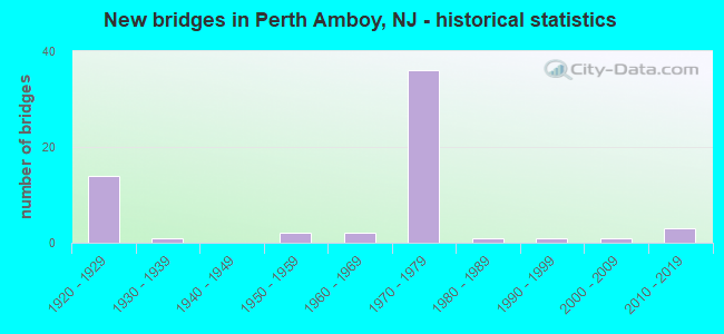
- New bridges - historical statistics
- 141920-1929
- 11930-1939
- 21950-1959
- 21960-1969
- 361970-1979
- 11980-1989
- 11990-1999
- 12000-2009
- 32010-2019

- Reconstructed bridges - Historical Statistics
- 31950-1959
- 11960-1969
- 01970-1979
- 11980-1989
- 31990-1999
- 22000-2009
- 22010-2019
- 12020-2022


- Bridge Condition - Deck
- 10.0%Very good
- 30.0%Good
- 16.7%Satisfactory
- 30.0%Fair
- 6.7%Poor
- 6.7%Serious

- Bridge Condition - Superstructure
- 3.3%Very good
- 30.0%Good
- 26.7%Satisfactory
- 30.0%Fair
- 6.7%Poor
- 3.3%Serious

- Bridge Condition - Substructure
- 30.0%Good
- 46.7%Satisfactory
- 16.7%Fair
- 6.7%Poor

- Bridge Condition - Channel
- 25.0%Very good
- 75.0%Good
Find on map >> Show street view
Structure Number: 121B051, Location: 0.18 miles north of CR654 (Lat: 40.538550, Lng: -74.261569), Route carried "on" structure: County highway 611, Year Built: 1991, Status: Open, Structure Length: 5.06m (16.60ft), Average Daily Traffic: 15,010 (year 2021), Truck Traffic: 4%, Average Future Daily Traffic: 18,315 (year 2041), Design Load: HS 20+Mod, Features Intersected: WOODBRIDGE CREEK
Minimum Vertical Clearance: 30+ m (98+ ft), Kilometerpoint: 3.524, Lanes on structure: 2, Owner: County Highway Agency, Approaching Roadway Width: 14.6m (47.9ft), Material/Design: Prestressed concrete, Design/Construction: Box Beam or Girders - Multiple, Number Of Spans In Main Unit: 2, Length of Maximum Span: 24.1m (79.1ft), Curb or Sidewalk Widths: Left: 1.4m (4.6ft), Right: 0.0m, Curb-To-Curb Width: 14.6m (47.9ft), Out-to-Out Width: 17.3m (56.8ft)
Condition: Deck: Good, Superstructure: Satisfactory, Substructure: Good, Channel: Good, Operating Rating: 73.5 metric tons, Method Used To Determine Operating Rating: Load Factor (LF), Inventory Rating: 44.5 metric tons, Method Used To Determine Inventory Rating: Load Factor (LF), Structural Evaluation: Equal to present minimum criteria, Deck Geometry: Superior to present desirable criteria, Waterway Adequacy: Equal to present desirable criteria, Approach Roadway Alignment: Better than present minimum criteria, Designated Inspection Frequency: Every 24 months, Underwater Inspection Frequency: Every 48 months, Inspection Date: May 2021, Underwater Inspection Date: August 2019, Deck Structure Type: Concrete Cast-file-Place, Wearing Surface/Protective System: Wearing Surface: Monolithic Concrete, Deck Protection: Epoxy Coated Reinforcing
Find on map >> Show street view
Structure Number: 121B055, Location: 0.37 miles north of CR654 (Lat: 40.541211, Lng: -74.273931), Route carried "on" structure: County highway 653, Year Built: 1979, Status: Open, Structure Length: 1.10m (3.61ft), Average Daily Traffic: 6,364 (year 2021), Truck Traffic: 3%, Average Future Daily Traffic: 7,766 (year 2041), Design Load: HS 20, Features Intersected: BRANCH OF WOODBRIDGE CR.
Minimum Vertical Clearance: 30+ m (98+ ft), Kilometerpoint: 3.009, Lanes on structure: 2, Owner: County Highway Agency, Approaching Roadway Width: 13.4m (44.0ft), Material/Design: Prestressed concrete, Design/Construction: Box Beam or Girders - Multiple, Number Of Spans In Main Unit: 1, Length of Maximum Span: 9.8m (32.2ft), Curb or Sidewalk Widths: Left: 0.2m (0.7ft), Right: 1.9m (6.2ft), Curb-To-Curb Width: 13.4m (44.0ft), Out-to-Out Width: 16.2m (53.1ft)
Condition: Deck: Fair, Superstructure: Fair, Substructure: Good, Channel: Good, Operating Rating: 58.1 metric tons, Method Used To Determine Operating Rating: Load Factor (LF), Inventory Rating: 34.5 metric tons, Method Used To Determine Inventory Rating: Load Factor (LF), Structural Evaluation: Somewhat better than minimum adequacy, Deck Geometry: Equal to present minimum criteria, Waterway Adequacy: Equal to present desirable criteria, Approach Roadway Alignment: Equal to present desirable criteria, Designated Inspection Frequency: Every 24 months, Inspection Date: May 2021, Deck Structure Type: Concrete Cast-file-Place, Wearing Surface/Protective System: Wearing Surface: Monolithic Concrete
Find on map >> Show street view
Structure Number: 122315, Location: 0.48mi NE of RT9&35 JCT (Lat: 40.503131, Lng: -74.295369), Route carried "on" structure: State highway 35, Year Built: 2005, Status: Open, Structure Length: 121.04m (397.11ft), Average Daily Traffic: 24,960 (year 2021), Truck Traffic: 4%, Average Future Daily Traffic: 30,450 (year 2041), Design Load: HS 25 or greater, Features Intersected: Raritan Rvr/Riverview Dr
Minimum Vertical Clearance: 30+ m (98+ ft), Kilometerpoint: 83.284, Lanes on structure: 4, Lanes under structure: 2, Base Highway Network: Yes, Owner: State Highway Agency, Approaching Roadway Width: 22.6m (74.1ft), Skew: 30 degrees, Navigation Control: Yes ( Vertical Clearance: 33.5m (109.9ft), Horizontal Clearance: 107.9m (354.0ft)), Material/Design: Prestressed concrete continuous, Design/Construction: Segmental Box Girder, Number Of Spans In Main Unit: 23, Length of Maximum Span: 134.1m (440.0ft), Curb or Sidewalk Widths: Left: 1.8m (5.9ft), Right: 0.0m, Curb-To-Curb Width: 22.6m (74.1ft), Out-to-Out Width: 26.2m (86.0ft)
Condition: Deck: Satisfactory, Superstructure: Satisfactory, Substructure: Good, Channel: Very good, Operating Rating: 68.9 metric tons, Method Used To Determine Operating Rating: Load Factor (LF), Inventory Rating: 40.8 metric tons, Method Used To Determine Inventory Rating: Load Factor (LF), Structural Evaluation: Equal to present minimum criteria, Deck Geometry: Superior to present desirable criteria, Underclear: Meets minimum limits, Waterway Adequacy: Superior to present desirable criteria, Approach Roadway Alignment: Equal to present desirable criteria, Designated Inspection Frequency: Every 24 months, Underwater Inspection Frequency: Every 48 months, Inspection Date: June 2021, Underwater Inspection Date: August 2021, Deck Structure Type: Concrete Precast Panels, Wearing Surface/Protective System: Wearing Surface: Monolithic Concrete, Deck Protection: Epoxy Coated Reinforcing
Find on map >> Show street view
Structure Number: 1223153, Location: 0.28 MI. N. OF C.R. 656 (Lat: 40.517281, Lng: -74.284731), Route carried "on" structure: State highway 35, Year Built: 1960, Year Reconstructed: 1972, Status: Temporarily open, Structure Length: 7.19m (23.59ft), Average Daily Traffic: 21,580 (year 2021), Truck Traffic: 4%, Average Future Daily Traffic: 25,895 (year 2041), Design Load: HS 20, Features Intersected: PERTH AMBOY CONN (RT440)
Minimum Vertical Clearance: 30+ m (98+ ft), Kilometerpoint: 84.426, Lanes on structure: 4, Lanes under structure: 4, Base Highway Network: Yes, Owner: State Highway Agency, Approaching Roadway Width: 14.0m (45.9ft), Material/Design: Prestressed concrete, Design/Construction: Box Beam or Girders - Multiple, Number Of Spans In Main Unit: 2, Number Of Approach Spans: 2, Length of Maximum Span: 15.5m (50.9ft), Curb or Sidewalk Widths: Left: 2.3m (7.5ft), Right: 2.3m (7.5ft), Curb-To-Curb Width: 14.0m (45.9ft), Out-to-Out Width: 19.3m (63.3ft)
Condition: Deck: Serious, Superstructure: Serious, Substructure: Fair, Operating Rating: 45.4 metric tons, Method Used To Determine Operating Rating: Field evaluation and documented engineering judgment, Inventory Rating: 27.2 metric tons, Method Used To Determine Inventory Rating: Field evaluation and documented engineering judgment, Structural Evaluation: High priority of corrective action, Deck Geometry: High priority of replacement, Underclear: Meets minimum limits, Approach Roadway Alignment: Equal to present minimum criteria, Length Of Structure Improvement: 8.20m (26.90ft), Designated Inspection Frequency: Every 24 months, Other Special Inspection Frequency: Every 12 months, Inspection Date: September 2021, Other Special Inspection Date: September 2021, Bridge Improvement Cost: $7,592,000, Roadway Improvement Cost: $760,000, Total Project Cost: $11,788,000 ( Estimate for 2021), Deck Structure Type: Concrete Precast Panels, Wearing Surface/Protective System: Wearing Surface: Bituminous, Membrane: Other
Find on map >> Show street view
Structure Number: 1232153, Location: 600 FT WNW OF 35/440 JCT (Lat: 40.529739, Lng: -74.281969), Route carried "on" structure: Ramp State highway 440, Year Built: 1972, Year Reconstructed: 2016, Status: Open, Structure Length: 2.62m (8.60ft), Average Daily Traffic: 6,901 (year 2021), Truck Traffic: 5%, Average Future Daily Traffic: 8,282 (year 2041), Design Load: HL 93, Features Intersected: NJ 35 RAMP "G"
Minimum Vertical Clearance: 30+ m (98+ ft), Kilometerpoint: 5.488, Lanes on structure: 1, Lanes under structure: 2, Owner: State Highway Agency, Approaching Roadway Width: 7.6m (24.9ft), Skew: 2 degrees, Material/Design: Steel, Design/Construction: Stringer/Multi-beam, Number Of Spans In Main Unit: 1, Length of Maximum Span: 24.4m (80.1ft), Curb-To-Curb Width: 7.6m (24.9ft), Out-to-Out Width: 8.7m (28.5ft)
Condition: Deck: Very good, Superstructure: Good, Substructure: Good, Operating Rating: 66.1 metric tons, Method Used To Determine Operating Rating: Load and Resistance Factor Rating (LRFR) rating reported by rating factor(RF) method using HL-93 loadings, Inventory Rating: 53.5 metric tons, Method Used To Determine Inventory Rating: Load and Resistance Factor Rating (LRFR) rating reported by rating factor(RF) method using HL-93 loadings, Structural Evaluation: Better than present minimum criteria, Deck Geometry: Better than present minimum criteria, Underclear: Meets minimum limits, Approach Roadway Alignment: Better than present minimum criteria, Designated Inspection Frequency: Every 24 months, Inspection Date: November 2021, Bridge Improvement Cost: $376,000, Roadway Improvement Cost: $110,000, Total Project Cost: $535,000 ( Estimate for 2016), Deck Structure Type: Concrete Cast-file-Place, Wearing Surface/Protective System: Wearing Surface: Monolithic Concrete
Find on map >> Show street view
Structure Number: 1232154, Location: AT JCT OF NJ440-NJ35 (Lat: 40.528861, Lng: -74.279869), Route carried "on" structure: State highway 35, Year Built: 1972, Status: Open, Structure Length: 8.38m (27.49ft), Average Daily Traffic: 22,917 (year 2021), Truck Traffic: 4%, Average Future Daily Traffic: 27,501 (year 2041), Design Load: HS 20+Mod, Features Intersected: NJ 440
Minimum Vertical Clearance: 30+ m (98+ ft), Kilometerpoint: 85.810, Lanes on structure: 5, Lanes under structure: 11, Base Highway Network: Yes, Owner: State Highway Agency, Approaching Roadway Width: 18.9m (62.0ft), Material/Design: Steel, Design/Construction: Stringer/Multi-beam, Number Of Spans In Main Unit: 2, Length of Maximum Span: 43.0m (141.1ft), Curb or Sidewalk Widths: Left: 2.4m (7.9ft), Right: 2.4m (7.9ft), Curb-To-Curb Width: 18.9m (62.0ft), Out-to-Out Width: 24.5m (80.4ft)
Condition: Deck: Good, Superstructure: Satisfactory, Substructure: Satisfactory, Operating Rating: 66.2 metric tons, Method Used To Determine Operating Rating: Load Factor (LF), Inventory Rating: 39.9 metric tons, Method Used To Determine Inventory Rating: Load Factor (LF), Structural Evaluation: Equal to present minimum criteria, Deck Geometry: Meets minimum limits, Underclear: High priority of corrective action, Approach Roadway Alignment: Equal to present desirable criteria, Length Of Structure Improvement: 8.38m (27.49ft), Designated Inspection Frequency: Every 24 months, Inspection Date: December 2021, Bridge Improvement Cost: $647,000, Roadway Improvement Cost: $238,000, Total Project Cost: $113,000 ( Estimate for 2021), Deck Structure Type: Concrete Cast-file-Place, Wearing Surface/Protective System: Wearing Surface: Bituminous
Find on map >> Show street view
Structure Number: 1232155, Location: 0.27 MI EAST OF ROUTE 35 (Lat: 40.528419, Lng: -74.275011), Route carried "on" structure: County highway 653, Year Built: 1972, Year Reconstructed: 2010, Status: Open, Structure Length: 4.05m (13.29ft), Average Daily Traffic: 6,300 (year 2020), Truck Traffic: 3%, Average Future Daily Traffic: 7,687 (year 2040), Design Load: HS 20, Features Intersected: NJ 440, Facility Carried by Structure: AMBOY AVE & U-TURN
Minimum Vertical Clearance: 30+ m (98+ ft), Kilometerpoint: 1.448, Lanes on structure: 4, Lanes under structure: 7, Owner: State Highway Agency, Approaching Roadway Width: 26.2m (86.0ft), Skew: 30 degrees, Material/Design: Steel, Design/Construction: Stringer/Multi-beam, Number Of Spans In Main Unit: 2, Length of Maximum Span: 20.7m (67.9ft), Curb or Sidewalk Widths: Left: 2.4m (7.9ft), Right: 2.4m (7.9ft), Curb-To-Curb Width: 26.9m (88.3ft), Out-to-Out Width: 33.3m (109.3ft)
Condition: Deck: Good, Superstructure: Fair, Substructure: Satisfactory, Inventory Rating: 62.6 metric tons, Method Used To Determine Inventory Rating: Load Factor (LF), Structural Evaluation: Somewhat better than minimum adequacy, Deck Geometry: Superior to present desirable criteria, Underclear: High priority of corrective action, Approach Roadway Alignment: Equal to present desirable criteria, Length Of Structure Improvement: 4.05m (13.29ft), Designated Inspection Frequency: Every 24 months, Inspection Date: April 2020, Roadway Improvement Cost: $521,000, Total Project Cost: $599,000 ( Estimate for 2020), Deck Structure Type: Concrete Cast-file-Place, Wearing Surface/Protective System: Wearing Surface: Monolithic Concrete, Deck Protection: Epoxy Coated Reinforcing
Find on map >> Show street view
Structure Number: 1232157, Location: JCT OUTERBRIDGE CROSSING (Lat: 40.525831, Lng: -74.268981), Route carried "on" structure: Ramp State highway 440, Year Built: 1972, Year Reconstructed: 2013, Status: Open, Structure Length: 47.91m (157.19ft), Average Daily Traffic: 9,635 (year 2021), Truck Traffic: 5%, Average Future Daily Traffic: 11,562 (year 2041), Design Load: HL 93, Features Intersected: Ramp/State/Bogg/Dill/NJT
Minimum Vertical Clearance: 4.62m (15.16ft), Kilometerpoint: 6.453, Lanes on structure: 2, Lanes under structure: 8, Owner: State Highway Agency, Approaching Roadway Width: 7.9m (25.9ft), Skew: 9 degrees, Material/Design: Steel, Design/Construction: Stringer/Multi-beam, Number Of Spans In Main Unit: 21, Length of Maximum Span: 26.2m (86.0ft), Curb-To-Curb Width: 9.3m (30.5ft), Out-to-Out Width: 11.4m (37.4ft)
Condition: Deck: Good, Superstructure: Fair, Substructure: Satisfactory, Operating Rating: 59.3 metric tons, Method Used To Determine Operating Rating: Load and Resistance Factor Rating (LRFR) rating reported by rating factor(RF) method using HL-93 loadings, Inventory Rating: 47.0 metric tons, Method Used To Determine Inventory Rating: Load and Resistance Factor Rating (LRFR) rating reported by rating factor(RF) method using HL-93 loadings, Structural Evaluation: Somewhat better than minimum adequacy, Deck Geometry: Meets minimum limits, Underclear: Somewhat better than minimum adequacy, Approach Roadway Alignment: Equal to present desirable criteria, Designated Inspection Frequency: Every 24 months, Inspection Date: April 2021, Deck Structure Type: Concrete Cast-file-Place, Wearing Surface/Protective System: Wearing Surface: Monolithic Concrete, Deck Protection: Epoxy Coated Reinforcing
Find on map >> Show street view
Structure Number: 1232158, Location: At OUTERBRIDGE CROSSING (Lat: 40.526381, Lng: -74.269019), Route carried "on" structure: Ramp State highway 440, Year Built: 1972, Status: Open, Structure Length: 43.25m (141.90ft), Average Daily Traffic: 10,717 (year 2021), Truck Traffic: 5%, Average Future Daily Traffic: 12,860 (year 2041), Design Load: HS 20+Mod, Features Intersected: Ramp/State/Bogg/Dill/NJT
Minimum Vertical Clearance: 5.31m (17.42ft), Kilometerpoint: 6.518, Lanes on structure: 2, Lanes under structure: 8, Owner: State Highway Agency, Approaching Roadway Width: 9.1m (29.9ft), Skew: 29 degrees, Material/Design: Steel, Design/Construction: Stringer/Multi-beam, Number Of Spans In Main Unit: 24, Length of Maximum Span: 27.7m (90.9ft), Curb or Sidewalk Widths: Left: 0.8m (2.6ft), Right: 0.8m (2.6ft), Curb-To-Curb Width: 9.1m (29.9ft), Out-to-Out Width: 11.3m (37.1ft)
Condition: Deck: Satisfactory, Superstructure: Fair, Substructure: Fair, Operating Rating: 47.2 metric tons, Method Used To Determine Operating Rating: Load Factor (LF), Inventory Rating: 28.1 metric tons, Method Used To Determine Inventory Rating: Load Factor (LF), Structural Evaluation: Somewhat better than minimum adequacy, Deck Geometry: Meets minimum limits, Underclear: Meets minimum limits, Approach Roadway Alignment: Better than present minimum criteria, Designated Inspection Frequency: Every 24 months, Inspection Date: April 2021, Deck Structure Type: Concrete Cast-file-Place, Wearing Surface/Protective System: Wearing Surface: Bituminous
Find on map >> Show street view
Structure Number: 123216, Location: OVER STATE ST (CR611) NB (Lat: 40.527400, Lng: -74.264369), Route carried "on" structure: Ramp State highway 440, Year Built: 1972, Status: Open, Structure Length: 2.83m (9.28ft), Average Daily Traffic: 3,692 (year 2021), Truck Traffic: 5%, Average Future Daily Traffic: 4,430 (year 2041), Design Load: HS 20, Features Intersected: STATE STREET (CR 611) NB
Minimum Vertical Clearance: 30+ m (98+ ft), Kilometerpoint: 6.856, Lanes on structure: 1, Lanes under structure: 1, Owner: State Highway Agency, Approaching Roadway Width: 6.7m (22.0ft), Skew: 5 degrees, Material/Design: Steel, Design/Construction: Stringer/Multi-beam, Number Of Spans In Main Unit: 1, Length of Maximum Span: 25.3m (83.0ft), Curb or Sidewalk Widths: Left: 0.5m (1.6ft), Right: 0.8m (2.6ft), Curb-To-Curb Width: 6.7m (22.0ft), Out-to-Out Width: 8.7m (28.5ft)
Condition: Deck: Fair, Superstructure: Good, Substructure: Satisfactory, Operating Rating: 48.1 metric tons, Method Used To Determine Operating Rating: Load Factor (LF), Inventory Rating: 29.0 metric tons, Method Used To Determine Inventory Rating: Load Factor (LF), Structural Evaluation: Equal to present minimum criteria, Deck Geometry: Equal to present minimum criteria, Underclear: Somewhat better than minimum adequacy, Approach Roadway Alignment: Somewhat better than minimum adequacy, Designated Inspection Frequency: Every 24 months, Inspection Date: May 2021, Deck Structure Type: Concrete Cast-file-Place, Wearing Surface/Protective System: Wearing Surface: Latex Concrete
Find on map >> Show street view
Structure Number: 1232161, Location: NJ440 MP4.26 StateSt Exit (Lat: 40.526619, Lng: -74.262669), Route carried "on" structure: Ramp State highway 440, Year Built: 2013, Status: Open, Structure Length: 4.91m (16.11ft), Average Daily Traffic: 5,380 (year 2021), Truck Traffic: 5%, Average Future Daily Traffic: 6,570 (year 2041), Design Load: HS 25 or greater, Features Intersected: NJ 440 Ramp U and ramp V
Minimum Vertical Clearance: 30+ m (98+ ft), Kilometerpoint: 6.856, Lanes on structure: 2, Lanes under structure: 4, Base Highway Network: Yes, Owner: State Highway Agency, Approaching Roadway Width: 11.4m (37.4ft), Skew: 5 degrees, Material/Design: Steel continuous, Design/Construction: Stringer/Multi-beam, Number Of Spans In Main Unit: 2, Length of Maximum Span: 31.4m (103.0ft), Curb-To-Curb Width: 11.4m (37.4ft), Out-to-Out Width: 12.5m (41.0ft)
Condition: Deck: Good, Superstructure: Very good, Substructure: Good, Operating Rating: 63.5 metric tons, Method Used To Determine Operating Rating: Load and Resistance Factor Rating (LRFR) rating reported by rating factor(RF) method using HL-93 loadings, Inventory Rating: 48.9 metric tons, Method Used To Determine Inventory Rating: Load and Resistance Factor Rating (LRFR) rating reported by rating factor(RF) method using HL-93 loadings, Structural Evaluation: Better than present minimum criteria, Deck Geometry: Superior to present desirable criteria, Underclear: Equal to present minimum criteria, Approach Roadway Alignment: Equal to present desirable criteria, Designated Inspection Frequency: Every 24 months, Inspection Date: March 2021, Deck Structure Type: Concrete Cast-file-Place, Wearing Surface/Protective System: Deck Protection: Galvanized Reinforcing
Find on map >> Show street view
Structure Number: 123417, Location: 0.25 MI NORTH OF RT440 (Lat: 40.520950, Lng: -74.301450), Route carried "on" structure: US 9, Year Built: 1972, Year Reconstructed: 2020, Status: Open, Structure Length: 3.26m (10.70ft), Average Daily Traffic: 46,120 (year 2020), Truck Traffic: 5%, Average Future Daily Traffic: 55,344 (year 2040), Design Load: HL 93, Features Intersected: US 9 RAMP GM
Minimum Vertical Clearance: 30+ m (98+ ft), Kilometerpoint: 214.027, Lanes on structure: 3, Lanes under structure: 2, Base Highway Network: Yes, Owner: State Highway Agency, Approaching Roadway Width: 14.9m (48.9ft), Skew: 5 degrees, Material/Design: Steel, Design/Construction: Stringer/Multi-beam, Number Of Spans In Main Unit: 1, Length of Maximum Span: 29.9m (98.1ft), Curb-To-Curb Width: 15.6m (51.2ft), Out-to-Out Width: 16.6m (54.5ft)
Condition: Deck: Very good, Superstructure: Good, Substructure: Good, Operating Rating: 33.0 metric tons, Method Used To Determine Operating Rating: Load and Resistance Factor Rating (LRFR) rating reported by rating factor(RF) method using HL-93 loadings, Inventory Rating: 25.3 metric tons, Method Used To Determine Inventory Rating: Load and Resistance Factor Rating (LRFR) rating reported by rating factor(RF) method using HL-93 loadings, Structural Evaluation: Equal to present minimum criteria, Deck Geometry: Equal to present minimum criteria, Underclear: Meets minimum limits, Approach Roadway Alignment: Better than present minimum criteria, Length Of Structure Improvement: 3.26m (10.70ft), Designated Inspection Frequency: Every 24 months, Inspection Date: April 2020, Bridge Improvement Cost: $1,458,000, Total Project Cost: $1,837,000 ( Estimate for 2018), Deck Structure Type: Concrete Cast-file-Place, Wearing Surface/Protective System: Wearing Surface: Monolithic Concrete, Deck Protection: Epoxy Coated Reinforcing
Find on map >> Show street view
Structure Number: 1234173, Location: 0.20 MI EAST OF US9 (Lat: 40.515631, Lng: -74.296800), Route carried "on" structure: County highway 656, Year Built: 1972, Year Reconstructed: 2012, Status: Open, Structure Length: 2.99m (9.81ft), Average Daily Traffic: 25,455 (year 2020), Truck Traffic: 4%, Average Future Daily Traffic: 30,547 (year 2040), Design Load: HS 20, Features Intersected: RAMP FOR US 9 & NJ 440
Minimum Vertical Clearance: 30+ m (98+ ft), Kilometerpoint: 2.849, Lanes on structure: 5, Lanes under structure: 2, Owner: State Highway Agency, Approaching Roadway Width: 22.3m (73.2ft), Skew: 22 degrees, Material/Design: Steel, Design/Construction: Stringer/Multi-beam, Number Of Spans In Main Unit: 1, Length of Maximum Span: 28.0m (91.9ft), Curb or Sidewalk Widths: Left: 1.8m (5.9ft), Right: 0.0m, Curb-To-Curb Width: 22.3m (73.2ft), Out-to-Out Width: 26.3m (86.3ft)
Condition: Deck: Very good, Superstructure: Good, Substructure: Good, Operating Rating: 47.2 metric tons, Method Used To Determine Operating Rating: Load Factor (LF), Inventory Rating: 28.1 metric tons, Method Used To Determine Inventory Rating: Load Factor (LF), Structural Evaluation: Better than present minimum criteria, Deck Geometry: Equal to present minimum criteria, Underclear: Meets minimum limits, Approach Roadway Alignment: Equal to present desirable criteria, Designated Inspection Frequency: Every 24 months, Inspection Date: April 2020, Roadway Improvement Cost: $250,000, Total Project Cost: $300,000 ( Estimate for 2020), Deck Structure Type: Concrete Cast-file-Place, Wearing Surface/Protective System: Wearing Surface: Monolithic Concrete
Find on map >> Show street view
Structure Number: 1234177, Location: 0.65 MI EAST OF GSP (Lat: 40.522800, Lng: -74.291150), Route carried "on" structure: County highway 616, Year Built: 1972, Status: Open, Structure Length: 6.46m (21.19ft), Average Daily Traffic: 15,402 (year 2021), Truck Traffic: 4%, Average Future Daily Traffic: 18,482 (year 2041), Design Load: HS 20+Mod, Features Intersected: NJ 440 & RAMP TO 440N, Facility Carried by Structure: NEW BRUNSWICK AVE.
Minimum Vertical Clearance: 30+ m (98+ ft), Kilometerpoint: 2.237, Lanes on structure: 2, Lanes under structure: 7, Owner: State Highway Agency, Approaching Roadway Width: 14.0m (45.9ft), Skew: 1 degrees, Material/Design: Steel, Design/Construction: Stringer/Multi-beam, Number Of Spans In Main Unit: 2, Length of Maximum Span: 34.1m (111.9ft), Curb or Sidewalk Widths: Left: 2.4m (7.9ft), Right: 2.4m (7.9ft), Curb-To-Curb Width: 14.0m (45.9ft), Out-to-Out Width: 19.7m (64.6ft)
Condition: Deck: Fair, Superstructure: Good, Substructure: Satisfactory, Operating Rating: 47.2 metric tons, Method Used To Determine Operating Rating: Load Factor (LF), Inventory Rating: 28.1 metric tons, Method Used To Determine Inventory Rating: Load Factor (LF), Structural Evaluation: Equal to present minimum criteria, Deck Geometry: Superior to present desirable criteria, Underclear: High priority of corrective action, Approach Roadway Alignment: Better than present minimum criteria, Length Of Structure Improvement: 6.46m (21.19ft), Designated Inspection Frequency: Every 24 months, Inspection Date: May 2021, Roadway Improvement Cost: $286,000, Total Project Cost: $329,000 ( Estimate for 2021), Deck Structure Type: Concrete Cast-file-Place, Wearing Surface/Protective System: Wearing Surface: Monolithic Concrete
Find on map >> Show street view
Structure Number: 1234178, Location: 0.81 MI EAST OF GSP (Lat: 40.525119, Lng: -74.289289), Route carried "on" structure: County highway 655, Year Built: 1972, Year Reconstructed: 1995, Status: Open, Structure Length: 5.12m (16.80ft), Average Daily Traffic: 8,696 (year 2021), Truck Traffic: 3%, Average Future Daily Traffic: 10,435 (year 2041), Design Load: HS 20, Features Intersected: NJ 440
Minimum Vertical Clearance: 30+ m (98+ ft), Kilometerpoint: 0.892, Lanes on structure: 4, Lanes under structure: 7, Owner: State Highway Agency, Approaching Roadway Width: 14.0m (45.9ft), Skew: 3 degrees, Material/Design: Steel, Design/Construction: Stringer/Multi-beam, Number Of Spans In Main Unit: 2, Length of Maximum Span: 26.2m (86.0ft), Curb or Sidewalk Widths: Left: 2.4m (7.9ft), Right: 2.4m (7.9ft), Curb-To-Curb Width: 14.0m (45.9ft), Out-to-Out Width: 19.7m (64.6ft)
Condition: Deck: Satisfactory, Superstructure: Satisfactory, Substructure: Satisfactory, Operating Rating: 60.8 metric tons, Method Used To Determine Operating Rating: Load Factor (LF), Inventory Rating: 36.3 metric tons, Method Used To Determine Inventory Rating: Load Factor (LF), Structural Evaluation: Equal to present minimum criteria, Deck Geometry: High priority of replacement, Underclear: High priority of corrective action, Approach Roadway Alignment: Equal to present minimum criteria, Length Of Structure Improvement: 5.12m (16.80ft), Designated Inspection Frequency: Every 24 months, Inspection Date: June 2021, Bridge Improvement Cost: $2,358,000, Roadway Improvement Cost: $300,000, Total Project Cost: $2,658,000 ( Estimate for 2021), Deck Structure Type: Concrete Cast-file-Place, Wearing Surface/Protective System: Wearing Surface: Latex Concrete
Find on map >> Show street view
Structure Number: 1234179, Location: 1.05 MI N OF US 9 JCT (Lat: 40.528189, Lng: -74.285700), Route carried "on" structure: City street , Year Built: 1972, Status: Open, Structure Length: 6.89m (22.60ft), Average Daily Traffic: 1,173 (year 2021), Truck Traffic: 1%, Average Future Daily Traffic: 1,408 (year 2041), Design Load: HS 20, Features Intersected: NJ 440, Facility Carried by Structure: CARLOCK AVENUE
Minimum Vertical Clearance: 30+ m (98+ ft), Kilometerpoint: 0.000, Lanes on structure: 2, Lanes under structure: 10, Owner: State Highway Agency, Approaching Roadway Width: 9.1m (29.9ft), Skew: 3 degrees, Material/Design: Steel, Design/Construction: Stringer/Multi-beam, Number Of Spans In Main Unit: 2, Length of Maximum Span: 36.0m (118.1ft), Curb or Sidewalk Widths: Left: 2.4m (7.9ft), Right: 2.4m (7.9ft), Curb-To-Curb Width: 9.1m (29.9ft), Out-to-Out Width: 14.8m (48.6ft)
Condition: Deck: Satisfactory, Superstructure: Good, Substructure: Satisfactory, Operating Rating: 67.1 metric tons, Method Used To Determine Operating Rating: Load Factor (LF), Inventory Rating: 39.9 metric tons, Method Used To Determine Inventory Rating: Load Factor (LF), Structural Evaluation: Equal to present minimum criteria, Deck Geometry: Somewhat better than minimum adequacy, Underclear: Meets minimum limits, Approach Roadway Alignment: Equal to present minimum criteria, Designated Inspection Frequency: Every 24 months, Inspection Date: July 2021, Deck Structure Type: Concrete Cast-file-Place, Wearing Surface/Protective System: Wearing Surface: Monolithic Concrete
Find on map >> Show street view
Structure Number: 124115, Location: At JCT of NJ 184 & US 9 (Lat: 40.534539, Lng: -74.297361), Route carried "on" structure: State highway 184, Year Built: 1938, Status: Open, Structure Length: 3.14m (10.30ft), Average Daily Traffic: 29,088 (year 2021), Truck Traffic: 4%, Average Future Daily Traffic: 35,525 (year 2041), Features Intersected: US 9
Minimum Vertical Clearance: 30+ m (98+ ft), Kilometerpoint: 0.547, Lanes on structure: 4, Lanes under structure: 6, Base Highway Network: Yes, Owner: State Highway Agency, Approaching Roadway Width: 12.2m (40.0ft), Material/Design: Steel, Design/Construction: Stringer/Multi-beam, Number Of Spans In Main Unit: 2, Length of Maximum Span: 14.9m (48.9ft), Curb or Sidewalk Widths: Left: 1.6m (5.2ft), Right: 1.6m (5.2ft), Curb-To-Curb Width: 12.2m (40.0ft), Out-to-Out Width: 16.9m (55.4ft)
Condition: Deck: Fair, Superstructure: Satisfactory, Substructure: Satisfactory, Operating Rating: 66.2 metric tons, Method Used To Determine Operating Rating: Load Factor (LF), Inventory Rating: 39.0 metric tons, Method Used To Determine Inventory Rating: Load Factor (LF), Structural Evaluation: Equal to present minimum criteria, Deck Geometry: High priority of replacement, Underclear: Meets minimum limits, Approach Roadway Alignment: Better than present minimum criteria, Length Of Structure Improvement: 3.14m (10.30ft), Designated Inspection Frequency: Every 24 months, Inspection Date: April 2021, Bridge Improvement Cost: $294,000, Roadway Improvement Cost: $197,000, Total Project Cost: $800,000 ( Estimate for 2021), Deck Structure Type: Concrete Cast-file-Place, Wearing Surface/Protective System: Wearing Surface: Bituminous
Find on map >> Show street view
Structure Number: 1241151, Location: 1.1 MI E. OF GSP (Lat: 40.528581, Lng: -74.282939), Route carried "on" structure: State highway 184, Year Built: 1972, Status: Open, Structure Length: 6.89m (22.60ft), Average Daily Traffic: 12,030 (year 2020), Truck Traffic: 4%, Average Future Daily Traffic: 14,680 (year 2040), Design Load: HS 20+Mod, Features Intersected: NJ 440
Minimum Vertical Clearance: 30+ m (98+ ft), Kilometerpoint: 1.915, Lanes on structure: 3, Lanes under structure: 8, Base Highway Network: Yes, Owner: State Highway Agency, Approaching Roadway Width: 11.6m (38.1ft), Skew: 2 degrees, Material/Design: Steel, Design/Construction: Stringer/Multi-beam, Number Of Spans In Main Unit: 2, Length of Maximum Span: 39.6m (129.9ft), Curb or Sidewalk Widths: Left: 0.8m (2.6ft), Right: 2.4m (7.9ft), Curb-To-Curb Width: 11.6m (38.1ft), Out-to-Out Width: 15.5m (50.9ft)
Condition: Deck: Good, Superstructure: Satisfactory, Substructure: Good, Operating Rating: 45.4 metric tons, Method Used To Determine Operating Rating: Load Factor (LF), Inventory Rating: 27.2 metric tons, Method Used To Determine Inventory Rating: Load Factor (LF), Structural Evaluation: Equal to present minimum criteria, Deck Geometry: High priority of replacement, Underclear: High priority of corrective action, Approach Roadway Alignment: Somewhat better than minimum adequacy, Length Of Structure Improvement: 6.89m (22.60ft), Designated Inspection Frequency: Every 24 months, Inspection Date: September 2020, Bridge Improvement Cost: $1,397,000, Roadway Improvement Cost: $313,000, Total Project Cost: $2,188,000 ( Estimate for 2020), Deck Structure Type: Concrete Cast-file-Place, Wearing Surface/Protective System: Wearing Surface: Bituminous, Membrane: Other
Find on map >> Show street view
Structure Number: 1254161, Location: 0.6MI NW OF US1&I287 JCT (Lat: 40.536631, Lng: -74.360061), Route carried "on" structure: County highway 531, Year Built: 1929, Year Reconstructed: 1998, Status: Open, Structure Length: 3.23m (10.60ft), Average Daily Traffic: 15,483 (year 2021), Truck Traffic: 4%, Average Future Daily Traffic: 18,892 (year 2041), Design Load: HS 20+Mod, Features Intersected: P.AMBOY-S.PLAINFIELD BR.
Minimum Vertical Clearance: 30+ m (98+ ft), Kilometerpoint: 2.398, Lanes on structure: 2, Base Highway Network: Yes, Maintenance Responsibility: State Highway Agency, Approaching Roadway Width: 12.5m (41.0ft), Skew: 2 degrees, Material/Design: Steel, Design/Construction: Stringer/Multi-beam, Number Of Spans In Main Unit: 3, Length of Maximum Span: 12.2m (40.0ft), Curb or Sidewalk Widths: Left: 1.8m (5.9ft), Right: 1.8m (5.9ft), Curb-To-Curb Width: 12.2m (40.0ft), Out-to-Out Width: 16.5m (54.1ft)
Condition: Deck: Good, Superstructure: Good, Substructure: Satisfactory, Operating Rating: 60.8 metric tons, Method Used To Determine Operating Rating: Load Factor (LF), Inventory Rating: 26.3 metric tons, Method Used To Determine Inventory Rating: Load Factor (LF), Structural Evaluation: Equal to present minimum criteria, Deck Geometry: Somewhat better than minimum adequacy, Approach Roadway Alignment: Equal to present desirable criteria, Designated Inspection Frequency: Every 24 months, Critical Feature Inspection Frequency: Every 24 months, Inspection Date: September 2021, Critical Feature Inspection Date: September 2021, Deck Structure Type: Concrete Cast-file-Place, Wearing Surface/Protective System: Wearing Surface: Latex Concrete, Deck Protection: Epoxy Coated Reinforcing
Find on map >> Show street view
Structure Number: 1254165, Location: 0.57MI E OF US9&NJ440 JCT (Lat: 40.520381, Lng: -74.290281), Route carried "on" structure: County highway 655, Year Built: 1985, Status: Open, Structure Length: 3.57m (11.71ft), Average Daily Traffic: 8,365 (year 2021), Truck Traffic: 3%, Average Future Daily Traffic: 10,207 (year 2041), Design Load: HS 20+Mod, Features Intersected: PERTH AMBOY BRANCH
Minimum Vertical Clearance: 30+ m (98+ ft), Kilometerpoint: 0.386, Lanes on structure: 2, Maintenance Responsibility: State Highway Agency, Approaching Roadway Width: 9.1m (29.9ft), Skew: 1 degrees, Material/Design: Prestressed concrete, Design/Construction: Slab, Number Of Spans In Main Unit: 3, Length of Maximum Span: 15.2m (49.9ft), Curb or Sidewalk Widths: Left: 1.8m (5.9ft), Right: 1.8m (5.9ft), Curb-To-Curb Width: 9.1m (29.9ft), Out-to-Out Width: 13.4m (44.0ft)
Condition: Deck: Good, Superstructure: Good, Substructure: Good, Inventory Rating: 49.9 metric tons, Method Used To Determine Inventory Rating: Load Factor (LF), Structural Evaluation: Better than present minimum criteria, Deck Geometry: High priority of corrective action, Underclear: Equal to present minimum criteria, Approach Roadway Alignment: Better than present minimum criteria, Length Of Structure Improvement: 3.57m (11.71ft), Designated Inspection Frequency: Every 24 months, Inspection Date: September 2021, Bridge Improvement Cost: $92,000, Roadway Improvement Cost: $56,000, Total Project Cost: $260,000 ( Estimate for 2021), Deck Structure Type: Concrete Cast-file-Place, Wearing Surface/Protective System: Wearing Surface: Monolithic Concrete, Deck Protection: Epoxy Coated Reinforcing
Find on map >> Show street view
Structure Number: 126115, Location: .7 MI EAST OF NJ 35 (Lat: 40.520081, Lng: -74.268711), Route carried "on" structure: City street , Year Built: 1926, Status: Posted for load, Structure Length: 3.87m (12.70ft), Average Daily Traffic: 10,287 (year 2020), Truck Traffic: 3%, Average Future Daily Traffic: 12,345 (year 2040), Design Load: H 20, Features Intersected: NORTH JERSEY COAST LINE, Facility Carried by Structure: HALL AVENUE
Minimum Vertical Clearance: 30+ m (98+ ft), Kilometerpoint: 0.917, Lanes on structure: 2, Owner: State Agenciy, Approaching Roadway Width: 12.2m (40.0ft), Material/Design: Steel, Design/Construction: Girder and Floorbeam System, Number Of Spans In Main Unit: 3, Length of Maximum Span: 23.2m (76.1ft), Curb or Sidewalk Widths: Left: 2.7m (8.9ft), Right: 2.7m (8.9ft), Curb-To-Curb Width: 12.1m (39.7ft), Out-to-Out Width: 12.8m (42.0ft)
Condition: Deck: Fair, Superstructure: Fair, Substructure: Fair, Operating Rating: 44.5 metric tons, Method Used To Determine Operating Rating: Load Factor (LF), Inventory Rating: 26.3 metric tons, Method Used To Determine Inventory Rating: Load Factor (LF), Structural Evaluation: Somewhat better than minimum adequacy, Deck Geometry: Somewhat better than minimum adequacy, Underclear: Meets minimum limits, Approach Roadway Alignment: Better than present minimum criteria, Designated Inspection Frequency: Every 24 months, Critical Feature Inspection Frequency: Every 24 months, Inspection Date: September 2020, Critical Feature Inspection Date: September 2020, Deck Structure Type: Concrete Cast-file-Place, Wearing Surface/Protective System: Wearing Surface: Bituminous
Find on map >> Show street view
Structure Number: 1261151, Location: 0.32 N. of State Street (Lat: 40.515161, Lng: -74.270800), Route carried "on" structure: City street , Year Built: 1926, Year Reconstructed: 1988, Status: Open, Structure Length: 2.35m (7.71ft), Average Daily Traffic: 13,531 (year 2020), Truck Traffic: 1%, Average Future Daily Traffic: 16,237 (year 2040), Design Load: HS 20+Mod, Features Intersected: NORTH JERSEY COAST LINE, Facility Carried by Structure: WASHINGTON STREET
Minimum Vertical Clearance: 30+ m (98+ ft), Kilometerpoint: 0.724, Lanes on structure: 2, Owner: State Agenciy, Approaching Roadway Width: 12.2m (40.0ft), Material/Design: Prestressed concrete, Design/Construction: Box Beam or Girders - Multiple, Number Of Spans In Main Unit: 1, Length of Maximum Span: 22.3m (73.2ft), Curb or Sidewalk Widths: Left: 1.9m (6.2ft), Right: 1.9m (6.2ft), Curb-To-Curb Width: 12.3m (40.4ft), Out-to-Out Width: 16.7m (54.8ft)
Condition: Deck: Good, Superstructure: Good, Substructure: Satisfactory, Operating Rating: 84.4 metric tons, Method Used To Determine Operating Rating: Load Factor (LF), Inventory Rating: 50.8 metric tons, Method Used To Determine Inventory Rating: Load Factor (LF), Structural Evaluation: Equal to present minimum criteria, Deck Geometry: Somewhat better than minimum adequacy, Underclear: High priority of corrective action, Approach Roadway Alignment: Equal to present desirable criteria, Length Of Structure Improvement: 2.35m (7.71ft), Designated Inspection Frequency: Every 24 months, Inspection Date: September 2020, Bridge Improvement Cost: $494,000, Roadway Improvement Cost: $165,000, Total Project Cost: $1,043,000 ( Estimate for 2020), Deck Structure Type: Concrete Cast-file-Place, Wearing Surface/Protective System: Wearing Surface: Monolithic Concrete, Deck Protection: Epoxy Coated Reinforcing
Find on map >> Show street view
Structure Number: 1261153, Location: .8 MILE EAST OF NJ 35 (Lat: 40.512889, Lng: -74.271761), Route carried "on" structure: County highway 616, Year Built: 1926, Status: Open, Structure Length: 4.30m (14.11ft), Average Daily Traffic: 15,459 (year 2020), Truck Traffic: 4%, Average Future Daily Traffic: 18,551 (year 2040), Design Load: H 20, Features Intersected: NORTH JERSEY COAST LINE
Minimum Vertical Clearance: 30+ m (98+ ft), Kilometerpoint: 4.233, Lanes on structure: 2, Owner: State Agenciy, Approaching Roadway Width: 12.2m (40.0ft), Skew: 1 degrees, Material/Design: Steel, Design/Construction: Girder and Floorbeam System, Number Of Spans In Main Unit: 3, Length of Maximum Span: 24.4m (80.1ft), Curb or Sidewalk Widths: Left: 3.0m (9.8ft), Right: 3.0m (9.8ft), Curb-To-Curb Width: 12.1m (39.7ft), Out-to-Out Width: 12.8m (42.0ft)
Condition: Deck: Fair, Superstructure: Fair, Substructure: Fair, Operating Rating: 26.3 metric tons, Method Used To Determine Operating Rating: Load Factor (LF), Inventory Rating: 15.4 metric tons, Method Used To Determine Inventory Rating: Load Factor (LF), Structural Evaluation: High priority of corrective action, Deck Geometry: Somewhat better than minimum adequacy, Underclear: High priority of corrective action, Approach Roadway Alignment: Equal to present desirable criteria, Length Of Structure Improvement: 4.30m (14.11ft), Designated Inspection Frequency: Every 24 months, Critical Feature Inspection Frequency: Every 24 months, Inspection Date: September 2020, Critical Feature Inspection Date: September 2020, Bridge Improvement Cost: $1,224,000, Roadway Improvement Cost: $175,000, Total Project Cost: $2,152,000 ( Estimate for 2020), Deck Structure Type: Concrete Cast-file-Place, Wearing Surface/Protective System: Wearing Surface: Bituminous
Find on map >> Show street view
Structure Number: 1261154, Location: 0.75 MI EAST OF RT 35 JCT (Lat: 40.511839, Lng: -74.272769), Route carried "on" structure: City street , Year Built: 1928, Status: Open, Structure Length: 3.51m (11.52ft), Average Daily Traffic: 11,227 (year 2021), Truck Traffic: 1%, Average Future Daily Traffic: 13,697 (year 2041), Features Intersected: NORTH JERSEY COAST LINE, Facility Carried by Structure: FAYETTE STREET
Minimum Vertical Clearance: 30+ m (98+ ft), Kilometerpoint: 0.000, Lanes on structure: 2, Owner: City or Municipal Highway Agency, Approaching Roadway Width: 11.9m (39.0ft), Material/Design: Steel, Design/Construction: Girder and Floorbeam System, Number Of Spans In Main Unit: 2, Length of Maximum Span: 24.1m (79.1ft), Curb or Sidewalk Widths: Left: 3.3m (10.8ft), Right: 3.2m (10.5ft), Curb-To-Curb Width: 12.1m (39.7ft), Out-to-Out Width: 13.3m (43.6ft)
Condition: Deck: Serious, Superstructure: Fair, Substructure: Poor, Operating Rating: 44.5 metric tons, Method Used To Determine Operating Rating: Field evaluation and documented engineering judgment, Inventory Rating: 32.7 metric tons, Method Used To Determine Inventory Rating: Field evaluation and documented engineering judgment, Structural Evaluation: Meets minimum limits, Deck Geometry: Somewhat better than minimum adequacy, Underclear: High priority of replacement, Approach Roadway Alignment: Equal to present minimum criteria, Length Of Structure Improvement: 4.39m (14.40ft), Designated Inspection Frequency: Every 24 months, Critical Feature Inspection Frequency: Every 24 months, Inspection Date: June 2021, Critical Feature Inspection Date: June 2021, Bridge Improvement Cost: $4,885,000, Roadway Improvement Cost: $250,000, Total Project Cost: $8,716,000 ( Estimate for 2021), Deck Structure Type: Concrete Cast-file-Place, Wearing Surface/Protective System: Wearing Surface: Bituminous
Find on map >> Show street view
Structure Number: 1261156, Location: 1.07 MILE EAST OF NJ 35 (Lat: 40.510111, Lng: -74.273561), Route carried "on" structure: County highway 656, Year Built: 1926, Status: Open, Structure Length: 2.80m (9.19ft), Average Daily Traffic: 15,177 (year 2020), Truck Traffic: 4%, Average Future Daily Traffic: 18,212 (year 2040), Features Intersected: NORTH JERSEY COAST LINE
Minimum Vertical Clearance: 30+ m (98+ ft), Kilometerpoint: 5.761, Lanes on structure: 2, Owner: State Agenciy, Approaching Roadway Width: 11.9m (39.0ft), Material/Design: Steel, Design/Construction: Girder and Floorbeam System, Number Of Spans In Main Unit: 1, Length of Maximum Span: 24.4m (80.1ft), Curb or Sidewalk Widths: Left: 3.0m (9.8ft), Right: 3.0m (9.8ft), Curb-To-Curb Width: 12.1m (39.7ft), Out-to-Out Width: 12.7m (41.7ft)
Condition: Deck: Poor, Superstructure: Poor, Substructure: Satisfactory, Operating Rating: 46.3 metric tons, Method Used To Determine Operating Rating: Load Factor (LF), Inventory Rating: 27.2 metric tons, Method Used To Determine Inventory Rating: Load Factor (LF), Structural Evaluation: Meets minimum limits, Deck Geometry: Somewhat better than minimum adequacy, Underclear: High priority of replacement, Approach Roadway Alignment: Somewhat better than minimum adequacy, Length Of Structure Improvement: 3.51m (11.52ft), Designated Inspection Frequency: Every 24 months, Critical Feature Inspection Frequency: Every 24 months, Inspection Date: September 2020, Critical Feature Inspection Date: September 2020, Bridge Improvement Cost: $3,597,000, Roadway Improvement Cost: $469,000, Total Project Cost: $6,116,000 ( Estimate for 2020), Deck Structure Type: Concrete Cast-file-Place, Wearing Surface/Protective System: Wearing Surface: Bituminous
Find on map >> Show street view
Structure Number: 1261158, Location: 0.76 M. E. OF NJ 35/SMITH (Lat: 40.508561, Lng: -74.274419), Route carried "on" structure: County highway 658, Year Built: 1927, Status: Open, Structure Length: 3.90m (12.80ft), Average Daily Traffic: 11,749 (year 2020), Truck Traffic: 3%, Average Future Daily Traffic: 14,099 (year 2020), Features Intersected: NORTH JERSEY COAST LINE
Minimum Vertical Clearance: 30+ m (98+ ft), Kilometerpoint: 1.175, Lanes on structure: 2, Owner: State Agenciy, Approaching Roadway Width: 12.2m (40.0ft), Material/Design: Steel, Design/Construction: Girder and Floorbeam System, Number Of Spans In Main Unit: 3, Length of Maximum Span: 21.9m (71.9ft), Curb or Sidewalk Widths: Left: 3.0m (9.8ft), Right: 3.0m (9.8ft), Curb-To-Curb Width: 12.0m (39.4ft), Out-to-Out Width: 12.9m (42.3ft)
Condition: Deck: Poor, Superstructure: Poor, Substructure: Poor, Operating Rating: 42.6 metric tons, Method Used To Determine Operating Rating: Load Factor (LF), Inventory Rating: 25.4 metric tons, Method Used To Determine Inventory Rating: Load Factor (LF), Structural Evaluation: Meets minimum limits, Deck Geometry: Somewhat better than minimum adequacy, Underclear: High priority of replacement, Approach Roadway Alignment: Better than present minimum criteria, Length Of Structure Improvement: 4.82m (15.81ft), Designated Inspection Frequency: Every 24 months, Critical Feature Inspection Frequency: Every 24 months, Inspection Date: September 2020, Critical Feature Inspection Date: September 2020, Bridge Improvement Cost: $4,296,000, Roadway Improvement Cost: $860,000, Total Project Cost: $8,950,000 ( Estimate for 2020), Deck Structure Type: Concrete Cast-file-Place, Wearing Surface/Protective System: Wearing Surface: Bituminous
Find on map >> Show street view
Structure Number: 3823069, Location: 3 miles north of NJ TRPK (Lat: 40.524981, Lng: -74.243950), Route carried "on" structure: State highway 440, Year Built: 1928, Year Reconstructed: 1962, Status: Open, Structure Length: 64.01m (210.01ft), Average Daily Traffic: 83,856 (year 2014), Truck Traffic: 2%, Average Future Daily Traffic: 93,080 (year 2037), Design Load: HS 20, Features Intersected: Arthur Kill
Minimum Vertical Clearance: 5.92m (19.42ft), Kilometerpoint: 8.288, Lanes on structure: 4, Toll: Toll bridge, Owner: Private, Approaching Roadway Width: 15.2m (49.9ft), Skew: 30 degrees, Navigation Control: Yes ( Vertical Clearance: 41.1m (134.8ft), Horizontal Clearance: 205.7m (674.9ft)), Material/Design: Steel, Design/Construction: Truss - Thru, Number Of Spans In Main Unit: 5, Length of Maximum Span: 228.6m (750.0ft), Curb or Sidewalk Widths: Left: 1.6m (5.2ft), Right: 1.6m (5.2ft), Curb-To-Curb Width: 12.2m (40.0ft), Out-to-Out Width: 13.7m (44.9ft)
Condition: Deck: Satisfactory, Superstructure: Fair, Substructure: Satisfactory, Channel: Good, Operating Rating: 54.4 metric tons, Method Used To Determine Operating Rating: Load Factor (LF), Inventory Rating: 31.8 metric tons, Method Used To Determine Inventory Rating: Load Factor (LF), Structural Evaluation: Somewhat better than minimum adequacy, Deck Geometry: High priority of replacement, Waterway Adequacy: Superior to present desirable criteria, Approach Roadway Alignment: Equal to present minimum criteria, Length Of Structure Improvement: 70.41m (231.00ft), Designated Inspection Frequency: Every 24 months, Critical Feature Inspection Frequency: Every 24 months, Underwater Inspection Frequency: Every 48 months, Inspection Date: August 2020, Critical Feature Inspection Date: August 2020, Underwater Inspection Date: September 2018, Roadway Improvement Cost: $100,000, Total Project Cost: $75,075,000 ( Estimate for 2020), Deck Structure Type: Concrete Cast-file-Place, Wearing Surface/Protective System: Wearing Surface: Bituminous
Find on map >> Show street view
Structure Number: 382306A, Location: 3 miles north of NJ TRPK (Lat: 40.525169, Lng: -74.239289), Route carried "on" structure: State highway 440, Year Built: 1928, Year Reconstructed: 1962, Status: Open, Structure Length: 70.41m (231.00ft), Average Daily Traffic: 83,859 (year 2014), Truck Traffic: 2%, Average Future Daily Traffic: 93,080 (year 2037), Design Load: HS 20, Features Intersected: Arthur Kill Road
Minimum Vertical Clearance: 30.18m (99.02ft), Kilometerpoint: 0.338, Lanes on structure: 4, Lanes under structure: 2, Base Highway Network: Yes, Toll: Toll bridge, Owner: Private, Approaching Roadway Width: 38.4m (126.0ft), Skew: 30 degrees, Material/Design: Steel, Design/Construction: Girder and Floorbeam System, Number Of Spans In Main Unit: 39, Length of Maximum Span: 35.1m (115.2ft), Curb or Sidewalk Widths: Left: 0.6m (2.0ft), Right: 0.6m (2.0ft), Curb-To-Curb Width: 14.6m (47.9ft), Out-to-Out Width: 16.9m (55.4ft)
Condition: Deck: Fair, Superstructure: Satisfactory, Substructure: Satisfactory, Operating Rating: 52.6 metric tons, Method Used To Determine Operating Rating: Load Factor (LF), Inventory Rating: 30.8 metric tons, Method Used To Determine Inventory Rating: Load Factor (LF), Structural Evaluation: Equal to present minimum criteria, Deck Geometry: High priority of replacement, Underclear: High priority of replacement, Approach Roadway Alignment: Equal to present minimum criteria, Length Of Structure Improvement: 70.41m (231.00ft), Designated Inspection Frequency: Every 24 months, Critical Feature Inspection Frequency: Every 24 months, Inspection Date: August 2020, Critical Feature Inspection Date: August 2020, Bridge Improvement Cost: $143,000, Roadway Improvement Cost: $800,000, Total Project Cost: $82,583,000 ( Estimate for 2020), Deck Structure Type: Concrete Cast-file-Place, Wearing Surface/Protective System: Wearing Surface: Bituminous
Find on map >> Show street view
Structure Number: 382306B, Location: 3 miles north of NJ TRPK (Lat: 40.524469, Lng: -74.252281), Route carried "on" structure: State highway 440, Year Built: 1928, Year Reconstructed: 1962, Status: Open, Structure Length: 149.17m (489.40ft), Average Daily Traffic: 83,856 (year 2014), Truck Traffic: 2%, Average Future Daily Traffic: 93,080 (year 2037), Design Load: HS 20, Features Intersected: State Street Ramp
Minimum Vertical Clearance: 30.18m (99.02ft), Kilometerpoint: 8.288, Lanes on structure: 4, Lanes under structure: 12, Toll: Toll bridge, Owner: Private, Approaching Roadway Width: 18.3m (60.0ft), Skew: 30 degrees, Material/Design: Steel, Design/Construction: Girder and Floorbeam System, Number Of Spans In Main Unit: 66, Length of Maximum Span: 31.7m (104.0ft), Curb or Sidewalk Widths: Left: 0.6m (2.0ft), Right: 0.6m (2.0ft), Curb-To-Curb Width: 14.6m (47.9ft), Out-to-Out Width: 16.9m (55.4ft)
Condition: Deck: Fair, Superstructure: Fair, Substructure: Satisfactory, Operating Rating: 44.5 metric tons, Method Used To Determine Operating Rating: Load Factor (LF), Inventory Rating: 26.3 metric tons, Method Used To Determine Inventory Rating: Load Factor (LF), Structural Evaluation: Somewhat better than minimum adequacy, Deck Geometry: High priority of replacement, Underclear: High priority of corrective action, Approach Roadway Alignment: Equal to present minimum criteria, Length Of Structure Improvement: 149.12m (489.24ft), Designated Inspection Frequency: Every 24 months, Critical Feature Inspection Frequency: Every 24 months, Inspection Date: September 2020, Critical Feature Inspection Date: September 2020, Roadway Improvement Cost: $20,000,000, Total Project Cost: $175,013,000 ( Estimate for 2020), Deck Structure Type: Concrete Cast-file-Place, Wearing Surface/Protective System: Wearing Surface: Bituminous
Find on map >> Show street view
Structure Number: M09208, Location: 1.8 MI E RTE 444 & NJ TPK (Lat: 40.516667, Lng: -74.276667), Route carried "on" structure: City street , Year Built: 1950, Year Reconstructed: 1990, Status: Open, Structure Length: 9.30m (30.51ft), Average Daily Traffic: 1,555 (year 2021), Truck Traffic: 3%, Average Future Daily Traffic: 1,898 (year 2041), Design Load: H 20, Features Intersected: NJ TURNPIKE, Facility Carried by Structure: FULTON STREET
Minimum Vertical Clearance: 30+ m (98+ ft), Kilometerpoint: 0.000, Lanes on structure: 2, Lanes under structure: 14, Owner: State Toll Authority, Approaching Roadway Width: 9.1m (29.9ft), Skew: 1 degrees, Material/Design: Steel, Design/Construction: Stringer/Multi-beam, Number Of Spans In Main Unit: 4, Length of Maximum Span: 25.9m (85.0ft), Curb or Sidewalk Widths: Left: 1.8m (5.9ft), Right: 0.6m (2.0ft), Curb-To-Curb Width: 9.2m (30.2ft), Out-to-Out Width: 12.3m (40.4ft)
Condition: Deck: Fair, Superstructure: Satisfactory, Substructure: Fair, Operating Rating: 55.1 metric tons, Method Used To Determine Operating Rating: Load and Resistance Factor Rating (LRFR) rating reported by rating factor(RF) method using HL-93 loadings, Inventory Rating: 42.4 metric tons, Method Used To Determine Inventory Rating: Load and Resistance Factor Rating (LRFR) rating reported by rating factor(RF) method using HL-93 loadings, Structural Evaluation: Somewhat better than minimum adequacy, Deck Geometry: Somewhat better than minimum adequacy, Underclear: High priority of corrective action, Approach Roadway Alignment: Equal to present desirable criteria, Designated Inspection Frequency: Every 24 months, Inspection Date: March 2021, Bridge Improvement Cost: $700,000, Roadway Improvement Cost: $200,000, Total Project Cost: $1,035,000 ( Estimate for 2017), Deck Structure Type: Concrete Cast-file-Place, Wearing Surface/Protective System: Wearing Surface: Latex Concrete
Find on map >> Show street view
Structure Number: 1223153, Location: 0.28 MI. N. OF C.R. 656 (Lat: 40.517281, Lng: -74.284731), Route carried "under" structure: County highway 624, Year Built: 1960, Structure Length: 0. m, Average Daily Traffic: 10,970 (year 2021), Truck Traffic: 4%, Features Intersected: PERTH AMBOY CONN (RT440), Facility Carried by Structure: N.J 35
Minimum Vertical Clearance: 6.40m (21.00ft), Kilometerpoint: 0.000, Lanes on structure: 4, Lanes under structure: 4, Material/Design: Prestressed concrete, Design/Construction: Box Beam or Girders - Multiple, Length of Maximum Span: 15.5m (50.9ft)
Find on map >> Show street view
Structure Number: 1232153, Location: 600 FT WNW OF 35/440 JCT (Lat: 40.529739, Lng: -74.281969), Route carried "under" structure: Ramp State highway 35, Year Built: 1972, Structure Length: 0. m, Average Daily Traffic: 5,845 (year 2021), Truck Traffic: 4%, Features Intersected: NJ 35 RAMP "G", Facility Carried by Structure: NJ 440 RAMP "J"
Minimum Vertical Clearance: 4.37m (14.34ft), Kilometerpoint: 85.810, Lanes on structure: 1, Lanes under structure: 2, Material/Design: Steel, Design/Construction: Stringer/Multi-beam, Length of Maximum Span: 24.4m (80.1ft)
Find on map >> Show street view
Structure Number: 1232154, Location: AT JCT OF NJ440-NJ35 (Lat: 40.528861, Lng: -74.279869), Route carried "under" structure: Ramp State highway 35, Year Built: 1972, Structure Length: 0. m, Average Daily Traffic: 5,514 (year 2021), Truck Traffic: 5%, Features Intersected: NJ 440
Minimum Vertical Clearance: 4.63m (15.19ft), Kilometerpoint: 85.810, Lanes on structure: 5, Lanes under structure: 3, Material/Design: Steel, Design/Construction: Stringer/Multi-beam, Length of Maximum Span: 43.0m (141.1ft)
Find on map >> Show street view
Structure Number: 1232154, Location: AT JCT OF NJ440-NJ35 (Lat: 40.528861, Lng: -74.279869), Route carried "under" structure: State highway 440, Year Built: 1972, Structure Length: 0. m, Average Daily Traffic: 92,993 (year 2020), Truck Traffic: 4%, Features Intersected: NJ 440, Facility Carried by Structure: NJ35(CONVERY BLVD)
Minimum Vertical Clearance: 5.33m (17.49ft), Kilometerpoint: 5.488, Lanes on structure: 5, Lanes under structure: 7, Material/Design: Steel, Design/Construction: Stringer/Multi-beam, Length of Maximum Span: 43.0m (141.1ft)
Find on map >> Show street view
Structure Number: 1232154, Location: AT JCT OF NJ440-NJ35 (Lat: 40.528861, Lng: -74.279869), Route carried "under" structure: Ramp State highway 184, Year Built: 1972, Structure Length: 0. m, Average Daily Traffic: 5,624 (year 2021), Truck Traffic: 5%, Features Intersected: NJ 440, Facility Carried by Structure: NJ35(CONVERY BLVD)
Minimum Vertical Clearance: 5.39m (17.68ft), Kilometerpoint: 1.963, Lanes on structure: 5, Lanes under structure: 1, Material/Design: Steel, Design/Construction: Stringer/Multi-beam, Length of Maximum Span: 43.0m (141.1ft)
Find on map >> Show street view
Structure Number: 1232155, Location: 0.27 MI EAST OF ROUTE 35 (Lat: 40.528419, Lng: -74.275011), Route carried "under" structure: State highway 440, Year Built: 1972, Structure Length: 0. m, Average Daily Traffic: 99,587 (year 2020), Truck Traffic: 5%, Features Intersected: NJ 440, Facility Carried by Structure: AMBOY AVE & U-TURN
Minimum Vertical Clearance: 4.51m (14.80ft), Kilometerpoint: 5.922, Lanes on structure: 4, Lanes under structure: 7, Material/Design: Steel, Design/Construction: Stringer/Multi-beam, Length of Maximum Span: 20.7m (67.9ft)
Find on map >> Show street view
Structure Number: 1232157, Location: JCT OUTERBRIDGE CROSSING (Lat: 40.525831, Lng: -74.268981), Route carried "under" structure: Ramp State highway 440, Year Built: 1972, Structure Length: 0. m, Average Daily Traffic: 4,630 (year 2021), Truck Traffic: 5%, Features Intersected: Ramp/State/Bogg/Dill/NJT
Minimum Vertical Clearance: 7.95m (26.08ft), Kilometerpoint: 6.453, Lanes on structure: 2, Lanes under structure: 1, Material/Design: Steel, Design/Construction: Stringer/Multi-beam, Length of Maximum Span: 26.2m (86.0ft)
Find on map >> Show street view
Structure Number: 1232157, Location: JCT OUTERBRIDGE CROSSING (Lat: 40.525831, Lng: -74.268981), Route carried "under" structure: County highway 611, Year Built: 1972, Structure Length: 0. m, Average Daily Traffic: 4,287 (year 2021), Truck Traffic: 4%, Features Intersected: Ramp/State/Bogg/Dill/NJT, Facility Carried by Structure: NJ 440 RAMP V&Q
Minimum Vertical Clearance: 7.72m (25.33ft), Kilometerpoint: 2.076, Lanes on structure: 2, Lanes under structure: 2, Material/Design: Steel, Design/Construction: Stringer/Multi-beam, Length of Maximum Span: 26.2m (86.0ft)
Find on map >> Show street view
Structure Number: 1232157, Location: JCT OUTERBRIDGE CROSSING (Lat: 40.525831, Lng: -74.268981), Route carried "under" structure: County highway 611, Year Built: 1972, Structure Length: 0. m, Average Daily Traffic: 4,287 (year 2021), Truck Traffic: 4%, Features Intersected: Ramp/State/Bogg/Dill/NJT, Facility Carried by Structure: NJ 440 RAMP V&Q
Minimum Vertical Clearance: 8.23m (27.00ft), Kilometerpoint: 2.076, Lanes on structure: 2, Lanes under structure: 1, Material/Design: Steel, Design/Construction: Stringer/Multi-beam, Length of Maximum Span: 26.2m (86.0ft)
Find on map >> Show street view
Structure Number: 1232157, Location: JCT OUTERBRIDGE CROSSING (Lat: 40.525831, Lng: -74.268981), Route carried "under" structure: City street , Year Built: 1972, Structure Length: 0. m, Average Daily Traffic: 644 (year 2021), Truck Traffic: 1%, Features Intersected: Ramp/State/Bogg/Dill/NJT, Facility Carried by Structure: NJ 440 RAMP V&Q
Minimum Vertical Clearance: 6.71m (22.01ft), Kilometerpoint: 0.000, Lanes on structure: 2, Lanes under structure: 2, Material/Design: Steel, Design/Construction: Stringer/Multi-beam, Length of Maximum Span: 26.2m (86.0ft)
Find on map >> Show street view
Structure Number: 1232157, Location: JCT OUTERBRIDGE CROSSING (Lat: 40.525831, Lng: -74.268981), Route carried "under" structure: City street , Year Built: 1972, Structure Length: 0. m, Average Daily Traffic: 166 (year 2021), Truck Traffic: 1%, Features Intersected: Ramp/State/Bogg/Dill/NJT, Facility Carried by Structure: NJ 440 RAMP V&Q
Minimum Vertical Clearance: 4.57m (14.99ft), Kilometerpoint: 0.000, Lanes on structure: 2, Lanes under structure: 2, Material/Design: Steel, Design/Construction: Stringer/Multi-beam, Length of Maximum Span: 26.2m (86.0ft)
Find on map >> Show street view
Structure Number: 1232158, Location: At OUTERBRIDGE CROSSING (Lat: 40.526381, Lng: -74.269019), Route carried "under" structure: City street , Year Built: 1972, Structure Length: 0. m, Average Daily Traffic: 166 (year 2021), Truck Traffic: 1%, Features Intersected: Ramp/State/Bogg/Dill/NJT, Facility Carried by Structure: NJ 440 RAMP S & U
Minimum Vertical Clearance: 4.95m (16.24ft), Kilometerpoint: 0.000, Lanes on structure: 2, Lanes under structure: 2, Material/Design: Steel, Design/Construction: Stringer/Multi-beam, Length of Maximum Span: 27.7m (90.9ft)
Find on map >> Show street view
Structure Number: 1232158, Location: At OUTERBRIDGE CROSSING (Lat: 40.526381, Lng: -74.269019), Route carried "under" structure: City street , Year Built: 1972, Structure Length: 0. m, Average Daily Traffic: 644 (year 2021), Truck Traffic: 1%, Features Intersected: Ramp/State/Bogg/Dill/NJT, Facility Carried by Structure: NJ 440 RAMP S & U
Minimum Vertical Clearance: 7.42m (24.34ft), Kilometerpoint: 0.000, Lanes on structure: 2, Lanes under structure: 2, Material/Design: Steel, Design/Construction: Stringer/Multi-beam, Length of Maximum Span: 27.7m (90.9ft)
Find on map >> Show street view
Structure Number: 1232158, Location: At OUTERBRIDGE CROSSING (Lat: 40.526381, Lng: -74.269019), Route carried "under" structure: County highway 611, Year Built: 1972, Structure Length: 0. m, Average Daily Traffic: 4,287 (year 2021), Truck Traffic: 4%, Features Intersected: Ramp/State/Bogg/Dill/NJT, Facility Carried by Structure: NJ 440 RAMP S & U
Minimum Vertical Clearance: 7.98m (26.18ft), Kilometerpoint: 2.205, Lanes on structure: 2, Lanes under structure: 2, Material/Design: Steel, Design/Construction: Stringer/Multi-beam, Length of Maximum Span: 27.7m (90.9ft)
Find on map >> Show street view
Structure Number: 1232158, Location: At OUTERBRIDGE CROSSING (Lat: 40.526381, Lng: -74.269019), Route carried "under" structure: Ramp State highway 440, Year Built: 1972, Structure Length: 0. m, Average Daily Traffic: 4,648 (year 2021), Truck Traffic: 5%, Features Intersected: Ramp/State/Bogg/Dill/NJT
Minimum Vertical Clearance: 7.90m (25.92ft), Kilometerpoint: 6.856, Lanes on structure: 2, Lanes under structure: 1, Material/Design: Steel, Design/Construction: Stringer/Multi-beam, Length of Maximum Span: 27.7m (90.9ft)
Find on map >> Show street view
Structure Number: 1232158, Location: At OUTERBRIDGE CROSSING (Lat: 40.526381, Lng: -74.269019), Route carried "under" structure: County highway 611, Year Built: 1972, Structure Length: 0. m, Average Daily Traffic: 4,287 (year 2021), Truck Traffic: 4%, Features Intersected: Ramp/State/Bogg/Dill/NJT, Facility Carried by Structure: NJ 440 RAMP S & U
Minimum Vertical Clearance: 6.27m (20.57ft), Kilometerpoint: 2.205, Lanes on structure: 2, Lanes under structure: 1, Material/Design: Steel, Design/Construction: Stringer/Multi-beam, Length of Maximum Span: 27.7m (90.9ft)
Find on map >> Show street view
Structure Number: 123216, Location: OVER STATE ST (CR611) NB (Lat: 40.527400, Lng: -74.264369), Route carried "under" structure: County highway 611, Year Built: 1972, Structure Length: 0. m, Average Daily Traffic: 28,448 (year 2021), Truck Traffic: 4%, Features Intersected: STATE STREET (CR 611) NB, Facility Carried by Structure: NJ 440 RAMP V
Minimum Vertical Clearance: 4.52m (14.83ft), Kilometerpoint: 2.205, Lanes on structure: 1, Lanes under structure: 1, Material/Design: Steel, Design/Construction: Stringer/Multi-beam, Length of Maximum Span: 25.3m (83.0ft)