Bridge Statistics for Parker, Colorado (CO)
Condition, Traffic, Stress, Structural Evaluation, Project Costs
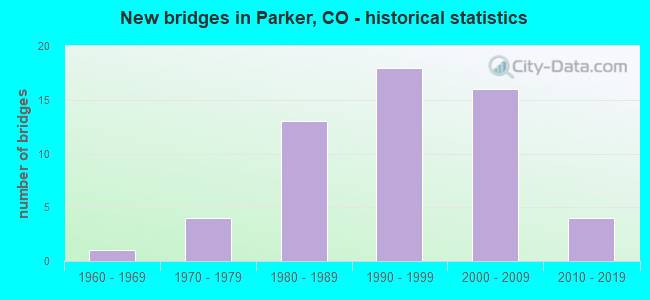
- New bridges - historical statistics
- 11960-1969
- 41970-1979
- 131980-1989
- 181990-1999
- 162000-2009
- 42010-2019

- Reconstructed bridges - Historical Statistics
- 31990-1999
- 02000-2009
- 52010-2019


- Bridge Condition - Deck
- 75.6%Good
- 22.0%Satisfactory
- 2.4%Fair

- Bridge Condition - Superstructure
- 14.6%Very good
- 65.9%Good
- 17.1%Satisfactory
- 2.4%Fair

- Bridge Condition - Substructure
- 9.8%Very good
- 75.6%Good
- 7.3%Satisfactory
- 7.3%Fair

- Bridge Condition - Channel
- 76.7%Very good
- 20.9%Good
- 2.3%Satisfactory

- Bridge Condition - Culverts
- 11.1%Good
- 88.9%Satisfactory
Find on map >> Show street view
Structure Number: DOUHESS-3.35, Location: 3.35M E. OF S. HAVANA ST. (Lat: 39.500325, Lng: -104.828311), Route carried "on" structure: County highway , Year Built: 2012, Status: Open, Structure Length: 3.06m (10.04ft), Average Daily Traffic: 9,535 (year 2021), Truck Traffic: 9%, Average Future Daily Traffic: 12,776 (year 2041), Design Load: HS 20, Features Intersected: ACCESS ROAD, Facility Carried by Structure: HESS ROAD
Minimum Vertical Clearance: 30.45m (99.90ft), Kilometerpoint: 4.635, Lanes on structure: 2, Lanes under structure: 2, Owner: County Highway Agency, Approaching Roadway Width: 9.1m (29.9ft), Material/Design: Prestressed concrete, Design/Construction: Stringer/Multi-beam, Number Of Spans In Main Unit: 1, Length of Maximum Span: 29.1m (95.5ft), Curb-To-Curb Width: 11.0m (36.1ft), Out-to-Out Width: 11.9m (39.0ft)
Condition: Deck: Good, Superstructure: Good, Substructure: Very good, Operating Rating: 73.0 metric tons, Method Used To Determine Operating Rating: Load and Resistance Factor (LRFR), Inventory Rating: 39.6 metric tons, Method Used To Determine Inventory Rating: Load and Resistance Factor (LRFR), Structural Evaluation: Better than present minimum criteria, Deck Geometry: Meets minimum limits, Underclear: Superior to present desirable criteria, Approach Roadway Alignment: Equal to present desirable criteria, Designated Inspection Frequency: Every 24 months, Inspection Date: Febuary 2021, Deck Structure Type: Concrete Cast-file-Place, Wearing Surface/Protective System: Wearing Surface: Bituminous, Membrane: Built-up, Deck Protection: Epoxy Coated Reinforcing
Find on map >> Show street view
Structure Number: DOUHESS-3.95, Location: 3.95M E. OF S. HAVANA ST. (Lat: 39.498656, Lng: -104.819150), Route carried "on" structure: County highway , Year Built: 2012, Status: Open, Structure Length: 2.16m (7.09ft), Average Daily Traffic: 7,987 (year 2021), Truck Traffic: 9%, Average Future Daily Traffic: 10,703 (year 2041), Design Load: HS 20, Features Intersected: NEWLIN GULCH, Facility Carried by Structure: HESS ROAD
Minimum Vertical Clearance: 30.45m (99.90ft), Kilometerpoint: 5.472, Lanes on structure: 2, Owner: County Highway Agency, Approaching Roadway Width: 9.1m (29.9ft), Material/Design: Prestressed concrete, Design/Construction: Stringer/Multi-beam, Number Of Spans In Main Unit: 1, Length of Maximum Span: 20.1m (65.9ft), Curb-To-Curb Width: 11.0m (36.1ft), Out-to-Out Width: 11.9m (39.0ft)
Condition: Deck: Good, Superstructure: Very good, Substructure: Very good, Channel: Very good, Operating Rating: 62.9 metric tons, Method Used To Determine Operating Rating: Load and Resistance Factor (LRFR), Inventory Rating: 45.2 metric tons, Method Used To Determine Inventory Rating: Load and Resistance Factor (LRFR), Structural Evaluation: Equal to present desirable criteria, Deck Geometry: Meets minimum limits, Waterway Adequacy: Equal to present desirable criteria, Approach Roadway Alignment: Equal to present desirable criteria, Designated Inspection Frequency: Every 24 months, Inspection Date: Febuary 2021, Deck Structure Type: Concrete Cast-file-Place, Wearing Surface/Protective System: Wearing Surface: Bituminous, Membrane: Built-up, Deck Protection: Epoxy Coated Reinforcing
Find on map >> Show street view
Structure Number: E-470-0.47A, Location: 0.47 MI FROM I 25 (Lat: 39.554083, Lng: -104.861889), Route carried "on" structure: Other road 470B, Year Built: 1990, Status: Open, Structure Length: 9.95m (32.64ft), Average Daily Traffic: 25,045 (year 2018), Truck Traffic: 6%, Average Future Daily Traffic: 42,580 (year 2038), Design Load: HS 20+Mod, Features Intersected: Cottonwood Ck & Jamaica, Facility Carried by Structure: E-470 EB
Minimum Vertical Clearance: 30+ m (98+ ft), Kilometerpoint: 0.751, Lanes on structure: 4, Lanes under structure: 5, Toll: On toll road, Owner: Local Toll Authority, Approaching Roadway Width: 20.7m (67.9ft), Skew: 1 degrees, Material/Design: Prestressed concrete continuous, Design/Construction: Box Beam or Girders - Multiple, Number Of Spans In Main Unit: 2, Length of Maximum Span: 49.3m (161.7ft), Curb-To-Curb Width: 20.7m (67.9ft), Out-to-Out Width: 21.3m (69.9ft)
Condition: Deck: Good, Superstructure: Good, Substructure: Good, Channel: Very good, Operating Rating: 56.2 metric tons, Method Used To Determine Operating Rating: Load Factor (LF), Inventory Rating: 33.6 metric tons, Method Used To Determine Inventory Rating: Load Factor (LF), Structural Evaluation: Better than present minimum criteria, Deck Geometry: Equal to present minimum criteria, Underclear: Equal to present minimum criteria, Waterway Adequacy: Superior to present desirable criteria, Approach Roadway Alignment: Equal to present desirable criteria, Designated Inspection Frequency: Every 24 months, Inspection Date: August 2020, Deck Structure Type: Concrete Cast-file-Place, Wearing Surface/Protective System: Wearing Surface: Bituminous, Deck Protection: Epoxy Coated Reinforcing
Find on map >> Show street view
Structure Number: E-470-05.13A, Location: 5.13 MI FROM I25 (Lat: 39.549750, Lng: -104.779806), Route carried "on" structure: Other road 470B, Year Built: 1996, Year Reconstructed: 2017, Status: Open, Structure Length: 18.53m (60.79ft), Average Daily Traffic: 24,407 (year 2018), Truck Traffic: 6%, Average Future Daily Traffic: 41,492 (year 2038), Design Load: HS 25 or greater, Features Intersected: Cherry Creek, Facility Carried by Structure: E-470 NB
Minimum Vertical Clearance: 30+ m (98+ ft), Kilometerpoint: 8.204, Lanes on structure: 3, Toll: On toll road, Owner: Local Toll Authority, Approaching Roadway Width: 21.9m (71.9ft), Material/Design: Prestressed concrete continuous, Design/Construction: Box Beam or Girders - Multiple, Number Of Spans In Main Unit: 4, Length of Maximum Span: 47.9m (157.2ft), Curb-To-Curb Width: 21.9m (71.9ft), Out-to-Out Width: 22.6m (74.1ft)
Condition: Deck: Good, Superstructure: Good, Substructure: Good, Channel: Very good, Operating Rating: 41.8 metric tons, Method Used To Determine Operating Rating: Load and Resistance Factor Rating (LRFR) rating reported by rating factor(RF) method using HL-93 loadings, Inventory Rating: 32.4 metric tons, Method Used To Determine Inventory Rating: Load and Resistance Factor Rating (LRFR) rating reported by rating factor(RF) method using HL-93 loadings, Structural Evaluation: Better than present minimum criteria, Deck Geometry: Superior to present desirable criteria, Waterway Adequacy: Equal to present desirable criteria, Approach Roadway Alignment: Equal to present desirable criteria, Designated Inspection Frequency: Every 24 months, Inspection Date: August 2020, Deck Structure Type: Other, Wearing Surface/Protective System: Wearing Surface: Bituminous, Membrane: Built-up, Deck Protection: Epoxy Coated Reinforcing
Find on map >> Show street view
Structure Number: E-470-05.25A, Location: 5.25 MI FROM I25 (Lat: 39.551806, Lng: -104.776194), Route carried "on" structure: Other road 470, Year Built: 1996, Year Reconstructed: 2016, Status: Open, Structure Length: 8.16m (26.77ft), Average Daily Traffic: 24,375 (year 2018), Truck Traffic: 6%, Average Future Daily Traffic: 41,438 (year 2038), Design Load: HS 25 or greater, Features Intersected: Parker Road
Minimum Vertical Clearance: 30+ m (98+ ft), Kilometerpoint: 8.590, Lanes on structure: 4, Lanes under structure: 8, Toll: On toll road, Owner: Local Toll Authority, Approaching Roadway Width: 24.4m (80.1ft), Skew: 1 degrees, Material/Design: Prestressed concrete continuous, Design/Construction: Stringer/Multi-beam, Number Of Spans In Main Unit: 2, Length of Maximum Span: 41.3m (135.5ft), Curb-To-Curb Width: 24.4m (80.1ft), Out-to-Out Width: 25.0m (82.0ft)
Condition: Deck: Good, Superstructure: Good, Substructure: Good, Operating Rating: 45.0 metric tons, Method Used To Determine Operating Rating: Load and Resistance Factor Rating (LRFR) rating reported by rating factor(RF) method using HL-93 loadings, Inventory Rating: 34.7 metric tons, Method Used To Determine Inventory Rating: Load and Resistance Factor Rating (LRFR) rating reported by rating factor(RF) method using HL-93 loadings, Structural Evaluation: Better than present minimum criteria, Deck Geometry: Superior to present desirable criteria, Underclear: Better than present minimum criteria, Approach Roadway Alignment: Equal to present desirable criteria, Designated Inspection Frequency: Every 24 months, Inspection Date: August 2020, Deck Structure Type: Concrete Cast-file-Place, Wearing Surface/Protective System: Wearing Surface: Bituminous, Membrane: Built-up, Deck Protection: Epoxy Coated Reinforcing
Find on map >> Show street view
Structure Number: E-470-05.25B, Location: 5.25 MI FROM I25 (Lat: 39.552250, Lng: -104.776417), Route carried "on" structure: Other road 470, Year Built: 1996, Year Reconstructed: 2016, Status: Open, Structure Length: 8.16m (26.77ft), Average Daily Traffic: 25,943 (year 2018), Truck Traffic: 6%, Average Future Daily Traffic: 44,103 (year 2038), Design Load: HS 25 or greater, Features Intersected: Parker Road
Minimum Vertical Clearance: 30+ m (98+ ft), Kilometerpoint: 8.605, Lanes on structure: 4, Lanes under structure: 8, Toll: On toll road, Owner: Local Toll Authority, Approaching Roadway Width: 24.4m (80.1ft), Skew: 1 degrees, Material/Design: Prestressed concrete continuous, Design/Construction: Stringer/Multi-beam, Number Of Spans In Main Unit: 2, Length of Maximum Span: 42.5m (139.4ft), Curb-To-Curb Width: 24.4m (80.1ft), Out-to-Out Width: 25.0m (82.0ft)
Condition: Deck: Good, Superstructure: Good, Substructure: Good, Operating Rating: 45.0 metric tons, Method Used To Determine Operating Rating: Load and Resistance Factor Rating (LRFR) rating reported by rating factor(RF) method using HL-93 loadings, Inventory Rating: 34.7 metric tons, Method Used To Determine Inventory Rating: Load and Resistance Factor Rating (LRFR) rating reported by rating factor(RF) method using HL-93 loadings, Structural Evaluation: Better than present minimum criteria, Deck Geometry: Superior to present desirable criteria, Underclear: Better than present minimum criteria, Approach Roadway Alignment: Equal to present desirable criteria, Designated Inspection Frequency: Every 24 months, Inspection Date: August 2020, Deck Structure Type: Concrete Cast-file-Place, Wearing Surface/Protective System: Wearing Surface: Bituminous, Membrane: Built-up, Deck Protection: Epoxy Coated Reinforcing
Find on map >> Show street view
Structure Number: E-470-05.76A, Location: 5.76 MI FROM I25 (Lat: 39.557583, Lng: -104.770972), Route carried "on" structure: Other road 470, Year Built: 1996, Year Reconstructed: 2017, Status: Open, Structure Length: 4.04m (13.25ft), Average Daily Traffic: 24,242 (year 2018), Truck Traffic: 6%, Average Future Daily Traffic: 43,105 (year 2038), Design Load: HS 25 or greater, Features Intersected: Cottonwood Drive
Minimum Vertical Clearance: 30+ m (98+ ft), Kilometerpoint: 9.400, Lanes on structure: 4, Lanes under structure: 4, Toll: On toll road, Owner: Local Toll Authority, Approaching Roadway Width: 21.9m (71.9ft), Skew: 1 degrees, Material/Design: Prestressed concrete, Design/Construction: Stringer/Multi-beam, Number Of Spans In Main Unit: 1, Length of Maximum Span: 38.8m (127.3ft), Curb-To-Curb Width: 25.5m (83.7ft), Out-to-Out Width: 26.2m (86.0ft)
Condition: Deck: Good, Superstructure: Very good, Substructure: Good, Operating Rating: 64.8 metric tons, Method Used To Determine Operating Rating: Load and Resistance Factor Rating (LRFR) rating reported by rating factor(RF) method using HL-93 loadings, Inventory Rating: 35.6 metric tons, Method Used To Determine Inventory Rating: Load and Resistance Factor Rating (LRFR) rating reported by rating factor(RF) method using HL-93 loadings, Structural Evaluation: Better than present minimum criteria, Deck Geometry: Superior to present desirable criteria, Underclear: Meets minimum limits, Approach Roadway Alignment: Equal to present desirable criteria, Designated Inspection Frequency: Every 24 months, Inspection Date: July 2020, Deck Structure Type: Concrete Cast-file-Place, Wearing Surface/Protective System: Wearing Surface: Bituminous, Membrane: Built-up, Deck Protection: Epoxy Coated Reinforcing
Find on map >> Show street view
Structure Number: E-470-05.76B, Location: 5.76 MI FROM I25 (Lat: 39.557639, Lng: -104.771250), Route carried "on" structure: Other road 470, Year Built: 1996, Year Reconstructed: 2017, Status: Open, Structure Length: 4.04m (13.25ft), Average Daily Traffic: 25,742 (year 2018), Truck Traffic: 6%, Average Future Daily Traffic: 45,820 (year 2038), Design Load: HS 25 or greater, Features Intersected: Cottonwood Drive
Minimum Vertical Clearance: 30+ m (98+ ft), Kilometerpoint: 9.402, Lanes on structure: 3, Lanes under structure: 4, Toll: On toll road, Owner: Local Toll Authority, Approaching Roadway Width: 21.9m (71.9ft), Skew: 1 degrees, Material/Design: Prestressed concrete, Design/Construction: Stringer/Multi-beam, Number Of Spans In Main Unit: 1, Length of Maximum Span: 38.8m (127.3ft), Curb-To-Curb Width: 21.9m (71.9ft), Out-to-Out Width: 22.6m (74.1ft)
Condition: Deck: Good, Superstructure: Good, Substructure: Good, Operating Rating: 64.8 metric tons, Method Used To Determine Operating Rating: Load and Resistance Factor Rating (LRFR) rating reported by rating factor(RF) method using HL-93 loadings, Inventory Rating: 35.6 metric tons, Method Used To Determine Inventory Rating: Load and Resistance Factor Rating (LRFR) rating reported by rating factor(RF) method using HL-93 loadings, Structural Evaluation: Better than present minimum criteria, Deck Geometry: Superior to present desirable criteria, Underclear: Meets minimum limits, Approach Roadway Alignment: Equal to present desirable criteria, Designated Inspection Frequency: Every 24 months, Inspection Date: July 2020, Deck Structure Type: Concrete Cast-file-Place, Wearing Surface/Protective System: Wearing Surface: Bituminous, Membrane: Built-up, Deck Protection: Epoxy Coated Reinforcing
Find on map >> Show street view
Structure Number: E-470-4.33A, Location: 4.33 MI FROM I 25 (Lat: 39.548917, Lng: -104.793417), Route carried "on" structure: Other road 470B, Year Built: 1989, Year Reconstructed: 2004, Status: Open, Structure Length: 4.88m (16.01ft), Average Daily Traffic: 24,616 (year 2018), Truck Traffic: 6%, Average Future Daily Traffic: 41,847 (year 2038), Design Load: HS 20+Mod, Features Intersected: Jordan Road, Facility Carried by Structure: E-470 EB
Minimum Vertical Clearance: 30+ m (98+ ft), Kilometerpoint: 6.999, Lanes on structure: 3, Lanes under structure: 4, Toll: On toll road, Owner: Local Toll Authority, Approaching Roadway Width: 21.3m (69.9ft), Material/Design: Steel, Design/Construction: Stringer/Multi-beam, Number Of Spans In Main Unit: 1, Length of Maximum Span: 48.2m (158.1ft), Curb-To-Curb Width: 21.3m (69.9ft), Out-to-Out Width: 21.9m (71.9ft)
Condition: Deck: Good, Superstructure: Good, Substructure: Good, Operating Rating: 49.4 metric tons, Method Used To Determine Operating Rating: Load and Resistance Factor (LRFR), Inventory Rating: 38.1 metric tons, Method Used To Determine Inventory Rating: Load and Resistance Factor (LRFR), Structural Evaluation: Better than present minimum criteria, Deck Geometry: Superior to present desirable criteria, Underclear: Superior to present desirable criteria, Approach Roadway Alignment: Equal to present desirable criteria, Designated Inspection Frequency: Every 24 months, Inspection Date: August 2020, Deck Structure Type: Concrete Cast-file-Place, Wearing Surface/Protective System: Wearing Surface: Bituminous, Deck Protection: Epoxy Coated Reinforcing
Find on map >> Show street view
Structure Number: E-470-4.33B, Location: 4.33 MI FROM I 25 (Lat: 39.549278, Lng: -104.793444), Route carried "on" structure: Other road 470B, Year Built: 1989, Year Reconstructed: 2004, Status: Open, Structure Length: 4.88m (16.01ft), Average Daily Traffic: 26,306 (year 2018), Truck Traffic: 6%, Average Future Daily Traffic: 28,700 (year 2038), Design Load: HS 20+Mod, Features Intersected: Jordan Road, Facility Carried by Structure: E-470 WB
Minimum Vertical Clearance: 30+ m (98+ ft), Kilometerpoint: 6.994, Lanes on structure: 3, Lanes under structure: 5, Toll: On toll road, Owner: Local Toll Authority, Approaching Roadway Width: 21.3m (69.9ft), Material/Design: Steel, Design/Construction: Stringer/Multi-beam, Number Of Spans In Main Unit: 1, Length of Maximum Span: 47.5m (155.8ft), Curb-To-Curb Width: 21.3m (69.9ft), Out-to-Out Width: 22.6m (74.1ft)
Condition: Deck: Good, Superstructure: Good, Substructure: Good, Operating Rating: 36.3 metric tons, Method Used To Determine Operating Rating: Field evaluation and documented engineering judgment, Inventory Rating: 32.7 metric tons, Method Used To Determine Inventory Rating: Field evaluation and documented engineering judgment, Structural Evaluation: Better than present minimum criteria, Deck Geometry: Superior to present desirable criteria, Underclear: Superior to present desirable criteria, Approach Roadway Alignment: Better than present minimum criteria, Designated Inspection Frequency: Every 24 months, Inspection Date: August 2020, Deck Structure Type: Concrete Cast-file-Place, Wearing Surface/Protective System: Wearing Surface: Bituminous, Deck Protection: Epoxy Coated Reinforcing
Find on map >> Show street view
Structure Number: E-470-5.13B, Location: 5.13 MI FROM I 25 (Lat: 39.550222, Lng: -104.780056), Route carried "on" structure: Other road 470, Year Built: 1990, Status: Open, Structure Length: 18.53m (60.79ft), Average Daily Traffic: 25,990 (year 2018), Truck Traffic: 6%, Average Future Daily Traffic: 44,183 (year 2038), Design Load: HS 20+Mod, Features Intersected: Cherry Creek
Minimum Vertical Clearance: 30+ m (98+ ft), Kilometerpoint: 8.213, Lanes on structure: 4, Toll: On toll road, Owner: Local Toll Authority, Approaching Roadway Width: 24.4m (80.1ft), Skew: 30 degrees, Material/Design: Prestressed concrete continuous, Design/Construction: Box Beam or Girders - Single/Spread, Number Of Spans In Main Unit: 4, Length of Maximum Span: 48.8m (160.1ft), Curb-To-Curb Width: 24.4m (80.1ft), Out-to-Out Width: 25.0m (82.0ft)
Condition: Deck: Good, Superstructure: Good, Substructure: Good, Channel: Very good, Operating Rating: 66.2 metric tons, Method Used To Determine Operating Rating: Load Factor (LF), Inventory Rating: 41.7 metric tons, Method Used To Determine Inventory Rating: Load Factor (LF), Structural Evaluation: Better than present minimum criteria, Deck Geometry: Superior to present desirable criteria, Waterway Adequacy: Equal to present desirable criteria, Approach Roadway Alignment: Equal to present desirable criteria, Designated Inspection Frequency: Every 24 months, Inspection Date: August 2020, Deck Structure Type: Other, Wearing Surface/Protective System: Wearing Surface: Bituminous, Deck Protection: Epoxy Coated Reinforcing
Find on map >> Show street view
Structure Number: E-470-5.13D, Location: 5.13 MI FROM I 25 (Lat: 39.549361, Lng: -104.779750), Route carried "on" structure: Other road 47000, Year Built: 1990, Status: Open, Structure Length: 19.57m (64.21ft), Average Daily Traffic: 8,200 (year 2018), Truck Traffic: 1%, Average Future Daily Traffic: 4,080 (year 2021), Design Load: HS 20+Mod, Features Intersected: Cherry Creek, Facility Carried by Structure: Ramp A
Minimum Vertical Clearance: 30+ m (98+ ft), Kilometerpoint: 0.288, Lanes on structure: 2, Toll: On toll road, Owner: Local Toll Authority, Approaching Roadway Width: 11.6m (38.1ft), Skew: 1 degrees, Material/Design: Prestressed concrete continuous, Design/Construction: Box Beam or Girders - Single/Spread, Number Of Spans In Main Unit: 4, Length of Maximum Span: 50.8m (166.7ft), Curb-To-Curb Width: 11.6m (38.1ft), Out-to-Out Width: 12.2m (40.0ft)
Condition: Deck: Good, Superstructure: Good, Substructure: Good, Channel: Very good, Operating Rating: 66.2 metric tons, Method Used To Determine Operating Rating: Load Factor (LF), Inventory Rating: 41.7 metric tons, Method Used To Determine Inventory Rating: Load Factor (LF), Structural Evaluation: Better than present minimum criteria, Deck Geometry: Equal to present minimum criteria, Waterway Adequacy: Equal to present desirable criteria, Approach Roadway Alignment: Equal to present desirable criteria, Designated Inspection Frequency: Every 24 months, Inspection Date: August 2020, Deck Structure Type: Other, Wearing Surface/Protective System: Wearing Surface: Gravel, Deck Protection: Epoxy Coated Reinforcing
Find on map >> Show street view
Structure Number: F-17-HI, Location: 8.1 MI N OF JCT SH 86 (Lat: 39.514944, Lng: -104.764308), Route carried "on" structure: State highway 83A, Year Built: 1981, Status: Open, Structure Length: 5.64m (18.50ft), Average Daily Traffic: 44,000 (year 2020), Truck Traffic: 4%, Average Future Daily Traffic: 53,680 (year 2040), Design Load: HS 20, Features Intersected: SULPHUR GULCH, Facility Carried by Structure: SH 83 ML
Minimum Vertical Clearance: 30+ m (98+ ft), Kilometerpoint: 62.731, Lanes on structure: 6, Base Highway Network: Yes, Owner: State Highway Agency, Approaching Roadway Width: 24.4m (80.1ft), Skew: 21 degrees, Material/Design: Prestressed concrete continuous, Design/Construction: Tee Beam, Number Of Spans In Main Unit: 2, Length of Maximum Span: 27.7m (90.9ft), Curb-To-Curb Width: 25.6m (84.0ft), Out-to-Out Width: 26.4m (86.6ft)
Condition: Deck: Good, Superstructure: Very good, Substructure: Good, Channel: Very good, Operating Rating: 49.0 metric tons, Method Used To Determine Operating Rating: Load Factor (LF), Inventory Rating: 15.7 metric tons, Method Used To Determine Inventory Rating: Load Factor (LF), Structural Evaluation: High priority of corrective action, Deck Geometry: Somewhat better than minimum adequacy, Waterway Adequacy: Equal to present minimum criteria, Approach Roadway Alignment: Equal to present desirable criteria, Designated Inspection Frequency: Every 24 months, Inspection Date: June 2021, Deck Structure Type: Concrete Cast-file-Place, Wearing Surface/Protective System: Wearing Surface: Bituminous, Membrane: Preformed Fabric
Find on map >> Show street view
Structure Number: F-17-IB, Location: 10 MI N OF JCT SH 86 (Lat: 39.540189, Lng: -104.769442), Route carried "on" structure: State highway 83A, Year Built: 1982, Status: Open, Structure Length: 0.91m (2.99ft), Average Daily Traffic: 50,000 (year 2020), Truck Traffic: 4%, Average Future Daily Traffic: 63,000 (year 2040), Design Load: HS 20, Features Intersected: BALDWIN GULCH, Facility Carried by Structure: SH 83 ML
Minimum Vertical Clearance: 30+ m (98+ ft), Kilometerpoint: 65.574, Lanes on structure: 8, Base Highway Network: Yes, Owner: State Highway Agency, Approaching Roadway Width: 32.6m (107.0ft), Skew: 4 degrees, Material/Design: Concrete, Design/Construction: Culvert, Number Of Spans In Main Unit: 2, Length of Maximum Span: 4.3m (14.1ft), Out-to-Out Width: 73.7m (241.8ft)
Condition: Channel: Very good, Culverts: Satisfactory, Operating Rating: 36.3 metric tons, Method Used To Determine Operating Rating: Field evaluation and documented engineering judgment, Inventory Rating: 32.7 metric tons, Method Used To Determine Inventory Rating: Field evaluation and documented engineering judgment, Structural Evaluation: Equal to present minimum criteria, Waterway Adequacy: Better than present minimum criteria, Approach Roadway Alignment: Equal to present desirable criteria, Designated Inspection Frequency: Every 48 months, Inspection Date: April 2019
Find on map >> Show street view
Structure Number: G-17-BO, Location: 6.3 MI N OF JCT SH86 (Lat: 39.479908, Lng: -104.757792), Route carried "on" structure: State highway 83A, Year Built: 1962, Year Reconstructed: 1998, Status: Open, Structure Length: 0.71m (2.33ft), Average Daily Traffic: 36,000 (year 2020), Truck Traffic: 4%, Average Future Daily Traffic: 45,360 (year 2040), Design Load: HS 20, Features Intersected: UNNAMED DRAINAGE, Facility Carried by Structure: SH83 ML
Minimum Vertical Clearance: 30+ m (98+ ft), Kilometerpoint: 58.801, Lanes on structure: 8, Base Highway Network: Yes, Owner: State Highway Agency, Approaching Roadway Width: 32.9m (107.9ft), Skew: 13 degrees, Material/Design: Concrete, Design/Construction: Culvert, Number Of Spans In Main Unit: 1, Length of Maximum Span: 7.1m (23.3ft), Out-to-Out Width: 116.7m (382.9ft)
Condition: Channel: Good, Culverts: Satisfactory, Operating Rating: 89.8 metric tons, Method Used To Determine Operating Rating: Field evaluation and documented engineering judgment, Inventory Rating: 89.8 metric tons, Method Used To Determine Inventory Rating: Field evaluation and documented engineering judgment, Structural Evaluation: Equal to present minimum criteria, Waterway Adequacy: Equal to present desirable criteria, Approach Roadway Alignment: Equal to present desirable criteria, Designated Inspection Frequency: Every 24 months, Inspection Date: June 2021
Find on map >> Show street view
Structure Number: PAR CANTBRY-0.2, Location: .2 MI N. OF HILLTOP ROAD (Lat: 39.492947, Lng: -104.733528), Route carried "on" structure: City street , Year Built: 2003, Status: Open, Structure Length: 0.64m (2.10ft), Average Daily Traffic: 6,121 (year 2021), Truck Traffic: 2%, Average Future Daily Traffic: 8,203 (year 2041), Design Load: HS 20, Features Intersected: TALLMAN GULCH, Facility Carried by Structure: CANTERBERRY PKWY
Minimum Vertical Clearance: 30+ m (98+ ft), Kilometerpoint: 4.138, Lanes on structure: 3, Owner: Town or Township Highway Agency, Approaching Roadway Width: 14.3m (46.9ft), Skew: 30 degrees, Material/Design: Concrete, Design/Construction: Culvert, Number Of Spans In Main Unit: 2, Length of Maximum Span: 3.0m (9.8ft), Curb or Sidewalk Widths: Left: 3.0m (9.8ft), Right: 1.5m (4.9ft), Out-to-Out Width: 42.9m (140.7ft)
Condition: Channel: Very good, Culverts: Satisfactory, Operating Rating: 61.0 metric tons, Method Used To Determine Operating Rating: Load Factor (LF), Inventory Rating: 36.5 metric tons, Method Used To Determine Inventory Rating: Load Factor (LF), Structural Evaluation: Equal to present minimum criteria, Waterway Adequacy: Equal to present desirable criteria, Approach Roadway Alignment: Equal to present desirable criteria, Designated Inspection Frequency: Every 24 months, Inspection Date: Febuary 2021
Find on map >> Show street view
Structure Number: PAR CANTBRY-0.3, Location: 0.3 MI S OF MAIN STREET (Lat: 39.513792, Lng: -104.724922), Route carried "on" structure: City street , Year Built: 1998, Status: Open, Structure Length: 3.16m (10.37ft), Average Daily Traffic: 6,259 (year 2021), Truck Traffic: 4%, Average Future Daily Traffic: 8,387 (year 2041), Design Load: HS 20, Features Intersected: SULPHUR GULCH, Facility Carried by Structure: CANTERBERRY PKWAY
Minimum Vertical Clearance: 30+ m (98+ ft), Kilometerpoint: 0.531, Lanes on structure: 4, Owner: Town or Township Highway Agency, Approaching Roadway Width: 16.5m (54.1ft), Skew: 30 degrees, Material/Design: Concrete, Design/Construction: Frame, Number Of Spans In Main Unit: 4, Length of Maximum Span: 7.3m (24.0ft), Curb or Sidewalk Widths: Left: 2.9m (9.5ft), Right: 3.0m (9.8ft), Curb-To-Curb Width: 16.3m (53.5ft), Out-to-Out Width: 27.0m (88.6ft)
Condition: Deck: Good, Superstructure: Good, Substructure: Satisfactory, Channel: Good, Operating Rating: 36.3 metric tons, Method Used To Determine Operating Rating: Field evaluation and documented engineering judgment, Inventory Rating: 32.7 metric tons, Method Used To Determine Inventory Rating: Field evaluation and documented engineering judgment, Structural Evaluation: Equal to present minimum criteria, Deck Geometry: Meets minimum limits, Waterway Adequacy: Equal to present desirable criteria, Approach Roadway Alignment: Equal to present desirable criteria, Length Of Structure Improvement: 3.16m (10.37ft), Designated Inspection Frequency: Every 24 months, Inspection Date: Febuary 2021, Bridge Improvement Cost: $409,000, Roadway Improvement Cost: $41,000, Total Project Cost: $450,000 ( Estimate for 2015)
Find on map >> Show street view
Structure Number: PAR CANTTRL-0.1, Location: 0.1 MI S OF GLENMOOR DR (Lat: 39.511378, Lng: -104.711717), Route carried "on" structure: City street , Year Built: 1998, Status: Open, Structure Length: 0.91m (2.99ft), Average Daily Traffic: 2,280 (year 2021), Truck Traffic: 2%, Average Future Daily Traffic: 3,055 (year 2041), Design Load: HS 20, Features Intersected: SULPHUR GULCH, Facility Carried by Structure: CANTERBERRY TRAIL
Minimum Vertical Clearance: 30+ m (98+ ft), Kilometerpoint: 1.250, Lanes on structure: 2, Owner: Town or Township Highway Agency, Approaching Roadway Width: 14.6m (47.9ft), Material/Design: Concrete, Design/Construction: Culvert, Number Of Spans In Main Unit: 2, Length of Maximum Span: 4.2m (13.8ft), Curb or Sidewalk Widths: Left: 1.8m (5.9ft), Right: 2.7m (8.9ft), Out-to-Out Width: 33.0m (108.3ft)
Condition: Channel: Good, Culverts: Satisfactory, Operating Rating: 36.3 metric tons, Method Used To Determine Operating Rating: Field evaluation and documented engineering judgment, Inventory Rating: 32.7 metric tons, Method Used To Determine Inventory Rating: Field evaluation and documented engineering judgment, Structural Evaluation: Equal to present minimum criteria, Waterway Adequacy: Equal to present desirable criteria, Approach Roadway Alignment: Equal to present desirable criteria, Designated Inspection Frequency: Every 24 months, Inspection Date: Febuary 2021
Find on map >> Show street view
Structure Number: PAR CHAMBR-0.15, Location: .2 MI SE OF COMPARK BLVD (Lat: 39.560681, Lng: -104.808547), Route carried "on" structure: City street , Year Built: 2002, Status: Open, Structure Length: 3.31m (10.86ft), Average Daily Traffic: 13,246 (year 2021), Truck Traffic: 4%, Average Future Daily Traffic: 17,749 (year 2041), Design Load: HS 20, Features Intersected: HAPPY CANYON CREEK, Facility Carried by Structure: CHAMBERS ROAD
Minimum Vertical Clearance: 30+ m (98+ ft), Kilometerpoint: 2.805, Lanes on structure: 4, Owner: Town or Township Highway Agency, Approaching Roadway Width: 16.3m (53.5ft), Skew: 31 degrees, Material/Design: Prestressed concrete, Design/Construction: Stringer/Multi-beam, Number Of Spans In Main Unit: 1, Length of Maximum Span: 30.5m (100.1ft), Curb or Sidewalk Widths: Left: 2.2m (7.2ft), Right: 3.1m (10.2ft), Curb-To-Curb Width: 16.5m (54.1ft), Out-to-Out Width: 24.5m (80.4ft)
Condition: Deck: Satisfactory, Superstructure: Satisfactory, Substructure: Good, Channel: Very good, Operating Rating: 72.3 metric tons, Method Used To Determine Operating Rating: Load Factor (LF), Inventory Rating: 43.5 metric tons, Method Used To Determine Inventory Rating: Load Factor (LF), Structural Evaluation: Equal to present minimum criteria, Deck Geometry: Meets minimum limits, Waterway Adequacy: Equal to present desirable criteria, Approach Roadway Alignment: Equal to present desirable criteria, Designated Inspection Frequency: Every 24 months, Inspection Date: Febuary 2021, Deck Structure Type: Concrete Cast-file-Place, Wearing Surface/Protective System: Wearing Surface: Monolithic Concrete, Deck Protection: Epoxy Coated Reinforcing
Find on map >> Show street view
Structure Number: PAR CHAMBR-4., Location: .4 M NW NEWLIN GULCH BLVD (Lat: 39.504994, Lng: -104.813719), Route carried "on" structure: City street , Year Built: 2009, Status: Open, Structure Length: 4.31m (14.14ft), Average Daily Traffic: 13,454 (year 2021), Truck Traffic: 2%, Average Future Daily Traffic: 18,028 (year 2041), Features Intersected: NEWLIN GULCH, Facility Carried by Structure: CHAMBERS RD SB
Minimum Vertical Clearance: 30+ m (98+ ft), Kilometerpoint: 1.739, Lanes on structure: 3, Owner: Town or Township Highway Agency, Approaching Roadway Width: 14.0m (45.9ft), Skew: 2 degrees, Material/Design: Prestressed concrete, Design/Construction: Stringer/Multi-beam, Number Of Spans In Main Unit: 1, Length of Maximum Span: 41.1m (134.8ft), Curb or Sidewalk Widths: Left: 2.6m (8.5ft), Right: 0.0m, Curb-To-Curb Width: 14.0m (45.9ft), Out-to-Out Width: 17.5m (57.4ft)
Condition: Deck: Good, Superstructure: Very good, Substructure: Good, Channel: Very good, Operating Rating: 58.1 metric tons, Method Used To Determine Operating Rating: Load and Resistance Factor (LRFR), Inventory Rating: 34.5 metric tons, Method Used To Determine Inventory Rating: Load and Resistance Factor (LRFR), Structural Evaluation: Better than present minimum criteria, Deck Geometry: Somewhat better than minimum adequacy, Waterway Adequacy: Equal to present desirable criteria, Approach Roadway Alignment: Equal to present desirable criteria, Length Of Structure Improvement: 4.31m (14.14ft), Designated Inspection Frequency: Every 24 months, Inspection Date: Febuary 2021, Deck Structure Type: Concrete Cast-file-Place, Wearing Surface/Protective System: Wearing Surface: Bituminous, Membrane: Preformed Fabric, Deck Protection: Epoxy Coated Reinforcing
Find on map >> Show street view
Structure Number: PAR CHMBR-4.0NB, Location: 1.1 MI N of HESS ROAD (Lat: 39.504828, Lng: -104.813464), Route carried "on" structure: City street , Year Built: 2017, Status: Open, Structure Length: 4.34m (14.24ft), Average Daily Traffic: 8,373 (year 2022), Truck Traffic: 2%, Average Future Daily Traffic: 11,220 (year 2042), Design Load: HL 93, Features Intersected: NEWLIN GULCH, Facility Carried by Structure: CHAMBERS RD NB
Minimum Vertical Clearance: 30+ m (98+ ft), Kilometerpoint: 1.712, Lanes on structure: 3, Owner: Town or Township Highway Agency, Approaching Roadway Width: 14.0m (45.9ft), Skew: 2 degrees, Material/Design: Prestressed concrete, Design/Construction: Stringer/Multi-beam, Number Of Spans In Main Unit: 1, Length of Maximum Span: 42.4m (139.1ft), Curb or Sidewalk Widths: Left: 0.0m, Right: 2.7m (8.9ft), Curb-To-Curb Width: 17.7m (58.1ft), Out-to-Out Width: 21.3m (69.9ft)
Condition: Deck: Good, Superstructure: Very good, Substructure: Good, Channel: Very good, Operating Rating: 58.3 metric tons, Method Used To Determine Operating Rating: Load and Resistance Factor Rating (LRFR) rating reported by rating factor(RF) method using HL-93 loadings, Inventory Rating: 29.5 metric tons, Method Used To Determine Inventory Rating: Load and Resistance Factor Rating (LRFR) rating reported by rating factor(RF) method using HL-93 loadings, Structural Evaluation: Better than present minimum criteria, Deck Geometry: Superior to present desirable criteria, Waterway Adequacy: Equal to present desirable criteria, Approach Roadway Alignment: Equal to present desirable criteria, Designated Inspection Frequency: Every 24 months, Inspection Date: Febuary 2021, Deck Structure Type: Concrete Precast Panels, Wearing Surface/Protective System: Wearing Surface: Bituminous, Membrane: Preformed Fabric, Deck Protection: Epoxy Coated Reinforcing
Find on map >> Show street view
Structure Number: PAR CROWFT-0.6, Location: 0.6 MI S OF STROH ROAD (Lat: 39.471619, Lng: -104.781506), Route carried "on" structure: City street , Year Built: 2002, Status: Open, Structure Length: 3.47m (11.38ft), Average Daily Traffic: 5,095 (year 2021), Truck Traffic: 9%, Average Future Daily Traffic: 6,827 (year 2041), Design Load: HS 25 or greater, Features Intersected: LEMON GULCH, Facility Carried by Structure: CROWFOOT VALLEY RD
Minimum Vertical Clearance: 30+ m (98+ ft), Kilometerpoint: 2.061, Lanes on structure: 3, Owner: Town or Township Highway Agency, Approaching Roadway Width: 10.9m (35.8ft), Skew: 4 degrees, Material/Design: Prestressed concrete, Design/Construction: Stringer/Multi-beam, Number Of Spans In Main Unit: 1, Length of Maximum Span: 31.3m (102.7ft), Curb-To-Curb Width: 18.3m (60.0ft), Out-to-Out Width: 19.2m (63.0ft)
Condition: Deck: Good, Superstructure: Good, Substructure: Good, Channel: Very good, Operating Rating: 81.6 metric tons, Method Used To Determine Operating Rating: Load Factor (LF), Inventory Rating: 56.7 metric tons, Method Used To Determine Inventory Rating: Load Factor (LF), Structural Evaluation: Better than present minimum criteria, Deck Geometry: Superior to present desirable criteria, Waterway Adequacy: Equal to present desirable criteria, Approach Roadway Alignment: Equal to present desirable criteria, Designated Inspection Frequency: Every 24 months, Inspection Date: Febuary 2021, Deck Structure Type: Concrete Cast-file-Place, Wearing Surface/Protective System: Wearing Surface: Epoxy Overlay, Deck Protection: Epoxy Coated Reinforcing
Find on map >> Show street view
Structure Number: PAR CTNWD-0.5, Location: .5 M WEST OF PARKER RD (Lat: 39.556394, Lng: -104.786125), Route carried "on" structure: City street , Year Built: 1988, Status: Open, Structure Length: 19.05m (62.50ft), Average Daily Traffic: 12,733 (year 2021), Truck Traffic: 4%, Average Future Daily Traffic: 17,062 (year 2041), Design Load: HS 20, Features Intersected: CHERRY CREEK, Facility Carried by Structure: COTTONWOOD DR
Minimum Vertical Clearance: 30+ m (98+ ft), Kilometerpoint: 1.305, Lanes on structure: 2, Owner: Town or Township Highway Agency, Approaching Roadway Width: 8.5m (27.9ft), Material/Design: Prestressed concrete continuous, Design/Construction: Stringer/Multi-beam, Number Of Spans In Main Unit: 5, Length of Maximum Span: 36.9m (121.1ft), Curb or Sidewalk Widths: Left: 2.5m (8.2ft), Right: 0.0m, Curb-To-Curb Width: 8.5m (27.9ft), Out-to-Out Width: 12.5m (41.0ft)
Condition: Deck: Good, Superstructure: Very good, Substructure: Good, Channel: Good, Operating Rating: 62.4 metric tons, Method Used To Determine Operating Rating: Load Factor (LF), Inventory Rating: 37.5 metric tons, Method Used To Determine Inventory Rating: Load Factor (LF), Structural Evaluation: Better than present minimum criteria, Deck Geometry: Meets minimum limits, Waterway Adequacy: Equal to present desirable criteria, Approach Roadway Alignment: Equal to present desirable criteria, Designated Inspection Frequency: Every 24 months, Inspection Date: Febuary 2021, Deck Structure Type: Concrete Cast-file-Place, Wearing Surface/Protective System: Wearing Surface: Bituminous, Membrane: Built-up, Deck Protection: Epoxy Coated Reinforcing
Find on map >> Show street view
Structure Number: PAR DRNFLDT-0.2, Location: .2 MI S OF MAIN STREET (Lat: 39.515008, Lng: -104.770003), Route carried "on" structure: City street , Year Built: 2000, Status: Open, Structure Length: 5.62m (18.44ft), Average Daily Traffic: 8,479 (year 2021), Truck Traffic: 4%, Average Future Daily Traffic: 11,362 (year 2041), Design Load: HS 25 or greater, Features Intersected: SULPHUR GULCH, Facility Carried by Structure: DRANSFELDT ROAD
Minimum Vertical Clearance: 30+ m (98+ ft), Kilometerpoint: 0.471, Lanes on structure: 4, Owner: Town or Township Highway Agency, Approaching Roadway Width: 19.5m (64.0ft), Skew: 2 degrees, Material/Design: Prestressed concrete continuous, Design/Construction: Stringer/Multi-beam, Number Of Spans In Main Unit: 2, Length of Maximum Span: 26.8m (87.9ft), Curb or Sidewalk Widths: Left: 2.6m (8.5ft), Right: 2.6m (8.5ft), Curb-To-Curb Width: 20.7m (67.9ft), Out-to-Out Width: 26.8m (87.9ft)
Condition: Deck: Satisfactory, Superstructure: Good, Substructure: Good, Channel: Very good, Operating Rating: 82.6 metric tons, Method Used To Determine Operating Rating: Load Factor (LF), Inventory Rating: 45.1 metric tons, Method Used To Determine Inventory Rating: Load Factor (LF), Structural Evaluation: Better than present minimum criteria, Deck Geometry: Superior to present desirable criteria, Waterway Adequacy: Equal to present desirable criteria, Approach Roadway Alignment: Equal to present desirable criteria, Designated Inspection Frequency: Every 24 months, Inspection Date: Febuary 2021, Deck Structure Type: Concrete Cast-file-Place, Wearing Surface/Protective System: Wearing Surface: Bituminous, Membrane: Built-up, Deck Protection: Epoxy Coated Reinforcing
Find on map >> Show street view
Structure Number: PAR HESS-0.25, Location: 0.5 MI W OF PARKER RD (Lat: 39.493117, Lng: -104.769008), Route carried "on" structure: City street , Year Built: 2008, Status: Open, Structure Length: 18.75m (61.52ft), Average Daily Traffic: 10,120 (year 2021), Truck Traffic: 9%, Average Future Daily Traffic: 13,560 (year 2041), Design Load: HS 25 or greater, Features Intersected: CHERRY CREEK, Facility Carried by Structure: HESS ROAD WB
Minimum Vertical Clearance: 30+ m (98+ ft), Kilometerpoint: 3.750, Lanes on structure: 2, Owner: Town or Township Highway Agency, Approaching Roadway Width: 8.2m (26.9ft), Skew: 10 degrees, Material/Design: Prestressed concrete continuous, Design/Construction: Box Beam or Girders - Single/Spread, Number Of Spans In Main Unit: 5, Length of Maximum Span: 38.1m (125.0ft), Curb or Sidewalk Widths: Left: 3.2m (10.5ft), Right: 0.0m, Curb-To-Curb Width: 8.2m (26.9ft), Out-to-Out Width: 12.3m (40.4ft)
Condition: Deck: Good, Superstructure: Good, Substructure: Very good, Channel: Very good, Operating Rating: 36.3 metric tons, Method Used To Determine Operating Rating: Field evaluation and documented engineering judgment, Inventory Rating: 32.7 metric tons, Method Used To Determine Inventory Rating: Field evaluation and documented engineering judgment, Structural Evaluation: Better than present minimum criteria, Deck Geometry: High priority of corrective action, Waterway Adequacy: Equal to present desirable criteria, Approach Roadway Alignment: Equal to present desirable criteria, Designated Inspection Frequency: Every 24 months, Inspection Date: Febuary 2021, Deck Structure Type: Concrete Precast Panels, Wearing Surface/Protective System: Wearing Surface: Bituminous, Membrane: Built-up, Deck Protection: Epoxy Coated Reinforcing
Find on map >> Show street view
Structure Number: PAR HESS-0.25EB, Location: .5 MI W. OF PARKER RD. (Lat: 39.493056, Lng: -104.769722), Route carried "on" structure: City street , Year Built: 2014, Status: Open, Structure Length: 18.75m (61.52ft), Average Daily Traffic: 11,038 (year 2021), Truck Traffic: 9%, Average Future Daily Traffic: 14,791 (year 2041), Features Intersected: CHERRY CREEK, Facility Carried by Structure: HESS ROAD EB
Minimum Vertical Clearance: 30+ m (98+ ft), Kilometerpoint: 3.689, Lanes on structure: 2, Owner: Town or Township Highway Agency, Approaching Roadway Width: 8.2m (26.9ft), Skew: 10 degrees, Material/Design: Prestressed concrete continuous, Design/Construction: Box Beam or Girders - Single/Spread, Number Of Spans In Main Unit: 5, Length of Maximum Span: 38.1m (125.0ft), Curb or Sidewalk Widths: Left: 0.0m, Right: 3.2m (10.5ft), Curb-To-Curb Width: 8.2m (26.9ft), Out-to-Out Width: 12.3m (40.4ft)
Condition: Deck: Good, Superstructure: Good, Substructure: Good, Channel: Very good, Operating Rating: 36.3 metric tons, Method Used To Determine Operating Rating: Field evaluation and documented engineering judgment, Inventory Rating: 32.7 metric tons, Method Used To Determine Inventory Rating: Field evaluation and documented engineering judgment, Structural Evaluation: Better than present minimum criteria, Deck Geometry: High priority of corrective action, Waterway Adequacy: Equal to present desirable criteria, Approach Roadway Alignment: Equal to present desirable criteria, Designated Inspection Frequency: Every 24 months, Inspection Date: Febuary 2021, Deck Structure Type: Concrete Precast Panels, Wearing Surface/Protective System: Wearing Surface: Bituminous, Membrane: Built-up, Deck Protection: Epoxy Coated Reinforcing
Find on map >> Show street view
Structure Number: PAR JMORGAN-0.5, Location: .5 M WEST OF PARKER RD (Lat: 39.484633, Lng: -104.765839), Route carried "on" structure: City street , Year Built: 1988, Status: Open, Structure Length: 0.64m (2.10ft), Average Daily Traffic: 857 (year 2021), Truck Traffic: 4%, Average Future Daily Traffic: 1,148 (year 2041), Features Intersected: BRANCH OF CHERRY CREEK, Facility Carried by Structure: J MORGAN BLVD
Minimum Vertical Clearance: 30+ m (98+ ft), Kilometerpoint: 0.830, Lanes on structure: 2, Owner: Town or Township Highway Agency, Approaching Roadway Width: 13.4m (44.0ft), Material/Design: Concrete, Design/Construction: Culvert, Number Of Spans In Main Unit: 2, Length of Maximum Span: 3.0m (9.8ft), Curb or Sidewalk Widths: Left: 2.0m (6.6ft), Right: 0.0m, Out-to-Out Width: 30.8m (101.0ft)
Condition: Channel: Good, Culverts: Satisfactory, Operating Rating: 42.3 metric tons, Method Used To Determine Operating Rating: Load Factor (LF), Inventory Rating: 25.4 metric tons, Method Used To Determine Inventory Rating: Load Factor (LF), Structural Evaluation: Equal to present minimum criteria, Waterway Adequacy: Equal to present desirable criteria, Approach Roadway Alignment: Equal to present desirable criteria, Designated Inspection Frequency: Every 24 months, Inspection Date: Febuary 2021
Find on map >> Show street view
Structure Number: PAR JORDAN-0.1, Location: 0.1 MI S OF LINCOLN AVE. (Lat: 39.532247, Lng: -104.793433), Route carried "on" structure: City street , Year Built: 1995, Status: Open, Structure Length: 3.23m (10.60ft), Average Daily Traffic: 23,638 (year 2021), Truck Traffic: 6%, Average Future Daily Traffic: 31,675 (year 2041), Design Load: HS 20, Features Intersected: NEWLIN GULCH, Facility Carried by Structure: JORDAN ROAD
Minimum Vertical Clearance: 30.45m (99.90ft), Kilometerpoint: 4.363, Lanes on structure: 5, Owner: Town or Township Highway Agency, Approaching Roadway Width: 19.8m (65.0ft), Skew: 5 degrees, Material/Design: Prestressed concrete continuous, Design/Construction: Box Beam or Girders - Multiple, Number Of Spans In Main Unit: 2, Length of Maximum Span: 14.8m (48.6ft), Curb or Sidewalk Widths: Left: 0.0m, Right: 1.5m (4.9ft), Curb-To-Curb Width: 19.8m (65.0ft), Out-to-Out Width: 22.1m (72.5ft)
Condition: Deck: Good, Superstructure: Good, Substructure: Good, Channel: Very good, Operating Rating: 42.1 metric tons, Method Used To Determine Operating Rating: Load Factor (LF), Inventory Rating: 25.2 metric tons, Method Used To Determine Inventory Rating: Load Factor (LF), Structural Evaluation: Equal to present minimum criteria, Deck Geometry: Meets minimum limits, Waterway Adequacy: Equal to present desirable criteria, Approach Roadway Alignment: Equal to present desirable criteria, Designated Inspection Frequency: Every 24 months, Inspection Date: Febuary 2021, Deck Structure Type: Concrete Cast-file-Place, Wearing Surface/Protective System: Wearing Surface: Bituminous, Membrane: Built-up, Deck Protection: Epoxy Coated Reinforcing
Find on map >> Show street view
Structure Number: PAR LCLN-0.1, Location: 0.5 MI E OF SH 83 (Lat: 39.536442, Lng: -104.760272), Route carried "on" structure: City street , Year Built: 2002, Status: Open, Structure Length: 0.68m (2.23ft), Average Daily Traffic: 16,593 (year 2021), Truck Traffic: 1%, Average Future Daily Traffic: 22,235 (year 2041), Design Load: HS 20, Features Intersected: BALDWIN GULCH, Facility Carried by Structure: LINCOLN AVENUE
Minimum Vertical Clearance: 30.45m (99.90ft), Kilometerpoint: 3.273, Lanes on structure: 4, Owner: Town or Township Highway Agency, Approaching Roadway Width: 16.5m (54.1ft), Skew: 32 degrees, Material/Design: Concrete, Design/Construction: Culvert, Number Of Spans In Main Unit: 2, Length of Maximum Span: 3.2m (10.5ft), Curb or Sidewalk Widths: Left: 2.4m (7.9ft), Right: 0.0m, Out-to-Out Width: 51.2m (168.0ft)
Condition: Channel: Good, Culverts: Satisfactory, Operating Rating: 81.6 metric tons, Method Used To Determine Operating Rating: Load Factor (LF), Inventory Rating: 74.2 metric tons, Method Used To Determine Inventory Rating: Load Factor (LF), Structural Evaluation: Equal to present minimum criteria, Waterway Adequacy: Equal to present desirable criteria, Approach Roadway Alignment: Equal to present desirable criteria, Designated Inspection Frequency: Every 24 months, Inspection Date: Febuary 2021
Find on map >> Show street view
Structure Number: PAR LCLN-0.8EB, Location: 1.0 MI W OF HIGHWAY 83 (Lat: 39.534822, Lng: -104.781369), Route carried "on" structure: City street , Year Built: 1998, Status: Open, Structure Length: 15.17m (49.77ft), Average Daily Traffic: 14,840 (year 2021), Truck Traffic: 9%, Average Future Daily Traffic: 19,885 (year 2041), Design Load: HS 25 or greater, Features Intersected: CHERRY CREEK, Facility Carried by Structure: LINCOLN AVENUE EB
Minimum Vertical Clearance: 30+ m (98+ ft), Kilometerpoint: 1.381, Lanes on structure: 2, Owner: Town or Township Highway Agency, Approaching Roadway Width: 11.0m (36.1ft), Material/Design: Prestressed concrete continuous, Design/Construction: Stringer/Multi-beam, Number Of Spans In Main Unit: 5, Length of Maximum Span: 29.5m (96.8ft), Curb or Sidewalk Widths: Left: 0.0m, Right: 1.6m (5.2ft), Curb-To-Curb Width: 11.0m (36.1ft), Out-to-Out Width: 13.7m (44.9ft)
Condition: Deck: Good, Superstructure: Good, Substructure: Good, Channel: Very good, Operating Rating: 56.5 metric tons, Method Used To Determine Operating Rating: Load Factor (LF), Inventory Rating: 33.9 metric tons, Method Used To Determine Inventory Rating: Load Factor (LF), Structural Evaluation: Better than present minimum criteria, Deck Geometry: Equal to present minimum criteria, Waterway Adequacy: Equal to present desirable criteria, Approach Roadway Alignment: Equal to present desirable criteria, Designated Inspection Frequency: Every 24 months, Inspection Date: March 2021, Deck Structure Type: Concrete Cast-file-Place, Wearing Surface/Protective System: Wearing Surface: Bituminous, Membrane: Built-up, Deck Protection: Epoxy Coated Reinforcing
Find on map >> Show street view
Structure Number: PAR LCLN-0.8WB, Location: 1.0 MI WEST OF HIGHWAY 83 (Lat: 39.535006, Lng: -104.781169), Route carried "on" structure: City street , Year Built: 2000, Status: Open, Structure Length: 15.17m (49.77ft), Average Daily Traffic: 14,905 (year 2021), Truck Traffic: 9%, Average Future Daily Traffic: 19,973 (year 2041), Design Load: HS 25 or greater, Features Intersected: CHERRY CREEK, Facility Carried by Structure: LINCOLN AVENUE WB
Minimum Vertical Clearance: 30.45m (99.90ft), Kilometerpoint: 1.403, Lanes on structure: 2, Owner: Town or Township Highway Agency, Approaching Roadway Width: 11.0m (36.1ft), Material/Design: Prestressed concrete continuous, Design/Construction: Stringer/Multi-beam, Number Of Spans In Main Unit: 5, Length of Maximum Span: 29.4m (96.5ft), Curb or Sidewalk Widths: Left: 1.6m (5.2ft), Right: 0.0m, Curb-To-Curb Width: 11.0m (36.1ft), Out-to-Out Width: 13.7m (44.9ft)
Condition: Deck: Good, Superstructure: Good, Substructure: Good, Channel: Very good, Operating Rating: 65.6 metric tons, Method Used To Determine Operating Rating: Load Factor (LF), Inventory Rating: 39.4 metric tons, Method Used To Determine Inventory Rating: Load Factor (LF), Structural Evaluation: Better than present minimum criteria, Deck Geometry: Equal to present minimum criteria, Waterway Adequacy: Equal to present desirable criteria, Approach Roadway Alignment: Equal to present desirable criteria, Designated Inspection Frequency: Every 24 months, Inspection Date: Febuary 2021, Deck Structure Type: Concrete Cast-file-Place, Wearing Surface/Protective System: Wearing Surface: Bituminous, Membrane: Built-up, Deck Protection: Epoxy Coated Reinforcing
Find on map >> Show street view
Structure Number: PAR LCLN-1.2EB, Location: 0.3 MI E OF JORDAN (Lat: 39.534258, Lng: -104.789519), Route carried "on" structure: City street , Year Built: 1998, Status: Open, Structure Length: 3.72m (12.20ft), Average Daily Traffic: 13,263 (year 2021), Truck Traffic: 9%, Average Future Daily Traffic: 17,773 (year 2041), Design Load: HS 25 or greater, Features Intersected: NEWLIN GULCH, Facility Carried by Structure: EB LINCOLN AVENUE
Minimum Vertical Clearance: 30+ m (98+ ft), Kilometerpoint: 0.687, Lanes on structure: 2, Owner: Town or Township Highway Agency, Approaching Roadway Width: 9.8m (32.2ft), Material/Design: Prestressed concrete, Design/Construction: Tee Beam, Number Of Spans In Main Unit: 2, Length of Maximum Span: 17.7m (58.1ft), Curb or Sidewalk Widths: Left: 0.0m, Right: 1.6m (5.2ft), Curb-To-Curb Width: 11.0m (36.1ft), Out-to-Out Width: 13.7m (44.9ft)
Condition: Deck: Satisfactory, Superstructure: Satisfactory, Substructure: Good, Channel: Very good, Operating Rating: 59.0 metric tons, Method Used To Determine Operating Rating: Load Factor (LF), Inventory Rating: 34.4 metric tons, Method Used To Determine Inventory Rating: Load Factor (LF), Structural Evaluation: Equal to present minimum criteria, Deck Geometry: Equal to present minimum criteria, Waterway Adequacy: Equal to present desirable criteria, Approach Roadway Alignment: Equal to present desirable criteria, Designated Inspection Frequency: Every 24 months, Inspection Date: Febuary 2021, Deck Structure Type: Concrete Cast-file-Place, Wearing Surface/Protective System: Wearing Surface: Bituminous, Membrane: Built-up, Deck Protection: Epoxy Coated Reinforcing
Find on map >> Show street view
Structure Number: PAR LCLN-1.2WB, Location: 0.3 MI EAST OF JORDAN RD (Lat: 39.534408, Lng: -104.789453), Route carried "on" structure: City street , Year Built: 2000, Status: Open, Structure Length: 3.76m (12.34ft), Average Daily Traffic: 12,260 (year 2021), Truck Traffic: 9%, Average Future Daily Traffic: 16,429 (year 2041), Design Load: HS 25 or greater, Features Intersected: NEWLIN GULCH, Facility Carried by Structure: WB LINCOLN AVENUE
Minimum Vertical Clearance: 30+ m (98+ ft), Kilometerpoint: 0.695, Lanes on structure: 2, Owner: Town or Township Highway Agency, Approaching Roadway Width: 11.3m (37.1ft), Material/Design: Prestressed concrete, Design/Construction: Tee Beam, Number Of Spans In Main Unit: 2, Length of Maximum Span: 17.7m (58.1ft), Curb or Sidewalk Widths: Left: 1.6m (5.2ft), Right: 0.0m, Curb-To-Curb Width: 11.0m (36.1ft), Out-to-Out Width: 13.7m (44.9ft)
Condition: Deck: Satisfactory, Superstructure: Satisfactory, Substructure: Good, Channel: Very good, Operating Rating: 49.7 metric tons, Method Used To Determine Operating Rating: Load Factor (LF), Inventory Rating: 29.8 metric tons, Method Used To Determine Inventory Rating: Load Factor (LF), Structural Evaluation: Equal to present minimum criteria, Deck Geometry: Equal to present minimum criteria, Waterway Adequacy: Equal to present desirable criteria, Approach Roadway Alignment: Equal to present desirable criteria, Designated Inspection Frequency: Every 24 months, Inspection Date: Febuary 2021, Deck Structure Type: Concrete Cast-file-Place, Wearing Surface/Protective System: Wearing Surface: Bituminous, Membrane: Built-up, Deck Protection: Epoxy Coated Reinforcing
Find on map >> Show street view
Structure Number: PAR MAINST-0.1, Location: JUST E OF CHAMBERS RD (Lat: 39.516978, Lng: -104.811339), Route carried "on" structure: City street , Year Built: 2007, Status: Open, Structure Length: 5.56m (18.24ft), Average Daily Traffic: 20,779 (year 2021), Truck Traffic: 4%, Average Future Daily Traffic: 27,844 (year 2041), Design Load: HS 25 or greater, Features Intersected: NEWLIN GULCH, Facility Carried by Structure: MAINSTREET
Minimum Vertical Clearance: 30.45m (99.90ft), Kilometerpoint: 0.161, Lanes on structure: 4, Owner: Town or Township Highway Agency, Approaching Roadway Width: 16.5m (54.1ft), Skew: 20 degrees, Material/Design: Prestressed concrete continuous, Design/Construction: Stringer/Multi-beam, Number Of Spans In Main Unit: 3, Length of Maximum Span: 17.4m (57.1ft), Curb or Sidewalk Widths: Left: 2.3m (7.5ft), Right: 2.3m (7.5ft), Curb-To-Curb Width: 16.5m (54.1ft), Out-to-Out Width: 27.4m (89.9ft)
Condition: Deck: Good, Superstructure: Good, Substructure: Very good, Channel: Very good, Operating Rating: 89.8 metric tons, Method Used To Determine Operating Rating: Load Factor (LF), Inventory Rating: 53.9 metric tons, Method Used To Determine Inventory Rating: Load Factor (LF), Structural Evaluation: Better than present minimum criteria, Deck Geometry: Meets minimum limits, Waterway Adequacy: Equal to present desirable criteria, Approach Roadway Alignment: Equal to present desirable criteria, Designated Inspection Frequency: Every 24 months, Inspection Date: Febuary 2021, Deck Structure Type: Concrete Cast-file-Place, Wearing Surface/Protective System: Wearing Surface: Bituminous, Membrane: Built-up, Deck Protection: Epoxy Coated Reinforcing
Find on map >> Show street view
Structure Number: PAR PARKER-6.1A, Location: 1.0 MI W OF HWY 83 (Lat: 39.519756, Lng: -104.780131), Route carried "on" structure: City street , Year Built: 1987, Status: Open, Structure Length: 7.48m (24.54ft), Average Daily Traffic: 12,244 (year 2021), Truck Traffic: 9%, Average Future Daily Traffic: 16,407 (year 2041), Design Load: HS 20, Features Intersected: CHERRY CREEK, Facility Carried by Structure: WB MAINSTREET
Minimum Vertical Clearance: 30+ m (98+ ft), Kilometerpoint: 2.963, Lanes on structure: 2, Owner: Town or Township Highway Agency, Approaching Roadway Width: 8.2m (26.9ft), Skew: 1 degrees, Material/Design: Prestressed concrete continuous, Design/Construction: Stringer/Multi-beam, Number Of Spans In Main Unit: 2, Length of Maximum Span: 36.3m (119.1ft), Curb-To-Curb Width: 11.0m (36.1ft), Out-to-Out Width: 11.7m (38.4ft)
Condition: Deck: Good, Superstructure: Good, Substructure: Good, Channel: Very good, Operating Rating: 58.2 metric tons, Method Used To Determine Operating Rating: Load Factor (LF), Inventory Rating: 34.8 metric tons, Method Used To Determine Inventory Rating: Load Factor (LF), Structural Evaluation: Better than present minimum criteria, Deck Geometry: Equal to present minimum criteria, Waterway Adequacy: Equal to present desirable criteria, Approach Roadway Alignment: Equal to present desirable criteria, Designated Inspection Frequency: Every 24 months, Inspection Date: Febuary 2021, Deck Structure Type: Concrete Cast-file-Place, Wearing Surface/Protective System: Wearing Surface: Bituminous, Membrane: Built-up
Find on map >> Show street view
Structure Number: PAR PARKER-6.1B, Location: 1.0 MI WEST OF HWY 83 (Lat: 39.519597, Lng: -104.779950), Route carried "on" structure: City street , Year Built: 2000, Status: Open, Structure Length: 7.48m (24.54ft), Average Daily Traffic: 13,212 (year 2021), Truck Traffic: 9%, Average Future Daily Traffic: 17,704 (year 2041), Features Intersected: CHERRY CREEK, Facility Carried by Structure: EB MAINSTREET
Minimum Vertical Clearance: 30+ m (98+ ft), Kilometerpoint: 2.982, Lanes on structure: 2, Owner: Town or Township Highway Agency, Approaching Roadway Width: 8.8m (28.9ft), Skew: 1 degrees, Material/Design: Prestressed concrete continuous, Design/Construction: Stringer/Multi-beam, Number Of Spans In Main Unit: 2, Length of Maximum Span: 36.3m (119.1ft), Curb or Sidewalk Widths: Left: 0.0m, Right: 2.4m (7.9ft), Curb-To-Curb Width: 8.5m (27.9ft), Out-to-Out Width: 11.7m (38.4ft)
Condition: Deck: Fair, Superstructure: Good, Substructure: Good, Channel: Very good, Operating Rating: 74.2 metric tons, Method Used To Determine Operating Rating: Load Factor (LF), Inventory Rating: 43.0 metric tons, Method Used To Determine Inventory Rating: Load Factor (LF), Structural Evaluation: Better than present minimum criteria, Deck Geometry: High priority of corrective action, Waterway Adequacy: Equal to present desirable criteria, Approach Roadway Alignment: Equal to present desirable criteria, Length Of Structure Improvement: 7.48m (24.54ft), Designated Inspection Frequency: Every 24 months, Inspection Date: Febuary 2021, Bridge Improvement Cost: $752,000, Roadway Improvement Cost: $75,000, Total Project Cost: $827,000 ( Estimate for 2015), Deck Structure Type: Concrete Cast-file-Place, Wearing Surface/Protective System: Wearing Surface: Monolithic Concrete, Deck Protection: Epoxy Coated Reinforcing
Find on map >> Show street view
Structure Number: PAR PINE-0.1, Location: 0.1 MI S MAIN STREET (Lat: 39.516258, Lng: -104.758564), Route carried "on" structure: City street , Year Built: 2003, Status: Open, Structure Length: 5.99m (19.65ft), Average Daily Traffic: 6,522 (year 2021), Truck Traffic: 3%, Average Future Daily Traffic: 8,740 (year 2041), Design Load: HS 20, Features Intersected: SULPHUR GULCH, Facility Carried by Structure: PINE DRIVE
Minimum Vertical Clearance: 30+ m (98+ ft), Kilometerpoint: 1.970, Lanes on structure: 2, Owner: Town or Township Highway Agency, Approaching Roadway Width: 16.2m (53.1ft), Skew: 20 degrees, Material/Design: Prestressed concrete continuous, Design/Construction: Stringer/Multi-beam, Number Of Spans In Main Unit: 2, Length of Maximum Span: 28.6m (93.8ft), Curb or Sidewalk Widths: Left: 3.2m (10.5ft), Right: 3.2m (10.5ft), Curb-To-Curb Width: 16.2m (53.1ft), Out-to-Out Width: 23.5m (77.1ft)
Condition: Deck: Good, Superstructure: Good, Substructure: Good, Channel: Very good, Operating Rating: 89.0 metric tons, Method Used To Determine Operating Rating: Load Factor (LF), Inventory Rating: 50.4 metric tons, Method Used To Determine Inventory Rating: Load Factor (LF), Structural Evaluation: Better than present minimum criteria, Deck Geometry: Superior to present desirable criteria, Waterway Adequacy: Equal to present desirable criteria, Approach Roadway Alignment: Equal to present desirable criteria, Designated Inspection Frequency: Every 24 months, Inspection Date: Febuary 2021, Deck Structure Type: Concrete Cast-file-Place, Wearing Surface/Protective System: Wearing Surface: Bituminous, Membrane: Built-up, Deck Protection: Epoxy Coated Reinforcing
Find on map >> Show street view
Structure Number: PAR PINELN-0.15, Location: 0.4 MI W OF PARKER RD (Lat: 39.544114, Lng: -104.779583), Route carried "on" structure: City street , Year Built: 2008, Status: Open, Structure Length: 18.75m (61.52ft), Average Daily Traffic: 17,155 (year 2021), Truck Traffic: 9%, Average Future Daily Traffic: 22,987 (year 2041), Design Load: HS 25 or greater, Features Intersected: CHERRY CREEK, Facility Carried by Structure: PINE LANE
Minimum Vertical Clearance: 30+ m (98+ ft), Kilometerpoint: 1.147, Lanes on structure: 4, Owner: Town or Township Highway Agency, Approaching Roadway Width: 16.5m (54.1ft), Skew: 20 degrees, Material/Design: Prestressed concrete continuous, Design/Construction: Box Beam or Girders - Single/Spread, Number Of Spans In Main Unit: 5, Length of Maximum Span: 38.1m (125.0ft), Curb or Sidewalk Widths: Left: 3.7m (12.1ft), Right: 3.7m (12.1ft), Curb-To-Curb Width: 16.5m (54.1ft), Out-to-Out Width: 26.5m (86.9ft)
Condition: Deck: Good, Superstructure: Good, Substructure: Good, Channel: Good, Operating Rating: 36.3 metric tons, Method Used To Determine Operating Rating: Field evaluation and documented engineering judgment, Inventory Rating: 32.7 metric tons, Method Used To Determine Inventory Rating: Field evaluation and documented engineering judgment, Structural Evaluation: Better than present minimum criteria, Deck Geometry: Meets minimum limits, Waterway Adequacy: Equal to present desirable criteria, Approach Roadway Alignment: Equal to present desirable criteria, Designated Inspection Frequency: Every 24 months, Inspection Date: Febuary 2021, Deck Structure Type: Concrete Precast Panels, Wearing Surface/Protective System: Wearing Surface: Bituminous, Membrane: Built-up, Deck Protection: Epoxy Coated Reinforcing
Find on map >> Show street view
Structure Number: PAR PPKVW-0.2A, Location: 0.2 MI S OF E MAINSTREET (Lat: 39.515189, Lng: -104.762767), Route carried "on" structure: City street , Year Built: 1989, Status: Open, Structure Length: 8.63m (28.31ft), Average Daily Traffic: 448 (year 2021), Truck Traffic: 4%, Average Future Daily Traffic: 600 (year 2041), Design Load: HS 20, Features Intersected: SULPHUR GULCH, Facility Carried by Structure: PIKES PEAK DR
Minimum Vertical Clearance: 30+ m (98+ ft), Kilometerpoint: 0.630, Lanes on structure: 2, Owner: Town or Township Highway Agency, Approaching Roadway Width: 11.0m (36.1ft), Material/Design: Concrete continuous, Design/Construction: Tee Beam, Number Of Spans In Main Unit: 4, Length of Maximum Span: 20.1m (65.9ft), Curb or Sidewalk Widths: Left: 1.2m (3.9ft), Right: 3.0m (9.8ft), Curb-To-Curb Width: 11.7m (38.4ft), Out-to-Out Width: 16.7m (54.8ft)
Condition: Deck: Satisfactory, Superstructure: Satisfactory, Substructure: Good, Channel: Very good, Operating Rating: 61.1 metric tons, Method Used To Determine Operating Rating: Load Factor (LF), Inventory Rating: 36.7 metric tons, Method Used To Determine Inventory Rating: Load Factor (LF), Structural Evaluation: Equal to present minimum criteria, Deck Geometry: Better than present minimum criteria, Waterway Adequacy: Equal to present desirable criteria, Approach Roadway Alignment: Equal to present desirable criteria, Designated Inspection Frequency: Every 24 months, Inspection Date: Febuary 2021, Deck Structure Type: Concrete Cast-file-Place, Wearing Surface/Protective System: Wearing Surface: Bituminous, Membrane: Built-up, Deck Protection: Epoxy Coated Reinforcing