Bridge Statistics for Palm Beach Gardens, Florida (FL)
Condition, Traffic, Stress, Structural Evaluation, Project Costs
- National Bridge Inventory (NBI) Statistics
- 79Number of bridges
- 958ft / 292mTotal length
- $23,000Total costs
- 3,044,038Total average daily traffic
- 258,647Total average daily truck traffic
- National Bridge Inventory (NBI) Registered Bridges for Palm Beach Gardens
- No street view available for this location
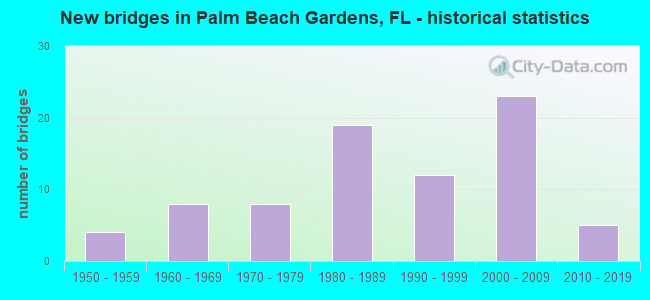
- New bridges - historical statistics
- 41950-1959
- 81960-1969
- 81970-1979
- 191980-1989
- 121990-1999
- 232000-2009
- 52010-2019

- Reconstructed bridges - Historical Statistics
- 41980-1989
- 31990-1999
- 62000-2009
- 12010-2019


- Bridge Condition - Deck
- 6.4%Excellent
- 6.4%Very good
- 78.7%Good
- 2.1%Satisfactory
- 6.4%Fair

- Bridge Condition - Superstructure
- 2.1%Excellent
- 19.1%Very good
- 63.8%Good
- 8.5%Satisfactory
- 6.4%Fair

- Bridge Condition - Substructure
- 8.5%Excellent
- 17.0%Very good
- 63.8%Good
- 10.6%Satisfactory

- Bridge Condition - Channel
- 17.9%Very good
- 71.4%Good
- 10.7%Satisfactory

- Bridge Condition - Culverts
- 20.0%Very good
- 20.0%Good
- 60.0%Satisfactory
Find on map >> Show street view
Structure Number: 930106, Location: 1000'W of SR5 & E ofSR811 (Lat: 26.844444, Lng: -80.066944), Route carried "on" structure: State highway 786, Year Built: 1966, Year Reconstructed: 2007, Status: Open, Structure Length: 11.81m (38.75ft), Average Daily Traffic: 19,750 (year 2021), Truck Traffic: 3%, Average Future Daily Traffic: 34,266 (year 2042), Design Load: HS 20, Features Intersected: Intracoastal Waterway, Facility Carried by Structure: EB PGA Blvd.
Minimum Vertical Clearance: 6.52m (21.39ft), Kilometerpoint: 13.314, Lanes on structure: 3, Base Highway Network: Yes, Owner: State Highway Agency, Approaching Roadway Width: 12.0m (39.4ft), Navigation Control: Yes ( Vertical Clearance: 6.4m (21.0ft), Horizontal Clearance: 27.4m (89.9ft)), Material/Design: Steel, Design/Construction: Movable - Bascule, Number Of Spans In Main Unit: 1, Number Of Approach Spans: 5, Length of Maximum Span: 32.4m (106.3ft), Curb or Sidewalk Widths: Left: 0.0m, Right: 1.8m (5.9ft), Curb-To-Curb Width: 12.0m (39.4ft), Out-to-Out Width: 14.8m (48.6ft)
Condition: Deck: Good, Superstructure: Good, Substructure: Satisfactory, Channel: Very good, Operating Rating: 66.3 metric tons, Method Used To Determine Operating Rating: Load Factor (LF), Inventory Rating: 39.7 metric tons, Method Used To Determine Inventory Rating: Load Factor (LF), Structural Evaluation: Equal to present minimum criteria, Deck Geometry: Meets minimum limits, Waterway Adequacy: Superior to present desirable criteria, Approach Roadway Alignment: Equal to present desirable criteria, Designated Inspection Frequency: Every 24 months, Critical Feature Inspection Frequency: Every 24 months, Underwater Inspection Frequency: Every 24 months, Other Special Inspection Frequency: Every 12 months, Inspection Date: May 2021, Critical Feature Inspection Date: May 2021, Underwater Inspection Date: May 2021, Other Special Inspection Date: May 2021, Deck Structure Type: Concrete Cast-file-Place
Find on map >> Show street view
Structure Number: 93012, Location: 3 Miles West of SR-786 (Lat: 26.872164, Lng: -80.245658), Route carried "on" structure: State highway 710, Year Built: 1957, Year Reconstructed: 1988, Status: Open, Structure Length: 3.66m (12.01ft), Average Daily Traffic: 6,550 (year 2020), Truck Traffic: 27%, Average Future Daily Traffic: 11,364 (year 2042), Design Load: HS 20, Features Intersected: C-18 Canal
Minimum Vertical Clearance: 30+ m (98+ ft), Kilometerpoint: 15.916, Lanes on structure: 2, Base Highway Network: Yes, Owner: State Highway Agency, Approaching Roadway Width: 9.1m (29.9ft), Material/Design: Concrete, Design/Construction: Slab, Number Of Spans In Main Unit: 6, Length of Maximum Span: 6.1m (20.0ft), Curb-To-Curb Width: 12.2m (40.0ft), Out-to-Out Width: 13.0m (42.7ft)
Condition: Deck: Satisfactory, Superstructure: Satisfactory, Substructure: Satisfactory, Channel: Good, Operating Rating: 57.2 metric tons, Method Used To Determine Operating Rating: Load Testing, Inventory Rating: 32.7 metric tons, Method Used To Determine Inventory Rating: Load Testing, Structural Evaluation: Equal to present minimum criteria, Deck Geometry: Better than present minimum criteria, Waterway Adequacy: Superior to present desirable criteria, Approach Roadway Alignment: Equal to present desirable criteria, Designated Inspection Frequency: Every 24 months, Underwater Inspection Frequency: Every 24 months, Inspection Date: May 2020, Underwater Inspection Date: May 2020, Deck Structure Type: Concrete Cast-file-Place
Find on map >> Show street view
Structure Number: 930121, Location: 0.5mi East of SR-786 (Lat: 26.835936, Lng: -80.191289), Route carried "on" structure: State highway 710, Year Built: 1957, Year Reconstructed: 1986, Status: Open, Structure Length: 0.64m (2.10ft), Average Daily Traffic: 12,600 (year 2020), Truck Traffic: 20%, Average Future Daily Traffic: 21,861 (year 2042), Design Load: HS 20+Mod, Features Intersected: Drainage Canal
Minimum Vertical Clearance: 30+ m (98+ ft), Kilometerpoint: 22.643, Lanes on structure: 4, Base Highway Network: Yes, Owner: State Highway Agency, Approaching Roadway Width: 18.6m (61.0ft), Skew: 10 degrees, Material/Design: Concrete, Design/Construction: Culvert, Number Of Spans In Main Unit: 2, Length of Maximum Span: 3.0m (9.8ft)
Condition: Channel: Good, Culverts: Satisfactory, Operating Rating: 43.4 metric tons, Method Used To Determine Operating Rating: Load Factor (LF), Inventory Rating: 26.0 metric tons, Method Used To Determine Inventory Rating: Load Factor (LF), Structural Evaluation: Equal to present minimum criteria, Waterway Adequacy: Equal to present desirable criteria, Approach Roadway Alignment: Equal to present desirable criteria, Designated Inspection Frequency: Every 24 months, Underwater Inspection Frequency: Every 24 months, Inspection Date: December 2020, Underwater Inspection Date: December 2020
Find on map >> Show street view
Structure Number: 930171, Location: 0.4 mile North of 45th St (Lat: 26.765556, Lng: -80.093750), Route carried "on" structure: Interstate 95, Year Built: 1967, Year Reconstructed: 2008, Status: Open, Structure Length: 1.02m (3.35ft), Average Daily Traffic: 188,000 (year 2020), Truck Traffic: 9%, Average Future Daily Traffic: 326,180 (year 2042), Design Load: HS 20+Mod, Features Intersected: Drainage Canal
Minimum Vertical Clearance: 30+ m (98+ ft), Kilometerpoint: 51.089, Lanes on structure: 12, Base Highway Network: Yes, Owner: State Highway Agency, Approaching Roadway Width: 31.6m (103.7ft), Skew: 32 degrees, Material/Design: Concrete, Design/Construction: Culvert, Number Of Spans In Main Unit: 3, Length of Maximum Span: 3.4m (11.2ft)
Condition: Channel: Good, Culverts: Satisfactory, Operating Rating: 58.9 metric tons, Method Used To Determine Operating Rating: Load Factor (LF), Inventory Rating: 35.4 metric tons, Method Used To Determine Inventory Rating: Load Factor (LF), Structural Evaluation: Equal to present minimum criteria, Waterway Adequacy: Superior to present desirable criteria, Approach Roadway Alignment: Equal to present desirable criteria, Designated Inspection Frequency: Every 24 months, Underwater Inspection Frequency: Every 24 months, Inspection Date: May 2020, Underwater Inspection Date: May 2020, Wearing Surface/Protective System: Wearing Surface: Bituminous
Find on map >> Show street view
Structure Number: 930178, Location: 0.5 mi. N of N Lakes Blvd (Lat: 26.817083, Lng: -80.097917), Route carried "on" structure: Interstate 95, Year Built: 1967, Year Reconstructed: 2004, Status: Open, Structure Length: 1.19m (3.90ft), Average Daily Traffic: 152,000 (year 2020), Truck Traffic: 9%, Average Future Daily Traffic: 263,720 (year 2042), Design Load: HS 20, Features Intersected: Triple box culvert
Minimum Vertical Clearance: 30+ m (98+ ft), Kilometerpoint: 56.890, Lanes on structure: 11, Base Highway Network: Yes, Owner: State Highway Agency, Approaching Roadway Width: 54.3m (178.1ft), Skew: 30 degrees, Material/Design: Concrete, Design/Construction: Culvert, Number Of Spans In Main Unit: 3, Length of Maximum Span: 3.7m (12.1ft)
Condition: Channel: Good, Culverts: Good, Operating Rating: 63.4 metric tons, Method Used To Determine Operating Rating: Load Factor (LF), Inventory Rating: 38.1 metric tons, Method Used To Determine Inventory Rating: Load Factor (LF), Structural Evaluation: Better than present minimum criteria, Waterway Adequacy: Superior to present desirable criteria, Approach Roadway Alignment: Equal to present desirable criteria, Designated Inspection Frequency: Every 24 months, Underwater Inspection Frequency: Every 24 months, Inspection Date: May 2020, Underwater Inspection Date: May 2020, Wearing Surface/Protective System: Wearing Surface: Bituminous
Find on map >> Show street view
Structure Number: 930265, Location: Tpk/PGA Blvd interchange (Lat: 26.839183, Lng: -80.129692), Route carried "on" structure: State highway 786, Year Built: 1976, Year Reconstructed: 1997, Status: Open, Structure Length: 6.02m (19.75ft), Average Daily Traffic: 23,000 (year 2021), Truck Traffic: 7%, Average Future Daily Traffic: 39,905 (year 2042), Design Load: HS 20+Mod, Features Intersected: FL. TPK. SR-91
Minimum Vertical Clearance: 30+ m (98+ ft), Kilometerpoint: 6.809, Lanes on structure: 6, Lanes under structure: 4, Base Highway Network: Yes, Owner: State Highway Agency, Approaching Roadway Width: 19.5m (64.0ft), Skew: 20 degrees, Material/Design: Prestressed concrete, Design/Construction: Stringer/Multi-beam, Number Of Spans In Main Unit: 4, Length of Maximum Span: 18.7m (61.4ft), Curb or Sidewalk Widths: Left: 1.5m (4.9ft), Right: 1.5m (4.9ft), Curb-To-Curb Width: 32.4m (106.3ft), Out-to-Out Width: 36.9m (121.1ft)
Condition: Deck: Good, Superstructure: Satisfactory, Substructure: Good, Operating Rating: 41.3 metric tons, Method Used To Determine Operating Rating: Load and Resistance Factor (LRFR), Inventory Rating: 31.8 metric tons, Method Used To Determine Inventory Rating: Load and Resistance Factor (LRFR), Structural Evaluation: Equal to present minimum criteria, Deck Geometry: Superior to present desirable criteria, Underclear: Somewhat better than minimum adequacy, Approach Roadway Alignment: Equal to present desirable criteria, Designated Inspection Frequency: Every 24 months, Inspection Date: July 2021, Deck Structure Type: Concrete Cast-file-Place
Find on map >> Show street view
Structure Number: 930267, Location: 0.8MI E OF I-95 (Lat: 26.808472, Lng: -80.085814), Route carried "on" structure: County highway 809, Year Built: 1976, Status: Open, Structure Length: 4.88m (16.01ft), Average Daily Traffic: 55,500 (year 2020), Truck Traffic: 7%, Average Future Daily Traffic: 96,292 (year 2042), Design Load: HS 20, Features Intersected: LWDD C-17 CANAL, Facility Carried by Structure: N. LAKE BLVD WB
Minimum Vertical Clearance: 30+ m (98+ ft), Kilometerpoint: 8.464, Lanes on structure: 3, Owner: County Highway Agency, Approaching Roadway Width: 13.0m (42.7ft), Material/Design: Prestressed concrete, Design/Construction: Slab, Number Of Spans In Main Unit: 5, Length of Maximum Span: 9.8m (32.2ft), Curb or Sidewalk Widths: Left: 1.6m (5.2ft), Right: 0.0m, Curb-To-Curb Width: 12.9m (42.3ft), Out-to-Out Width: 15.0m (49.2ft)
Condition: Deck: Good, Superstructure: Good, Substructure: Good, Channel: Good, Operating Rating: 76.9 metric tons, Method Used To Determine Operating Rating: Allowable Stress (AS), Inventory Rating: 48.2 metric tons, Method Used To Determine Inventory Rating: Allowable Stress (AS), Structural Evaluation: Better than present minimum criteria, Deck Geometry: Meets minimum limits, Waterway Adequacy: Equal to present desirable criteria, Approach Roadway Alignment: Equal to present desirable criteria, Designated Inspection Frequency: Every 24 months, Underwater Inspection Frequency: Every 24 months, Inspection Date: April 2020, Underwater Inspection Date: April 2020, Deck Structure Type: Concrete Precast Panels, Wearing Surface/Protective System: Wearing Surface: Bituminous
Find on map >> Show street view
Structure Number: 930268, Location: 0.8MI EAST OF I-95 (Lat: 26.808311, Lng: -80.085817), Route carried "on" structure: County highway 809, Year Built: 1976, Status: Open, Structure Length: 4.88m (16.01ft), Average Daily Traffic: 55,500 (year 2020), Truck Traffic: 7%, Average Future Daily Traffic: 96,292 (year 2042), Design Load: HS 20, Features Intersected: LWDD C-17 CANAL, Facility Carried by Structure: N. LAKE BLVD EB
Minimum Vertical Clearance: 30+ m (98+ ft), Kilometerpoint: 8.464, Lanes on structure: 3, Owner: County Highway Agency, Approaching Roadway Width: 12.9m (42.3ft), Material/Design: Prestressed concrete, Design/Construction: Slab, Number Of Spans In Main Unit: 5, Length of Maximum Span: 9.8m (32.2ft), Curb or Sidewalk Widths: Left: 0.0m, Right: 1.6m (5.2ft), Curb-To-Curb Width: 12.9m (42.3ft), Out-to-Out Width: 15.0m (49.2ft)
Condition: Deck: Good, Superstructure: Good, Substructure: Good, Channel: Satisfactory, Operating Rating: 76.9 metric tons, Method Used To Determine Operating Rating: Allowable Stress (AS), Inventory Rating: 48.2 metric tons, Method Used To Determine Inventory Rating: Allowable Stress (AS), Structural Evaluation: Better than present minimum criteria, Deck Geometry: Meets minimum limits, Waterway Adequacy: Equal to present desirable criteria, Approach Roadway Alignment: Equal to present desirable criteria, Designated Inspection Frequency: Every 24 months, Underwater Inspection Frequency: Every 24 months, Inspection Date: April 2020, Underwater Inspection Date: April 2020, Deck Structure Type: Concrete Precast Panels, Wearing Surface/Protective System: Wearing Surface: Bituminous
Find on map >> Show street view
Structure Number: 930335, Location: 1mi. N of North Lake Blvd (Lat: 26.839514, Lng: -80.102039), Route carried "on" structure: Interstate 95, Year Built: 1978, Year Reconstructed: 2011, Status: Open, Structure Length: 6.75m (22.15ft), Average Daily Traffic: 56,250 (year 2020), Truck Traffic: 9%, Average Future Daily Traffic: 97,594 (year 2042), Design Load: HL 93, Features Intersected: PGA Blvd SR 786
Minimum Vertical Clearance: 30+ m (98+ ft), Kilometerpoint: 59.443, Lanes on structure: 5, Lanes under structure: 7, Base Highway Network: Yes, Owner: State Highway Agency, Approaching Roadway Width: 25.6m (84.0ft), Skew: 1 degrees, Material/Design: Prestressed concrete, Design/Construction: Stringer/Multi-beam, Number Of Spans In Main Unit: 2, Length of Maximum Span: 35.8m (117.5ft), Curb-To-Curb Width: 26.9m (88.3ft), Out-to-Out Width: 27.9m (91.5ft)
Condition: Deck: Good, Superstructure: Satisfactory, Substructure: Good, Operating Rating: 40.2 metric tons, Method Used To Determine Operating Rating: Load and Resistance Factor (LRFR), Inventory Rating: 36.6 metric tons, Method Used To Determine Inventory Rating: Load and Resistance Factor (LRFR), Structural Evaluation: Equal to present minimum criteria, Deck Geometry: Superior to present desirable criteria, Underclear: Equal to present minimum criteria, Approach Roadway Alignment: Equal to present desirable criteria, Designated Inspection Frequency: Every 24 months, Inspection Date: March 2020, Deck Structure Type: Concrete Cast-file-Place
Find on map >> Show street view
Structure Number: 930336, Location: 1mi. N of Northlake Blvd. (Lat: 26.839736, Lng: -80.101828), Route carried "on" structure: Interstate 95, Year Built: 1978, Year Reconstructed: 2011, Status: Open, Structure Length: 6.83m (22.41ft), Average Daily Traffic: 56,250 (year 2020), Truck Traffic: 9%, Average Future Daily Traffic: 97,594 (year 2042), Design Load: HL 93, Features Intersected: SR 786 PGA Blvd
Minimum Vertical Clearance: 30+ m (98+ ft), Kilometerpoint: 59.443, Lanes on structure: 6, Lanes under structure: 6, Base Highway Network: Yes, Owner: State Highway Agency, Approaching Roadway Width: 25.6m (84.0ft), Skew: 1 degrees, Material/Design: Prestressed concrete, Design/Construction: Stringer/Multi-beam, Number Of Spans In Main Unit: 2, Length of Maximum Span: 36.3m (119.1ft), Curb-To-Curb Width: 30.6m (100.4ft), Out-to-Out Width: 31.5m (103.3ft)
Condition: Deck: Good, Superstructure: Satisfactory, Substructure: Very good, Operating Rating: 36.9 metric tons, Method Used To Determine Operating Rating: Load and Resistance Factor (LRFR), Inventory Rating: 33.3 metric tons, Method Used To Determine Inventory Rating: Load and Resistance Factor (LRFR), Structural Evaluation: Equal to present minimum criteria, Deck Geometry: Superior to present desirable criteria, Underclear: Equal to present minimum criteria, Approach Roadway Alignment: Equal to present desirable criteria, Designated Inspection Frequency: Every 24 months, Inspection Date: March 2020, Deck Structure Type: Concrete Cast-file-Place
Find on map >> Show street view
Structure Number: 930344, Location: .5mi W. of N. Lake Blvd. (Lat: 26.812472, Lng: -80.156219), Route carried "on" structure: State highway 710, Year Built: 1958, Year Reconstructed: 1986, Status: Open, Structure Length: 0.63m (2.07ft), Average Daily Traffic: 13,600 (year 2020), Truck Traffic: 19%, Average Future Daily Traffic: 23,596 (year 2042), Design Load: HS 20, Features Intersected: C-18 Canal
Minimum Vertical Clearance: 30+ m (98+ ft), Kilometerpoint: 27.076, Lanes on structure: 5, Owner: State Highway Agency, Approaching Roadway Width: 30.5m (100.1ft), Skew: 13 degrees, Material/Design: Concrete, Design/Construction: Culvert, Number Of Spans In Main Unit: 2, Length of Maximum Span: 3.0m (9.8ft)
Condition: Channel: Good, Culverts: Satisfactory, Operating Rating: 64.1 metric tons, Method Used To Determine Operating Rating: Load Factor (LF), Inventory Rating: 38.5 metric tons, Method Used To Determine Inventory Rating: Load Factor (LF), Structural Evaluation: Equal to present minimum criteria, Waterway Adequacy: Superior to present desirable criteria, Approach Roadway Alignment: Equal to present desirable criteria, Designated Inspection Frequency: Every 24 months, Underwater Inspection Frequency: Every 24 months, Inspection Date: June 2020, Underwater Inspection Date: June 2020
Find on map >> Show street view
Structure Number: 930349, Location: 1000'W of SR5 & E ofSR811 (Lat: 26.844717, Lng: -80.065894), Route carried "on" structure: State highway 786, Year Built: 1982, Year Reconstructed: 2007, Status: Open, Structure Length: 11.81m (38.75ft), Average Daily Traffic: 19,750 (year 2021), Truck Traffic: 3%, Average Future Daily Traffic: 34,266 (year 2042), Design Load: HS 20, Features Intersected: Intracoastal Waterway, Facility Carried by Structure: WB PGA Blvd.
Minimum Vertical Clearance: 6.52m (21.39ft), Kilometerpoint: 13.314, Lanes on structure: 3, Base Highway Network: Yes, Owner: State Highway Agency, Approaching Roadway Width: 12.0m (39.4ft), Navigation Control: Yes ( Vertical Clearance: 6.2m (20.3ft), Horizontal Clearance: 27.4m (89.9ft)), Material/Design: Steel, Design/Construction: Movable - Bascule, Number Of Spans In Main Unit: 1, Number Of Approach Spans: 5, Length of Maximum Span: 43.3m (142.1ft), Curb or Sidewalk Widths: Left: 2.3m (7.5ft), Right: 0.0m, Curb-To-Curb Width: 12.0m (39.4ft), Out-to-Out Width: 15.3m (50.2ft)
Condition: Deck: Good, Superstructure: Very good, Substructure: Satisfactory, Channel: Good, Operating Rating: 52.3 metric tons, Method Used To Determine Operating Rating: Load Factor (LF), Inventory Rating: 31.4 metric tons, Method Used To Determine Inventory Rating: Load Factor (LF), Structural Evaluation: Equal to present minimum criteria, Deck Geometry: Meets minimum limits, Waterway Adequacy: Superior to present desirable criteria, Approach Roadway Alignment: Equal to present desirable criteria, Designated Inspection Frequency: Every 24 months, Critical Feature Inspection Frequency: Every 24 months, Underwater Inspection Frequency: Every 24 months, Other Special Inspection Frequency: Every 12 months, Inspection Date: May 2021, Critical Feature Inspection Date: May 2021, Underwater Inspection Date: May 2021, Other Special Inspection Date: May 2021, Deck Structure Type: Concrete Cast-file-Place
Find on map >> Show street view
Structure Number: 930356, Location: PGA Blvd 2.3mi. W of TPK. (Lat: 26.840042, Lng: -80.166667), Route carried "on" structure: State highway 786, Year Built: 1963, Year Reconstructed: 1987, Status: Open, Structure Length: 3.81m (12.50ft), Average Daily Traffic: 3,700 (year 2020), Truck Traffic: 10%, Average Future Daily Traffic: 6,420 (year 2042), Design Load: HS 20, Features Intersected: C-18 CANAL
Minimum Vertical Clearance: 30+ m (98+ ft), Kilometerpoint: 3.182, Lanes on structure: 2, Base Highway Network: Yes, Owner: State Highway Agency, Approaching Roadway Width: 8.2m (26.9ft), Skew: 2 degrees, Material/Design: Prestressed concrete, Design/Construction: Slab, Number Of Spans In Main Unit: 5, Length of Maximum Span: 7.6m (24.9ft), Curb-To-Curb Width: 10.4m (34.1ft), Out-to-Out Width: 11.3m (37.1ft)
Condition: Deck: Fair, Superstructure: Fair, Substructure: Satisfactory, Channel: Satisfactory, Inventory Rating: 55.3 metric tons, Method Used To Determine Inventory Rating: Load Factor (LF), Structural Evaluation: Somewhat better than minimum adequacy, Deck Geometry: Somewhat better than minimum adequacy, Waterway Adequacy: Superior to present desirable criteria, Approach Roadway Alignment: Equal to present desirable criteria, Designated Inspection Frequency: Every 24 months, Underwater Inspection Frequency: Every 24 months, Inspection Date: June 2020, Underwater Inspection Date: June 2020, Deck Structure Type: Concrete Precast Panels, Wearing Surface/Protective System: Wearing Surface: Bituminous
Find on map >> Show street view
Structure Number: 930362, Location: 3 Miles West of SR-786 (Lat: 26.872292, Lng: -80.245525), Route carried "on" structure: State highway 710, Year Built: 1988, Status: Open, Structure Length: 3.66m (12.01ft), Average Daily Traffic: 6,550 (year 2020), Truck Traffic: 27%, Average Future Daily Traffic: 11,364 (year 2042), Design Load: HS 20, Features Intersected: C-18 Canal
Minimum Vertical Clearance: 30+ m (98+ ft), Kilometerpoint: 15.916, Lanes on structure: 2, Base Highway Network: Yes, Owner: State Highway Agency, Approaching Roadway Width: 9.1m (29.9ft), Material/Design: Concrete continuous, Design/Construction: Slab, Number Of Spans In Main Unit: 4, Length of Maximum Span: 10.1m (33.1ft), Curb-To-Curb Width: 12.2m (40.0ft), Out-to-Out Width: 13.0m (42.7ft)
Condition: Deck: Good, Superstructure: Good, Substructure: Satisfactory, Channel: Good, Operating Rating: 47.4 metric tons, Method Used To Determine Operating Rating: Load Testing, Inventory Rating: 32.7 metric tons, Method Used To Determine Inventory Rating: Load Testing, Structural Evaluation: Equal to present minimum criteria, Deck Geometry: Better than present minimum criteria, Waterway Adequacy: Superior to present desirable criteria, Approach Roadway Alignment: Equal to present desirable criteria, Designated Inspection Frequency: Every 24 months, Underwater Inspection Frequency: Every 24 months, Inspection Date: May 2020, Underwater Inspection Date: May 2020, Deck Structure Type: Concrete Cast-file-Place
Find on map >> Show street view
Structure Number: 930378, Location: 0.25 mile North of SR 786 (Lat: 26.844444, Lng: -80.105056), Route carried "on" structure: Interstate 95, Year Built: 1986, Year Reconstructed: 2011, Status: Open, Structure Length: 11.54m (37.86ft), Average Daily Traffic: 129,500 (year 2021), Truck Traffic: 9%, Average Future Daily Traffic: 224,682 (year 2042), Design Load: HL 93, Features Intersected: Military Trail
Minimum Vertical Clearance: 30+ m (98+ ft), Kilometerpoint: 60.074, Lanes on structure: 12, Lanes under structure: 7, Base Highway Network: Yes, Owner: State Highway Agency, Approaching Roadway Width: 51.2m (168.0ft), Skew: 35 degrees, Material/Design: Prestressed concrete, Design/Construction: Stringer/Multi-beam, Number Of Spans In Main Unit: 4, Length of Maximum Span: 37.2m (122.0ft), Curb-To-Curb Width: 61.6m (202.1ft), Out-to-Out Width: 63.4m (208.0ft)
Condition: Deck: Good, Superstructure: Very good, Substructure: Very good, Operating Rating: 37.6 metric tons, Method Used To Determine Operating Rating: Load and Resistance Factor (LRFR), Inventory Rating: 32.7 metric tons, Method Used To Determine Inventory Rating: Load and Resistance Factor (LRFR), Structural Evaluation: Equal to present desirable criteria, Deck Geometry: Superior to present desirable criteria, Underclear: Meets minimum limits, Approach Roadway Alignment: Equal to present desirable criteria, Designated Inspection Frequency: Every 24 months, Inspection Date: March 2021, Deck Structure Type: Concrete Cast-file-Place
Find on map >> Show street view
Structure Number: 930379, Location: 1 mile North of SR 786 (Lat: 26.857783, Lng: -80.113614), Route carried "on" structure: County highway , Year Built: 1986, Status: Open, Structure Length: 9.03m (29.63ft), Average Daily Traffic: 17,800 (year 2021), Truck Traffic: 5%, Average Future Daily Traffic: 30,883 (year 2042), Design Load: HS 20+Mod, Features Intersected: I 95 SR 9, Facility Carried by Structure: Central Blvd
Minimum Vertical Clearance: 30+ m (98+ ft), Kilometerpoint: 2.377, Lanes on structure: 4, Lanes under structure: 10, Owner: State Highway Agency, Approaching Roadway Width: 27.4m (89.9ft), Skew: 21 degrees, Material/Design: Prestressed concrete, Design/Construction: Stringer/Multi-beam, Number Of Spans In Main Unit: 4, Length of Maximum Span: 36.1m (118.4ft), Curb or Sidewalk Widths: Left: 1.5m (4.9ft), Right: 2.4m (7.9ft), Curb-To-Curb Width: 27.4m (89.9ft), Out-to-Out Width: 32.8m (107.6ft)
Condition: Deck: Good, Superstructure: Good, Substructure: Good, Operating Rating: 67.0 metric tons, Method Used To Determine Operating Rating: Load Factor (LF), Inventory Rating: 31.8 metric tons, Method Used To Determine Inventory Rating: Load Factor (LF), Structural Evaluation: Better than present minimum criteria, Deck Geometry: Superior to present desirable criteria, Underclear: Equal to present minimum criteria, Approach Roadway Alignment: Equal to present desirable criteria, Designated Inspection Frequency: Every 24 months, Inspection Date: March 2021, Deck Structure Type: Concrete Cast-file-Place
Find on map >> Show street view
Structure Number: 930381, Location: 3 MI NORTH OF PGA BLVD (Lat: 26.883014, Lng: -80.131103), Route carried "on" structure: City street 91, Year Built: 1986, Status: Open, Structure Length: 6.68m (21.92ft), Average Daily Traffic: 44,700 (year 2021), Truck Traffic: 16%, Average Future Daily Traffic: 77,554 (year 2042), Design Load: HS 20+Mod, Features Intersected: SR 91 TPK, Facility Carried by Structure: DNLD RS RD W 112.2
Minimum Vertical Clearance: 30+ m (98+ ft), Kilometerpoint: 62.821, Lanes on structure: 2, Lanes under structure: 4, Owner: State Toll Authority, Approaching Roadway Width: 16.8m (55.1ft), Skew: 1 degrees, Material/Design: Prestressed concrete, Design/Construction: Stringer/Multi-beam, Number Of Spans In Main Unit: 2, Length of Maximum Span: 33.3m (109.3ft), Curb or Sidewalk Widths: Left: 1.8m (5.9ft), Right: 0.0m, Curb-To-Curb Width: 16.3m (53.5ft), Out-to-Out Width: 18.7m (61.4ft)
Condition: Deck: Excellent, Superstructure: Good, Substructure: Excellent, Operating Rating: 43.1 metric tons, Method Used To Determine Operating Rating: Load and Resistance Factor (LRFR), Inventory Rating: 30.0 metric tons, Method Used To Determine Inventory Rating: Load and Resistance Factor (LRFR), Structural Evaluation: Better than present minimum criteria, Deck Geometry: Superior to present desirable criteria, Underclear: Equal to present minimum criteria, Approach Roadway Alignment: Equal to present desirable criteria, Length Of Structure Improvement: 6.64m (21.78ft), Designated Inspection Frequency: Every 24 months, Inspection Date: November 2021, Bridge Improvement Cost: $23,000, Total Project Cost: $23,000, Deck Structure Type: Concrete Cast-file-Place
Find on map >> Show street view
Structure Number: 930388, Location: I 95 SR 786 Interchange (Lat: 26.840556, Lng: -80.102694), Route carried "on" structure: Ramp State highway 786, Year Built: 1986, Status: Open, Structure Length: 36.61m (120.11ft), Average Daily Traffic: 14,500 (year 2021), Truck Traffic: 3%, Average Future Daily Traffic: 25,158 (year 2042), Design Load: HS 20+Mod, Features Intersected: SR786 I95 I95 Ramps
Minimum Vertical Clearance: 30+ m (98+ ft), Kilometerpoint: 0.431, Lanes on structure: 1, Lanes under structure: 18, Owner: State Highway Agency, Approaching Roadway Width: 8.2m (26.9ft), Material/Design: Steel continuous, Design/Construction: Stringer/Multi-beam, Number Of Spans In Main Unit: 3, Number Of Approach Spans: 7, Length of Maximum Span: 60.4m (198.2ft), Curb-To-Curb Width: 8.2m (26.9ft), Out-to-Out Width: 9.1m (29.9ft)
Condition: Deck: Good, Superstructure: Very good, Substructure: Good, Operating Rating: 46.2 metric tons, Method Used To Determine Operating Rating: Load Factor (LF), Inventory Rating: 39.9 metric tons, Method Used To Determine Inventory Rating: Load Factor (LF), Structural Evaluation: Better than present minimum criteria, Deck Geometry: Superior to present desirable criteria, Underclear: Somewhat better than minimum adequacy, Approach Roadway Alignment: Equal to present desirable criteria, Designated Inspection Frequency: Every 24 months, Inspection Date: March 2021, Deck Structure Type: Concrete Cast-file-Place
Find on map >> Show street view
Structure Number: 930398, Location: 1.5 mile North of SR 786 (Lat: 26.864847, Lng: -80.117675), Route carried "on" structure: County highway , Year Built: 1987, Year Reconstructed: 2019, Status: Open, Structure Length: 10.74m (35.24ft), Average Daily Traffic: 5,200 (year 2021), Truck Traffic: 7%, Average Future Daily Traffic: 9,022 (year 2042), Design Load: HS 20, Features Intersected: I 95 SR 9, Facility Carried by Structure: EB Hood Road
Minimum Vertical Clearance: 30+ m (98+ ft), Kilometerpoint: 2.636, Lanes on structure: 2, Lanes under structure: 10, Owner: State Highway Agency, Approaching Roadway Width: 7.0m (23.0ft), Skew: 3 degrees, Material/Design: Prestressed concrete, Design/Construction: Stringer/Multi-beam, Number Of Spans In Main Unit: 4, Length of Maximum Span: 43.8m (143.7ft), Curb or Sidewalk Widths: Left: 0.0m, Right: 2.2m (7.2ft), Curb-To-Curb Width: 10.7m (35.1ft), Out-to-Out Width: 14.3m (46.9ft)
Condition: Deck: Good, Superstructure: Good, Substructure: Very good, Operating Rating: 66.2 metric tons, Method Used To Determine Operating Rating: Load Testing, Inventory Rating: 39.0 metric tons, Method Used To Determine Inventory Rating: Load Testing, Structural Evaluation: Better than present minimum criteria, Deck Geometry: Somewhat better than minimum adequacy, Underclear: Equal to present minimum criteria, Approach Roadway Alignment: Equal to present desirable criteria, Designated Inspection Frequency: Every 24 months, Inspection Date: September 2021, Deck Structure Type: Concrete Cast-file-Place
Find on map >> Show street view
Structure Number: 930419, Location: N.OF PGA BLVD S.JUPITER (Lat: 26.882858, Lng: -80.131039), Route carried "on" structure: City street 91, Year Built: 1986, Status: Open, Structure Length: 6.68m (21.92ft), Average Daily Traffic: 44,700 (year 2021), Truck Traffic: 16%, Average Future Daily Traffic: 77,554 (year 2042), Design Load: HS 20+Mod, Features Intersected: SR 91 TPK, Facility Carried by Structure: DNLD RS RD E 112.2
Minimum Vertical Clearance: 30+ m (98+ ft), Kilometerpoint: 62.800, Lanes on structure: 2, Lanes under structure: 4, Toll: On toll road, Owner: State Toll Authority, Approaching Roadway Width: 16.1m (52.8ft), Skew: 1 degrees, Material/Design: Prestressed concrete, Design/Construction: Stringer/Multi-beam, Number Of Spans In Main Unit: 2, Length of Maximum Span: 33.4m (109.6ft), Curb or Sidewalk Widths: Left: 0.0m, Right: 1.8m (5.9ft), Curb-To-Curb Width: 16.8m (55.1ft), Out-to-Out Width: 18.7m (61.4ft)
Condition: Deck: Very good, Superstructure: Good, Substructure: Excellent, Operating Rating: 43.1 metric tons, Method Used To Determine Operating Rating: Load and Resistance Factor (LRFR), Inventory Rating: 30.0 metric tons, Method Used To Determine Inventory Rating: Load and Resistance Factor (LRFR), Structural Evaluation: Better than present minimum criteria, Deck Geometry: Superior to present desirable criteria, Underclear: Equal to present minimum criteria, Approach Roadway Alignment: Equal to present desirable criteria, Designated Inspection Frequency: Every 24 months, Inspection Date: November 2021, Deck Structure Type: Concrete Cast-file-Place
Find on map >> Show street view
Structure Number: 930441, Location: 1.8 MI N OF PGA BLV/SR786 (Lat: 26.865356, Lng: -80.128972), Route carried "on" structure: Business City street , Year Built: 1992, Status: Open, Structure Length: 4.94m (16.21ft), Average Daily Traffic: 44,700 (year 2021), Truck Traffic: 16%, Average Future Daily Traffic: 77,554 (year 2042), Design Load: HS 20+Mod, Features Intersected: SR 91 TPK, Facility Carried by Structure: HOOD RD 110.944
Minimum Vertical Clearance: 30+ m (98+ ft), Kilometerpoint: 60.831, Lanes on structure: 2, Lanes under structure: 4, Owner: State Toll Authority, Approaching Roadway Width: 10.3m (33.8ft), Material/Design: Prestressed concrete, Design/Construction: Stringer/Multi-beam, Number Of Spans In Main Unit: 2, Length of Maximum Span: 24.7m (81.0ft), Curb or Sidewalk Widths: Left: 1.8m (5.9ft), Right: 0.0m, Curb-To-Curb Width: 11.7m (38.4ft), Out-to-Out Width: 13.1m (43.0ft)
Condition: Deck: Good, Superstructure: Very good, Substructure: Very good, Operating Rating: 45.7 metric tons, Method Used To Determine Operating Rating: Load and Resistance Factor (LRFR), Inventory Rating: 38.8 metric tons, Method Used To Determine Inventory Rating: Load and Resistance Factor (LRFR), Structural Evaluation: Equal to present desirable criteria, Deck Geometry: Somewhat better than minimum adequacy, Underclear: Somewhat better than minimum adequacy, Approach Roadway Alignment: Better than present minimum criteria, Designated Inspection Frequency: Every 24 months, Inspection Date: November 2021, Deck Structure Type: Concrete Cast-file-Place
Find on map >> Show street view
Structure Number: 930491, Location: 1st overpass east of I-95 (Lat: 26.843606, Lng: -80.095414), Route carried "on" structure: State highway 786, Year Built: 2003, Status: Open, Structure Length: 12.53m (41.11ft), Average Daily Traffic: 34,500 (year 2020), Truck Traffic: 4%, Average Future Daily Traffic: 59,858 (year 2042), Design Load: HS 20+Mod, Features Intersected: SR 811 & FEC RR
Minimum Vertical Clearance: 30+ m (98+ ft), Kilometerpoint: 10.412, Lanes on structure: 4, Lanes under structure: 8, Base Highway Network: Yes, Owner: State Highway Agency, Approaching Roadway Width: 17.7m (58.1ft), Material/Design: Prestressed concrete, Design/Construction: Stringer/Multi-beam, Number Of Spans In Main Unit: 3, Length of Maximum Span: 47.3m (155.2ft), Curb or Sidewalk Widths: Left: 0.0m, Right: 2.4m (7.9ft), Curb-To-Curb Width: 20.4m (66.9ft), Out-to-Out Width: 24.0m (78.7ft)
Condition: Deck: Good, Superstructure: Good, Substructure: Good, Operating Rating: 69.6 metric tons, Method Used To Determine Operating Rating: Load Factor (LF), Inventory Rating: 39.6 metric tons, Method Used To Determine Inventory Rating: Load Factor (LF), Structural Evaluation: Better than present minimum criteria, Deck Geometry: Superior to present desirable criteria, Underclear: Superior to present desirable criteria, Approach Roadway Alignment: Equal to present desirable criteria, Designated Inspection Frequency: Every 24 months, Inspection Date: October 2020, Deck Structure Type: Concrete Cast-file-Place
Find on map >> Show street view
Structure Number: 930492, Location: 1st overpass east of I-95 (Lat: 26.843808, Lng: -80.095456), Route carried "on" structure: State highway 786, Year Built: 2003, Status: Open, Structure Length: 12.53m (41.11ft), Average Daily Traffic: 34,500 (year 2020), Truck Traffic: 4%, Average Future Daily Traffic: 59,858 (year 2042), Design Load: HS 20+Mod, Features Intersected: SR 811 & FEC RR
Minimum Vertical Clearance: 30+ m (98+ ft), Kilometerpoint: 10.412, Lanes on structure: 3, Lanes under structure: 8, Base Highway Network: Yes, Owner: State Highway Agency, Approaching Roadway Width: 14.1m (46.3ft), Material/Design: Prestressed concrete, Design/Construction: Stringer/Multi-beam, Number Of Spans In Main Unit: 3, Length of Maximum Span: 47.3m (155.2ft), Curb-To-Curb Width: 16.8m (55.1ft), Out-to-Out Width: 17.7m (58.1ft)
Condition: Deck: Good, Superstructure: Very good, Substructure: Good, Operating Rating: 69.7 metric tons, Method Used To Determine Operating Rating: Load Factor (LF), Inventory Rating: 39.8 metric tons, Method Used To Determine Inventory Rating: Load Factor (LF), Structural Evaluation: Better than present minimum criteria, Deck Geometry: Superior to present desirable criteria, Underclear: Superior to present desirable criteria, Approach Roadway Alignment: Equal to present desirable criteria, Designated Inspection Frequency: Every 24 months, Inspection Date: October 2020, Deck Structure Type: Concrete Cast-file-Place
Find on map >> Show street view
Structure Number: 930493, Location: NW quad SR811/786 intchge (Lat: 26.845181, Lng: -80.095917), Route carried "on" structure: Ramp State highway 811, Year Built: 2004, Status: Open, Structure Length: 20.03m (65.72ft), Average Daily Traffic: 12,500 (year 2021), Truck Traffic: 5%, Average Future Daily Traffic: 21,688 (year 2042), Design Load: HS 20+Mod, Features Intersected: RCA Center Dr & FEC R/R
Minimum Vertical Clearance: 30+ m (98+ ft), Kilometerpoint: 0.338, Lanes on structure: 1, Lanes under structure: 2, Owner: State Highway Agency, Approaching Roadway Width: 8.1m (26.6ft), Material/Design: Steel continuous, Design/Construction: Box Beam or Girders - Single/Spread, Number Of Spans In Main Unit: 3, Length of Maximum Span: 90.8m (297.9ft), Curb-To-Curb Width: 9.3m (30.5ft), Out-to-Out Width: 10.2m (33.5ft)
Condition: Deck: Good, Superstructure: Good, Substructure: Good, Operating Rating: 61.4 metric tons, Method Used To Determine Operating Rating: Load Factor (LF), Inventory Rating: 36.9 metric tons, Method Used To Determine Inventory Rating: Load Factor (LF), Structural Evaluation: Better than present minimum criteria, Deck Geometry: Superior to present desirable criteria, Underclear: Superior to present desirable criteria, Approach Roadway Alignment: Equal to present desirable criteria, Designated Inspection Frequency: Every 24 months, Critical Feature Inspection Frequency: Every 12 months, Inspection Date: October 2020, Critical Feature Inspection Date: October 2021, Deck Structure Type: Concrete Cast-file-Place
Find on map >> Show street view
Structure Number: 930516, Location: Between SR 710 and 786 (Lat: 26.808792, Lng: -80.098250), Route carried "on" structure: Interstate 95, Year Built: 2005, Status: Open, Structure Length: 6.22m (20.41ft), Average Daily Traffic: 187,500 (year 2021), Truck Traffic: 8%, Average Future Daily Traffic: 325,312 (year 2042), Design Load: HS 20+Mod, Features Intersected: Northlake Blvd.
Minimum Vertical Clearance: 30+ m (98+ ft), Kilometerpoint: 55.891, Lanes on structure: 10, Lanes under structure: 10, Base Highway Network: Yes, Owner: State Highway Agency, Approaching Roadway Width: 54.3m (178.1ft), Skew: 30 degrees, Material/Design: Prestressed concrete, Design/Construction: Stringer/Multi-beam, Number Of Spans In Main Unit: 2, Length of Maximum Span: 31.1m (102.0ft), Curb-To-Curb Width: 54.3m (178.1ft), Out-to-Out Width: 55.8m (183.1ft)
Condition: Deck: Good, Superstructure: Good, Substructure: Very good, Inventory Rating: 57.2 metric tons, Method Used To Determine Inventory Rating: Load Factor (LF), Structural Evaluation: Better than present minimum criteria, Deck Geometry: Superior to present desirable criteria, Underclear: Better than present minimum criteria, Approach Roadway Alignment: Equal to present desirable criteria, Designated Inspection Frequency: Every 24 months, Inspection Date: March 2021, Deck Structure Type: Concrete Cast-file-Place
Find on map >> Show street view
Structure Number: 930517, Location: Between N Lake/PGA Blvds. (Lat: 26.823611, Lng: -80.097778), Route carried "on" structure: Interstate 95, Year Built: 2006, Status: Open, Structure Length: 3.66m (12.01ft), Average Daily Traffic: 152,000 (year 2021), Truck Traffic: 9%, Average Future Daily Traffic: 263,720 (year 2042), Design Load: HS 20+Mod, Features Intersected: Holly Drive
Minimum Vertical Clearance: 30+ m (98+ ft), Kilometerpoint: 57.512, Lanes on structure: 11, Lanes under structure: 2, Base Highway Network: Yes, Owner: State Highway Agency, Approaching Roadway Width: 54.3m (178.1ft), Skew: 30 degrees, Material/Design: Prestressed concrete, Design/Construction: Stringer/Multi-beam, Number Of Spans In Main Unit: 1, Length of Maximum Span: 36.6m (120.1ft), Curb-To-Curb Width: 57.9m (190.0ft), Out-to-Out Width: 59.5m (195.2ft)
Condition: Deck: Good, Superstructure: Good, Substructure: Good, Inventory Rating: 59.7 metric tons, Method Used To Determine Inventory Rating: Load Factor (LF), Structural Evaluation: Better than present minimum criteria, Deck Geometry: Superior to present desirable criteria, Underclear: Superior to present desirable criteria, Approach Roadway Alignment: Equal to present desirable criteria, Designated Inspection Frequency: Every 24 months, Inspection Date: June 2021, Deck Structure Type: Concrete Cast-file-Place
Find on map >> Show street view
Structure Number: 930518, Location: Between N Lake/PGA Blvds (Lat: 26.830872, Lng: -80.097792), Route carried "on" structure: Interstate 95, Year Built: 2004, Status: Open, Structure Length: 3.66m (12.01ft), Average Daily Traffic: 76,000 (year 2021), Truck Traffic: 9%, Average Future Daily Traffic: 131,860 (year 2042), Design Load: HS 20+Mod, Features Intersected: Burns Road
Minimum Vertical Clearance: 30+ m (98+ ft), Kilometerpoint: 58.334, Lanes on structure: 6, Lanes under structure: 4, Base Highway Network: Yes, Owner: State Highway Agency, Approaching Roadway Width: 26.8m (87.9ft), Skew: 30 degrees, Material/Design: Prestressed concrete, Design/Construction: Stringer/Multi-beam, Number Of Spans In Main Unit: 1, Length of Maximum Span: 36.6m (120.1ft), Curb-To-Curb Width: 30.5m (100.1ft), Out-to-Out Width: 31.4m (103.0ft)
Condition: Deck: Good, Superstructure: Good, Substructure: Good, Inventory Rating: 58.0 metric tons, Method Used To Determine Inventory Rating: Load Factor (LF), Structural Evaluation: Better than present minimum criteria, Deck Geometry: Superior to present desirable criteria, Underclear: Superior to present desirable criteria, Approach Roadway Alignment: Equal to present desirable criteria, Designated Inspection Frequency: Every 24 months, Inspection Date: June 2021, Deck Structure Type: Concrete Cast-file-Place
Find on map >> Show street view
Structure Number: 930521, Location: Between N Lake/PGA Blvds. (Lat: 26.830517, Lng: -80.097172), Route carried "on" structure: Interstate 95, Year Built: 2004, Status: Open, Structure Length: 3.66m (12.01ft), Average Daily Traffic: 76,000 (year 2021), Truck Traffic: 9%, Average Future Daily Traffic: 131,860 (year 2042), Design Load: HS 20+Mod, Features Intersected: Burns Road
Minimum Vertical Clearance: 30+ m (98+ ft), Kilometerpoint: 58.334, Lanes on structure: 5, Lanes under structure: 4, Base Highway Network: Yes, Owner: State Highway Agency, Approaching Roadway Width: 26.8m (87.9ft), Material/Design: Prestressed concrete, Design/Construction: Stringer/Multi-beam, Number Of Spans In Main Unit: 1, Length of Maximum Span: 36.6m (120.1ft), Curb-To-Curb Width: 26.8m (87.9ft), Out-to-Out Width: 27.6m (90.6ft)
Condition: Deck: Good, Superstructure: Good, Substructure: Good, Inventory Rating: 69.5 metric tons, Method Used To Determine Inventory Rating: Load Factor (LF), Structural Evaluation: Better than present minimum criteria, Deck Geometry: Superior to present desirable criteria, Underclear: Superior to present desirable criteria, Approach Roadway Alignment: Equal to present desirable criteria, Designated Inspection Frequency: Every 24 months, Inspection Date: June 2021, Deck Structure Type: Concrete Cast-file-Place
Find on map >> Show street view
Structure Number: 930526, Location: NW quad SR811/786 intchge (Lat: 26.846986, Lng: -80.096153), Route carried "on" structure: Ramp Interstate 95, Year Built: 2004, Status: Open, Structure Length: 8.20m (26.90ft), Average Daily Traffic: 12,500 (year 2020), Truck Traffic: 5%, Average Future Daily Traffic: 21,688 (year 2042), Design Load: HS 20+Mod, Features Intersected: Kyoto Gardens Dr
Minimum Vertical Clearance: 30+ m (98+ ft), Kilometerpoint: 0.193, Lanes on structure: 1, Lanes under structure: 6, Owner: State Highway Agency, Approaching Roadway Width: 8.1m (26.6ft), Material/Design: Prestressed concrete, Design/Construction: Stringer/Multi-beam, Number Of Spans In Main Unit: 2, Length of Maximum Span: 43.0m (141.1ft), Curb-To-Curb Width: 8.1m (26.6ft), Out-to-Out Width: 9.1m (29.9ft)
Condition: Deck: Good, Superstructure: Good, Substructure: Very good, Operating Rating: 79.3 metric tons, Method Used To Determine Operating Rating: Load Factor (LF), Inventory Rating: 46.1 metric tons, Method Used To Determine Inventory Rating: Load Factor (LF), Structural Evaluation: Better than present minimum criteria, Deck Geometry: Superior to present desirable criteria, Underclear: Superior to present desirable criteria, Approach Roadway Alignment: Equal to present desirable criteria, Designated Inspection Frequency: Every 24 months, Inspection Date: October 2020, Deck Structure Type: Concrete Cast-file-Place
Find on map >> Show street view
Structure Number: 930535, Location: 2 miles East of SR786 (Lat: 26.822267, Lng: -80.171056), Route carried "on" structure: State highway 710, Year Built: 2006, Status: Open, Structure Length: 2.47m (8.10ft), Average Daily Traffic: 6,800 (year 2020), Truck Traffic: 19%, Average Future Daily Traffic: 11,798 (year 2042), Design Load: HL 93, Features Intersected: Loxahatchee Slough
Minimum Vertical Clearance: 30+ m (98+ ft), Kilometerpoint: 25.172, Lanes on structure: 2, Base Highway Network: Yes, Owner: State Highway Agency, Approaching Roadway Width: 8.8m (28.9ft), Material/Design: Concrete continuous, Design/Construction: Slab, Number Of Spans In Main Unit: 3, Length of Maximum Span: 9.4m (30.8ft), Curb-To-Curb Width: 12.2m (40.0ft), Out-to-Out Width: 13.1m (43.0ft)
Condition: Deck: Good, Superstructure: Good, Substructure: Good, Channel: Very good, Operating Rating: 51.9 metric tons, Method Used To Determine Operating Rating: Load and Resistance Factor (LRFR), Inventory Rating: 40.1 metric tons, Method Used To Determine Inventory Rating: Load and Resistance Factor (LRFR), Structural Evaluation: Better than present minimum criteria, Deck Geometry: Better than present minimum criteria, Waterway Adequacy: Better than present minimum criteria, Approach Roadway Alignment: Equal to present desirable criteria, Designated Inspection Frequency: Every 24 months, Inspection Date: June 2020, Deck Structure Type: Concrete Cast-file-Place
Find on map >> Show street view
Structure Number: 930536, Location: 2 miles East of SR-786 (Lat: 26.822331, Lng: -80.170786), Route carried "on" structure: State highway 710, Year Built: 2006, Status: Open, Structure Length: 2.47m (8.10ft), Average Daily Traffic: 6,800 (year 2020), Truck Traffic: 19%, Average Future Daily Traffic: 11,798 (year 2042), Design Load: HL 93, Features Intersected: Loxahatchee Slough
Minimum Vertical Clearance: 30+ m (98+ ft), Kilometerpoint: 25.172, Lanes on structure: 2, Base Highway Network: Yes, Owner: State Highway Agency, Approaching Roadway Width: 8.8m (28.9ft), Material/Design: Concrete continuous, Design/Construction: Slab, Number Of Spans In Main Unit: 3, Length of Maximum Span: 9.4m (30.8ft), Curb-To-Curb Width: 12.2m (40.0ft), Out-to-Out Width: 13.1m (43.0ft)
Condition: Deck: Good, Superstructure: Good, Substructure: Good, Channel: Very good, Operating Rating: 51.9 metric tons, Method Used To Determine Operating Rating: Load and Resistance Factor (LRFR), Inventory Rating: 40.1 metric tons, Method Used To Determine Inventory Rating: Load and Resistance Factor (LRFR), Structural Evaluation: Better than present minimum criteria, Deck Geometry: Better than present minimum criteria, Waterway Adequacy: Better than present minimum criteria, Approach Roadway Alignment: Equal to present desirable criteria, Designated Inspection Frequency: Every 24 months, Inspection Date: June 2020, Deck Structure Type: Concrete Cast-file-Place
Find on map >> Show street view
Structure Number: 930556, Location: 0.9 mi. S of I-95 Exit 83 (Lat: 26.864944, Lng: -80.117833), Route carried "on" structure: County highway , Year Built: 2015, Status: Open, Structure Length: 9.05m (29.69ft), Average Daily Traffic: 4,800 (year 2021), Truck Traffic: 5%, Average Future Daily Traffic: 8,328 (year 2042), Design Load: HL 93, Features Intersected: I-95 (SR-9), Facility Carried by Structure: WB Hood Road
Minimum Vertical Clearance: 30.45m (99.90ft), Kilometerpoint: 0.000, Lanes on structure: 2, Lanes under structure: 10, Owner: State Highway Agency, Approaching Roadway Width: 9.1m (29.9ft), Skew: 3 degrees, Material/Design: Prestressed concrete, Design/Construction: Stringer/Multi-beam, Number Of Spans In Main Unit: 2, Length of Maximum Span: 45.3m (148.6ft), Curb or Sidewalk Widths: Left: 2.0m (6.6ft), Right: 0.0m, Curb-To-Curb Width: 9.1m (29.9ft), Out-to-Out Width: 12.3m (40.4ft)
Condition: Deck: Excellent, Superstructure: Excellent, Substructure: Excellent, Operating Rating: 60.8 metric tons, Method Used To Determine Operating Rating: Load and Resistance Factor (LRFR), Inventory Rating: 32.7 metric tons, Method Used To Determine Inventory Rating: Load and Resistance Factor (LRFR), Structural Evaluation: Superior to present desirable criteria, Deck Geometry: Meets minimum limits, Underclear: Better than present minimum criteria, Approach Roadway Alignment: Better than present minimum criteria, Designated Inspection Frequency: Every 24 months, Inspection Date: Febuary 2021, Deck Structure Type: Concrete Cast-file-Place, Wearing Surface/Protective System: Wearing Surface: Monolithic Concrete
Find on map >> Show street view
Structure Number: 930557, Location: 1.61mi east of PGA&SR710 (Lat: 26.840250, Lng: -80.174611), Route carried "on" structure: State highway 786, Year Built: 2016, Status: Open, Structure Length: 0.81m (2.66ft), Average Daily Traffic: 3,800 (year 2018), Truck Traffic: 14%, Average Future Daily Traffic: 6,593 (year 2040), Design Load: HL 93, Features Intersected: Loxahatchee Slough
Minimum Vertical Clearance: 30.45m (99.90ft), Kilometerpoint: 2.400, Lanes on structure: 2, Base Highway Network: Yes, Owner: State Highway Agency, Approaching Roadway Width: 10.4m (34.1ft), Material/Design: Concrete, Design/Construction: Slab, Number Of Spans In Main Unit: 1, Length of Maximum Span: 8.1m (26.6ft), Curb-To-Curb Width: 12.2m (40.0ft), Out-to-Out Width: 13.1m (43.0ft)
Condition: Deck: Very good, Superstructure: Very good, Substructure: Good, Channel: Very good, Operating Rating: 48.0 metric tons, Method Used To Determine Operating Rating: Load and Resistance Factor (LRFR), Inventory Rating: 36.9 metric tons, Method Used To Determine Inventory Rating: Load and Resistance Factor (LRFR), Structural Evaluation: Better than present minimum criteria, Deck Geometry: Equal to present minimum criteria, Waterway Adequacy: Equal to present desirable criteria, Approach Roadway Alignment: Equal to present minimum criteria, Designated Inspection Frequency: Every 24 months, Underwater Inspection Frequency: Every 24 months, Inspection Date: Febuary 2021, Underwater Inspection Date: Febuary 2021, Deck Structure Type: Concrete Cast-file-Place, Wearing Surface/Protective System: Wearing Surface: Monolithic Concrete
Find on map >> Show street view
Structure Number: 931013, Location: Palm Beach Garden Interch (Lat: 26.844017, Lng: -80.129767), Route carried "on" structure: Ramp State highway 91, Year Built: 2013, Status: Open, Structure Length: 7.47m (24.51ft), Average Daily Traffic: 6,100 (year 2021), Truck Traffic: 19%, Average Future Daily Traffic: 10,584 (year 2042), Design Load: HL 93, Features Intersected: SR 91 TPK (PGA BV INT)
Minimum Vertical Clearance: 30+ m (98+ ft), Kilometerpoint: 0.473, Lanes on structure: 3, Lanes under structure: 9, Base Highway Network: Yes, Toll: On toll road, Owner: State Toll Authority, Approaching Roadway Width: 13.0m (42.7ft), Skew: 31 degrees, Material/Design: Prestressed concrete, Design/Construction: Stringer/Multi-beam, Number Of Spans In Main Unit: 2, Length of Maximum Span: 43.1m (141.4ft), Curb-To-Curb Width: 21.1m (69.2ft), Out-to-Out Width: 22.6m (74.1ft)
Condition: Deck: Excellent, Superstructure: Very good, Substructure: Excellent, Operating Rating: 41.8 metric tons, Method Used To Determine Operating Rating: Load and Resistance Factor (LRFR), Inventory Rating: 37.2 metric tons, Method Used To Determine Inventory Rating: Load and Resistance Factor (LRFR), Structural Evaluation: Equal to present desirable criteria, Deck Geometry: Superior to present desirable criteria, Underclear: Equal to present minimum criteria, Approach Roadway Alignment: Equal to present minimum criteria, Designated Inspection Frequency: Every 24 months, Inspection Date: September 2021, Deck Structure Type: Concrete Cast-file-Place
Find on map >> Show street view
Structure Number: 934128, Location: 1.1MI W OF US-1 (Lat: 26.882514, Lng: -80.077625), Route carried "on" structure: County highway , Year Built: 1989, Status: Open, Structure Length: 0.96m (3.15ft), Average Daily Traffic: 28,000 (year 2020), Truck Traffic: 2%, Average Future Daily Traffic: 48,580 (year 2042), Design Load: HS 20, Features Intersected: CYPRESS CREEK, Facility Carried by Structure: DONALD ROSS RD WB
Minimum Vertical Clearance: 30+ m (98+ ft), Kilometerpoint: 1.748, Lanes on structure: 3, Owner: County Highway Agency, Approaching Roadway Width: 11.9m (39.0ft), Material/Design: Prestressed concrete, Design/Construction: Slab, Number Of Spans In Main Unit: 1, Length of Maximum Span: 9.6m (31.5ft), Curb or Sidewalk Widths: Left: 2.0m (6.6ft), Right: 0.0m, Curb-To-Curb Width: 13.3m (43.6ft), Out-to-Out Width: 16.0m (52.5ft)
Condition: Deck: Good, Superstructure: Good, Substructure: Good, Channel: Good, Operating Rating: 46.3 metric tons, Method Used To Determine Operating Rating: Allowable Stress (AS), Inventory Rating: 27.2 metric tons, Method Used To Determine Inventory Rating: Allowable Stress (AS), Structural Evaluation: Equal to present minimum criteria, Deck Geometry: Somewhat better than minimum adequacy, Waterway Adequacy: Better than present minimum criteria, Approach Roadway Alignment: Equal to present desirable criteria, Designated Inspection Frequency: Every 24 months, Underwater Inspection Frequency: Every 24 months, Inspection Date: July 2020, Underwater Inspection Date: July 2020, Deck Structure Type: Concrete Precast Panels
Find on map >> Show street view
Structure Number: 934129, Location: 1.1MI W OF US-1 (Lat: 26.882319, Lng: -80.077608), Route carried "on" structure: County highway , Year Built: 1989, Status: Open, Structure Length: 0.96m (3.15ft), Average Daily Traffic: 28,000 (year 2020), Truck Traffic: 2%, Average Future Daily Traffic: 48,580 (year 2042), Design Load: HS 20, Features Intersected: CYPRESS CREEK, Facility Carried by Structure: DONALD ROSS RD EB
Minimum Vertical Clearance: 30+ m (98+ ft), Kilometerpoint: 1.748, Lanes on structure: 3, Owner: County Highway Agency, Approaching Roadway Width: 12.0m (39.4ft), Material/Design: Prestressed concrete, Design/Construction: Slab, Number Of Spans In Main Unit: 1, Length of Maximum Span: 9.6m (31.5ft), Curb or Sidewalk Widths: Left: 0.0m, Right: 2.0m (6.6ft), Curb-To-Curb Width: 13.3m (43.6ft), Out-to-Out Width: 16.0m (52.5ft)
Condition: Deck: Good, Superstructure: Good, Substructure: Good, Channel: Good, Operating Rating: 46.3 metric tons, Method Used To Determine Operating Rating: Allowable Stress (AS), Inventory Rating: 27.2 metric tons, Method Used To Determine Inventory Rating: Allowable Stress (AS), Structural Evaluation: Equal to present minimum criteria, Deck Geometry: Somewhat better than minimum adequacy, Waterway Adequacy: Better than present minimum criteria, Approach Roadway Alignment: Equal to present desirable criteria, Designated Inspection Frequency: Every 24 months, Underwater Inspection Frequency: Every 24 months, Inspection Date: July 2020, Underwater Inspection Date: July 2020, Deck Structure Type: Concrete Precast Panels
Find on map >> Show street view
Structure Number: 934135, Location: 0.2MI S OF DONALD ROSS (Lat: 26.880156, Lng: -80.075444), Route carried "on" structure: City street , Year Built: 1981, Status: Open, Structure Length: 3.37m (11.06ft), Average Daily Traffic: 8,800 (year 2020), Truck Traffic: 2%, Average Future Daily Traffic: 15,268 (year 2042), Design Load: HS 20, Features Intersected: EPB CANAL C-3, Facility Carried by Structure: PROSPERITY FARMSRD
Minimum Vertical Clearance: 30+ m (98+ ft), Kilometerpoint: 4.181, Lanes on structure: 2, Owner: County Highway Agency, Approaching Roadway Width: 8.4m (27.6ft), Material/Design: Prestressed concrete, Design/Construction: Slab, Number Of Spans In Main Unit: 3, Length of Maximum Span: 11.3m (37.1ft), Curb or Sidewalk Widths: Left: 1.8m (5.9ft), Right: 0.0m, Curb-To-Curb Width: 9.2m (30.2ft), Out-to-Out Width: 12.2m (40.0ft)
Condition: Deck: Good, Superstructure: Good, Substructure: Good, Channel: Good, Operating Rating: 59.0 metric tons, Method Used To Determine Operating Rating: Load Factor (LF), Inventory Rating: 35.4 metric tons, Method Used To Determine Inventory Rating: Load Factor (LF), Structural Evaluation: Better than present minimum criteria, Deck Geometry: High priority of corrective action, Waterway Adequacy: Equal to present desirable criteria, Approach Roadway Alignment: Better than present minimum criteria, Designated Inspection Frequency: Every 24 months, Underwater Inspection Frequency: Every 24 months, Inspection Date: April 2020, Underwater Inspection Date: April 2020, Deck Structure Type: Concrete Precast Panels, Wearing Surface/Protective System: Wearing Surface: Bituminous
Find on map >> Show street view
Structure Number: 934136, Location: 0.1MI N of DONALD ROSS RD (Lat: 26.884467, Lng: -80.075528), Route carried "on" structure: County highway , Year Built: 1991, Status: Open, Structure Length: 2.13m (6.99ft), Average Daily Traffic: 6,540 (year 2020), Truck Traffic: 1%, Average Future Daily Traffic: 8,175 (year 2042), Design Load: HS 20, Features Intersected: CYPRESS CREEK, Facility Carried by Structure: PALMWOOD ROAD
Minimum Vertical Clearance: 30+ m (98+ ft), Kilometerpoint: 0.227, Lanes on structure: 2, Owner: County Highway Agency, Approaching Roadway Width: 7.4m (24.3ft), Material/Design: Concrete continuous, Design/Construction: Slab, Number Of Spans In Main Unit: 2, Length of Maximum Span: 10.7m (35.1ft), Curb or Sidewalk Widths: Left: 2.0m (6.6ft), Right: 0.0m, Curb-To-Curb Width: 10.3m (33.8ft), Out-to-Out Width: 13.1m (43.0ft)
Condition: Deck: Good, Superstructure: Good, Substructure: Very good, Channel: Good, Operating Rating: 76.2 metric tons, Method Used To Determine Operating Rating: Load Factor (LF), Inventory Rating: 45.4 metric tons, Method Used To Determine Inventory Rating: Load Factor (LF), Structural Evaluation: Better than present minimum criteria, Deck Geometry: Meets minimum limits, Waterway Adequacy: Equal to present desirable criteria, Approach Roadway Alignment: Equal to present desirable criteria, Designated Inspection Frequency: Every 24 months, Underwater Inspection Frequency: Every 24 months, Inspection Date: August 2020, Underwater Inspection Date: August 2020, Deck Structure Type: Concrete Cast-file-Place
Find on map >> Show street view
Structure Number: 934137, Location: 0.9 MILE N OF PGA BLVD. (Lat: 26.858303, Lng: -80.071811), Route carried "on" structure: County highway , Year Built: 1996, Status: Open, Structure Length: 1.07m (3.51ft), Average Daily Traffic: 15,043 (year 2021), Truck Traffic: 4%, Average Future Daily Traffic: 26,100 (year 2042), Design Load: HS 20+Mod, Features Intersected: ARCHIES CREEK, Facility Carried by Structure: PROSPERITY FARM RD
Minimum Vertical Clearance: 30+ m (98+ ft), Kilometerpoint: 1.513, Lanes on structure: 2, Owner: County Highway Agency, Approaching Roadway Width: 10.0m (32.8ft), Material/Design: Prestressed concrete, Design/Construction: Slab, Number Of Spans In Main Unit: 1, Length of Maximum Span: 10.7m (35.1ft), Curb or Sidewalk Widths: Left: 0.0m, Right: 1.8m (5.9ft), Curb-To-Curb Width: 9.7m (31.8ft), Out-to-Out Width: 16.1m (52.8ft)
Condition: Deck: Good, Superstructure: Good, Substructure: Good, Channel: Good, Operating Rating: 87.1 metric tons, Method Used To Determine Operating Rating: Load Factor (LF), Inventory Rating: 52.3 metric tons, Method Used To Determine Inventory Rating: Load Factor (LF), Structural Evaluation: Better than present minimum criteria, Deck Geometry: High priority of corrective action, Waterway Adequacy: Better than present minimum criteria, Approach Roadway Alignment: Equal to present desirable criteria, Designated Inspection Frequency: Every 24 months, Inspection Date: May 2021, Deck Structure Type: Concrete Precast Panels, Wearing Surface/Protective System: Wearing Surface: Bituminous
Find on map >> Show street view
Structure Number: 934138, Location: 0.7 mi south of PGA Blvd. (Lat: 26.829056, Lng: -80.105556), Route carried "on" structure: State highway 809, Year Built: 1990, Status: Open, Structure Length: 1.04m (3.41ft), Average Daily Traffic: 42,500 (year 2020), Truck Traffic: 2%, Average Future Daily Traffic: 73,738 (year 2042), Design Load: HS 20+Mod, Features Intersected: Thompson River, Facility Carried by Structure: Military Trail
Minimum Vertical Clearance: 30+ m (98+ ft), Kilometerpoint: 16.761, Lanes on structure: 6, Base Highway Network: Yes, Owner: State Highway Agency, Approaching Roadway Width: 28.2m (92.5ft), Skew: 20 degrees, Material/Design: Prestressed concrete, Design/Construction: Slab, Number Of Spans In Main Unit: 1, Length of Maximum Span: 10.4m (34.1ft), Curb or Sidewalk Widths: Left: 2.1m (6.9ft), Right: 2.1m (6.9ft), Curb-To-Curb Width: 28.2m (92.5ft), Out-to-Out Width: 33.2m (108.9ft)
Condition: Deck: Good, Superstructure: Good, Substructure: Good, Channel: Very good, Operating Rating: 38.2 metric tons, Method Used To Determine Operating Rating: Load and Resistance Factor (LRFR), Inventory Rating: 29.4 metric tons, Method Used To Determine Inventory Rating: Load and Resistance Factor (LRFR), Structural Evaluation: Better than present minimum criteria, Deck Geometry: Superior to present desirable criteria, Waterway Adequacy: Superior to present desirable criteria, Approach Roadway Alignment: Equal to present desirable criteria, Designated Inspection Frequency: Every 24 months, Underwater Inspection Frequency: Every 24 months, Inspection Date: July 2020, Underwater Inspection Date: July 2020, Deck Structure Type: Concrete Precast Panels, Wearing Surface/Protective System: Wearing Surface: Integral Concrete
Find on map >> Show street view
Structure Number: 934139, Location: S SIDE OF RCA/MONET ROAD (Lat: 26.837250, Lng: -80.072319), Route carried "on" structure: County highway , Year Built: 1991, Status: Open, Structure Length: 1.07m (3.51ft), Average Daily Traffic: 17,300 (year 2020), Truck Traffic: 2%, Average Future Daily Traffic: 30,015 (year 2042), Design Load: HS 20, Features Intersected: RCA CANAL, Facility Carried by Structure: PROS. FARMS ROAD
Minimum Vertical Clearance: 30+ m (98+ ft), Kilometerpoint: 3.616, Lanes on structure: 5, Owner: County Highway Agency, Approaching Roadway Width: 19.8m (65.0ft), Material/Design: Prestressed concrete, Design/Construction: Slab, Number Of Spans In Main Unit: 1, Length of Maximum Span: 10.7m (35.1ft), Curb or Sidewalk Widths: Left: 2.0m (6.6ft), Right: 2.0m (6.6ft), Curb-To-Curb Width: 19.8m (65.0ft), Out-to-Out Width: 24.8m (81.4ft)
Condition: Deck: Fair, Superstructure: Fair, Substructure: Good, Channel: Good, Operating Rating: 56.2 metric tons, Method Used To Determine Operating Rating: Load Factor (LF), Inventory Rating: 33.6 metric tons, Method Used To Determine Inventory Rating: Load Factor (LF), Structural Evaluation: Somewhat better than minimum adequacy, Deck Geometry: Meets minimum limits, Waterway Adequacy: Equal to present desirable criteria, Approach Roadway Alignment: Equal to present desirable criteria, Designated Inspection Frequency: Every 24 months, Inspection Date: August 2020, Deck Structure Type: Concrete Precast Panels, Wearing Surface/Protective System: Wearing Surface: Bituminous