Bridge Statistics for Oxford, Alabama (AL)
Condition, Traffic, Stress, Structural Evaluation, Project Costs
- National Bridge Inventory (NBI) Statistics
- 82Number of bridges
- 1,365ft / 416mTotal length
- $173,023,000Total costs
- 1,124,047Total average daily traffic
- 300,345Total average daily truck traffic
- National Bridge Inventory (NBI) Registered Bridges for Oxford
- No street view available for this location
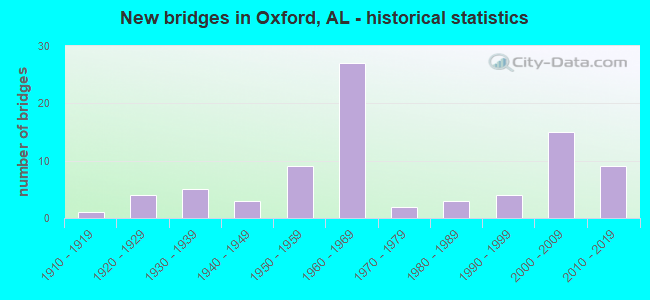
- New bridges - historical statistics
- 11910-1919
- 41920-1929
- 51930-1939
- 31940-1949
- 91950-1959
- 271960-1969
- 21970-1979
- 31980-1989
- 41990-1999
- 152000-2009
- 92010-2019

- Reconstructed bridges - Historical Statistics
- 11930-1939
- 11940-1949
- 01950-1959
- 01960-1969
- 01970-1979
- 21980-1989
- 01990-1999
- 22000-2009


- Bridge Condition - Deck
- 2.0%Excellent
- 8.2%Very good
- 36.7%Good
- 28.6%Satisfactory
- 24.5%Fair

- Bridge Condition - Superstructure
- 4.1%Excellent
- 28.6%Very good
- 14.3%Good
- 28.6%Satisfactory
- 24.5%Fair

- Bridge Condition - Substructure
- 4.1%Excellent
- 22.4%Very good
- 32.7%Good
- 24.5%Satisfactory
- 14.3%Fair
- 2.0%Poor

- Bridge Condition - Channel
- 7.7%Excellent
- 9.6%Very good
- 34.6%Good
- 34.6%Satisfactory
- 13.5%Fair

- Bridge Condition - Culverts
- 26.3%Good
- 57.9%Satisfactory
- 15.8%Fair
Find on map >> Show street view
Structure Number: 69, Location: 1.8 MI E CO58 AT SILVER R (Lat: 33.566875, Lng: -85.884739), Route carried "on" structure: County highway 128, Year Built: 1912, Year Reconstructed: 2008, Status: Posted for load, Structure Length: 0.94m (3.08ft), Average Daily Traffic: 430 (year 2018), Truck Traffic: 2%, Average Future Daily Traffic: 565 (year 2038), Design Load: H 10, Features Intersected: SILVER RUN CREEK, Facility Carried by Structure: CO. RD.044 COBB RD
Minimum Vertical Clearance: 30+ m (98+ ft), Kilometerpoint: 0.010, Lanes on structure: 2, Owner: County Highway Agency, Approaching Roadway Width: 5.5m (18.0ft), Skew: 2 degrees, Material/Design: Steel, Design/Construction: Stringer/Multi-beam, Number Of Spans In Main Unit: 1, Length of Maximum Span: 9.4m (30.8ft), Curb or Sidewalk Widths: Left: 0.2m (0.7ft), Right: 0.2m (0.7ft), Curb-To-Curb Width: 5.3m (17.4ft), Out-to-Out Width: 5.7m (18.7ft)
Condition: Deck: Satisfactory, Superstructure: Satisfactory, Substructure: Satisfactory, Channel: Good, Operating Rating: 30.7 metric tons, Method Used To Determine Operating Rating: Load Factor (LF), Inventory Rating: 18.4 metric tons, Method Used To Determine Inventory Rating: Load Factor (LF), Structural Evaluation: Somewhat better than minimum adequacy, Waterway Adequacy: Somewhat better than minimum adequacy, Approach Roadway Alignment: Meets minimum limits, Bridge Posting: Required (Relationship of Operating Rating to Maximum Legal Load: 30.0 - 39.9% below), Length Of Structure Improvement: 1.61m (5.28ft), Designated Inspection Frequency: Every 24 months, Other Special Inspection Frequency: Every 12 months, Inspection Date: August 2020, Other Special Inspection Date: August 2021, Bridge Improvement Cost: $198,000, Roadway Improvement Cost: $20,000, Total Project Cost: $218,000 ( Estimate for 2022), Deck Structure Type: Wood or Timber, Wearing Surface/Protective System: Wearing Surface: Wood or Timber
Find on map >> Show street view
Structure Number: 137, Location: 1.4 MI S OF US 280 (Lat: 32.880000, Lng: -85.805000), Route carried "on" structure: City street , Year Built: 1920, Status: Open, Structure Length: 2.44m (8.01ft), Average Daily Traffic: 1,000 (year 2021), Truck Traffic: 2%, Average Future Daily Traffic: 2,000 (year 2041), Design Load: H 15, Features Intersected: MANOY CREEK, Facility Carried by Structure: MAIN ST.
Minimum Vertical Clearance: 30+ m (98+ ft), Kilometerpoint: 1.399, Lanes on structure: 2, Owner: City or Municipal Highway Agency, Approaching Roadway Width: 6.1m (20.0ft), Material/Design: Concrete, Design/Construction: Tee Beam, Number Of Spans In Main Unit: 1, Number Of Approach Spans: 2, Length of Maximum Span: 8.1m (26.6ft), Curb or Sidewalk Widths: Left: 0.2m (0.7ft), Right: 0.2m (0.7ft), Curb-To-Curb Width: 6.2m (20.3ft), Out-to-Out Width: 7.2m (23.6ft)
Condition: Deck: Satisfactory, Superstructure: Satisfactory, Substructure: Fair, Channel: Fair, Operating Rating: 64.9 metric tons, Method Used To Determine Operating Rating: Load Factor (LF), Inventory Rating: 38.8 metric tons, Method Used To Determine Inventory Rating: Load Factor (LF), Structural Evaluation: Somewhat better than minimum adequacy, Deck Geometry: High priority of corrective action, Waterway Adequacy: Equal to present minimum criteria, Approach Roadway Alignment: Equal to present minimum criteria, Length Of Structure Improvement: 3.31m (10.86ft), Designated Inspection Frequency: Every 24 months, Inspection Date: August 2021, Bridge Improvement Cost: $522,000, Roadway Improvement Cost: $52,000, Total Project Cost: $574,000 ( Estimate for 2022), Deck Structure Type: Concrete Cast-file-Place, Wearing Surface/Protective System: Wearing Surface: Bituminous
Find on map >> Show street view
Structure Number: 573, Location: 2.5 MI W JCT I-20 (Lat: 33.618833, Lng: -85.758333), Route carried "on" structure: US 78, Year Built: 1929, Status: Open, Structure Length: 0.63m (2.07ft), Average Daily Traffic: 10,218 (year 2019), Truck Traffic: 8%, Average Future Daily Traffic: 14,025 (year 2039), Design Load: H 15, Features Intersected: BRANCH
Minimum Vertical Clearance: 30+ m (98+ ft), Kilometerpoint: 264.737, Lanes on structure: 2, Base Highway Network: Yes, Owner: State Highway Agency, Approaching Roadway Width: 8.5m (27.9ft), Material/Design: Concrete, Design/Construction: Culvert, Number Of Spans In Main Unit: 2, Length of Maximum Span: 3.0m (9.8ft)
Condition: Channel: Good, Culverts: Good, Operating Rating: 53.2 metric tons, Method Used To Determine Operating Rating: Allowable Stress (AS), Inventory Rating: 32.7 metric tons, Method Used To Determine Inventory Rating: Allowable Stress (AS), Structural Evaluation: Better than present minimum criteria, Waterway Adequacy: Equal to present minimum criteria, Approach Roadway Alignment: Equal to present desirable criteria, Length Of Structure Improvement: 1.25m (4.10ft), Designated Inspection Frequency: Every 24 months, Inspection Date: July 2021, Bridge Improvement Cost: $239,000, Roadway Improvement Cost: $24,000, Total Project Cost: $263,000 ( Estimate for 2022)
Find on map >> Show street view
Structure Number: 583, Location: 0.1 MI WEST JCT SR 202 (Lat: 33.603400, Lng: -85.998500), Route carried "on" structure: US 78, Year Built: 1929, Status: Open, Structure Length: 0.96m (3.15ft), Average Daily Traffic: 9,700 (year 2020), Truck Traffic: 7%, Average Future Daily Traffic: 13,580 (year 2040), Design Load: H 15, Features Intersected: EASTABOGA CREEK
Minimum Vertical Clearance: 30+ m (98+ ft), Kilometerpoint: 241.695, Lanes on structure: 2, Owner: State Highway Agency, Approaching Roadway Width: 8.5m (27.9ft), Material/Design: Concrete, Design/Construction: Culvert, Number Of Spans In Main Unit: 3, Length of Maximum Span: 3.1m (10.2ft)
Condition: Channel: Satisfactory, Culverts: Satisfactory, Operating Rating: 55.6 metric tons, Method Used To Determine Operating Rating: Load Factor (LF), Inventory Rating: 33.4 metric tons, Method Used To Determine Inventory Rating: Load Factor (LF), Structural Evaluation: Equal to present minimum criteria, Waterway Adequacy: Equal to present minimum criteria, Approach Roadway Alignment: Equal to present desirable criteria, Length Of Structure Improvement: 1.64m (5.38ft), Designated Inspection Frequency: Every 24 months, Inspection Date: August 2021, Bridge Improvement Cost: $302,000, Roadway Improvement Cost: $30,000, Total Project Cost: $332,000 ( Estimate for 2022)
Find on map >> Show street view
Structure Number: 695, Location: 2 MI EAST JCT US 78 (Lat: 33.612436, Lng: -85.962889), Route carried "on" structure: City street MU202, Year Built: 1929, Status: Open, Structure Length: 0.67m (2.20ft), Average Daily Traffic: 5,120 (year 2021), Truck Traffic: 5%, Average Future Daily Traffic: 8,390 (year 2041), Design Load: H 15, Features Intersected: EASTABOGA CREEK, Facility Carried by Structure: OLD SR 202
Minimum Vertical Clearance: 30+ m (98+ ft), Kilometerpoint: 3.238, Lanes on structure: 2, Owner: City or Municipal Highway Agency, Approaching Roadway Width: 19.2m (63.0ft), Material/Design: Concrete, Design/Construction: Culvert, Number Of Spans In Main Unit: 2, Length of Maximum Span: 3.0m (9.8ft)
Condition: Channel: Fair, Culverts: Satisfactory, Operating Rating: 49.6 metric tons, Method Used To Determine Operating Rating: Load Factor (LF), Inventory Rating: 29.8 metric tons, Method Used To Determine Inventory Rating: Load Factor (LF), Structural Evaluation: Equal to present minimum criteria, Waterway Adequacy: Equal to present minimum criteria, Approach Roadway Alignment: Equal to present desirable criteria, Length Of Structure Improvement: 1.30m (4.27ft), Designated Inspection Frequency: Every 24 months, Inspection Date: December 2021, Bridge Improvement Cost: $473,000, Roadway Improvement Cost: $47,000, Total Project Cost: $520,000 ( Estimate for 2022)
Find on map >> Show street view
Structure Number: 986, Location: 3.3 MI N JCT SR 35 (Lat: 34.591547, Lng: -85.918467), Route carried "on" structure: County highway 47, Year Built: 1932, Status: Open, Structure Length: 2.19m (7.19ft), Average Daily Traffic: 1,040 (year 1989), Truck Traffic: 11%, Average Future Daily Traffic: 2,270 (year 2040), Design Load: H 15, Features Intersected: KIRBY CREEK
Minimum Vertical Clearance: 30+ m (98+ ft), Kilometerpoint: 0.010, Lanes on structure: 2, Owner: County Highway Agency, Approaching Roadway Width: 7.3m (24.0ft), Skew: 4 degrees, Material/Design: Concrete, Design/Construction: Tee Beam, Number Of Spans In Main Unit: 2, Length of Maximum Span: 11.0m (36.1ft), Curb or Sidewalk Widths: Left: 0.1m (0.3ft), Right: 0.1m (0.3ft), Curb-To-Curb Width: 7.4m (24.3ft), Out-to-Out Width: 8.4m (27.6ft)
Condition: Deck: Satisfactory, Superstructure: Satisfactory, Substructure: Satisfactory, Channel: Satisfactory, Operating Rating: 43.5 metric tons, Method Used To Determine Operating Rating: Field evaluation and documented engineering judgment, Inventory Rating: 32.7 metric tons, Method Used To Determine Inventory Rating: Field evaluation and documented engineering judgment, Structural Evaluation: Equal to present minimum criteria, Deck Geometry: Meets minimum limits, Waterway Adequacy: Better than present minimum criteria, Approach Roadway Alignment: Better than present minimum criteria, Length Of Structure Improvement: 2.99m (9.81ft), Designated Inspection Frequency: Every 24 months, Inspection Date: March 2020, Bridge Improvement Cost: $554,000, Roadway Improvement Cost: $55,000, Total Project Cost: $609,000 ( Estimate for 2022), Deck Structure Type: Concrete Cast-file-Place, Wearing Surface/Protective System: Wearing Surface: Other
Find on map >> Show street view
Structure Number: 137, Location: Cecile Dr/.1 mi N US78 (Lat: 33.596858, Lng: -85.923350), Route carried "on" structure: City street , Year Built: 1936, Status: Posted for load, Structure Length: 1.83m (6.00ft), Average Daily Traffic: 525 (year 2021), Truck Traffic: 1%, Average Future Daily Traffic: 625 (year 2041), Features Intersected: COLDWATER CREEK, Facility Carried by Structure: CECILE DRIVE
Minimum Vertical Clearance: 30+ m (98+ ft), Kilometerpoint: 0.161, Lanes on structure: 1, Owner: City or Municipal Highway Agency, Approaching Roadway Width: 4.9m (16.1ft), Material/Design: Steel, Design/Construction: Stringer/Multi-beam, Number Of Spans In Main Unit: 2, Length of Maximum Span: 9.1m (29.9ft), Curb-To-Curb Width: 3.7m (12.1ft), Out-to-Out Width: 3.7m (12.1ft)
Condition: Deck: Fair, Superstructure: Fair, Substructure: Satisfactory, Channel: Satisfactory, Operating Rating: 2.7 metric tons, Method Used To Determine Operating Rating: Load Factor (LF), Inventory Rating: 1.8 metric tons, Method Used To Determine Inventory Rating: Load Factor (LF), Structural Evaluation: High priority of replacement, Deck Geometry: High priority of replacement, Waterway Adequacy: Somewhat better than minimum adequacy, Approach Roadway Alignment: Meets minimum limits, Bridge Posting: Required (Relationship of Operating Rating to Maximum Legal Load: > 39.9% below), Length Of Structure Improvement: 2.54m (8.33ft), Designated Inspection Frequency: Every 24 months, Other Special Inspection Frequency: Every 12 months, Inspection Date: December 2020, Other Special Inspection Date: December 2021, Bridge Improvement Cost: $209,000, Roadway Improvement Cost: $21,000, Total Project Cost: $230,000 ( Estimate for 2022), Deck Structure Type: Concrete Cast-file-Place
Find on map >> Show street view
Structure Number: 1795, Location: 2.3 M N JCT SR 67 & SR 36 (Lat: 34.466656, Lng: -86.788547), Route carried "on" structure: State highway 67, Year Built: 1938, Status: Open, Structure Length: 4.15m (13.62ft), Average Daily Traffic: 5,600 (year 2021), Truck Traffic: 15%, Average Future Daily Traffic: 7,265 (year 2033), Design Load: H 15, Features Intersected: TOWN CREEK
Minimum Vertical Clearance: 30+ m (98+ ft), Kilometerpoint: 42.500, Lanes on structure: 2, Base Highway Network: Yes, Owner: State Highway Agency, Approaching Roadway Width: 7.6m (24.9ft), Material/Design: Concrete, Design/Construction: Tee Beam, Number Of Spans In Main Unit: 4, Length of Maximum Span: 10.4m (34.1ft), Curb or Sidewalk Widths: Left: 0.2m (0.7ft), Right: 0.2m (0.7ft), Curb-To-Curb Width: 7.3m (24.0ft), Out-to-Out Width: 8.4m (27.6ft)
Condition: Deck: Fair, Superstructure: Fair, Substructure: Fair, Channel: Fair, Operating Rating: 40.6 metric tons, Method Used To Determine Operating Rating: Load Factor (LF), Inventory Rating: 24.3 metric tons, Method Used To Determine Inventory Rating: Load Factor (LF), Structural Evaluation: Somewhat better than minimum adequacy, Deck Geometry: High priority of replacement, Waterway Adequacy: Somewhat better than minimum adequacy, Approach Roadway Alignment: Better than present minimum criteria, Length Of Structure Improvement: 5.11m (16.77ft), Designated Inspection Frequency: Every 24 months, Inspection Date: October 2021, Bridge Improvement Cost: $946,000, Roadway Improvement Cost: $95,000, Total Project Cost: $1,041,000 ( Estimate for 2022), Deck Structure Type: Concrete Cast-file-Place, Wearing Surface/Protective System: Wearing Surface: Bituminous
Find on map >> Show street view
Structure Number: 1812, Location: 1823 FT N JCT 1092 (Lat: 34.164458, Lng: -86.281394), Route carried "on" structure: County highway 93, Year Built: 1970, Status: Posted for load, Structure Length: 1.37m (4.49ft), Average Daily Traffic: 75 (year 1994), Average Future Daily Traffic: 125 (year 2040), Design Load: H 15, Features Intersected: BIG MUD CREEK, Facility Carried by Structure: COUNTY HIGHWAY109
Minimum Vertical Clearance: 30+ m (98+ ft), Kilometerpoint: 0.010, Lanes on structure: 2, Owner: County Highway Agency, Approaching Roadway Width: 7.9m (25.9ft), Material/Design: Concrete, Design/Construction: Channel Beam, Number Of Spans In Main Unit: 3, Length of Maximum Span: 4.6m (15.1ft), Curb-To-Curb Width: 6.6m (21.7ft), Out-to-Out Width: 7.3m (24.0ft)
Condition: Deck: Satisfactory, Superstructure: Fair, Substructure: Good, Channel: Good, Operating Rating: 28.1 metric tons, Method Used To Determine Operating Rating: Load Factor (LF), Inventory Rating: 16.9 metric tons, Method Used To Determine Inventory Rating: Load Factor (LF), Structural Evaluation: Somewhat better than minimum adequacy, Deck Geometry: Somewhat better than minimum adequacy, Waterway Adequacy: Equal to present desirable criteria, Approach Roadway Alignment: Equal to present minimum criteria, Bridge Posting: Required (Relationship of Operating Rating to Maximum Legal Load: 30.0 - 39.9% below), Length Of Structure Improvement: 2.04m (6.69ft), Designated Inspection Frequency: Every 24 months, Other Special Inspection Frequency: Every 12 months, Inspection Date: August 2020, Other Special Inspection Date: August 2021, Bridge Improvement Cost: $336,000, Roadway Improvement Cost: $34,000, Total Project Cost: $370,000 ( Estimate for 2022), Deck Structure Type: Concrete Precast Panels
Find on map >> Show street view
Structure Number: 2634, Location: 0.9 MI N JCT CO 96 (Lat: 33.503333, Lng: -86.004722), Route carried "on" structure: State highway 21, Year Built: 1933, Year Reconstructed: 1942, Status: Open, Structure Length: 8.78m (28.81ft), Average Daily Traffic: 11,265 (year 2019), Truck Traffic: 7%, Average Future Daily Traffic: 15,771 (year 2039), Design Load: H 15, Features Intersected: CHEAHA CREEK
Minimum Vertical Clearance: 30+ m (98+ ft), Kilometerpoint: 383.257, Lanes on structure: 2, Base Highway Network: Yes, Owner: State Highway Agency, Approaching Roadway Width: 8.5m (27.9ft), Material/Design: Concrete, Design/Construction: Tee Beam, Number Of Spans In Main Unit: 10, Length of Maximum Span: 15.2m (49.9ft), Curb or Sidewalk Widths: Left: 0.1m (0.3ft), Right: 0.1m (0.3ft), Curb-To-Curb Width: 7.3m (24.0ft), Out-to-Out Width: 7.6m (24.9ft)
Condition: Deck: Fair, Superstructure: Fair, Substructure: Fair, Channel: Fair, Operating Rating: 52.6 metric tons, Method Used To Determine Operating Rating: Load Factor (LF), Inventory Rating: 31.6 metric tons, Method Used To Determine Inventory Rating: Load Factor (LF), Structural Evaluation: Somewhat better than minimum adequacy, Deck Geometry: High priority of replacement, Waterway Adequacy: Equal to present desirable criteria, Approach Roadway Alignment: Somewhat better than minimum adequacy, Length Of Structure Improvement: 9.76m (32.02ft), Designated Inspection Frequency: Every 24 months, Inspection Date: December 2021, Bridge Improvement Cost: $1,606,000, Roadway Improvement Cost: $161,000, Total Project Cost: $1,767,000 ( Estimate for 2022), Deck Structure Type: Concrete Cast-file-Place
Find on map >> Show street view
Structure Number: 2685, Location: 2.5 MI S OF OXFORD (Lat: 33.565444, Lng: -85.862194), Route carried "on" structure: State highway 21, Year Built: 1942, Status: Open, Structure Length: 2.71m (8.89ft), Average Daily Traffic: 5,698 (year 2019), Truck Traffic: 6%, Average Future Daily Traffic: 7,977 (year 2039), Design Load: H 15, Features Intersected: DRY CREEK
Minimum Vertical Clearance: 30+ m (98+ ft), Kilometerpoint: 398.311, Lanes on structure: 2, Base Highway Network: Yes, Owner: State Highway Agency, Approaching Roadway Width: 10.4m (34.1ft), Material/Design: Steel, Design/Construction: Stringer/Multi-beam, Number Of Spans In Main Unit: 4, Length of Maximum Span: 6.7m (22.0ft), Curb or Sidewalk Widths: Left: 0.5m (1.6ft), Right: 0.5m (1.6ft), Curb-To-Curb Width: 7.3m (24.0ft), Out-to-Out Width: 8.2m (26.9ft)
Condition: Deck: Fair, Superstructure: Satisfactory, Substructure: Satisfactory, Channel: Satisfactory, Operating Rating: 60.6 metric tons, Method Used To Determine Operating Rating: Load Factor (LF), Inventory Rating: 36.3 metric tons, Method Used To Determine Inventory Rating: Load Factor (LF), Structural Evaluation: Equal to present minimum criteria, Deck Geometry: High priority of replacement, Waterway Adequacy: Equal to present minimum criteria, Approach Roadway Alignment: Equal to present desirable criteria, Length Of Structure Improvement: 3.63m (11.91ft), Designated Inspection Frequency: Every 24 months, Inspection Date: Febuary 2022, Bridge Improvement Cost: $647,000, Roadway Improvement Cost: $65,000, Total Project Cost: $712,000 ( Estimate for 2022), Deck Structure Type: Concrete Cast-file-Place
Find on map >> Show street view
Structure Number: 2984, Location: 7.5 MI W JCT SR 9 (Lat: 33.604567, Lng: -85.717478), Route carried "on" structure: US 431, Year Built: 1930, Year Reconstructed: 1947, Status: Open, Structure Length: 0.63m (2.07ft), Average Daily Traffic: 6,673 (year 2019), Truck Traffic: 8%, Average Future Daily Traffic: 9,342 (year 2039), Design Load: H 15, Features Intersected: JACKSON CREEK
Minimum Vertical Clearance: 30+ m (98+ ft), Kilometerpoint: 354.534, Lanes on structure: 2, Base Highway Network: Yes, Owner: State Highway Agency, Approaching Roadway Width: 8.5m (27.9ft), Material/Design: Concrete, Design/Construction: Culvert, Number Of Spans In Main Unit: 2, Length of Maximum Span: 3.0m (9.8ft)
Condition: Channel: Good, Culverts: Satisfactory, Operating Rating: 88.9 metric tons, Method Used To Determine Operating Rating: Load Factor (LF), Inventory Rating: 77.9 metric tons, Method Used To Determine Inventory Rating: Load Factor (LF), Structural Evaluation: Equal to present minimum criteria, Waterway Adequacy: Equal to present minimum criteria, Approach Roadway Alignment: Equal to present desirable criteria, Length Of Structure Improvement: 1.25m (4.10ft), Designated Inspection Frequency: Every 24 months, Inspection Date: May 2021, Bridge Improvement Cost: $348,000, Roadway Improvement Cost: $35,000, Total Project Cost: $383,000 ( Estimate for 2022)
Find on map >> Show street view
Structure Number: 3004, Location: 8 MI W JCT SR 9 (Lat: 33.610469, Lng: -85.722831), Route carried "on" structure: US 431, Year Built: 1947, Status: Open, Structure Length: 1.01m (3.31ft), Average Daily Traffic: 7,088 (year 2019), Truck Traffic: 13%, Average Future Daily Traffic: 9,811 (year 2039), Design Load: H 15, Features Intersected: JACKSON CREEK
Minimum Vertical Clearance: 30+ m (98+ ft), Kilometerpoint: 355.395, Lanes on structure: 2, Base Highway Network: Yes, Owner: State Highway Agency, Approaching Roadway Width: 8.5m (27.9ft), Skew: 4 degrees, Material/Design: Concrete, Design/Construction: Culvert, Number Of Spans In Main Unit: 2, Length of Maximum Span: 4.3m (14.1ft)
Condition: Channel: Satisfactory, Culverts: Satisfactory, Operating Rating: 88.9 metric tons, Method Used To Determine Operating Rating: Load Factor (LF), Inventory Rating: 88.9 metric tons, Method Used To Determine Inventory Rating: Load Factor (LF), Structural Evaluation: Equal to present minimum criteria, Waterway Adequacy: Equal to present desirable criteria, Approach Roadway Alignment: Meets minimum limits, Length Of Structure Improvement: 1.68m (5.51ft), Designated Inspection Frequency: Every 24 months, Underwater Inspection Frequency: Every 24 months, Inspection Date: October 2020, Underwater Inspection Date: October 2020, Bridge Improvement Cost: $1,058,000, Roadway Improvement Cost: $106,000, Total Project Cost: $1,164,000 ( Estimate for 2022)
Find on map >> Show street view
Structure Number: 4275, Location: .1 MI EAST JCT OLD SR 202 (Lat: 33.603200, Lng: -85.993500), Route carried "on" structure: US 78, Year Built: 1952, Status: Open, Structure Length: 2.63m (8.63ft), Average Daily Traffic: 4,757 (year 2020), Truck Traffic: 8%, Average Future Daily Traffic: 6,659 (year 2040), Design Load: H 15, Features Intersected: BRANCH
Minimum Vertical Clearance: 30+ m (98+ ft), Kilometerpoint: 242.192, Lanes on structure: 3, Base Highway Network: Yes, Owner: State Highway Agency, Approaching Roadway Width: 16.2m (53.1ft), Skew: 3 degrees, Material/Design: Concrete, Design/Construction: Culvert, Number Of Spans In Main Unit: 6, Length of Maximum Span: 4.3m (14.1ft)
Condition: Channel: Satisfactory, Culverts: Fair, Operating Rating: 49.0 metric tons, Method Used To Determine Operating Rating: Load Factor (LF), Inventory Rating: 29.4 metric tons, Method Used To Determine Inventory Rating: Load Factor (LF), Structural Evaluation: Somewhat better than minimum adequacy, Waterway Adequacy: Equal to present minimum criteria, Approach Roadway Alignment: Better than present minimum criteria, Length Of Structure Improvement: 3.53m (11.58ft), Designated Inspection Frequency: Every 24 months, Inspection Date: August 2021, Bridge Improvement Cost: $1,551,000, Roadway Improvement Cost: $155,000, Total Project Cost: $1,706,000 ( Estimate for 2022)
Find on map >> Show street view
Structure Number: 4276, Location: 4.2 MI EAST JCT SR 202 (Lat: 33.596278, Lng: -85.923500), Route carried "on" structure: US 78, Year Built: 1952, Status: Open, Structure Length: 5.18m (16.99ft), Average Daily Traffic: 10,314 (year 2020), Truck Traffic: 7%, Average Future Daily Traffic: 14,440 (year 2040), Design Load: HS 20, Features Intersected: COLDWATER CREEK
Minimum Vertical Clearance: 30+ m (98+ ft), Kilometerpoint: 248.817, Lanes on structure: 2, Owner: State Highway Agency, Approaching Roadway Width: 13.7m (44.9ft), Material/Design: Concrete, Design/Construction: Tee Beam, Number Of Spans In Main Unit: 5, Length of Maximum Span: 10.4m (34.1ft), Curb or Sidewalk Widths: Left: 0.5m (1.6ft), Right: 0.5m (1.6ft), Curb-To-Curb Width: 9.1m (29.9ft), Out-to-Out Width: 10.3m (33.8ft)
Condition: Deck: Satisfactory, Superstructure: Satisfactory, Substructure: Satisfactory, Channel: Good, Operating Rating: 43.3 metric tons, Method Used To Determine Operating Rating: Load Factor (LF), Inventory Rating: 25.9 metric tons, Method Used To Determine Inventory Rating: Load Factor (LF), Structural Evaluation: Equal to present minimum criteria, Deck Geometry: High priority of corrective action, Waterway Adequacy: Equal to present minimum criteria, Approach Roadway Alignment: Equal to present desirable criteria, Length Of Structure Improvement: 6.20m (20.34ft), Designated Inspection Frequency: Every 24 months, Inspection Date: August 2021, Bridge Improvement Cost: $1,403,000, Roadway Improvement Cost: $140,000, Total Project Cost: $1,543,000 ( Estimate for 2022), Deck Structure Type: Concrete Cast-file-Place
Find on map >> Show street view
Structure Number: 4772, Location: Fship Rd /.5 MI E AL 21 (Lat: 33.870000, Lng: -85.758333), Route carried "on" structure: City street , Year Built: 1954, Status: Open, Structure Length: 4.15m (13.62ft), Average Daily Traffic: 11,500 (year 2020), Truck Traffic: 10%, Average Future Daily Traffic: 17,089 (year 2040), Design Load: H 15, Features Intersected: CHOCCOLOCCO CREEK, Facility Carried by Structure: FRIENDSHIP RD
Minimum Vertical Clearance: 30+ m (98+ ft), Kilometerpoint: 0.499, Lanes on structure: 2, Owner: City or Municipal Highway Agency, Approaching Roadway Width: 9.1m (29.9ft), Material/Design: Concrete, Design/Construction: Tee Beam, Number Of Spans In Main Unit: 4, Length of Maximum Span: 10.4m (34.1ft), Curb or Sidewalk Widths: Left: 0.5m (1.6ft), Right: 0.5m (1.6ft), Curb-To-Curb Width: 7.2m (23.6ft), Out-to-Out Width: 8.4m (27.6ft)
Condition: Deck: Satisfactory, Superstructure: Satisfactory, Substructure: Fair, Channel: Fair, Operating Rating: 35.7 metric tons, Method Used To Determine Operating Rating: Load Factor (LF), Inventory Rating: 21.5 metric tons, Method Used To Determine Inventory Rating: Load Factor (LF), Structural Evaluation: Somewhat better than minimum adequacy, Deck Geometry: High priority of replacement, Waterway Adequacy: Equal to present minimum criteria, Approach Roadway Alignment: Equal to present desirable criteria, Length Of Structure Improvement: 5.11m (16.77ft), Designated Inspection Frequency: Every 24 months, Inspection Date: December 2020, Bridge Improvement Cost: $946,000, Roadway Improvement Cost: $95,000, Total Project Cost: $1,041,000 ( Estimate for 2022), Deck Structure Type: Concrete Cast-file-Place
Find on map >> Show street view
Structure Number: 4773, Location: Fship Rd/.7 MI E AL 21 (Lat: 33.598333, Lng: -85.823333), Route carried "on" structure: City street , Year Built: 1954, Status: Open, Structure Length: 6.22m (20.41ft), Average Daily Traffic: 11,500 (year 2020), Truck Traffic: 10%, Average Future Daily Traffic: 17,089 (year 2040), Design Load: H 15, Features Intersected: CHOCCOLOCCO CREEK RELIEF, Facility Carried by Structure: FRIENDSHIP RD
Minimum Vertical Clearance: 30+ m (98+ ft), Kilometerpoint: 0.698, Lanes on structure: 2, Owner: City or Municipal Highway Agency, Approaching Roadway Width: 7.3m (24.0ft), Material/Design: Concrete, Design/Construction: Tee Beam, Number Of Spans In Main Unit: 6, Length of Maximum Span: 10.4m (34.1ft), Curb or Sidewalk Widths: Left: 0.5m (1.6ft), Right: 0.5m (1.6ft), Curb-To-Curb Width: 7.2m (23.6ft), Out-to-Out Width: 8.4m (27.6ft)
Condition: Deck: Good, Superstructure: Good, Substructure: Satisfactory, Channel: Satisfactory, Operating Rating: 35.7 metric tons, Method Used To Determine Operating Rating: Load Factor (LF), Inventory Rating: 21.5 metric tons, Method Used To Determine Inventory Rating: Load Factor (LF), Structural Evaluation: Somewhat better than minimum adequacy, Deck Geometry: High priority of replacement, Waterway Adequacy: Equal to present minimum criteria, Approach Roadway Alignment: Equal to present desirable criteria, Length Of Structure Improvement: 7.26m (23.82ft), Designated Inspection Frequency: Every 24 months, Inspection Date: December 2020, Bridge Improvement Cost: $1,344,000, Roadway Improvement Cost: $134,000, Total Project Cost: $1,478,000 ( Estimate for 2022), Deck Structure Type: Concrete Cast-file-Place
Find on map >> Show street view
Structure Number: 4774, Location: Fship Rd/.9 MI E AL 21 (Lat: 33.596667, Lng: -85.821667), Route carried "on" structure: City street , Year Built: 1954, Status: Open, Structure Length: 5.18m (16.99ft), Average Daily Traffic: 11,500 (year 2018), Truck Traffic: 10%, Average Future Daily Traffic: 17,089 (year 2038), Design Load: H 15, Features Intersected: CHOCCOLOCCO CREEK RELIEF, Facility Carried by Structure: FRIENDSHIP RD
Minimum Vertical Clearance: 30+ m (98+ ft), Kilometerpoint: 0.900, Lanes on structure: 2, Owner: City or Municipal Highway Agency, Approaching Roadway Width: 9.1m (29.9ft), Material/Design: Concrete, Design/Construction: Tee Beam, Number Of Spans In Main Unit: 5, Length of Maximum Span: 10.4m (34.1ft), Curb or Sidewalk Widths: Left: 0.5m (1.6ft), Right: 0.5m (1.6ft), Curb-To-Curb Width: 7.2m (23.6ft), Out-to-Out Width: 8.4m (27.6ft)
Condition: Deck: Satisfactory, Superstructure: Satisfactory, Substructure: Good, Channel: Good, Operating Rating: 35.7 metric tons, Method Used To Determine Operating Rating: Load Factor (LF), Inventory Rating: 21.5 metric tons, Method Used To Determine Inventory Rating: Load Factor (LF), Structural Evaluation: Somewhat better than minimum adequacy, Deck Geometry: High priority of replacement, Waterway Adequacy: Equal to present minimum criteria, Approach Roadway Alignment: Equal to present desirable criteria, Length Of Structure Improvement: 6.21m (20.37ft), Designated Inspection Frequency: Every 24 months, Inspection Date: December 2020, Bridge Improvement Cost: $1,149,000, Roadway Improvement Cost: $115,000, Total Project Cost: $1,264,000 ( Estimate for 2022), Deck Structure Type: Concrete Cast-file-Place
Find on map >> Show street view
Structure Number: 5314, Location: 1 MI S STATE 21 AT ANTIOC (Lat: 33.560000, Lng: -85.851667), Route carried "on" structure: County highway 135, Year Built: 1955, Status: Open, Structure Length: 1.31m (4.30ft), Average Daily Traffic: 1,475 (year 2018), Truck Traffic: 10%, Average Future Daily Traffic: 2,020 (year 2038), Design Load: H 20, Features Intersected: DRY BRCH TO CHOCCOLOCCO
Minimum Vertical Clearance: 30+ m (98+ ft), Kilometerpoint: 0.010, Lanes on structure: 2, Owner: County Highway Agency, Approaching Roadway Width: 8.5m (27.9ft), Material/Design: Concrete, Design/Construction: Culvert, Number Of Spans In Main Unit: 4, Length of Maximum Span: 3.0m (9.8ft), Curb or Sidewalk Widths: Left: 0.2m (0.7ft), Right: 0.2m (0.7ft)
Condition: Channel: Good, Culverts: Good, Operating Rating: 37.2 metric tons, Method Used To Determine Operating Rating: Load Factor (LF), Inventory Rating: 22.3 metric tons, Method Used To Determine Inventory Rating: Load Factor (LF), Structural Evaluation: Somewhat better than minimum adequacy, Waterway Adequacy: Better than present minimum criteria, Approach Roadway Alignment: Better than present minimum criteria, Length Of Structure Improvement: 1.98m (6.50ft), Designated Inspection Frequency: Every 24 months, Inspection Date: May 2020, Bridge Improvement Cost: $378,000, Roadway Improvement Cost: $38,000, Total Project Cost: $416,000 ( Estimate for 2022), Wearing Surface/Protective System: Wearing Surface: Bituminous
Find on map >> Show street view
Structure Number: 5756, Location: 0.6 MI NO JCT US 78 (Lat: 33.619353, Lng: -85.828300), Route carried "on" structure: State highway 21, Year Built: 1957, Status: Open, Structure Length: 15.58m (51.12ft), Average Daily Traffic: 14,940 (year 2019), Truck Traffic: 6%, Average Future Daily Traffic: 20,916 (year 2039), Design Load: HS 20, Features Intersected: N.SOUTH. RR/SNOW CREEK
Minimum Vertical Clearance: 30+ m (98+ ft), Kilometerpoint: 404.476, Lanes on structure: 2, Base Highway Network: Yes, Owner: State Highway Agency, Approaching Roadway Width: 8.5m (27.9ft), Skew: 10 degrees, Material/Design: Steel continuous, Design/Construction: Stringer/Multi-beam, Number Of Spans In Main Unit: 8, Length of Maximum Span: 30.5m (100.1ft), Curb or Sidewalk Widths: Left: 1.3m (4.3ft), Right: 0.5m (1.6ft), Curb-To-Curb Width: 8.5m (27.9ft), Out-to-Out Width: 10.4m (34.1ft)
Condition: Deck: Fair, Superstructure: Fair, Substructure: Fair, Channel: Satisfactory, Operating Rating: 57.7 metric tons, Method Used To Determine Operating Rating: Load Factor (LF), Inventory Rating: 34.6 metric tons, Method Used To Determine Inventory Rating: Load Factor (LF), Structural Evaluation: Somewhat better than minimum adequacy, Deck Geometry: High priority of corrective action, Underclear: Meets minimum limits, Waterway Adequacy: Equal to present minimum criteria, Approach Roadway Alignment: Equal to present desirable criteria, Length Of Structure Improvement: 16.35m (53.64ft), Designated Inspection Frequency: Every 24 months, Inspection Date: April 2020, Bridge Improvement Cost: $3,811,000, Roadway Improvement Cost: $381,000, Total Project Cost: $4,192,000 ( Estimate for 2022), Deck Structure Type: Concrete Cast-file-Place, Wearing Surface/Protective System: Wearing Surface: Bituminous
Find on map >> Show street view
Structure Number: 5757, Location: 0.6 MI NO JCT US 78 (Lat: 33.618889, Lng: -85.828028), Route carried "on" structure: State highway 21, Year Built: 1957, Status: Open, Structure Length: 17.11m (56.14ft), Average Daily Traffic: 14,940 (year 2019), Truck Traffic: 6%, Average Future Daily Traffic: 20,916 (year 2039), Design Load: HS 20, Features Intersected: N.SOUTH RR/SNOW CREEK
Minimum Vertical Clearance: 30+ m (98+ ft), Kilometerpoint: 404.428, Lanes on structure: 2, Base Highway Network: Yes, Owner: State Highway Agency, Approaching Roadway Width: 8.5m (27.9ft), Skew: 10 degrees, Material/Design: Steel continuous, Design/Construction: Stringer/Multi-beam, Number Of Spans In Main Unit: 9, Length of Maximum Span: 30.5m (100.1ft), Curb or Sidewalk Widths: Left: 0.5m (1.6ft), Right: 1.3m (4.3ft), Curb-To-Curb Width: 8.5m (27.9ft), Out-to-Out Width: 10.4m (34.1ft)
Condition: Deck: Fair, Superstructure: Fair, Substructure: Satisfactory, Channel: Satisfactory, Operating Rating: 55.7 metric tons, Method Used To Determine Operating Rating: Load Factor (LF), Inventory Rating: 33.4 metric tons, Method Used To Determine Inventory Rating: Load Factor (LF), Structural Evaluation: Somewhat better than minimum adequacy, Deck Geometry: High priority of corrective action, Underclear: Meets minimum limits, Waterway Adequacy: Equal to present minimum criteria, Approach Roadway Alignment: Equal to present desirable criteria, Length Of Structure Improvement: 17.83m (58.50ft), Designated Inspection Frequency: Every 24 months, Inspection Date: April 2020, Bridge Improvement Cost: $4,156,000, Roadway Improvement Cost: $416,000, Total Project Cost: $4,572,000 ( Estimate for 2022), Deck Structure Type: Concrete Cast-file-Place, Wearing Surface/Protective System: Wearing Surface: Bituminous
Find on map >> Show street view
Structure Number: 5958, Location: 0.5 MI S I20 (Lat: 33.582214, Lng: -85.905661), Route carried "on" structure: County highway 58, Year Built: 1957, Status: Posted for load, Structure Length: 3.05m (10.01ft), Average Daily Traffic: 173 (year 2018), Average Future Daily Traffic: 230 (year 2038), Features Intersected: CHOCCOLOCCO CREEK
Minimum Vertical Clearance: 30+ m (98+ ft), Kilometerpoint: 0.010, Lanes on structure: 1, Owner: County Highway Agency, Approaching Roadway Width: 6.7m (22.0ft), Material/Design: Steel, Design/Construction: Stringer/Multi-beam, Number Of Spans In Main Unit: 2, Length of Maximum Span: 15.2m (49.9ft), Curb-To-Curb Width: 4.6m (15.1ft), Out-to-Out Width: 4.6m (15.1ft)
Condition: Deck: Satisfactory, Superstructure: Fair, Substructure: Fair, Channel: Fair, Operating Rating: 36.9 metric tons, Method Used To Determine Operating Rating: Allowable Stress (AS), Inventory Rating: 26.3 metric tons, Method Used To Determine Inventory Rating: Allowable Stress (AS), Structural Evaluation: Somewhat better than minimum adequacy, Deck Geometry: High priority of replacement, Waterway Adequacy: High priority of corrective action, Approach Roadway Alignment: Meets minimum limits, Bridge Posting: Required (Relationship of Operating Rating to Maximum Legal Load: 0.1 - 9.9% below), Length Of Structure Improvement: 3.90m (12.80ft), Designated Inspection Frequency: Every 24 months, Other Special Inspection Frequency: Every 12 months, Inspection Date: June 2020, Other Special Inspection Date: June 2021, Bridge Improvement Cost: $401,000, Roadway Improvement Cost: $40,000, Total Project Cost: $441,000 ( Estimate for 2022), Deck Structure Type: Wood or Timber, Wearing Surface/Protective System: Wearing Surface: Wood or Timber
Find on map >> Show street view
Structure Number: 7924, Location: 1.9 MI E AL 21 (Lat: 33.593333, Lng: -85.815000), Route carried "on" structure: City street , Year Built: 1963, Status: Open, Structure Length: 0.67m (2.20ft), Average Daily Traffic: 12,000 (year 2021), Truck Traffic: 10%, Average Future Daily Traffic: 18,000 (year 2041), Design Load: H 15, Features Intersected: BRANCH, Facility Carried by Structure: FRIENDSHIP RD.
Minimum Vertical Clearance: 30+ m (98+ ft), Kilometerpoint: 1.899, Lanes on structure: 2, Owner: City or Municipal Highway Agency, Approaching Roadway Width: 7.3m (24.0ft), Skew: 4 degrees, Material/Design: Concrete, Design/Construction: Culvert, Number Of Spans In Main Unit: 2, Length of Maximum Span: 3.0m (9.8ft)
Condition: Channel: Satisfactory, Culverts: Satisfactory, Operating Rating: 60.2 metric tons, Method Used To Determine Operating Rating: Load Factor (LF), Inventory Rating: 36.2 metric tons, Method Used To Determine Inventory Rating: Load Factor (LF), Structural Evaluation: Equal to present minimum criteria, Waterway Adequacy: Better than present minimum criteria, Approach Roadway Alignment: Equal to present desirable criteria, Length Of Structure Improvement: 1.30m (4.27ft), Designated Inspection Frequency: Every 24 months, Inspection Date: April 2021, Bridge Improvement Cost: $383,000, Roadway Improvement Cost: $38,000, Total Project Cost: $421,000 ( Estimate for 2022)
Find on map >> Show street view
Structure Number: 8546, Location: EXIT 173 (EASTABOGA) (Lat: 33.581322, Lng: -86.023775), Route carried "on" structure: County highway 93, Year Built: 1965, Status: Open, Structure Length: 8.11m (26.61ft), Average Daily Traffic: 3,288 (year 2019), Truck Traffic: 10%, Average Future Daily Traffic: 4,603 (year 2039), Design Load: HS 20, Features Intersected: I-20
Minimum Vertical Clearance: 30+ m (98+ ft), Kilometerpoint: 173.989, Lanes on structure: 2, Lanes under structure: 6, Owner: State Highway Agency, Approaching Roadway Width: 11.0m (36.1ft), Skew: 2 degrees, Material/Design: Concrete continuous, Design/Construction: Tee Beam, Number Of Spans In Main Unit: 4, Length of Maximum Span: 22.3m (73.2ft), Curb or Sidewalk Widths: Left: 0.4m (1.3ft), Right: 0.4m (1.3ft), Curb-To-Curb Width: 7.3m (24.0ft), Out-to-Out Width: 8.2m (26.9ft)
Condition: Deck: Fair, Superstructure: Satisfactory, Substructure: Satisfactory, Operating Rating: 42.5 metric tons, Method Used To Determine Operating Rating: Load Factor (LF), Inventory Rating: 25.5 metric tons, Method Used To Determine Inventory Rating: Load Factor (LF), Structural Evaluation: Equal to present minimum criteria, Deck Geometry: High priority of replacement, Underclear: Somewhat better than minimum adequacy, Approach Roadway Alignment: Better than present minimum criteria, Length Of Structure Improvement: 9.11m (29.89ft), Designated Inspection Frequency: Every 24 months, Inspection Date: July 2021, Bridge Improvement Cost: $1,625,000, Roadway Improvement Cost: $163,000, Total Project Cost: $1,788,000 ( Estimate for 2022), Deck Structure Type: Concrete Cast-file-Place
Find on map >> Show street view
Structure Number: 8547, Location: 4.5 MI E EXT 173 (Lat: 33.580158, Lng: -85.948031), Route carried "on" structure: County highway 129, Year Built: 1965, Status: Open, Structure Length: 7.53m (24.70ft), Average Daily Traffic: 421 (year 2019), Truck Traffic: 4%, Average Future Daily Traffic: 589 (year 2039), Design Load: HS 20, Features Intersected: I-20
Minimum Vertical Clearance: 30+ m (98+ ft), Kilometerpoint: 178.459, Lanes on structure: 2, Lanes under structure: 6, Owner: State Highway Agency, Approaching Roadway Width: 9.8m (32.2ft), Material/Design: Concrete continuous, Design/Construction: Tee Beam, Number Of Spans In Main Unit: 4, Length of Maximum Span: 20.7m (67.9ft), Curb or Sidewalk Widths: Left: 0.4m (1.3ft), Right: 0.4m (1.3ft), Curb-To-Curb Width: 7.3m (24.0ft), Out-to-Out Width: 8.2m (26.9ft)
Condition: Deck: Satisfactory, Superstructure: Satisfactory, Substructure: Good, Operating Rating: 39.8 metric tons, Method Used To Determine Operating Rating: Load Factor (LF), Inventory Rating: 25.8 metric tons, Method Used To Determine Inventory Rating: Load Factor (LF), Structural Evaluation: Equal to present minimum criteria, Deck Geometry: Meets minimum limits, Underclear: Equal to present minimum criteria, Approach Roadway Alignment: Equal to present desirable criteria, Length Of Structure Improvement: 8.55m (28.05ft), Designated Inspection Frequency: Every 24 months, Inspection Date: July 2021, Bridge Improvement Cost: $1,524,000, Roadway Improvement Cost: $152,000, Total Project Cost: $1,676,000 ( Estimate for 2022), Deck Structure Type: Concrete Cast-file-Place
Find on map >> Show street view
Structure Number: 9222, Location: 2.3 MI W JCT SR 21 (Lat: 33.590125, Lng: -85.865617), Route carried "on" structure: County highway 109, Year Built: 1967, Status: Open, Structure Length: 10.67m (35.01ft), Average Daily Traffic: 2,971 (year 2018), Truck Traffic: 4%, Average Future Daily Traffic: 4,159 (year 2038), Design Load: HS 20, Features Intersected: I-20
Minimum Vertical Clearance: 30+ m (98+ ft), Kilometerpoint: 183.219, Lanes on structure: 2, Lanes under structure: 6, Owner: State Highway Agency, Approaching Roadway Width: 6.7m (22.0ft), Skew: 4 degrees, Material/Design: Concrete continuous, Design/Construction: Tee Beam, Number Of Spans In Main Unit: 4, Length of Maximum Span: 29.3m (96.1ft), Curb or Sidewalk Widths: Left: 0.4m (1.3ft), Right: 0.4m (1.3ft), Curb-To-Curb Width: 7.3m (24.0ft), Out-to-Out Width: 8.2m (26.9ft)
Condition: Deck: Satisfactory, Superstructure: Good, Substructure: Good, Operating Rating: 54.1 metric tons, Method Used To Determine Operating Rating: Load Factor (LF), Inventory Rating: 32.4 metric tons, Method Used To Determine Inventory Rating: Load Factor (LF), Structural Evaluation: Better than present minimum criteria, Deck Geometry: High priority of replacement, Underclear: Equal to present minimum criteria, Approach Roadway Alignment: Better than present minimum criteria, Length Of Structure Improvement: 11.57m (37.96ft), Designated Inspection Frequency: Every 24 months, Inspection Date: November 2021, Bridge Improvement Cost: $2,063,000, Roadway Improvement Cost: $206,000, Total Project Cost: $2,269,000 ( Estimate for 2022), Deck Structure Type: Concrete Cast-file-Place
Find on map >> Show street view
Structure Number: 9231, Location: EXIT 179-PRIEBES MILL (Lat: 33.583617, Lng: -85.925847), Route carried "on" structure: County highway 47, Year Built: 1967, Status: Open, Structure Length: 10.67m (35.01ft), Average Daily Traffic: 11,641 (year 2020), Truck Traffic: 4%, Average Future Daily Traffic: 16,297 (year 2040), Design Load: HS 20, Features Intersected: I-20
Minimum Vertical Clearance: 30+ m (98+ ft), Kilometerpoint: 179.780, Lanes on structure: 2, Lanes under structure: 6, Owner: State Highway Agency, Approaching Roadway Width: 7.6m (24.9ft), Skew: 4 degrees, Material/Design: Concrete continuous, Design/Construction: Tee Beam, Number Of Spans In Main Unit: 4, Length of Maximum Span: 29.3m (96.1ft), Curb or Sidewalk Widths: Left: 0.5m (1.6ft), Right: 0.5m (1.6ft), Curb-To-Curb Width: 7.3m (24.0ft), Out-to-Out Width: 8.9m (29.2ft)
Condition: Deck: Satisfactory, Superstructure: Good, Substructure: Satisfactory, Operating Rating: 62.5 metric tons, Method Used To Determine Operating Rating: Load Factor (LF), Inventory Rating: 37.4 metric tons, Method Used To Determine Inventory Rating: Load Factor (LF), Structural Evaluation: Equal to present minimum criteria, Deck Geometry: High priority of replacement, Underclear: Somewhat better than minimum adequacy, Approach Roadway Alignment: Equal to present minimum criteria, Length Of Structure Improvement: 11.57m (37.96ft), Designated Inspection Frequency: Every 24 months, Inspection Date: November 2021, Bridge Improvement Cost: $2,302,000, Roadway Improvement Cost: $230,000, Total Project Cost: $2,532,000 ( Estimate for 2022), Deck Structure Type: Concrete Cast-file-Place
Find on map >> Show street view
Structure Number: 9234, Location: 2.0 MI E EXIT 179 (Lat: 33.584800, Lng: -85.889458), Route carried "on" structure: County highway 103, Year Built: 1967, Status: Open, Structure Length: 7.53m (24.70ft), Average Daily Traffic: 1,550 (year 2019), Truck Traffic: 5%, Average Future Daily Traffic: 2,700 (year 2039), Design Load: HS 20, Features Intersected: I-20
Minimum Vertical Clearance: 30+ m (98+ ft), Kilometerpoint: 181.980, Lanes on structure: 2, Lanes under structure: 6, Owner: State Highway Agency, Approaching Roadway Width: 10.4m (34.1ft), Material/Design: Concrete continuous, Design/Construction: Tee Beam, Number Of Spans In Main Unit: 4, Length of Maximum Span: 20.7m (67.9ft), Curb or Sidewalk Widths: Left: 0.5m (1.6ft), Right: 0.5m (1.6ft), Curb-To-Curb Width: 7.3m (24.0ft), Out-to-Out Width: 8.2m (26.9ft)
Condition: Deck: Satisfactory, Superstructure: Satisfactory, Substructure: Satisfactory, Operating Rating: 42.5 metric tons, Method Used To Determine Operating Rating: Load Factor (LF), Inventory Rating: 25.3 metric tons, Method Used To Determine Inventory Rating: Load Factor (LF), Structural Evaluation: Equal to present minimum criteria, Deck Geometry: Meets minimum limits, Underclear: Equal to present minimum criteria, Approach Roadway Alignment: Meets minimum limits, Length Of Structure Improvement: 8.55m (28.05ft), Designated Inspection Frequency: Every 24 months, Inspection Date: July 2021, Bridge Improvement Cost: $1,524,000, Roadway Improvement Cost: $152,000, Total Project Cost: $1,676,000 ( Estimate for 2022), Deck Structure Type: Concrete Cast-file-Place
Find on map >> Show street view
Structure Number: 9235, Location: 2.1 MI E EXIT 179 (Lat: 33.585189, Lng: -85.888242), Route carried "on" structure: Interstate 20, Year Built: 1967, Status: Open, Structure Length: 0.62m (2.03ft), Average Daily Traffic: 37,382 (year 2020), Truck Traffic: 38%, Average Future Daily Traffic: 52,335 (year 2040), Design Load: HS 20, Features Intersected: SNOWS BRANCH
Minimum Vertical Clearance: 30+ m (98+ ft), Kilometerpoint: 292.896, Lanes on structure: 6, Base Highway Network: Yes, Owner: State Highway Agency, Approaching Roadway Width: 36.9m (121.1ft), Skew: 14 degrees, Material/Design: Concrete, Design/Construction: Culvert, Number Of Spans In Main Unit: 2, Length of Maximum Span: 3.0m (9.8ft)
Condition: Channel: Satisfactory, Culverts: Satisfactory, Operating Rating: 88.9 metric tons, Method Used To Determine Operating Rating: Load Factor (LF), Inventory Rating: 88.9 metric tons, Method Used To Determine Inventory Rating: Load Factor (LF), Structural Evaluation: Equal to present minimum criteria, Waterway Adequacy: Equal to present minimum criteria, Approach Roadway Alignment: Equal to present desirable criteria, Length Of Structure Improvement: 1.22m (4.00ft), Designated Inspection Frequency: Every 24 months, Inspection Date: November 2021, Bridge Improvement Cost: $1,648,000, Roadway Improvement Cost: $165,000, Total Project Cost: $1,813,000 ( Estimate for 2022)
Find on map >> Show street view
Structure Number: 9505, Location: 0.6 MI W JCT US 431 (Lat: 33.617036, Lng: -85.733569), Route carried "on" structure: Interstate 20, Year Built: 1968, Status: Open, Structure Length: 12.44m (40.81ft), Average Daily Traffic: 19,747 (year 2020), Truck Traffic: 40%, Average Future Daily Traffic: 27,646 (year 2040), Design Load: HS 20, Features Intersected: CHOCCOLOCCO CK RELIEF
Minimum Vertical Clearance: 30+ m (98+ ft), Kilometerpoint: 307.832, Lanes on structure: 2, Base Highway Network: Yes, Owner: State Highway Agency, Approaching Roadway Width: 12.8m (42.0ft), Skew: 3 degrees, Material/Design: Concrete, Design/Construction: Tee Beam, Number Of Spans In Main Unit: 12, Length of Maximum Span: 10.4m (34.1ft), Curb or Sidewalk Widths: Left: 0.2m (0.7ft), Right: 0.2m (0.7ft), Curb-To-Curb Width: 12.0m (39.4ft), Out-to-Out Width: 13.1m (43.0ft)
Condition: Deck: Satisfactory, Superstructure: Fair, Substructure: Good, Channel: Good, Operating Rating: 42.7 metric tons, Method Used To Determine Operating Rating: Load Factor (LF), Inventory Rating: 25.7 metric tons, Method Used To Determine Inventory Rating: Load Factor (LF), Structural Evaluation: Somewhat better than minimum adequacy, Deck Geometry: Equal to present minimum criteria, Waterway Adequacy: Equal to present minimum criteria, Approach Roadway Alignment: Equal to present desirable criteria, Length Of Structure Improvement: 13.28m (43.57ft), Designated Inspection Frequency: Every 24 months, Inspection Date: January 2022, Bridge Improvement Cost: $3,824,000, Roadway Improvement Cost: $382,000, Total Project Cost: $4,206,000 ( Estimate for 2022), Deck Structure Type: Concrete Cast-file-Place
Find on map >> Show street view
Structure Number: 9506, Location: 0.6 MI W JCT US 431 (Lat: 33.616803, Lng: -85.733692), Route carried "on" structure: Interstate 20, Year Built: 1968, Year Reconstructed: 2011, Status: Open, Structure Length: 12.44m (40.81ft), Average Daily Traffic: 19,747 (year 2020), Truck Traffic: 40%, Average Future Daily Traffic: 27,646 (year 2040), Design Load: HS 20, Features Intersected: CHOCCOLOCCO CREEK RELIEF
Minimum Vertical Clearance: 30+ m (98+ ft), Kilometerpoint: 307.832, Lanes on structure: 2, Base Highway Network: Yes, Owner: State Highway Agency, Approaching Roadway Width: 12.8m (42.0ft), Skew: 3 degrees, Material/Design: Concrete, Design/Construction: Tee Beam, Number Of Spans In Main Unit: 12, Length of Maximum Span: 10.4m (34.1ft), Curb or Sidewalk Widths: Left: 0.2m (0.7ft), Right: 0.2m (0.7ft), Curb-To-Curb Width: 12.0m (39.4ft), Out-to-Out Width: 13.1m (43.0ft)
Condition: Deck: Fair, Superstructure: Fair, Substructure: Good, Channel: Good, Operating Rating: 42.7 metric tons, Method Used To Determine Operating Rating: Load Factor (LF), Inventory Rating: 25.7 metric tons, Method Used To Determine Inventory Rating: Load Factor (LF), Structural Evaluation: Somewhat better than minimum adequacy, Deck Geometry: Equal to present minimum criteria, Waterway Adequacy: Equal to present minimum criteria, Approach Roadway Alignment: Equal to present desirable criteria, Length Of Structure Improvement: 13.28m (43.57ft), Designated Inspection Frequency: Every 24 months, Inspection Date: January 2022, Bridge Improvement Cost: $3,824,000, Roadway Improvement Cost: $382,000, Total Project Cost: $4,206,000 ( Estimate for 2022), Deck Structure Type: Concrete Cast-file-Place
Find on map >> Show street view
Structure Number: 9507, Location: 0.4 MI W JCT US 431 (Lat: 33.617428, Lng: -85.729647), Route carried "on" structure: Interstate 20, Year Built: 1968, Status: Open, Structure Length: 8.29m (27.20ft), Average Daily Traffic: 18,518 (year 2019), Truck Traffic: 40%, Average Future Daily Traffic: 25,925 (year 2039), Design Load: HS 20, Features Intersected: CHOCCOLOCCO CREEK REL.#2
Minimum Vertical Clearance: 30+ m (98+ ft), Kilometerpoint: 308.154, Lanes on structure: 3, Base Highway Network: Yes, Owner: State Highway Agency, Approaching Roadway Width: 15.5m (50.9ft), Skew: 13 degrees, Material/Design: Concrete, Design/Construction: Tee Beam, Number Of Spans In Main Unit: 8, Length of Maximum Span: 10.4m (34.1ft), Curb or Sidewalk Widths: Left: 0.0m, Right: 0.2m (0.7ft), Curb-To-Curb Width: 15.5m (50.9ft), Out-to-Out Width: 16.6m (54.5ft)
Condition: Deck: Satisfactory, Superstructure: Fair, Substructure: Satisfactory, Channel: Good, Operating Rating: 42.6 metric tons, Method Used To Determine Operating Rating: Load Factor (LF), Inventory Rating: 25.6 metric tons, Method Used To Determine Inventory Rating: Load Factor (LF), Structural Evaluation: Somewhat better than minimum adequacy, Deck Geometry: Somewhat better than minimum adequacy, Waterway Adequacy: Equal to present minimum criteria, Approach Roadway Alignment: Equal to present desirable criteria, Length Of Structure Improvement: 9.29m (30.48ft), Designated Inspection Frequency: Every 24 months, Inspection Date: March 2020, Bridge Improvement Cost: $3,439,000, Roadway Improvement Cost: $344,000, Total Project Cost: $3,783,000 ( Estimate for 2022), Deck Structure Type: Concrete Cast-file-Place
Find on map >> Show street view
Structure Number: 986, Location: 0.8 MI E JCT SR 21 (Lat: 33.608542, Lng: -85.801144), Route carried "on" structure: Interstate 20, Year Built: 1969, Status: Open, Structure Length: 2.22m (7.28ft), Average Daily Traffic: 16,964 (year 2020), Truck Traffic: 40%, Average Future Daily Traffic: 23,750 (year 2040), Design Load: HS 20, Features Intersected: BRANCH
Minimum Vertical Clearance: 30+ m (98+ ft), Kilometerpoint: 299.866, Lanes on structure: 3, Base Highway Network: Yes, Owner: State Highway Agency, Approaching Roadway Width: 17.1m (56.1ft), Skew: 10 degrees, Material/Design: Concrete, Design/Construction: Culvert, Number Of Spans In Main Unit: 5, Length of Maximum Span: 4.3m (14.1ft)
Condition: Channel: Satisfactory, Culverts: Satisfactory, Operating Rating: 45.7 metric tons, Method Used To Determine Operating Rating: Load Factor (LF), Inventory Rating: 27.4 metric tons, Method Used To Determine Inventory Rating: Load Factor (LF), Structural Evaluation: Equal to present minimum criteria, Waterway Adequacy: Equal to present minimum criteria, Approach Roadway Alignment: Equal to present desirable criteria, Length Of Structure Improvement: 3.03m (9.94ft), Designated Inspection Frequency: Every 24 months, Inspection Date: November 2021, Bridge Improvement Cost: $1,240,000, Roadway Improvement Cost: $124,000, Total Project Cost: $1,364,000 ( Estimate for 2022)
Find on map >> Show street view
Structure Number: 9861, Location: 0.8 MI E JCT SR 21 (Lat: 33.607931, Lng: -85.801044), Route carried "on" structure: Interstate 20, Year Built: 1969, Status: Open, Structure Length: 2.22m (7.28ft), Average Daily Traffic: 20,519 (year 2018), Truck Traffic: 40%, Average Future Daily Traffic: 28,727 (year 2038), Design Load: HS 20, Features Intersected: BRANCH
Minimum Vertical Clearance: 30+ m (98+ ft), Kilometerpoint: 299.866, Lanes on structure: 3, Base Highway Network: Yes, Owner: State Highway Agency, Approaching Roadway Width: 11.6m (38.1ft), Skew: 10 degrees, Material/Design: Concrete, Design/Construction: Culvert, Number Of Spans In Main Unit: 5, Length of Maximum Span: 4.3m (14.1ft)
Condition: Channel: Satisfactory, Culverts: Satisfactory, Operating Rating: 44.8 metric tons, Method Used To Determine Operating Rating: Load Factor (LF), Inventory Rating: 26.9 metric tons, Method Used To Determine Inventory Rating: Load Factor (LF), Structural Evaluation: Equal to present minimum criteria, Waterway Adequacy: Equal to present minimum criteria, Approach Roadway Alignment: Equal to present desirable criteria, Length Of Structure Improvement: 3.03m (9.94ft), Designated Inspection Frequency: Every 24 months, Inspection Date: November 2021, Bridge Improvement Cost: $1,258,000, Roadway Improvement Cost: $126,000, Total Project Cost: $1,384,000 ( Estimate for 2022)
Find on map >> Show street view
Structure Number: 9863, Location: 3.3 MI E JCT SR 21 (Lat: 33.611514, Lng: -85.772917), Route carried "on" structure: Interstate 20, Year Built: 1969, Status: Open, Structure Length: 3.35m (10.99ft), Average Daily Traffic: 19,747 (year 2020), Truck Traffic: 40%, Average Future Daily Traffic: 27,645 (year 2040), Design Load: HS 20, Features Intersected: BRANCH
Minimum Vertical Clearance: 30+ m (98+ ft), Kilometerpoint: 303.975, Lanes on structure: 2, Base Highway Network: Yes, Owner: State Highway Agency, Approaching Roadway Width: 11.6m (38.1ft), Skew: 4 degrees, Material/Design: Concrete, Design/Construction: Culvert, Number Of Spans In Main Unit: 5, Length of Maximum Span: 6.2m (20.3ft)
Condition: Channel: Satisfactory, Culverts: Satisfactory, Operating Rating: 88.9 metric tons, Method Used To Determine Operating Rating: Load Factor (LF), Inventory Rating: 63.3 metric tons, Method Used To Determine Inventory Rating: Load Factor (LF), Structural Evaluation: Equal to present minimum criteria, Waterway Adequacy: Equal to present minimum criteria, Approach Roadway Alignment: Equal to present desirable criteria, Length Of Structure Improvement: 4.24m (13.91ft), Designated Inspection Frequency: Every 24 months, Inspection Date: November 2021, Bridge Improvement Cost: $2,692,000, Roadway Improvement Cost: $269,000, Total Project Cost: $2,961,000 ( Estimate for 2022)
Find on map >> Show street view
Structure Number: 9865, Location: 4.6 MI E JCT SR 21 (Lat: 33.612833, Lng: -85.751500), Route carried "on" structure: Interstate 20, Year Built: 1969, Status: Open, Structure Length: 5.15m (16.90ft), Average Daily Traffic: 19,747 (year 2020), Truck Traffic: 40%, Average Future Daily Traffic: 27,646 (year 2040), Design Load: HS 20, Features Intersected: SUNNY EVE ROAD
Minimum Vertical Clearance: 30+ m (98+ ft), Kilometerpoint: 306.054, Lanes on structure: 2, Lanes under structure: 2, Base Highway Network: Yes, Owner: State Highway Agency, Approaching Roadway Width: 11.0m (36.1ft), Skew: 11 degrees, Material/Design: Concrete continuous, Design/Construction: Tee Beam, Number Of Spans In Main Unit: 3, Length of Maximum Span: 19.5m (64.0ft), Curb or Sidewalk Widths: Left: 0.2m (0.7ft), Right: 0.2m (0.7ft), Curb-To-Curb Width: 11.4m (37.4ft), Out-to-Out Width: 12.2m (40.0ft)
Condition: Deck: Fair, Superstructure: Satisfactory, Substructure: Good, Operating Rating: 57.1 metric tons, Method Used To Determine Operating Rating: Load Factor (LF), Inventory Rating: 33.8 metric tons, Method Used To Determine Inventory Rating: Load Factor (LF), Structural Evaluation: Equal to present minimum criteria, Deck Geometry: Somewhat better than minimum adequacy, Underclear: Superior to present desirable criteria, Approach Roadway Alignment: Equal to present desirable criteria, Length Of Structure Improvement: 6.17m (20.24ft), Designated Inspection Frequency: Every 24 months, Inspection Date: November 2021, Bridge Improvement Cost: $1,693,000, Roadway Improvement Cost: $169,000, Total Project Cost: $1,862,000 ( Estimate for 2022), Deck Structure Type: Concrete Cast-file-Place, Wearing Surface/Protective System: Wearing Surface: Epoxy Overlay
Find on map >> Show street view
Structure Number: 9866, Location: 4.6 MI E JCT SR 21 (Lat: 33.612694, Lng: -85.751500), Route carried "on" structure: Interstate 20, Year Built: 1969, Status: Open, Structure Length: 5.15m (16.90ft), Average Daily Traffic: 19,747 (year 2020), Truck Traffic: 40%, Average Future Daily Traffic: 27,646 (year 2040), Design Load: HS 20, Features Intersected: SUNNY EVE ROAD
Minimum Vertical Clearance: 30+ m (98+ ft), Kilometerpoint: 306.054, Lanes on structure: 2, Lanes under structure: 2, Base Highway Network: Yes, Owner: State Highway Agency, Approaching Roadway Width: 10.9m (35.8ft), Skew: 11 degrees, Material/Design: Concrete continuous, Design/Construction: Tee Beam, Number Of Spans In Main Unit: 3, Length of Maximum Span: 12.2m (40.0ft), Curb or Sidewalk Widths: Left: 0.2m (0.7ft), Right: 0.2m (0.7ft), Curb-To-Curb Width: 11.4m (37.4ft), Out-to-Out Width: 12.2m (40.0ft)
Condition: Deck: Fair, Superstructure: Satisfactory, Substructure: Good, Operating Rating: 57.1 metric tons, Method Used To Determine Operating Rating: Load Factor (LF), Inventory Rating: 33.8 metric tons, Method Used To Determine Inventory Rating: Load Factor (LF), Structural Evaluation: Equal to present minimum criteria, Deck Geometry: Somewhat better than minimum adequacy, Underclear: Superior to present desirable criteria, Approach Roadway Alignment: Equal to present desirable criteria, Length Of Structure Improvement: 6.17m (20.24ft), Designated Inspection Frequency: Every 24 months, Inspection Date: November 2021, Bridge Improvement Cost: $1,693,000, Roadway Improvement Cost: $169,000, Total Project Cost: $1,862,000 ( Estimate for 2022), Deck Structure Type: Concrete Cast-file-Place, Wearing Surface/Protective System: Wearing Surface: Epoxy Overlay
Find on map >> Show street view
Structure Number: 10114, Location: 6.9 MI N CLAY CO LINE (Lat: 33.551858, Lng: -85.716656), Route carried "on" structure: State highway 281, Year Built: 1969, Status: Open, Structure Length: 3.75m (12.30ft), Average Daily Traffic: 259 (year 2020), Truck Traffic: 2%, Average Future Daily Traffic: 363 (year 2040), Design Load: HS 20, Features Intersected: CO RD 24
Minimum Vertical Clearance: 30+ m (98+ ft), Kilometerpoint: 784.185, Lanes on structure: 2, Lanes under structure: 2, Owner: State Highway Agency, Approaching Roadway Width: 7.3m (24.0ft), Material/Design: Steel, Design/Construction: Stringer/Multi-beam, Number Of Spans In Main Unit: 1, Number Of Approach Spans: 2, Length of Maximum Span: 15.5m (50.9ft), Curb-To-Curb Width: 8.5m (27.9ft), Out-to-Out Width: 9.7m (31.8ft)
Condition: Deck: Good, Superstructure: Satisfactory, Substructure: Fair, Operating Rating: 45.0 metric tons, Method Used To Determine Operating Rating: Load Factor (LF), Inventory Rating: 27.0 metric tons, Method Used To Determine Inventory Rating: Load Factor (LF), Structural Evaluation: Somewhat better than minimum adequacy, Deck Geometry: Equal to present minimum criteria, Underclear: Superior to present desirable criteria, Approach Roadway Alignment: Somewhat better than minimum adequacy, Length Of Structure Improvement: 4.68m (15.35ft), Designated Inspection Frequency: Every 24 months, Inspection Date: September 2021, Bridge Improvement Cost: $995,000, Roadway Improvement Cost: $100,000, Total Project Cost: $1,095,000 ( Estimate for 2022), Deck Structure Type: Concrete Cast-file-Place
Find on map >> Show street view
Structure Number: 11215, Location: Airport Rd/.2 MI S US 78 (Lat: 33.585872, Lng: -85.913169), Route carried "on" structure: City street , Year Built: 1974, Status: Posted for load, Structure Length: 3.60m (11.81ft), Average Daily Traffic: 1,000 (year 2021), Truck Traffic: 3%, Average Future Daily Traffic: 1,200 (year 2041), Features Intersected: COLDWATER CREEK, Facility Carried by Structure: AIRPORT ROAD
Minimum Vertical Clearance: 30+ m (98+ ft), Kilometerpoint: 0.010, Lanes on structure: 2, Owner: City or Municipal Highway Agency, Approaching Roadway Width: 8.5m (27.9ft), Material/Design: Steel, Design/Construction: Stringer/Multi-beam, Number Of Spans In Main Unit: 5, Length of Maximum Span: 15.2m (49.9ft), Curb-To-Curb Width: 7.1m (23.3ft), Out-to-Out Width: 7.4m (24.3ft)
Condition: Deck: Fair, Superstructure: Fair, Substructure: Poor, Channel: Satisfactory, Operating Rating: 2.7 metric tons, Method Used To Determine Operating Rating: Load Factor (LF), Inventory Rating: 1.8 metric tons, Method Used To Determine Inventory Rating: Load Factor (LF), Structural Evaluation: High priority of replacement, Deck Geometry: Meets minimum limits, Waterway Adequacy: Better than present minimum criteria, Approach Roadway Alignment: Equal to present minimum criteria, Bridge Posting: Required (Relationship of Operating Rating to Maximum Legal Load: > 39.9% below), Length Of Structure Improvement: 4.51m (14.80ft), Designated Inspection Frequency: Every 24 months, Other Special Inspection Frequency: Every 12 months, Inspection Date: December 2020, Other Special Inspection Date: December 2021, Bridge Improvement Cost: $743,000, Roadway Improvement Cost: $74,000, Total Project Cost: $817,000 ( Estimate for 2022), Deck Structure Type: Corrugated Steel, Wearing Surface/Protective System: Wearing Surface: Bituminous