Bridge Statistics for Orange City, Florida (FL)
Condition, Traffic, Stress, Structural Evaluation, Project Costs
- National Bridge Inventory (NBI) Statistics
- 12Number of bridges
- 115ft / 34.9mTotal length
- $340,000Total costs
- 420,047Total average daily traffic
- 44,600Total average daily truck traffic
- National Bridge Inventory (NBI) Registered Bridges for Orange City
- No street view available for this location
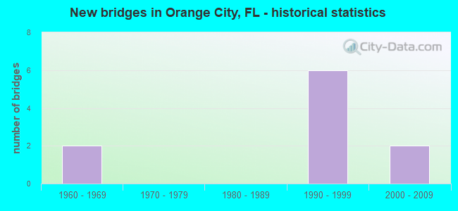
- New bridges - historical statistics
- 31960-1969
- 61990-1999
- 22000-2009
- 12010-2019
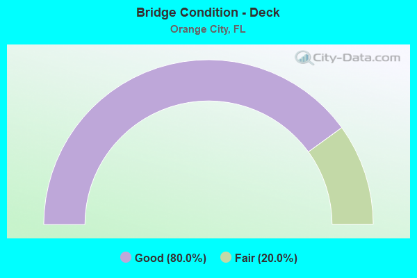
- Bridge Condition - Deck
- 80.0%Good
- 20.0%Fair
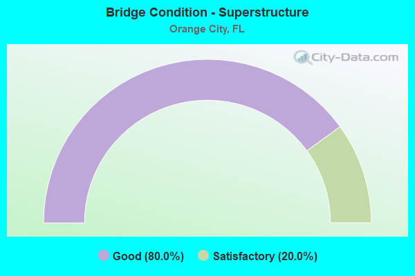
- Bridge Condition - Superstructure
- 80.0%Good
- 20.0%Satisfactory
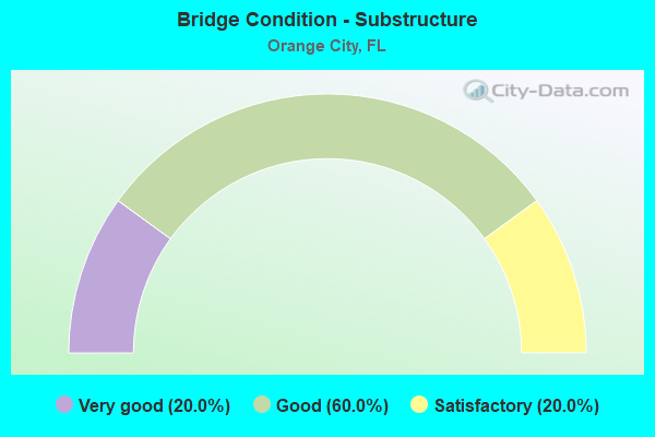
- Bridge Condition - Substructure
- 20.0%Very good
- 60.0%Good
- 20.0%Satisfactory
Find on map >> Show street view
Structure Number: 790055, Location: SR-472 over US-17/92 (Lat: 28.974142, Lng: -81.298989), Route carried "on" structure: State highway 472, Year Built: 1960, Status: Open, Structure Length: 7.07m (23.20ft), Average Daily Traffic: 24,000 (year 2020), Truck Traffic: 12%, Average Future Daily Traffic: 41,640 (year 2042), Design Load: HS 20, Features Intersected: US-17/92
Minimum Vertical Clearance: 30+ m (98+ ft), Kilometerpoint: 0.605, Lanes on structure: 2, Lanes under structure: 4, Owner: State Highway Agency, Approaching Roadway Width: 8.6m (28.2ft), Skew: 3 degrees, Material/Design: Prestressed concrete, Design/Construction: Stringer/Multi-beam, Number Of Spans In Main Unit: 4, Length of Maximum Span: 21.6m (70.9ft), Curb-To-Curb Width: 8.6m (28.2ft), Out-to-Out Width: 10.3m (33.8ft)
Condition: Deck: Fair, Superstructure: Satisfactory, Substructure: Satisfactory, Operating Rating: 43.1 metric tons, Method Used To Determine Operating Rating: Load and Resistance Factor (LRFR), Inventory Rating: 33.3 metric tons, Method Used To Determine Inventory Rating: Load and Resistance Factor (LRFR), Structural Evaluation: Equal to present minimum criteria, Deck Geometry: Meets minimum limits, Underclear: Meets minimum limits, Approach Roadway Alignment: Better than present minimum criteria, Length Of Structure Improvement: 2.13m (6.99ft), Designated Inspection Frequency: Every 24 months, Inspection Date: May 2021, Bridge Improvement Cost: $18,000, Total Project Cost: $340,000, Deck Structure Type: Concrete Cast-file-Place, Wearing Surface/Protective System: Wearing Surface: Monolithic Concrete
Find on map >> Show street view
Structure Number: 790166, Location: Saxon Blvd WB - I-4 (Lat: 28.911256, Lng: -81.271783), Route carried "on" structure: County highway , Year Built: 1993, Status: Open, Structure Length: 7.91m (25.95ft), Average Daily Traffic: 15,750 (year 2020), Truck Traffic: 5%, Average Future Daily Traffic: 27,326 (year 2042), Design Load: HS 20+Mod, Features Intersected: I-4, Facility Carried by Structure: Saxon Blvd WB
Minimum Vertical Clearance: 30+ m (98+ ft), Kilometerpoint: 1.917, Lanes on structure: 3, Lanes under structure: 9, Owner: State Highway Agency, Approaching Roadway Width: 8.5m (27.9ft), Skew: 1 degrees, Material/Design: Prestressed concrete, Design/Construction: Stringer/Multi-beam, Number Of Spans In Main Unit: 3, Length of Maximum Span: 30.4m (99.7ft), Curb or Sidewalk Widths: Left: 1.5m (4.9ft), Right: 0.0m, Curb-To-Curb Width: 18.0m (59.1ft), Out-to-Out Width: 20.3m (66.6ft)
Condition: Deck: Good, Superstructure: Good, Substructure: Good, Operating Rating: 66.2 metric tons, Method Used To Determine Operating Rating: Load Factor (LF), Inventory Rating: 39.7 metric tons, Method Used To Determine Inventory Rating: Load Factor (LF), Structural Evaluation: Better than present minimum criteria, Deck Geometry: Superior to present desirable criteria, Underclear: Somewhat better than minimum adequacy, Approach Roadway Alignment: Equal to present desirable criteria, Designated Inspection Frequency: Every 24 months, Inspection Date: November 2020, Deck Structure Type: Concrete Cast-file-Place, Wearing Surface/Protective System: Wearing Surface: Monolithic Concrete
Find on map >> Show street view
Structure Number: 790167, Location: Saxon Blvd EB - I-4 (Lat: 28.911064, Lng: -81.271886), Route carried "on" structure: County highway , Year Built: 1994, Status: Open, Structure Length: 7.89m (25.89ft), Average Daily Traffic: 15,750 (year 2020), Truck Traffic: 5%, Average Future Daily Traffic: 27,326 (year 2042), Design Load: HS 20+Mod, Features Intersected: I-4, Facility Carried by Structure: Saxon Blvd EB
Minimum Vertical Clearance: 30+ m (98+ ft), Kilometerpoint: 1.917, Lanes on structure: 3, Lanes under structure: 9, Owner: State Highway Agency, Approaching Roadway Width: 8.5m (27.9ft), Skew: 1 degrees, Material/Design: Prestressed concrete, Design/Construction: Stringer/Multi-beam, Number Of Spans In Main Unit: 3, Length of Maximum Span: 30.4m (99.7ft), Curb or Sidewalk Widths: Left: 0.0m, Right: 1.5m (4.9ft), Curb-To-Curb Width: 18.0m (59.1ft), Out-to-Out Width: 20.3m (66.6ft)
Condition: Deck: Good, Superstructure: Good, Substructure: Good, Operating Rating: 66.2 metric tons, Method Used To Determine Operating Rating: Load Factor (LF), Inventory Rating: 39.7 metric tons, Method Used To Determine Inventory Rating: Load Factor (LF), Structural Evaluation: Better than present minimum criteria, Deck Geometry: Superior to present desirable criteria, Underclear: Somewhat better than minimum adequacy, Approach Roadway Alignment: Equal to present desirable criteria, Designated Inspection Frequency: Every 24 months, Inspection Date: November 2020, Deck Structure Type: Concrete Cast-file-Place, Wearing Surface/Protective System: Wearing Surface: Monolithic Concrete
Find on map >> Show street view
Structure Number: 790218, Location: Graves Ave over I-4 (Lat: 28.948678, Lng: -81.259817), Route carried "on" structure: County highway 4, Year Built: 2006, Status: Open, Structure Length: 8.78m (28.81ft), Average Daily Traffic: 15,200 (year 2020), Truck Traffic: 6%, Average Future Daily Traffic: 26,372 (year 2042), Design Load: HL 93, Features Intersected: I-4, Facility Carried by Structure: Graves Ave
Minimum Vertical Clearance: 30+ m (98+ ft), Kilometerpoint: 0.536, Lanes on structure: 2, Lanes under structure: 7, Owner: State Highway Agency, Approaching Roadway Width: 12.5m (41.0ft), Material/Design: Prestressed concrete, Design/Construction: Stringer/Multi-beam, Number Of Spans In Main Unit: 2, Length of Maximum Span: 43.6m (143.0ft), Curb or Sidewalk Widths: Left: 1.5m (4.9ft), Right: 1.5m (4.9ft), Curb-To-Curb Width: 13.4m (44.0ft), Out-to-Out Width: 18.0m (59.1ft)
Condition: Deck: Good, Superstructure: Good, Substructure: Very good, Operating Rating: 65.3 metric tons, Method Used To Determine Operating Rating: Load and Resistance Factor (LRFR), Inventory Rating: 43.5 metric tons, Method Used To Determine Inventory Rating: Load and Resistance Factor (LRFR), Structural Evaluation: Better than present minimum criteria, Deck Geometry: Equal to present minimum criteria, Underclear: Equal to present minimum criteria, Approach Roadway Alignment: Equal to present desirable criteria, Designated Inspection Frequency: Every 24 months, Inspection Date: December 2020, Deck Structure Type: Concrete Cast-file-Place, Wearing Surface/Protective System: Wearing Surface: Monolithic Concrete
Find on map >> Show street view
Structure Number: 794006, Location: 2 miles West of US-17 (Lat: 28.952339, Lng: -81.332231), Route carried "on" structure: County highway , Year Built: 1960, Status: Open, Structure Length: 3.20m (10.50ft), Average Daily Traffic: 1,047 (year 2020), Truck Traffic: 5%, Average Future Daily Traffic: 1,267 (year 2042), Design Load: HS 20, Features Intersected: Seaboard Coastline RR, Facility Carried by Structure: French Avenue
Minimum Vertical Clearance: 30+ m (98+ ft), Kilometerpoint: 0.116, Lanes on structure: 2, Owner: County Highway Agency, Approaching Roadway Width: 6.2m (20.3ft), Material/Design: Prestressed concrete, Design/Construction: Slab, Number Of Spans In Main Unit: 3, Length of Maximum Span: 10.7m (35.1ft), Curb-To-Curb Width: 7.3m (24.0ft), Out-to-Out Width: 8.2m (26.9ft)
Condition: Deck: Good, Superstructure: Good, Substructure: Good, Operating Rating: 50.0 metric tons, Method Used To Determine Operating Rating: Load Factor (LF), Inventory Rating: 30.0 metric tons, Method Used To Determine Inventory Rating: Load Factor (LF), Structural Evaluation: Better than present minimum criteria, Deck Geometry: Meets minimum limits, Underclear: Meets minimum limits, Approach Roadway Alignment: Better than present minimum criteria, Designated Inspection Frequency: Every 24 months, Inspection Date: March 2020, Deck Structure Type: Concrete Precast Panels, Wearing Surface/Protective System: Wearing Surface: Bituminous
Find on map >> Show street view
Structure Number: 790055, Location: SR-472 over US-17/92 (Lat: 28.974142, Lng: -81.298989), Route carried "under" structure: US 17, Year Built: 1960, Structure Length: 0. m, Average Daily Traffic: 52,500 (year 2020), Truck Traffic: 4%, Features Intersected: US-17/92, Facility Carried by Structure: SR-472
Minimum Vertical Clearance: 4.75m (15.58ft), Kilometerpoint: 15.413, Lanes on structure: 2, Lanes under structure: 4, Material/Design: Prestressed concrete, Design/Construction: Stringer/Multi-beam, Length of Maximum Span: 21.6m (70.9ft)
Find on map >> Show street view
Structure Number: 790166, Location: Saxon Blvd WB - I-4 (Lat: 28.911256, Lng: -81.271783), Route carried "under" structure: Interstate 4, Year Built: 1993, Structure Length: 0. m, Average Daily Traffic: 93,000 (year 2020), Truck Traffic: 13%, Features Intersected: I-4, Facility Carried by Structure: Saxon Blvd WB
Minimum Vertical Clearance: 5.15m (16.90ft), Kilometerpoint: 10.221, Lanes on structure: 3, Lanes under structure: 7, Material/Design: Prestressed concrete, Design/Construction: Stringer/Multi-beam, Length of Maximum Span: 30.4m (99.7ft)
Find on map >> Show street view
Structure Number: 790166, Location: Saxon Blvd WB - I-4 (Lat: 28.911256, Lng: -81.271783), Route carried "under" structure: Ramp Other road , Year Built: 1993, Structure Length: 0. m, Average Daily Traffic: 10,000 (year 2012), Truck Traffic: 2%, Features Intersected: I-4, Facility Carried by Structure: Saxon Blvd WB
Minimum Vertical Clearance: 5.30m (17.39ft), Kilometerpoint: 0.702, Lanes on structure: 3, Lanes under structure: 2, Material/Design: Prestressed concrete, Design/Construction: Stringer/Multi-beam, Length of Maximum Span: 30.4m (99.7ft)
Find on map >> Show street view
Structure Number: 790167, Location: Saxon Blvd EB - I-4 (Lat: 28.911064, Lng: -81.271886), Route carried "under" structure: Ramp Other road , Year Built: 1994, Structure Length: 0. m, Average Daily Traffic: 6,800 (year 2020), Truck Traffic: 9%, Features Intersected: I-4, Facility Carried by Structure: Saxon Blvd EB
Minimum Vertical Clearance: 5.49m (18.01ft), Kilometerpoint: 0.702, Lanes on structure: 3, Lanes under structure: 2, Material/Design: Prestressed concrete, Design/Construction: Stringer/Multi-beam, Length of Maximum Span: 30.4m (99.7ft)
Find on map >> Show street view
Structure Number: 790167, Location: Saxon Blvd EB - I-4 (Lat: 28.911064, Lng: -81.271886), Route carried "under" structure: Interstate 4, Year Built: 1994, Structure Length: 0. m, Average Daily Traffic: 93,000 (year 2020), Truck Traffic: 13%, Features Intersected: I-4, Facility Carried by Structure: Saxon Blvd EB
Minimum Vertical Clearance: 4.97m (16.31ft), Kilometerpoint: 10.221, Lanes on structure: 3, Lanes under structure: 7, Material/Design: Prestressed concrete, Design/Construction: Stringer/Multi-beam, Length of Maximum Span: 30.4m (99.7ft)
Find on map >> Show street view
Structure Number: 790218, Location: Graves Ave over I-4 (Lat: 28.948678, Lng: -81.259817), Route carried "under" structure: Interstate 400, Year Built: 2006, Structure Length: 0. m, Average Daily Traffic: 93,000 (year 2020), Truck Traffic: 13%, Features Intersected: I-4, Facility Carried by Structure: Graves Ave
Minimum Vertical Clearance: 5.39m (17.68ft), Kilometerpoint: 14.548, Lanes on structure: 2, Lanes under structure: 7, Material/Design: Prestressed concrete, Design/Construction: Stringer/Multi-beam, Length of Maximum Span: 43.6m (143.0ft)
Find on map >> Show street view
Structure Number: 794199, Location: Over RR@Blue Springs Dr (Lat: 28.942914, Lng: -81.332303), Route carried "under" structure: Other road , Year Built: 2018, Structure Length: 0. m, Features Intersected: CFCR RR, Facility Carried by Structure: Pedestrian Bridge
Minimum Vertical Clearance: 7.28m (23.88ft), Kilometerpoint: 0.000, Material/Design: Steel, Design/Construction: Truss - Thru, Length of Maximum Span: 32.3m (106.0ft)