Bridge Statistics for Northampton, Massachusetts (MA)
Condition, Traffic, Stress, Structural Evaluation, Project Costs
- National Bridge Inventory (NBI) Statistics
- 50Number of bridges
- 568ft / 173mTotal length
- $155,853,000Total costs
- 616,594Total average daily traffic
- 39,502Total average daily truck traffic
- National Bridge Inventory (NBI) Registered Bridges for Northampton
- No street view available for this location
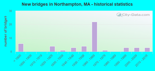
- New bridges - historical statistics
- 6Before 1900
- 41920-1929
- 11930-1939
- 31940-1949
- 41950-1959
- 221960-1969
- 11970-1979
- 31990-1999
- 32000-2009
- 32010-2019
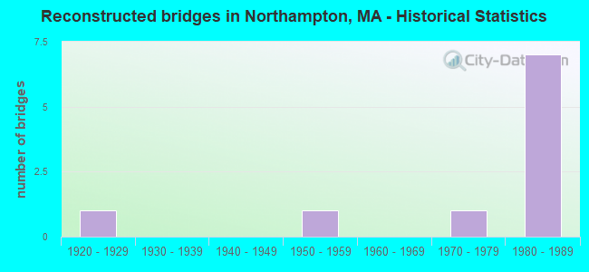
- Reconstructed bridges - Historical Statistics
- 11920-1929
- 01930-1939
- 01940-1949
- 11950-1959
- 01960-1969
- 11970-1979
- 71980-1989
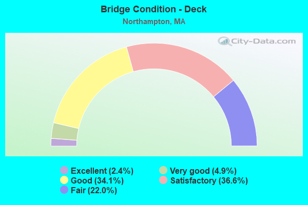
- Bridge Condition - Deck
- 2.4%Excellent
- 4.9%Very good
- 34.1%Good
- 36.6%Satisfactory
- 22.0%Fair
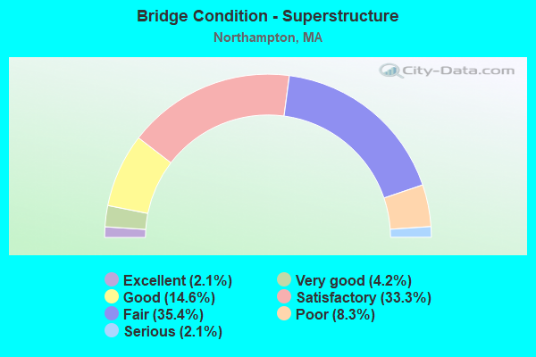
- Bridge Condition - Superstructure
- 2.1%Excellent
- 4.2%Very good
- 14.6%Good
- 33.3%Satisfactory
- 35.4%Fair
- 8.3%Poor
- 2.1%Serious
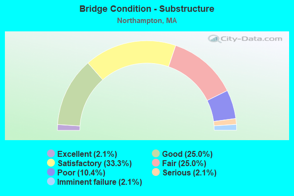
- Bridge Condition - Substructure
- 2.1%Excellent
- 25.0%Good
- 33.3%Satisfactory
- 25.0%Fair
- 10.4%Poor
- 2.1%Serious
- 2.1%Imminent failure
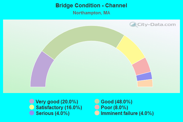
- Bridge Condition - Channel
- 20.0%Very good
- 48.0%Good
- 16.0%Satisfactory
- 8.0%Poor
- 4.0%Serious
- 4.0%Imminent failure
Find on map >> Show street view
Structure Number: H1102512VDOTNBI, Location: .2 M E JCT US 5 & ST 10 (Lat: 42.360225, Lng: -72.634969), Route carried "on" structure: City street , Year Built: 1963, Status: Open, Structure Length: 7.72m (25.33ft), Average Daily Traffic: 13,319 (year 2014), Truck Traffic: 6%, Average Future Daily Traffic: 8,054 (year 2031), Design Load: H 20, Features Intersected: RR BMRR, Facility Carried by Structure: HWY ELM ST
Minimum Vertical Clearance: 30+ m (98+ ft), Kilometerpoint: 0.000, Lanes on structure: 2, Owner: State Highway Agency, Approaching Roadway Width: 13.4m (44.0ft), Material/Design: Steel, Design/Construction: Stringer/Multi-beam, Number Of Spans In Main Unit: 4, Length of Maximum Span: 18.6m (61.0ft), Curb or Sidewalk Widths: Left: 0.5m (1.6ft), Right: 1.5m (4.9ft), Curb-To-Curb Width: 13.4m (44.0ft), Out-to-Out Width: 16.1m (52.8ft)
Condition: Deck: Fair, Superstructure: Fair, Substructure: Poor, Operating Rating: 48.7 metric tons, Method Used To Determine Operating Rating: Load Factor (LF), Inventory Rating: 29.2 metric tons, Method Used To Determine Inventory Rating: Load Factor (LF), Structural Evaluation: Meets minimum limits, Deck Geometry: Equal to present minimum criteria, Underclear: Better than present minimum criteria, Approach Roadway Alignment: Equal to present desirable criteria, Length Of Structure Improvement: 8.80m (28.87ft), Designated Inspection Frequency: Every 12 months, Other Special Inspection Frequency: Every 12 months, Inspection Date: October 2020, Other Special Inspection Date: October 2021, Bridge Improvement Cost: $7,422,000, Roadway Improvement Cost: $743,000, Total Project Cost: $11,134,000 ( Estimate for 2022), Deck Structure Type: Concrete Cast-file-Place, Wearing Surface/Protective System: Wearing Surface: Bituminous, Membrane: Built-up
Find on map >> Show street view
Structure Number: H1102612UDOTNBI, Location: MM 27.3 ON I-91 (Lat: 42.360558, Lng: -72.636733), Route carried "on" structure: City street , Year Built: 1963, Year Reconstructed: 1987, Status: Open, Structure Length: 8.50m (27.89ft), Average Daily Traffic: 20,172 (year 2016), Truck Traffic: 5%, Average Future Daily Traffic: 9,190 (year 2031), Design Load: H 20, Features Intersected: I 91, Facility Carried by Structure: HWY ELM ST
Minimum Vertical Clearance: 30+ m (98+ ft), Kilometerpoint: 0.000, Lanes on structure: 2, Lanes under structure: 4, Owner: State Highway Agency, Approaching Roadway Width: 11.7m (38.4ft), Material/Design: Steel, Design/Construction: Stringer/Multi-beam, Number Of Spans In Main Unit: 5, Length of Maximum Span: 19.9m (65.3ft), Curb or Sidewalk Widths: Left: 0.2m (0.7ft), Right: 1.5m (4.9ft), Curb-To-Curb Width: 11.7m (38.4ft), Out-to-Out Width: 14.3m (46.9ft)
Condition: Deck: Good, Superstructure: Satisfactory, Substructure: Satisfactory, Operating Rating: 39.6 metric tons, Method Used To Determine Operating Rating: Allowable Stress (AS), Inventory Rating: 22.4 metric tons, Method Used To Determine Inventory Rating: Allowable Stress (AS), Structural Evaluation: Somewhat better than minimum adequacy, Deck Geometry: Somewhat better than minimum adequacy, Underclear: High priority of corrective action, Approach Roadway Alignment: Equal to present desirable criteria, Length Of Structure Improvement: 8.60m (28.22ft), Designated Inspection Frequency: Every 24 months, Inspection Date: October 2020, Bridge Improvement Cost: $4,831,000, Roadway Improvement Cost: $484,000, Total Project Cost: $7,247,000 ( Estimate for 2022), Deck Structure Type: Concrete Cast-file-Place, Wearing Surface/Protective System: Wearing Surface: Latex Concrete
Find on map >> Show street view
Structure Number: H1102813DDOTNBI, Location: MM 28.7 ON I-91 (Lat: 42.381744, Lng: -72.631389), Route carried "on" structure: City street , Year Built: 1963, Status: Posted for load, Structure Length: 7.79m (25.56ft), Average Daily Traffic: 1,940 (year 2020), Truck Traffic: 20%, Average Future Daily Traffic: 2,369 (year 2031), Design Load: H 20, Features Intersected: I 91, Facility Carried by Structure: HWY CHESTNUT ST
Minimum Vertical Clearance: 30+ m (98+ ft), Kilometerpoint: 0.000, Lanes on structure: 2, Lanes under structure: 4, Owner: State Highway Agency, Approaching Roadway Width: 9.8m (32.2ft), Material/Design: Steel, Design/Construction: Stringer/Multi-beam, Number Of Spans In Main Unit: 5, Length of Maximum Span: 18.6m (61.0ft), Curb or Sidewalk Widths: Left: 0.5m (1.6ft), Right: 1.5m (4.9ft), Curb-To-Curb Width: 9.8m (32.2ft), Out-to-Out Width: 12.5m (41.0ft)
Condition: Deck: Satisfactory, Superstructure: Fair, Substructure: Fair, Operating Rating: 37.5 metric tons, Method Used To Determine Operating Rating: Allowable Stress (AS), Inventory Rating: 18.7 metric tons, Method Used To Determine Inventory Rating: Allowable Stress (AS), Structural Evaluation: Somewhat better than minimum adequacy, Deck Geometry: Somewhat better than minimum adequacy, Underclear: High priority of corrective action, Approach Roadway Alignment: Equal to present desirable criteria, Length Of Structure Improvement: 7.80m (25.59ft), Designated Inspection Frequency: Every 24 months, Inspection Date: November 2020, Bridge Improvement Cost: $3,830,000, Roadway Improvement Cost: $384,000, Total Project Cost: $5,746,000 ( Estimate for 2022), Deck Structure Type: Concrete Cast-file-Place, Wearing Surface/Protective System: Wearing Surface: Bituminous, Membrane: Built-up
Find on map >> Show street view
Structure Number: N190030V3DOTNBI, Location: .1 M S JCT ST 9 (Lat: 42.316111, Lng: -72.633700), Route carried "on" structure: State highway 10, Year Built: 1948, Status: Open, Structure Length: 3.04m (9.97ft), Average Daily Traffic: 26,250 (year 2017), Truck Traffic: 4%, Average Future Daily Traffic: 28,112 (year 2032), Design Load: H 20, Features Intersected: OTHER MANHAN RAIL TRAIL
Minimum Vertical Clearance: 30+ m (98+ ft), Kilometerpoint: 43.290, Lanes on structure: 2, Base Highway Network: Yes, Owner: State Highway Agency, Approaching Roadway Width: 12.2m (40.0ft), Material/Design: Steel continuous, Design/Construction: Stringer/Multi-beam, Number Of Spans In Main Unit: 2, Length of Maximum Span: 19.2m (63.0ft), Curb or Sidewalk Widths: Left: 1.9m (6.2ft), Right: 1.9m (6.2ft), Curb-To-Curb Width: 12.2m (40.0ft), Out-to-Out Width: 16.9m (55.4ft)
Condition: Deck: Good, Superstructure: Fair, Substructure: Fair, Operating Rating: 53.7 metric tons, Method Used To Determine Operating Rating: Load Factor (LF), Inventory Rating: 32.1 metric tons, Method Used To Determine Inventory Rating: Load Factor (LF), Structural Evaluation: Somewhat better than minimum adequacy, Deck Geometry: Somewhat better than minimum adequacy, Approach Roadway Alignment: Better than present minimum criteria, Length Of Structure Improvement: 3.10m (10.17ft), Designated Inspection Frequency: Every 24 months, Inspection Date: July 2021, Bridge Improvement Cost: $2,058,000, Roadway Improvement Cost: $206,000, Total Project Cost: $3,088,000 ( Estimate for 2022), Deck Structure Type: Concrete Cast-file-Place, Wearing Surface/Protective System: Wearing Surface: Bituminous, Membrane: Built-up
Find on map >> Show street view
Structure Number: N190110MJMUNNBI, Location: 0.15 M N OF PROSPECT ST (Lat: 42.332056, Lng: -72.645022), Route carried "on" structure: City street , Year Built: 1890, Year Reconstructed: 1977, Status: Open, Structure Length: 0.78m (2.56ft), Average Daily Traffic: 7,682 (year 2017), Truck Traffic: 5%, Average Future Daily Traffic: 10,265 (year 2031), Design Load: H 20, Features Intersected: OTHER NORTHAMPTON BK WAY, Facility Carried by Structure: HWY JACKSON ST
Minimum Vertical Clearance: 30+ m (98+ ft), Kilometerpoint: 0.290, Lanes on structure: 2, Owner: City or Municipal Highway Agency, Approaching Roadway Width: 7.3m (24.0ft), Skew: 1 degrees, Material/Design: Prestressed concrete, Design/Construction: Slab, Number Of Spans In Main Unit: 1, Length of Maximum Span: 7.5m (24.6ft), Curb or Sidewalk Widths: Left: 0.2m (0.7ft), Right: 1.4m (4.6ft), Curb-To-Curb Width: 7.3m (24.0ft), Out-to-Out Width: 9.9m (32.5ft)
Condition: Deck: Satisfactory, Superstructure: Satisfactory, Substructure: Fair, Operating Rating: 69.0 metric tons, Method Used To Determine Operating Rating: Load Factor (LF), Inventory Rating: 41.1 metric tons, Method Used To Determine Inventory Rating: Load Factor (LF), Structural Evaluation: Somewhat better than minimum adequacy, Deck Geometry: High priority of replacement, Approach Roadway Alignment: Equal to present minimum criteria, Length Of Structure Improvement: 0.80m (2.62ft), Designated Inspection Frequency: Every 24 months, Inspection Date: June 2020, Bridge Improvement Cost: $312,000, Roadway Improvement Cost: $32,000, Total Project Cost: $469,000 ( Estimate for 2022), Deck Structure Type: Concrete Precast Panels, Wearing Surface/Protective System: Wearing Surface: Bituminous, Membrane: Preformed Fabric
Find on map >> Show street view
Structure Number: N190190V2DOTNBI, Location: .2 M S JCT ST 9 (Lat: 42.315136, Lng: -72.633444), Route carried "on" structure: State highway 10, Year Built: 1948, Status: Open, Structure Length: 1.32m (4.33ft), Average Daily Traffic: 27,026 (year 2017), Truck Traffic: 3%, Average Future Daily Traffic: 27,638 (year 2032), Design Load: H 20, Features Intersected: HWY CLARK AVE
Minimum Vertical Clearance: 30+ m (98+ ft), Kilometerpoint: 43.129, Lanes on structure: 3, Lanes under structure: 2, Base Highway Network: Yes, Owner: State Highway Agency, Approaching Roadway Width: 12.2m (40.0ft), Skew: 2 degrees, Material/Design: Steel, Design/Construction: Stringer/Multi-beam, Number Of Spans In Main Unit: 1, Length of Maximum Span: 11.8m (38.7ft), Curb or Sidewalk Widths: Left: 1.9m (6.2ft), Right: 1.9m (6.2ft), Curb-To-Curb Width: 12.2m (40.0ft), Out-to-Out Width: 16.9m (55.4ft)
Condition: Deck: Good, Superstructure: Satisfactory, Substructure: Satisfactory, Operating Rating: 45.9 metric tons, Method Used To Determine Operating Rating: Load Factor (LF), Inventory Rating: 29.7 metric tons, Method Used To Determine Inventory Rating: Load Factor (LF), Structural Evaluation: Equal to present minimum criteria, Deck Geometry: Meets minimum limits, Underclear: High priority of corrective action, Approach Roadway Alignment: Equal to present minimum criteria, Length Of Structure Improvement: 1.40m (4.59ft), Designated Inspection Frequency: Every 24 months, Inspection Date: October 2021, Bridge Improvement Cost: $930,000, Roadway Improvement Cost: $94,000, Total Project Cost: $1,396,000 ( Estimate for 2022), Deck Structure Type: Concrete Cast-file-Place, Wearing Surface/Protective System: Wearing Surface: Bituminous, Membrane: Built-up
Find on map >> Show street view
Structure Number: N1902111MDOTNBI, Location: .4 MI W JCT ST 9 (Lat: 42.312903, Lng: -72.640639), Route carried "on" structure: State highway 66, Year Built: 1924, Status: Open, Structure Length: 3.75m (12.30ft), Average Daily Traffic: 11,767 (year 2018), Truck Traffic: 5%, Average Future Daily Traffic: 5,420 (year 2031), Design Load: HS 20, Features Intersected: WATER MILL RIVER
Minimum Vertical Clearance: 30+ m (98+ ft), Kilometerpoint: 21.227, Lanes on structure: 2, Owner: State Highway Agency, Approaching Roadway Width: 7.9m (25.9ft), Material/Design: Concrete, Design/Construction: Arch - Deck, Number Of Spans In Main Unit: 2, Length of Maximum Span: 17.1m (56.1ft), Curb or Sidewalk Widths: Left: 1.2m (3.9ft), Right: 1.2m (3.9ft), Curb-To-Curb Width: 7.9m (25.9ft), Out-to-Out Width: 11.8m (38.7ft)
Condition: Superstructure: Satisfactory, Substructure: Satisfactory, Channel: Satisfactory, Inventory Rating: 70.3 metric tons, Method Used To Determine Inventory Rating: Load Factor (LF), Structural Evaluation: Equal to present minimum criteria, Deck Geometry: High priority of replacement, Waterway Adequacy: Equal to present desirable criteria, Approach Roadway Alignment: Better than present minimum criteria, Length Of Structure Improvement: 3.80m (12.47ft), Designated Inspection Frequency: Every 24 months, Underwater Inspection Frequency: Every 36 months, Inspection Date: June 2020, Underwater Inspection Date: September 2019, Bridge Improvement Cost: $1,971,000, Roadway Improvement Cost: $198,000, Total Project Cost: $2,957,000 ( Estimate for 2022)
Find on map >> Show street view
Structure Number: N190238RLMUNNBI, Location: .05M S OF RT9 IN FLORENCE (Lat: 42.329083, Lng: -72.675244), Route carried "on" structure: City street , Year Built: 2005, Status: Open, Structure Length: 3.44m (11.29ft), Average Daily Traffic: 3,103 (year 2016), Truck Traffic: 3%, Average Future Daily Traffic: 8,986 (year 2033), Design Load: HS 25 or greater, Features Intersected: WATER MILL RIVER, Facility Carried by Structure: HWY BLISS ST
Minimum Vertical Clearance: 30+ m (98+ ft), Kilometerpoint: 0.370, Lanes on structure: 2, Owner: City or Municipal Highway Agency, Approaching Roadway Width: 6.9m (22.6ft), Material/Design: Prestressed concrete, Design/Construction: Box Beam or Girders - Single/Spread, Number Of Spans In Main Unit: 1, Length of Maximum Span: 33.2m (108.9ft), Curb or Sidewalk Widths: Left: 1.5m (4.9ft), Right: 0.0m, Curb-To-Curb Width: 6.5m (21.3ft), Out-to-Out Width: 8.9m (29.2ft)
Condition: Deck: Good, Superstructure: Very good, Substructure: Good, Channel: Very good, Inventory Rating: 78.4 metric tons, Method Used To Determine Inventory Rating: Load Factor (LF), Structural Evaluation: Better than present minimum criteria, Deck Geometry: High priority of replacement, Waterway Adequacy: Equal to present desirable criteria, Approach Roadway Alignment: Equal to present desirable criteria, Length Of Structure Improvement: 3.50m (11.48ft), Designated Inspection Frequency: Every 24 months, Inspection Date: January 2022, Bridge Improvement Cost: $2,277,000, Roadway Improvement Cost: $228,000, Total Project Cost: $3,416,000 ( Estimate for 2022), Deck Structure Type: Concrete Cast-file-Place, Wearing Surface/Protective System: Wearing Surface: Integral Concrete, Deck Protection: Epoxy Coated Reinforcing
Find on map >> Show street view
Structure Number: N190240MEMUNNBI, Location: 300' E INT FLORENCE RD (Lat: 42.330639, Lng: -72.678944), Route carried "on" structure: City street , Year Built: 1850, Year Reconstructed: 1961, Status: Temporarily open, Structure Length: 2.95m (9.68ft), Average Daily Traffic: 14,741 (year 2019), Truck Traffic: 10%, Average Future Daily Traffic: 35,945 (year 2031), Design Load: H 20, Features Intersected: WATER MILL RIVER, Facility Carried by Structure: HWY PINE ST
Minimum Vertical Clearance: 30+ m (98+ ft), Kilometerpoint: 0.080, Lanes on structure: 2, Owner: City or Municipal Highway Agency, Approaching Roadway Width: 9.1m (29.9ft), Material/Design: Steel, Design/Construction: Stringer/Multi-beam, Number Of Spans In Main Unit: 1, Length of Maximum Span: 28.4m (93.2ft), Curb or Sidewalk Widths: Left: 1.5m (4.9ft), Right: 1.5m (4.9ft), Curb-To-Curb Width: 9.1m (29.9ft), Out-to-Out Width: 13.0m (42.7ft)
Condition: Deck: Satisfactory, Superstructure: Fair, Substructure: Fair, Channel: Satisfactory, Operating Rating: 61.3 metric tons, Method Used To Determine Operating Rating: Load Factor (LF), Inventory Rating: 36.7 metric tons, Method Used To Determine Inventory Rating: Load Factor (LF), Structural Evaluation: Somewhat better than minimum adequacy, Deck Geometry: High priority of corrective action, Waterway Adequacy: Better than present minimum criteria, Approach Roadway Alignment: Better than present minimum criteria, Length Of Structure Improvement: 3.00m (9.84ft), Designated Inspection Frequency: Every 24 months, Underwater Inspection Frequency: Every 36 months, Inspection Date: May 2020, Underwater Inspection Date: August 2021, Bridge Improvement Cost: $1,532,000, Roadway Improvement Cost: $154,000, Total Project Cost: $2,299,000 ( Estimate for 2022), Deck Structure Type: Concrete Cast-file-Place, Wearing Surface/Protective System: Wearing Surface: Bituminous, Membrane: Built-up
Find on map >> Show street view
Structure Number: N190250MGMUNNBI, Location: 125' W OF JCT. CORTICELLI (Lat: 42.334056, Lng: -72.677489), Route carried "on" structure: City street , Year Built: 1977, Status: Open, Structure Length: 2.18m (7.15ft), Average Daily Traffic: 3,571 (year 2016), Truck Traffic: 1%, Average Future Daily Traffic: 3,269 (year 2032), Design Load: H 20, Features Intersected: WATER MILL RIVER, Facility Carried by Structure: HWY MEADOW ST
Minimum Vertical Clearance: 30+ m (98+ ft), Kilometerpoint: 0.547, Lanes on structure: 2, Owner: City or Municipal Highway Agency, Approaching Roadway Width: 8.5m (27.9ft), Material/Design: Prestressed concrete, Design/Construction: Box Beam or Girders - Multiple, Number Of Spans In Main Unit: 1, Length of Maximum Span: 21.3m (69.9ft), Curb or Sidewalk Widths: Left: 0.5m (1.6ft), Right: 1.5m (4.9ft), Curb-To-Curb Width: 8.5m (27.9ft), Out-to-Out Width: 11.4m (37.4ft)
Condition: Deck: Satisfactory, Superstructure: Satisfactory, Substructure: Good, Channel: Good, Operating Rating: 67.1 metric tons, Method Used To Determine Operating Rating: Load Factor (LF), Inventory Rating: 40.2 metric tons, Method Used To Determine Inventory Rating: Load Factor (LF), Structural Evaluation: Equal to present minimum criteria, Deck Geometry: Meets minimum limits, Waterway Adequacy: Better than present minimum criteria, Approach Roadway Alignment: Somewhat better than minimum adequacy, Length Of Structure Improvement: 2.20m (7.22ft), Designated Inspection Frequency: Every 24 months, Inspection Date: April 2021, Bridge Improvement Cost: $1,017,000, Roadway Improvement Cost: $102,000, Total Project Cost: $1,526,000 ( Estimate for 2022), Deck Structure Type: Concrete Precast Panels, Wearing Surface/Protective System: Wearing Surface: Bituminous, Membrane: Built-up
Find on map >> Show street view
Structure Number: N190260MPMUNNBI, Location: JCT ARCH ST (Lat: 42.347694, Lng: -72.700750), Route carried "on" structure: City street , Year Built: 1925, Year Reconstructed: 1993, Status: Open, Structure Length: 2.01m (6.59ft), Average Daily Traffic: 1,500 (year 2018), Average Future Daily Traffic: 4,738 (year 2031), Features Intersected: WATER MILL RIVER, Facility Carried by Structure: HWY MAIN ST LEED
Minimum Vertical Clearance: 30+ m (98+ ft), Kilometerpoint: 0.177, Lanes on structure: 2, Owner: City or Municipal Highway Agency, Approaching Roadway Width: 6.7m (22.0ft), Skew: 1 degrees, Material/Design: Concrete, Design/Construction: Arch - Deck, Number Of Spans In Main Unit: 1, Length of Maximum Span: 20.1m (65.9ft), Curb or Sidewalk Widths: Left: 0.0m, Right: 1.5m (4.9ft), Curb-To-Curb Width: 6.7m (22.0ft), Out-to-Out Width: 9.2m (30.2ft)
Condition: Superstructure: Satisfactory, Substructure: Satisfactory, Channel: Good, Operating Rating: 74.0 metric tons, Method Used To Determine Operating Rating: Allowable Stress (AS), Inventory Rating: 42.2 metric tons, Method Used To Determine Inventory Rating: Allowable Stress (AS), Structural Evaluation: Equal to present minimum criteria, Deck Geometry: High priority of corrective action, Waterway Adequacy: Somewhat better than minimum adequacy, Approach Roadway Alignment: High priority of corrective action, Length Of Structure Improvement: 2.80m (9.19ft), Designated Inspection Frequency: Every 24 months, Inspection Date: July 2020, Bridge Improvement Cost: $2,332,000, Roadway Improvement Cost: $234,000, Total Project Cost: $3,499,000 ( Estimate for 2022), Wearing Surface/Protective System: Wearing Surface: Bituminous
Find on map >> Show street view
Structure Number: N190260MQMUNNBI, Location: JCT ARCH ST (Lat: 42.347444, Lng: -72.700722), Route carried "on" structure: City street , Year Built: 1850, Year Reconstructed: 1925, Status: Posted for load, Structure Length: 0.94m (3.08ft), Average Daily Traffic: 1,500 (year 2018), Average Future Daily Traffic: 4,738 (year 2031), Features Intersected: WATER SLUICEWAY, Facility Carried by Structure: HWY MAIN ST LEED
Minimum Vertical Clearance: 30+ m (98+ ft), Kilometerpoint: 0.129, Lanes on structure: 2, Owner: City or Municipal Highway Agency, Approaching Roadway Width: 6.7m (22.0ft), Skew: 1 degrees, Material/Design: Steel, Design/Construction: Stringer/Multi-beam, Number Of Spans In Main Unit: 1, Length of Maximum Span: 8.3m (27.2ft), Curb or Sidewalk Widths: Left: 0.0m, Right: 1.5m (4.9ft), Curb-To-Curb Width: 6.7m (22.0ft), Out-to-Out Width: 9.2m (30.2ft)
Condition: Deck: Fair, Superstructure: Fair, Substructure: Satisfactory, Channel: Good, Operating Rating: 38.4 metric tons, Method Used To Determine Operating Rating: Load Factor (LF), Inventory Rating: 23.0 metric tons, Method Used To Determine Inventory Rating: Load Factor (LF), Structural Evaluation: Somewhat better than minimum adequacy, Deck Geometry: High priority of corrective action, Waterway Adequacy: Better than present minimum criteria, Approach Roadway Alignment: High priority of corrective action, Length Of Structure Improvement: 1.00m (3.28ft), Designated Inspection Frequency: Every 24 months, Inspection Date: July 2020, Bridge Improvement Cost: $362,000, Roadway Improvement Cost: $37,000, Total Project Cost: $544,000 ( Estimate for 2022), Deck Structure Type: Concrete Cast-file-Place, Wearing Surface/Protective System: Wearing Surface: Bituminous
Find on map >> Show street view
Structure Number: N190280MFMUNNBI, Location: AT MILL RIVER (Lat: 42.353986, Lng: -72.700950), Route carried "on" structure: City street , Year Built: 1991, Status: Open, Structure Length: 2.54m (8.33ft), Average Daily Traffic: 4,525 (year 2016), Truck Traffic: 6%, Average Future Daily Traffic: 8,576 (year 2031), Design Load: HS 20, Features Intersected: WATER MILL RIVER, Facility Carried by Structure: HWY MULBERRY ST
Minimum Vertical Clearance: 30+ m (98+ ft), Kilometerpoint: 0.161, Lanes on structure: 2, Owner: City or Municipal Highway Agency, Approaching Roadway Width: 9.1m (29.9ft), Material/Design: Steel, Design/Construction: Stringer/Multi-beam, Number Of Spans In Main Unit: 1, Length of Maximum Span: 24.4m (80.1ft), Curb or Sidewalk Widths: Left: 1.5m (4.9ft), Right: 0.4m (1.3ft), Curb-To-Curb Width: 9.1m (29.9ft), Out-to-Out Width: 11.7m (38.4ft)
Condition: Deck: Good, Superstructure: Good, Substructure: Good, Channel: Good, Operating Rating: 60.9 metric tons, Method Used To Determine Operating Rating: Allowable Stress (AS), Inventory Rating: 21.8 metric tons, Method Used To Determine Inventory Rating: Allowable Stress (AS), Structural Evaluation: Somewhat better than minimum adequacy, Deck Geometry: Meets minimum limits, Waterway Adequacy: Better than present minimum criteria, Approach Roadway Alignment: Equal to present minimum criteria, Length Of Structure Improvement: 2.60m (8.53ft), Designated Inspection Frequency: Every 24 months, Inspection Date: June 2020, Bridge Improvement Cost: $1,195,000, Roadway Improvement Cost: $120,000, Total Project Cost: $1,793,000 ( Estimate for 2022), Deck Structure Type: Concrete Cast-file-Place, Wearing Surface/Protective System: Wearing Surface: Bituminous, Membrane: Preformed Fabric, Deck Protection: Epoxy Coated Reinforcing
Find on map >> Show street view
Structure Number: N19029B7PMUNNBI, Location: .08 M S WLLMSBRG TOWN-LIN (Lat: 42.366622, Lng: -72.702531), Route carried "on" structure: City street , Year Built: 2012, Status: Open, Structure Length: 3.40m (11.15ft), Average Daily Traffic: 1,200 (year 2003), Truck Traffic: 2%, Design Load: HS 25 or greater, Features Intersected: WATER MILL RIVER, Facility Carried by Structure: HWY RIVER RD
Minimum Vertical Clearance: 30+ m (98+ ft), Kilometerpoint: 1.400, Lanes on structure: 2, Owner: City or Municipal Highway Agency, Approaching Roadway Width: 9.7m (31.8ft), Skew: 4 degrees, Material/Design: Prestressed concrete, Design/Construction: Stringer/Multi-beam, Number Of Spans In Main Unit: 1, Length of Maximum Span: 31.5m (103.3ft), Curb-To-Curb Width: 8.5m (27.9ft), Out-to-Out Width: 9.5m (31.2ft)
Condition: Deck: Very good, Superstructure: Good, Substructure: Good, Channel: Very good, Operating Rating: 77.3 metric tons, Method Used To Determine Operating Rating: Load Factor (LF), Inventory Rating: 46.3 metric tons, Method Used To Determine Inventory Rating: Load Factor (LF), Structural Evaluation: Better than present minimum criteria, Deck Geometry: Somewhat better than minimum adequacy, Waterway Adequacy: Equal to present desirable criteria, Approach Roadway Alignment: Equal to present minimum criteria, Length Of Structure Improvement: 3.50m (11.48ft), Designated Inspection Frequency: Every 24 months, Inspection Date: August 2020, Bridge Improvement Cost: $1,606,000, Roadway Improvement Cost: $161,000, Total Project Cost: $2,410,000 ( Estimate for 2022), Deck Structure Type: Concrete Cast-file-Place, Wearing Surface/Protective System: Wearing Surface: Bituminous, Membrane: Preformed Fabric, Deck Protection: Epoxy Coated Reinforcing
Find on map >> Show street view
Structure Number: N190300RDMUNNBI, Location: 0.1M S OF RESERVOIR RD (Lat: 42.354033, Lng: -72.703014), Route carried "on" structure: City street , Year Built: 1929, Status: Open, Structure Length: 0.91m (2.99ft), Average Daily Traffic: 259 (year 2001), Truck Traffic: 6%, Average Future Daily Traffic: 409 (year 2032), Features Intersected: WATER ROBERTS MEADOW BRK, Facility Carried by Structure: HWY WATER ST
Minimum Vertical Clearance: 30+ m (98+ ft), Kilometerpoint: 0.370, Lanes on structure: 2, Owner: City or Municipal Highway Agency, Approaching Roadway Width: 7.6m (24.9ft), Material/Design: Concrete, Design/Construction: Arch - Deck, Number Of Spans In Main Unit: 1, Length of Maximum Span: 9.1m (29.9ft), Curb or Sidewalk Widths: Left: 0.3m (1.0ft), Right: 0.3m (1.0ft), Curb-To-Curb Width: 7.9m (25.9ft), Out-to-Out Width: 9.1m (29.9ft)
Condition: Superstructure: Fair, Substructure: Satisfactory, Channel: Good, Operating Rating: 73.9 metric tons, Method Used To Determine Operating Rating: Allowable Stress (AS), Inventory Rating: 52.1 metric tons, Method Used To Determine Inventory Rating: Allowable Stress (AS), Structural Evaluation: Somewhat better than minimum adequacy, Deck Geometry: Somewhat better than minimum adequacy, Waterway Adequacy: Better than present minimum criteria, Approach Roadway Alignment: Better than present minimum criteria, Length Of Structure Improvement: 1.00m (3.28ft), Designated Inspection Frequency: Every 24 months, Inspection Date: Febuary 2021, Bridge Improvement Cost: $358,000, Roadway Improvement Cost: $36,000, Total Project Cost: $538,000 ( Estimate for 2022)
Find on map >> Show street view
Structure Number: N190310MNMUNNBI, Location: 300 FT WEST OF WATER ST (Lat: 42.353811, Lng: -72.705608), Route carried "on" structure: City street , Year Built: 1956, Status: Open, Structure Length: 2.26m (7.41ft), Average Daily Traffic: 1,163 (year 2019), Truck Traffic: 6%, Average Future Daily Traffic: 2,037 (year 2032), Design Load: H 20, Features Intersected: WATER ROBERTS MEADOW BRK, Facility Carried by Structure: HWY RESERVOIR RD
Minimum Vertical Clearance: 30+ m (98+ ft), Kilometerpoint: 1.931, Lanes on structure: 2, Owner: City or Municipal Highway Agency, Approaching Roadway Width: 7.6m (24.9ft), Skew: 5 degrees, Material/Design: Steel, Design/Construction: Stringer/Multi-beam, Number Of Spans In Main Unit: 1, Length of Maximum Span: 20.1m (65.9ft), Curb or Sidewalk Widths: Left: 0.3m (1.0ft), Right: 1.5m (4.9ft), Curb-To-Curb Width: 7.9m (25.9ft), Out-to-Out Width: 10.5m (34.4ft)
Condition: Deck: Satisfactory, Superstructure: Satisfactory, Substructure: Satisfactory, Channel: Satisfactory, Operating Rating: 37.8 metric tons, Method Used To Determine Operating Rating: Allowable Stress (AS), Inventory Rating: 21.0 metric tons, Method Used To Determine Inventory Rating: Allowable Stress (AS), Structural Evaluation: Somewhat better than minimum adequacy, Deck Geometry: Meets minimum limits, Waterway Adequacy: Somewhat better than minimum adequacy, Approach Roadway Alignment: Somewhat better than minimum adequacy, Length Of Structure Improvement: 2.30m (7.55ft), Designated Inspection Frequency: Every 24 months, Inspection Date: March 2021, Bridge Improvement Cost: $949,000, Roadway Improvement Cost: $95,000, Total Project Cost: $1,424,000 ( Estimate for 2022), Deck Structure Type: Concrete Cast-file-Place, Wearing Surface/Protective System: Wearing Surface: Bituminous
Find on map >> Show street view
Structure Number: N19033AMXMUNNBI, Location: AT INT MONTAGUE RD (Lat: 42.336350, Lng: -72.736303), Route carried "on" structure: City street , Year Built: 2002, Status: Open, Structure Length: 1.44m (4.72ft), Average Daily Traffic: 1,940 (year 2013), Truck Traffic: 6%, Average Future Daily Traffic: 4,580 (year 2032), Design Load: HS 20, Features Intersected: WATER ROBERTS MEADOW BRK, Facility Carried by Structure: HWY CHESTFLD RD
Minimum Vertical Clearance: 30+ m (98+ ft), Kilometerpoint: 0.274, Lanes on structure: 2, Owner: City or Municipal Highway Agency, Approaching Roadway Width: 6.7m (22.0ft), Material/Design: Concrete, Design/Construction: Arch - Deck, Number Of Spans In Main Unit: 1, Length of Maximum Span: 14.4m (47.2ft), Curb-To-Curb Width: 6.7m (22.0ft), Out-to-Out Width: 8.4m (27.6ft)
Condition: Superstructure: Good, Substructure: Good, Channel: Good, Inventory Rating: 78.8 metric tons, Method Used To Determine Inventory Rating: Load Factor (LF), Structural Evaluation: Better than present minimum criteria, Deck Geometry: High priority of corrective action, Waterway Adequacy: Superior to present desirable criteria, Approach Roadway Alignment: Equal to present desirable criteria, Length Of Structure Improvement: 1.50m (4.92ft), Designated Inspection Frequency: Every 24 months, Inspection Date: December 2021, Bridge Improvement Cost: $948,000, Roadway Improvement Cost: $95,000, Total Project Cost: $1,423,000 ( Estimate for 2022)
Find on map >> Show street view
Structure Number: N19035BDBMUNNBI, Location: 1MI E OF WSTHMPTN (Lat: 42.339361, Lng: -72.725083), Route carried "on" structure: City street , Year Built: 2013, Status: Open, Structure Length: 1.39m (4.56ft), Average Daily Traffic: 1,500 (year 2003), Truck Traffic: 6%, Design Load: HL 93, Features Intersected: WATER ROBERTS MEADOW BRK, Facility Carried by Structure: HWY KENNEDY RD
Minimum Vertical Clearance: 30+ m (98+ ft), Kilometerpoint: 0.064, Lanes on structure: 2, Owner: City or Municipal Highway Agency, Approaching Roadway Width: 9.0m (29.5ft), Material/Design: Prestressed concrete, Design/Construction: Slab, Number Of Spans In Main Unit: 1, Length of Maximum Span: 13.4m (44.0ft), Curb or Sidewalk Widths: Left: 0.1m (0.3ft), Right: 0.1m (0.3ft), Curb-To-Curb Width: 7.3m (24.0ft), Out-to-Out Width: 8.5m (27.9ft)
Condition: Deck: Good, Superstructure: Good, Substructure: Good, Channel: Very good, Operating Rating: 64.8 metric tons, Method Used To Determine Operating Rating: Load and Resistance Factor Rating (LRFR) rating reported by rating factor(RF) method using HL-93 loadings, Inventory Rating: 48.6 metric tons, Method Used To Determine Inventory Rating: Load and Resistance Factor Rating (LRFR) rating reported by rating factor(RF) method using HL-93 loadings, Structural Evaluation: Better than present minimum criteria, Deck Geometry: Meets minimum limits, Waterway Adequacy: Equal to present desirable criteria, Approach Roadway Alignment: Better than present minimum criteria, Length Of Structure Improvement: 1.40m (4.59ft), Designated Inspection Frequency: Every 24 months, Inspection Date: December 2020, Bridge Improvement Cost: $806,000, Roadway Improvement Cost: $81,000, Total Project Cost: $1,210,000 ( Estimate for 2022), Deck Structure Type: Concrete Cast-file-Place, Wearing Surface/Protective System: Wearing Surface: Bituminous, Membrane: Preformed Fabric, Deck Protection: Epoxy Coated Reinforcing
Find on map >> Show street view
Structure Number: N190370RHMUNNBI, Location: 1MI S OF RT66 BY EHMPTN (Lat: 42.294167, Lng: -72.686150), Route carried "on" structure: City street , Year Built: 1956, Status: Posted for load, Structure Length: 0.85m (2.79ft), Average Daily Traffic: 1,422 (year 2015), Truck Traffic: 6%, Average Future Daily Traffic: 2,859 (year 2032), Design Load: H 20, Features Intersected: WATER BASSETT BROOK, Facility Carried by Structure: HWY PARK HILL RD
Minimum Vertical Clearance: 30+ m (98+ ft), Kilometerpoint: 2.591, Lanes on structure: 2, Owner: City or Municipal Highway Agency, Approaching Roadway Width: 7.9m (25.9ft), Skew: 1 degrees, Material/Design: Prestressed concrete, Design/Construction: Slab, Number Of Spans In Main Unit: 1, Length of Maximum Span: 8.2m (26.9ft), Curb or Sidewalk Widths: Left: 0.2m (0.7ft), Right: 0.2m (0.7ft), Curb-To-Curb Width: 7.9m (25.9ft), Out-to-Out Width: 8.5m (27.9ft)
Condition: Deck: Good, Superstructure: Good, Substructure: Good, Channel: Good, Inventory Rating: 62.7 metric tons, Method Used To Determine Inventory Rating: Load Factor (LF), Structural Evaluation: Better than present minimum criteria, Deck Geometry: Meets minimum limits, Waterway Adequacy: Better than present minimum criteria, Approach Roadway Alignment: Better than present minimum criteria, Length Of Structure Improvement: 0.90m (2.95ft), Designated Inspection Frequency: Every 24 months, Inspection Date: August 2021, Bridge Improvement Cost: $467,000, Roadway Improvement Cost: $47,000, Total Project Cost: $701,000 ( Estimate for 2022), Deck Structure Type: Concrete Precast Panels, Wearing Surface/Protective System: Wearing Surface: Bituminous, Membrane: Built-up
Find on map >> Show street view
Structure Number: N19038AM6MUNNBI, Location: 0.75 MI W FLORENCE RD (Lat: 42.302750, Lng: -72.687750), Route carried "on" structure: State highway 66, Year Built: 2010, Status: Open, Structure Length: 1.13m (3.71ft), Average Daily Traffic: 6,466 (year 2018), Truck Traffic: 2%, Design Load: HS 25 or greater, Features Intersected: WATER BASSET BROOK
Minimum Vertical Clearance: 30+ m (98+ ft), Kilometerpoint: 17.380, Lanes on structure: 2, Owner: City or Municipal Highway Agency, Approaching Roadway Width: 9.8m (32.2ft), Material/Design: Prestressed concrete, Design/Construction: Box Beam or Girders - Single/Spread, Number Of Spans In Main Unit: 1, Length of Maximum Span: 10.2m (33.5ft), Curb or Sidewalk Widths: Left: 0.0m, Right: 1.6m (5.2ft), Curb-To-Curb Width: 9.8m (32.2ft), Out-to-Out Width: 12.2m (40.0ft)
Condition: Deck: Excellent, Superstructure: Excellent, Substructure: Excellent, Channel: Very good, Inventory Rating: 85.3 metric tons, Method Used To Determine Inventory Rating: Load Factor (LF), Structural Evaluation: Superior to present desirable criteria, Deck Geometry: Meets minimum limits, Waterway Adequacy: Equal to present desirable criteria, Approach Roadway Alignment: Equal to present desirable criteria, Length Of Structure Improvement: 1.20m (3.94ft), Designated Inspection Frequency: Every 24 months, Underwater Inspection Frequency: Every 45 months, Inspection Date: June 2020, Underwater Inspection Date: July 2018, Bridge Improvement Cost: $408,000, Roadway Improvement Cost: $41,000, Total Project Cost: $613,000 ( Estimate for 2022), Deck Structure Type: Concrete Cast-file-Place, Wearing Surface/Protective System: Wearing Surface: Bituminous, Membrane: Preformed Fabric, Deck Protection: Epoxy Coated Reinforcing
Find on map >> Show street view
Structure Number: N19040AN0MUNNBI, Location: 1MI S OF RT66 BY WHMPTN (Lat: 42.288714, Lng: -72.734889), Route carried "on" structure: City street , Year Built: 1998, Status: Open, Structure Length: 1.36m (4.46ft), Average Daily Traffic: 259 (year 2018), Average Future Daily Traffic: 2,859 (year 2031), Design Load: HS 20, Features Intersected: WATER N BR MANHAN RIVER, Facility Carried by Structure: HWY DRURY LN
Minimum Vertical Clearance: 30+ m (98+ ft), Kilometerpoint: 0.451, Lanes on structure: 2, Owner: City or Municipal Highway Agency, Approaching Roadway Width: 6.1m (20.0ft), Material/Design: Prestressed concrete, Design/Construction: Slab, Number Of Spans In Main Unit: 1, Length of Maximum Span: 13.1m (43.0ft), Curb or Sidewalk Widths: Left: 1.5m (4.9ft), Right: 0.0m, Curb-To-Curb Width: 6.1m (20.0ft), Out-to-Out Width: 8.5m (27.9ft)
Condition: Deck: Very good, Superstructure: Very good, Substructure: Good, Channel: Very good, Operating Rating: 76.5 metric tons, Method Used To Determine Operating Rating: Load Factor (LF), Inventory Rating: 45.8 metric tons, Method Used To Determine Inventory Rating: Load Factor (LF), Structural Evaluation: Better than present minimum criteria, Deck Geometry: Meets minimum limits, Waterway Adequacy: Equal to present minimum criteria, Approach Roadway Alignment: Equal to present minimum criteria, Length Of Structure Improvement: 1.40m (4.59ft), Designated Inspection Frequency: Every 24 months, Inspection Date: May 2020, Bridge Improvement Cost: $647,000, Roadway Improvement Cost: $65,000, Total Project Cost: $971,000 ( Estimate for 2022), Deck Structure Type: Concrete Precast Panels, Wearing Surface/Protective System: Wearing Surface: Bituminous, Membrane: Preformed Fabric, Deck Protection: Epoxy Coated Reinforcing
Find on map >> Show street view
Structure Number: N19041AM5DOTNBI, Location: AT JCT LOUDVILLE RD. (Lat: 42.293922, Lng: -72.734561), Route carried "on" structure: State highway 66, Year Built: 2003, Status: Open, Structure Length: 2.18m (7.15ft), Average Daily Traffic: 4,525 (year 2016), Truck Traffic: 10%, Average Future Daily Traffic: 9,476 (year 2031), Design Load: HS 20, Features Intersected: WATER N BR MANHAN RIVER
Minimum Vertical Clearance: 30+ m (98+ ft), Kilometerpoint: 12.594, Lanes on structure: 2, Owner: State Highway Agency, Approaching Roadway Width: 9.8m (32.2ft), Material/Design: Prestressed concrete, Design/Construction: Box Beam or Girders - Multiple, Number Of Spans In Main Unit: 1, Length of Maximum Span: 21.3m (69.9ft), Curb or Sidewalk Widths: Left: 1.5m (4.9ft), Right: 0.0m, Curb-To-Curb Width: 9.8m (32.2ft), Out-to-Out Width: 12.2m (40.0ft)
Condition: Deck: Good, Superstructure: Good, Substructure: Good, Channel: Good, Operating Rating: 80.4 metric tons, Method Used To Determine Operating Rating: Load Factor (LF), Inventory Rating: 48.0 metric tons, Method Used To Determine Inventory Rating: Load Factor (LF), Structural Evaluation: Better than present minimum criteria, Deck Geometry: Meets minimum limits, Waterway Adequacy: Superior to present desirable criteria, Approach Roadway Alignment: Equal to present minimum criteria, Length Of Structure Improvement: 2.20m (7.22ft), Designated Inspection Frequency: Every 24 months, Inspection Date: June 2020, Bridge Improvement Cost: $747,000, Roadway Improvement Cost: $75,000, Total Project Cost: $1,121,000 ( Estimate for 2022), Deck Structure Type: Concrete Precast Panels, Wearing Surface/Protective System: Wearing Surface: Bituminous, Membrane: Preformed Fabric, Deck Protection: Epoxy Coated Reinforcing
Find on map >> Show street view
Structure Number: N190420UVDOTNBI, Location: .9 M W JCT FLORENCE ST. (Lat: 42.362192, Lng: -72.693839), Route carried "on" structure: State highway 9, Year Built: 1957, Status: Open, Structure Length: 1.01m (3.31ft), Average Daily Traffic: 19,655 (year 2015), Truck Traffic: 10%, Average Future Daily Traffic: 17,154 (year 2032), Design Load: H 20, Features Intersected: WATER BEAVER BROOK
Minimum Vertical Clearance: 30+ m (98+ ft), Kilometerpoint: 60.622, Lanes on structure: 2, Base Highway Network: Yes, Owner: State Highway Agency, Approaching Roadway Width: 13.4m (44.0ft), Material/Design: Concrete, Design/Construction: Tee Beam, Number Of Spans In Main Unit: 1, Length of Maximum Span: 9.7m (31.8ft), Curb or Sidewalk Widths: Left: 0.3m (1.0ft), Right: 0.3m (1.0ft), Curb-To-Curb Width: 13.4m (44.0ft), Out-to-Out Width: 14.8m (48.6ft)
Condition: Deck: Satisfactory, Superstructure: Satisfactory, Substructure: Satisfactory, Channel: Good, Operating Rating: 37.9 metric tons, Method Used To Determine Operating Rating: Allowable Stress (AS), Inventory Rating: 27.5 metric tons, Method Used To Determine Inventory Rating: Allowable Stress (AS), Structural Evaluation: Equal to present minimum criteria, Deck Geometry: Equal to present minimum criteria, Waterway Adequacy: Equal to present desirable criteria, Approach Roadway Alignment: Equal to present desirable criteria, Length Of Structure Improvement: 1.10m (3.61ft), Designated Inspection Frequency: Every 24 months, Inspection Date: August 2021, Bridge Improvement Cost: $640,000, Roadway Improvement Cost: $65,000, Total Project Cost: $961,000 ( Estimate for 2022), Deck Structure Type: Concrete Cast-file-Place, Wearing Surface/Protective System: Wearing Surface: Bituminous
Find on map >> Show street view
Structure Number: N190450MLMUNNBI, Location: 0.1 MI N OF ARCH ST (Lat: 42.350164, Lng: -72.701050), Route carried "on" structure: City street , Year Built: 1925, Year Reconstructed: 1989, Status: Posted for load, Structure Length: 1.58m (5.18ft), Average Daily Traffic: 2,008 (year 2005), Truck Traffic: 7%, Average Future Daily Traffic: 3,171 (year 2031), Features Intersected: WATER MILL RIVER, Facility Carried by Structure: HWY MAIN ST LEED
Minimum Vertical Clearance: 30+ m (98+ ft), Kilometerpoint: 0.338, Lanes on structure: 2, Owner: City or Municipal Highway Agency, Approaching Roadway Width: 6.4m (21.0ft), Material/Design: Concrete, Design/Construction: Arch - Deck, Number Of Spans In Main Unit: 1, Length of Maximum Span: 15.8m (51.8ft), Curb or Sidewalk Widths: Left: 0.0m, Right: 1.2m (3.9ft), Curb-To-Curb Width: 6.7m (22.0ft), Out-to-Out Width: 8.5m (27.9ft)
Condition: Superstructure: Satisfactory, Substructure: Satisfactory, Channel: Good, Operating Rating: 33.5 metric tons, Method Used To Determine Operating Rating: Load Factor (LF), Inventory Rating: 20.1 metric tons, Method Used To Determine Inventory Rating: Load Factor (LF), Structural Evaluation: Somewhat better than minimum adequacy, Deck Geometry: High priority of replacement, Waterway Adequacy: Somewhat better than minimum adequacy, Approach Roadway Alignment: Meets minimum limits, Length Of Structure Improvement: 1.60m (5.25ft), Designated Inspection Frequency: Every 24 months, Underwater Inspection Frequency: Every 36 months, Inspection Date: September 2020, Underwater Inspection Date: August 2021, Bridge Improvement Cost: $535,000, Roadway Improvement Cost: $54,000, Total Project Cost: $803,000 ( Estimate for 2022)
Find on map >> Show street view
Structure Number: N190460MKMUNNBI, Location: 200' N OF ARCH ST (Lat: 42.348761, Lng: -72.700456), Route carried "on" structure: City street , Year Built: 1850, Status: Open, Structure Length: 1.89m (6.20ft), Average Daily Traffic: 2,008 (year 2005), Truck Traffic: 7%, Average Future Daily Traffic: 2,710 (year 2031), Features Intersected: WATER S CHANNEL MILL RIV, Facility Carried by Structure: HWY MAIN ST LEED
Minimum Vertical Clearance: 30+ m (98+ ft), Kilometerpoint: 0.869, Lanes on structure: 2, Owner: City or Municipal Highway Agency, Approaching Roadway Width: 5.5m (18.0ft), Material/Design: Masonry, Design/Construction: Arch - Deck, Number Of Spans In Main Unit: 2, Length of Maximum Span: 7.9m (25.9ft), Curb-To-Curb Width: 5.5m (18.0ft), Out-to-Out Width: 6.5m (21.3ft)
Condition: Superstructure: Poor, Substructure: Fair, Channel: Poor, Structural Evaluation: Meets minimum limits, Deck Geometry: High priority of replacement, Waterway Adequacy: Better than present minimum criteria, Approach Roadway Alignment: Meets minimum limits, Length Of Structure Improvement: 1.90m (6.23ft), Designated Inspection Frequency: Every 12 months, Underwater Inspection Frequency: Every 36 months, Other Special Inspection Frequency: Every 12 months, Inspection Date: September 2020, Underwater Inspection Date: August 2020, Other Special Inspection Date: September 2021, Bridge Improvement Cost: $486,000, Roadway Improvement Cost: $49,000, Total Project Cost: $730,000 ( Estimate for 2022)
Find on map >> Show street view
Structure Number: N190460MRMUNNBI, Location: 200' N OF ARCH ST (Lat: 42.348961, Lng: -72.700544), Route carried "on" structure: City street , Year Built: 1850, Status: Open, Structure Length: 0.79m (2.59ft), Average Daily Traffic: 2,008 (year 2005), Truck Traffic: 6%, Average Future Daily Traffic: 3,171 (year 2031), Features Intersected: WATER N CHANNEL MILL RIV, Facility Carried by Structure: HWY MAIN ST LEED
Minimum Vertical Clearance: 30+ m (98+ ft), Kilometerpoint: 0.901, Lanes on structure: 2, Owner: City or Municipal Highway Agency, Approaching Roadway Width: 5.5m (18.0ft), Material/Design: Masonry, Design/Construction: Arch - Deck, Number Of Spans In Main Unit: 1, Length of Maximum Span: 7.9m (25.9ft), Curb-To-Curb Width: 5.7m (18.7ft), Out-to-Out Width: 6.5m (21.3ft)
Condition: Superstructure: Poor, Substructure: Serious, Channel: Serious, Structural Evaluation: High priority of corrective action, Deck Geometry: High priority of replacement, Waterway Adequacy: Better than present minimum criteria, Approach Roadway Alignment: Meets minimum limits, Length Of Structure Improvement: 0.80m (2.62ft), Designated Inspection Frequency: Every 6 months, Underwater Inspection Frequency: Every 6 months, Other Special Inspection Frequency: Every 12 months, Inspection Date: September 2020, Underwater Inspection Date: Febuary 2022, Other Special Inspection Date: September 2021, Bridge Improvement Cost: $205,000, Roadway Improvement Cost: $21,000, Total Project Cost: $308,000 ( Estimate for 2022), Wearing Surface/Protective System: Wearing Surface: Bituminous
Find on map >> Show street view
Structure Number: N190470MHMUNNBI, Location: AT MILL RIVER (Lat: 42.319150, Lng: -72.664997), Route carried "on" structure: City street , Year Built: 1894, Year Reconstructed: 1993, Status: Posted for load, Structure Length: 2.96m (9.71ft), Average Daily Traffic: 5,800 (year 2016), Truck Traffic: 3%, Average Future Daily Traffic: 9,476 (year 2031), Features Intersected: WATER MILL RIVER, Facility Carried by Structure: HWY CLEMENT ST
Minimum Vertical Clearance: 5.18m (16.99ft), Kilometerpoint: 0.418, Lanes on structure: 1, Owner: City or Municipal Highway Agency, Approaching Roadway Width: 5.5m (18.0ft), Material/Design: Steel, Design/Construction: Truss - Thru, Number Of Spans In Main Unit: 1, Length of Maximum Span: 29.0m (95.1ft), Curb or Sidewalk Widths: Left: 0.0m, Right: 1.3m (4.3ft), Curb-To-Curb Width: 4.1m (13.5ft), Out-to-Out Width: 4.8m (15.7ft)
Condition: Deck: Satisfactory, Superstructure: Serious, Substructure: Satisfactory, Channel: Good, Operating Rating: 35.9 metric tons, Method Used To Determine Operating Rating: Load Factor (LF), Inventory Rating: 21.5 metric tons, Method Used To Determine Inventory Rating: Load Factor (LF), Structural Evaluation: High priority of corrective action, Deck Geometry: High priority of replacement, Waterway Adequacy: Better than present minimum criteria, Approach Roadway Alignment: Somewhat better than minimum adequacy, Length Of Structure Improvement: 3.90m (12.80ft), Designated Inspection Frequency: Every 6 months, Critical Feature Inspection Frequency: Every 24 months, Other Special Inspection Frequency: Every 6 months, Inspection Date: October 2020, Critical Feature Inspection Date: October 2020, Other Special Inspection Date: October 2021, Bridge Improvement Cost: $2,881,000, Roadway Improvement Cost: $289,000, Total Project Cost: $4,322,000 ( Estimate for 2022), Deck Structure Type: Closed Grating, Wearing Surface/Protective System: Wearing Surface: Epoxy Overlay, Deck Protection: Epoxy Coated Reinforcing
Find on map >> Show street view
Structure Number: N190530V1DOTNBI, Location: 1.2 M S JCT ST 9 (Lat: 42.306267, Lng: -72.646433), Route carried "on" structure: State highway 10, Year Built: 1939, Status: Open, Structure Length: 3.21m (10.53ft), Average Daily Traffic: 13,205 (year 2017), Truck Traffic: 4%, Average Future Daily Traffic: 23,502 (year 2031), Design Load: H 20, Features Intersected: WATER MILL RIVER
Minimum Vertical Clearance: 30+ m (98+ ft), Kilometerpoint: 41.938, Lanes on structure: 2, Base Highway Network: Yes, Owner: State Highway Agency, Approaching Roadway Width: 12.2m (40.0ft), Material/Design: Concrete, Design/Construction: Tee Beam, Number Of Spans In Main Unit: 2, Length of Maximum Span: 15.3m (50.2ft), Curb or Sidewalk Widths: Left: 2.0m (6.6ft), Right: 1.5m (4.9ft), Curb-To-Curb Width: 12.2m (40.0ft), Out-to-Out Width: 17.3m (56.8ft)
Condition: Deck: Satisfactory, Superstructure: Fair, Substructure: Satisfactory, Channel: Good, Operating Rating: 46.6 metric tons, Method Used To Determine Operating Rating: Load Factor (LF), Inventory Rating: 27.9 metric tons, Method Used To Determine Inventory Rating: Load Factor (LF), Structural Evaluation: Somewhat better than minimum adequacy, Deck Geometry: Somewhat better than minimum adequacy, Waterway Adequacy: Equal to present desirable criteria, Approach Roadway Alignment: Equal to present desirable criteria, Length Of Structure Improvement: 3.30m (10.83ft), Designated Inspection Frequency: Every 24 months, Underwater Inspection Frequency: Every 36 months, Inspection Date: June 2020, Underwater Inspection Date: January 2022, Bridge Improvement Cost: $2,243,000, Roadway Improvement Cost: $225,000, Total Project Cost: $3,365,000 ( Estimate for 2022), Deck Structure Type: Concrete Cast-file-Place, Wearing Surface/Protective System: Wearing Surface: Bituminous
Find on map >> Show street view
Structure Number: N190540MTMUNNBI, Location: AT PARSONS BROOK (Lat: 42.308817, Lng: -72.714844), Route carried "on" structure: City street , Year Built: 1956, Status: Open, Structure Length: 0.80m (2.62ft), Average Daily Traffic: 4,138 (year 2016), Truck Traffic: 6%, Average Future Daily Traffic: 5,101 (year 2031), Design Load: H 20, Features Intersected: WATER PARSONS BROOK, Facility Carried by Structure: HWY RYAN RD
Minimum Vertical Clearance: 30+ m (98+ ft), Kilometerpoint: 0.016, Lanes on structure: 2, Owner: City or Municipal Highway Agency, Approaching Roadway Width: 9.1m (29.9ft), Skew: 3 degrees, Material/Design: Prestressed concrete, Design/Construction: Slab, Number Of Spans In Main Unit: 1, Length of Maximum Span: 7.6m (24.9ft), Curb or Sidewalk Widths: Left: 0.3m (1.0ft), Right: 1.8m (5.9ft), Curb-To-Curb Width: 9.1m (29.9ft), Out-to-Out Width: 11.6m (38.1ft)
Condition: Deck: Satisfactory, Superstructure: Satisfactory, Substructure: Satisfactory, Channel: Satisfactory, Inventory Rating: 64.3 metric tons, Method Used To Determine Inventory Rating: Allowable Stress (AS), Structural Evaluation: Equal to present minimum criteria, Deck Geometry: Meets minimum limits, Waterway Adequacy: Equal to present minimum criteria, Approach Roadway Alignment: Somewhat better than minimum adequacy, Length Of Structure Improvement: 0.90m (2.95ft), Designated Inspection Frequency: Every 24 months, Inspection Date: June 2020, Bridge Improvement Cost: $365,000, Roadway Improvement Cost: $37,000, Total Project Cost: $548,000 ( Estimate for 2022), Deck Structure Type: Concrete Precast Panels, Wearing Surface/Protective System: Wearing Surface: Bituminous, Membrane: Built-up
Find on map >> Show street view
Structure Number: N190560YXDOTNBI, Location: 400' SW OF FERRY AVE (Lat: 42.291867, Lng: -72.628097), Route carried "on" structure: Interstate 91, Year Built: 1965, Status: Open, Structure Length: 1.86m (6.10ft), Average Daily Traffic: 27,446 (year 2018), Truck Traffic: 10%, Average Future Daily Traffic: 37,035 (year 2032), Design Load: HS 20+Mod, Features Intersected: HWY ISLAND RD
Minimum Vertical Clearance: 30+ m (98+ ft), Kilometerpoint: 34.825, Lanes on structure: 2, Lanes under structure: 2, Base Highway Network: Yes, Owner: State Highway Agency, Approaching Roadway Width: 11.6m (38.1ft), Skew: 1 degrees, Material/Design: Steel, Design/Construction: Stringer/Multi-beam, Number Of Spans In Main Unit: 1, Length of Maximum Span: 17.4m (57.1ft), Curb or Sidewalk Widths: Left: 0.5m (1.6ft), Right: 0.5m (1.6ft), Curb-To-Curb Width: 11.6m (38.1ft), Out-to-Out Width: 13.5m (44.3ft)
Condition: Deck: Fair, Superstructure: Satisfactory, Substructure: Satisfactory, Operating Rating: 52.5 metric tons, Method Used To Determine Operating Rating: Allowable Stress (AS), Inventory Rating: 36.0 metric tons, Method Used To Determine Inventory Rating: Allowable Stress (AS), Structural Evaluation: Equal to present minimum criteria, Deck Geometry: Equal to present minimum criteria, Underclear: Meets minimum limits, Approach Roadway Alignment: Equal to present desirable criteria, Length Of Structure Improvement: 1.90m (6.23ft), Designated Inspection Frequency: Every 24 months, Inspection Date: September 2021, Bridge Improvement Cost: $1,021,000, Roadway Improvement Cost: $103,000, Total Project Cost: $1,532,000 ( Estimate for 2022), Deck Structure Type: Concrete Cast-file-Place, Wearing Surface/Protective System: Wearing Surface: Monolithic Concrete
Find on map >> Show street view
Structure Number: N190560YYDOTNBI, Location: .4 M N EASTHAMPTON T.L. (Lat: 42.292058, Lng: -72.627831), Route carried "on" structure: Interstate 91, Year Built: 1965, Status: Open, Structure Length: 1.86m (6.10ft), Average Daily Traffic: 27,903 (year 2018), Truck Traffic: 10%, Average Future Daily Traffic: 37,035 (year 2032), Design Load: HS 20+Mod, Features Intersected: HWY ISLAND RD
Minimum Vertical Clearance: 30+ m (98+ ft), Kilometerpoint: 34.825, Lanes on structure: 2, Lanes under structure: 2, Base Highway Network: Yes, Owner: State Highway Agency, Approaching Roadway Width: 11.6m (38.1ft), Skew: 1 degrees, Material/Design: Steel, Design/Construction: Stringer/Multi-beam, Number Of Spans In Main Unit: 1, Length of Maximum Span: 17.4m (57.1ft), Curb or Sidewalk Widths: Left: 0.5m (1.6ft), Right: 0.5m (1.6ft), Curb-To-Curb Width: 11.6m (38.1ft), Out-to-Out Width: 13.5m (44.3ft)
Condition: Deck: Fair, Superstructure: Satisfactory, Substructure: Satisfactory, Operating Rating: 52.5 metric tons, Method Used To Determine Operating Rating: Allowable Stress (AS), Inventory Rating: 36.0 metric tons, Method Used To Determine Inventory Rating: Allowable Stress (AS), Structural Evaluation: Equal to present minimum criteria, Deck Geometry: Equal to present minimum criteria, Underclear: High priority of corrective action, Approach Roadway Alignment: Equal to present desirable criteria, Length Of Structure Improvement: 1.90m (6.23ft), Designated Inspection Frequency: Every 24 months, Inspection Date: September 2021, Bridge Improvement Cost: $1,021,000, Roadway Improvement Cost: $103,000, Total Project Cost: $1,532,000 ( Estimate for 2022), Deck Structure Type: Concrete Cast-file-Place, Wearing Surface/Protective System: Wearing Surface: Monolithic Concrete
Find on map >> Show street view
Structure Number: N19059100DOTNBI, Location: MM 22.8 ON I-91 (Lat: 42.308339, Lng: -72.622953), Route carried "on" structure: Interstate 91, Year Built: 1965, Status: Temporarily open, Structure Length: 13.42m (44.03ft), Average Daily Traffic: 29,780 (year 2019), Truck Traffic: 8%, Average Future Daily Traffic: 31,665 (year 2031), Design Load: HS 20+Mod, Features Intersected: COMB US 5 & PANAMRR
Minimum Vertical Clearance: 30+ m (98+ ft), Kilometerpoint: 36.853, Lanes on structure: 2, Lanes under structure: 2, Base Highway Network: Yes, Owner: State Highway Agency, Approaching Roadway Width: 11.6m (38.1ft), Skew: 4 degrees, Material/Design: Steel, Design/Construction: Stringer/Multi-beam, Number Of Spans In Main Unit: 6, Length of Maximum Span: 25.6m (84.0ft), Curb or Sidewalk Widths: Left: 0.5m (1.6ft), Right: 0.5m (1.6ft), Curb-To-Curb Width: 11.6m (38.1ft), Out-to-Out Width: 13.5m (44.3ft)
Condition: Deck: Fair, Superstructure: Poor, Substructure: Poor, Operating Rating: 54.7 metric tons, Method Used To Determine Operating Rating: Load Factor (LF), Inventory Rating: 32.8 metric tons, Method Used To Determine Inventory Rating: Load Factor (LF), Structural Evaluation: Meets minimum limits, Deck Geometry: Equal to present minimum criteria, Underclear: Better than present minimum criteria, Approach Roadway Alignment: Equal to present desirable criteria, Length Of Structure Improvement: 13.50m (44.29ft), Designated Inspection Frequency: Every 12 months, Other Special Inspection Frequency: Every 12 months, Inspection Date: May 2020, Other Special Inspection Date: May 2021, Bridge Improvement Cost: $7,159,000, Roadway Improvement Cost: $716,000, Total Project Cost: $10,739,000 ( Estimate for 2022), Deck Structure Type: Concrete Cast-file-Place, Wearing Surface/Protective System: Wearing Surface: Bituminous, Membrane: Built-up
Find on map >> Show street view
Structure Number: N19059101DOTNBI, Location: MM 22.8 ON I-91 (Lat: 42.307908, Lng: -72.622917), Route carried "on" structure: Interstate 91, Year Built: 1965, Status: Temporarily open, Structure Length: 13.42m (44.03ft), Average Daily Traffic: 24,000 (year 2018), Truck Traffic: 11%, Average Future Daily Traffic: 31,665 (year 2031), Design Load: HS 20+Mod, Features Intersected: COMB US 5 & PANAMRR
Minimum Vertical Clearance: 30+ m (98+ ft), Kilometerpoint: 36.853, Lanes on structure: 3, Lanes under structure: 2, Base Highway Network: Yes, Owner: State Highway Agency, Approaching Roadway Width: 12.2m (40.0ft), Skew: 4 degrees, Material/Design: Steel, Design/Construction: Stringer/Multi-beam, Number Of Spans In Main Unit: 6, Length of Maximum Span: 25.5m (83.7ft), Curb or Sidewalk Widths: Left: 0.5m (1.6ft), Right: 0.5m (1.6ft), Curb-To-Curb Width: 12.2m (40.0ft), Out-to-Out Width: 14.1m (46.3ft)
Condition: Deck: Fair, Superstructure: Poor, Substructure: Poor, Operating Rating: 52.1 metric tons, Method Used To Determine Operating Rating: Load Factor (LF), Inventory Rating: 31.2 metric tons, Method Used To Determine Inventory Rating: Load Factor (LF), Structural Evaluation: Meets minimum limits, Deck Geometry: High priority of corrective action, Underclear: Somewhat better than minimum adequacy, Approach Roadway Alignment: Equal to present desirable criteria, Length Of Structure Improvement: 14.30m (46.92ft), Designated Inspection Frequency: Every 12 months, Other Special Inspection Frequency: Every 12 months, Inspection Date: May 2020, Other Special Inspection Date: May 2021, Bridge Improvement Cost: $15,206,000, Roadway Improvement Cost: $1,521,000, Total Project Cost: $22,810,000 ( Estimate for 2022), Deck Structure Type: Concrete Cast-file-Place, Wearing Surface/Protective System: Wearing Surface: Bituminous, Membrane: Built-up
Find on map >> Show street view
Structure Number: N19060102DOTNBI, Location: MM 23.1 ON I-91 NB (Lat: 42.311658, Lng: -72.619431), Route carried "on" structure: Interstate 91, Year Built: 1965, Status: Temporarily open, Structure Length: 2.67m (8.76ft), Average Daily Traffic: 23,955 (year 2018), Truck Traffic: 5%, Average Future Daily Traffic: 31,665 (year 2033), Design Load: HS 20+Mod, Features Intersected: HWY HOCKANUM RD
Minimum Vertical Clearance: 30+ m (98+ ft), Kilometerpoint: 37.336, Lanes on structure: 2, Lanes under structure: 2, Base Highway Network: Yes, Owner: State Highway Agency, Approaching Roadway Width: 11.6m (38.1ft), Skew: 1 degrees, Material/Design: Steel, Design/Construction: Stringer/Multi-beam, Number Of Spans In Main Unit: 1, Length of Maximum Span: 26.5m (86.9ft), Curb or Sidewalk Widths: Left: 0.5m (1.6ft), Right: 0.5m (1.6ft), Curb-To-Curb Width: 11.6m (38.1ft), Out-to-Out Width: 13.5m (44.3ft)
Condition: Deck: Satisfactory, Superstructure: Satisfactory, Substructure: Poor, Operating Rating: 54.8 metric tons, Method Used To Determine Operating Rating: Load Factor (LF), Inventory Rating: 32.8 metric tons, Method Used To Determine Inventory Rating: Load Factor (LF), Structural Evaluation: Meets minimum limits, Deck Geometry: Equal to present minimum criteria, Underclear: High priority of corrective action, Approach Roadway Alignment: Equal to present desirable criteria, Length Of Structure Improvement: 2.70m (8.86ft), Designated Inspection Frequency: Every 12 months, Other Special Inspection Frequency: Every 12 months, Inspection Date: January 2022, Other Special Inspection Date: January 2022, Bridge Improvement Cost: $1,432,000, Roadway Improvement Cost: $144,000, Total Project Cost: $2,149,000 ( Estimate for 2022), Deck Structure Type: Concrete Cast-file-Place, Wearing Surface/Protective System: Wearing Surface: Bituminous, Membrane: Preformed Fabric
Find on map >> Show street view
Structure Number: N19060103DOTNBI, Location: MM 23.1 ON I-91 NB (Lat: 42.311864, Lng: -72.619669), Route carried "on" structure: Interstate 91, Year Built: 1965, Status: Open, Structure Length: 2.67m (8.76ft), Average Daily Traffic: 29,398 (year 2018), Truck Traffic: 5%, Average Future Daily Traffic: 57,076 (year 2033), Design Load: HS 20+Mod, Features Intersected: HWY HOCKANUM RD
Minimum Vertical Clearance: 30+ m (98+ ft), Kilometerpoint: 37.336, Lanes on structure: 2, Lanes under structure: 2, Base Highway Network: Yes, Owner: State Highway Agency, Approaching Roadway Width: 11.6m (38.1ft), Skew: 1 degrees, Material/Design: Steel, Design/Construction: Stringer/Multi-beam, Number Of Spans In Main Unit: 1, Length of Maximum Span: 25.6m (84.0ft), Curb or Sidewalk Widths: Left: 0.5m (1.6ft), Right: 0.5m (1.6ft), Curb-To-Curb Width: 11.6m (38.1ft), Out-to-Out Width: 13.5m (44.3ft)
Condition: Deck: Fair, Superstructure: Fair, Substructure: Poor, Operating Rating: 54.8 metric tons, Method Used To Determine Operating Rating: Load Factor (LF), Inventory Rating: 32.8 metric tons, Method Used To Determine Inventory Rating: Load Factor (LF), Structural Evaluation: Meets minimum limits, Deck Geometry: Equal to present minimum criteria, Underclear: High priority of corrective action, Approach Roadway Alignment: Equal to present desirable criteria, Length Of Structure Improvement: 2.70m (8.86ft), Designated Inspection Frequency: Every 12 months, Other Special Inspection Frequency: Every 12 months, Inspection Date: January 2022, Other Special Inspection Date: January 2022, Bridge Improvement Cost: $1,432,000, Roadway Improvement Cost: $144,000, Total Project Cost: $2,149,000 ( Estimate for 2022), Deck Structure Type: Concrete Cast-file-Place, Wearing Surface/Protective System: Wearing Surface: Bituminous, Membrane: Preformed Fabric
Find on map >> Show street view
Structure Number: N19061104DOTNBI, Location: MM 24.3 ON I-91 NB (Lat: 42.327675, Lng: -72.616697), Route carried "on" structure: Interstate 91, Year Built: 1965, Status: Open, Structure Length: 2.68m (8.79ft), Average Daily Traffic: 36,140 (year 2018), Truck Traffic: 5%, Average Future Daily Traffic: 31,665 (year 2033), Design Load: HS 20+Mod, Features Intersected: HWY OLD FERRY RD
Minimum Vertical Clearance: 30+ m (98+ ft), Kilometerpoint: 39.106, Lanes on structure: 2, Lanes under structure: 2, Base Highway Network: Yes, Owner: State Highway Agency, Approaching Roadway Width: 11.6m (38.1ft), Skew: 3 degrees, Material/Design: Steel, Design/Construction: Stringer/Multi-beam, Number Of Spans In Main Unit: 1, Length of Maximum Span: 25.8m (84.6ft), Curb or Sidewalk Widths: Left: 0.5m (1.6ft), Right: 0.5m (1.6ft), Curb-To-Curb Width: 11.6m (38.1ft), Out-to-Out Width: 13.5m (44.3ft)
Condition: Deck: Good, Superstructure: Fair, Substructure: Fair, Operating Rating: 53.5 metric tons, Method Used To Determine Operating Rating: Allowable Stress (AS), Inventory Rating: 32.0 metric tons, Method Used To Determine Inventory Rating: Allowable Stress (AS), Structural Evaluation: Somewhat better than minimum adequacy, Deck Geometry: Equal to present minimum criteria, Underclear: High priority of corrective action, Approach Roadway Alignment: Equal to present desirable criteria, Length Of Structure Improvement: 2.70m (8.86ft), Designated Inspection Frequency: Every 24 months, Inspection Date: January 2022, Bridge Improvement Cost: $1,432,000, Roadway Improvement Cost: $144,000, Total Project Cost: $2,149,000 ( Estimate for 2022), Deck Structure Type: Concrete Cast-file-Place, Wearing Surface/Protective System: Wearing Surface: Bituminous, Membrane: Preformed Fabric
Find on map >> Show street view
Structure Number: N19061105DOTNBI, Location: MM 24.3 ON I-91 SB (Lat: 42.327725, Lng: -72.617092), Route carried "on" structure: Interstate 91, Year Built: 1965, Status: Open, Structure Length: 2.68m (8.79ft), Average Daily Traffic: 36,140 (year 2018), Average Future Daily Traffic: 31,665 (year 2033), Design Load: HS 20+Mod, Features Intersected: HWY OLD FERRY RD
Minimum Vertical Clearance: 30+ m (98+ ft), Kilometerpoint: 39.106, Lanes on structure: 2, Lanes under structure: 2, Base Highway Network: Yes, Owner: State Highway Agency, Approaching Roadway Width: 11.6m (38.1ft), Skew: 3 degrees, Material/Design: Steel, Design/Construction: Stringer/Multi-beam, Number Of Spans In Main Unit: 1, Length of Maximum Span: 25.8m (84.6ft), Curb or Sidewalk Widths: Left: 0.5m (1.6ft), Right: 0.5m (1.6ft), Curb-To-Curb Width: 11.6m (38.1ft), Out-to-Out Width: 13.5m (44.3ft)
Condition: Deck: Satisfactory, Superstructure: Fair, Substructure: Satisfactory, Operating Rating: 56.3 metric tons, Method Used To Determine Operating Rating: Load Factor (LF), Inventory Rating: 33.7 metric tons, Method Used To Determine Inventory Rating: Load Factor (LF), Structural Evaluation: Somewhat better than minimum adequacy, Deck Geometry: Equal to present minimum criteria, Underclear: High priority of corrective action, Approach Roadway Alignment: Equal to present desirable criteria, Length Of Structure Improvement: 2.70m (8.86ft), Designated Inspection Frequency: Every 24 months, Inspection Date: January 2022, Bridge Improvement Cost: $1,432,000, Roadway Improvement Cost: $144,000, Total Project Cost: $2,149,000 ( Estimate for 2022), Deck Structure Type: Concrete Cast-file-Place, Wearing Surface/Protective System: Wearing Surface: Bituminous, Membrane: Preformed Fabric