Bridge Statistics for North Fort Myers, Florida (FL)
Condition, Traffic, Stress, Structural Evaluation, Project Costs
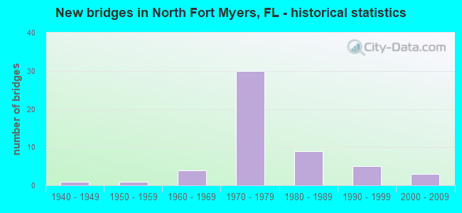
- New bridges - historical statistics
- 11940-1949
- 11950-1959
- 41960-1969
- 301970-1979
- 91980-1989
- 51990-1999
- 32000-2009

- Reconstructed bridges - Historical Statistics
- 11960-1969
- 11970-1979
- 01980-1989
- 01990-1999
- 22000-2009
- 82010-2019


- Bridge Condition - Deck
- 82.6%Good
- 13.0%Satisfactory
- 4.3%Fair

- Bridge Condition - Superstructure
- 91.3%Good
- 4.3%Satisfactory
- 4.3%Fair

- Bridge Condition - Substructure
- 82.6%Good
- 17.4%Satisfactory

- Bridge Condition - Channel
- 2.2%Excellent
- 4.4%Very good
- 77.8%Good
- 15.6%Satisfactory

- Bridge Condition - Culverts
- 76.9%Good
- 23.1%Satisfactory
Find on map >> Show street view
Structure Number: 10064, Location: 1.5 Mi. East of US 41 (Lat: 26.810639, Lng: -81.932028), Route carried "on" structure: County highway , Year Built: 1979, Status: Open, Structure Length: 20.69m (67.88ft), Average Daily Traffic: 3,500 (year 2017), Truck Traffic: 22%, Average Future Daily Traffic: 5,473 (year 2039), Design Load: HS 20+Mod, Features Intersected: I-75 - SCL RR, Facility Carried by Structure: OIL WELL ROAD
Minimum Vertical Clearance: 30+ m (98+ ft), Kilometerpoint: 2.400, Lanes on structure: 2, Lanes under structure: 6, Owner: State Highway Agency, Approaching Roadway Width: 8.3m (27.2ft), Skew: 4 degrees, Material/Design: Steel continuous, Design/Construction: Stringer/Multi-beam, Number Of Spans In Main Unit: 5, Number Of Approach Spans: 1, Length of Maximum Span: 42.7m (140.1ft), Curb-To-Curb Width: 12.1m (39.7ft), Out-to-Out Width: 13.0m (42.7ft)
Condition: Deck: Satisfactory, Superstructure: Good, Substructure: Good, Operating Rating: 75.4 metric tons, Method Used To Determine Operating Rating: Load Factor (LF), Inventory Rating: 45.0 metric tons, Method Used To Determine Inventory Rating: Load Factor (LF), Structural Evaluation: Better than present minimum criteria, Deck Geometry: Somewhat better than minimum adequacy, Underclear: Somewhat better than minimum adequacy, Approach Roadway Alignment: Equal to present desirable criteria, Designated Inspection Frequency: Every 24 months, Inspection Date: April 2021, Deck Structure Type: Concrete Precast Panels
Find on map >> Show street view
Structure Number: 10078, Location: 1.0 MI N OF LEE COUNTY (Lat: 26.778614, Lng: -81.893569), Route carried "on" structure: Interstate 75, Year Built: 1978, Year Reconstructed: 2015, Status: Open, Structure Length: 4.11m (13.48ft), Average Daily Traffic: 24,250 (year 2020), Truck Traffic: 18%, Average Future Daily Traffic: 42,074 (year 2042), Design Load: HL 93, Features Intersected: SANDY HARTMANS CANAL
Minimum Vertical Clearance: 30+ m (98+ ft), Kilometerpoint: 1.714, Lanes on structure: 3, Base Highway Network: Yes, Owner: State Highway Agency, Approaching Roadway Width: 17.1m (56.1ft), Material/Design: Concrete continuous, Design/Construction: Slab, Number Of Spans In Main Unit: 5, Length of Maximum Span: 8.8m (28.9ft), Curb-To-Curb Width: 17.1m (56.1ft), Out-to-Out Width: 18.0m (59.1ft)
Condition: Deck: Good, Superstructure: Good, Substructure: Satisfactory, Channel: Good, Operating Rating: 43.5 metric tons, Method Used To Determine Operating Rating: Load and Resistance Factor (LRFR), Inventory Rating: 33.3 metric tons, Method Used To Determine Inventory Rating: Load and Resistance Factor (LRFR), Structural Evaluation: Equal to present minimum criteria, Deck Geometry: Equal to present minimum criteria, Waterway Adequacy: Superior to present desirable criteria, Approach Roadway Alignment: Equal to present desirable criteria, Designated Inspection Frequency: Every 24 months, Underwater Inspection Frequency: Every 24 months, Inspection Date: April 2021, Underwater Inspection Date: March 2021, Deck Structure Type: Concrete Cast-file-Place
Find on map >> Show street view
Structure Number: 10079, Location: 1.0 MI N OF LEE COUNTY (Lat: 26.779219, Lng: -81.893086), Route carried "on" structure: Interstate 75, Year Built: 1978, Year Reconstructed: 2015, Status: Open, Structure Length: 4.11m (13.48ft), Average Daily Traffic: 24,250 (year 2020), Truck Traffic: 18%, Average Future Daily Traffic: 42,074 (year 2042), Design Load: HL 93, Features Intersected: SANDY HARTMANS CANAL
Minimum Vertical Clearance: 30+ m (98+ ft), Kilometerpoint: 1.714, Lanes on structure: 3, Base Highway Network: Yes, Owner: State Highway Agency, Approaching Roadway Width: 11.6m (38.1ft), Material/Design: Concrete continuous, Design/Construction: Slab, Number Of Spans In Main Unit: 5, Length of Maximum Span: 8.8m (28.9ft), Curb-To-Curb Width: 17.0m (55.8ft), Out-to-Out Width: 18.0m (59.1ft)
Condition: Deck: Good, Superstructure: Good, Substructure: Satisfactory, Channel: Excellent, Operating Rating: 43.5 metric tons, Method Used To Determine Operating Rating: Load and Resistance Factor (LRFR), Inventory Rating: 33.3 metric tons, Method Used To Determine Inventory Rating: Load and Resistance Factor (LRFR), Structural Evaluation: Equal to present minimum criteria, Deck Geometry: Equal to present minimum criteria, Waterway Adequacy: Superior to present desirable criteria, Approach Roadway Alignment: Equal to present desirable criteria, Designated Inspection Frequency: Every 24 months, Underwater Inspection Frequency: Every 24 months, Inspection Date: April 2021, Underwater Inspection Date: March 2021, Deck Structure Type: Concrete Cast-file-Place
Find on map >> Show street view
Structure Number: 120012, Location: 0.2MI N OF US41 BUS INTER (Lat: 26.714358, Lng: -81.903031), Route carried "on" structure: US 41, Year Built: 1962, Year Reconstructed: 1974, Status: Open, Structure Length: 0.64m (2.10ft), Average Daily Traffic: 34,000 (year 2020), Truck Traffic: 7%, Average Future Daily Traffic: 58,990 (year 2042), Design Load: HS 20+Mod, Features Intersected: APEX CREEK
Minimum Vertical Clearance: 30+ m (98+ ft), Kilometerpoint: 46.985, Lanes on structure: 4, Base Highway Network: Yes, Owner: State Highway Agency, Approaching Roadway Width: 23.6m (77.4ft), Skew: 11 degrees, Material/Design: Concrete, Design/Construction: Culvert, Number Of Spans In Main Unit: 2, Length of Maximum Span: 3.0m (9.8ft)
Condition: Channel: Good, Culverts: Good, Inventory Rating: 65.3 metric tons, Method Used To Determine Inventory Rating: Load Factor (LF), Structural Evaluation: Better than present minimum criteria, Waterway Adequacy: Equal to present desirable criteria, Approach Roadway Alignment: Equal to present desirable criteria, Designated Inspection Frequency: Every 24 months, Underwater Inspection Frequency: Every 23 months, Inspection Date: July 2020, Underwater Inspection Date: July 2020
Find on map >> Show street view
Structure Number: 120075, Location: 1.7 MI E of BUS 41 (Lat: 26.692153, Lng: -81.857519), Route carried "on" structure: State highway 78, Year Built: 1957, Status: Open, Structure Length: 0.88m (2.89ft), Average Daily Traffic: 36,500 (year 2021), Truck Traffic: 11%, Average Future Daily Traffic: 63,328 (year 2042), Design Load: H 15, Features Intersected: INDIAN CREEK
Minimum Vertical Clearance: 30+ m (98+ ft), Kilometerpoint: 28.217, Lanes on structure: 4, Base Highway Network: Yes, Owner: State Highway Agency, Approaching Roadway Width: 18.1m (59.4ft), Skew: 19 degrees, Material/Design: Concrete, Design/Construction: Culvert, Number Of Spans In Main Unit: 2, Length of Maximum Span: 4.4m (14.4ft)
Condition: Channel: Good, Culverts: Good, Operating Rating: 80.0 metric tons, Method Used To Determine Operating Rating: Load Factor (LF), Inventory Rating: 48.0 metric tons, Method Used To Determine Inventory Rating: Load Factor (LF), Structural Evaluation: Better than present minimum criteria, Waterway Adequacy: Equal to present desirable criteria, Approach Roadway Alignment: Better than present minimum criteria, Designated Inspection Frequency: Every 24 months, Inspection Date: December 2021
Find on map >> Show street view
Structure Number: 120081, Location: 1 Mi. S of SR-78 (Lat: 26.705058, Lng: -81.804042), Route carried "on" structure: Interstate 75, Year Built: 1977, Year Reconstructed: 2015, Status: Open, Structure Length: 4.10m (13.45ft), Average Daily Traffic: 35,000 (year 2020), Truck Traffic: 14%, Average Future Daily Traffic: 60,725 (year 2042), Design Load: HL 93, Features Intersected: TIDAL CREEK
Minimum Vertical Clearance: 30+ m (98+ ft), Kilometerpoint: 44.288, Lanes on structure: 4, Base Highway Network: Yes, Owner: State Highway Agency, Approaching Roadway Width: 20.7m (67.9ft), Skew: 1 degrees, Material/Design: Prestressed concrete, Design/Construction: Stringer/Multi-beam, Number Of Spans In Main Unit: 3, Length of Maximum Span: 13.7m (44.9ft), Curb-To-Curb Width: 20.7m (67.9ft), Out-to-Out Width: 21.6m (70.9ft)
Condition: Deck: Good, Superstructure: Good, Substructure: Good, Channel: Good, Operating Rating: 48.4 metric tons, Method Used To Determine Operating Rating: Load and Resistance Factor (LRFR), Inventory Rating: 37.6 metric tons, Method Used To Determine Inventory Rating: Load and Resistance Factor (LRFR), Structural Evaluation: Better than present minimum criteria, Deck Geometry: Equal to present minimum criteria, Waterway Adequacy: Equal to present desirable criteria, Approach Roadway Alignment: Equal to present desirable criteria, Designated Inspection Frequency: Every 24 months, Underwater Inspection Frequency: Every 24 months, Inspection Date: May 2020, Underwater Inspection Date: April 2020, Deck Structure Type: Concrete Cast-file-Place
Find on map >> Show street view
Structure Number: 120082, Location: 1.0MI SOUTH OF SR-78 (Lat: 26.705281, Lng: -81.803769), Route carried "on" structure: Interstate 75, Year Built: 1977, Year Reconstructed: 2015, Status: Open, Structure Length: 4.36m (14.30ft), Average Daily Traffic: 35,000 (year 2020), Truck Traffic: 14%, Average Future Daily Traffic: 60,725 (year 2042), Design Load: HL 93, Features Intersected: TIDAL CREEK
Minimum Vertical Clearance: 30+ m (98+ ft), Kilometerpoint: 44.294, Lanes on structure: 4, Base Highway Network: Yes, Owner: State Highway Agency, Approaching Roadway Width: 20.7m (67.9ft), Material/Design: Prestressed concrete, Design/Construction: Stringer/Multi-beam, Number Of Spans In Main Unit: 3, Length of Maximum Span: 15.2m (49.9ft), Curb-To-Curb Width: 20.7m (67.9ft), Out-to-Out Width: 21.6m (70.9ft)
Condition: Deck: Good, Superstructure: Good, Substructure: Good, Channel: Good, Operating Rating: 46.7 metric tons, Method Used To Determine Operating Rating: Load and Resistance Factor (LRFR), Inventory Rating: 35.6 metric tons, Method Used To Determine Inventory Rating: Load and Resistance Factor (LRFR), Structural Evaluation: Better than present minimum criteria, Deck Geometry: Equal to present minimum criteria, Waterway Adequacy: Equal to present desirable criteria, Approach Roadway Alignment: Equal to present desirable criteria, Designated Inspection Frequency: Every 24 months, Underwater Inspection Frequency: Every 24 months, Inspection Date: May 2020, Underwater Inspection Date: April 2020, Deck Structure Type: Concrete Cast-file-Place
Find on map >> Show street view
Structure Number: 120098, Location: 3.9Mi N of SR-78 (Lat: 26.737094, Lng: -81.913217), Route carried "on" structure: US 41, Year Built: 1942, Year Reconstructed: 1975, Status: Open, Structure Length: 0.68m (2.23ft), Average Daily Traffic: 29,000 (year 2020), Truck Traffic: 9%, Average Future Daily Traffic: 50,315 (year 2042), Design Load: HS 20+Mod, Features Intersected: GATOR SLOUGH RELIEF
Minimum Vertical Clearance: 30+ m (98+ ft), Kilometerpoint: 49.714, Lanes on structure: 4, Base Highway Network: Yes, Owner: State Highway Agency, Approaching Roadway Width: 22.9m (75.1ft), Skew: 10 degrees, Material/Design: Concrete, Design/Construction: Culvert, Number Of Spans In Main Unit: 2, Length of Maximum Span: 3.4m (11.2ft)
Condition: Channel: Good, Culverts: Good, Inventory Rating: 65.3 metric tons, Method Used To Determine Inventory Rating: Load Factor (LF), Structural Evaluation: Better than present minimum criteria, Waterway Adequacy: Better than present minimum criteria, Approach Roadway Alignment: Equal to present desirable criteria, Designated Inspection Frequency: Every 24 months, Underwater Inspection Frequency: Every 24 months, Inspection Date: July 2020, Underwater Inspection Date: June 2020
Find on map >> Show street view
Structure Number: 120099, Location: 4.5Mi N of SR 78 (Lat: 26.743911, Lng: -81.916917), Route carried "on" structure: US 41, Year Built: 1975, Status: Open, Structure Length: 1.30m (4.27ft), Average Daily Traffic: 29,000 (year 2020), Truck Traffic: 9%, Average Future Daily Traffic: 50,315 (year 2042), Design Load: HS 20+Mod, Features Intersected: GATOR SLOUGH CANAL
Minimum Vertical Clearance: 30+ m (98+ ft), Kilometerpoint: 50.553, Lanes on structure: 4, Base Highway Network: Yes, Owner: State Highway Agency, Approaching Roadway Width: 17.7m (58.1ft), Skew: 10 degrees, Material/Design: Concrete, Design/Construction: Culvert, Number Of Spans In Main Unit: 4, Length of Maximum Span: 3.3m (10.8ft)
Condition: Channel: Good, Culverts: Good, Operating Rating: 61.0 metric tons, Method Used To Determine Operating Rating: Load Factor (LF), Inventory Rating: 36.6 metric tons, Method Used To Determine Inventory Rating: Load Factor (LF), Structural Evaluation: Better than present minimum criteria, Waterway Adequacy: Equal to present desirable criteria, Approach Roadway Alignment: Equal to present desirable criteria, Designated Inspection Frequency: Every 24 months, Inspection Date: July 2020
Find on map >> Show street view
Structure Number: 1201, Location: 0.1Mi. S of SR-78 (Lat: 26.711642, Lng: -81.809225), Route carried "on" structure: Interstate 75, Year Built: 1978, Year Reconstructed: 2015, Status: Open, Structure Length: 12.37m (40.58ft), Average Daily Traffic: 35,000 (year 2020), Truck Traffic: 14%, Average Future Daily Traffic: 60,725 (year 2042), Design Load: HL 93, Features Intersected: POPASH CREEK
Minimum Vertical Clearance: 30+ m (98+ ft), Kilometerpoint: 45.136, Lanes on structure: 3, Base Highway Network: Yes, Owner: State Highway Agency, Approaching Roadway Width: 21.3m (69.9ft), Skew: 2 degrees, Material/Design: Concrete continuous, Design/Construction: Slab, Number Of Spans In Main Unit: 13, Length of Maximum Span: 9.8m (32.2ft), Curb-To-Curb Width: 24.1m (79.1ft), Out-to-Out Width: 24.6m (80.7ft)
Condition: Deck: Good, Superstructure: Good, Substructure: Satisfactory, Channel: Satisfactory, Operating Rating: 49.0 metric tons, Method Used To Determine Operating Rating: Load and Resistance Factor (LRFR), Inventory Rating: 37.9 metric tons, Method Used To Determine Inventory Rating: Load and Resistance Factor (LRFR), Structural Evaluation: Equal to present minimum criteria, Deck Geometry: Superior to present desirable criteria, Waterway Adequacy: Equal to present desirable criteria, Approach Roadway Alignment: Equal to present desirable criteria, Designated Inspection Frequency: Every 24 months, Underwater Inspection Frequency: Every 24 months, Inspection Date: May 2020, Underwater Inspection Date: April 2020, Deck Structure Type: Concrete Cast-file-Place
Find on map >> Show street view
Structure Number: 120101, Location: 0.1MI SOUTH OF SR-78 (Lat: 26.711711, Lng: -81.808833), Route carried "on" structure: Interstate 75, Year Built: 1978, Year Reconstructed: 2015, Status: Open, Structure Length: 5.55m (18.21ft), Average Daily Traffic: 35,000 (year 2020), Truck Traffic: 14%, Average Future Daily Traffic: 60,725 (year 2042), Design Load: HL 93, Features Intersected: POPASH CREEK
Minimum Vertical Clearance: 30+ m (98+ ft), Kilometerpoint: 45.147, Lanes on structure: 3, Base Highway Network: Yes, Owner: State Highway Agency, Approaching Roadway Width: 21.3m (69.9ft), Skew: 2 degrees, Material/Design: Concrete continuous, Design/Construction: Slab, Number Of Spans In Main Unit: 6, Length of Maximum Span: 9.8m (32.2ft), Curb-To-Curb Width: 26.5m (86.9ft), Out-to-Out Width: 27.6m (90.6ft)
Condition: Deck: Good, Superstructure: Good, Substructure: Good, Channel: Good, Operating Rating: 46.1 metric tons, Method Used To Determine Operating Rating: Load and Resistance Factor (LRFR), Inventory Rating: 35.6 metric tons, Method Used To Determine Inventory Rating: Load and Resistance Factor (LRFR), Structural Evaluation: Better than present minimum criteria, Deck Geometry: Superior to present desirable criteria, Waterway Adequacy: Equal to present desirable criteria, Approach Roadway Alignment: Equal to present desirable criteria, Designated Inspection Frequency: Every 24 months, Underwater Inspection Frequency: Every 24 months, Inspection Date: May 2020, Underwater Inspection Date: April 2020, Deck Structure Type: Concrete Cast-file-Place
Find on map >> Show street view
Structure Number: 120102, Location: 0.6Mi. South of SR-78 (Lat: 26.708075, Lng: -81.806464), Route carried "on" structure: Interstate 75, Year Built: 1978, Year Reconstructed: 2015, Status: Open, Structure Length: 28.96m (95.01ft), Average Daily Traffic: 35,000 (year 2020), Truck Traffic: 14%, Average Future Daily Traffic: 60,725 (year 2042), Design Load: HL 93, Features Intersected: TIDAL MARSH
Minimum Vertical Clearance: 30+ m (98+ ft), Kilometerpoint: 44.579, Lanes on structure: 4, Base Highway Network: Yes, Owner: State Highway Agency, Approaching Roadway Width: 20.8m (68.2ft), Material/Design: Prestressed concrete, Design/Construction: Stringer/Multi-beam, Number Of Spans In Main Unit: 21, Length of Maximum Span: 13.8m (45.3ft), Curb-To-Curb Width: 20.8m (68.2ft), Out-to-Out Width: 21.7m (71.2ft)
Condition: Deck: Good, Superstructure: Good, Substructure: Satisfactory, Channel: Good, Operating Rating: 44.1 metric tons, Method Used To Determine Operating Rating: Load and Resistance Factor (LRFR), Inventory Rating: 33.7 metric tons, Method Used To Determine Inventory Rating: Load and Resistance Factor (LRFR), Structural Evaluation: Equal to present minimum criteria, Deck Geometry: Equal to present minimum criteria, Waterway Adequacy: Equal to present desirable criteria, Approach Roadway Alignment: Equal to present desirable criteria, Designated Inspection Frequency: Every 24 months, Inspection Date: May 2020, Deck Structure Type: Concrete Cast-file-Place
Find on map >> Show street view
Structure Number: 120103, Location: 0.6MI SOUTH OF SR-78 (Lat: 26.708244, Lng: -81.806114), Route carried "on" structure: Interstate 75, Year Built: 1978, Year Reconstructed: 2015, Status: Open, Structure Length: 28.96m (95.01ft), Average Daily Traffic: 35,000 (year 2020), Truck Traffic: 14%, Average Future Daily Traffic: 60,725 (year 2042), Design Load: HL 93, Features Intersected: TIDAL MARSH
Minimum Vertical Clearance: 30+ m (98+ ft), Kilometerpoint: 44.580, Lanes on structure: 2, Base Highway Network: Yes, Owner: State Highway Agency, Approaching Roadway Width: 20.8m (68.2ft), Material/Design: Prestressed concrete, Design/Construction: Stringer/Multi-beam, Number Of Spans In Main Unit: 21, Length of Maximum Span: 13.8m (45.3ft), Curb-To-Curb Width: 20.8m (68.2ft), Out-to-Out Width: 21.7m (71.2ft)
Condition: Deck: Good, Superstructure: Good, Substructure: Good, Channel: Good, Operating Rating: 44.1 metric tons, Method Used To Determine Operating Rating: Load and Resistance Factor (LRFR), Inventory Rating: 33.7 metric tons, Method Used To Determine Inventory Rating: Load and Resistance Factor (LRFR), Structural Evaluation: Better than present minimum criteria, Deck Geometry: Superior to present desirable criteria, Waterway Adequacy: Equal to present desirable criteria, Approach Roadway Alignment: Equal to present desirable criteria, Designated Inspection Frequency: Every 24 months, Inspection Date: May 2020, Deck Structure Type: Concrete Cast-file-Place
Find on map >> Show street view
Structure Number: 120112, Location: 1.5MI N/O Caloosahatchee (Lat: 26.715031, Lng: -81.811911), Route carried "on" structure: Interstate 75, Year Built: 1979, Year Reconstructed: 2014, Status: Open, Structure Length: 6.61m (21.69ft), Average Daily Traffic: 35,000 (year 2020), Truck Traffic: 14%, Average Future Daily Traffic: 60,725 (year 2042), Design Load: HL 93, Features Intersected: SR-78 (BAYSHORE RD.)
Minimum Vertical Clearance: 30.45m (99.90ft), Kilometerpoint: 45.622, Lanes on structure: 3, Lanes under structure: 4, Base Highway Network: Yes, Owner: State Highway Agency, Approaching Roadway Width: 16.9m (55.4ft), Skew: 3 degrees, Material/Design: Steel, Design/Construction: Stringer/Multi-beam, Number Of Spans In Main Unit: 3, Length of Maximum Span: 39.0m (128.0ft), Curb-To-Curb Width: 16.9m (55.4ft), Out-to-Out Width: 17.9m (58.7ft)
Condition: Deck: Good, Superstructure: Good, Substructure: Good, Operating Rating: 57.8 metric tons, Method Used To Determine Operating Rating: Load and Resistance Factor (LRFR), Inventory Rating: 43.5 metric tons, Method Used To Determine Inventory Rating: Load and Resistance Factor (LRFR), Structural Evaluation: Better than present minimum criteria, Deck Geometry: Equal to present minimum criteria, Underclear: Equal to present minimum criteria, Approach Roadway Alignment: Equal to present desirable criteria, Designated Inspection Frequency: Every 24 months, Inspection Date: May 2020, Deck Structure Type: Concrete Cast-file-Place
Find on map >> Show street view
Structure Number: 120113, Location: 1.5MI N/O Caloosahatche (Lat: 26.715050, Lng: -81.811553), Route carried "on" structure: Interstate 75, Year Built: 1979, Year Reconstructed: 2014, Status: Open, Structure Length: 6.61m (21.69ft), Average Daily Traffic: 35,000 (year 2020), Truck Traffic: 14%, Average Future Daily Traffic: 60,725 (year 2042), Design Load: HL 93, Features Intersected: SR-78 (BAYSHORE RD.)
Minimum Vertical Clearance: 30+ m (98+ ft), Kilometerpoint: 45.601, Lanes on structure: 3, Lanes under structure: 4, Base Highway Network: Yes, Owner: State Highway Agency, Approaching Roadway Width: 16.9m (55.4ft), Skew: 3 degrees, Material/Design: Steel, Design/Construction: Stringer/Multi-beam, Number Of Spans In Main Unit: 3, Length of Maximum Span: 39.0m (128.0ft), Curb-To-Curb Width: 16.9m (55.4ft), Out-to-Out Width: 17.9m (58.7ft)
Condition: Deck: Good, Superstructure: Good, Substructure: Good, Operating Rating: 57.8 metric tons, Method Used To Determine Operating Rating: Load and Resistance Factor (LRFR), Inventory Rating: 43.5 metric tons, Method Used To Determine Inventory Rating: Load and Resistance Factor (LRFR), Structural Evaluation: Better than present minimum criteria, Deck Geometry: Equal to present minimum criteria, Underclear: Equal to present minimum criteria, Approach Roadway Alignment: Equal to present desirable criteria, Designated Inspection Frequency: Every 24 months, Inspection Date: May 2020, Deck Structure Type: Concrete Cast-file-Place
Find on map >> Show street view
Structure Number: 120114, Location: 2.9 Mi. N of SR-78 (Lat: 26.739731, Lng: -81.850594), Route carried "on" structure: County highway , Year Built: 1979, Status: Open, Structure Length: 18.94m (62.14ft), Average Daily Traffic: 2,200 (year 2021), Truck Traffic: 13%, Average Future Daily Traffic: 3,817 (year 2041), Design Load: HS 20, Features Intersected: I-75 (SR-93), Facility Carried by Structure: SLATER ROAD
Minimum Vertical Clearance: 30+ m (98+ ft), Kilometerpoint: 1.315, Lanes on structure: 2, Lanes under structure: 6, Owner: State Highway Agency, Approaching Roadway Width: 12.6m (41.3ft), Skew: 3 degrees, Material/Design: Steel continuous, Design/Construction: Stringer/Multi-beam, Number Of Spans In Main Unit: 4, Length of Maximum Span: 47.5m (155.8ft), Curb-To-Curb Width: 12.2m (40.0ft), Out-to-Out Width: 13.0m (42.7ft)
Condition: Deck: Satisfactory, Superstructure: Good, Substructure: Good, Operating Rating: 56.2 metric tons, Method Used To Determine Operating Rating: Load Factor (LF), Inventory Rating: 33.6 metric tons, Method Used To Determine Inventory Rating: Load Factor (LF), Structural Evaluation: Better than present minimum criteria, Deck Geometry: Equal to present minimum criteria, Underclear: Equal to present minimum criteria, Approach Roadway Alignment: Equal to present desirable criteria, Designated Inspection Frequency: Every 24 months, Inspection Date: June 2021, Deck Structure Type: Concrete Precast Panels
Find on map >> Show street view
Structure Number: 120115, Location: 0.1MI NORTH OF SR-78 (Lat: 26.715661, Lng: -81.808583), Route carried "on" structure: County highway , Year Built: 1978, Status: Open, Structure Length: 4.28m (14.04ft), Average Daily Traffic: 2,000 (year 2021), Truck Traffic: 2%, Average Future Daily Traffic: 2,100 (year 2041), Design Load: HS 20, Features Intersected: POPASH CREEK, Facility Carried by Structure: FRONTAGE RD
Minimum Vertical Clearance: 30+ m (98+ ft), Kilometerpoint: 0.000, Lanes on structure: 2, Owner: County Highway Agency, Approaching Roadway Width: 11.4m (37.4ft), Skew: 1 degrees, Material/Design: Concrete continuous, Design/Construction: Slab, Number Of Spans In Main Unit: 5, Length of Maximum Span: 9.1m (29.9ft), Curb-To-Curb Width: 11.4m (37.4ft), Out-to-Out Width: 12.2m (40.0ft)
Condition: Deck: Good, Superstructure: Good, Substructure: Good, Channel: Good, Operating Rating: 52.4 metric tons, Method Used To Determine Operating Rating: Load and Resistance Factor (LRFR), Inventory Rating: 40.5 metric tons, Method Used To Determine Inventory Rating: Load and Resistance Factor (LRFR), Structural Evaluation: Better than present minimum criteria, Deck Geometry: Equal to present minimum criteria, Waterway Adequacy: Better than present minimum criteria, Approach Roadway Alignment: Better than present minimum criteria, Designated Inspection Frequency: Every 24 months, Inspection Date: July 2021, Deck Structure Type: Concrete Cast-file-Place
Find on map >> Show street view
Structure Number: 120117, Location: 0.19MI E of I 75 (Lat: 26.714961, Lng: -81.808403), Route carried "on" structure: State highway 78, Year Built: 1979, Status: Open, Structure Length: 5.20m (17.06ft), Average Daily Traffic: 14,300 (year 2021), Truck Traffic: 16%, Average Future Daily Traffic: 24,810 (year 2041), Design Load: HS 20+Mod, Features Intersected: POPASH CREEK
Minimum Vertical Clearance: 30+ m (98+ ft), Kilometerpoint: 34.289, Lanes on structure: 5, Owner: State Highway Agency, Approaching Roadway Width: 24.5m (80.4ft), Skew: 20 degrees, Material/Design: Concrete continuous, Design/Construction: Slab, Number Of Spans In Main Unit: 6, Length of Maximum Span: 9.1m (29.9ft), Curb or Sidewalk Widths: Left: 1.5m (4.9ft), Right: 1.5m (4.9ft), Curb-To-Curb Width: 24.5m (80.4ft), Out-to-Out Width: 32.3m (106.0ft)
Condition: Deck: Satisfactory, Superstructure: Satisfactory, Substructure: Good, Channel: Good, Operating Rating: 76.3 metric tons, Method Used To Determine Operating Rating: Load Factor (LF), Inventory Rating: 45.6 metric tons, Method Used To Determine Inventory Rating: Load Factor (LF), Structural Evaluation: Equal to present minimum criteria, Deck Geometry: Superior to present desirable criteria, Waterway Adequacy: Equal to present desirable criteria, Approach Roadway Alignment: Equal to present desirable criteria, Designated Inspection Frequency: Every 24 months, Inspection Date: December 2021, Deck Structure Type: Concrete Cast-file-Place
Find on map >> Show street view
Structure Number: 120132, Location: 3.5 MI NORTH OF SR 78 (Lat: 26.742417, Lng: -81.854083), Route carried "on" structure: Interstate 75, Year Built: 1979, Status: Open, Structure Length: 1.37m (4.49ft), Average Daily Traffic: 50,000 (year 2021), Truck Traffic: 16%, Average Future Daily Traffic: 86,750 (year 2041), Design Load: HS 20+Mod, Features Intersected: DAUGHTREY CREEK OVERFLOW
Minimum Vertical Clearance: 30+ m (98+ ft), Kilometerpoint: 50.984, Lanes on structure: 6, Base Highway Network: Yes, Owner: State Highway Agency, Approaching Roadway Width: 36.3m (119.1ft), Skew: 4 degrees, Material/Design: Concrete, Design/Construction: Culvert, Number Of Spans In Main Unit: 3, Length of Maximum Span: 4.6m (15.1ft)
Condition: Channel: Good, Culverts: Good, Inventory Rating: 60.5 metric tons, Method Used To Determine Inventory Rating: Load Factor (LF), Structural Evaluation: Better than present minimum criteria, Waterway Adequacy: Equal to present desirable criteria, Approach Roadway Alignment: Equal to present desirable criteria, Designated Inspection Frequency: Every 24 months, Inspection Date: April 2021
Find on map >> Show street view
Structure Number: 120133, Location: 3.7 MI N of SR 78 (Lat: 26.744308, Lng: -81.855850), Route carried "on" structure: Interstate 75, Year Built: 1979, Status: Open, Structure Length: 1.07m (3.51ft), Average Daily Traffic: 50,000 (year 2021), Truck Traffic: 16%, Average Future Daily Traffic: 86,750 (year 2041), Design Load: HS 20+Mod, Features Intersected: DAUGHTREY CREEK
Minimum Vertical Clearance: 30+ m (98+ ft), Kilometerpoint: 51.213, Lanes on structure: 6, Base Highway Network: Yes, Owner: State Highway Agency, Approaching Roadway Width: 35.5m (116.5ft), Skew: 2 degrees, Material/Design: Concrete, Design/Construction: Culvert, Number Of Spans In Main Unit: 3, Length of Maximum Span: 3.7m (12.1ft)
Condition: Channel: Good, Culverts: Satisfactory, Inventory Rating: 60.5 metric tons, Method Used To Determine Inventory Rating: Load Factor (LF), Structural Evaluation: Equal to present minimum criteria, Waterway Adequacy: Equal to present desirable criteria, Approach Roadway Alignment: Equal to present desirable criteria, Designated Inspection Frequency: Every 24 months, Inspection Date: April 2021
Find on map >> Show street view
Structure Number: 120134, Location: 1.4MI. S OF COUNTY LINE (Lat: 26.753203, Lng: -81.866036), Route carried "on" structure: Interstate 75, Year Built: 1980, Status: Open, Structure Length: 0.75m (2.46ft), Average Daily Traffic: 50,000 (year 2021), Truck Traffic: 16%, Average Future Daily Traffic: 86,750 (year 2041), Design Load: HS 20+Mod, Features Intersected: LOST CREEK
Minimum Vertical Clearance: 30+ m (98+ ft), Kilometerpoint: 52.632, Lanes on structure: 6, Base Highway Network: Yes (Inventory Route: 120750, Subroute: 20), Owner: State Highway Agency, Approaching Roadway Width: 35.4m (116.1ft), Skew: 3 degrees, Material/Design: Concrete, Design/Construction: Culvert, Number Of Spans In Main Unit: 2, Length of Maximum Span: 3.3m (10.8ft)
Condition: Channel: Good, Culverts: Satisfactory, Inventory Rating: 69.0 metric tons, Method Used To Determine Inventory Rating: Load Factor (LF), Structural Evaluation: Equal to present minimum criteria, Waterway Adequacy: Equal to present desirable criteria, Approach Roadway Alignment: Equal to present desirable criteria, Designated Inspection Frequency: Every 24 months, Underwater Inspection Frequency: Every 24 months, Inspection Date: May 2021, Underwater Inspection Date: May 2021
Find on map >> Show street view
Structure Number: 120135, Location: 5.2MI NORTH OF SR-78 (Lat: 26.765564, Lng: -81.875742), Route carried "on" structure: Interstate 75, Year Built: 1979, Status: Open, Structure Length: 1.04m (3.41ft), Average Daily Traffic: 25,000 (year 2021), Truck Traffic: 16%, Average Future Daily Traffic: 43,375 (year 2041), Design Load: HS 20+Mod, Features Intersected: GILCHREST CANAL
Minimum Vertical Clearance: 30+ m (98+ ft), Kilometerpoint: 54.327, Lanes on structure: 2, Base Highway Network: Yes, Owner: State Highway Agency, Approaching Roadway Width: 17.8m (58.4ft), Skew: 3 degrees, Material/Design: Concrete, Design/Construction: Culvert, Number Of Spans In Main Unit: 3, Length of Maximum Span: 3.6m (11.8ft)
Condition: Channel: Satisfactory, Culverts: Satisfactory, Operating Rating: 85.0 metric tons, Method Used To Determine Operating Rating: Load Factor (LF), Inventory Rating: 51.0 metric tons, Method Used To Determine Inventory Rating: Load Factor (LF), Structural Evaluation: Equal to present minimum criteria, Waterway Adequacy: Equal to present desirable criteria, Approach Roadway Alignment: Equal to present desirable criteria, Designated Inspection Frequency: Every 24 months, Underwater Inspection Frequency: Every 24 months, Inspection Date: May 2021, Underwater Inspection Date: May 2021
Find on map >> Show street view
Structure Number: 120136, Location: 0.4mi. S OF CHARLOTTE CO. (Lat: 26.765117, Lng: -81.876239), Route carried "on" structure: Interstate 75, Year Built: 1979, Status: Open, Structure Length: 1.04m (3.41ft), Average Daily Traffic: 25,000 (year 2021), Truck Traffic: 16%, Average Future Daily Traffic: 43,375 (year 2041), Design Load: HS 20+Mod, Features Intersected: GILCHREST CANAL
Minimum Vertical Clearance: 30+ m (98+ ft), Kilometerpoint: 54.323, Lanes on structure: 3, Base Highway Network: Yes, Owner: State Highway Agency, Approaching Roadway Width: 17.9m (58.7ft), Skew: 3 degrees, Material/Design: Concrete, Design/Construction: Culvert, Number Of Spans In Main Unit: 3, Length of Maximum Span: 3.3m (10.8ft)
Condition: Channel: Good, Culverts: Satisfactory, Operating Rating: 85.0 metric tons, Method Used To Determine Operating Rating: Load Factor (LF), Inventory Rating: 51.0 metric tons, Method Used To Determine Inventory Rating: Load Factor (LF), Structural Evaluation: Equal to present minimum criteria, Waterway Adequacy: Equal to present desirable criteria, Approach Roadway Alignment: Equal to present desirable criteria, Designated Inspection Frequency: Every 24 months, Underwater Inspection Frequency: Every 24 months, Inspection Date: May 2021, Underwater Inspection Date: May 2021
Find on map >> Show street view
Structure Number: 120137, Location: 1.6MI. N OF SR-78 (Lat: 26.724903, Lng: -81.833383), Route carried "on" structure: Interstate 75, Year Built: 1979, Status: Open, Structure Length: 0.76m (2.49ft), Average Daily Traffic: 25,000 (year 2021), Truck Traffic: 16%, Average Future Daily Traffic: 43,375 (year 2041), Design Load: HS 20+Mod, Features Intersected: LEE CREEK
Minimum Vertical Clearance: 30+ m (98+ ft), Kilometerpoint: 48.182, Lanes on structure: 2, Base Highway Network: Yes, Owner: State Highway Agency, Approaching Roadway Width: 18.0m (59.1ft), Skew: 5 degrees, Material/Design: Concrete, Design/Construction: Culvert, Number Of Spans In Main Unit: 2, Length of Maximum Span: 3.8m (12.5ft)
Condition: Channel: Good, Culverts: Good, Structural Evaluation: Better than present minimum criteria, Waterway Adequacy: Equal to present desirable criteria, Approach Roadway Alignment: Equal to present desirable criteria, Designated Inspection Frequency: Every 24 months, Inspection Date: May 2021
Find on map >> Show street view
Structure Number: 120138, Location: 1.6MI. N OF SR-78 (Lat: 26.726425, Lng: -81.833942), Route carried "on" structure: Interstate 75, Year Built: 1979, Status: Open, Structure Length: 0.78m (2.56ft), Average Daily Traffic: 25,000 (year 2021), Truck Traffic: 16%, Average Future Daily Traffic: 43,375 (year 2041), Design Load: HS 20+Mod, Features Intersected: LEE CREEK
Minimum Vertical Clearance: 30+ m (98+ ft), Kilometerpoint: 48.279, Lanes on structure: 3, Base Highway Network: Yes, Owner: State Highway Agency, Approaching Roadway Width: 17.7m (58.1ft), Skew: 4 degrees, Material/Design: Concrete, Design/Construction: Culvert, Number Of Spans In Main Unit: 2, Length of Maximum Span: 3.2m (10.5ft)
Condition: Channel: Good, Culverts: Good, Inventory Rating: 76.9 metric tons, Method Used To Determine Inventory Rating: Load Factor (LF), Structural Evaluation: Better than present minimum criteria, Waterway Adequacy: Equal to present desirable criteria, Approach Roadway Alignment: Equal to present desirable criteria, Designated Inspection Frequency: Every 24 months, Inspection Date: May 2021
Find on map >> Show street view
Structure Number: 120139, Location: 2.4MI. N OF SR-78 (Lat: 26.733503, Lng: -81.843519), Route carried "on" structure: Interstate 75, Year Built: 1979, Status: Open, Structure Length: 1.18m (3.87ft), Average Daily Traffic: 47,000 (year 2018), Truck Traffic: 16%, Average Future Daily Traffic: 81,545 (year 2040), Design Load: HS 20+Mod, Features Intersected: BAYSHORE CREEK
Minimum Vertical Clearance: 30+ m (98+ ft), Kilometerpoint: 49.508, Lanes on structure: 6, Base Highway Network: Yes, Owner: State Highway Agency, Approaching Roadway Width: 35.8m (117.5ft), Skew: 24 degrees, Material/Design: Concrete, Design/Construction: Culvert, Number Of Spans In Main Unit: 3, Length of Maximum Span: 3.3m (10.8ft)
Condition: Channel: Good, Culverts: Good, Inventory Rating: 61.6 metric tons, Method Used To Determine Inventory Rating: Load Factor (LF), Structural Evaluation: Better than present minimum criteria, Waterway Adequacy: Equal to present desirable criteria, Approach Roadway Alignment: Equal to present desirable criteria, Designated Inspection Frequency: Every 24 months, Underwater Inspection Frequency: Every 24 months, Inspection Date: May 2021, Underwater Inspection Date: May 2021
Find on map >> Show street view
Structure Number: 120161, Location: 0.3 MI E of BUS 41 (Lat: 26.682906, Lng: -81.877386), Route carried "on" structure: State highway 78, Year Built: 1987, Status: Open, Structure Length: 0.94m (3.08ft), Average Daily Traffic: 36,000 (year 2021), Truck Traffic: 7%, Average Future Daily Traffic: 62,460 (year 2042), Design Load: HS 20+Mod, Features Intersected: POWELL CREEK
Minimum Vertical Clearance: 30+ m (98+ ft), Kilometerpoint: 26.141, Lanes on structure: 6, Base Highway Network: Yes, Owner: State Highway Agency, Approaching Roadway Width: 25.8m (84.6ft), Skew: 1 degrees, Material/Design: Concrete, Design/Construction: Culvert, Number Of Spans In Main Unit: 3, Length of Maximum Span: 3.3m (10.8ft)
Condition: Channel: Good, Culverts: Good, Operating Rating: 63.0 metric tons, Method Used To Determine Operating Rating: Load Factor (LF), Inventory Rating: 37.7 metric tons, Method Used To Determine Inventory Rating: Load Factor (LF), Structural Evaluation: Better than present minimum criteria, Waterway Adequacy: Equal to present desirable criteria, Approach Roadway Alignment: Equal to present desirable criteria, Designated Inspection Frequency: Every 24 months, Inspection Date: December 2021
Find on map >> Show street view
Structure Number: 120163, Location: 0.5 MI E of BUS 41 (Lat: 26.683444, Lng: -81.874894), Route carried "on" structure: State highway 78, Year Built: 1987, Status: Open, Structure Length: 0.96m (3.15ft), Average Daily Traffic: 36,000 (year 2021), Truck Traffic: 7%, Average Future Daily Traffic: 62,460 (year 2041), Design Load: HS 20+Mod, Features Intersected: MARTIN CANAL
Minimum Vertical Clearance: 30+ m (98+ ft), Kilometerpoint: 26.393, Lanes on structure: 5, Base Highway Network: Yes, Owner: State Highway Agency, Approaching Roadway Width: 21.0m (68.9ft), Skew: 1 degrees, Material/Design: Concrete, Design/Construction: Culvert, Number Of Spans In Main Unit: 3, Length of Maximum Span: 3.4m (11.2ft), Curb or Sidewalk Widths: Left: 2.5m (8.2ft), Right: 0.0m
Condition: Channel: Good, Culverts: Good, Operating Rating: 65.1 metric tons, Method Used To Determine Operating Rating: Load Factor (LF), Inventory Rating: 39.1 metric tons, Method Used To Determine Inventory Rating: Load Factor (LF), Structural Evaluation: Better than present minimum criteria, Waterway Adequacy: Equal to present desirable criteria, Approach Roadway Alignment: Equal to present desirable criteria, Designated Inspection Frequency: Every 24 months, Inspection Date: December 2021
Find on map >> Show street view
Structure Number: 120166, Location: 0.5MI EAST OF I-75 (Lat: 26.714967, Lng: -81.799792), Route carried "on" structure: State highway 78, Year Built: 1995, Status: Open, Structure Length: 3.37m (11.06ft), Average Daily Traffic: 14,300 (year 2021), Truck Traffic: 16%, Average Future Daily Traffic: 24,810 (year 2042), Design Load: HS 20, Features Intersected: STROUD CREEK
Minimum Vertical Clearance: 30+ m (98+ ft), Kilometerpoint: 35.150, Lanes on structure: 2, Owner: State Highway Agency, Approaching Roadway Width: 11.8m (38.7ft), Material/Design: Concrete continuous, Design/Construction: Slab, Number Of Spans In Main Unit: 3, Length of Maximum Span: 12.8m (42.0ft), Curb-To-Curb Width: 13.4m (44.0ft), Out-to-Out Width: 14.3m (46.9ft)
Condition: Deck: Good, Superstructure: Good, Substructure: Good, Channel: Very good, Operating Rating: 44.3 metric tons, Method Used To Determine Operating Rating: Load Factor (LF), Inventory Rating: 26.5 metric tons, Method Used To Determine Inventory Rating: Load Factor (LF), Structural Evaluation: Equal to present minimum criteria, Deck Geometry: Equal to present minimum criteria, Waterway Adequacy: Equal to present desirable criteria, Approach Roadway Alignment: Equal to present desirable criteria, Designated Inspection Frequency: Every 24 months, Inspection Date: December 2021, Deck Structure Type: Concrete Cast-file-Place
Find on map >> Show street view
Structure Number: 120171, Location: 0.5 MI WEST OF US-41 (Lat: 26.681806, Lng: -81.910611), Route carried "on" structure: State highway 78, Year Built: 1995, Status: Open, Structure Length: 1.25m (4.10ft), Average Daily Traffic: 36,500 (year 2021), Truck Traffic: 7%, Average Future Daily Traffic: 63,328 (year 2041), Design Load: HS 20, Features Intersected: Canal 171
Minimum Vertical Clearance: 30+ m (98+ ft), Kilometerpoint: 22.811, Lanes on structure: 5, Base Highway Network: Yes, Owner: State Highway Agency, Approaching Roadway Width: 25.6m (84.0ft), Skew: 13 degrees, Material/Design: Concrete, Design/Construction: Culvert, Number Of Spans In Main Unit: 3, Length of Maximum Span: 4.2m (13.8ft)
Condition: Channel: Good, Culverts: Good, Operating Rating: 81.6 metric tons, Method Used To Determine Operating Rating: Load Factor (LF), Inventory Rating: 49.0 metric tons, Method Used To Determine Inventory Rating: Load Factor (LF), Structural Evaluation: Better than present minimum criteria, Waterway Adequacy: Equal to present desirable criteria, Approach Roadway Alignment: Equal to present desirable criteria, Designated Inspection Frequency: Every 24 months, Underwater Inspection Frequency: Every 24 months, Inspection Date: December 2021, Underwater Inspection Date: November 2021
Find on map >> Show street view
Structure Number: 120174, Location: 3.2MI EAST OF BUS 41 (Lat: 26.703978, Lng: -81.844628), Route carried "on" structure: State highway 78, Year Built: 2007, Status: Open, Structure Length: 1.29m (4.23ft), Average Daily Traffic: 24,500 (year 2022), Truck Traffic: 7%, Average Future Daily Traffic: 42,508 (year 2042), Design Load: HS 20, Features Intersected: DAUGHTREY CREEK
Minimum Vertical Clearance: 30+ m (98+ ft), Kilometerpoint: 30.233, Lanes on structure: 6, Base Highway Network: Yes, Owner: State Highway Agency, Approaching Roadway Width: 25.7m (84.3ft), Skew: 20 degrees, Material/Design: Concrete, Design/Construction: Culvert, Number Of Spans In Main Unit: 4, Length of Maximum Span: 3.4m (11.2ft)
Condition: Channel: Satisfactory, Culverts: Good, Structural Evaluation: Better than present minimum criteria, Waterway Adequacy: Equal to present desirable criteria, Approach Roadway Alignment: Equal to present desirable criteria, Designated Inspection Frequency: Every 24 months, Inspection Date: Febuary 2022
Find on map >> Show street view
Structure Number: 120175, Location: 1.8Mi W of I-75 (Lat: 26.708525, Lng: -81.839567), Route carried "on" structure: State highway 78, Year Built: 2007, Status: Open, Structure Length: 0.70m (2.30ft), Average Daily Traffic: 24,500 (year 2022), Truck Traffic: 7%, Average Future Daily Traffic: 42,508 (year 2042), Design Load: HS 20, Features Intersected: POLEY CREEK
Minimum Vertical Clearance: 30+ m (98+ ft), Kilometerpoint: 30.943, Lanes on structure: 4, Base Highway Network: Yes, Owner: State Highway Agency, Approaching Roadway Width: 18.1m (59.4ft), Skew: 20 degrees, Material/Design: Concrete, Design/Construction: Culvert, Number Of Spans In Main Unit: 2, Length of Maximum Span: 3.8m (12.5ft)
Condition: Channel: Satisfactory, Culverts: Good, Structural Evaluation: Better than present minimum criteria, Waterway Adequacy: Equal to present desirable criteria, Approach Roadway Alignment: Equal to present desirable criteria, Designated Inspection Frequency: Every 24 months, Inspection Date: Febuary 2022
Find on map >> Show street view
Structure Number: 120176, Location: 1.0MI WEST OF I-75 (Lat: 26.715019, Lng: -81.828800), Route carried "on" structure: State highway 78, Year Built: 2007, Status: Open, Structure Length: 1.14m (3.74ft), Average Daily Traffic: 24,500 (year 2022), Truck Traffic: 7%, Average Future Daily Traffic: 42,508 (year 2042), Design Load: HS 20, Features Intersected: LEE CREEK
Minimum Vertical Clearance: 30+ m (98+ ft), Kilometerpoint: 32.267, Lanes on structure: 4, Base Highway Network: Yes, Owner: State Highway Agency, Approaching Roadway Width: 17.7m (58.1ft), Skew: 23 degrees, Material/Design: Concrete, Design/Construction: Culvert, Number Of Spans In Main Unit: 3, Length of Maximum Span: 3.8m (12.5ft)
Condition: Channel: Good, Culverts: Good, Structural Evaluation: Better than present minimum criteria, Waterway Adequacy: Equal to present minimum criteria, Approach Roadway Alignment: Equal to present desirable criteria, Designated Inspection Frequency: Every 24 months, Inspection Date: Febuary 2022
Find on map >> Show street view
Structure Number: 124018, Location: 1.0MI S/O HANCOCK BR PKY (Lat: 26.637969, Lng: -81.915494), Route carried "on" structure: County highway , Year Built: 1982, Status: Open, Structure Length: 0.69m (2.26ft), Average Daily Traffic: 8,656 (year 2021), Truck Traffic: 2%, Average Future Daily Traffic: 9,089 (year 2041), Features Intersected: LOCHMOOR CANAL, Facility Carried by Structure: ORANGE GROVE BLVD
Minimum Vertical Clearance: 30+ m (98+ ft), Kilometerpoint: 0.000, Lanes on structure: 2, Owner: County Highway Agency, Approaching Roadway Width: 6.6m (21.7ft), Material/Design: Concrete, Design/Construction: Culvert, Number Of Spans In Main Unit: 2, Length of Maximum Span: 3.4m (11.2ft), Curb or Sidewalk Widths: Left: 1.0m (3.3ft), Right: 1.0m (3.3ft), Curb-To-Curb Width: 8.7m (28.5ft), Out-to-Out Width: 11.2m (36.7ft)
Condition: Channel: Good, Culverts: Good, Operating Rating: 38.2 metric tons, Method Used To Determine Operating Rating: Load Factor (LF), Inventory Rating: 22.9 metric tons, Method Used To Determine Inventory Rating: Load Factor (LF), Structural Evaluation: Somewhat better than minimum adequacy, Deck Geometry: High priority of replacement, Waterway Adequacy: Better than present minimum criteria, Approach Roadway Alignment: Equal to present desirable criteria, Designated Inspection Frequency: Every 24 months, Underwater Inspection Frequency: Every 24 months, Inspection Date: July 2021, Underwater Inspection Date: June 2021, Deck Structure Type: Concrete Cast-file-Place, Wearing Surface/Protective System: Wearing Surface: Bituminous
Find on map >> Show street view
Structure Number: 124019, Location: 0.8 MI WEST OF US-41 (Lat: 26.659889, Lng: -81.897611), Route carried "on" structure: County highway , Year Built: 1973, Status: Open, Structure Length: 2.78m (9.12ft), Average Daily Traffic: 23,200 (year 2021), Truck Traffic: 1%, Average Future Daily Traffic: 24,360 (year 2041), Features Intersected: HANCOCK CREEK, Facility Carried by Structure: HANCOCK BRIDG PKWY
Minimum Vertical Clearance: 30+ m (98+ ft), Kilometerpoint: 2.116, Lanes on structure: 4, Owner: County Highway Agency, Approaching Roadway Width: 14.5m (47.6ft), Skew: 30 degrees, Material/Design: Prestressed concrete, Design/Construction: Slab, Number Of Spans In Main Unit: 3, Length of Maximum Span: 9.4m (30.8ft), Curb or Sidewalk Widths: Left: 1.2m (3.9ft), Right: 1.2m (3.9ft), Curb-To-Curb Width: 15.9m (52.2ft), Out-to-Out Width: 19.9m (65.3ft)
Condition: Deck: Good, Superstructure: Good, Substructure: Good, Channel: Satisfactory, Operating Rating: 56.3 metric tons, Method Used To Determine Operating Rating: Load Factor (LF), Inventory Rating: 33.7 metric tons, Method Used To Determine Inventory Rating: Load Factor (LF), Structural Evaluation: Better than present minimum criteria, Deck Geometry: Meets minimum limits, Waterway Adequacy: Equal to present desirable criteria, Approach Roadway Alignment: Better than present minimum criteria, Designated Inspection Frequency: Every 24 months, Underwater Inspection Frequency: Every 24 months, Inspection Date: July 2021, Underwater Inspection Date: June 2021, Deck Structure Type: Concrete Precast Panels, Wearing Surface/Protective System: Wearing Surface: Bituminous
Find on map >> Show street view
Structure Number: 124022, Location: 0.2MI EAST OF SR-45A (Lat: 26.671386, Lng: -81.878903), Route carried "on" structure: County highway , Year Built: 1985, Status: Open, Structure Length: 1.56m (5.12ft), Average Daily Traffic: 2,680 (year 2021), Truck Traffic: 1%, Average Future Daily Traffic: 3,350 (year 2041), Design Load: HS 20, Features Intersected: POWELL CREEK, Facility Carried by Structure: BROOKS DRIVE
Minimum Vertical Clearance: 30+ m (98+ ft), Kilometerpoint: 0.000, Lanes on structure: 2, Owner: County Highway Agency, Approaching Roadway Width: 9.2m (30.2ft), Material/Design: Prestressed concrete, Design/Construction: Slab, Number Of Spans In Main Unit: 1, Length of Maximum Span: 15.6m (51.2ft), Curb or Sidewalk Widths: Left: 0.0m, Right: 1.7m (5.6ft), Curb-To-Curb Width: 9.2m (30.2ft), Out-to-Out Width: 11.5m (37.7ft)
Condition: Deck: Good, Superstructure: Good, Substructure: Good, Channel: Good, Operating Rating: 43.5 metric tons, Method Used To Determine Operating Rating: Load and Resistance Factor (LRFR), Inventory Rating: 33.7 metric tons, Method Used To Determine Inventory Rating: Load and Resistance Factor (LRFR), Structural Evaluation: Better than present minimum criteria, Deck Geometry: Meets minimum limits, Waterway Adequacy: Equal to present desirable criteria, Approach Roadway Alignment: Equal to present desirable criteria, Designated Inspection Frequency: Every 24 months, Underwater Inspection Frequency: Every 24 months, Inspection Date: July 2021, Underwater Inspection Date: June 2021, Deck Structure Type: Concrete Precast Panels, Wearing Surface/Protective System: Wearing Surface: Bituminous
Find on map >> Show street view
Structure Number: 124023, Location: 0.3MI EAST OF US-41B (Lat: 26.678444, Lng: -81.878472), Route carried "on" structure: County highway , Year Built: 1967, Status: Open, Structure Length: 1.52m (4.99ft), Average Daily Traffic: 3,220 (year 2021), Truck Traffic: 2%, Average Future Daily Traffic: 4,025 (year 2041), Features Intersected: POWELL CREEK, Facility Carried by Structure: EAST MARIANA AVE.
Minimum Vertical Clearance: 30+ m (98+ ft), Kilometerpoint: 0.000, Lanes on structure: 2, Owner: County Highway Agency, Approaching Roadway Width: 8.1m (26.6ft), Material/Design: Prestressed concrete, Design/Construction: Slab, Number Of Spans In Main Unit: 2, Length of Maximum Span: 7.6m (24.9ft), Curb or Sidewalk Widths: Left: 1.1m (3.6ft), Right: 1.1m (3.6ft), Curb-To-Curb Width: 8.1m (26.6ft), Out-to-Out Width: 11.0m (36.1ft)
Condition: Deck: Fair, Superstructure: Fair, Substructure: Good, Channel: Satisfactory, Operating Rating: 68.4 metric tons, Method Used To Determine Operating Rating: Load Factor (LF), Inventory Rating: 41.0 metric tons, Method Used To Determine Inventory Rating: Load Factor (LF), Structural Evaluation: Somewhat better than minimum adequacy, Deck Geometry: High priority of corrective action, Waterway Adequacy: Better than present minimum criteria, Approach Roadway Alignment: Equal to present desirable criteria, Designated Inspection Frequency: Every 24 months, Inspection Date: July 2021, Deck Structure Type: Concrete Precast Panels, Wearing Surface/Protective System: Wearing Surface: Bituminous
Find on map >> Show street view
Structure Number: 124028, Location: 1.1MI WEST OF US-41 (Lat: 26.696722, Lng: -81.920306), Route carried "on" structure: County highway , Year Built: 1978, Status: Open, Structure Length: 0.94m (3.08ft), Average Daily Traffic: 6,463 (year 2021), Truck Traffic: 1%, Average Future Daily Traffic: 6,786 (year 2041), Features Intersected: YELLOW FEVER CREEK, Facility Carried by Structure: LITTLETON ROAD
Minimum Vertical Clearance: 30+ m (98+ ft), Kilometerpoint: 0.000, Lanes on structure: 2, Owner: County Highway Agency, Approaching Roadway Width: 7.3m (24.0ft), Material/Design: Concrete, Design/Construction: Culvert, Number Of Spans In Main Unit: 3, Length of Maximum Span: 3.0m (9.8ft)
Condition: Channel: Satisfactory, Culverts: Good, Operating Rating: 67.3 metric tons, Method Used To Determine Operating Rating: Load Factor (LF), Inventory Rating: 40.5 metric tons, Method Used To Determine Inventory Rating: Load Factor (LF), Structural Evaluation: Better than present minimum criteria, Waterway Adequacy: Better than present minimum criteria, Approach Roadway Alignment: Somewhat better than minimum adequacy, Designated Inspection Frequency: Every 24 months, Inspection Date: July 2021
Find on map >> Show street view
Structure Number: 124029, Location: 0.5MI South of SR-78 (Lat: 26.711389, Lng: -81.827361), Route carried "on" structure: County highway , Year Built: 1985, Status: Open, Structure Length: 1.24m (4.07ft), Average Daily Traffic: 270 (year 2021), Truck Traffic: 1%, Average Future Daily Traffic: 337 (year 2041), Design Load: HS 20, Features Intersected: DAUGHTREY CREEK, Facility Carried by Structure: SAMVILLE ROAD
Minimum Vertical Clearance: 30+ m (98+ ft), Kilometerpoint: 0.000, Lanes on structure: 2, Owner: County Highway Agency, Approaching Roadway Width: 6.6m (21.7ft), Skew: 3 degrees, Material/Design: Concrete, Design/Construction: Culvert, Number Of Spans In Main Unit: 4, Length of Maximum Span: 3.2m (10.5ft), Curb-To-Curb Width: 9.1m (29.9ft), Out-to-Out Width: 10.2m (33.5ft)
Condition: Channel: Good, Culverts: Good, Operating Rating: 50.6 metric tons, Method Used To Determine Operating Rating: Load Factor (LF), Inventory Rating: 30.4 metric tons, Method Used To Determine Inventory Rating: Load Factor (LF), Structural Evaluation: Better than present minimum criteria, Deck Geometry: Equal to present minimum criteria, Waterway Adequacy: Better than present minimum criteria, Approach Roadway Alignment: Equal to present desirable criteria, Designated Inspection Frequency: Every 24 months, Inspection Date: July 2021, Deck Structure Type: Concrete Cast-file-Place, Wearing Surface/Protective System: Wearing Surface: Bituminous
Find on map >> Show street view
Structure Number: 12403, Location: 0.2MI E of SLATER ROAD (Lat: 26.722222, Lng: -81.849778), Route carried "on" structure: County highway , Year Built: 1967, Status: Posted for load-capacity, Structure Length: 0.93m (3.05ft), Average Daily Traffic: 250 (year 2021), Truck Traffic: 1%, Average Future Daily Traffic: 312 (year 2041), Features Intersected: DAUGHTREY CREEK, Facility Carried by Structure: BRIGHT ROAD
Minimum Vertical Clearance: 30+ m (98+ ft), Kilometerpoint: 0.000, Lanes on structure: 2, Owner: County Highway Agency, Approaching Roadway Width: 7.2m (23.6ft), Material/Design: Steel, Design/Construction: Culvert, Number Of Spans In Main Unit: 1, Length of Maximum Span: 9.3m (30.5ft)
Condition: Channel: Good, Culverts: Good, Operating Rating: 47.7 metric tons, Method Used To Determine Operating Rating: Load Factor (LF), Inventory Rating: 28.4 metric tons, Method Used To Determine Inventory Rating: Load Factor (LF), Structural Evaluation: Better than present minimum criteria, Waterway Adequacy: Better than present minimum criteria, Approach Roadway Alignment: Better than present minimum criteria, Designated Inspection Frequency: Every 24 months, Underwater Inspection Frequency: Every 24 months, Inspection Date: July 2021, Underwater Inspection Date: June 2021
Find on map >> Show street view
Structure Number: 124031, Location: 2.1MI North of CR-78 (Lat: 26.727906, Lng: -81.851436), Route carried "on" structure: County highway , Year Built: 1980, Status: Open, Structure Length: 2.16m (7.09ft), Average Daily Traffic: 6,549 (year 2021), Truck Traffic: 5%, Average Future Daily Traffic: 6,876 (year 2041), Design Load: HS 20, Features Intersected: BRANCH OF DAUGHTREY CRK, Facility Carried by Structure: SLATER ROAD
Minimum Vertical Clearance: 30+ m (98+ ft), Kilometerpoint: 0.130, Lanes on structure: 2, Owner: County Highway Agency, Approaching Roadway Width: 9.3m (30.5ft), Skew: 4 degrees, Material/Design: Prestressed concrete, Design/Construction: Slab, Number Of Spans In Main Unit: 2, Length of Maximum Span: 10.9m (35.8ft), Curb or Sidewalk Widths: Left: 1.3m (4.3ft), Right: 0.0m, Curb-To-Curb Width: 9.3m (30.5ft), Out-to-Out Width: 11.4m (37.4ft)
Condition: Deck: Good, Superstructure: Good, Substructure: Good, Channel: Good, Operating Rating: 53.7 metric tons, Method Used To Determine Operating Rating: Load Factor (LF), Inventory Rating: 32.2 metric tons, Method Used To Determine Inventory Rating: Load Factor (LF), Structural Evaluation: Better than present minimum criteria, Deck Geometry: High priority of corrective action, Waterway Adequacy: Better than present minimum criteria, Approach Roadway Alignment: Equal to present desirable criteria, Designated Inspection Frequency: Every 24 months, Inspection Date: July 2021, Deck Structure Type: Concrete Precast Panels, Wearing Surface/Protective System: Wearing Surface: Bituminous
Find on map >> Show street view
Structure Number: 124032, Location: 0.1MI W of SLATER ROAD (Lat: 26.755306, Lng: -81.851406), Route carried "on" structure: County highway , Year Built: 1986, Status: Open, Structure Length: 1.83m (6.00ft), Average Daily Traffic: 270 (year 2021), Truck Traffic: 2%, Average Future Daily Traffic: 337 (year 2041), Design Load: HS 20, Features Intersected: UPPER DAUGHTREY CREEK, Facility Carried by Structure: NALLE GRADE ROAD
Minimum Vertical Clearance: 30+ m (98+ ft), Kilometerpoint: 0.000, Lanes on structure: 2, Owner: County Highway Agency, Approaching Roadway Width: 6.1m (20.0ft), Skew: 2 degrees, Material/Design: Concrete continuous, Design/Construction: Slab, Number Of Spans In Main Unit: 2, Length of Maximum Span: 9.1m (29.9ft), Curb-To-Curb Width: 9.2m (30.2ft), Out-to-Out Width: 10.2m (33.5ft)
Condition: Deck: Good, Superstructure: Good, Substructure: Good, Channel: Good, Operating Rating: 38.7 metric tons, Method Used To Determine Operating Rating: Load and Resistance Factor (LRFR), Inventory Rating: 29.8 metric tons, Method Used To Determine Inventory Rating: Load and Resistance Factor (LRFR), Structural Evaluation: Better than present minimum criteria, Deck Geometry: Equal to present minimum criteria, Waterway Adequacy: Better than present minimum criteria, Approach Roadway Alignment: Equal to present desirable criteria, Designated Inspection Frequency: Every 24 months, Inspection Date: July 2021, Deck Structure Type: Concrete Cast-file-Place
Find on map >> Show street view
Structure Number: 124033, Location: 2.5MI EAST OF SLATER RD (Lat: 26.755408, Lng: -81.809503), Route carried "on" structure: County highway , Year Built: 1978, Status: Open, Structure Length: 0.66m (2.17ft), Average Daily Traffic: 1,250 (year 2021), Truck Traffic: 5%, Average Future Daily Traffic: 1,313 (year 2041), Design Load: HS 20, Features Intersected: UPPER POPASH CREEK, Facility Carried by Structure: NALLE GRADE ROAD
Minimum Vertical Clearance: 30+ m (98+ ft), Kilometerpoint: 4.056, Lanes on structure: 2, Owner: County Highway Agency, Approaching Roadway Width: 7.3m (24.0ft), Material/Design: Concrete, Design/Construction: Culvert, Number Of Spans In Main Unit: 2, Length of Maximum Span: 3.2m (10.5ft), Curb-To-Curb Width: 8.7m (28.5ft), Out-to-Out Width: 9.6m (31.5ft)
Condition: Channel: Good, Culverts: Good, Operating Rating: 50.3 metric tons, Method Used To Determine Operating Rating: Load Factor (LF), Inventory Rating: 30.0 metric tons, Method Used To Determine Inventory Rating: Load Factor (LF), Structural Evaluation: Better than present minimum criteria, Deck Geometry: Somewhat better than minimum adequacy, Waterway Adequacy: Equal to present desirable criteria, Approach Roadway Alignment: Equal to present desirable criteria, Designated Inspection Frequency: Every 24 months, Underwater Inspection Frequency: Every 24 months, Inspection Date: July 2021, Underwater Inspection Date: June 2021, Deck Structure Type: Concrete Cast-file-Place, Wearing Surface/Protective System: Wearing Surface: Bituminous
Find on map >> Show street view
Structure Number: 124055, Location: 1.1 MI E OF BUS US-41 (Lat: 26.704139, Lng: -81.877750), Route carried "on" structure: County highway , Year Built: 1982, Status: Open, Structure Length: 1.32m (4.33ft), Average Daily Traffic: 6,640 (year 2021), Truck Traffic: 2%, Average Future Daily Traffic: 6,972 (year 2041), Design Load: H 20, Features Intersected: POWELL CREEK, Facility Carried by Structure: LAUREL DRIVE
Minimum Vertical Clearance: 30+ m (98+ ft), Kilometerpoint: 1.706, Lanes on structure: 2, Owner: County Highway Agency, Approaching Roadway Width: 7.3m (24.0ft), Skew: 3 degrees, Material/Design: Concrete, Design/Construction: Culvert, Number Of Spans In Main Unit: 3, Length of Maximum Span: 4.3m (14.1ft)
Condition: Channel: Good, Culverts: Satisfactory, Inventory Rating: 59.4 metric tons, Method Used To Determine Inventory Rating: Load Factor (LF), Structural Evaluation: Equal to present minimum criteria, Waterway Adequacy: Better than present minimum criteria, Approach Roadway Alignment: High priority of corrective action, Designated Inspection Frequency: Every 24 months, Underwater Inspection Frequency: Every 24 months, Inspection Date: July 2021, Underwater Inspection Date: June 2021
Find on map >> Show street view
Structure Number: 124078, Location: 0.2MI N. of BETMAR BLVD (Lat: 26.670750, Lng: -81.897472), Route carried "on" structure: County highway , Year Built: 1991, Status: Open, Structure Length: 0.85m (2.79ft), Average Daily Traffic: 500 (year 2021), Truck Traffic: 2%, Average Future Daily Traffic: 625 (year 2041), Design Load: HS 20, Features Intersected: BUM BUM CREEK, Facility Carried by Structure: DRIFTWOOD DR
Minimum Vertical Clearance: 30+ m (98+ ft), Kilometerpoint: 0.000, Lanes on structure: 2, Owner: County Highway Agency, Approaching Roadway Width: 8.6m (28.2ft), Material/Design: Concrete, Design/Construction: Slab, Number Of Spans In Main Unit: 1, Length of Maximum Span: 8.5m (27.9ft), Curb-To-Curb Width: 8.6m (28.2ft), Out-to-Out Width: 9.5m (31.2ft)
Condition: Deck: Good, Superstructure: Good, Substructure: Good, Channel: Good, Operating Rating: 60.8 metric tons, Method Used To Determine Operating Rating: Load Factor (LF), Inventory Rating: 36.6 metric tons, Method Used To Determine Inventory Rating: Load Factor (LF), Structural Evaluation: Better than present minimum criteria, Deck Geometry: Somewhat better than minimum adequacy, Waterway Adequacy: Equal to present desirable criteria, Approach Roadway Alignment: Equal to present desirable criteria, Designated Inspection Frequency: Every 24 months, Inspection Date: July 2021, Deck Structure Type: Concrete Cast-file-Place
Find on map >> Show street view
Structure Number: 124085, Location: 0.4MI WEST OF US-41 (Lat: 26.667194, Lng: -81.896528), Route carried "on" structure: Alternate County highway , Year Built: 1993, Status: Open, Structure Length: 6.16m (20.21ft), Average Daily Traffic: 20,200 (year 2021), Truck Traffic: 2%, Average Future Daily Traffic: 21,210 (year 2041), Design Load: HS 20, Features Intersected: HANCOCK CREEK, Facility Carried by Structure: PONDELLA RD/CR-78A
Minimum Vertical Clearance: 30+ m (98+ ft), Kilometerpoint: 4.113, Lanes on structure: 4, Owner: County Highway Agency, Approaching Roadway Width: 21.1m (69.2ft), Skew: 1 degrees, Material/Design: Prestressed concrete, Design/Construction: Slab, Number Of Spans In Main Unit: 4, Length of Maximum Span: 15.3m (50.2ft), Curb or Sidewalk Widths: Left: 1.6m (5.2ft), Right: 1.6m (5.2ft), Curb-To-Curb Width: 21.1m (69.2ft), Out-to-Out Width: 25.6m (84.0ft)
Condition: Deck: Good, Superstructure: Good, Substructure: Good, Channel: Good, Operating Rating: 78.4 metric tons, Method Used To Determine Operating Rating: Load Factor (LF), Inventory Rating: 33.3 metric tons, Method Used To Determine Inventory Rating: Load Factor (LF), Structural Evaluation: Better than present minimum criteria, Deck Geometry: Superior to present desirable criteria, Waterway Adequacy: Equal to present desirable criteria, Approach Roadway Alignment: Equal to present desirable criteria, Designated Inspection Frequency: Every 24 months, Underwater Inspection Frequency: Every 24 months, Inspection Date: July 2021, Underwater Inspection Date: June 2021, Deck Structure Type: Concrete Precast Panels