Bridge Statistics for Niceville, Florida (FL)
Condition, Traffic, Stress, Structural Evaluation, Project Costs
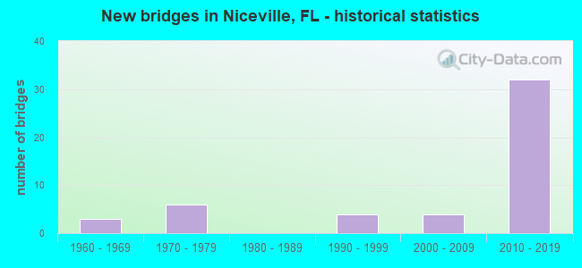
- New bridges - historical statistics
- 31960-1969
- 61970-1979
- 41990-1999
- 42000-2009
- 322010-2019


- Bridge Condition - Deck
- 8.3%Very good
- 72.2%Good
- 16.7%Satisfactory
- 2.8%Fair

- Bridge Condition - Superstructure
- 19.4%Very good
- 75.0%Good
- 2.8%Satisfactory
- 2.8%Fair

- Bridge Condition - Substructure
- 16.7%Very good
- 63.9%Good
- 13.9%Satisfactory
- 5.6%Fair

- Bridge Condition - Channel
- 6.7%Excellent
- 36.7%Very good
- 43.3%Good
- 10.0%Satisfactory
- 3.3%Fair

- Bridge Condition - Culverts
- 33.3%Good
- 33.3%Fair
- 33.3%Poor
Find on map >> Show street view
Structure Number: 570023, Location: 3.9Miles W of County Line (Lat: 30.505086, Lng: -86.440036), Route carried "on" structure: State highway 20, Year Built: 1972, Status: Open, Structure Length: 44.26m (145.21ft), Average Daily Traffic: 17,500 (year 2020), Truck Traffic: 6%, Average Future Daily Traffic: 30,362 (year 2042), Design Load: HS 20, Features Intersected: Rocky Bayou
Minimum Vertical Clearance: 30+ m (98+ ft), Kilometerpoint: 26.210, Lanes on structure: 2, Base Highway Network: Yes, Owner: State Highway Agency, Approaching Roadway Width: 7.9m (25.9ft), Material/Design: Prestressed concrete continuous, Design/Construction: Stringer/Multi-beam, Number Of Spans In Main Unit: 22, Length of Maximum Span: 20.1m (65.9ft), Curb-To-Curb Width: 13.2m (43.3ft), Out-to-Out Width: 14.1m (46.3ft)
Condition: Deck: Satisfactory, Superstructure: Good, Substructure: Satisfactory, Channel: Very good, Operating Rating: 70.8 metric tons, Method Used To Determine Operating Rating: Load Factor (LF), Inventory Rating: 41.7 metric tons, Method Used To Determine Inventory Rating: Load Factor (LF), Structural Evaluation: Equal to present minimum criteria, Deck Geometry: Superior to present desirable criteria, Waterway Adequacy: Equal to present desirable criteria, Approach Roadway Alignment: Equal to present desirable criteria, Designated Inspection Frequency: Every 24 months, Underwater Inspection Frequency: Every 24 months, Inspection Date: Febuary 2021, Underwater Inspection Date: Febuary 2021, Deck Structure Type: Concrete Cast-file-Place
Find on map >> Show street view
Structure Number: 570037, Location: 1.9 MI N of SR20 (Lat: 30.528139, Lng: -86.466944), Route carried "on" structure: State highway 285, Year Built: 1974, Status: Open, Structure Length: 0.76m (2.49ft), Average Daily Traffic: 7,900 (year 2020), Truck Traffic: 6%, Average Future Daily Traffic: 13,706 (year 2042), Design Load: HS 20, Features Intersected: Swift Creek
Minimum Vertical Clearance: 30+ m (98+ ft), Kilometerpoint: 3.103, Lanes on structure: 4, Owner: State Highway Agency, Approaching Roadway Width: 18.3m (60.0ft), Skew: 10 degrees, Material/Design: Concrete, Design/Construction: Culvert, Number Of Spans In Main Unit: 2, Length of Maximum Span: 3.7m (12.1ft)
Condition: Channel: Satisfactory, Culverts: Fair, Structural Evaluation: Somewhat better than minimum adequacy, Waterway Adequacy: Equal to present minimum criteria, Approach Roadway Alignment: Equal to present desirable criteria, Designated Inspection Frequency: Every 24 months, Underwater Inspection Frequency: Every 24 months, Inspection Date: July 2020, Underwater Inspection Date: July 2020
Find on map >> Show street view
Structure Number: 570063, Location: 0.2 Mi S of John Sims Pkw (Lat: 30.519806, Lng: -86.489250), Route carried "on" structure: Business City street , Year Built: 1962, Status: Open, Structure Length: 0.63m (2.07ft), Average Daily Traffic: 2,200 (year 2020), Truck Traffic: 6%, Average Future Daily Traffic: 3,817 (year 2042), Design Load: HS 20, Features Intersected: Unnamed Creek, Facility Carried by Structure: Bay Shore Drive
Minimum Vertical Clearance: 30+ m (98+ ft), Kilometerpoint: 0.320, Lanes on structure: 2, Owner: City or Municipal Highway Agency, Approaching Roadway Width: 6.7m (22.0ft), Material/Design: Concrete, Design/Construction: Culvert, Number Of Spans In Main Unit: 2, Length of Maximum Span: 3.2m (10.5ft), Curb or Sidewalk Widths: Left: 0.0m, Right: 1.8m (5.9ft)
Condition: Channel: Satisfactory, Culverts: Good, Operating Rating: 68.0 metric tons, Method Used To Determine Operating Rating: Load Factor (LF), Inventory Rating: 40.8 metric tons, Method Used To Determine Inventory Rating: Load Factor (LF), Structural Evaluation: Better than present minimum criteria, Waterway Adequacy: Better than present minimum criteria, Approach Roadway Alignment: Equal to present desirable criteria, Designated Inspection Frequency: Every 24 months, Inspection Date: April 2021
Find on map >> Show street view
Structure Number: 570076, Location: 0.5 Miles S. of SR85 (Lat: 30.554333, Lng: -86.532078), Route carried "on" structure: State highway 123, Year Built: 1975, Status: Open, Structure Length: 25.30m (83.01ft), Average Daily Traffic: 10,750 (year 2020), Truck Traffic: 6%, Average Future Daily Traffic: 18,651 (year 2042), Design Load: HS 20, Features Intersected: Turkey Creek
Minimum Vertical Clearance: 30+ m (98+ ft), Kilometerpoint: 6.688, Lanes on structure: 2, Base Highway Network: Yes, Owner: State Highway Agency, Approaching Roadway Width: 12.2m (40.0ft), Material/Design: Prestressed concrete, Design/Construction: Stringer/Multi-beam, Number Of Spans In Main Unit: 16, Length of Maximum Span: 15.8m (51.8ft), Curb-To-Curb Width: 13.4m (44.0ft), Out-to-Out Width: 14.3m (46.9ft)
Condition: Deck: Satisfactory, Superstructure: Good, Substructure: Good, Channel: Very good, Operating Rating: 78.0 metric tons, Method Used To Determine Operating Rating: Load Factor (LF), Inventory Rating: 47.2 metric tons, Method Used To Determine Inventory Rating: Load Factor (LF), Structural Evaluation: Better than present minimum criteria, Deck Geometry: Superior to present desirable criteria, Waterway Adequacy: Equal to present desirable criteria, Approach Roadway Alignment: Equal to present desirable criteria, Designated Inspection Frequency: Every 24 months, Inspection Date: July 2021, Deck Structure Type: Concrete Cast-file-Place
Find on map >> Show street view
Structure Number: 570077, Location: 3.4 Miles North of SR20 (Lat: 30.557833, Lng: -86.519636), Route carried "on" structure: State highway 85, Year Built: 1976, Status: Open, Structure Length: 3.54m (11.61ft), Average Daily Traffic: 8,066 (year 2020), Truck Traffic: 6%, Average Future Daily Traffic: 13,994 (year 2042), Design Load: HS 20, Features Intersected: Juniper Creek
Minimum Vertical Clearance: 30+ m (98+ ft), Kilometerpoint: 5.498, Lanes on structure: 2, Base Highway Network: Yes, Owner: State Highway Agency, Approaching Roadway Width: 8.8m (28.9ft), Material/Design: Prestressed concrete continuous, Design/Construction: Stringer/Multi-beam, Number Of Spans In Main Unit: 3, Length of Maximum Span: 11.8m (38.7ft), Curb-To-Curb Width: 12.0m (39.4ft), Out-to-Out Width: 13.2m (43.3ft)
Condition: Deck: Satisfactory, Superstructure: Good, Substructure: Satisfactory, Channel: Good, Operating Rating: 55.3 metric tons, Method Used To Determine Operating Rating: Load Factor (LF), Inventory Rating: 33.6 metric tons, Method Used To Determine Inventory Rating: Load Factor (LF), Structural Evaluation: Equal to present minimum criteria, Deck Geometry: Better than present minimum criteria, Waterway Adequacy: Equal to present desirable criteria, Approach Roadway Alignment: Equal to present desirable criteria, Designated Inspection Frequency: Every 24 months, Underwater Inspection Frequency: Every 24 months, Inspection Date: December 2020, Underwater Inspection Date: December 2020, Deck Structure Type: Concrete Cast-file-Place
Find on map >> Show street view
Structure Number: 570081, Location: 1.6MI East of SR285 (Lat: 30.513306, Lng: -86.454194), Route carried "on" structure: State highway 20, Year Built: 1974, Status: Open, Structure Length: 2.90m (9.51ft), Average Daily Traffic: 35,500 (year 2020), Truck Traffic: 6%, Average Future Daily Traffic: 61,592 (year 2042), Design Load: HS 20, Features Intersected: Swift Creek
Minimum Vertical Clearance: 30+ m (98+ ft), Kilometerpoint: 24.678, Lanes on structure: 4, Base Highway Network: Yes, Owner: State Highway Agency, Approaching Roadway Width: 19.5m (64.0ft), Skew: 23 degrees, Material/Design: Concrete continuous, Design/Construction: Slab, Number Of Spans In Main Unit: 3, Length of Maximum Span: 9.8m (32.2ft), Curb or Sidewalk Widths: Left: 1.5m (4.9ft), Right: 1.5m (4.9ft), Curb-To-Curb Width: 19.5m (64.0ft), Out-to-Out Width: 23.1m (75.8ft)
Condition: Deck: Fair, Superstructure: Fair, Substructure: Satisfactory, Channel: Good, Operating Rating: 51.9 metric tons, Method Used To Determine Operating Rating: Load Factor (LF), Inventory Rating: 31.3 metric tons, Method Used To Determine Inventory Rating: Load Factor (LF), Structural Evaluation: Somewhat better than minimum adequacy, Deck Geometry: Better than present minimum criteria, Waterway Adequacy: Better than present minimum criteria, Approach Roadway Alignment: Equal to present desirable criteria, Designated Inspection Frequency: Every 24 months, Inspection Date: November 2020, Deck Structure Type: Concrete Cast-file-Place
Find on map >> Show street view
Structure Number: 570086, Location: 3.4 Miles North of SR20 (Lat: 30.558078, Lng: -86.519514), Route carried "on" structure: State highway 85, Year Built: 1976, Status: Open, Structure Length: 3.54m (11.61ft), Average Daily Traffic: 8,066 (year 2020), Truck Traffic: 6%, Average Future Daily Traffic: 13,994 (year 2042), Design Load: HS 20, Features Intersected: Juniper Creek
Minimum Vertical Clearance: 30+ m (98+ ft), Kilometerpoint: 5.498, Lanes on structure: 2, Base Highway Network: Yes, Owner: State Highway Agency, Approaching Roadway Width: 8.8m (28.9ft), Material/Design: Prestressed concrete continuous, Design/Construction: Stringer/Multi-beam, Number Of Spans In Main Unit: 3, Length of Maximum Span: 11.8m (38.7ft), Curb-To-Curb Width: 12.0m (39.4ft), Out-to-Out Width: 13.2m (43.3ft)
Condition: Deck: Satisfactory, Superstructure: Good, Substructure: Satisfactory, Channel: Good, Operating Rating: 55.3 metric tons, Method Used To Determine Operating Rating: Load Factor (LF), Inventory Rating: 33.6 metric tons, Method Used To Determine Inventory Rating: Load Factor (LF), Structural Evaluation: Equal to present minimum criteria, Deck Geometry: Better than present minimum criteria, Waterway Adequacy: Equal to present desirable criteria, Approach Roadway Alignment: Equal to present desirable criteria, Designated Inspection Frequency: Every 24 months, Underwater Inspection Frequency: Every 24 months, Inspection Date: December 2020, Underwater Inspection Date: December 2020, Deck Structure Type: Concrete Cast-file-Place
Find on map >> Show street view
Structure Number: 570094, Location: 4.6mi. North of US98 (Lat: 30.455292, Lng: -86.415781), Route carried "on" structure: State highway 293, Year Built: 1993, Year Reconstructed: 2008, Status: Open, Structure Length: 0.95m (3.12ft), Average Daily Traffic: 12,000 (year 2012), Truck Traffic: 4%, Average Future Daily Traffic: 20,820 (year 2034), Design Load: HL 93, Features Intersected: Maxwell Gunter Road
Minimum Vertical Clearance: 4.94m (16.21ft), Kilometerpoint: 7.509, Lanes on structure: 2, Lanes under structure: 2, Toll: Toll bridge, Owner: Local Toll Authority, Maintenance Responsibility: State Highway Agency, Approaching Roadway Width: 12.2m (40.0ft), Material/Design: Prestressed concrete, Design/Construction: Slab, Number Of Spans In Main Unit: 1, Length of Maximum Span: 9.5m (31.2ft), Curb-To-Curb Width: 30.6m (100.4ft), Out-to-Out Width: 31.6m (103.7ft)
Condition: Deck: Good, Superstructure: Good, Substructure: Good, Operating Rating: 35.8 metric tons, Method Used To Determine Operating Rating: Load and Resistance Factor (LRFR), Inventory Rating: 27.3 metric tons, Method Used To Determine Inventory Rating: Load and Resistance Factor (LRFR), Structural Evaluation: Equal to present minimum criteria, Deck Geometry: Better than present minimum criteria, Underclear: High priority of corrective action, Approach Roadway Alignment: Equal to present desirable criteria, Designated Inspection Frequency: Every 24 months, Inspection Date: October 2020, Wearing Surface/Protective System: Wearing Surface: Bituminous
Find on map >> Show street view
Structure Number: 570097, Location: 3.9 Miles W. County Line (Lat: 30.505156, Lng: -86.439839), Route carried "on" structure: State highway 20, Year Built: 2001, Status: Open, Structure Length: 48.39m (158.76ft), Average Daily Traffic: 17,500 (year 2020), Truck Traffic: 6%, Average Future Daily Traffic: 30,362 (year 2042), Design Load: HS 20, Features Intersected: Rocky Bayou
Minimum Vertical Clearance: 30+ m (98+ ft), Kilometerpoint: 26.199, Lanes on structure: 2, Base Highway Network: Yes, Owner: State Highway Agency, Approaching Roadway Width: 7.3m (24.0ft), Skew: 2 degrees, Material/Design: Prestressed concrete continuous, Design/Construction: Stringer/Multi-beam, Number Of Spans In Main Unit: 25, Length of Maximum Span: 20.1m (65.9ft), Curb or Sidewalk Widths: Left: 1.5m (4.9ft), Right: 0.0m, Curb-To-Curb Width: 10.8m (35.4ft), Out-to-Out Width: 13.2m (43.3ft)
Condition: Deck: Satisfactory, Superstructure: Good, Substructure: Good, Channel: Very good, Operating Rating: 88.0 metric tons, Method Used To Determine Operating Rating: Load Factor (LF), Inventory Rating: 52.6 metric tons, Method Used To Determine Inventory Rating: Load Factor (LF), Structural Evaluation: Better than present minimum criteria, Deck Geometry: Somewhat better than minimum adequacy, Waterway Adequacy: Equal to present desirable criteria, Approach Roadway Alignment: Equal to present desirable criteria, Designated Inspection Frequency: Every 24 months, Underwater Inspection Frequency: Every 24 months, Inspection Date: Febuary 2021, Underwater Inspection Date: Febuary 2021, Deck Structure Type: Concrete Cast-file-Place
Find on map >> Show street view
Structure Number: 570125, Location: 1.1MI W OF SR285 (Lat: 30.523194, Lng: -86.499019), Route carried "on" structure: State highway 85, Year Built: 2001, Status: Open, Structure Length: 9.46m (31.04ft), Average Daily Traffic: 40,000 (year 2020), Truck Traffic: 6%, Average Future Daily Traffic: 69,400 (year 2042), Design Load: HS 20, Features Intersected: Boggy Bayou
Minimum Vertical Clearance: 30+ m (98+ ft), Kilometerpoint: 20.202, Lanes on structure: 6, Base Highway Network: Yes, Owner: State Highway Agency, Approaching Roadway Width: 13.1m (43.0ft), Skew: 20 degrees, Material/Design: Concrete continuous, Design/Construction: Slab, Number Of Spans In Main Unit: 12, Length of Maximum Span: 7.9m (25.9ft), Curb or Sidewalk Widths: Left: 1.5m (4.9ft), Right: 1.5m (4.9ft), Curb-To-Curb Width: 26.8m (87.9ft), Out-to-Out Width: 37.1m (121.7ft)
Condition: Deck: Satisfactory, Superstructure: Satisfactory, Substructure: Good, Channel: Good, Inventory Rating: 55.6 metric tons, Method Used To Determine Inventory Rating: Load Factor (LF), Structural Evaluation: Equal to present minimum criteria, Deck Geometry: Better than present minimum criteria, Waterway Adequacy: Equal to present desirable criteria, Approach Roadway Alignment: Equal to present desirable criteria, Designated Inspection Frequency: Every 24 months, Underwater Inspection Frequency: Every 24 months, Inspection Date: Febuary 2021, Underwater Inspection Date: Febuary 2021, Deck Structure Type: Concrete Cast-file-Place
Find on map >> Show street view
Structure Number: 570154, Location: SR293 over Lakeshore Dr. (Lat: 30.465444, Lng: -86.413111), Route carried "on" structure: State highway 293, Year Built: 2011, Status: Open, Structure Length: 2.90m (9.51ft), Average Daily Traffic: 17,000 (year 2010), Truck Traffic: 4%, Average Future Daily Traffic: 47,000 (year 2035), Design Load: HL 93, Features Intersected: Lakeshore Drive
Minimum Vertical Clearance: 30+ m (98+ ft), Kilometerpoint: 1.059, Lanes on structure: 4, Lanes under structure: 2, Base Highway Network: Yes, Owner: Local Toll Authority, Maintenance Responsibility: State Highway Agency, Approaching Roadway Width: 10.2m (33.5ft), Skew: 22 degrees, Material/Design: Prestressed concrete, Design/Construction: Stringer/Multi-beam, Number Of Spans In Main Unit: 1, Length of Maximum Span: 29.0m (95.1ft), Curb-To-Curb Width: 26.2m (86.0ft), Out-to-Out Width: 27.2m (89.2ft)
Condition: Deck: Good, Superstructure: Very good, Substructure: Good, Operating Rating: 41.2 metric tons, Method Used To Determine Operating Rating: Load and Resistance Factor (LRFR), Inventory Rating: 36.9 metric tons, Method Used To Determine Inventory Rating: Load and Resistance Factor (LRFR), Structural Evaluation: Better than present minimum criteria, Deck Geometry: Superior to present desirable criteria, Underclear: Superior to present desirable criteria, Approach Roadway Alignment: Equal to present desirable criteria, Designated Inspection Frequency: Every 24 months, Inspection Date: April 2021, Deck Structure Type: Concrete Cast-file-Place
Find on map >> Show street view
Structure Number: 570155, Location: 1.4 MI N of Mid-Bay Toll (Lat: 30.472819, Lng: -86.402311), Route carried "on" structure: State highway 293, Year Built: 2011, Status: Open, Structure Length: 7.47m (24.51ft), Average Daily Traffic: 17,000 (year 2012), Truck Traffic: 4%, Average Future Daily Traffic: 47,000 (year 2034), Design Load: HS 20, Features Intersected: SR20
Minimum Vertical Clearance: 30.45m (99.90ft), Kilometerpoint: 2.406, Lanes on structure: 2, Lanes under structure: 6, Base Highway Network: Yes, Toll: On toll road, Owner: Local Toll Authority, Maintenance Responsibility: State Highway Agency, Approaching Roadway Width: 10.4m (34.1ft), Material/Design: Steel, Design/Construction: Stringer/Multi-beam, Number Of Spans In Main Unit: 1, Length of Maximum Span: 74.7m (245.1ft), Curb-To-Curb Width: 12.2m (40.0ft), Out-to-Out Width: 13.1m (43.0ft)
Condition: Deck: Good, Superstructure: Very good, Substructure: Good, Operating Rating: 43.7 metric tons, Method Used To Determine Operating Rating: Load and Resistance Factor (LRFR), Inventory Rating: 33.7 metric tons, Method Used To Determine Inventory Rating: Load and Resistance Factor (LRFR), Structural Evaluation: Better than present minimum criteria, Deck Geometry: Better than present minimum criteria, Underclear: Equal to present minimum criteria, Approach Roadway Alignment: Equal to present desirable criteria, Designated Inspection Frequency: Every 24 months, Inspection Date: August 2021, Deck Structure Type: Concrete Cast-file-Place
Find on map >> Show street view
Structure Number: 570156, Location: 1.4 Mi N of Mid-Bay Toll (Lat: 30.472672, Lng: -86.402117), Route carried "on" structure: State highway 293, Year Built: 2011, Status: Open, Structure Length: 7.47m (24.51ft), Average Daily Traffic: 17,000 (year 2012), Truck Traffic: 4%, Average Future Daily Traffic: 47,000 (year 2034), Design Load: HL 93, Features Intersected: SR20
Minimum Vertical Clearance: 30.45m (99.90ft), Kilometerpoint: 2.406, Lanes on structure: 2, Lanes under structure: 6, Base Highway Network: Yes, Toll: On toll road, Owner: Local Toll Authority, Maintenance Responsibility: State Highway Agency, Approaching Roadway Width: 10.4m (34.1ft), Material/Design: Steel, Design/Construction: Stringer/Multi-beam, Number Of Spans In Main Unit: 1, Length of Maximum Span: 74.7m (245.1ft), Curb-To-Curb Width: 12.2m (40.0ft), Out-to-Out Width: 13.1m (43.0ft)
Condition: Deck: Good, Superstructure: Very good, Substructure: Good, Operating Rating: 43.7 metric tons, Method Used To Determine Operating Rating: Load and Resistance Factor (LRFR), Inventory Rating: 33.7 metric tons, Method Used To Determine Inventory Rating: Load and Resistance Factor (LRFR), Structural Evaluation: Better than present minimum criteria, Deck Geometry: Better than present minimum criteria, Underclear: Equal to present minimum criteria, Approach Roadway Alignment: Equal to present desirable criteria, Designated Inspection Frequency: Every 24 months, Inspection Date: August 2021, Deck Structure Type: Concrete Cast-file-Place
Find on map >> Show street view
Structure Number: 57016, Location: 1.0 Mi N of SR20 (Lat: 30.489333, Lng: -86.404750), Route carried "on" structure: State highway 293, Year Built: 2013, Status: Open, Structure Length: 2.36m (7.74ft), Average Daily Traffic: 12,000 (year 2013), Truck Traffic: 4%, Average Future Daily Traffic: 24,000 (year 2033), Design Load: HL 93, Features Intersected: Range Road
Minimum Vertical Clearance: 5.55m (18.21ft), Kilometerpoint: 4.437, Lanes on structure: 2, Lanes under structure: 2, Base Highway Network: Yes, Toll: On toll road, Owner: Local Toll Authority, Maintenance Responsibility: State Highway Agency, Approaching Roadway Width: 10.4m (34.1ft), Skew: 1 degrees, Material/Design: Prestressed concrete, Design/Construction: Stringer/Multi-beam, Number Of Spans In Main Unit: 1, Length of Maximum Span: 23.6m (77.4ft), Curb-To-Curb Width: 13.4m (44.0ft), Out-to-Out Width: 14.4m (47.2ft)
Condition: Deck: Good, Superstructure: Good, Substructure: Good, Operating Rating: 47.0 metric tons, Method Used To Determine Operating Rating: Load and Resistance Factor (LRFR), Inventory Rating: 36.3 metric tons, Method Used To Determine Inventory Rating: Load and Resistance Factor (LRFR), Structural Evaluation: Better than present minimum criteria, Deck Geometry: Equal to present minimum criteria, Underclear: Superior to present desirable criteria, Approach Roadway Alignment: Equal to present desirable criteria, Designated Inspection Frequency: Every 24 months, Inspection Date: October 2021, Deck Structure Type: Concrete Cast-file-Place
Find on map >> Show street view
Structure Number: 570163, Location: 2.5 Miles N of SR20 (Lat: 30.505861, Lng: -86.413222), Route carried "on" structure: State highway 293, Year Built: 2013, Status: Open, Structure Length: 52.67m (172.80ft), Average Daily Traffic: 12,000 (year 2013), Truck Traffic: 4%, Average Future Daily Traffic: 24,000 (year 2033), Design Load: HL 93, Features Intersected: Rocky Creek
Minimum Vertical Clearance: 30+ m (98+ ft), Kilometerpoint: 6.445, Lanes on structure: 2, Base Highway Network: Yes, Toll: On toll road, Owner: Local Toll Authority, Maintenance Responsibility: State Highway Agency, Approaching Roadway Width: 10.4m (34.1ft), Skew: 10 degrees, Material/Design: Prestressed concrete, Design/Construction: Stringer/Multi-beam, Number Of Spans In Main Unit: 21, Length of Maximum Span: 36.0m (118.1ft), Curb-To-Curb Width: 13.4m (44.0ft), Out-to-Out Width: 14.4m (47.2ft)
Condition: Deck: Good, Superstructure: Good, Substructure: Good, Channel: Very good, Operating Rating: 45.7 metric tons, Method Used To Determine Operating Rating: Load and Resistance Factor (LRFR), Inventory Rating: 35.3 metric tons, Method Used To Determine Inventory Rating: Load and Resistance Factor (LRFR), Structural Evaluation: Better than present minimum criteria, Deck Geometry: Equal to present minimum criteria, Waterway Adequacy: Superior to present desirable criteria, Approach Roadway Alignment: Equal to present desirable criteria, Designated Inspection Frequency: Every 24 months, Underwater Inspection Frequency: Every 24 months, Inspection Date: October 2021, Underwater Inspection Date: October 2021, Deck Structure Type: Concrete Cast-file-Place
Find on map >> Show street view
Structure Number: 570164, Location: 1.25MI E of SR285 (Lat: 30.536000, Lng: -86.433139), Route carried "on" structure: State highway 293, Year Built: 2013, Status: Open, Structure Length: 7.47m (24.51ft), Average Daily Traffic: 12,000 (year 2013), Truck Traffic: 4%, Average Future Daily Traffic: 24,000 (year 2033), Design Load: HL 93, Features Intersected: Deer Moss Creek
Minimum Vertical Clearance: 30+ m (98+ ft), Kilometerpoint: 10.897, Lanes on structure: 2, Base Highway Network: Yes, Toll: On toll road, Owner: Local Toll Authority, Maintenance Responsibility: State Highway Agency, Approaching Roadway Width: 10.4m (34.1ft), Material/Design: Prestressed concrete, Design/Construction: Stringer/Multi-beam, Number Of Spans In Main Unit: 3, Length of Maximum Span: 30.5m (100.1ft), Curb-To-Curb Width: 13.4m (44.0ft), Out-to-Out Width: 14.4m (47.2ft)
Condition: Deck: Good, Superstructure: Good, Substructure: Good, Channel: Very good, Operating Rating: 43.7 metric tons, Method Used To Determine Operating Rating: Load and Resistance Factor (LRFR), Inventory Rating: 33.0 metric tons, Method Used To Determine Inventory Rating: Load and Resistance Factor (LRFR), Structural Evaluation: Better than present minimum criteria, Deck Geometry: Equal to present minimum criteria, Waterway Adequacy: Equal to present desirable criteria, Approach Roadway Alignment: Equal to present desirable criteria, Designated Inspection Frequency: Every 24 months, Inspection Date: October 2021, Deck Structure Type: Concrete Cast-file-Place
Find on map >> Show street view
Structure Number: 570165, Location: 3.0 Miles S of SR85 (Lat: 30.541214, Lng: -86.454328), Route carried "on" structure: State highway 293, Year Built: 2013, Status: Open, Structure Length: 5.67m (18.60ft), Average Daily Traffic: 12,000 (year 2015), Truck Traffic: 4%, Average Future Daily Traffic: 24,000 (year 2035), Design Load: HL 93, Features Intersected: SR285
Minimum Vertical Clearance: 30+ m (98+ ft), Kilometerpoint: 13.053, Lanes on structure: 2, Lanes under structure: 4, Base Highway Network: Yes, Toll: On toll road, Owner: Local Toll Authority, Maintenance Responsibility: State Highway Agency, Approaching Roadway Width: 10.4m (34.1ft), Skew: 10 degrees, Material/Design: Steel, Design/Construction: Stringer/Multi-beam, Number Of Spans In Main Unit: 1, Length of Maximum Span: 56.7m (186.0ft), Curb-To-Curb Width: 13.4m (44.0ft), Out-to-Out Width: 14.4m (47.2ft)
Condition: Deck: Very good, Superstructure: Good, Substructure: Very good, Operating Rating: 48.4 metric tons, Method Used To Determine Operating Rating: Load and Resistance Factor (LRFR), Inventory Rating: 37.2 metric tons, Method Used To Determine Inventory Rating: Load and Resistance Factor (LRFR), Structural Evaluation: Better than present minimum criteria, Deck Geometry: Equal to present minimum criteria, Underclear: Superior to present desirable criteria, Approach Roadway Alignment: Equal to present desirable criteria, Designated Inspection Frequency: Every 24 months, Inspection Date: November 2021, Deck Structure Type: Concrete Cast-file-Place
Find on map >> Show street view
Structure Number: 570166, Location: 0.75 Mi North of SR285 (Lat: 30.545333, Lng: -86.464944), Route carried "on" structure: State highway 293, Year Built: 2013, Status: Open, Structure Length: 10.36m (33.99ft), Average Daily Traffic: 12,000 (year 2014), Truck Traffic: 4%, Average Future Daily Traffic: 24,000 (year 2036), Design Load: HL 93, Features Intersected: Swift Creek
Minimum Vertical Clearance: 30+ m (98+ ft), Kilometerpoint: 14.178, Lanes on structure: 2, Base Highway Network: Yes, Toll: On toll road, Owner: Local Toll Authority, Maintenance Responsibility: State Highway Agency, Approaching Roadway Width: 10.4m (34.1ft), Material/Design: Steel continuous, Design/Construction: Stringer/Multi-beam, Number Of Spans In Main Unit: 3, Length of Maximum Span: 44.2m (145.0ft), Curb-To-Curb Width: 13.4m (44.0ft), Out-to-Out Width: 14.4m (47.2ft)
Condition: Deck: Good, Superstructure: Good, Substructure: Good, Channel: Very good, Operating Rating: 45.7 metric tons, Method Used To Determine Operating Rating: Load and Resistance Factor (LRFR), Inventory Rating: 35.3 metric tons, Method Used To Determine Inventory Rating: Load and Resistance Factor (LRFR), Structural Evaluation: Better than present minimum criteria, Deck Geometry: Equal to present minimum criteria, Waterway Adequacy: Equal to present desirable criteria, Approach Roadway Alignment: Equal to present desirable criteria, Designated Inspection Frequency: Every 24 months, Inspection Date: November 2021, Deck Structure Type: Concrete Cast-file-Place
Find on map >> Show street view
Structure Number: 570167, Location: 1.6 Miles South of SR85 (Lat: 30.546917, Lng: -86.470167), Route carried "on" structure: State highway 293, Year Built: 2013, Status: Open, Structure Length: 9.14m (29.99ft), Average Daily Traffic: 17,000 (year 2013), Truck Traffic: 4%, Average Future Daily Traffic: 22,000 (year 2033), Design Load: HL 93, Features Intersected: Foxhead Branch
Minimum Vertical Clearance: 30+ m (98+ ft), Kilometerpoint: 14.711, Lanes on structure: 2, Base Highway Network: Yes, Toll: On toll road, Owner: Local Toll Authority, Maintenance Responsibility: State Highway Agency, Approaching Roadway Width: 10.4m (34.1ft), Material/Design: Prestressed concrete, Design/Construction: Stringer/Multi-beam, Number Of Spans In Main Unit: 3, Length of Maximum Span: 33.5m (109.9ft), Curb-To-Curb Width: 13.2m (43.3ft), Out-to-Out Width: 14.4m (47.2ft)
Condition: Deck: Good, Superstructure: Good, Substructure: Good, Channel: Very good, Operating Rating: 41.2 metric tons, Method Used To Determine Operating Rating: Load and Resistance Factor (LRFR), Inventory Rating: 37.2 metric tons, Method Used To Determine Inventory Rating: Load and Resistance Factor (LRFR), Structural Evaluation: Better than present minimum criteria, Deck Geometry: Somewhat better than minimum adequacy, Waterway Adequacy: Equal to present desirable criteria, Approach Roadway Alignment: Equal to present desirable criteria, Designated Inspection Frequency: Every 24 months, Inspection Date: October 2021, Deck Structure Type: Concrete Cast-file-Place
Find on map >> Show street view
Structure Number: 570168, Location: 0.5 mi. South of SR85 (Lat: 30.547528, Lng: -86.485750), Route carried "on" structure: State highway 293, Year Built: 2013, Status: Open, Structure Length: 7.32m (24.02ft), Average Daily Traffic: 12,000 (year 2014), Truck Traffic: 4%, Average Future Daily Traffic: 24,000 (year 2036), Design Load: HL 93, Features Intersected: Mill Creek
Minimum Vertical Clearance: 30+ m (98+ ft), Kilometerpoint: 16.216, Lanes on structure: 2, Base Highway Network: Yes, Toll: On toll road, Owner: Local Toll Authority, Maintenance Responsibility: State Highway Agency, Approaching Roadway Width: 10.4m (34.1ft), Skew: 12 degrees, Material/Design: Prestressed concrete, Design/Construction: Stringer/Multi-beam, Number Of Spans In Main Unit: 3, Length of Maximum Span: 27.4m (89.9ft), Curb-To-Curb Width: 13.4m (44.0ft), Out-to-Out Width: 14.4m (47.2ft)
Condition: Deck: Good, Superstructure: Good, Substructure: Good, Channel: Very good, Operating Rating: 40.8 metric tons, Method Used To Determine Operating Rating: Load and Resistance Factor (LRFR), Inventory Rating: 35.3 metric tons, Method Used To Determine Inventory Rating: Load and Resistance Factor (LRFR), Structural Evaluation: Better than present minimum criteria, Deck Geometry: Equal to present minimum criteria, Waterway Adequacy: Equal to present desirable criteria, Approach Roadway Alignment: Equal to present desirable criteria, Designated Inspection Frequency: Every 24 months, Inspection Date: November 2021, Deck Structure Type: Concrete Cast-file-Place
Find on map >> Show street view
Structure Number: 570169, Location: SR293 at SR85 (Lat: 30.544514, Lng: -86.494792), Route carried "on" structure: State highway 293, Year Built: 2013, Status: Open, Structure Length: 6.40m (21.00ft), Average Daily Traffic: 17,000 (year 2015), Truck Traffic: 4%, Average Future Daily Traffic: 22,000 (year 2035), Design Load: HL 93, Features Intersected: SR85
Minimum Vertical Clearance: 30+ m (98+ ft), Kilometerpoint: 17.154, Lanes on structure: 2, Lanes under structure: 5, Base Highway Network: Yes, Toll: On toll road, Owner: Local Toll Authority, Maintenance Responsibility: State Highway Agency, Approaching Roadway Width: 4.9m (16.1ft), Material/Design: Prestressed concrete, Design/Construction: Stringer/Multi-beam, Number Of Spans In Main Unit: 2, Length of Maximum Span: 33.5m (109.9ft), Curb-To-Curb Width: 17.1m (56.1ft), Out-to-Out Width: 18.0m (59.1ft)
Condition: Deck: Good, Superstructure: Good, Substructure: Good, Operating Rating: 43.5 metric tons, Method Used To Determine Operating Rating: Load and Resistance Factor (LRFR), Inventory Rating: 39.6 metric tons, Method Used To Determine Inventory Rating: Load and Resistance Factor (LRFR), Structural Evaluation: Better than present minimum criteria, Deck Geometry: Superior to present desirable criteria, Underclear: Superior to present desirable criteria, Approach Roadway Alignment: Equal to present desirable criteria, Designated Inspection Frequency: Every 24 months, Inspection Date: December 2021, Deck Structure Type: Concrete Cast-file-Place
Find on map >> Show street view
Structure Number: 570176, Location: 1.3 Miles South of SR85 (Lat: 30.546278, Lng: -86.536472), Route carried "on" structure: State highway 123, Year Built: 2017, Status: Open, Structure Length: 5.06m (16.60ft), Average Daily Traffic: 10,750 (year 2020), Truck Traffic: 6%, Average Future Daily Traffic: 18,651 (year 2042), Design Load: HL 93, Features Intersected: Unnamed Tributary
Minimum Vertical Clearance: 30+ m (98+ ft), Kilometerpoint: 5.821, Lanes on structure: 2, Base Highway Network: Yes, Owner: State Highway Agency, Approaching Roadway Width: 10.4m (34.1ft), Material/Design: Prestressed concrete, Design/Construction: Stringer/Multi-beam, Number Of Spans In Main Unit: 3, Length of Maximum Span: 18.2m (59.7ft), Curb-To-Curb Width: 12.2m (40.0ft), Out-to-Out Width: 13.1m (43.0ft)
Condition: Deck: Very good, Superstructure: Good, Substructure: Good, Operating Rating: 43.5 metric tons, Method Used To Determine Operating Rating: Load and Resistance Factor (LRFR), Inventory Rating: 33.9 metric tons, Method Used To Determine Inventory Rating: Load and Resistance Factor (LRFR), Structural Evaluation: Better than present minimum criteria, Deck Geometry: Better than present minimum criteria, Waterway Adequacy: Equal to present desirable criteria, Approach Roadway Alignment: Equal to present desirable criteria, Designated Inspection Frequency: Every 24 months, Inspection Date: Febuary 2021, Deck Structure Type: Concrete Cast-file-Place
Find on map >> Show street view
Structure Number: 570177, Location: 4.0MI North of SR85 (Lat: 30.553353, Lng: -86.532833), Route carried "on" structure: State highway 123, Year Built: 2015, Status: Open, Structure Length: 25.30m (83.01ft), Average Daily Traffic: 10,750 (year 2020), Truck Traffic: 6%, Average Future Daily Traffic: 18,651 (year 2042), Design Load: HL 93, Features Intersected: Turkey Creek
Minimum Vertical Clearance: 30+ m (98+ ft), Kilometerpoint: 6.688, Lanes on structure: 2, Base Highway Network: Yes, Owner: State Highway Agency, Approaching Roadway Width: 10.4m (34.1ft), Material/Design: Prestressed concrete, Design/Construction: Stringer/Multi-beam, Number Of Spans In Main Unit: 9, Length of Maximum Span: 31.7m (104.0ft), Curb-To-Curb Width: 12.2m (40.0ft), Out-to-Out Width: 13.1m (43.0ft)
Condition: Deck: Good, Superstructure: Good, Substructure: Very good, Channel: Very good, Operating Rating: 47.4 metric tons, Method Used To Determine Operating Rating: Load and Resistance Factor (LRFR), Inventory Rating: 43.7 metric tons, Method Used To Determine Inventory Rating: Load and Resistance Factor (LRFR), Structural Evaluation: Better than present minimum criteria, Deck Geometry: Better than present minimum criteria, Waterway Adequacy: Equal to present desirable criteria, Approach Roadway Alignment: Equal to present desirable criteria, Designated Inspection Frequency: Every 24 months, Inspection Date: May 2020, Deck Structure Type: Concrete Cast-file-Place
Find on map >> Show street view
Structure Number: 570178, Location: 1.3 miles South of SR85 (Lat: 30.546333, Lng: -86.536750), Route carried "on" structure: State highway 123, Year Built: 2016, Status: Open, Structure Length: 5.06m (16.60ft), Average Daily Traffic: 10,750 (year 2020), Truck Traffic: 6%, Average Future Daily Traffic: 18,651 (year 2042), Design Load: HL 93, Features Intersected: Unnamed Tributary
Minimum Vertical Clearance: 30+ m (98+ ft), Kilometerpoint: 5.821, Lanes on structure: 2, Base Highway Network: Yes, Owner: State Highway Agency, Approaching Roadway Width: 10.4m (34.1ft), Material/Design: Prestressed concrete, Design/Construction: Stringer/Multi-beam, Number Of Spans In Main Unit: 3, Length of Maximum Span: 18.1m (59.4ft), Curb-To-Curb Width: 12.2m (40.0ft), Out-to-Out Width: 13.1m (43.0ft)
Condition: Deck: Good, Superstructure: Very good, Substructure: Good, Channel: Very good, Operating Rating: 43.5 metric tons, Method Used To Determine Operating Rating: Load and Resistance Factor (LRFR), Inventory Rating: 33.9 metric tons, Method Used To Determine Inventory Rating: Load and Resistance Factor (LRFR), Structural Evaluation: Better than present minimum criteria, Deck Geometry: Better than present minimum criteria, Waterway Adequacy: Equal to present desirable criteria, Approach Roadway Alignment: Equal to present desirable criteria, Designated Inspection Frequency: Every 24 months, Inspection Date: Febuary 2021, Deck Structure Type: Concrete Cast-file-Place
Find on map >> Show street view
Structure Number: 570179, Location: SR123 over SR85 (Lat: 30.562947, Lng: -86.527911), Route carried "on" structure: Ramp State highway 123, Year Built: 2016, Status: Open, Structure Length: 11.71m (38.42ft), Average Daily Traffic: 10,500 (year 2020), Truck Traffic: 6%, Average Future Daily Traffic: 18,218 (year 2042), Design Load: HL 93, Features Intersected: SR85
Minimum Vertical Clearance: 30.45m (99.90ft), Kilometerpoint: 0.863, Lanes on structure: 2, Lanes under structure: 7, Base Highway Network: Yes, Owner: State Highway Agency, Approaching Roadway Width: 12.2m (40.0ft), Material/Design: Steel continuous, Design/Construction: Stringer/Multi-beam, Number Of Spans In Main Unit: 2, Length of Maximum Span: 58.6m (192.3ft), Curb-To-Curb Width: 13.4m (44.0ft), Out-to-Out Width: 14.4m (47.2ft)
Condition: Deck: Good, Superstructure: Very good, Substructure: Very good, Operating Rating: 45.1 metric tons, Method Used To Determine Operating Rating: Load and Resistance Factor (LRFR), Inventory Rating: 34.7 metric tons, Method Used To Determine Inventory Rating: Load and Resistance Factor (LRFR), Structural Evaluation: Equal to present desirable criteria, Deck Geometry: Superior to present desirable criteria, Underclear: Better than present minimum criteria, Approach Roadway Alignment: Equal to present desirable criteria, Designated Inspection Frequency: Every 24 months, Inspection Date: April 2020, Deck Structure Type: Concrete Cast-file-Place
Find on map >> Show street view
Structure Number: 574131, Location: 0.5 Mi West of Hwy 285 (Lat: 30.534625, Lng: -86.467703), Route carried "on" structure: County highway , Year Built: 1997, Status: Open, Structure Length: 0.63m (2.07ft), Average Daily Traffic: 5,900 (year 2020), Truck Traffic: 5%, Average Future Daily Traffic: 10,237 (year 2042), Design Load: H 15, Features Intersected: Roberts Lake Dam, Facility Carried by Structure: College Blvd
Minimum Vertical Clearance: 30+ m (98+ ft), Kilometerpoint: 2.391, Lanes on structure: 2, Owner: County Highway Agency, Approaching Roadway Width: 10.1m (33.1ft), Material/Design: Concrete, Design/Construction: Culvert, Number Of Spans In Main Unit: 2, Length of Maximum Span: 3.1m (10.2ft)
Condition: Channel: Excellent, Culverts: Poor, Inventory Rating: 67.5 metric tons, Method Used To Determine Inventory Rating: Load Factor (LF), Structural Evaluation: Meets minimum limits, Waterway Adequacy: Equal to present desirable criteria, Approach Roadway Alignment: Equal to present desirable criteria, Designated Inspection Frequency: Every 24 months, Other Special Inspection Frequency: Every 12 months, Inspection Date: December 2020, Other Special Inspection Date: December 2021
Find on map >> Show street view
Structure Number: 574181, Location: 1.5 Mi East of SR 20 (Lat: 30.512392, Lng: -86.425219), Route carried "on" structure: County highway , Year Built: 2014, Status: Open, Structure Length: 1.22m (4.00ft), Average Daily Traffic: 7,400 (year 2019), Truck Traffic: 4%, Average Future Daily Traffic: 12,839 (year 2041), Design Load: HL 93, Features Intersected: Deer Moss Creek, Facility Carried by Structure: Rocky Bayou Dr
Minimum Vertical Clearance: 30+ m (98+ ft), Kilometerpoint: 2.462, Lanes on structure: 2, Owner: County Highway Agency, Approaching Roadway Width: 6.7m (22.0ft), Material/Design: Concrete, Design/Construction: Channel Beam, Number Of Spans In Main Unit: 1, Length of Maximum Span: 12.2m (40.0ft), Curb or Sidewalk Widths: Left: 0.0m, Right: 1.8m (5.9ft), Curb-To-Curb Width: 8.9m (29.2ft), Out-to-Out Width: 10.7m (35.1ft)
Condition: Deck: Good, Superstructure: Very good, Substructure: Very good, Channel: Good, Operating Rating: 32.7 metric tons, Method Used To Determine Operating Rating: Load and Resistance Factor (LRFR), Inventory Rating: 25.1 metric tons, Method Used To Determine Inventory Rating: Load and Resistance Factor (LRFR), Structural Evaluation: Equal to present minimum criteria, Deck Geometry: High priority of replacement, Waterway Adequacy: Equal to present desirable criteria, Approach Roadway Alignment: Equal to present desirable criteria, Designated Inspection Frequency: Every 24 months, Inspection Date: July 2020, Deck Structure Type: Concrete Precast Panels
Find on map >> Show street view
Structure Number: 575187, Location: 1.7 Mi E of Hwy 285 (Lat: 30.513611, Lng: -86.454167), Route carried "on" structure: City street , Year Built: 2014, Status: Open, Structure Length: 2.44m (8.01ft), Average Daily Traffic: 1,000 (year 2020), Truck Traffic: 5%, Average Future Daily Traffic: 1,735 (year 2042), Design Load: HL 93, Features Intersected: Swift Creek, Facility Carried by Structure: Access Rd
Minimum Vertical Clearance: 30+ m (98+ ft), Kilometerpoint: 0.435, Lanes on structure: 2, Owner: City or Municipal Highway Agency, Approaching Roadway Width: 7.1m (23.3ft), Material/Design: Concrete, Design/Construction: Channel Beam, Number Of Spans In Main Unit: 2, Length of Maximum Span: 12.2m (40.0ft), Curb-To-Curb Width: 8.5m (27.9ft), Out-to-Out Width: 9.6m (31.5ft)
Condition: Deck: Very good, Superstructure: Very good, Substructure: Very good, Channel: Excellent, Operating Rating: 32.8 metric tons, Method Used To Determine Operating Rating: Load and Resistance Factor (LRFR), Inventory Rating: 25.3 metric tons, Method Used To Determine Inventory Rating: Load and Resistance Factor (LRFR), Structural Evaluation: Equal to present minimum criteria, Deck Geometry: Somewhat better than minimum adequacy, Waterway Adequacy: Better than present minimum criteria, Approach Roadway Alignment: Equal to present minimum criteria, Designated Inspection Frequency: Every 24 months, Inspection Date: October 2020, Deck Structure Type: Concrete Cast-file-Place
Find on map >> Show street view
Structure Number: 575188, Location: Just West of Revell Drive (Lat: 30.515978, Lng: -86.458864), Route carried "on" structure: City street , Year Built: 2014, Status: Open, Structure Length: 4.88m (16.01ft), Average Daily Traffic: 2,000 (year 2020), Truck Traffic: 50%, Average Future Daily Traffic: 3,470 (year 2042), Design Load: HL 93, Features Intersected: Unnamed Canal, Facility Carried by Structure: Access Rd
Minimum Vertical Clearance: 30+ m (98+ ft), Kilometerpoint: 0.000, Lanes on structure: 2, Owner: City or Municipal Highway Agency, Approaching Roadway Width: 10.0m (32.8ft), Material/Design: Concrete, Design/Construction: Channel Beam, Number Of Spans In Main Unit: 4, Length of Maximum Span: 12.2m (40.0ft), Curb or Sidewalk Widths: Left: 2.0m (6.6ft), Right: 0.0m, Curb-To-Curb Width: 8.7m (28.5ft), Out-to-Out Width: 11.5m (37.7ft)
Condition: Deck: Good, Superstructure: Good, Substructure: Very good, Channel: Very good, Operating Rating: 32.8 metric tons, Method Used To Determine Operating Rating: Load and Resistance Factor (LRFR), Inventory Rating: 25.3 metric tons, Method Used To Determine Inventory Rating: Load and Resistance Factor (LRFR), Structural Evaluation: Equal to present minimum criteria, Deck Geometry: Somewhat better than minimum adequacy, Waterway Adequacy: Better than present minimum criteria, Approach Roadway Alignment: Better than present minimum criteria, Designated Inspection Frequency: Every 24 months, Inspection Date: October 2020, Deck Structure Type: Concrete Cast-file-Place
Find on map >> Show street view
Structure Number: AFFLFTFA12209, Location: 1.5 MILES EAST OF S.R. 85 (Lat: 30.569917, Lng: -86.515639), Route carried "on" structure: Federal lands road 231, Year Built: 1965, Status: Open, Structure Length: 1.89m (6.20ft), Average Daily Traffic: 50 (year 2021), Average Future Daily Traffic: 55 (year 2041), Features Intersected: TEN MILE CREEK
Minimum Vertical Clearance: 30+ m (98+ ft), Kilometerpoint: 0.000, Lanes on structure: 2, Owner: Air Force, Approaching Roadway Width: 7.7m (25.3ft), Material/Design: Concrete, Design/Construction: Slab, Number Of Spans In Main Unit: 2, Length of Maximum Span: 9.1m (29.9ft), Curb-To-Curb Width: 7.4m (24.3ft), Out-to-Out Width: 7.7m (25.3ft)
Condition: Deck: Good, Superstructure: Good, Substructure: Fair, Channel: Good, Operating Rating: 57.1 metric tons, Method Used To Determine Operating Rating: Load Factor (LF), Inventory Rating: 34.5 metric tons, Method Used To Determine Inventory Rating: Load Factor (LF), Structural Evaluation: Somewhat better than minimum adequacy, Deck Geometry: Equal to present minimum criteria, Waterway Adequacy: Equal to present minimum criteria, Approach Roadway Alignment: Equal to present desirable criteria, Designated Inspection Frequency: Every 24 months, Inspection Date: October 2021, Bridge Improvement Cost: $60,000, Roadway Improvement Cost: $60,000, Total Project Cost: $90,000, Deck Structure Type: Concrete Precast Panels
Find on map >> Show street view
Structure Number: AFFLFTFA1221, Location: 0.75 MILES WEST OF S.R. 8 (Lat: 30.561556, Lng: -86.536694), Route carried "on" structure: Federal lands road 232, Year Built: 1965, Status: Open, Structure Length: 1.89m (6.20ft), Average Daily Traffic: 50 (year 2021), Average Future Daily Traffic: 55 (year 2041), Features Intersected: TURKEY CREEK
Minimum Vertical Clearance: 30+ m (98+ ft), Kilometerpoint: 0.000, Lanes on structure: 2, Owner: Air Force, Approaching Roadway Width: 7.6m (24.9ft), Material/Design: Concrete, Design/Construction: Slab, Number Of Spans In Main Unit: 2, Length of Maximum Span: 9.4m (30.8ft), Curb-To-Curb Width: 7.4m (24.3ft), Out-to-Out Width: 7.6m (24.9ft)
Condition: Deck: Good, Superstructure: Good, Substructure: Fair, Channel: Good, Operating Rating: 49.0 metric tons, Method Used To Determine Operating Rating: Load Factor (LF), Inventory Rating: 29.0 metric tons, Method Used To Determine Inventory Rating: Load Factor (LF), Structural Evaluation: Somewhat better than minimum adequacy, Deck Geometry: Equal to present minimum criteria, Waterway Adequacy: Equal to present minimum criteria, Approach Roadway Alignment: Equal to present desirable criteria, Designated Inspection Frequency: Every 24 months, Inspection Date: October 2021, Bridge Improvement Cost: $90,000, Roadway Improvement Cost: $9,000, Total Project Cost: $135,000, Deck Structure Type: Concrete Precast Panels, Wearing Surface/Protective System: Wearing Surface: Bituminous
Find on map >> Show street view
Structure Number: AFFLFTFA12256, Location: 0.3 MILES NORTH OF S.R.85 (Lat: 30.559722, Lng: -86.510444), Route carried "on" structure: Federal lands road 231, Year Built: 2014, Status: Open, Structure Length: 1.22m (4.00ft), Average Daily Traffic: 20 (year 2021), Average Future Daily Traffic: 24 (year 2041), Design Load: HS 20, Features Intersected: ANDERSON BRANCH
Minimum Vertical Clearance: 30+ m (98+ ft), Kilometerpoint: 0.000, Lanes on structure: 2, Owner: Air Force, Approaching Roadway Width: 5.5m (18.0ft), Material/Design: Concrete, Design/Construction: Channel Beam, Number Of Spans In Main Unit: 1, Length of Maximum Span: 10.8m (35.4ft), Curb-To-Curb Width: 7.5m (24.6ft), Out-to-Out Width: 8.3m (27.2ft)
Condition: Deck: Good, Superstructure: Good, Substructure: Satisfactory, Channel: Fair, Operating Rating: 59.9 metric tons, Method Used To Determine Operating Rating: Load Factor (LF), Inventory Rating: 35.4 metric tons, Method Used To Determine Inventory Rating: Load Factor (LF), Structural Evaluation: Equal to present minimum criteria, Deck Geometry: Equal to present minimum criteria, Waterway Adequacy: Equal to present desirable criteria, Approach Roadway Alignment: Equal to present desirable criteria, Designated Inspection Frequency: Every 24 months, Inspection Date: October 2021, Bridge Improvement Cost: $30,000, Roadway Improvement Cost: $3,000, Total Project Cost: $45,000
Find on map >> Show street view
Structure Number: AFFLFTFA12257, Location: 2.5 MILES EAST OF FLORIDA (Lat: 30.607556, Lng: -86.495000), Route carried "on" structure: Federal lands road 221, Year Built: 2014, Status: Open, Structure Length: 0.61m (2.00ft), Average Daily Traffic: 20 (year 2021), Average Future Daily Traffic: 24 (year 2041), Features Intersected: PINELOG CREEK
Minimum Vertical Clearance: 30+ m (98+ ft), Kilometerpoint: 0.000, Lanes on structure: 2, Owner: Air Force, Approaching Roadway Width: 4.4m (14.4ft), Material/Design: Concrete, Design/Construction: Arch - Deck, Number Of Spans In Main Unit: 1, Length of Maximum Span: 4.9m (16.1ft), Curb-To-Curb Width: 6.6m (21.7ft), Out-to-Out Width: 7.3m (24.0ft)
Condition: Deck: Good, Superstructure: Good, Substructure: Good, Channel: Good, Operating Rating: 36.3 metric tons, Method Used To Determine Operating Rating: Field evaluation and documented engineering judgment, Inventory Rating: 32.7 metric tons, Method Used To Determine Inventory Rating: Field evaluation and documented engineering judgment, Structural Evaluation: Better than present minimum criteria, Deck Geometry: Somewhat better than minimum adequacy, Waterway Adequacy: Better than present minimum criteria, Approach Roadway Alignment: Equal to present desirable criteria, Designated Inspection Frequency: Every 24 months, Inspection Date: October 2021, Wearing Surface/Protective System: Wearing Surface: Bituminous
Find on map >> Show street view
Structure Number: AFFLFTFA12258, Location: 3.3 MILES EAST OF FLORIDA (Lat: 30.607056, Lng: -86.481917), Route carried "on" structure: Federal lands road 221, Year Built: 2014, Status: Open, Structure Length: 1.09m (3.58ft), Average Daily Traffic: 20 (year 2021), Average Future Daily Traffic: 24 (year 2041), Features Intersected: POINT LOOKOUT CREEK
Minimum Vertical Clearance: 30+ m (98+ ft), Kilometerpoint: 0.000, Lanes on structure: 2, Owner: Air Force, Approaching Roadway Width: 4.5m (14.8ft), Material/Design: Concrete, Design/Construction: Arch - Deck, Number Of Spans In Main Unit: 1, Length of Maximum Span: 9.4m (30.8ft), Curb-To-Curb Width: 6.6m (21.7ft), Out-to-Out Width: 7.3m (24.0ft)
Condition: Deck: Good, Superstructure: Good, Substructure: Good, Channel: Good, Operating Rating: 36.3 metric tons, Method Used To Determine Operating Rating: Field evaluation and documented engineering judgment, Inventory Rating: 32.7 metric tons, Method Used To Determine Inventory Rating: Field evaluation and documented engineering judgment, Structural Evaluation: Better than present minimum criteria, Deck Geometry: Somewhat better than minimum adequacy, Waterway Adequacy: Better than present minimum criteria, Approach Roadway Alignment: Equal to present desirable criteria, Designated Inspection Frequency: Every 24 months, Inspection Date: October 2021, Wearing Surface/Protective System: Wearing Surface: Bituminous
Find on map >> Show street view
Structure Number: AFFLFTFA12259, Location: 1.0 MILES EAST OF RANGE R (Lat: 30.542722, Lng: -86.413222), Route carried "on" structure: Federal lands road 406, Year Built: 2014, Status: Open, Structure Length: 0.73m (2.40ft), Average Daily Traffic: 20 (year 2021), Average Future Daily Traffic: 24 (year 2041), Features Intersected: LONG CREEK
Minimum Vertical Clearance: 30+ m (98+ ft), Kilometerpoint: 0.000, Lanes on structure: 1, Owner: Air Force, Approaching Roadway Width: 4.3m (14.1ft), Material/Design: Concrete, Design/Construction: Channel Beam, Number Of Spans In Main Unit: 1, Length of Maximum Span: 5.9m (19.4ft), Curb-To-Curb Width: 5.3m (17.4ft), Out-to-Out Width: 6.2m (20.3ft)
Condition: Deck: Good, Superstructure: Good, Substructure: Good, Channel: Good, Operating Rating: 68.2 metric tons, Method Used To Determine Operating Rating: Load Factor (LF), Inventory Rating: 40.8 metric tons, Method Used To Determine Inventory Rating: Load Factor (LF), Structural Evaluation: Better than present minimum criteria, Deck Geometry: High priority of corrective action, Waterway Adequacy: Better than present minimum criteria, Approach Roadway Alignment: Equal to present desirable criteria, Designated Inspection Frequency: Every 24 months, Inspection Date: October 2021, Bridge Improvement Cost: $20,000, Roadway Improvement Cost: $2,000, Total Project Cost: $30,000
Find on map >> Show street view
Structure Number: AFFLFTFA12261, Location: 2.2 MILES NORTH OF EGLIN (Lat: 30.586111, Lng: -86.459611), Route carried "on" structure: Federal lands road 447, Year Built: 2014, Status: Open, Structure Length: 0.73m (2.40ft), Average Daily Traffic: 20 (year 2021), Average Future Daily Traffic: 24 (year 2041), Design Load: HS 20, Features Intersected: NINE MILE TRIBUTARY
Minimum Vertical Clearance: 30+ m (98+ ft), Kilometerpoint: 0.000, Lanes on structure: 1, Owner: Air Force, Approaching Roadway Width: 4.3m (14.1ft), Material/Design: Concrete, Design/Construction: Channel Beam, Number Of Spans In Main Unit: 1, Length of Maximum Span: 5.9m (19.4ft), Curb-To-Curb Width: 5.3m (17.4ft), Out-to-Out Width: 6.2m (20.3ft)
Condition: Deck: Good, Superstructure: Good, Substructure: Good, Channel: Good, Operating Rating: 68.2 metric tons, Method Used To Determine Operating Rating: Load Factor (LF), Inventory Rating: 40.8 metric tons, Method Used To Determine Inventory Rating: Load Factor (LF), Structural Evaluation: Better than present minimum criteria, Deck Geometry: High priority of corrective action, Waterway Adequacy: Better than present minimum criteria, Approach Roadway Alignment: High priority of corrective action, Designated Inspection Frequency: Every 24 months, Inspection Date: October 2021
Find on map >> Show street view
Structure Number: AFFLFTFA12262, Location: 0.6 MILES SOUTH OF RANGE (Lat: 30.556167, Lng: -86.562028), Route carried "on" structure: Federal lands road 233, Year Built: 2014, Status: Open, Structure Length: 0.98m (3.22ft), Average Daily Traffic: 20 (year 2021), Average Future Daily Traffic: 24 (year 2041), Features Intersected: ROGUE CREEK
Minimum Vertical Clearance: 30+ m (98+ ft), Kilometerpoint: 0.000, Lanes on structure: 2, Owner: Air Force, Approaching Roadway Width: 4.3m (14.1ft), Material/Design: Concrete, Design/Construction: Arch - Deck, Number Of Spans In Main Unit: 1, Length of Maximum Span: 7.6m (24.9ft), Curb-To-Curb Width: 6.4m (21.0ft), Out-to-Out Width: 7.3m (24.0ft)
Condition: Deck: Good, Superstructure: Good, Substructure: Good, Channel: Good, Operating Rating: 36.3 metric tons, Method Used To Determine Operating Rating: Field evaluation and documented engineering judgment, Inventory Rating: 32.7 metric tons, Method Used To Determine Inventory Rating: Field evaluation and documented engineering judgment, Structural Evaluation: Better than present minimum criteria, Deck Geometry: Somewhat better than minimum adequacy, Waterway Adequacy: Better than present minimum criteria, Approach Roadway Alignment: Equal to present minimum criteria, Designated Inspection Frequency: Every 24 months, Inspection Date: October 2021, Wearing Surface/Protective System: Wearing Surface: Bituminous
Find on map >> Show street view
Structure Number: AFFLFTFA12263, Location: 1.4 MILES SOUTH OF RANGE (Lat: 30.591139, Lng: -86.467083), Route carried "on" structure: Federal lands road 462, Year Built: 2014, Status: Open, Structure Length: 0.73m (2.40ft), Average Daily Traffic: 20 (year 2015), Average Future Daily Traffic: 24 (year 2035), Design Load: HS 20, Features Intersected: NINE MILE CREEK
Minimum Vertical Clearance: 30+ m (98+ ft), Kilometerpoint: 0.000, Lanes on structure: 2, Owner: Air Force, Approaching Roadway Width: 4.3m (14.1ft), Material/Design: Concrete, Design/Construction: Channel Beam, Number Of Spans In Main Unit: 1, Length of Maximum Span: 5.9m (19.4ft), Curb-To-Curb Width: 5.3m (17.4ft), Out-to-Out Width: 6.1m (20.0ft)
Condition: Deck: Good, Superstructure: Good, Substructure: Good, Channel: Good, Operating Rating: 68.9 metric tons, Method Used To Determine Operating Rating: Field evaluation and documented engineering judgment, Inventory Rating: 40.8 metric tons, Method Used To Determine Inventory Rating: Field evaluation and documented engineering judgment, Structural Evaluation: Better than present minimum criteria, Deck Geometry: High priority of corrective action, Waterway Adequacy: Better than present minimum criteria, Approach Roadway Alignment: Equal to present desirable criteria, Designated Inspection Frequency: Every 24 months, Inspection Date: October 2021, Deck Structure Type: Other
Find on map >> Show street view
Structure Number: AFFLFTFA12298, Location: 0.75 MILES WEST OF S.R. 8 (Lat: 30.582306, Lng: -86.540889), Route carried "on" structure: Federal lands road 603, Year Built: 2008, Status: Open, Structure Length: 0.68m (2.23ft), Average Daily Traffic: 50 (year 2021), Average Future Daily Traffic: 55 (year 2041), Features Intersected: PARRISH CREEK
Minimum Vertical Clearance: 30+ m (98+ ft), Kilometerpoint: 0.000, Lanes on structure: 2, Owner: Air Force, Approaching Roadway Width: 4.5m (14.8ft), Material/Design: Concrete, Design/Construction: Arch - Deck, Number Of Spans In Main Unit: 1, Length of Maximum Span: 6.8m (22.3ft), Curb-To-Curb Width: 6.8m (22.3ft), Out-to-Out Width: 7.3m (24.0ft)
Condition: Deck: Good, Superstructure: Good, Substructure: Good, Channel: Satisfactory, Operating Rating: 36.3 metric tons, Method Used To Determine Operating Rating: Field evaluation and documented engineering judgment, Inventory Rating: 32.7 metric tons, Method Used To Determine Inventory Rating: Field evaluation and documented engineering judgment, Structural Evaluation: Better than present minimum criteria, Deck Geometry: Somewhat better than minimum adequacy, Waterway Adequacy: Equal to present minimum criteria, Approach Roadway Alignment: Equal to present desirable criteria, Designated Inspection Frequency: Every 24 months, Inspection Date: October 2021, Bridge Improvement Cost: $10,000, Roadway Improvement Cost: $1,000, Total Project Cost: $15,000
Find on map >> Show street view
Structure Number: 570094, Location: 4.6mi. North of US98 (Lat: 30.455292, Lng: -86.415781), Route carried "under" structure: ServiceFederal lands road , Year Built: 1993, Structure Length: 0. m, Average Daily Traffic: 100 (year 2012), Features Intersected: Maxwell Gunter Road, Facility Carried by Structure: SR293
Minimum Vertical Clearance: 3.29m (10.79ft), Kilometerpoint: 0.000, Lanes on structure: 2, Lanes under structure: 2, Material/Design: Prestressed concrete, Design/Construction: Slab, Length of Maximum Span: 9.5m (31.2ft)
Find on map >> Show street view
Structure Number: 570154, Location: SR293 over Lakeshore Dr. (Lat: 30.465444, Lng: -86.413111), Route carried "under" structure: City street , Year Built: 2011, Structure Length: 0. m, Average Daily Traffic: 4,680 (year 2010), Truck Traffic: 4%, Features Intersected: Lakeshore Drive, Facility Carried by Structure: SR293
Minimum Vertical Clearance: 5.18m (16.99ft), Kilometerpoint: 0.000, Lanes on structure: 4, Lanes under structure: 2, Material/Design: Prestressed concrete, Design/Construction: Stringer/Multi-beam, Length of Maximum Span: 29.0m (95.1ft)
Find on map >> Show street view
Structure Number: 570155, Location: 1.4 MI N of Mid-Bay Toll (Lat: 30.472819, Lng: -86.402311), Route carried "under" structure: State highway 20, Year Built: 2011, Structure Length: 0. m, Average Daily Traffic: 11,100 (year 2012), Truck Traffic: 11%, Features Intersected: SR20, Facility Carried by Structure: SR293
Minimum Vertical Clearance: 5.58m (18.31ft), Kilometerpoint: 31.723, Lanes on structure: 2, Lanes under structure: 6, Material/Design: Steel, Design/Construction: Stringer/Multi-beam, Length of Maximum Span: 74.7m (245.1ft)
Find on map >> Show street view
Structure Number: 570156, Location: 1.4 Mi N of Mid-Bay Toll (Lat: 30.472672, Lng: -86.402117), Route carried "under" structure: State highway 20, Year Built: 2011, Structure Length: 0. m, Average Daily Traffic: 11,100 (year 2012), Truck Traffic: 11%, Features Intersected: SR20, Facility Carried by Structure: SR293
Minimum Vertical Clearance: 5.79m (19.00ft), Kilometerpoint: 31.723, Lanes on structure: 2, Lanes under structure: 6, Material/Design: Steel, Design/Construction: Stringer/Multi-beam, Length of Maximum Span: 74.7m (245.1ft)
Find on map >> Show street view
Structure Number: 57016, Location: 1.0 Mi N of SR20 (Lat: 30.489333, Lng: -86.404750), Route carried "under" structure: City street , Year Built: 2013, Structure Length: 0. m, Average Daily Traffic: 2,164 (year 2013), Truck Traffic: 4%, Features Intersected: Range Road, Facility Carried by Structure: SR293
Minimum Vertical Clearance: 5.55m (18.21ft), Kilometerpoint: 0.000, Lanes on structure: 2, Lanes under structure: 2, Material/Design: Prestressed concrete, Design/Construction: Stringer/Multi-beam, Length of Maximum Span: 23.6m (77.4ft)
Find on map >> Show street view
Structure Number: 570165, Location: 3.0 Miles S of SR85 (Lat: 30.541214, Lng: -86.454328), Route carried "under" structure: State highway 285, Year Built: 2013, Structure Length: 0. m, Average Daily Traffic: 4,700 (year 2015), Truck Traffic: 10%, Features Intersected: SR285, Facility Carried by Structure: SR293
Minimum Vertical Clearance: 5.18m (16.99ft), Kilometerpoint: 4.989, Lanes on structure: 2, Lanes under structure: 4, Material/Design: Steel, Design/Construction: Stringer/Multi-beam, Length of Maximum Span: 56.7m (186.0ft)
Find on map >> Show street view
Structure Number: 570169, Location: SR293 at SR85 (Lat: 30.544514, Lng: -86.494792), Route carried "under" structure: State highway 85, Year Built: 2013, Structure Length: 0. m, Average Daily Traffic: 14,500 (year 2015), Truck Traffic: 4%, Features Intersected: SR85, Facility Carried by Structure: SR293
Minimum Vertical Clearance: 5.64m (18.50ft), Kilometerpoint: 2.414, Lanes on structure: 2, Lanes under structure: 5, Material/Design: Prestressed concrete, Design/Construction: Stringer/Multi-beam, Length of Maximum Span: 33.5m (109.9ft)
Find on map >> Show street view
Structure Number: 570179, Location: SR123 over SR85 (Lat: 30.562947, Lng: -86.527911), Route carried "under" structure: State highway 85, Year Built: 2016, Structure Length: 0. m, Average Daily Traffic: 16,131 (year 2020), Truck Traffic: 6%, Features Intersected: SR85, Facility Carried by Structure: SR123
Minimum Vertical Clearance: 4.88m (16.01ft), Kilometerpoint: 6.507, Lanes on structure: 2, Lanes under structure: 6, Material/Design: Steel continuous, Design/Construction: Stringer/Multi-beam, Length of Maximum Span: 58.6m (192.3ft)
Find on map >> Show street view
Structure Number: 579004, Location: Niceville High School (Lat: 30.518378, Lng: -86.476675), Route carried "under" structure: State highway 20, Year Built: 2006, Structure Length: 0. m, Average Daily Traffic: 32,500 (year 2020), Truck Traffic: 6%, Features Intersected: SR20 John Sims Pkwy, Facility Carried by Structure: Ped.Overpass
Minimum Vertical Clearance: 5.27m (17.29ft), Kilometerpoint: 22.531, Lanes under structure: 5, Material/Design: Prestressed concrete, Design/Construction: Stringer/Multi-beam, Length of Maximum Span: 38.3m (125.7ft)