Bridge Statistics for Newport News, Virginia (VA)
Condition, Traffic, Stress, Structural Evaluation, Project Costs
- National Bridge Inventory (NBI) Statistics
- 179Number of bridges
- 7,136ft / 2,175mTotal length
- $48,832,000Total costs
- 4,006,784Total average daily traffic
- 133,413Total average daily truck traffic
- National Bridge Inventory (NBI) Registered Bridges for Newport News
- No street view available for this location
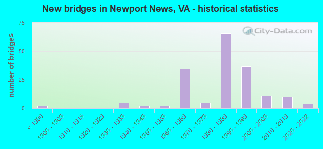
- New bridges - historical statistics
- 2Before 1900
- 51930-1939
- 21940-1949
- 21950-1959
- 351960-1969
- 51970-1979
- 661980-1989
- 371990-1999
- 112000-2009
- 102010-2019
- 42020-2022

- Reconstructed bridges - Historical Statistics
- 11940-1949
- 01950-1959
- 01960-1969
- 11970-1979
- 61980-1989
- 01990-1999
- 12000-2009
- 102010-2019


- Bridge Condition - Deck
- 9.4%Very good
- 58.8%Good
- 25.9%Satisfactory
- 5.9%Fair

- Bridge Condition - Superstructure
- 1.2%Excellent
- 8.2%Very good
- 50.6%Good
- 30.6%Satisfactory
- 8.2%Fair
- 1.2%Poor

- Bridge Condition - Substructure
- 1.2%Excellent
- 9.4%Very good
- 36.5%Good
- 47.1%Satisfactory
- 5.9%Fair

- Bridge Condition - Channel
- 43.2%Very good
- 25.0%Good
- 27.3%Satisfactory
- 4.5%Fair

- Bridge Condition - Culverts
- 26.7%Good
- 73.3%Satisfactory
Find on map >> Show street view
Structure Number: 155, Location: 1.05-Rt.655 / 0.65-Rt.610 (Lat: 37.670139, Lng: -79.093469), Route carried "on" structure: County highway 778, Year Built: 1939, Status: Open, Structure Length: 2.97m (9.74ft), Average Daily Traffic: 696 (year 2020), Truck Traffic: 5%, Average Future Daily Traffic: 910 (year 2040), Features Intersected: Mill Creek, Facility Carried by Structure: Lowesville Road
Minimum Vertical Clearance: 30+ m (98+ ft), Kilometerpoint: 4.763, Lanes on structure: 2, Owner: State Highway Agency, Approaching Roadway Width: 6.4m (21.0ft), Material/Design: Concrete, Design/Construction: Tee Beam, Number Of Spans In Main Unit: 3, Length of Maximum Span: 9.1m (29.9ft), Curb or Sidewalk Widths: Left: 0.2m (0.7ft), Right: 0.2m (0.7ft), Curb-To-Curb Width: 7.0m (23.0ft), Out-to-Out Width: 8.3m (27.2ft)
Condition: Deck: Fair, Superstructure: Fair, Substructure: Satisfactory, Channel: Very good, Operating Rating: 49.0 metric tons, Method Used To Determine Operating Rating: Load Factor (LF), Inventory Rating: 29.0 metric tons, Method Used To Determine Inventory Rating: Load Factor (LF), Structural Evaluation: Somewhat better than minimum adequacy, Deck Geometry: Meets minimum limits, Waterway Adequacy: Better than present minimum criteria, Approach Roadway Alignment: Better than present minimum criteria, Length Of Structure Improvement: 3.75m (12.30ft), Designated Inspection Frequency: Every 24 months, Inspection Date: August 2021, Bridge Improvement Cost: $379,000, Roadway Improvement Cost: $38,000, Total Project Cost: $563,000, Deck Structure Type: Concrete Cast-file-Place, Wearing Surface/Protective System: Wearing Surface: Bituminous
Find on map >> Show street view
Structure Number: 2552, Location: 0.05 TO 39 & 1.75 TO 629 (Lat: 38.046983, Lng: -79.708764), Route carried "on" structure: County highway 683, Year Built: 1932, Status: Open, Structure Length: 1.21m (3.97ft), Average Daily Traffic: 42 (year 2018), Average Future Daily Traffic: 48 (year 2040), Features Intersected: THOMPSON CREEK, Facility Carried by Structure: BLU GRASS HLLOW RD
Minimum Vertical Clearance: 30+ m (98+ ft), Kilometerpoint: 2.804, Lanes on structure: 1, Owner: State Highway Agency, Approaching Roadway Width: 3.7m (12.1ft), Material/Design: Steel, Design/Construction: Stringer/Multi-beam, Number Of Spans In Main Unit: 1, Length of Maximum Span: 11.3m (37.1ft), Curb or Sidewalk Widths: Left: 0.2m (0.7ft), Right: 0.2m (0.7ft), Curb-To-Curb Width: 3.7m (12.1ft), Out-to-Out Width: 4.4m (14.4ft)
Condition: Deck: Good, Superstructure: Satisfactory, Substructure: Satisfactory, Channel: Fair, Operating Rating: 38.1 metric tons, Method Used To Determine Operating Rating: Load Factor (LF), Inventory Rating: 22.7 metric tons, Method Used To Determine Inventory Rating: Load Factor (LF), Structural Evaluation: Equal to present minimum criteria, Deck Geometry: Meets minimum limits, Waterway Adequacy: Better than present minimum criteria, Approach Roadway Alignment: Equal to present minimum criteria, Designated Inspection Frequency: Every 24 months, Inspection Date: March 2020, Deck Structure Type: Wood or Timber
Find on map >> Show street view
Structure Number: 3969, Location: 0.0 TO R624&0.1 TO END MA (Lat: 37.198661, Lng: -82.007756), Route carried "on" structure: County highway 682, Year Built: 1988, Status: Open, Structure Length: 1.10m (3.61ft), Average Daily Traffic: 125 (year 2008), Average Future Daily Traffic: 145 (year 2040), Design Load: HS 20+Mod, Features Intersected: GARDEN CREEK, Facility Carried by Structure: SPLITLOG ROAD
Minimum Vertical Clearance: 30+ m (98+ ft), Kilometerpoint: 0.183, Lanes on structure: 2, Owner: State Highway Agency, Approaching Roadway Width: 7.6m (24.9ft), Material/Design: Concrete, Design/Construction: Slab, Number Of Spans In Main Unit: 1, Length of Maximum Span: 10.3m (33.8ft), Curb or Sidewalk Widths: Left: 0.2m (0.7ft), Right: 0.2m (0.7ft), Curb-To-Curb Width: 7.6m (24.9ft), Out-to-Out Width: 8.5m (27.9ft)
Condition: Deck: Good, Superstructure: Good, Substructure: Satisfactory, Channel: Very good, Operating Rating: 88.9 metric tons, Method Used To Determine Operating Rating: Load and Resistance Factor (LRFR), Inventory Rating: 68.9 metric tons, Method Used To Determine Inventory Rating: Load and Resistance Factor (LRFR), Structural Evaluation: Equal to present minimum criteria, Deck Geometry: Somewhat better than minimum adequacy, Waterway Adequacy: Equal to present minimum criteria, Approach Roadway Alignment: High priority of corrective action, Length Of Structure Improvement: 1.10m (3.61ft), Designated Inspection Frequency: Every 24 months, Inspection Date: August 2020, Bridge Improvement Cost: $30,000, Roadway Improvement Cost: $10,000, Total Project Cost: $50,000, Deck Structure Type: Concrete Cast-file-Place, Wearing Surface/Protective System: Deck Protection: Epoxy Coated Reinforcing
Find on map >> Show street view
Structure Number: 10489, Location: 0.89 Mi To York Co Line (Lat: 37.224167, Lng: -76.614550), Route carried "on" structure: Interstate 64, Year Built: 1965, Status: Open, Structure Length: 8.21m (26.94ft), Average Daily Traffic: 37,377 (year 2020), Truck Traffic: 4%, Average Future Daily Traffic: 52,328 (year 2040), Design Load: HS 20+Mod, Features Intersected: Ac Rd & RR @ Weapons Sta
Minimum Vertical Clearance: 30+ m (98+ ft), Kilometerpoint: 395.074, Lanes on structure: 3, Lanes under structure: 3, Base Highway Network: Yes, Owner: State Highway Agency, Approaching Roadway Width: 19.4m (63.6ft), Skew: 3 degrees, Material/Design: Steel, Design/Construction: Stringer/Multi-beam, Number Of Spans In Main Unit: 4, Length of Maximum Span: 21.3m (69.9ft), Curb-To-Curb Width: 19.4m (63.6ft), Out-to-Out Width: 20.4m (66.9ft)
Condition: Deck: Good, Superstructure: Good, Substructure: Good, Operating Rating: 77.1 metric tons, Method Used To Determine Operating Rating: Load and Resistance Factor (LRFR), Inventory Rating: 59.0 metric tons, Method Used To Determine Inventory Rating: Load and Resistance Factor (LRFR), Structural Evaluation: Better than present minimum criteria, Deck Geometry: Superior to present desirable criteria, Underclear: Equal to present minimum criteria, Approach Roadway Alignment: Equal to present desirable criteria, Length Of Structure Improvement: 9.14m (29.99ft), Designated Inspection Frequency: Every 24 months, Inspection Date: March 2021, Bridge Improvement Cost: $1,125,000, Roadway Improvement Cost: $100,000, Total Project Cost: $2,100,000 ( Estimate for 2018), Deck Structure Type: Concrete Cast-file-Place, Wearing Surface/Protective System: Wearing Surface: Latex Concrete
Find on map >> Show street view
Structure Number: 10491, Location: 0.88 Mi Fr York Co Line (Lat: 37.224492, Lng: -76.614506), Route carried "on" structure: Interstate 64, Year Built: 1965, Year Reconstructed: 2019, Status: Open, Structure Length: 7.63m (25.03ft), Average Daily Traffic: 39,576 (year 2020), Truck Traffic: 4%, Average Future Daily Traffic: 55,406 (year 2040), Design Load: HS 20+Mod, Features Intersected: Ac Rd & RR @ Weapons Sta
Minimum Vertical Clearance: 30+ m (98+ ft), Kilometerpoint: 395.074, Lanes on structure: 3, Lanes under structure: 2, Base Highway Network: Yes, Owner: State Highway Agency, Approaching Roadway Width: 19.1m (62.7ft), Skew: 3 degrees, Material/Design: Steel, Design/Construction: Stringer/Multi-beam, Number Of Spans In Main Unit: 4, Length of Maximum Span: 18.9m (62.0ft), Curb-To-Curb Width: 19.1m (62.7ft), Out-to-Out Width: 20.1m (65.9ft)
Condition: Deck: Good, Superstructure: Good, Substructure: Good, Operating Rating: 72.6 metric tons, Method Used To Determine Operating Rating: Load and Resistance Factor (LRFR), Inventory Rating: 56.2 metric tons, Method Used To Determine Inventory Rating: Load and Resistance Factor (LRFR), Structural Evaluation: Better than present minimum criteria, Deck Geometry: Superior to present desirable criteria, Underclear: Meets minimum limits, Approach Roadway Alignment: Equal to present desirable criteria, Length Of Structure Improvement: 9.14m (29.99ft), Designated Inspection Frequency: Every 24 months, Inspection Date: March 2021, Bridge Improvement Cost: $1,125,000, Roadway Improvement Cost: $100,000, Total Project Cost: $2,100,000 ( Estimate for 2018), Deck Structure Type: Concrete Cast-file-Place, Wearing Surface/Protective System: Wearing Surface: Latex Concrete
Find on map >> Show street view
Structure Number: 10493, Location: 0.02 Mi To Newport News (Lat: 37.215083, Lng: -76.592392), Route carried "on" structure: Interstate 64, Year Built: 1965, Status: Open, Structure Length: 0.73m (2.40ft), Average Daily Traffic: 72,021 (year 2020), Truck Traffic: 4%, Average Future Daily Traffic: 91,567 (year 2040), Design Load: HS 20, Features Intersected: Blows Mill Run
Minimum Vertical Clearance: 30+ m (98+ ft), Kilometerpoint: 393.964, Lanes on structure: 4, Base Highway Network: Yes, Owner: State Highway Agency, Approaching Roadway Width: 15.2m (49.9ft), Material/Design: Concrete, Design/Construction: Culvert, Number Of Spans In Main Unit: 4, Length of Maximum Span: 1.8m (5.9ft)
Condition: Channel: Satisfactory, Culverts: Satisfactory, Operating Rating: 89.8 metric tons, Method Used To Determine Operating Rating: Load Factor (LF), Inventory Rating: 89.8 metric tons, Method Used To Determine Inventory Rating: Load Factor (LF), Structural Evaluation: Equal to present minimum criteria, Waterway Adequacy: Equal to present desirable criteria, Approach Roadway Alignment: Equal to present desirable criteria, Designated Inspection Frequency: Every 24 months, Inspection Date: January 2022
Find on map >> Show street view
Structure Number: 16989, Location: 0.06 TO 11 - 0.55 TO 761 (Lat: 38.992272, Lng: -78.358203), Route carried "on" structure: State highway 55, Year Built: 1947, Status: Open, Structure Length: 0.91m (2.99ft), Average Daily Traffic: 3,924 (year 2020), Truck Traffic: 4%, Average Future Daily Traffic: 4,316 (year 2040), Design Load: H 15, Features Intersected: TOWN RUN, Facility Carried by Structure: JOHN MARSHALL HWY
Minimum Vertical Clearance: 30+ m (98+ ft), Kilometerpoint: 25.462, Lanes on structure: 2, Base Highway Network: Yes, Owner: State Highway Agency, Approaching Roadway Width: 7.0m (23.0ft), Skew: 1 degrees, Material/Design: Concrete, Design/Construction: Arch - Deck, Number Of Spans In Main Unit: 2, Length of Maximum Span: 3.7m (12.1ft), Curb-To-Curb Width: 8.5m (27.9ft), Out-to-Out Width: 20.1m (65.9ft)
Condition: Deck: Satisfactory, Superstructure: Satisfactory, Substructure: Very good, Channel: Very good, Operating Rating: 72.3 metric tons, Method Used To Determine Operating Rating: Load and Resistance Factor (LRFR), Inventory Rating: 60.8 metric tons, Method Used To Determine Inventory Rating: Load and Resistance Factor (LRFR), Structural Evaluation: Equal to present minimum criteria, Deck Geometry: Meets minimum limits, Waterway Adequacy: Equal to present minimum criteria, Approach Roadway Alignment: Equal to present desirable criteria, Designated Inspection Frequency: Every 24 months, Inspection Date: June 2020, Deck Structure Type: Concrete Cast-file-Place, Wearing Surface/Protective System: Wearing Surface: Bituminous
Find on map >> Show street view
Structure Number: 19853, Location: 0.02 Mi Fr Int Rte 17 (Lat: 37.127458, Lng: -76.459239), Route carried "on" structure: State highway 134, Year Built: 1965, Status: Open, Structure Length: 8.53m (27.99ft), Average Daily Traffic: 13,562 (year 2020), Truck Traffic: 1%, Average Future Daily Traffic: 14,918 (year 2040), Design Load: HS 20+Mod, Features Intersected: Route 17, Facility Carried by Structure: Magruder Blvd
Minimum Vertical Clearance: 30+ m (98+ ft), Kilometerpoint: 0.536, Lanes on structure: 2, Lanes under structure: 4, Base Highway Network: Yes, Owner: State Highway Agency, Approaching Roadway Width: 14.9m (48.9ft), Skew: 24 degrees, Material/Design: Steel, Design/Construction: Stringer/Multi-beam, Number Of Spans In Main Unit: 4, Length of Maximum Span: 22.6m (74.1ft), Curb or Sidewalk Widths: Left: 0.5m (1.6ft), Right: 0.5m (1.6ft), Curb-To-Curb Width: 12.2m (40.0ft), Out-to-Out Width: 19.8m (65.0ft)
Condition: Deck: Fair, Superstructure: Satisfactory, Substructure: Satisfactory, Operating Rating: 68.0 metric tons, Method Used To Determine Operating Rating: Load and Resistance Factor (LRFR), Inventory Rating: 52.6 metric tons, Method Used To Determine Inventory Rating: Load and Resistance Factor (LRFR), Structural Evaluation: Equal to present minimum criteria, Deck Geometry: Somewhat better than minimum adequacy, Underclear: Somewhat better than minimum adequacy, Approach Roadway Alignment: Better than present minimum criteria, Length Of Structure Improvement: 8.84m (29.00ft), Designated Inspection Frequency: Every 24 months, Inspection Date: August 2020, Bridge Improvement Cost: $1,700,000, Roadway Improvement Cost: $140,000, Total Project Cost: $4,000,000, Deck Structure Type: Concrete Cast-file-Place, Wearing Surface/Protective System: Wearing Surface: Epoxy Overlay, Membrane: Epoxy
Find on map >> Show street view
Structure Number: 20641, Location: 1.08 Mi Fr Jefferson Ave (Lat: 37.082283, Lng: -76.454261), Route carried "on" structure: City street , Year Built: 1960, Year Reconstructed: 2000, Status: Open, Structure Length: 7.32m (24.02ft), Average Daily Traffic: 8,257 (year 2020), Truck Traffic: 2%, Average Future Daily Traffic: 9,083 (year 2040), Design Load: HS 20+Mod, Features Intersected: IS 64, Facility Carried by Structure: Harpersville Road
Minimum Vertical Clearance: 30+ m (98+ ft), Kilometerpoint: 0.000, Lanes on structure: 2, Lanes under structure: 10, Owner: State Highway Agency, Approaching Roadway Width: 9.4m (30.8ft), Skew: 2 degrees, Material/Design: Steel continuous, Design/Construction: Stringer/Multi-beam, Number Of Spans In Main Unit: 2, Length of Maximum Span: 36.6m (120.1ft), Curb or Sidewalk Widths: Left: 1.5m (4.9ft), Right: 1.5m (4.9ft), Curb-To-Curb Width: 12.2m (40.0ft), Out-to-Out Width: 13.0m (42.7ft)
Condition: Deck: Good, Superstructure: Good, Substructure: Satisfactory, Operating Rating: 69.7 metric tons, Method Used To Determine Operating Rating: Load and Resistance Factor (LRFR), Inventory Rating: 53.7 metric tons, Method Used To Determine Inventory Rating: Load and Resistance Factor (LRFR), Structural Evaluation: Equal to present minimum criteria, Deck Geometry: Somewhat better than minimum adequacy, Underclear: Somewhat better than minimum adequacy, Approach Roadway Alignment: Equal to present desirable criteria, Length Of Structure Improvement: 8.69m (28.51ft), Designated Inspection Frequency: Every 24 months, Inspection Date: May 2020, Bridge Improvement Cost: $825,000, Roadway Improvement Cost: $35,000, Total Project Cost: $1,145,000, Deck Structure Type: Concrete Cast-file-Place, Wearing Surface/Protective System: Wearing Surface: Monolithic Concrete, Deck Protection: Epoxy Coated Reinforcing
Find on map >> Show street view
Structure Number: 20643, Location: 1.00 Mi To Rt 17 (Lat: 37.105361, Lng: -76.472531), Route carried "on" structure: City street 7034, Year Built: 1991, Status: Open, Structure Length: 9.57m (31.40ft), Average Daily Traffic: 5,031 (year 2020), Average Future Daily Traffic: 5,534 (year 2040), Design Load: HS 20+Mod, Features Intersected: IS 64, Facility Carried by Structure: Old Oyster Pt Rd
Minimum Vertical Clearance: 30+ m (98+ ft), Kilometerpoint: 0.000, Lanes on structure: 2, Lanes under structure: 8, Owner: State Highway Agency, Approaching Roadway Width: 12.2m (40.0ft), Skew: 3 degrees, Material/Design: Steel continuous, Design/Construction: Stringer/Multi-beam, Number Of Spans In Main Unit: 4, Length of Maximum Span: 34.4m (112.9ft), Curb-To-Curb Width: 11.6m (38.1ft), Out-to-Out Width: 12.2m (40.0ft)
Condition: Deck: Satisfactory, Superstructure: Good, Substructure: Fair, Operating Rating: 96.2 metric tons, Method Used To Determine Operating Rating: Load and Resistance Factor (LRFR), Inventory Rating: 73.5 metric tons, Method Used To Determine Inventory Rating: Load and Resistance Factor (LRFR), Structural Evaluation: Somewhat better than minimum adequacy, Deck Geometry: Somewhat better than minimum adequacy, Underclear: Equal to present minimum criteria, Approach Roadway Alignment: Equal to present desirable criteria, Length Of Structure Improvement: 9.54m (31.30ft), Designated Inspection Frequency: Every 24 months, Inspection Date: October 2020, Bridge Improvement Cost: $991,000, Roadway Improvement Cost: $25,000, Total Project Cost: $1,018,000, Deck Structure Type: Concrete Cast-file-Place, Wearing Surface/Protective System: Wearing Surface: Monolithic Concrete, Deck Protection: Epoxy Coated Reinforcing
Find on map >> Show street view
Structure Number: 20645, Location: 1.0 Mi Fr Rte 143 (Lat: 37.108403, Lng: -76.476394), Route carried "on" structure: State highway 171, Year Built: 1990, Status: Open, Structure Length: 10.70m (35.10ft), Average Daily Traffic: 41,694 (year 2020), Average Future Daily Traffic: 58,372 (year 2040), Design Load: HS 20+Mod, Features Intersected: IS 64, Facility Carried by Structure: Oyster Point Road
Minimum Vertical Clearance: 30+ m (98+ ft), Kilometerpoint: 1.850, Lanes on structure: 8, Lanes under structure: 10, Base Highway Network: Yes, Owner: State Highway Agency, Approaching Roadway Width: 16.2m (53.1ft), Skew: 20 degrees, Material/Design: Steel, Design/Construction: Stringer/Multi-beam, Number Of Spans In Main Unit: 3, Length of Maximum Span: 42.7m (140.1ft), Curb or Sidewalk Widths: Left: 0.2m (0.7ft), Right: 0.2m (0.7ft), Curb-To-Curb Width: 36.0m (118.1ft), Out-to-Out Width: 37.0m (121.4ft)
Condition: Deck: Good, Superstructure: Good, Substructure: Satisfactory, Operating Rating: 71.7 metric tons, Method Used To Determine Operating Rating: Load and Resistance Factor (LRFR), Inventory Rating: 55.3 metric tons, Method Used To Determine Inventory Rating: Load and Resistance Factor (LRFR), Structural Evaluation: Equal to present minimum criteria, Deck Geometry: Superior to present desirable criteria, Underclear: Somewhat better than minimum adequacy, Approach Roadway Alignment: Equal to present desirable criteria, Designated Inspection Frequency: Every 24 months, Inspection Date: August 2020, Deck Structure Type: Concrete Cast-file-Place, Wearing Surface/Protective System: Wearing Surface: Epoxy Overlay, Deck Protection: Epoxy Coated Reinforcing
Find on map >> Show street view
Structure Number: 20647, Location: 0.14 Mi To Huntington Ave (Lat: 36.985011, Lng: -76.430656), Route carried "on" structure: City street , Year Built: 1988, Status: Open, Structure Length: 36.42m (119.49ft), Average Daily Traffic: 2,424 (year 2020), Average Future Daily Traffic: 3,027 (year 2040), Design Load: HS 20+Mod, Features Intersected: IS 664; Route 60 & CSX, Facility Carried by Structure: 34th St EBL
Minimum Vertical Clearance: 30+ m (98+ ft), Kilometerpoint: 0.000, Lanes on structure: 3, Lanes under structure: 11, Base Highway Network: Yes, Owner: State Highway Agency, Approaching Roadway Width: 11.6m (38.1ft), Skew: 9 degrees, Material/Design: Steel, Design/Construction: Stringer/Multi-beam, Number Of Spans In Main Unit: 12, Length of Maximum Span: 52.7m (172.9ft), Curb or Sidewalk Widths: Left: 2.4m (7.9ft), Right: 0.0m, Curb-To-Curb Width: 14.8m (48.6ft), Out-to-Out Width: 18.1m (59.4ft)
Condition: Deck: Satisfactory, Superstructure: Good, Substructure: Satisfactory, Operating Rating: 73.3 metric tons, Method Used To Determine Operating Rating: Load and Resistance Factor (LRFR), Inventory Rating: 56.5 metric tons, Method Used To Determine Inventory Rating: Load and Resistance Factor (LRFR), Structural Evaluation: Equal to present minimum criteria, Deck Geometry: Meets minimum limits, Underclear: High priority of corrective action, Approach Roadway Alignment: Equal to present desirable criteria, Designated Inspection Frequency: Every 24 months, Inspection Date: May 2021, Deck Structure Type: Concrete Cast-file-Place, Wearing Surface/Protective System: Wearing Surface: Monolithic Concrete, Deck Protection: Epoxy Coated Reinforcing
Find on map >> Show street view
Structure Number: 20649, Location: 0.14 Mi To Huntington Ave (Lat: 36.985136, Lng: -76.430661), Route carried "on" structure: City street , Year Built: 1988, Status: Open, Structure Length: 36.52m (119.82ft), Average Daily Traffic: 2,500 (year 2012), Truck Traffic: 4%, Average Future Daily Traffic: 3,899 (year 2040), Design Load: HS 20+Mod, Features Intersected: I-664; Route 60 & CSX, Facility Carried by Structure: 34th St WBL
Minimum Vertical Clearance: 30+ m (98+ ft), Kilometerpoint: 0.000, Lanes on structure: 3, Lanes under structure: 11, Base Highway Network: Yes, Owner: State Highway Agency, Approaching Roadway Width: 9.4m (30.8ft), Skew: 9 degrees, Material/Design: Steel, Design/Construction: Stringer/Multi-beam, Number Of Spans In Main Unit: 13, Length of Maximum Span: 49.7m (163.1ft), Curb-To-Curb Width: 9.3m (30.5ft), Out-to-Out Width: 10.2m (33.5ft)
Condition: Deck: Satisfactory, Superstructure: Good, Substructure: Satisfactory, Operating Rating: 50.3 metric tons, Method Used To Determine Operating Rating: Load and Resistance Factor (LRFR), Inventory Rating: 38.8 metric tons, Method Used To Determine Inventory Rating: Load and Resistance Factor (LRFR), Structural Evaluation: Equal to present minimum criteria, Deck Geometry: High priority of replacement, Underclear: Somewhat better than minimum adequacy, Approach Roadway Alignment: Equal to present desirable criteria, Length Of Structure Improvement: 57.91m (189.99ft), Designated Inspection Frequency: Every 24 months, Inspection Date: May 2021, Bridge Improvement Cost: $6,555,000, Roadway Improvement Cost: $131,000, Total Project Cost: $6,786,000 ( Estimate for 2015), Deck Structure Type: Concrete Cast-file-Place, Wearing Surface/Protective System: Wearing Surface: Monolithic Concrete, Deck Protection: Epoxy Coated Reinforcing
Find on map >> Show street view
Structure Number: 20651, Location: 0.11 Mi Fr Rte 60 (Lat: 36.980739, Lng: -76.423411), Route carried "on" structure: City street , Year Built: 1987, Status: Open, Structure Length: 33.77m (110.79ft), Average Daily Traffic: 551 (year 2020), Truck Traffic: 5%, Average Future Daily Traffic: 771 (year 2040), Design Load: HS 20+Mod, Features Intersected: IS 664; Route 60 & CSX, Facility Carried by Structure: 26th Street
Minimum Vertical Clearance: 30.45m (99.90ft), Kilometerpoint: 0.000, Lanes on structure: 2, Lanes under structure: 10, Owner: State Highway Agency, Approaching Roadway Width: 11.9m (39.0ft), Skew: 9 degrees, Material/Design: Steel continuous, Design/Construction: Stringer/Multi-beam, Number Of Spans In Main Unit: 9, Length of Maximum Span: 45.1m (148.0ft), Curb-To-Curb Width: 11.1m (36.4ft), Out-to-Out Width: 12.1m (39.7ft)
Condition: Deck: Good, Superstructure: Satisfactory, Substructure: Fair, Operating Rating: 68.0 metric tons, Method Used To Determine Operating Rating: Load and Resistance Factor (LRFR), Inventory Rating: 52.6 metric tons, Method Used To Determine Inventory Rating: Load and Resistance Factor (LRFR), Structural Evaluation: Somewhat better than minimum adequacy, Deck Geometry: Equal to present minimum criteria, Underclear: High priority of corrective action, Approach Roadway Alignment: Equal to present desirable criteria, Length Of Structure Improvement: 3.66m (12.01ft), Designated Inspection Frequency: Every 24 months, Inspection Date: October 2021, Bridge Improvement Cost: $800,000, Roadway Improvement Cost: $25,000, Total Project Cost: $850,000 ( Estimate for 2018), Deck Structure Type: Concrete Cast-file-Place, Wearing Surface/Protective System: Wearing Surface: Monolithic Concrete, Deck Protection: Epoxy Coated Reinforcing
Find on map >> Show street view
Structure Number: 20653, Location: 0.14 Mi To Huntington Ave (Lat: 36.978214, Lng: -76.426317), Route carried "on" structure: City street , Year Built: 1988, Status: Open, Structure Length: 33.65m (110.40ft), Average Daily Traffic: 3,801 (year 2020), Truck Traffic: 2%, Average Future Daily Traffic: 5,321 (year 2040), Design Load: HS 20+Mod, Features Intersected: I-664; Route 60 & CSX, Facility Carried by Structure: 23rd - 25th St
Minimum Vertical Clearance: 6.71m (22.01ft), Kilometerpoint: 0.000, Lanes on structure: 4, Lanes under structure: 10, Base Highway Network: Yes, Owner: State Highway Agency, Approaching Roadway Width: 10.7m (35.1ft), Skew: 9 degrees, Material/Design: Steel, Design/Construction: Stringer/Multi-beam, Number Of Spans In Main Unit: 11, Length of Maximum Span: 51.2m (168.0ft), Curb or Sidewalk Widths: Left: 2.4m (7.9ft), Right: 0.0m, Curb-To-Curb Width: 10.7m (35.1ft), Out-to-Out Width: 11.7m (38.4ft)
Condition: Deck: Satisfactory, Superstructure: Satisfactory, Substructure: Satisfactory, Operating Rating: 70.2 metric tons, Method Used To Determine Operating Rating: Load and Resistance Factor (LRFR), Inventory Rating: 54.2 metric tons, Method Used To Determine Inventory Rating: Load and Resistance Factor (LRFR), Structural Evaluation: Equal to present minimum criteria, Deck Geometry: High priority of replacement, Underclear: High priority of replacement, Approach Roadway Alignment: Equal to present desirable criteria, Length Of Structure Improvement: 71.87m (235.79ft), Designated Inspection Frequency: Every 24 months, Inspection Date: May 2021, Bridge Improvement Cost: $4,500,000, Roadway Improvement Cost: $4,000,000, Total Project Cost: $8,600,000 ( Estimate for 2014), Deck Structure Type: Concrete Precast Panels, Wearing Surface/Protective System: Wearing Surface: Epoxy Overlay, Deck Protection: Epoxy Coated Reinforcing
Find on map >> Show street view
Structure Number: 20658, Location: 0.90 TO 258/ 0.25N BRIARF (Lat: 37.014639, Lng: -76.423586), Route carried "on" structure: City street , Year Built: 1960, Year Reconstructed: 2016, Status: Temporarily open, Structure Length: 1.01m (3.31ft), Average Daily Traffic: 6,359 (year 2020), Average Future Daily Traffic: 6,995 (year 2040), Design Load: HS 20, Features Intersected: Newmarket Creek, Facility Carried by Structure: Chestnut Ave.
Minimum Vertical Clearance: 30+ m (98+ ft), Kilometerpoint: 0.000, Lanes on structure: 4, Owner: City or Municipal Highway Agency, Approaching Roadway Width: 7.3m (24.0ft), Skew: 20 degrees, Material/Design: Concrete, Design/Construction: Culvert, Number Of Spans In Main Unit: 4, Length of Maximum Span: 2.1m (6.9ft)
Condition: Channel: Good, Culverts: Satisfactory, Operating Rating: 33.5 metric tons, Method Used To Determine Operating Rating: Load and Resistance Factor (LRFR), Inventory Rating: 20.0 metric tons, Method Used To Determine Inventory Rating: Load and Resistance Factor (LRFR), Structural Evaluation: Somewhat better than minimum adequacy, Waterway Adequacy: Better than present minimum criteria, Approach Roadway Alignment: Better than present minimum criteria, Length Of Structure Improvement: 3.05m (10.01ft), Designated Inspection Frequency: Every 24 months, Inspection Date: July 2020, Bridge Improvement Cost: $100,000, Roadway Improvement Cost: $25,000, Total Project Cost: $150,000 ( Estimate for 2016)
Find on map >> Show street view
Structure Number: 20661, Location: 0.04 TO 351/0.40 41ST ST (Lat: 36.988136, Lng: -76.434547), Route carried "on" structure: City street , Year Built: 1899, Year Reconstructed: 2019, Status: Open, Structure Length: 1.71m (5.61ft), Average Daily Traffic: 4,613 (year 2020), Truck Traffic: 2%, Average Future Daily Traffic: 6,460 (year 2040), Design Load: HS 20+Mod, Features Intersected: NNS&DD (PRIVATE) R/R, Facility Carried by Structure: HUNTINGTON AVE.
Minimum Vertical Clearance: 30+ m (98+ ft), Kilometerpoint: 0.000, Lanes on structure: 3, Base Highway Network: Yes, Owner: City or Municipal Highway Agency, Approaching Roadway Width: 13.4m (44.0ft), Material/Design: Steel, Design/Construction: Stringer/Multi-beam, Number Of Spans In Main Unit: 1, Length of Maximum Span: 17.1m (56.1ft), Curb or Sidewalk Widths: Left: 3.0m (9.8ft), Right: 3.0m (9.8ft), Curb-To-Curb Width: 14.9m (48.9ft), Out-to-Out Width: 21.0m (68.9ft)
Condition: Deck: Very good, Superstructure: Very good, Substructure: Good, Channel: Good, Operating Rating: 73.5 metric tons, Method Used To Determine Operating Rating: Load and Resistance Factor (LRFR), Inventory Rating: 56.7 metric tons, Method Used To Determine Inventory Rating: Load and Resistance Factor (LRFR), Structural Evaluation: Better than present minimum criteria, Deck Geometry: Equal to present minimum criteria, Underclear: High priority of replacement, Approach Roadway Alignment: Equal to present minimum criteria, Length Of Structure Improvement: 1.83m (6.00ft), Designated Inspection Frequency: Every 24 months, Inspection Date: Febuary 2021, Bridge Improvement Cost: $294,000, Roadway Improvement Cost: $29,000, Total Project Cost: $441,000 ( Estimate for 2017), Deck Structure Type: Concrete Cast-file-Place, Wearing Surface/Protective System: Wearing Surface: Monolithic Concrete
Find on map >> Show street view
Structure Number: 20666, Location: 0.09 TO 60 / 0.78MENCH RD (Lat: 37.103597, Lng: -76.513339), Route carried "on" structure: City street , Year Built: 1978, Status: Open, Structure Length: 0.70m (2.30ft), Average Daily Traffic: 11,036 (year 2020), Truck Traffic: 2%, Average Future Daily Traffic: 11,701 (year 2040), Design Load: HS 20+Mod, Features Intersected: Deep Creek Branch, Facility Carried by Structure: Boxley Blvd.
Minimum Vertical Clearance: 30+ m (98+ ft), Kilometerpoint: 0.000, Lanes on structure: 4, Owner: City or Municipal Highway Agency, Approaching Roadway Width: 27.4m (89.9ft), Skew: 21 degrees, Material/Design: Concrete, Design/Construction: Culvert, Number Of Spans In Main Unit: 2, Length of Maximum Span: 3.0m (9.8ft)
Condition: Channel: Good, Culverts: Satisfactory, Operating Rating: 40.6 metric tons, Method Used To Determine Operating Rating: Load and Resistance Factor (LRFR), Inventory Rating: 24.2 metric tons, Method Used To Determine Inventory Rating: Load and Resistance Factor (LRFR), Structural Evaluation: Somewhat better than minimum adequacy, Waterway Adequacy: Better than present minimum criteria, Approach Roadway Alignment: Better than present minimum criteria, Designated Inspection Frequency: Every 24 months, Inspection Date: January 2021
Find on map >> Show street view
Structure Number: 20667, Location: 0.47 TO 60 /0.54 TO 143 (Lat: 37.105936, Lng: -76.503997), Route carried "on" structure: City street , Year Built: 1981, Status: Open, Structure Length: 6.95m (22.80ft), Average Daily Traffic: 30,298 (year 2020), Truck Traffic: 1%, Average Future Daily Traffic: 33,328 (year 2040), Design Load: HS 20+Mod, Features Intersected: CSX RAILWAY, Facility Carried by Structure: OYSTER POINT ROAD
Minimum Vertical Clearance: 30+ m (98+ ft), Kilometerpoint: 0.000, Lanes on structure: 4, Base Highway Network: Yes, Owner: City or Municipal Highway Agency, Approaching Roadway Width: 26.2m (86.0ft), Skew: 24 degrees, Material/Design: Steel, Design/Construction: Stringer/Multi-beam, Number Of Spans In Main Unit: 3, Length of Maximum Span: 27.7m (90.9ft), Curb or Sidewalk Widths: Left: 1.5m (4.9ft), Right: 1.5m (4.9ft), Curb-To-Curb Width: 21.3m (69.9ft), Out-to-Out Width: 25.0m (82.0ft)
Condition: Deck: Satisfactory, Superstructure: Satisfactory, Substructure: Satisfactory, Operating Rating: 79.8 metric tons, Method Used To Determine Operating Rating: Load and Resistance Factor (LRFR), Inventory Rating: 61.6 metric tons, Method Used To Determine Inventory Rating: Load and Resistance Factor (LRFR), Structural Evaluation: Equal to present minimum criteria, Deck Geometry: Superior to present desirable criteria, Approach Roadway Alignment: Equal to present desirable criteria, Designated Inspection Frequency: Every 24 months, Inspection Date: August 2020, Deck Structure Type: Concrete Cast-file-Place, Wearing Surface/Protective System: Wearing Surface: Monolithic Concrete, Deck Protection: Epoxy Coated Reinforcing
Find on map >> Show street view
Structure Number: 20668, Location: 00.60 TO 60 /00.43 TO 143 (Lat: 37.124383, Lng: -76.518622), Route carried "on" structure: City street , Year Built: 1991, Status: Open, Structure Length: 13.50m (44.29ft), Average Daily Traffic: 28,045 (year 2020), Average Future Daily Traffic: 34,502 (year 2040), Design Load: HS 20+Mod, Features Intersected: I-64 & CSX Railway, Facility Carried by Structure: Bland Blvd.
Minimum Vertical Clearance: 30+ m (98+ ft), Kilometerpoint: 0.000, Lanes on structure: 4, Lanes under structure: 6, Owner: City or Municipal Highway Agency, Approaching Roadway Width: 16.5m (54.1ft), Skew: 20 degrees, Material/Design: Steel continuous, Design/Construction: Stringer/Multi-beam, Number Of Spans In Main Unit: 4, Length of Maximum Span: 35.7m (117.1ft), Curb or Sidewalk Widths: Left: 3.0m (9.8ft), Right: 3.0m (9.8ft), Curb-To-Curb Width: 16.5m (54.1ft), Out-to-Out Width: 28.3m (92.8ft)
Condition: Deck: Good, Superstructure: Good, Substructure: Good, Operating Rating: 57.2 metric tons, Method Used To Determine Operating Rating: Load and Resistance Factor (LRFR), Inventory Rating: 44.2 metric tons, Method Used To Determine Inventory Rating: Load and Resistance Factor (LRFR), Structural Evaluation: Better than present minimum criteria, Deck Geometry: Meets minimum limits, Underclear: Superior to present desirable criteria, Approach Roadway Alignment: Equal to present desirable criteria, Length Of Structure Improvement: 13.72m (45.01ft), Designated Inspection Frequency: Every 24 months, Inspection Date: December 2021, Bridge Improvement Cost: $3,375,000, Roadway Improvement Cost: $100,000, Total Project Cost: $5,062,000, Deck Structure Type: Concrete Cast-file-Place, Wearing Surface/Protective System: Wearing Surface: Monolithic Concrete, Deck Protection: Epoxy Coated Reinforcing
Find on map >> Show street view
Structure Number: 20669, Location: 0.03BLAND BVD/00.25 TO 60 (Lat: 37.121686, Lng: -76.523272), Route carried "on" structure: City street , Year Built: 1991, Status: Open, Structure Length: 1.28m (4.20ft), Average Daily Traffic: 3,550 (year 1988), Truck Traffic: 5%, Average Future Daily Traffic: 5,000 (year 2028), Design Load: HS 20+Mod, Features Intersected: Lucas Creek, Facility Carried by Structure: Campbell Road
Minimum Vertical Clearance: 30+ m (98+ ft), Kilometerpoint: 0.000, Lanes on structure: 2, Owner: City or Municipal Highway Agency, Approaching Roadway Width: 4.9m (16.1ft), Material/Design: Concrete, Design/Construction: Culvert, Number Of Spans In Main Unit: 4, Length of Maximum Span: 3.0m (9.8ft), Curb-To-Curb Width: 9.1m (29.9ft), Out-to-Out Width: 11.0m (36.1ft)
Condition: Channel: Fair, Culverts: Satisfactory, Operating Rating: 40.6 metric tons, Method Used To Determine Operating Rating: Load and Resistance Factor (LRFR), Inventory Rating: 24.2 metric tons, Method Used To Determine Inventory Rating: Load and Resistance Factor (LRFR), Structural Evaluation: Equal to present minimum criteria, Deck Geometry: Meets minimum limits, Waterway Adequacy: Equal to present desirable criteria, Approach Roadway Alignment: Better than present minimum criteria, Designated Inspection Frequency: Every 24 months, Inspection Date: January 2021
Find on map >> Show street view
Structure Number: 2067, Location: 0.25 TO 60 / 0.69 TO 143 (Lat: 37.122569, Lng: -76.522428), Route carried "on" structure: City street , Year Built: 1991, Status: Open, Structure Length: 0.88m (2.89ft), Average Daily Traffic: 28,045 (year 2020), Average Future Daily Traffic: 34,502 (year 2040), Design Load: HS 20+Mod, Features Intersected: Lucas Creek, Facility Carried by Structure: Bland Blvd.
Minimum Vertical Clearance: 30+ m (98+ ft), Kilometerpoint: 0.000, Lanes on structure: 4, Owner: City or Municipal Highway Agency, Approaching Roadway Width: 34.4m (112.9ft), Skew: 4 degrees, Material/Design: Concrete, Design/Construction: Culvert, Number Of Spans In Main Unit: 2, Length of Maximum Span: 3.0m (9.8ft)
Condition: Channel: Satisfactory, Culverts: Good, Operating Rating: 40.6 metric tons, Method Used To Determine Operating Rating: Load and Resistance Factor (LRFR), Inventory Rating: 24.2 metric tons, Method Used To Determine Inventory Rating: Load and Resistance Factor (LRFR), Structural Evaluation: Somewhat better than minimum adequacy, Waterway Adequacy: Equal to present desirable criteria, Approach Roadway Alignment: Superior to present desirable criteria, Designated Inspection Frequency: Every 24 months, Inspection Date: January 2021
Find on map >> Show street view
Structure Number: 20671, Location: 0.16TO 143&258/0.15 TO 60 (Lat: 37.017833, Lng: -76.448958), Route carried "on" structure: US 17, Year Built: 1938, Year Reconstructed: 1992, Status: Open, Structure Length: 14.26m (46.78ft), Average Daily Traffic: 15,569 (year 2020), Truck Traffic: 3%, Average Future Daily Traffic: 21,798 (year 2040), Design Load: HS 20+Mod, Features Intersected: CSX RAILWAY
Minimum Vertical Clearance: 30+ m (98+ ft), Kilometerpoint: 27.852, Lanes on structure: 3, Base Highway Network: Yes, Owner: City or Municipal Highway Agency, Approaching Roadway Width: 7.9m (25.9ft), Material/Design: Steel, Design/Construction: Stringer/Multi-beam, Number Of Spans In Main Unit: 7, Length of Maximum Span: 26.5m (86.9ft), Curb or Sidewalk Widths: Left: 1.5m (4.9ft), Right: 0.5m (1.6ft), Curb-To-Curb Width: 12.2m (40.0ft), Out-to-Out Width: 14.7m (48.2ft)
Condition: Deck: Satisfactory, Superstructure: Satisfactory, Substructure: Good, Operating Rating: 32.0 metric tons, Method Used To Determine Operating Rating: Load and Resistance Factor (LRFR), Inventory Rating: 24.8 metric tons, Method Used To Determine Inventory Rating: Load and Resistance Factor (LRFR), Structural Evaluation: Equal to present minimum criteria, Deck Geometry: Meets minimum limits, Underclear: Meets minimum limits, Approach Roadway Alignment: Equal to present desirable criteria, Designated Inspection Frequency: Every 24 months, Inspection Date: Febuary 2021, Deck Structure Type: Concrete Cast-file-Place, Wearing Surface/Protective System: Wearing Surface: Monolithic Concrete, Deck Protection: Epoxy Coated Reinforcing
Find on map >> Show street view
Structure Number: 20672, Location: 0.16TO143&258/0.15 TO 60 (Lat: 37.017961, Lng: -76.449036), Route carried "on" structure: US 17, Year Built: 1967, Year Reconstructed: 1992, Status: Open, Structure Length: 14.26m (46.78ft), Average Daily Traffic: 15,569 (year 2020), Truck Traffic: 3%, Average Future Daily Traffic: 21,798 (year 2040), Design Load: HS 20+Mod, Features Intersected: CSX RAILWAY
Minimum Vertical Clearance: 30+ m (98+ ft), Kilometerpoint: 27.852, Lanes on structure: 3, Base Highway Network: Yes, Owner: City or Municipal Highway Agency, Approaching Roadway Width: 12.5m (41.0ft), Material/Design: Steel, Design/Construction: Stringer/Multi-beam, Number Of Spans In Main Unit: 7, Length of Maximum Span: 26.5m (86.9ft), Curb or Sidewalk Widths: Left: 1.9m (6.2ft), Right: 0.5m (1.6ft), Curb-To-Curb Width: 12.5m (41.0ft), Out-to-Out Width: 15.3m (50.2ft)
Condition: Deck: Good, Superstructure: Good, Substructure: Good, Operating Rating: 42.1 metric tons, Method Used To Determine Operating Rating: Load and Resistance Factor (LRFR), Inventory Rating: 32.5 metric tons, Method Used To Determine Inventory Rating: Load and Resistance Factor (LRFR), Structural Evaluation: Better than present minimum criteria, Deck Geometry: Meets minimum limits, Underclear: Meets minimum limits, Approach Roadway Alignment: Equal to present minimum criteria, Designated Inspection Frequency: Every 24 months, Inspection Date: Febuary 2021, Deck Structure Type: Concrete Cast-file-Place, Wearing Surface/Protective System: Wearing Surface: Monolithic Concrete, Deck Protection: Epoxy Coated Reinforcing
Find on map >> Show street view
Structure Number: 20673, Location: 0.30143&258 /0.48JAMES-RV (Lat: 37.017222, Lng: -76.450508), Route carried "on" structure: US 17, Year Built: 1967, Year Reconstructed: 1992, Status: Open, Structure Length: 5.79m (19.00ft), Average Daily Traffic: 15,569 (year 2020), Truck Traffic: 3%, Average Future Daily Traffic: 21,798 (year 2040), Design Load: HS 20+Mod, Features Intersected: RTE 60 (WARWICK ROAD)
Minimum Vertical Clearance: 30+ m (98+ ft), Kilometerpoint: 28.077, Lanes on structure: 3, Lanes under structure: 7, Base Highway Network: Yes, Owner: City or Municipal Highway Agency, Approaching Roadway Width: 12.2m (40.0ft), Material/Design: Steel, Design/Construction: Stringer/Multi-beam, Number Of Spans In Main Unit: 4, Length of Maximum Span: 20.7m (67.9ft), Curb-To-Curb Width: 12.2m (40.0ft), Out-to-Out Width: 13.2m (43.3ft)
Condition: Deck: Satisfactory, Superstructure: Satisfactory, Substructure: Satisfactory, Operating Rating: 82.1 metric tons, Method Used To Determine Operating Rating: Load and Resistance Factor (LRFR), Inventory Rating: 63.3 metric tons, Method Used To Determine Inventory Rating: Load and Resistance Factor (LRFR), Structural Evaluation: Equal to present minimum criteria, Deck Geometry: Meets minimum limits, Underclear: Meets minimum limits, Approach Roadway Alignment: Equal to present minimum criteria, Designated Inspection Frequency: Every 24 months, Inspection Date: Febuary 2021, Deck Structure Type: Concrete Cast-file-Place, Wearing Surface/Protective System: Wearing Surface: Latex Concrete
Find on map >> Show street view
Structure Number: 20675, Location: 0.30143&258 /0.48JAMES-RV (Lat: 37.017333, Lng: -76.450583), Route carried "on" structure: US 17, Year Built: 1967, Year Reconstructed: 1992, Status: Open, Structure Length: 5.79m (19.00ft), Average Daily Traffic: 15,569 (year 2020), Truck Traffic: 3%, Average Future Daily Traffic: 21,798 (year 2040), Design Load: HS 20+Mod, Features Intersected: RTE 60 (WARWICK ROAD)
Minimum Vertical Clearance: 30+ m (98+ ft), Kilometerpoint: 28.077, Lanes on structure: 3, Lanes under structure: 7, Base Highway Network: Yes, Owner: City or Municipal Highway Agency, Approaching Roadway Width: 12.2m (40.0ft), Material/Design: Steel, Design/Construction: Stringer/Multi-beam, Number Of Spans In Main Unit: 4, Length of Maximum Span: 20.7m (67.9ft), Curb-To-Curb Width: 12.2m (40.0ft), Out-to-Out Width: 13.2m (43.3ft)
Condition: Deck: Satisfactory, Superstructure: Satisfactory, Substructure: Satisfactory, Operating Rating: 82.2 metric tons, Method Used To Determine Operating Rating: Load and Resistance Factor (LRFR), Inventory Rating: 63.4 metric tons, Method Used To Determine Inventory Rating: Load and Resistance Factor (LRFR), Structural Evaluation: Equal to present minimum criteria, Deck Geometry: Meets minimum limits, Underclear: Somewhat better than minimum adequacy, Approach Roadway Alignment: Equal to present minimum criteria, Designated Inspection Frequency: Every 24 months, Inspection Date: Febuary 2021, Deck Structure Type: Concrete Cast-file-Place, Wearing Surface/Protective System: Wearing Surface: Latex Concrete
Find on map >> Show street view
Structure Number: 20677, Location: 2.50 TO 306 /0.50143& 258 (Lat: 37.026289, Lng: -76.448939), Route carried "on" structure: US 17, Year Built: 1966, Status: Open, Structure Length: 1.04m (3.41ft), Average Daily Traffic: 36,037 (year 2020), Truck Traffic: 3%, Average Future Daily Traffic: 38,508 (year 2040), Design Load: HS 20, Features Intersected: Government Ditch, Facility Carried by Structure: Jefferson Ave.
Minimum Vertical Clearance: 30+ m (98+ ft), Kilometerpoint: 26.790, Lanes on structure: 7, Base Highway Network: Yes, Owner: City or Municipal Highway Agency, Approaching Roadway Width: 30.5m (100.1ft), Skew: 22 degrees, Material/Design: Concrete, Design/Construction: Culvert, Number Of Spans In Main Unit: 3, Length of Maximum Span: 3.0m (9.8ft)
Condition: Channel: Good, Culverts: Satisfactory, Operating Rating: 40.6 metric tons, Method Used To Determine Operating Rating: Load and Resistance Factor (LRFR), Inventory Rating: 24.2 metric tons, Method Used To Determine Inventory Rating: Load and Resistance Factor (LRFR), Structural Evaluation: Somewhat better than minimum adequacy, Waterway Adequacy: Somewhat better than minimum adequacy, Approach Roadway Alignment: Better than present minimum criteria, Designated Inspection Frequency: Every 24 months, Inspection Date: December 2021
Find on map >> Show street view
Structure Number: 20678, Location: 0.00YORK CO /0.00NCL NPT (Lat: 37.100703, Lng: -76.458322), Route carried "on" structure: US 17, Year Built: 1932, Year Reconstructed: 1949, Status: Open, Structure Length: 0.61m (2.00ft), Average Daily Traffic: 34,777 (year 2020), Truck Traffic: 2%, Average Future Daily Traffic: 39,595 (year 2040), Design Load: HS 20, Features Intersected: Brick Kiln Creek, Facility Carried by Structure: J. Clyde Morris Bl
Minimum Vertical Clearance: 30+ m (98+ ft), Kilometerpoint: 17.216, Lanes on structure: 4, Base Highway Network: Yes, Owner: City or Municipal Highway Agency, Approaching Roadway Width: 28.3m (92.8ft), Skew: 20 degrees, Material/Design: Concrete, Design/Construction: Culvert, Number Of Spans In Main Unit: 3, Length of Maximum Span: 1.8m (5.9ft)
Condition: Channel: Satisfactory, Culverts: Satisfactory, Operating Rating: 31.7 metric tons, Method Used To Determine Operating Rating: Load and Resistance Factor (LRFR), Inventory Rating: 19.0 metric tons, Method Used To Determine Inventory Rating: Load and Resistance Factor (LRFR), Structural Evaluation: Meets minimum limits, Waterway Adequacy: Better than present minimum criteria, Approach Roadway Alignment: Equal to present minimum criteria, Designated Inspection Frequency: Every 24 months, Inspection Date: December 2021
Find on map >> Show street view
Structure Number: 2068, Location: 3.18 TO 173 /1.77 TO 238 (Lat: 37.168617, Lng: -76.562417), Route carried "on" structure: US 60, Year Built: 1984, Status: Open, Structure Length: 0.64m (2.10ft), Average Daily Traffic: 28,079 (year 2020), Truck Traffic: 9%, Average Future Daily Traffic: 30,887 (year 2040), Design Load: HS 20, Features Intersected: Warwick River, Facility Carried by Structure: Warwick Blvd.
Minimum Vertical Clearance: 30+ m (98+ ft), Kilometerpoint: 43.250, Lanes on structure: 5, Base Highway Network: Yes, Owner: City or Municipal Highway Agency, Approaching Roadway Width: 37.5m (123.0ft), Skew: 1 degrees, Material/Design: Concrete, Design/Construction: Culvert, Number Of Spans In Main Unit: 2, Length of Maximum Span: 3.0m (9.8ft)
Condition: Channel: Good, Culverts: Satisfactory, Operating Rating: 40.6 metric tons, Method Used To Determine Operating Rating: Load and Resistance Factor (LRFR), Inventory Rating: 24.2 metric tons, Method Used To Determine Inventory Rating: Load and Resistance Factor (LRFR), Structural Evaluation: Somewhat better than minimum adequacy, Waterway Adequacy: Equal to present desirable criteria, Approach Roadway Alignment: Equal to present desirable criteria, Designated Inspection Frequency: Every 24 months, Inspection Date: December 2021
Find on map >> Show street view
Structure Number: 20681, Location: 3.49 TO 173/ 1.46 TO 238 (Lat: 37.172542, Lng: -76.566489), Route carried "on" structure: US 60, Year Built: 1960, Year Reconstructed: 1985, Status: Open, Structure Length: 5.52m (18.11ft), Average Daily Traffic: 6,207 (year 2020), Truck Traffic: 9%, Average Future Daily Traffic: 8,691 (year 2040), Design Load: HS 20+Mod, Features Intersected: ROUTE 105, Facility Carried by Structure: WBL WARWICK BLVD.
Minimum Vertical Clearance: 30+ m (98+ ft), Kilometerpoint: 43.749, Lanes on structure: 4, Lanes under structure: 4, Base Highway Network: Yes, Owner: City or Municipal Highway Agency, Approaching Roadway Width: 19.5m (64.0ft), Skew: 3 degrees, Material/Design: Steel, Design/Construction: Stringer/Multi-beam, Number Of Spans In Main Unit: 3, Length of Maximum Span: 24.7m (81.0ft), Curb-To-Curb Width: 19.1m (62.7ft), Out-to-Out Width: 20.1m (65.9ft)
Condition: Deck: Good, Superstructure: Satisfactory, Substructure: Satisfactory, Operating Rating: 31.8 metric tons, Method Used To Determine Operating Rating: Load and Resistance Factor (LRFR), Inventory Rating: 24.6 metric tons, Method Used To Determine Inventory Rating: Load and Resistance Factor (LRFR), Structural Evaluation: Equal to present minimum criteria, Deck Geometry: Equal to present minimum criteria, Underclear: High priority of replacement, Approach Roadway Alignment: Equal to present desirable criteria, Length Of Structure Improvement: 6.10m (20.01ft), Designated Inspection Frequency: Every 24 months, Inspection Date: August 2021, Bridge Improvement Cost: $940,000, Roadway Improvement Cost: $94,000, Total Project Cost: $1,406,000 ( Estimate for 2018), Deck Structure Type: Concrete Cast-file-Place, Wearing Surface/Protective System: Wearing Surface: Monolithic Concrete
Find on map >> Show street view
Structure Number: 20683, Location: 0.30 TO 173 /3.21 TO 105 (Lat: 37.131853, Lng: -76.541142), Route carried "on" structure: US 60, Year Built: 1968, Status: Open, Structure Length: 1.04m (3.41ft), Average Daily Traffic: 30,018 (year 2020), Truck Traffic: 3%, Average Future Daily Traffic: 36,212 (year 2040), Design Load: HS 20, Features Intersected: Stoney Run, Facility Carried by Structure: Warwick Blvd.
Minimum Vertical Clearance: 30+ m (98+ ft), Kilometerpoint: 38.825, Lanes on structure: 4, Base Highway Network: Yes, Owner: City or Municipal Highway Agency, Approaching Roadway Width: 35.4m (116.1ft), Skew: 20 degrees, Material/Design: Concrete, Design/Construction: Culvert, Number Of Spans In Main Unit: 3, Length of Maximum Span: 3.0m (9.8ft)
Condition: Channel: Satisfactory, Culverts: Satisfactory, Operating Rating: 40.6 metric tons, Method Used To Determine Operating Rating: Load and Resistance Factor (LRFR), Inventory Rating: 24.2 metric tons, Method Used To Determine Inventory Rating: Load and Resistance Factor (LRFR), Structural Evaluation: Somewhat better than minimum adequacy, Waterway Adequacy: Equal to present minimum criteria, Approach Roadway Alignment: Better than present minimum criteria, Designated Inspection Frequency: Every 24 months, Inspection Date: January 2021
Find on map >> Show street view
Structure Number: 20684, Location: 0.46 TO 17 / 0.73 TO 152 (Lat: 37.023278, Lng: -76.453889), Route carried "on" structure: US 60, Year Built: 1931, Status: Open, Structure Length: 1.04m (3.41ft), Average Daily Traffic: 21,738 (year 2020), Truck Traffic: 2%, Average Future Daily Traffic: 23,912 (year 2040), Design Load: HS 20, Features Intersected: Government Ditch, Facility Carried by Structure: Warwick Blvd.
Minimum Vertical Clearance: 30+ m (98+ ft), Kilometerpoint: 24.183, Lanes on structure: 5, Base Highway Network: Yes, Owner: City or Municipal Highway Agency, Approaching Roadway Width: 25.3m (83.0ft), Skew: 21 degrees, Material/Design: Concrete, Design/Construction: Culvert, Number Of Spans In Main Unit: 3, Length of Maximum Span: 3.0m (9.8ft)
Condition: Channel: Satisfactory, Culverts: Satisfactory, Operating Rating: 40.6 metric tons, Method Used To Determine Operating Rating: Load and Resistance Factor (LRFR), Inventory Rating: 24.2 metric tons, Method Used To Determine Inventory Rating: Load and Resistance Factor (LRFR), Structural Evaluation: Somewhat better than minimum adequacy, Waterway Adequacy: Better than present minimum criteria, Approach Roadway Alignment: Equal to present minimum criteria, Designated Inspection Frequency: Every 24 months, Inspection Date: December 2021
Find on map >> Show street view
Structure Number: 20685, Location: 2.50 TO 312/ 3.00 TO 173 (Lat: 37.094403, Lng: -76.505478), Route carried "on" structure: US 60, Year Built: 1974, Status: Open, Structure Length: 0.82m (2.69ft), Average Daily Traffic: 28,827 (year 2020), Truck Traffic: 2%, Average Future Daily Traffic: 32,522 (year 2040), Design Load: HS 20, Features Intersected: Deep Creek Br., Facility Carried by Structure: Warwick Blvd.
Minimum Vertical Clearance: 30+ m (98+ ft), Kilometerpoint: 33.515, Lanes on structure: 4, Base Highway Network: Yes, Owner: City or Municipal Highway Agency, Approaching Roadway Width: 36.3m (119.1ft), Material/Design: Concrete, Design/Construction: Culvert, Number Of Spans In Main Unit: 3, Length of Maximum Span: 2.4m (7.9ft)
Condition: Channel: Satisfactory, Culverts: Satisfactory, Operating Rating: 35.6 metric tons, Method Used To Determine Operating Rating: Load and Resistance Factor (LRFR), Inventory Rating: 21.3 metric tons, Method Used To Determine Inventory Rating: Load and Resistance Factor (LRFR), Structural Evaluation: Somewhat better than minimum adequacy, Waterway Adequacy: Better than present minimum criteria, Approach Roadway Alignment: Equal to present desirable criteria, Designated Inspection Frequency: Every 24 months, Inspection Date: January 2021
Find on map >> Show street view
Structure Number: 20686, Location: 4.65 TO 312 /0.85 TO 173 (Lat: 37.120528, Lng: -76.526058), Route carried "on" structure: US 60, Year Built: 1981, Status: Open, Structure Length: 1.04m (3.41ft), Average Daily Traffic: 33,706 (year 2020), Truck Traffic: 3%, Average Future Daily Traffic: 37,077 (year 2040), Design Load: HS 20+Mod, Features Intersected: Lucas Creek, Facility Carried by Structure: Warwick Blvd.
Minimum Vertical Clearance: 30+ m (98+ ft), Kilometerpoint: 36.975, Lanes on structure: 4, Base Highway Network: Yes, Owner: City or Municipal Highway Agency, Approaching Roadway Width: 35.1m (115.2ft), Material/Design: Concrete, Design/Construction: Culvert, Number Of Spans In Main Unit: 3, Length of Maximum Span: 3.0m (9.8ft)
Condition: Channel: Good, Culverts: Good, Operating Rating: 40.6 metric tons, Method Used To Determine Operating Rating: Load and Resistance Factor (LRFR), Inventory Rating: 24.2 metric tons, Method Used To Determine Inventory Rating: Load and Resistance Factor (LRFR), Structural Evaluation: Somewhat better than minimum adequacy, Waterway Adequacy: Better than present minimum criteria, Approach Roadway Alignment: Equal to present desirable criteria, Designated Inspection Frequency: Every 24 months, Inspection Date: December 2021
Find on map >> Show street view
Structure Number: 20687, Location: 3.49 TO 173 /1.46 TO 238 (Lat: 37.172506, Lng: -76.567192), Route carried "on" structure: US 60, Year Built: 1984, Status: Open, Structure Length: 7.38m (24.21ft), Average Daily Traffic: 6,207 (year 2020), Truck Traffic: 9%, Average Future Daily Traffic: 8,691 (year 2040), Design Load: HS 20+Mod, Features Intersected: RTE 105, Facility Carried by Structure: EBL WARWICK BLVD.
Minimum Vertical Clearance: 30+ m (98+ ft), Kilometerpoint: 43.749, Lanes on structure: 3, Lanes under structure: 4, Base Highway Network: Yes, Owner: City or Municipal Highway Agency, Approaching Roadway Width: 15.8m (51.8ft), Skew: 4 degrees, Material/Design: Steel, Design/Construction: Stringer/Multi-beam, Number Of Spans In Main Unit: 3, Length of Maximum Span: 41.1m (134.8ft), Curb-To-Curb Width: 15.4m (50.5ft), Out-to-Out Width: 16.4m (53.8ft)
Condition: Deck: Good, Superstructure: Good, Substructure: Satisfactory, Inventory Rating: 73.3 metric tons, Method Used To Determine Inventory Rating: Load and Resistance Factor (LRFR), Structural Evaluation: Equal to present minimum criteria, Deck Geometry: Equal to present minimum criteria, Underclear: Somewhat better than minimum adequacy, Approach Roadway Alignment: Equal to present desirable criteria, Designated Inspection Frequency: Every 24 months, Inspection Date: August 2021, Deck Structure Type: Concrete Cast-file-Place, Wearing Surface/Protective System: Wearing Surface: Monolithic Concrete, Deck Protection: Epoxy Coated Reinforcing
Find on map >> Show street view
Structure Number: 20689, Location: 3.61 TO 173 /1.34 TO 238 (Lat: 37.173675, Lng: -76.568425), Route carried "on" structure: US 60, Year Built: 1984, Status: Open, Structure Length: 4.91m (16.11ft), Average Daily Traffic: 6,207 (year 2020), Truck Traffic: 9%, Average Future Daily Traffic: 8,691 (year 2040), Design Load: HS 20+Mod, Features Intersected: WBL RAMP RTE. 60
Minimum Vertical Clearance: 30+ m (98+ ft), Kilometerpoint: 43.942, Lanes on structure: 2, Lanes under structure: 1, Base Highway Network: Yes, Owner: City or Municipal Highway Agency, Approaching Roadway Width: 12.2m (40.0ft), Skew: 4 degrees, Material/Design: Steel, Design/Construction: Stringer/Multi-beam, Number Of Spans In Main Unit: 2, Length of Maximum Span: 28.7m (94.2ft), Curb-To-Curb Width: 11.7m (38.4ft), Out-to-Out Width: 12.7m (41.7ft)
Condition: Deck: Good, Superstructure: Satisfactory, Substructure: Satisfactory, Operating Rating: 87.1 metric tons, Method Used To Determine Operating Rating: Load and Resistance Factor (LRFR), Inventory Rating: 67.2 metric tons, Method Used To Determine Inventory Rating: Load and Resistance Factor (LRFR), Structural Evaluation: Equal to present minimum criteria, Deck Geometry: Better than present minimum criteria, Underclear: Superior to present desirable criteria, Approach Roadway Alignment: Equal to present desirable criteria, Designated Inspection Frequency: Every 24 months, Inspection Date: July 2021, Deck Structure Type: Concrete Precast Panels, Wearing Surface/Protective System: Wearing Surface: Monolithic Concrete, Deck Protection: Epoxy Coated Reinforcing
Find on map >> Show street view
Structure Number: 20696, Location: 0.80 Mi Fr Route 105 (Lat: 37.185456, Lng: -76.557961), Route carried "on" structure: Interstate 64, Year Built: 1965, Year Reconstructed: 2017, Status: Open, Structure Length: 3.02m (9.91ft), Average Daily Traffic: 38,239 (year 2020), Truck Traffic: 4%, Average Future Daily Traffic: 53,535 (year 2040), Design Load: HS 20+Mod, Features Intersected: Lee Hall Reservoir
Minimum Vertical Clearance: 30+ m (98+ ft), Kilometerpoint: 401.832, Lanes on structure: 4, Base Highway Network: Yes, Owner: State Highway Agency, Approaching Roadway Width: 19.2m (63.0ft), Material/Design: Prestressed concrete, Design/Construction: Stringer/Multi-beam, Number Of Spans In Main Unit: 2, Length of Maximum Span: 15.2m (49.9ft), Curb-To-Curb Width: 19.2m (63.0ft), Out-to-Out Width: 20.1m (65.9ft)
Condition: Deck: Good, Superstructure: Satisfactory, Substructure: Satisfactory, Channel: Very good, Operating Rating: 75.9 metric tons, Method Used To Determine Operating Rating: Load and Resistance Factor (LRFR), Inventory Rating: 58.6 metric tons, Method Used To Determine Inventory Rating: Load and Resistance Factor (LRFR), Structural Evaluation: Equal to present minimum criteria, Deck Geometry: Somewhat better than minimum adequacy, Waterway Adequacy: Equal to present desirable criteria, Approach Roadway Alignment: Equal to present desirable criteria, Designated Inspection Frequency: Every 24 months, Underwater Inspection Frequency: Every 60 months, Inspection Date: November 2021, Underwater Inspection Date: November 2020, Deck Structure Type: Concrete Cast-file-Place, Wearing Surface/Protective System: Wearing Surface: Epoxy Overlay, Membrane: Epoxy
Find on map >> Show street view
Structure Number: 20697, Location: 0.80 Fr Route 105 (Lat: 37.185603, Lng: -76.557692), Route carried "on" structure: Interstate 64, Year Built: 1965, Year Reconstructed: 2017, Status: Open, Structure Length: 3.02m (9.91ft), Average Daily Traffic: 38,757 (year 2020), Truck Traffic: 4%, Average Future Daily Traffic: 54,260 (year 2040), Design Load: HS 20+Mod, Features Intersected: Lee Hall Reservoir
Minimum Vertical Clearance: 30+ m (98+ ft), Kilometerpoint: 401.960, Lanes on structure: 4, Base Highway Network: Yes, Owner: State Highway Agency, Approaching Roadway Width: 19.2m (63.0ft), Material/Design: Prestressed concrete, Design/Construction: Stringer/Multi-beam, Number Of Spans In Main Unit: 2, Length of Maximum Span: 14.9m (48.9ft), Curb-To-Curb Width: 19.2m (63.0ft), Out-to-Out Width: 20.1m (65.9ft)
Condition: Deck: Good, Superstructure: Good, Substructure: Satisfactory, Channel: Very good, Operating Rating: 75.9 metric tons, Method Used To Determine Operating Rating: Load and Resistance Factor (LRFR), Inventory Rating: 58.6 metric tons, Method Used To Determine Inventory Rating: Load and Resistance Factor (LRFR), Structural Evaluation: Equal to present minimum criteria, Deck Geometry: Somewhat better than minimum adequacy, Waterway Adequacy: Equal to present desirable criteria, Approach Roadway Alignment: Equal to present desirable criteria, Designated Inspection Frequency: Every 24 months, Underwater Inspection Frequency: Every 60 months, Inspection Date: November 2021, Underwater Inspection Date: November 2020, Deck Structure Type: Concrete Cast-file-Place, Wearing Surface/Protective System: Wearing Surface: Latex Concrete
Find on map >> Show street view
Structure Number: 20698, Location: 0.92 Mi Fr Route 238 (Lat: 37.213231, Lng: -76.588392), Route carried "on" structure: Interstate 64, Year Built: 1965, Year Reconstructed: 2019, Status: Open, Structure Length: 10.83m (35.53ft), Average Daily Traffic: 36,009 (year 2020), Truck Traffic: 4%, Average Future Daily Traffic: 50,413 (year 2040), Design Load: HS 20+Mod, Features Intersected: Jefferson Ave
Minimum Vertical Clearance: 5.08m (16.67ft), Kilometerpoint: 397.632, Lanes on structure: 3, Lanes under structure: 4, Base Highway Network: Yes, Owner: State Highway Agency, Approaching Roadway Width: 18.5m (60.7ft), Skew: 6 degrees, Material/Design: Steel, Design/Construction: Stringer/Multi-beam, Number Of Spans In Main Unit: 5, Length of Maximum Span: 26.7m (87.6ft), Curb-To-Curb Width: 18.5m (60.7ft), Out-to-Out Width: 19.5m (64.0ft)
Condition: Deck: Good, Superstructure: Good, Substructure: Good, Operating Rating: 99.8 metric tons, Method Used To Determine Operating Rating: Load and Resistance Factor (LRFR), Inventory Rating: 99.8 metric tons, Method Used To Determine Inventory Rating: Load and Resistance Factor (LRFR), Structural Evaluation: Better than present minimum criteria, Deck Geometry: Superior to present desirable criteria, Underclear: Meets minimum limits, Approach Roadway Alignment: Equal to present desirable criteria, Length Of Structure Improvement: 10.67m (35.01ft), Designated Inspection Frequency: Every 24 months, Inspection Date: March 2021, Bridge Improvement Cost: $1,925,000, Roadway Improvement Cost: $200,000, Total Project Cost: $2,127,000 ( Estimate for 2018), Deck Structure Type: Concrete Cast-file-Place, Wearing Surface/Protective System: Wearing Surface: Latex Concrete
Find on map >> Show street view
Structure Number: 207, Location: 0.92 Mi To Route 238 (Lat: 37.213167, Lng: -76.587753), Route carried "on" structure: Interstate 64, Year Built: 1965, Year Reconstructed: 2019, Status: Open, Structure Length: 10.83m (35.53ft), Average Daily Traffic: 36,012 (year 2020), Truck Traffic: 4%, Average Future Daily Traffic: 50,417 (year 2040), Design Load: HS 20+Mod, Features Intersected: Jefferson Ave
Minimum Vertical Clearance: 5.26m (17.26ft), Kilometerpoint: 397.809, Lanes on structure: 3, Lanes under structure: 4, Base Highway Network: Yes, Owner: State Highway Agency, Approaching Roadway Width: 18.6m (61.0ft), Skew: 6 degrees, Material/Design: Steel, Design/Construction: Stringer/Multi-beam, Number Of Spans In Main Unit: 5, Length of Maximum Span: 26.7m (87.6ft), Curb-To-Curb Width: 18.6m (61.0ft), Out-to-Out Width: 19.6m (64.3ft)
Condition: Deck: Good, Superstructure: Good, Substructure: Good, Operating Rating: 99.8 metric tons, Method Used To Determine Operating Rating: Load and Resistance Factor (LRFR), Inventory Rating: 99.8 metric tons, Method Used To Determine Inventory Rating: Load and Resistance Factor (LRFR), Structural Evaluation: Better than present minimum criteria, Deck Geometry: Superior to present desirable criteria, Underclear: High priority of corrective action, Approach Roadway Alignment: Equal to present desirable criteria, Designated Inspection Frequency: Every 24 months, Inspection Date: March 2021, Deck Structure Type: Concrete Cast-file-Place, Wearing Surface/Protective System: Wearing Surface: Latex Concrete