Bridge Statistics for Mishawaka, Indiana (IN)
Condition, Traffic, Stress, Structural Evaluation, Project Costs
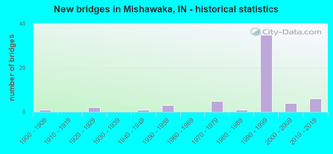
- New bridges - historical statistics
- 11900-1909
- 21920-1929
- 11940-1949
- 31950-1959
- 51970-1979
- 11980-1989
- 351990-1999
- 42000-2009
- 62010-2019

- Reconstructed bridges - Historical Statistics
- 21980-1989
- 31990-1999
- 22000-2009
- 22010-2019


- Bridge Condition - Deck
- 4.0%Excellent
- 4.0%Very good
- 60.0%Good
- 24.0%Satisfactory
- 4.0%Fair
- 4.0%Poor

- Bridge Condition - Superstructure
- 4.0%Excellent
- 4.0%Very good
- 60.0%Good
- 28.0%Satisfactory
- 4.0%Poor

- Bridge Condition - Substructure
- 4.0%Very good
- 72.0%Good
- 20.0%Satisfactory
- 4.0%Fair

- Bridge Condition - Channel
- 55.0%Very good
- 40.0%Good
- 5.0%Satisfactory

- Bridge Condition - Culverts
- 71.4%Very good
- 28.6%Good
Find on map >> Show street view
Structure Number: 7501, Location: 01.76 S SR 930 (Lat: 41.095031, Lng: -85.140281), Route carried "on" structure: US 27, Year Built: 2012, Status: Open, Structure Length: 3.50m (11.48ft), Average Daily Traffic: 23,872 (year 2019), Truck Traffic: 5%, Average Future Daily Traffic: 26,570 (year 2034), Design Load: HL 93, Features Intersected: SPY RUN CREEK
Minimum Vertical Clearance: 30+ m (98+ ft), Kilometerpoint: 0.483, Lanes on structure: 3, Owner: State Highway Agency, Approaching Roadway Width: 12.2m (40.0ft), Skew: 3 degrees, Material/Design: Concrete continuous, Design/Construction: Slab, Number Of Spans In Main Unit: 3, Length of Maximum Span: 13.7m (44.9ft), Curb or Sidewalk Widths: Left: 2.6m (8.5ft), Right: 2.6m (8.5ft), Curb-To-Curb Width: 12.2m (40.0ft), Out-to-Out Width: 18.2m (59.7ft)
Condition: Deck: Good, Superstructure: Good, Substructure: Good, Channel: Very good, Operating Rating: 43.7 metric tons, Method Used To Determine Operating Rating: Load and Resistance Factor Rating (LRFR) rating reported by rating factor(RF) method using HL-93 loadings, Inventory Rating: 33.7 metric tons, Method Used To Determine Inventory Rating: Load and Resistance Factor Rating (LRFR) rating reported by rating factor(RF) method using HL-93 loadings, Structural Evaluation: Better than present minimum criteria, Deck Geometry: Meets minimum limits, Waterway Adequacy: Equal to present desirable criteria, Approach Roadway Alignment: Equal to present desirable criteria, Designated Inspection Frequency: Every 24 months, Inspection Date: March 2022, Deck Structure Type: Concrete Cast-file-Place, Wearing Surface/Protective System: Wearing Surface: Monolithic Concrete, Deck Protection: Epoxy Coated Reinforcing
Find on map >> Show street view
Structure Number: 31507, Location: 00.12 N SR 933 (Lat: 41.664739, Lng: -86.138119), Route carried "on" structure: State highway 331, Year Built: 1986, Year Reconstructed: 2019, Status: Open, Structure Length: 17.50m (57.41ft), Average Daily Traffic: 22,461 (year 2020), Truck Traffic: 5%, Average Future Daily Traffic: 31,873 (year 2038), Design Load: HL 93, Features Intersected: ST JOSEPH RIVER
Minimum Vertical Clearance: 30+ m (98+ ft), Kilometerpoint: 24.382, Lanes on structure: 4, Base Highway Network: Yes (, Subroute: 1), Owner: State Highway Agency, Approaching Roadway Width: 23.2m (76.1ft), Skew: 30 degrees, Material/Design: Prestressed concrete continuous, Design/Construction: Stringer/Multi-beam, Number Of Spans In Main Unit: 6, Length of Maximum Span: 29.1m (95.5ft), Curb or Sidewalk Widths: Left: 2.1m (6.9ft), Right: 0.0m, Curb-To-Curb Width: 20.1m (65.9ft), Out-to-Out Width: 26.4m (86.6ft)
Condition: Deck: Excellent, Superstructure: Excellent, Substructure: Good, Channel: Good, Operating Rating: 65.8 metric tons, Method Used To Determine Operating Rating: Load and Resistance Factor Rating (LRFR) rating reported by rating factor(RF) method using HL-93 loadings, Inventory Rating: 48.9 metric tons, Method Used To Determine Inventory Rating: Load and Resistance Factor Rating (LRFR) rating reported by rating factor(RF) method using HL-93 loadings, Structural Evaluation: Better than present minimum criteria, Deck Geometry: Equal to present minimum criteria, Waterway Adequacy: Equal to present desirable criteria, Approach Roadway Alignment: Equal to present desirable criteria, Designated Inspection Frequency: Every 24 months, Underwater Inspection Frequency: Every 60 months, Inspection Date: August 2021, Underwater Inspection Date: July 2020, Deck Structure Type: Concrete Cast-file-Place, Wearing Surface/Protective System: Wearing Surface: Monolithic Concrete, Deck Protection: Epoxy Coated Reinforcing
Find on map >> Show street view
Structure Number: 31513, Location: 01.02 S I-80 / I-90 (Lat: 41.716450, Lng: -86.139161), Route carried "on" structure: State highway 331, Year Built: 1997, Status: Open, Structure Length: 0.67m (2.20ft), Average Daily Traffic: 14,962 (year 2018), Truck Traffic: 5%, Average Future Daily Traffic: 30,090 (year 2030), Design Load: HS 20+Mod, Features Intersected: JUDAY CREEK
Minimum Vertical Clearance: 30+ m (98+ ft), Kilometerpoint: 30.191, Lanes on structure: 4, Base Highway Network: Yes (, Subroute: 1), Owner: State Highway Agency, Approaching Roadway Width: 23.2m (76.1ft), Skew: 20 degrees, Material/Design: Concrete, Design/Construction: Culvert, Number Of Spans In Main Unit: 1, Length of Maximum Span: 6.1m (20.0ft), Curb-To-Curb Width: 23.2m (76.1ft), Out-to-Out Width: 23.2m (76.1ft)
Condition: Channel: Very good, Culverts: Very good, Operating Rating: 54.5 metric tons, Method Used To Determine Operating Rating: Field evaluation and documented engineering judgment, Inventory Rating: 32.7 metric tons, Method Used To Determine Inventory Rating: Field evaluation and documented engineering judgment, Structural Evaluation: Equal to present desirable criteria, Deck Geometry: Superior to present desirable criteria, Waterway Adequacy: Equal to present desirable criteria, Approach Roadway Alignment: Equal to present desirable criteria, Designated Inspection Frequency: Every 24 months, Inspection Date: April 2021
Find on map >> Show street view
Structure Number: 31517, Location: 00.83 S I-80 / I-90 (Lat: 41.719039, Lng: -86.140350), Route carried "on" structure: State highway 331, Year Built: 1997, Status: Open, Structure Length: 6.89m (22.60ft), Average Daily Traffic: 10,132 (year 2018), Truck Traffic: 5%, Average Future Daily Traffic: 15,045 (year 2030), Design Load: HS 20, Features Intersected: GTW RR
Minimum Vertical Clearance: 30+ m (98+ ft), Kilometerpoint: 30.497, Lanes on structure: 2, Base Highway Network: Yes (, Subroute: 1), Owner: State Highway Agency, Approaching Roadway Width: 11.6m (38.1ft), Skew: 24 degrees, Material/Design: Prestressed concrete continuous, Design/Construction: Stringer/Multi-beam, Number Of Spans In Main Unit: 3, Length of Maximum Span: 23.3m (76.4ft), Curb-To-Curb Width: 12.6m (41.3ft), Out-to-Out Width: 13.5m (44.3ft)
Condition: Deck: Satisfactory, Superstructure: Satisfactory, Substructure: Good, Operating Rating: 54.4 metric tons, Method Used To Determine Operating Rating: Load and Resistance Factor Rating (LRFR) rating reported by rating factor(RF) method using HL-93 loadings, Inventory Rating: 42.1 metric tons, Method Used To Determine Inventory Rating: Load and Resistance Factor Rating (LRFR) rating reported by rating factor(RF) method using HL-93 loadings, Structural Evaluation: Equal to present minimum criteria, Deck Geometry: Better than present minimum criteria, Underclear: Better than present minimum criteria, Approach Roadway Alignment: Equal to present minimum criteria, Designated Inspection Frequency: Every 24 months, Inspection Date: June 2021, Deck Structure Type: Concrete Cast-file-Place, Wearing Surface/Protective System: Wearing Surface: Monolithic Concrete, Deck Protection: Epoxy Coated Reinforcing
Find on map >> Show street view
Structure Number: 4784, Location: 00.45 E SR 23 (Lat: 41.716200, Lng: -86.187697), Route carried "on" structure: City street , Year Built: 1956, Year Reconstructed: 2002, Status: Open, Structure Length: 6.64m (21.78ft), Average Daily Traffic: 12,568 (year 2014), Truck Traffic: 6%, Average Future Daily Traffic: 36,232 (year 2031), Design Load: HS 20, Features Intersected: I-90 EB/WB, Facility Carried by Structure: GRAPE ROAD SB
Minimum Vertical Clearance: 30+ m (98+ ft), Kilometerpoint: 0.000, Lanes on structure: 2, Lanes under structure: 4, Owner: State Toll Authority, Approaching Roadway Width: 8.2m (26.9ft), Material/Design: Steel, Design/Construction: Stringer/Multi-beam, Number Of Spans In Main Unit: 4, Number Of Approach Spans: 2, Length of Maximum Span: 20.0m (65.6ft), Curb or Sidewalk Widths: Left: 0.2m (0.7ft), Right: 0.6m (2.0ft), Curb-To-Curb Width: 7.9m (25.9ft), Out-to-Out Width: 9.1m (29.9ft)
Condition: Deck: Satisfactory, Superstructure: Good, Substructure: Good, Operating Rating: 73.0 metric tons, Method Used To Determine Operating Rating: Load Factor (LF), Inventory Rating: 43.8 metric tons, Method Used To Determine Inventory Rating: Load Factor (LF), Structural Evaluation: Better than present minimum criteria, Deck Geometry: High priority of replacement, Underclear: Somewhat better than minimum adequacy, Approach Roadway Alignment: Equal to present desirable criteria, Designated Inspection Frequency: Every 24 months, Inspection Date: August 2021, Deck Structure Type: Concrete Cast-file-Place, Wearing Surface/Protective System: Wearing Surface: Latex Concrete
Find on map >> Show street view
Structure Number: 47845, Location: 00.46 E SR 23 (Lat: 41.716211, Lng: -86.187553), Route carried "on" structure: Alternate City street , Year Built: 1978, Year Reconstructed: 2002, Status: Open, Structure Length: 5.91m (19.39ft), Average Daily Traffic: 12,568 (year 2014), Truck Traffic: 6%, Average Future Daily Traffic: 36,232 (year 2031), Design Load: HS 20, Features Intersected: I-90 EB/WB, Facility Carried by Structure: GRAPE ROAD NB
Minimum Vertical Clearance: 30+ m (98+ ft), Kilometerpoint: 0.000, Lanes on structure: 2, Lanes under structure: 4, Owner: State Toll Authority, Approaching Roadway Width: 11.6m (38.1ft), Material/Design: Steel continuous, Design/Construction: Stringer/Multi-beam, Number Of Spans In Main Unit: 2, Length of Maximum Span: 29.3m (96.1ft), Curb or Sidewalk Widths: Left: 0.6m (2.0ft), Right: 1.8m (5.9ft), Curb-To-Curb Width: 11.8m (38.7ft), Out-to-Out Width: 15.1m (49.5ft)
Condition: Deck: Good, Superstructure: Good, Substructure: Satisfactory, Inventory Rating: 61.2 metric tons, Method Used To Determine Inventory Rating: Load Factor (LF), Structural Evaluation: Equal to present minimum criteria, Deck Geometry: Better than present minimum criteria, Underclear: Somewhat better than minimum adequacy, Approach Roadway Alignment: Equal to present desirable criteria, Designated Inspection Frequency: Every 24 months, Inspection Date: August 2021, Deck Structure Type: Concrete Cast-file-Place, Wearing Surface/Protective System: Wearing Surface: Latex Concrete
Find on map >> Show street view
Structure Number: 47847, Location: 00.94 E SR 23 (Lat: 41.716361, Lng: -86.178025), Route carried "on" structure: City street , Year Built: 1993, Status: Open, Structure Length: 7.13m (23.39ft), Average Daily Traffic: 26,066 (year 2014), Truck Traffic: 5%, Average Future Daily Traffic: 29,040 (year 2031), Design Load: HS 20, Features Intersected: I-90 EB/WB, Facility Carried by Structure: MAIN STREET
Minimum Vertical Clearance: 30+ m (98+ ft), Kilometerpoint: 0.000, Lanes on structure: 4, Lanes under structure: 4, Owner: County Highway Agency, Approaching Roadway Width: 18.0m (59.1ft), Material/Design: Steel continuous, Design/Construction: Stringer/Multi-beam, Number Of Spans In Main Unit: 2, Length of Maximum Span: 36.0m (118.1ft), Curb or Sidewalk Widths: Left: 0.2m (0.7ft), Right: 0.0m, Curb-To-Curb Width: 18.0m (59.1ft), Out-to-Out Width: 20.7m (67.9ft)
Condition: Deck: Very good, Superstructure: Satisfactory, Substructure: Satisfactory, Operating Rating: 59.9 metric tons, Method Used To Determine Operating Rating: Load Factor (LF), Inventory Rating: 35.9 metric tons, Method Used To Determine Inventory Rating: Load Factor (LF), Structural Evaluation: Equal to present minimum criteria, Deck Geometry: Somewhat better than minimum adequacy, Underclear: Equal to present minimum criteria, Approach Roadway Alignment: Equal to present desirable criteria, Designated Inspection Frequency: Every 24 months, Inspection Date: August 2021, Deck Structure Type: Concrete Cast-file-Place, Wearing Surface/Protective System: Wearing Surface: Integral Concrete, Deck Protection: Epoxy Coated Reinforcing
Find on map >> Show street view
Structure Number: 47867, Location: 03.24 E SR 23 (Lat: 41.730400, Lng: -86.144553), Route carried "on" structure: State highway 331, Year Built: 1993, Status: Open, Structure Length: 8.50m (27.89ft), Average Daily Traffic: 6,403 (year 2014), Truck Traffic: 9%, Average Future Daily Traffic: 26,852 (year 2031), Design Load: HS 20, Features Intersected: I-90 EB/WB, RAMP
Minimum Vertical Clearance: 30+ m (98+ ft), Kilometerpoint: 31.833, Lanes on structure: 2, Lanes under structure: 5, Base Highway Network: Yes (, Subroute: 1), Owner: State Toll Authority, Approaching Roadway Width: 11.6m (38.1ft), Material/Design: Steel continuous, Design/Construction: Stringer/Multi-beam, Number Of Spans In Main Unit: 2, Length of Maximum Span: 42.7m (140.1ft), Curb-To-Curb Width: 11.6m (38.1ft), Out-to-Out Width: 12.6m (41.3ft)
Condition: Deck: Good, Superstructure: Satisfactory, Substructure: Good, Operating Rating: 67.1 metric tons, Method Used To Determine Operating Rating: Load Factor (LF), Inventory Rating: 40.2 metric tons, Method Used To Determine Inventory Rating: Load Factor (LF), Structural Evaluation: Equal to present minimum criteria, Deck Geometry: Equal to present minimum criteria, Underclear: Somewhat better than minimum adequacy, Approach Roadway Alignment: Equal to present desirable criteria, Designated Inspection Frequency: Every 24 months, Inspection Date: August 2021, Deck Structure Type: Concrete Cast-file-Place, Wearing Surface/Protective System: Wearing Surface: Monolithic Concrete, Deck Protection: Epoxy Coated Reinforcing
Find on map >> Show street view
Structure Number: 47868, Location: 03.24 E SR 23 (Lat: 41.730261, Lng: -86.144722), Route carried "on" structure: State highway 331, Year Built: 1993, Status: Open, Structure Length: 8.50m (27.89ft), Average Daily Traffic: 6,403 (year 2015), Truck Traffic: 6%, Average Future Daily Traffic: 26,852 (year 2031), Design Load: HS 20, Features Intersected: I-90 EB/WB, RAMP
Minimum Vertical Clearance: 30+ m (98+ ft), Kilometerpoint: 31.833, Lanes on structure: 2, Lanes under structure: 5, Base Highway Network: Yes (, Subroute: 1), Owner: State Toll Authority, Approaching Roadway Width: 11.6m (38.1ft), Material/Design: Steel continuous, Design/Construction: Stringer/Multi-beam, Number Of Spans In Main Unit: 2, Length of Maximum Span: 42.7m (140.1ft), Curb-To-Curb Width: 11.6m (38.1ft), Out-to-Out Width: 12.6m (41.3ft)
Condition: Deck: Good, Superstructure: Satisfactory, Substructure: Good, Operating Rating: 67.1 metric tons, Method Used To Determine Operating Rating: Load Factor (LF), Inventory Rating: 40.2 metric tons, Method Used To Determine Inventory Rating: Load Factor (LF), Structural Evaluation: Equal to present minimum criteria, Deck Geometry: Equal to present minimum criteria, Underclear: Better than present minimum criteria, Approach Roadway Alignment: Equal to present desirable criteria, Designated Inspection Frequency: Every 24 months, Inspection Date: August 2021, Deck Structure Type: Concrete Cast-file-Place, Wearing Surface/Protective System: Wearing Surface: Monolithic Concrete, Deck Protection: Epoxy Coated Reinforcing
Find on map >> Show street view
Structure Number: 7501, Location: 02.81 S SR 933 (Lat: 41.624461, Lng: -86.176781), Route carried "on" structure: State highway 331, Year Built: 1991, Year Reconstructed: 2019, Status: Open, Structure Length: 6.34m (20.80ft), Average Daily Traffic: 8,230 (year 2018), Truck Traffic: 8%, Average Future Daily Traffic: 23,935 (year 2038), Design Load: HS 20+Mod, Features Intersected: US 20 EB/WB
Minimum Vertical Clearance: 30+ m (98+ ft), Kilometerpoint: 16.351, Lanes on structure: 5, Lanes under structure: 4, Owner: State Highway Agency, Approaching Roadway Width: 25.6m (84.0ft), Skew: 20 degrees, Material/Design: Steel continuous, Design/Construction: Stringer/Multi-beam, Number Of Spans In Main Unit: 2, Length of Maximum Span: 31.2m (102.4ft), Curb-To-Curb Width: 25.6m (84.0ft), Out-to-Out Width: 27.7m (90.9ft)
Condition: Deck: Good, Superstructure: Good, Substructure: Good, Operating Rating: 57.7 metric tons, Method Used To Determine Operating Rating: Load and Resistance Factor Rating (LRFR) rating reported by rating factor(RF) method using HL-93 loadings, Inventory Rating: 44.4 metric tons, Method Used To Determine Inventory Rating: Load and Resistance Factor Rating (LRFR) rating reported by rating factor(RF) method using HL-93 loadings, Structural Evaluation: Better than present minimum criteria, Deck Geometry: Superior to present desirable criteria, Underclear: Somewhat better than minimum adequacy, Approach Roadway Alignment: Equal to present desirable criteria, Designated Inspection Frequency: Every 24 months, Inspection Date: June 2021, Deck Structure Type: Concrete Cast-file-Place, Wearing Surface/Protective System: Wearing Surface: Latex Concrete, Deck Protection: Epoxy Coated Reinforcing
Find on map >> Show street view
Structure Number: 7503, Location: 06.12 E US 31 (Lat: 41.624200, Lng: -86.138169), Route carried "on" structure: US 20, Year Built: 1991, Year Reconstructed: 2021, Status: Open, Structure Length: 5.88m (19.29ft), Average Daily Traffic: 19,170 (year 2018), Truck Traffic: 18%, Average Future Daily Traffic: 20,000 (year 2030), Design Load: HS 20, Features Intersected: SR 331 (ELM/CAPITAL) NB/
Minimum Vertical Clearance: 30+ m (98+ ft), Kilometerpoint: 39.268, Lanes on structure: 3, Lanes under structure: 5, Base Highway Network: Yes (, Subroute: 1), Owner: State Highway Agency, Approaching Roadway Width: 14.0m (45.9ft), Material/Design: Steel continuous, Design/Construction: Stringer/Multi-beam, Number Of Spans In Main Unit: 2, Length of Maximum Span: 28.8m (94.5ft), Curb-To-Curb Width: 18.6m (61.0ft), Out-to-Out Width: 19.4m (63.6ft)
Condition: Deck: Fair, Superstructure: Satisfactory, Substructure: Very good, Operating Rating: 49.6 metric tons, Method Used To Determine Operating Rating: Load and Resistance Factor Rating (LRFR) rating reported by rating factor(RF) method using HL-93 loadings, Inventory Rating: 38.2 metric tons, Method Used To Determine Inventory Rating: Load and Resistance Factor Rating (LRFR) rating reported by rating factor(RF) method using HL-93 loadings, Structural Evaluation: Equal to present minimum criteria, Deck Geometry: Superior to present desirable criteria, Underclear: Meets minimum limits, Approach Roadway Alignment: Equal to present desirable criteria, Designated Inspection Frequency: Every 24 months, Inspection Date: November 2021, Deck Structure Type: Concrete Cast-file-Place, Wearing Surface/Protective System: Wearing Surface: Latex Concrete, Deck Protection: Epoxy Coated Reinforcing
Find on map >> Show street view
Structure Number: 7504, Location: 06.12 E US 31 (Lat: 41.624369, Lng: -86.138169), Route carried "on" structure: US 20, Year Built: 1991, Year Reconstructed: 2021, Status: Open, Structure Length: 5.88m (19.29ft), Average Daily Traffic: 19,540 (year 2018), Truck Traffic: 12%, Average Future Daily Traffic: 20,000 (year 2030), Design Load: HS 20, Features Intersected: SR 331 (ELM/CAPITAL) NB/
Minimum Vertical Clearance: 30+ m (98+ ft), Kilometerpoint: 39.268, Lanes on structure: 2, Lanes under structure: 5, Base Highway Network: Yes (, Subroute: 1), Owner: State Highway Agency, Approaching Roadway Width: 14.6m (47.9ft), Material/Design: Steel continuous, Design/Construction: Stringer/Multi-beam, Number Of Spans In Main Unit: 2, Length of Maximum Span: 28.8m (94.5ft), Curb-To-Curb Width: 14.0m (45.9ft), Out-to-Out Width: 14.8m (48.6ft)
Condition: Deck: Good, Superstructure: Very good, Substructure: Satisfactory, Operating Rating: 44.1 metric tons, Method Used To Determine Operating Rating: Load and Resistance Factor Rating (LRFR) rating reported by rating factor(RF) method using HL-93 loadings, Inventory Rating: 33.7 metric tons, Method Used To Determine Inventory Rating: Load and Resistance Factor Rating (LRFR) rating reported by rating factor(RF) method using HL-93 loadings, Structural Evaluation: Equal to present minimum criteria, Deck Geometry: Superior to present desirable criteria, Underclear: Meets minimum limits, Approach Roadway Alignment: Equal to present desirable criteria, Designated Inspection Frequency: Every 24 months, Inspection Date: November 2021, Deck Structure Type: Concrete Cast-file-Place, Wearing Surface/Protective System: Wearing Surface: Latex Concrete, Deck Protection: Epoxy Coated Reinforcing
Find on map >> Show street view
Structure Number: 7505, Location: 06.12 E US 31 (Lat: 41.624500, Lng: -86.138169), Route carried "on" structure: Ramp US 20, Year Built: 1991, Status: Open, Structure Length: 5.88m (19.29ft), Average Daily Traffic: 602 (year 2018), Truck Traffic: 8%, Average Future Daily Traffic: 2,151 (year 2030), Design Load: HS 20, Features Intersected: SR 331 (ELM/CAPITAL) NB/
Minimum Vertical Clearance: 30+ m (98+ ft), Kilometerpoint: 39.268, Lanes on structure: 1, Lanes under structure: 5, Base Highway Network: Yes (, Subroute: 1), Owner: State Highway Agency, Approaching Roadway Width: 9.8m (32.2ft), Material/Design: Steel continuous, Design/Construction: Stringer/Multi-beam, Number Of Spans In Main Unit: 2, Length of Maximum Span: 28.8m (94.5ft), Curb-To-Curb Width: 9.9m (32.5ft), Out-to-Out Width: 10.8m (35.4ft)
Condition: Deck: Good, Superstructure: Good, Substructure: Good, Operating Rating: 40.8 metric tons, Method Used To Determine Operating Rating: Load and Resistance Factor Rating (LRFR) rating reported by rating factor(RF) method using HL-93 loadings, Inventory Rating: 31.4 metric tons, Method Used To Determine Inventory Rating: Load and Resistance Factor Rating (LRFR) rating reported by rating factor(RF) method using HL-93 loadings, Structural Evaluation: Better than present minimum criteria, Deck Geometry: Superior to present desirable criteria, Underclear: High priority of corrective action, Approach Roadway Alignment: Equal to present desirable criteria, Designated Inspection Frequency: Every 24 months, Inspection Date: July 2020, Deck Structure Type: Concrete Cast-file-Place, Wearing Surface/Protective System: Wearing Surface: Latex Concrete, Deck Protection: Epoxy Coated Reinforcing
Find on map >> Show street view
Structure Number: 7506, Location: 02.98 E SR 331 (Lat: 41.624389, Lng: -86.119289), Route carried "on" structure: County highway , Year Built: 1990, Status: Open, Structure Length: 6.77m (22.21ft), Average Daily Traffic: 1,297 (year 2018), Truck Traffic: 7%, Average Future Daily Traffic: 2,086 (year 2030), Design Load: HS 20, Features Intersected: US 20 EB/WB, Facility Carried by Structure: DOGWOOD ROAD
Minimum Vertical Clearance: 30+ m (98+ ft), Kilometerpoint: 135.169, Lanes on structure: 2, Lanes under structure: 4, Owner: State Highway Agency, Approaching Roadway Width: 11.0m (36.1ft), Material/Design: Steel continuous, Design/Construction: Stringer/Multi-beam, Number Of Spans In Main Unit: 2, Length of Maximum Span: 33.2m (108.9ft), Curb-To-Curb Width: 11.4m (37.4ft), Out-to-Out Width: 12.3m (40.4ft)
Condition: Deck: Good, Superstructure: Good, Substructure: Satisfactory, Operating Rating: 52.8 metric tons, Method Used To Determine Operating Rating: Load and Resistance Factor Rating (LRFR) rating reported by rating factor(RF) method using HL-93 loadings, Inventory Rating: 40.8 metric tons, Method Used To Determine Inventory Rating: Load and Resistance Factor Rating (LRFR) rating reported by rating factor(RF) method using HL-93 loadings, Structural Evaluation: Equal to present minimum criteria, Deck Geometry: Equal to present minimum criteria, Underclear: Somewhat better than minimum adequacy, Approach Roadway Alignment: Equal to present desirable criteria, Designated Inspection Frequency: Every 24 months, Inspection Date: July 2020, Deck Structure Type: Concrete Cast-file-Place, Wearing Surface/Protective System: Wearing Surface: Monolithic Concrete, Deck Protection: Epoxy Coated Reinforcing
Find on map >> Show street view
Structure Number: 80036, Location: 03.59 N US 20 (Lat: 41.672111, Lng: -86.138300), Route carried "on" structure: State highway 331, Year Built: 2006, Status: Open, Structure Length: 0.80m (2.62ft), Average Daily Traffic: 21,283 (year 2015), Truck Traffic: 8%, Average Future Daily Traffic: 44,000 (year 2030), Design Load: HS 20, Features Intersected: WILLOW CREEK
Minimum Vertical Clearance: 30+ m (98+ ft), Kilometerpoint: 25.669, Lanes on structure: 5, Base Highway Network: Yes (, Subroute: 1), Owner: State Highway Agency, Approaching Roadway Width: 31.7m (104.0ft), Skew: 24 degrees, Material/Design: Concrete, Design/Construction: Culvert, Number Of Spans In Main Unit: 1, Length of Maximum Span: 7.2m (23.6ft), Curb or Sidewalk Widths: Left: 1.5m (4.9ft), Right: 1.5m (4.9ft), Curb-To-Curb Width: 31.7m (104.0ft), Out-to-Out Width: 50.3m (165.0ft)
Condition: Channel: Good, Culverts: Very good, Operating Rating: 67.7 metric tons, Method Used To Determine Operating Rating: Load and Resistance Factor Rating (LRFR) rating reported by rating factor(RF) method using HL-93 loadings, Inventory Rating: 52.5 metric tons, Method Used To Determine Inventory Rating: Load and Resistance Factor Rating (LRFR) rating reported by rating factor(RF) method using HL-93 loadings, Structural Evaluation: Equal to present desirable criteria, Deck Geometry: Superior to present desirable criteria, Waterway Adequacy: Equal to present desirable criteria, Approach Roadway Alignment: Equal to present desirable criteria, Designated Inspection Frequency: Every 24 months, Inspection Date: September 2020
Find on map >> Show street view
Structure Number: 7100011, Location: 00.10 N of SR 933 (Lat: 41.662219, Lng: -86.173519), Route carried "on" structure: City street , Year Built: 1990, Status: Open, Structure Length: 12.86m (42.19ft), Average Daily Traffic: 6,046 (year 2019), Truck Traffic: 9%, Average Future Daily Traffic: 7,378 (year 2039), Design Load: HS 20, Features Intersected: ST. JOSEPH River, Facility Carried by Structure: CEDAR St
Minimum Vertical Clearance: 30+ m (98+ ft), Kilometerpoint: 0.000, Lanes on structure: 2, Owner: County Highway Agency, Approaching Roadway Width: 8.2m (26.9ft), Navigation Control: Yes ( Vertical Clearance: 3.0m (9.8ft), Horizontal Clearance: 45.7m (149.9ft)), Material/Design: Steel continuous, Design/Construction: Stringer/Multi-beam, Number Of Spans In Main Unit: 3, Length of Maximum Span: 46.6m (152.9ft), Curb or Sidewalk Widths: Left: 1.8m (5.9ft), Right: 2.1m (6.9ft), Curb-To-Curb Width: 8.2m (26.9ft), Out-to-Out Width: 13.4m (44.0ft)
Condition: Deck: Satisfactory, Superstructure: Good, Substructure: Good, Channel: Very good, Operating Rating: 54.6 metric tons, Method Used To Determine Operating Rating: Load Factor (LF), Inventory Rating: 32.7 metric tons, Method Used To Determine Inventory Rating: Load Factor (LF), Structural Evaluation: Better than present minimum criteria, Deck Geometry: High priority of corrective action, Waterway Adequacy: Superior to present desirable criteria, Approach Roadway Alignment: Equal to present desirable criteria, Length Of Structure Improvement: 12.86m (42.19ft), Designated Inspection Frequency: Every 24 months, Underwater Inspection Frequency: Every 60 months, Inspection Date: September 2020, Underwater Inspection Date: August 2020, Bridge Improvement Cost: $148,000, Roadway Improvement Cost: $15,000, Total Project Cost: $222,000 ( Estimate for 2020), Deck Structure Type: Concrete Cast-file-Place, Wearing Surface/Protective System: Wearing Surface: Monolithic Concrete, Deck Protection: Epoxy Coated Reinforcing
Find on map >> Show street view
Structure Number: 7100012, Location: 00.60 N of ROOSEVELT Rd (Lat: 41.602289, Lng: -86.099781), Route carried "on" structure: Alternate County highway , Year Built: 1990, Status: Open, Structure Length: 0.79m (2.59ft), Average Daily Traffic: 89 (year 2018), Truck Traffic: 13%, Average Future Daily Traffic: 109 (year 2038), Design Load: HS 20, Features Intersected: ROGERS Ditch, Facility Carried by Structure: CEDAR Rd
Minimum Vertical Clearance: 30+ m (98+ ft), Kilometerpoint: 0.000, Lanes on structure: 2, Owner: County Highway Agency, Approaching Roadway Width: 6.4m (21.0ft), Material/Design: Wood or Timber, Design/Construction: Slab, Number Of Spans In Main Unit: 1, Length of Maximum Span: 7.3m (24.0ft), Curb-To-Curb Width: 7.3m (24.0ft), Out-to-Out Width: 7.7m (25.3ft)
Condition: Deck: Satisfactory, Superstructure: Satisfactory, Substructure: Good, Channel: Good, Operating Rating: 57.6 metric tons, Method Used To Determine Operating Rating: Allowable Stress (AS), Inventory Rating: 41.0 metric tons, Method Used To Determine Inventory Rating: Allowable Stress (AS), Structural Evaluation: Equal to present minimum criteria, Deck Geometry: Equal to present minimum criteria, Waterway Adequacy: Meets minimum limits, Approach Roadway Alignment: Equal to present desirable criteria, Length Of Structure Improvement: 0.79m (2.59ft), Designated Inspection Frequency: Every 24 months, Inspection Date: September 2020, Bridge Improvement Cost: $4,000, Roadway Improvement Cost: $7,000, Total Project Cost: $12,000 ( Estimate for 2020), Deck Structure Type: Wood or Timber, Wearing Surface/Protective System: Wearing Surface: Bituminous
Find on map >> Show street view
Structure Number: 7100022, Location: 00.20 E of CEDAR Rd (Lat: 41.625469, Lng: -86.094639), Route carried "on" structure: Alternate County highway , Year Built: 1945, Year Reconstructed: 1987, Status: Open, Structure Length: 0.61m (2.00ft), Average Daily Traffic: 2,013 (year 2019), Truck Traffic: 5%, Average Future Daily Traffic: 2,992 (year 2039), Design Load: HS 20, Features Intersected: ELLER Ditch, Facility Carried by Structure: DRAGOON Trail
Minimum Vertical Clearance: 30+ m (98+ ft), Kilometerpoint: 0.000, Lanes on structure: 2, Owner: County Highway Agency, Approaching Roadway Width: 7.0m (23.0ft), Material/Design: Steel, Design/Construction: Culvert, Number Of Spans In Main Unit: 1, Length of Maximum Span: 6.1m (20.0ft)
Condition: Channel: Good, Culverts: Good, Operating Rating: 39.8 metric tons, Method Used To Determine Operating Rating: Load and Resistance Factor (LRFR), Inventory Rating: 32.7 metric tons, Method Used To Determine Inventory Rating: Load and Resistance Factor (LRFR), Structural Evaluation: Better than present minimum criteria, Waterway Adequacy: Superior to present desirable criteria, Approach Roadway Alignment: Equal to present desirable criteria, Designated Inspection Frequency: Every 24 months, Inspection Date: September 2020
Find on map >> Show street view
Structure Number: 7100026, Location: 00.10 S of MADISON Rd (Lat: 41.578469, Lng: -86.137889), Route carried "on" structure: County highway , Year Built: 1979, Status: Open, Structure Length: 1.40m (4.59ft), Average Daily Traffic: 1,207 (year 2021), Truck Traffic: 11%, Average Future Daily Traffic: 1,473 (year 2041), Design Load: HS 20, Features Intersected: GRIMES Ditch, Facility Carried by Structure: ELM Rd
Minimum Vertical Clearance: 30+ m (98+ ft), Kilometerpoint: 0.000, Lanes on structure: 2, Owner: County Highway Agency, Approaching Roadway Width: 6.4m (21.0ft), Skew: 3 degrees, Material/Design: Prestressed concrete, Design/Construction: Box Beam or Girders - Multiple, Number Of Spans In Main Unit: 1, Length of Maximum Span: 11.9m (39.0ft), Curb-To-Curb Width: 8.1m (26.6ft), Out-to-Out Width: 8.5m (27.9ft)
Condition: Deck: Poor, Superstructure: Poor, Substructure: Fair, Channel: Satisfactory, Operating Rating: 50.2 metric tons, Method Used To Determine Operating Rating: Load Factor (LF), Inventory Rating: 30.0 metric tons, Method Used To Determine Inventory Rating: Load Factor (LF), Structural Evaluation: Meets minimum limits, Deck Geometry: Meets minimum limits, Waterway Adequacy: Better than present minimum criteria, Approach Roadway Alignment: Equal to present desirable criteria, Length Of Structure Improvement: 2.13m (6.99ft), Designated Inspection Frequency: Every 12 months, Inspection Date: September 2021, Bridge Improvement Cost: $549,000, Roadway Improvement Cost: $55,000, Total Project Cost: $824,000 ( Estimate for 2020), Deck Structure Type: Concrete Precast Panels, Wearing Surface/Protective System: Wearing Surface: Bituminous
Find on map >> Show street view
Structure Number: 7100051, Location: 00.10 N of SR 933 (Lat: 41.660561, Lng: -86.196439), Route carried "on" structure: City street , Year Built: 1925, Year Reconstructed: 2006, Status: Open, Structure Length: 14.14m (46.39ft), Average Daily Traffic: 11,247 (year 2019), Truck Traffic: 2%, Average Future Daily Traffic: 13,723 (year 2039), Design Load: HS 20, Features Intersected: ST JOSEPH RIVER, Facility Carried by Structure: LOGAN St
Minimum Vertical Clearance: 30+ m (98+ ft), Kilometerpoint: 0.000, Lanes on structure: 3, Owner: County Highway Agency, Approaching Roadway Width: 13.4m (44.0ft), Skew: 4 degrees, Navigation Control: Yes ( Vertical Clearance: 4.6m (15.1ft), Horizontal Clearance: 30.5m (100.1ft)), Material/Design: Concrete, Design/Construction: Arch - Deck, Number Of Spans In Main Unit: 4, Length of Maximum Span: 30.5m (100.1ft), Curb or Sidewalk Widths: Left: 1.5m (4.9ft), Right: 3.0m (9.8ft), Curb-To-Curb Width: 13.4m (44.0ft), Out-to-Out Width: 19.1m (62.7ft)
Condition: Deck: Satisfactory, Superstructure: Good, Substructure: Good, Channel: Good, Operating Rating: 32.7 metric tons, Method Used To Determine Operating Rating: Field evaluation and documented engineering judgment, Inventory Rating: 32.7 metric tons, Method Used To Determine Inventory Rating: Field evaluation and documented engineering judgment, Structural Evaluation: Better than present minimum criteria, Deck Geometry: Somewhat better than minimum adequacy, Waterway Adequacy: Superior to present desirable criteria, Approach Roadway Alignment: Equal to present desirable criteria, Designated Inspection Frequency: Every 24 months, Underwater Inspection Frequency: Every 60 months, Inspection Date: September 2020, Underwater Inspection Date: August 2020, Deck Structure Type: Concrete Cast-file-Place, Wearing Surface/Protective System: Wearing Surface: Monolithic Concrete, Deck Protection: Epoxy Coated Reinforcing
Find on map >> Show street view
Structure Number: 7100052, Location: 00.30 E of CEDAR St (Lat: 41.666361, Lng: -86.167500), Route carried "on" structure: City street , Year Built: 1924, Year Reconstructed: 2011, Status: Open, Structure Length: 11.86m (38.91ft), Average Daily Traffic: 7,463 (year 2019), Truck Traffic: 5%, Average Future Daily Traffic: 9,107 (year 2039), Design Load: HS 20, Features Intersected: ST JOSEPH RIVER, Facility Carried by Structure: MISHAWAKA Ave
Minimum Vertical Clearance: 30+ m (98+ ft), Kilometerpoint: 0.000, Lanes on structure: 2, Owner: County Highway Agency, Approaching Roadway Width: 9.1m (29.9ft), Navigation Control: Yes ( Vertical Clearance: 5.5m (18.0ft), Horizontal Clearance: 29.3m (96.1ft)), Material/Design: Concrete, Design/Construction: Arch - Deck, Number Of Spans In Main Unit: 4, Length of Maximum Span: 29.3m (96.1ft), Curb or Sidewalk Widths: Left: 1.8m (5.9ft), Right: 3.0m (9.8ft), Curb-To-Curb Width: 9.1m (29.9ft), Out-to-Out Width: 15.0m (49.2ft)
Condition: Deck: Good, Superstructure: Good, Substructure: Good, Channel: Very good, Operating Rating: 32.7 metric tons, Method Used To Determine Operating Rating: Field evaluation and documented engineering judgment, Inventory Rating: 32.7 metric tons, Method Used To Determine Inventory Rating: Field evaluation and documented engineering judgment, Structural Evaluation: Better than present minimum criteria, Deck Geometry: Meets minimum limits, Waterway Adequacy: Superior to present desirable criteria, Approach Roadway Alignment: Equal to present desirable criteria, Designated Inspection Frequency: Every 24 months, Underwater Inspection Frequency: Every 60 months, Inspection Date: September 2020, Underwater Inspection Date: August 2020, Deck Structure Type: Concrete Cast-file-Place, Wearing Surface/Protective System: Wearing Surface: Monolithic Concrete, Deck Protection: Epoxy Coated Reinforcing
Find on map >> Show street view
Structure Number: 7100107, Location: 00.40 N of DAY Rd (Lat: 41.703781, Lng: -86.172269), Route carried "on" structure: Alternate County highway , Year Built: 1970, Year Reconstructed: 1985, Status: Open, Structure Length: 0.79m (2.59ft), Average Daily Traffic: 206 (year 2015), Truck Traffic: 5%, Average Future Daily Traffic: 251 (year 2035), Design Load: HS 20, Features Intersected: JUDAY Creek, Facility Carried by Structure: WINDING BROOK Dr
Minimum Vertical Clearance: 30+ m (98+ ft), Kilometerpoint: 0.000, Lanes on structure: 2, Owner: County Highway Agency, Approaching Roadway Width: 6.6m (21.7ft), Skew: 1 degrees, Material/Design: Prestressed concrete, Design/Construction: Box Beam or Girders - Multiple, Number Of Spans In Main Unit: 1, Length of Maximum Span: 7.5m (24.6ft), Curb or Sidewalk Widths: Left: 0.2m (0.7ft), Right: 1.4m (4.6ft), Curb-To-Curb Width: 7.1m (23.3ft), Out-to-Out Width: 9.6m (31.5ft)
Condition: Deck: Good, Superstructure: Good, Substructure: Good, Channel: Good, Operating Rating: 63.7 metric tons, Method Used To Determine Operating Rating: Load Factor (LF), Inventory Rating: 38.8 metric tons, Method Used To Determine Inventory Rating: Load Factor (LF), Structural Evaluation: Better than present minimum criteria, Deck Geometry: Meets minimum limits, Waterway Adequacy: Better than present minimum criteria, Approach Roadway Alignment: Equal to present desirable criteria, Designated Inspection Frequency: Every 24 months, Inspection Date: September 2020, Deck Structure Type: Concrete Precast Panels, Wearing Surface/Protective System: Wearing Surface: Bituminous
Find on map >> Show street view
Structure Number: 7100115, Location: 00.30 E of MAIN St (Lat: 41.702719, Lng: -86.178439), Route carried "on" structure: City street , Year Built: 1990, Status: Open, Structure Length: 3.25m (10.66ft), Average Daily Traffic: 2,846 (year 2019), Truck Traffic: 1%, Average Future Daily Traffic: 4,277 (year 2039), Design Load: HS 20, Features Intersected: JUDAY Creek, Facility Carried by Structure: SB EDISON LK Pkwy
Minimum Vertical Clearance: 30+ m (98+ ft), Kilometerpoint: 0.000, Lanes on structure: 2, Owner: County Highway Agency, Approaching Roadway Width: 8.2m (26.9ft), Skew: 3 degrees, Material/Design: Concrete continuous, Design/Construction: Slab, Number Of Spans In Main Unit: 3, Length of Maximum Span: 10.5m (34.4ft), Curb-To-Curb Width: 8.1m (26.6ft), Out-to-Out Width: 9.0m (29.5ft)
Condition: Deck: Good, Superstructure: Good, Substructure: Good, Channel: Very good, Operating Rating: 68.8 metric tons, Method Used To Determine Operating Rating: Load Factor (LF), Inventory Rating: 41.2 metric tons, Method Used To Determine Inventory Rating: Load Factor (LF), Structural Evaluation: Better than present minimum criteria, Deck Geometry: High priority of replacement, Waterway Adequacy: Equal to present desirable criteria, Approach Roadway Alignment: Equal to present desirable criteria, Length Of Structure Improvement: 3.26m (10.70ft), Designated Inspection Frequency: Every 24 months, Inspection Date: September 2020, Bridge Improvement Cost: $88,000, Roadway Improvement Cost: $9,000, Total Project Cost: $132,000 ( Estimate for 2020), Deck Structure Type: Concrete Cast-file-Place, Wearing Surface/Protective System: Wearing Surface: Monolithic Concrete
Find on map >> Show street view
Structure Number: 7100116, Location: 00.50 S of DOUGLAS Rd (Lat: 41.702061, Lng: -86.182611), Route carried "on" structure: City street , Year Built: 1991, Status: Open, Structure Length: 2.58m (8.46ft), Average Daily Traffic: 22,363 (year 2020), Truck Traffic: 1%, Average Future Daily Traffic: 27,287 (year 2040), Design Load: HS 20, Features Intersected: JUDAY Creek, Facility Carried by Structure: MISHAWAKA:MAIN St
Minimum Vertical Clearance: 30+ m (98+ ft), Kilometerpoint: 0.000, Lanes on structure: 4, Owner: County Highway Agency, Approaching Roadway Width: 18.0m (59.1ft), Skew: 21 degrees, Material/Design: Concrete continuous, Design/Construction: Slab, Number Of Spans In Main Unit: 3, Length of Maximum Span: 9.1m (29.9ft), Curb or Sidewalk Widths: Left: 0.0m, Right: 1.7m (5.6ft), Curb-To-Curb Width: 18.0m (59.1ft), Out-to-Out Width: 20.7m (67.9ft)
Condition: Deck: Good, Superstructure: Good, Substructure: Good, Channel: Very good, Operating Rating: 62.0 metric tons, Method Used To Determine Operating Rating: Load Factor (LF), Inventory Rating: 37.2 metric tons, Method Used To Determine Inventory Rating: Load Factor (LF), Structural Evaluation: Better than present minimum criteria, Deck Geometry: Somewhat better than minimum adequacy, Waterway Adequacy: Equal to present desirable criteria, Approach Roadway Alignment: Equal to present desirable criteria, Length Of Structure Improvement: 2.59m (8.50ft), Designated Inspection Frequency: Every 24 months, Inspection Date: September 2020, Bridge Improvement Cost: $90,000, Roadway Improvement Cost: $9,000, Total Project Cost: $135,000 ( Estimate for 2020), Deck Structure Type: Concrete Cast-file-Place, Wearing Surface/Protective System: Wearing Surface: Monolithic Concrete
Find on map >> Show street view
Structure Number: 7100122, Location: 00.30 N SR 933 (Lat: 41.665281, Lng: -86.181269), Route carried "on" structure: City street , Year Built: 1907, Year Reconstructed: 1995, Status: Open, Structure Length: 9.90m (32.48ft), Average Daily Traffic: 24,491 (year 2019), Truck Traffic: 2%, Average Future Daily Traffic: 29,884 (year 2039), Design Load: HS 20, Features Intersected: ST JOSEPH RIVER, Facility Carried by Structure: MAIN STREET
Minimum Vertical Clearance: 30+ m (98+ ft), Kilometerpoint: 0.000, Lanes on structure: 5, Owner: County Highway Agency, Approaching Roadway Width: 18.9m (62.0ft), Navigation Control: Yes ( Vertical Clearance: 4.6m (15.1ft), Horizontal Clearance: 24.4m (80.1ft)), Material/Design: Prestressed concrete continuous, Design/Construction: Stringer/Multi-beam, Number Of Spans In Main Unit: 3, Length of Maximum Span: 36.0m (118.1ft), Curb or Sidewalk Widths: Left: 1.8m (5.9ft), Right: 1.8m (5.9ft), Curb-To-Curb Width: 18.9m (62.0ft), Out-to-Out Width: 23.3m (76.4ft)
Condition: Deck: Good, Superstructure: Good, Substructure: Satisfactory, Channel: Very good, Operating Rating: 66.1 metric tons, Method Used To Determine Operating Rating: Load Factor (LF), Inventory Rating: 32.2 metric tons, Method Used To Determine Inventory Rating: Load Factor (LF), Structural Evaluation: Equal to present minimum criteria, Deck Geometry: Meets minimum limits, Waterway Adequacy: Superior to present desirable criteria, Approach Roadway Alignment: Equal to present desirable criteria, Length Of Structure Improvement: 9.91m (32.51ft), Designated Inspection Frequency: Every 24 months, Underwater Inspection Frequency: Every 60 months, Inspection Date: September 2020, Underwater Inspection Date: September 2017, Bridge Improvement Cost: $94,000, Roadway Improvement Cost: $53,000, Total Project Cost: $194,000 ( Estimate for 2020), Deck Structure Type: Concrete Cast-file-Place, Wearing Surface/Protective System: Wearing Surface: Monolithic Concrete
Find on map >> Show street view
Structure Number: 7100123, Location: 00.20 N SR 933 (Lat: 41.664250, Lng: -86.181300), Route carried "on" structure: City street , Year Built: 1994, Status: Open, Structure Length: 0.61m (2.00ft), Average Daily Traffic: 24,491 (year 2019), Truck Traffic: 2%, Average Future Daily Traffic: 29,884 (year 2039), Design Load: HS 20, Features Intersected: MILL RACEWAY, Facility Carried by Structure: MAIN STREET
Minimum Vertical Clearance: 30+ m (98+ ft), Kilometerpoint: 0.000, Lanes on structure: 4, Owner: County Highway Agency, Approaching Roadway Width: 14.9m (48.9ft), Material/Design: Concrete, Design/Construction: Culvert, Number Of Spans In Main Unit: 1, Length of Maximum Span: 6.1m (20.0ft), Curb or Sidewalk Widths: Left: 1.8m (5.9ft), Right: 1.8m (5.9ft)
Condition: Channel: Very good, Culverts: Good, Operating Rating: 32.7 metric tons, Method Used To Determine Operating Rating: Field evaluation and documented engineering judgment, Inventory Rating: 32.7 metric tons, Method Used To Determine Inventory Rating: Field evaluation and documented engineering judgment, Structural Evaluation: Better than present minimum criteria, Waterway Adequacy: Superior to present desirable criteria, Approach Roadway Alignment: Equal to present minimum criteria, Length Of Structure Improvement: 0.61m (2.00ft), Designated Inspection Frequency: Every 24 months, Underwater Inspection Frequency: Every 60 months, Inspection Date: September 2020, Underwater Inspection Date: August 2019, Bridge Improvement Cost: $40,000, Roadway Improvement Cost: $4,000, Total Project Cost: $60,000 ( Estimate for 2020)
Find on map >> Show street view
Structure Number: 7100124, Location: 00.30 E of MAIN St (Lat: 41.702781, Lng: -86.178189), Route carried "on" structure: City street , Year Built: 1990, Status: Open, Structure Length: 3.25m (10.66ft), Average Daily Traffic: 2,726 (year 2019), Truck Traffic: 1%, Average Future Daily Traffic: 4,097 (year 2039), Design Load: HS 20, Features Intersected: JUDAY Creek, Facility Carried by Structure: NB EDISON LK Pkwy
Minimum Vertical Clearance: 30+ m (98+ ft), Kilometerpoint: 0.000, Lanes on structure: 2, Owner: County Highway Agency, Approaching Roadway Width: 7.9m (25.9ft), Skew: 3 degrees, Material/Design: Concrete continuous, Design/Construction: Slab, Number Of Spans In Main Unit: 3, Length of Maximum Span: 10.5m (34.4ft), Curb or Sidewalk Widths: Left: 0.0m, Right: 1.7m (5.6ft), Curb-To-Curb Width: 7.9m (25.9ft), Out-to-Out Width: 10.5m (34.4ft)
Condition: Deck: Satisfactory, Superstructure: Satisfactory, Substructure: Good, Channel: Very good, Operating Rating: 67.2 metric tons, Method Used To Determine Operating Rating: Load Factor (LF), Inventory Rating: 40.3 metric tons, Method Used To Determine Inventory Rating: Load Factor (LF), Structural Evaluation: Equal to present minimum criteria, Deck Geometry: High priority of replacement, Waterway Adequacy: Equal to present desirable criteria, Approach Roadway Alignment: Equal to present desirable criteria, Length Of Structure Improvement: 3.26m (10.70ft), Designated Inspection Frequency: Every 24 months, Inspection Date: September 2020, Bridge Improvement Cost: $88,000, Roadway Improvement Cost: $9,000, Total Project Cost: $132,000 ( Estimate for 2020), Deck Structure Type: Concrete Cast-file-Place, Wearing Surface/Protective System: Wearing Surface: Monolithic Concrete
Find on map >> Show street view
Structure Number: 7100125, Location: 00.10 W of ELM Rd (Lat: 41.607911, Lng: -86.139719), Route carried "on" structure: County highway , Year Built: 2003, Status: Open, Structure Length: 19.45m (63.81ft), Average Daily Traffic: 3,253 (year 2020), Truck Traffic: 7%, Average Future Daily Traffic: 4,705 (year 2040), Design Load: HS 20, Features Intersected: ROGERS Ditch, Facility Carried by Structure: KERN Rd
Minimum Vertical Clearance: 30+ m (98+ ft), Kilometerpoint: 0.000, Lanes on structure: 2, Owner: County Highway Agency, Approaching Roadway Width: 10.1m (33.1ft), Skew: 5 degrees, Material/Design: Concrete continuous, Design/Construction: Slab, Number Of Spans In Main Unit: 35, Length of Maximum Span: 12.1m (39.7ft), Curb-To-Curb Width: 10.2m (33.5ft), Out-to-Out Width: 11.1m (36.4ft)
Condition: Deck: Good, Superstructure: Good, Substructure: Good, Channel: Very good, Operating Rating: 53.1 metric tons, Method Used To Determine Operating Rating: Load Factor (LF), Inventory Rating: 31.8 metric tons, Method Used To Determine Inventory Rating: Load Factor (LF), Structural Evaluation: Better than present minimum criteria, Deck Geometry: Meets minimum limits, Waterway Adequacy: Superior to present desirable criteria, Approach Roadway Alignment: Equal to present desirable criteria, Length Of Structure Improvement: 19.45m (63.81ft), Designated Inspection Frequency: Every 24 months, Inspection Date: September 2020, Bridge Improvement Cost: $134,000, Roadway Improvement Cost: $14,000, Total Project Cost: $201,000 ( Estimate for 2020), Deck Structure Type: Concrete Cast-file-Place, Wearing Surface/Protective System: Wearing Surface: Monolithic Concrete, Deck Protection: Epoxy Coated Reinforcing
Find on map >> Show street view
Structure Number: 710013, Location: 00.10 E of SR 331 (Lat: 41.673361, Lng: -86.136550), Route carried "on" structure: County highway , Year Built: 2006, Status: Open, Structure Length: 0.67m (2.20ft), Average Daily Traffic: 6,837 (year 2020), Truck Traffic: 4%, Average Future Daily Traffic: 8,343 (year 2040), Design Load: HS 20, Features Intersected: WILLOW Creek, Facility Carried by Structure: JEFFERSON Rd
Minimum Vertical Clearance: 30+ m (98+ ft), Kilometerpoint: 0.000, Lanes on structure: 4, Owner: County Highway Agency, Approaching Roadway Width: 13.1m (43.0ft), Skew: 23 degrees, Material/Design: Concrete, Design/Construction: Culvert, Number Of Spans In Main Unit: 1, Length of Maximum Span: 6.7m (22.0ft), Curb or Sidewalk Widths: Left: 0.6m (2.0ft), Right: 0.6m (2.0ft)
Condition: Channel: Good, Culverts: Very good, Operating Rating: 32.7 metric tons, Method Used To Determine Operating Rating: Field evaluation and documented engineering judgment, Inventory Rating: 32.7 metric tons, Method Used To Determine Inventory Rating: Field evaluation and documented engineering judgment, Structural Evaluation: Equal to present desirable criteria, Waterway Adequacy: Equal to present desirable criteria, Approach Roadway Alignment: Equal to present desirable criteria, Designated Inspection Frequency: Every 24 months, Inspection Date: September 2020
Find on map >> Show street view
Structure Number: 7100131, Location: 00.10 W of OAKSIDE Ave. (Lat: 41.660250, Lng: -86.125139), Route carried "on" structure: Alternate City street , Year Built: 2008, Status: Open, Structure Length: 0.82m (2.69ft), Average Daily Traffic: 162 (year 2014), Truck Traffic: 8%, Average Future Daily Traffic: 200 (year 2034), Design Load: HS 20, Features Intersected: LEONARD Ditch, Facility Carried by Structure: YORK St
Minimum Vertical Clearance: 30+ m (98+ ft), Kilometerpoint: 0.000, Lanes on structure: 2, Owner: County Highway Agency, Approaching Roadway Width: 6.1m (20.0ft), Skew: 2 degrees, Material/Design: Concrete, Design/Construction: Slab, Number Of Spans In Main Unit: 1, Length of Maximum Span: 6.9m (22.6ft), Curb-To-Curb Width: 8.2m (26.9ft), Out-to-Out Width: 8.8m (28.9ft)
Condition: Deck: Good, Superstructure: Good, Substructure: Good, Channel: Good, Operating Rating: 78.8 metric tons, Method Used To Determine Operating Rating: Load Factor (LF), Inventory Rating: 47.2 metric tons, Method Used To Determine Inventory Rating: Load Factor (LF), Structural Evaluation: Better than present minimum criteria, Deck Geometry: Somewhat better than minimum adequacy, Waterway Adequacy: Better than present minimum criteria, Approach Roadway Alignment: Equal to present desirable criteria, Designated Inspection Frequency: Every 24 months, Inspection Date: September 2020, Deck Structure Type: Concrete Cast-file-Place, Wearing Surface/Protective System: Wearing Surface: Monolithic Concrete, Deck Protection: Epoxy Coated Reinforcing
Find on map >> Show street view
Structure Number: 7100137, Location: 00.33 E OF CEDAR ST (Lat: 41.666361, Lng: -86.166689), Route carried "on" structure: City street , Year Built: 2011, Status: Open, Structure Length: 0.73m (2.40ft), Average Daily Traffic: 7,463 (year 2019), Truck Traffic: 5%, Average Future Daily Traffic: 9,107 (year 2039), Design Load: HL 93, Features Intersected: MERRIFIELD PARK TRAIL, Facility Carried by Structure: MISHAWAKA AVE
Minimum Vertical Clearance: 30+ m (98+ ft), Kilometerpoint: 0.000, Lanes on structure: 2, Owner: County Highway Agency, Approaching Roadway Width: 9.1m (29.9ft), Material/Design: Concrete, Design/Construction: Culvert, Number Of Spans In Main Unit: 1, Length of Maximum Span: 7.3m (24.0ft), Curb or Sidewalk Widths: Left: 1.8m (5.9ft), Right: 3.0m (9.8ft)
Condition: Culverts: Very good, Operating Rating: 32.7 metric tons, Method Used To Determine Operating Rating: Field evaluation and documented engineering judgment, Inventory Rating: 32.7 metric tons, Method Used To Determine Inventory Rating: Field evaluation and documented engineering judgment, Structural Evaluation: Equal to present desirable criteria, Approach Roadway Alignment: Equal to present desirable criteria, Designated Inspection Frequency: Every 24 months, Inspection Date: September 2020
Find on map >> Show street view
Structure Number: 7100139, Location: 00.40 W of FIR Rd (Lat: 41.707081, Lng: -86.166019), Route carried "on" structure: Alternate City street , Year Built: 2011, Status: Open, Structure Length: 0.98m (3.22ft), Average Daily Traffic: 100 (year 2013), Truck Traffic: 1%, Average Future Daily Traffic: 150 (year 2033), Design Load: HL 93, Features Intersected: JUDAY CREEK, Facility Carried by Structure: TRINITY PLACE
Minimum Vertical Clearance: 30+ m (98+ ft), Kilometerpoint: 0.000, Lanes on structure: 2, Owner: County Highway Agency, Approaching Roadway Width: 8.2m (26.9ft), Material/Design: Concrete, Design/Construction: Culvert, Number Of Spans In Main Unit: 1, Length of Maximum Span: 9.8m (32.2ft), Curb or Sidewalk Widths: Left: 2.5m (8.2ft), Right: 3.1m (10.2ft)
Condition: Channel: Very good, Culverts: Very good, Operating Rating: 32.7 metric tons, Method Used To Determine Operating Rating: Field evaluation and documented engineering judgment, Inventory Rating: 32.7 metric tons, Method Used To Determine Inventory Rating: Field evaluation and documented engineering judgment, Structural Evaluation: Equal to present desirable criteria, Waterway Adequacy: Superior to present desirable criteria, Approach Roadway Alignment: Equal to present desirable criteria, Designated Inspection Frequency: Every 24 months, Inspection Date: September 2020
Find on map >> Show street view
Structure Number: 31504, Location: 00.18 S SR 933 (Lat: 41.660281, Lng: -86.137475), Route carried "under" structure: State highway 331, Year Built: 2014, Structure Length: 0. m, Average Daily Traffic: 10,847 (year 2015), Truck Traffic: 9%, Features Intersected: SR 331 NB, Facility Carried by Structure: NS RR
Minimum Vertical Clearance: 5.11m (16.77ft), Kilometerpoint: 23.899, Lanes under structure: 2, Material/Design: Steel continuous, Design/Construction: Stringer/Multi-beam, Length of Maximum Span: 24.9m (81.7ft)
Find on map >> Show street view
Structure Number: 31504, Location: 00.18 S SR 933 (Lat: 41.660281, Lng: -86.137475), Route carried "under" structure: City street , Year Built: 2014, Structure Length: 0. m, Average Daily Traffic: 5,000 (year 2005), Truck Traffic: 10%, Features Intersected: CAPITAL AVE, Facility Carried by Structure: NS RR
Minimum Vertical Clearance: 4.52m (14.83ft), Kilometerpoint: 23.899, Lanes under structure: 2, Material/Design: Steel continuous, Design/Construction: Stringer/Multi-beam, Length of Maximum Span: 24.9m (81.7ft)
Find on map >> Show street view
Structure Number: 31504, Location: 00.18 S SR 933 (Lat: 41.660281, Lng: -86.137475), Route carried "under" structure: State highway 331, Year Built: 2014, Structure Length: 0. m, Average Daily Traffic: 10,847 (year 2015), Truck Traffic: 9%, Features Intersected: SR 331 SB, Facility Carried by Structure: NS RR
Minimum Vertical Clearance: 5.08m (16.67ft), Kilometerpoint: 23.899, Lanes under structure: 2, Material/Design: Steel continuous, Design/Construction: Stringer/Multi-beam, Length of Maximum Span: 24.9m (81.7ft)
Find on map >> Show street view
Structure Number: 4784, Location: 00.45 E SR 23 (Lat: 41.716200, Lng: -86.187697), Route carried "under" structure: Interstate 90, Year Built: 1956, Structure Length: 0. m, Average Daily Traffic: 14,480 (year 2015), Truck Traffic: 34%, Features Intersected: I-90 EB, Facility Carried by Structure: GRAPE RD SB
Minimum Vertical Clearance: 5.08m (16.67ft), Kilometerpoint: 129.085, Lanes on structure: 2, Lanes under structure: 2, Toll: On toll road, Material/Design: Steel, Design/Construction: Stringer/Multi-beam, Length of Maximum Span: 20.0m (65.6ft)
Find on map >> Show street view
Structure Number: 4784, Location: 00.45 E SR 23 (Lat: 41.716200, Lng: -86.187697), Route carried "under" structure: Interstate 90, Year Built: 1956, Structure Length: 0. m, Average Daily Traffic: 14,480 (year 2015), Truck Traffic: 34%, Features Intersected: I-90 WB, Facility Carried by Structure: GRAPE RD SB
Minimum Vertical Clearance: 5.08m (16.67ft), Kilometerpoint: 129.085, Lanes on structure: 2, Lanes under structure: 2, Toll: On toll road, Material/Design: Steel, Design/Construction: Stringer/Multi-beam, Length of Maximum Span: 20.0m (65.6ft)
Find on map >> Show street view
Structure Number: 47845, Location: 00.46 E SR 23 (Lat: 41.716211, Lng: -86.187553), Route carried "under" structure: Interstate 90, Year Built: 1978, Structure Length: 0. m, Average Daily Traffic: 14,480 (year 2015), Truck Traffic: 34%, Features Intersected: I-90 WB, Facility Carried by Structure: GRAPE ROAD NB
Minimum Vertical Clearance: 5.01m (16.44ft), Kilometerpoint: 129.102, Lanes on structure: 2, Lanes under structure: 2, Toll: On toll road, Material/Design: Steel continuous, Design/Construction: Stringer/Multi-beam, Length of Maximum Span: 29.3m (96.1ft)
Find on map >> Show street view
Structure Number: 47845, Location: 00.46 E SR 23 (Lat: 41.716211, Lng: -86.187553), Route carried "under" structure: Interstate 90, Year Built: 1978, Structure Length: 0. m, Average Daily Traffic: 14,480 (year 2015), Truck Traffic: 34%, Features Intersected: I-90 EB, Facility Carried by Structure: GRAPE ROAD NB
Minimum Vertical Clearance: 5.01m (16.44ft), Kilometerpoint: 129.102, Lanes on structure: 2, Lanes under structure: 2, Toll: On toll road, Material/Design: Steel continuous, Design/Construction: Stringer/Multi-beam, Length of Maximum Span: 29.3m (96.1ft)
Find on map >> Show street view
Structure Number: 47847, Location: 00.94 E SR 23 (Lat: 41.716361, Lng: -86.178025), Route carried "under" structure: Interstate 90, Year Built: 1993, Structure Length: 0. m, Average Daily Traffic: 14,460 (year 2015), Truck Traffic: 34%, Features Intersected: I-90 WB, Facility Carried by Structure: MAIN STREET
Minimum Vertical Clearance: 4.88m (16.01ft), Kilometerpoint: 129.874, Lanes on structure: 4, Lanes under structure: 2, Toll: On toll road, Material/Design: Steel continuous, Design/Construction: Stringer/Multi-beam, Length of Maximum Span: 36.0m (118.1ft)
Find on map >> Show street view
Structure Number: 47847, Location: 00.94 E SR 23 (Lat: 41.716361, Lng: -86.178025), Route carried "under" structure: Interstate 90, Year Built: 1993, Structure Length: 0. m, Average Daily Traffic: 14,460 (year 2015), Truck Traffic: 34%, Features Intersected: I-90 EB, Facility Carried by Structure: MAIN STREET
Minimum Vertical Clearance: 5.01m (16.44ft), Kilometerpoint: 129.874, Lanes on structure: 4, Lanes under structure: 2, Toll: On toll road, Material/Design: Steel continuous, Design/Construction: Stringer/Multi-beam, Length of Maximum Span: 36.0m (118.1ft)
Find on map >> Show street view
Structure Number: 47867, Location: 03.24 E SR-23 (Lat: 41.730400, Lng: -86.144553), Route carried "under" structure: Ramp Interstate 90, Year Built: 1993, Structure Length: 0. m, Average Daily Traffic: 1,780 (year 2014), Truck Traffic: 7%, Features Intersected: I-90 RAMP TO 331/CAPITAL, Facility Carried by Structure: SR 331 NB/CAPITAL
Minimum Vertical Clearance: 5.01m (16.44ft), Kilometerpoint: 133.592, Lanes on structure: 2, Lanes under structure: 5, Material/Design: Steel continuous, Design/Construction: Stringer/Multi-beam, Length of Maximum Span: 42.7m (140.1ft)
Find on map >> Show street view
Structure Number: 47867, Location: 03.24 E SR-23 (Lat: 41.730400, Lng: -86.144553), Route carried "under" structure: Interstate 90, Year Built: 1993, Structure Length: 0. m, Average Daily Traffic: 28,960 (year 2015), Truck Traffic: 34%, Features Intersected: I-90 EBL (ITR), Facility Carried by Structure: SR 331 NB/CAPITAL
Minimum Vertical Clearance: 5.01m (16.44ft), Kilometerpoint: 133.592, Lanes on structure: 2, Lanes under structure: 5, Material/Design: Steel continuous, Design/Construction: Stringer/Multi-beam, Length of Maximum Span: 42.7m (140.1ft)
Find on map >> Show street view
Structure Number: 47867, Location: 03.24 E SR-23 (Lat: 41.730400, Lng: -86.144553), Route carried "under" structure: Interstate 90, Year Built: 1993, Structure Length: 0. m, Average Daily Traffic: 28,960 (year 2015), Truck Traffic: 34%, Features Intersected: I-90 WBL (ITR), Facility Carried by Structure: SR 331 NB/CAPITAL
Minimum Vertical Clearance: 5.01m (16.44ft), Kilometerpoint: 133.592, Lanes on structure: 2, Lanes under structure: 5, Material/Design: Steel continuous, Design/Construction: Stringer/Multi-beam, Length of Maximum Span: 42.7m (140.1ft)
Find on map >> Show street view
Structure Number: 47868, Location: 03.24 E SR-23 (Lat: 41.730261, Lng: -86.144722), Route carried "under" structure: Interstate 90, Year Built: 1993, Structure Length: 0. m, Average Daily Traffic: 28,960 (year 2015), Truck Traffic: 34%, Features Intersected: I-90 EBL (ITR), Facility Carried by Structure: SR 331 SB/CAPITAL
Minimum Vertical Clearance: 5.11m (16.77ft), Kilometerpoint: 133.576, Lanes on structure: 2, Lanes under structure: 5, Material/Design: Steel continuous, Design/Construction: Stringer/Multi-beam, Length of Maximum Span: 42.7m (140.1ft)
Find on map >> Show street view
Structure Number: 47868, Location: 03.24 E SR-23 (Lat: 41.730261, Lng: -86.144722), Route carried "under" structure: Ramp Interstate 90, Year Built: 1993, Structure Length: 0. m, Average Daily Traffic: 1,780 (year 2014), Truck Traffic: 7%, Features Intersected: I-90 RAMP TO 331/CAPITAL, Facility Carried by Structure: SR 331 SB/CAPITAL
Minimum Vertical Clearance: 5.11m (16.77ft), Kilometerpoint: 133.576, Lanes on structure: 2, Lanes under structure: 5, Material/Design: Steel continuous, Design/Construction: Stringer/Multi-beam, Length of Maximum Span: 42.7m (140.1ft)
Find on map >> Show street view
Structure Number: 47868, Location: 03.24 E SR-23 (Lat: 41.730261, Lng: -86.144722), Route carried "under" structure: Interstate 90, Year Built: 1993, Structure Length: 0. m, Average Daily Traffic: 28,960 (year 2015), Truck Traffic: 34%, Features Intersected: I-90 WBL (ITR), Facility Carried by Structure: SR 331 SB/CAPITAL
Minimum Vertical Clearance: 5.11m (16.77ft), Kilometerpoint: 133.576, Lanes on structure: 2, Lanes under structure: 5, Material/Design: Steel continuous, Design/Construction: Stringer/Multi-beam, Length of Maximum Span: 42.7m (140.1ft)
Find on map >> Show street view
Structure Number: 7501, Location: 02.81 S SR-933 (Lat: 41.624461, Lng: -86.176781), Route carried "under" structure: US 20, Year Built: 1991, Structure Length: 0. m, Average Daily Traffic: 12,719 (year 2018), Truck Traffic: 19%, Features Intersected: US 20 WB, Facility Carried by Structure: SR 331/BREMEN HWY
Minimum Vertical Clearance: 5.13m (16.83ft), Kilometerpoint: 35.727, Lanes on structure: 5, Lanes under structure: 4, Material/Design: Steel continuous, Design/Construction: Stringer/Multi-beam, Length of Maximum Span: 31.2m (102.4ft)