Bridge Statistics for Miramar, Florida (FL)
Condition, Traffic, Stress, Structural Evaluation, Project Costs
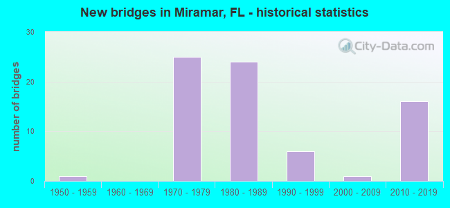
- New bridges - historical statistics
- 11950-1959
- 251970-1979
- 241980-1989
- 61990-1999
- 12000-2009
- 162010-2019

- Reconstructed bridges - Historical Statistics
- 12000-2009
- 22010-2019


- Bridge Condition - Deck
- 25.0%Very good
- 56.3%Good
- 15.6%Satisfactory
- 3.1%Fair

- Bridge Condition - Superstructure
- 34.4%Very good
- 53.1%Good
- 9.4%Satisfactory
- 3.1%Fair

- Bridge Condition - Substructure
- 28.1%Very good
- 71.9%Good

- Bridge Condition - Channel
- 5.9%Excellent
- 11.8%Very good
- 70.6%Good
- 11.8%Satisfactory
Find on map >> Show street view
Structure Number: 860069, Location: 0.2 MI. SO. OF 852 ON TPK (Lat: 25.971642, Lng: -80.229736), Route carried "on" structure: Ramp State highway 821, Year Built: 1994, Status: Open, Structure Length: 57.76m (189.50ft), Average Daily Traffic: 6,500 (year 2021), Truck Traffic: 11%, Average Future Daily Traffic: 11,278 (year 2042), Design Load: HS 20+Mod, Features Intersected: SR 91 & SR 852, Facility Carried by Structure: SR91 NB TPK 3.268
Minimum Vertical Clearance: 30+ m (98+ ft), Kilometerpoint: 0.135, Lanes on structure: 1, Lanes under structure: 17, Toll: On toll road, Owner: State Toll Authority, Approaching Roadway Width: 8.2m (26.9ft), Material/Design: Steel continuous, Design/Construction: Stringer/Multi-beam, Number Of Spans In Main Unit: 12, Length of Maximum Span: 60.9m (199.8ft), Curb-To-Curb Width: 8.2m (26.9ft), Out-to-Out Width: 9.1m (29.9ft)
Condition: Deck: Satisfactory, Superstructure: Good, Substructure: Good, Inventory Rating: 71.4 metric tons, Method Used To Determine Inventory Rating: Load Factor (LF), Structural Evaluation: Better than present minimum criteria, Deck Geometry: Superior to present desirable criteria, Underclear: Meets minimum limits, Approach Roadway Alignment: Equal to present minimum criteria, Designated Inspection Frequency: Every 24 months, Inspection Date: October 2021, Deck Structure Type: Concrete Cast-file-Place
Find on map >> Show street view
Structure Number: 860088, Location: 6.6 MI W OF SR-91 (TPK) (Lat: 25.964175, Lng: -80.332778), Route carried "on" structure: State highway 821, Year Built: 1973, Status: Open, Structure Length: 8.16m (26.77ft), Average Daily Traffic: 36,900 (year 2021), Truck Traffic: 8%, Average Future Daily Traffic: 64,022 (year 2042), Design Load: HS 20+Mod, Features Intersected: SNAKE CREEK CANAL
Minimum Vertical Clearance: 30+ m (98+ ft), Kilometerpoint: 1.175, Lanes on structure: 2, Base Highway Network: Yes, Toll: On toll road, Owner: State Toll Authority, Approaching Roadway Width: 13.1m (43.0ft), Skew: 4 degrees, Material/Design: Prestressed concrete, Design/Construction: Stringer/Multi-beam, Number Of Spans In Main Unit: 5, Length of Maximum Span: 20.1m (65.9ft), Curb-To-Curb Width: 12.2m (40.0ft), Out-to-Out Width: 13.2m (43.3ft)
Condition: Deck: Satisfactory, Superstructure: Good, Substructure: Good, Channel: Good, Operating Rating: 47.7 metric tons, Method Used To Determine Operating Rating: Load and Resistance Factor (LRFR), Inventory Rating: 36.8 metric tons, Method Used To Determine Inventory Rating: Load and Resistance Factor (LRFR), Structural Evaluation: Better than present minimum criteria, Deck Geometry: Better than present minimum criteria, Waterway Adequacy: Superior to present desirable criteria, Approach Roadway Alignment: Equal to present desirable criteria, Designated Inspection Frequency: Every 24 months, Underwater Inspection Frequency: Every 24 months, Inspection Date: August 2021, Underwater Inspection Date: August 2021, Deck Structure Type: Concrete Cast-file-Place
Find on map >> Show street view
Structure Number: 860089, Location: 5.1 MI WEST SR-91 (TPK) (Lat: 25.970861, Lng: -80.311167), Route carried "on" structure: State highway 821, Year Built: 1973, Year Reconstructed: 2021, Status: Open, Structure Length: 8.53m (27.99ft), Average Daily Traffic: 66,890 (year 2021), Truck Traffic: 8%, Average Future Daily Traffic: 101,900 (year 2042), Design Load: HS 20+Mod, Features Intersected: FLAMINGO RD & CANAL
Minimum Vertical Clearance: 30.45m (99.90ft), Kilometerpoint: 3.531, Lanes on structure: 4, Lanes under structure: 4, Base Highway Network: Yes, Toll: On toll road, Owner: State Toll Authority, Approaching Roadway Width: 23.0m (75.5ft), Material/Design: Prestressed concrete, Design/Construction: Stringer/Multi-beam, Number Of Spans In Main Unit: 5, Length of Maximum Span: 18.5m (60.7ft), Curb-To-Curb Width: 23.0m (75.5ft), Out-to-Out Width: 23.6m (77.4ft)
Condition: Deck: Good, Superstructure: Good, Substructure: Good, Channel: Good, Operating Rating: 48.2 metric tons, Method Used To Determine Operating Rating: Load and Resistance Factor (LRFR), Inventory Rating: 37.1 metric tons, Method Used To Determine Inventory Rating: Load and Resistance Factor (LRFR), Structural Evaluation: Better than present minimum criteria, Deck Geometry: Superior to present desirable criteria, Underclear: Meets minimum limits, Waterway Adequacy: Superior to present desirable criteria, Approach Roadway Alignment: Equal to present desirable criteria, Designated Inspection Frequency: Every 24 months, Underwater Inspection Frequency: Every 24 months, Inspection Date: August 2021, Underwater Inspection Date: August 2021, Deck Structure Type: Concrete Cast-file-Place
Find on map >> Show street view
Structure Number: 86009, Location: 4.1 MI W OF SR-91 (TPK) (Lat: 25.971533, Lng: -80.278478), Route carried "on" structure: State highway 821, Year Built: 1973, Year Reconstructed: 2021, Status: Open, Structure Length: 9.49m (31.14ft), Average Daily Traffic: 77,750 (year 2021), Truck Traffic: 10%, Average Future Daily Traffic: 117,400 (year 2042), Design Load: HS 20, Features Intersected: SR 847 PALM AVE & CANAL
Minimum Vertical Clearance: 30+ m (98+ ft), Kilometerpoint: 6.780, Lanes on structure: 4, Lanes under structure: 5, Base Highway Network: Yes, Toll: On toll road, Owner: State Toll Authority, Approaching Roadway Width: 23.3m (76.4ft), Material/Design: Prestressed concrete, Design/Construction: Stringer/Multi-beam, Number Of Spans In Main Unit: 4, Length of Maximum Span: 30.7m (100.7ft), Curb-To-Curb Width: 23.3m (76.4ft), Out-to-Out Width: 24.2m (79.4ft)
Condition: Deck: Good, Superstructure: Very good, Substructure: Good, Channel: Good, Operating Rating: 45.7 metric tons, Method Used To Determine Operating Rating: Load and Resistance Factor (LRFR), Inventory Rating: 35.3 metric tons, Method Used To Determine Inventory Rating: Load and Resistance Factor (LRFR), Structural Evaluation: Better than present minimum criteria, Deck Geometry: Superior to present desirable criteria, Underclear: Somewhat better than minimum adequacy, Waterway Adequacy: Superior to present desirable criteria, Approach Roadway Alignment: Equal to present desirable criteria, Designated Inspection Frequency: Every 24 months, Inspection Date: August 2021, Deck Structure Type: Concrete Cast-file-Place
Find on map >> Show street view
Structure Number: 860091, Location: 2.1 MI W OF SR-91 (TPK) (Lat: 25.972014, Lng: -80.262558), Route carried "on" structure: State highway 821, Year Built: 1972, Year Reconstructed: 2021, Status: Open, Structure Length: 5.21m (17.09ft), Average Daily Traffic: 77,750 (year 2021), Truck Traffic: 9%, Average Future Daily Traffic: 117,400 (year 2042), Design Load: HS 20, Features Intersected: DOUGLAS RD
Minimum Vertical Clearance: 30+ m (98+ ft), Kilometerpoint: 8.380, Lanes on structure: 4, Lanes under structure: 4, Base Highway Network: Yes, Toll: On toll road, Owner: State Toll Authority, Approaching Roadway Width: 23.2m (76.1ft), Material/Design: Prestressed concrete, Design/Construction: Stringer/Multi-beam, Number Of Spans In Main Unit: 2, Length of Maximum Span: 26.1m (85.6ft), Curb-To-Curb Width: 23.2m (76.1ft), Out-to-Out Width: 24.2m (79.4ft)
Condition: Deck: Very good, Superstructure: Very good, Substructure: Good, Operating Rating: 45.4 metric tons, Method Used To Determine Operating Rating: Load and Resistance Factor (LRFR), Inventory Rating: 35.6 metric tons, Method Used To Determine Inventory Rating: Load and Resistance Factor (LRFR), Structural Evaluation: Better than present minimum criteria, Deck Geometry: Superior to present desirable criteria, Underclear: Superior to present desirable criteria, Approach Roadway Alignment: Equal to present desirable criteria, Designated Inspection Frequency: Every 24 months, Inspection Date: August 2021, Deck Structure Type: Concrete Cast-file-Place
Find on map >> Show street view
Structure Number: 860092, Location: 1.1 MI W OF SR-91 (TPK) (Lat: 25.972514, Lng: -80.246828), Route carried "on" structure: State highway 821, Year Built: 1972, Status: Open, Structure Length: 8.81m (28.90ft), Average Daily Traffic: 30,450 (year 2021), Truck Traffic: 8%, Average Future Daily Traffic: 52,831 (year 2042), Design Load: HS 20+Mod, Features Intersected: SR 817 UNIVERSITY &CANAL
Minimum Vertical Clearance: 30+ m (98+ ft), Kilometerpoint: 9.941, Lanes on structure: 3, Lanes under structure: 8, Base Highway Network: Yes, Toll: On toll road, Owner: State Toll Authority, Approaching Roadway Width: 20.7m (67.9ft), Material/Design: Steel, Design/Construction: Stringer/Multi-beam, Number Of Spans In Main Unit: 4, Length of Maximum Span: 36.9m (121.1ft), Curb-To-Curb Width: 19.8m (65.0ft), Out-to-Out Width: 21.3m (69.9ft)
Condition: Deck: Good, Superstructure: Good, Substructure: Good, Channel: Good, Operating Rating: 44.1 metric tons, Method Used To Determine Operating Rating: Load and Resistance Factor (LRFR), Inventory Rating: 33.9 metric tons, Method Used To Determine Inventory Rating: Load and Resistance Factor (LRFR), Structural Evaluation: Better than present minimum criteria, Deck Geometry: Superior to present desirable criteria, Underclear: High priority of corrective action, Waterway Adequacy: Equal to present desirable criteria, Approach Roadway Alignment: Equal to present desirable criteria, Designated Inspection Frequency: Every 24 months, Inspection Date: Febuary 2022, Bridge Improvement Cost: $180,000, Total Project Cost: $180,000, Deck Structure Type: Concrete Cast-file-Place
Find on map >> Show street view
Structure Number: 860093, Location: 0.1 MI N OF DADE CO. LINE (Lat: 25.973367, Lng: -80.229739), Route carried "on" structure: Ramp State highway 821, Year Built: 1972, Status: Open, Structure Length: 7.97m (26.15ft), Average Daily Traffic: 30,450 (year 2021), Truck Traffic: 8%, Average Future Daily Traffic: 52,831 (year 2042), Design Load: HS 20+Mod, Features Intersected: SR 91 TPK
Minimum Vertical Clearance: 30+ m (98+ ft), Kilometerpoint: 11.681, Lanes on structure: 2, Lanes under structure: 7, Toll: On toll road, Owner: State Toll Authority, Approaching Roadway Width: 12.8m (42.0ft), Skew: 4 degrees, Material/Design: Prestressed concrete, Design/Construction: Stringer/Multi-beam, Number Of Spans In Main Unit: 4, Length of Maximum Span: 26.7m (87.6ft), Curb-To-Curb Width: 12.2m (40.0ft), Out-to-Out Width: 12.5m (41.0ft)
Condition: Deck: Good, Superstructure: Very good, Substructure: Good, Operating Rating: 57.8 metric tons, Method Used To Determine Operating Rating: Load Factor (LF), Inventory Rating: 36.2 metric tons, Method Used To Determine Inventory Rating: Load Factor (LF), Structural Evaluation: Better than present minimum criteria, Deck Geometry: Superior to present desirable criteria, Underclear: Somewhat better than minimum adequacy, Approach Roadway Alignment: Equal to present desirable criteria, Designated Inspection Frequency: Every 24 months, Inspection Date: August 2021, Deck Structure Type: Concrete Cast-file-Place
Find on map >> Show street view
Structure Number: 860149, Location: 1.0 Mi S of Miramar Pkwy (Lat: 25.964222, Lng: -80.310806), Route carried "on" structure: County highway , Year Built: 1959, Status: Open, Structure Length: 3.84m (12.60ft), Average Daily Traffic: 17,600 (year 2020), Truck Traffic: 2%, Average Future Daily Traffic: 30,536 (year 2042), Design Load: H 20, Features Intersected: C-9 (Snake Creek Canal), Facility Carried by Structure: Flamingo Rd. SB
Minimum Vertical Clearance: 30+ m (98+ ft), Kilometerpoint: 0.797, Lanes on structure: 2, Owner: County Highway Agency, Approaching Roadway Width: 8.5m (27.9ft), Material/Design: Prestressed concrete, Design/Construction: Slab, Number Of Spans In Main Unit: 3, Length of Maximum Span: 12.8m (42.0ft), Curb or Sidewalk Widths: Left: 0.2m (0.7ft), Right: 0.2m (0.7ft), Curb-To-Curb Width: 8.4m (27.6ft), Out-to-Out Width: 10.4m (34.1ft)
Condition: Deck: Fair, Superstructure: Fair, Substructure: Good, Channel: Very good, Operating Rating: 43.5 metric tons, Method Used To Determine Operating Rating: Load Factor (LF), Inventory Rating: 24.9 metric tons, Method Used To Determine Inventory Rating: Load Factor (LF), Structural Evaluation: Somewhat better than minimum adequacy, Deck Geometry: High priority of corrective action, Waterway Adequacy: Superior to present desirable criteria, Approach Roadway Alignment: Equal to present desirable criteria, Designated Inspection Frequency: Every 24 months, Underwater Inspection Frequency: Every 24 months, Inspection Date: April 2020, Underwater Inspection Date: April 2020, Deck Structure Type: Concrete Precast Panels, Wearing Surface/Protective System: Wearing Surface: Bituminous
Find on map >> Show street view
Structure Number: 860188, Location: 6.6 MI W OF SR-91 (TPK) (Lat: 25.964147, Lng: -80.332369), Route carried "on" structure: State highway 821, Year Built: 1973, Status: Open, Structure Length: 8.13m (26.67ft), Average Daily Traffic: 36,900 (year 2021), Truck Traffic: 8%, Average Future Daily Traffic: 64,022 (year 2042), Design Load: HS 20+Mod, Features Intersected: SNAKE CREEK CANAL
Minimum Vertical Clearance: 30+ m (98+ ft), Kilometerpoint: 1.199, Lanes on structure: 2, Base Highway Network: Yes, Toll: On toll road, Owner: State Toll Authority, Approaching Roadway Width: 13.1m (43.0ft), Skew: 4 degrees, Material/Design: Prestressed concrete, Design/Construction: Stringer/Multi-beam, Number Of Spans In Main Unit: 5, Length of Maximum Span: 20.2m (66.3ft), Curb-To-Curb Width: 12.2m (40.0ft), Out-to-Out Width: 13.2m (43.3ft)
Condition: Deck: Good, Superstructure: Good, Substructure: Good, Channel: Good, Operating Rating: 47.6 metric tons, Method Used To Determine Operating Rating: Load and Resistance Factor (LRFR), Inventory Rating: 36.7 metric tons, Method Used To Determine Inventory Rating: Load and Resistance Factor (LRFR), Structural Evaluation: Better than present minimum criteria, Deck Geometry: Better than present minimum criteria, Waterway Adequacy: Superior to present desirable criteria, Approach Roadway Alignment: Equal to present desirable criteria, Designated Inspection Frequency: Every 24 months, Underwater Inspection Frequency: Every 24 months, Inspection Date: August 2021, Underwater Inspection Date: August 2021, Deck Structure Type: Concrete Cast-file-Place
Find on map >> Show street view
Structure Number: 860189, Location: 5.1 MI WEST OF SR-91(TPK) (Lat: 25.970606, Lng: -80.311206), Route carried "on" structure: State highway 821, Year Built: 1973, Year Reconstructed: 2021, Status: Open, Structure Length: 8.53m (27.99ft), Average Daily Traffic: 66,890 (year 2021), Truck Traffic: 8%, Average Future Daily Traffic: 101,900 (year 2042), Design Load: HS 20+Mod, Features Intersected: FLAMINGO RD & CANAL
Minimum Vertical Clearance: 30+ m (98+ ft), Kilometerpoint: 3.531, Lanes on structure: 4, Lanes under structure: 4, Base Highway Network: Yes, Toll: On toll road, Owner: State Toll Authority, Approaching Roadway Width: 23.3m (76.4ft), Material/Design: Prestressed concrete, Design/Construction: Stringer/Multi-beam, Number Of Spans In Main Unit: 5, Length of Maximum Span: 18.5m (60.7ft), Curb-To-Curb Width: 23.3m (76.4ft), Out-to-Out Width: 24.2m (79.4ft)
Condition: Deck: Satisfactory, Superstructure: Very good, Substructure: Very good, Channel: Good, Operating Rating: 48.2 metric tons, Method Used To Determine Operating Rating: Load and Resistance Factor (LRFR), Inventory Rating: 37.1 metric tons, Method Used To Determine Inventory Rating: Load and Resistance Factor (LRFR), Structural Evaluation: Equal to present desirable criteria, Deck Geometry: Superior to present desirable criteria, Underclear: Meets minimum limits, Waterway Adequacy: Equal to present desirable criteria, Approach Roadway Alignment: Equal to present desirable criteria, Designated Inspection Frequency: Every 24 months, Underwater Inspection Frequency: Every 24 months, Inspection Date: August 2021, Underwater Inspection Date: August 2021, Deck Structure Type: Concrete Cast-file-Place
Find on map >> Show street view
Structure Number: 86019, Location: 4.1 MI W OF SR-91 (TPK) (Lat: 25.971281, Lng: -80.278475), Route carried "on" structure: State highway 821, Year Built: 1973, Year Reconstructed: 2021, Status: Open, Structure Length: 9.49m (31.14ft), Average Daily Traffic: 77,750 (year 2021), Truck Traffic: 10%, Average Future Daily Traffic: 117,400 (year 2042), Design Load: HS 20, Features Intersected: SR 847 PALM AVE & CANAL
Minimum Vertical Clearance: 30+ m (98+ ft), Kilometerpoint: 6.780, Lanes on structure: 4, Lanes under structure: 5, Base Highway Network: Yes, Toll: On toll road, Owner: State Toll Authority, Approaching Roadway Width: 22.9m (75.1ft), Material/Design: Prestressed concrete, Design/Construction: Stringer/Multi-beam, Number Of Spans In Main Unit: 4, Length of Maximum Span: 30.7m (100.7ft), Curb-To-Curb Width: 22.9m (75.1ft), Out-to-Out Width: 23.6m (77.4ft)
Condition: Deck: Good, Superstructure: Very good, Substructure: Very good, Channel: Good, Operating Rating: 46.1 metric tons, Method Used To Determine Operating Rating: Load and Resistance Factor (LRFR), Inventory Rating: 35.6 metric tons, Method Used To Determine Inventory Rating: Load and Resistance Factor (LRFR), Structural Evaluation: Equal to present desirable criteria, Deck Geometry: Superior to present desirable criteria, Underclear: Somewhat better than minimum adequacy, Waterway Adequacy: Superior to present desirable criteria, Approach Roadway Alignment: Equal to present desirable criteria, Designated Inspection Frequency: Every 24 months, Inspection Date: August 2021, Deck Structure Type: Concrete Cast-file-Place
Find on map >> Show street view
Structure Number: 860191, Location: 2.1 MI W OF SR-91 (TPK) (Lat: 25.971761, Lng: -80.262547), Route carried "on" structure: State highway 821, Year Built: 1972, Year Reconstructed: 2021, Status: Open, Structure Length: 5.21m (17.09ft), Average Daily Traffic: 77,750 (year 2021), Truck Traffic: 8%, Average Future Daily Traffic: 117,400 (year 2042), Design Load: HS 20, Features Intersected: DOUGLAS RD
Minimum Vertical Clearance: 30+ m (98+ ft), Kilometerpoint: 8.380, Lanes on structure: 4, Lanes under structure: 4, Base Highway Network: Yes, Toll: On toll road, Owner: State Toll Authority, Approaching Roadway Width: 23.2m (76.1ft), Material/Design: Prestressed concrete, Design/Construction: Stringer/Multi-beam, Number Of Spans In Main Unit: 2, Length of Maximum Span: 26.1m (85.6ft), Curb-To-Curb Width: 23.2m (76.1ft), Out-to-Out Width: 23.6m (77.4ft)
Condition: Deck: Very good, Superstructure: Very good, Substructure: Very good, Operating Rating: 45.7 metric tons, Method Used To Determine Operating Rating: Load and Resistance Factor (LRFR), Inventory Rating: 35.6 metric tons, Method Used To Determine Inventory Rating: Load and Resistance Factor (LRFR), Structural Evaluation: Equal to present desirable criteria, Deck Geometry: Superior to present desirable criteria, Underclear: Superior to present desirable criteria, Approach Roadway Alignment: Equal to present desirable criteria, Designated Inspection Frequency: Every 24 months, Inspection Date: August 2021, Deck Structure Type: Concrete Cast-file-Place
Find on map >> Show street view
Structure Number: 860192, Location: 1.1 MI W OF SR-91 (TPK) (Lat: 25.972242, Lng: -80.246844), Route carried "on" structure: State highway 821, Year Built: 1972, Status: Open, Structure Length: 8.81m (28.90ft), Average Daily Traffic: 30,450 (year 2021), Truck Traffic: 8%, Average Future Daily Traffic: 52,831 (year 2042), Design Load: HS 20+Mod, Features Intersected: SR 817 UNIVERSITY &CANAL
Minimum Vertical Clearance: 30+ m (98+ ft), Kilometerpoint: 9.941, Lanes on structure: 2, Lanes under structure: 8, Base Highway Network: Yes, Toll: On toll road, Owner: State Toll Authority, Approaching Roadway Width: 13.7m (44.9ft), Material/Design: Steel, Design/Construction: Stringer/Multi-beam, Number Of Spans In Main Unit: 4, Length of Maximum Span: 36.9m (121.1ft), Curb-To-Curb Width: 12.2m (40.0ft), Out-to-Out Width: 12.5m (41.0ft)
Condition: Deck: Satisfactory, Superstructure: Satisfactory, Substructure: Good, Channel: Good, Operating Rating: 44.7 metric tons, Method Used To Determine Operating Rating: Load and Resistance Factor (LRFR), Inventory Rating: 34.7 metric tons, Method Used To Determine Inventory Rating: Load and Resistance Factor (LRFR), Structural Evaluation: Equal to present minimum criteria, Deck Geometry: Better than present minimum criteria, Underclear: Equal to present minimum criteria, Waterway Adequacy: Equal to present desirable criteria, Approach Roadway Alignment: Equal to present desirable criteria, Designated Inspection Frequency: Every 24 months, Inspection Date: Febuary 2022, Bridge Improvement Cost: $140,000, Total Project Cost: $140,000, Deck Structure Type: Concrete Cast-file-Place
Find on map >> Show street view
Structure Number: 86032, Location: 0.8 MI N of SNAKE CREEK (Lat: 25.967806, Lng: -80.352208), Route carried "on" structure: City street , Year Built: 1982, Status: Open, Structure Length: 11.67m (38.29ft), Average Daily Traffic: 2,300 (year 2020), Truck Traffic: 9%, Average Future Daily Traffic: 3,990 (year 2042), Design Load: HS 20, Features Intersected: I-75 (SR-93), Facility Carried by Structure: BASS CREEK ROAD
Minimum Vertical Clearance: 30+ m (98+ ft), Kilometerpoint: 2.380, Lanes on structure: 2, Lanes under structure: 16, Owner: State Highway Agency, Approaching Roadway Width: 13.4m (44.0ft), Material/Design: Prestressed concrete, Design/Construction: Stringer/Multi-beam, Number Of Spans In Main Unit: 5, Length of Maximum Span: 33.8m (110.9ft), Curb-To-Curb Width: 13.4m (44.0ft), Out-to-Out Width: 14.2m (46.6ft)
Condition: Deck: Good, Superstructure: Satisfactory, Substructure: Good, Operating Rating: 54.9 metric tons, Method Used To Determine Operating Rating: Load Factor (LF), Inventory Rating: 33.0 metric tons, Method Used To Determine Inventory Rating: Load Factor (LF), Structural Evaluation: Equal to present minimum criteria, Deck Geometry: Better than present minimum criteria, Underclear: Meets minimum limits, Approach Roadway Alignment: Equal to present desirable criteria, Designated Inspection Frequency: Every 24 months, Inspection Date: September 2020, Deck Structure Type: Concrete Precast Panels
Find on map >> Show street view
Structure Number: 860327, Location: AT DADE COUNTY LINE (Lat: 25.956861, Lng: -80.352050), Route carried "on" structure: Interstate 75, Year Built: 1982, Status: Open, Structure Length: 5.85m (19.19ft), Average Daily Traffic: 78,250 (year 2020), Truck Traffic: 8%, Average Future Daily Traffic: 135,764 (year 2042), Design Load: HS 20+Mod, Features Intersected: SNAKE CREEK
Minimum Vertical Clearance: 30+ m (98+ ft), Kilometerpoint: 0.000, Lanes on structure: 5, Base Highway Network: Yes, Owner: State Highway Agency, Approaching Roadway Width: 23.5m (77.1ft), Material/Design: Prestressed concrete, Design/Construction: Stringer/Multi-beam, Number Of Spans In Main Unit: 3, Length of Maximum Span: 19.5m (64.0ft), Curb-To-Curb Width: 24.4m (80.1ft), Out-to-Out Width: 25.2m (82.7ft)
Condition: Deck: Satisfactory, Superstructure: Good, Substructure: Good, Channel: Good, Operating Rating: 39.9 metric tons, Method Used To Determine Operating Rating: Load Factor (LF), Inventory Rating: 36.7 metric tons, Method Used To Determine Inventory Rating: Load Factor (LF), Structural Evaluation: Better than present minimum criteria, Deck Geometry: Equal to present minimum criteria, Waterway Adequacy: Superior to present desirable criteria, Approach Roadway Alignment: Equal to present desirable criteria, Designated Inspection Frequency: Every 24 months, Underwater Inspection Frequency: Every 24 months, Inspection Date: September 2020, Underwater Inspection Date: September 2020, Deck Structure Type: Concrete Precast Panels
Find on map >> Show street view
Structure Number: 860328, Location: AT DADE COUNTY LINE (Lat: 25.956864, Lng: -80.351369), Route carried "on" structure: Interstate 75, Year Built: 1982, Year Reconstructed: 2011, Status: Open, Structure Length: 5.85m (19.19ft), Average Daily Traffic: 78,250 (year 2020), Truck Traffic: 8%, Average Future Daily Traffic: 135,764 (year 2042), Design Load: HS 20+Mod, Features Intersected: SNAKE CREEK
Minimum Vertical Clearance: 30+ m (98+ ft), Kilometerpoint: 0.000, Lanes on structure: 6, Base Highway Network: Yes, Owner: State Highway Agency, Approaching Roadway Width: 30.4m (99.7ft), Material/Design: Prestressed concrete, Design/Construction: Stringer/Multi-beam, Number Of Spans In Main Unit: 3, Length of Maximum Span: 19.5m (64.0ft), Curb-To-Curb Width: 30.4m (99.7ft), Out-to-Out Width: 34.7m (113.8ft)
Condition: Deck: Good, Superstructure: Good, Substructure: Good, Channel: Good, Operating Rating: 51.3 metric tons, Method Used To Determine Operating Rating: Load and Resistance Factor (LRFR), Inventory Rating: 38.8 metric tons, Method Used To Determine Inventory Rating: Load and Resistance Factor (LRFR), Structural Evaluation: Better than present minimum criteria, Deck Geometry: Superior to present desirable criteria, Waterway Adequacy: Superior to present desirable criteria, Approach Roadway Alignment: Equal to present desirable criteria, Designated Inspection Frequency: Every 24 months, Underwater Inspection Frequency: Every 24 months, Inspection Date: September 2020, Underwater Inspection Date: September 2020, Deck Structure Type: Concrete Cast-file-Place
Find on map >> Show street view
Structure Number: 860361, Location: 0.6 MI N OF DADE CO. LINE (Lat: 25.981825, Lng: -80.230072), Route carried "on" structure: City street 858, Year Built: 1979, Status: Open, Structure Length: 9.63m (31.59ft), Average Daily Traffic: 123,900 (year 2021), Truck Traffic: 11%, Average Future Daily Traffic: 214,966 (year 2042), Design Load: HS 20, Features Intersected: SR 91 TPK & CANAL, Facility Carried by Structure: MRMR PWY 47.9
Minimum Vertical Clearance: 30+ m (98+ ft), Kilometerpoint: 1.028, Lanes on structure: 6, Lanes under structure: 8, Owner: State Toll Authority, Approaching Roadway Width: 25.9m (85.0ft), Skew: 20 degrees, Material/Design: Prestressed concrete, Design/Construction: Stringer/Multi-beam, Number Of Spans In Main Unit: 4, Length of Maximum Span: 24.4m (80.1ft), Curb or Sidewalk Widths: Left: 1.5m (4.9ft), Right: 1.5m (4.9ft), Curb-To-Curb Width: 25.9m (85.0ft), Out-to-Out Width: 32.3m (106.0ft)
Condition: Deck: Good, Superstructure: Good, Substructure: Very good, Channel: Excellent, Operating Rating: 36.3 metric tons, Method Used To Determine Operating Rating: Load and Resistance Factor (LRFR), Inventory Rating: 33.0 metric tons, Method Used To Determine Inventory Rating: Load and Resistance Factor (LRFR), Structural Evaluation: Better than present minimum criteria, Deck Geometry: Equal to present minimum criteria, Underclear: Meets minimum limits, Waterway Adequacy: Equal to present desirable criteria, Approach Roadway Alignment: Equal to present minimum criteria, Designated Inspection Frequency: Every 24 months, Inspection Date: August 2021, Deck Structure Type: Concrete Cast-file-Place
Find on map >> Show street view
Structure Number: 860394, Location: 1.6 MI N OF DADE CO. LINE (Lat: 25.995125, Lng: -80.224517), Route carried "on" structure: State highway 91, Year Built: 1983, Status: Open, Structure Length: 8.23m (27.00ft), Average Daily Traffic: 61,950 (year 2021), Truck Traffic: 11%, Average Future Daily Traffic: 107,483 (year 2042), Design Load: HS 20+Mod, Features Intersected: SR 824 PEMBROKE RD
Minimum Vertical Clearance: 30+ m (98+ ft), Kilometerpoint: 2.589, Lanes on structure: 3, Lanes under structure: 6, Base Highway Network: Yes, Toll: On toll road, Owner: State Toll Authority, Approaching Roadway Width: 16.6m (54.5ft), Skew: 4 degrees, Material/Design: Prestressed concrete, Design/Construction: Stringer/Multi-beam, Number Of Spans In Main Unit: 4, Length of Maximum Span: 24.7m (81.0ft), Curb-To-Curb Width: 16.6m (54.5ft), Out-to-Out Width: 16.8m (55.1ft)
Condition: Deck: Good, Superstructure: Good, Substructure: Very good, Operating Rating: 43.5 metric tons, Method Used To Determine Operating Rating: Load and Resistance Factor (LRFR), Inventory Rating: 33.3 metric tons, Method Used To Determine Inventory Rating: Load and Resistance Factor (LRFR), Structural Evaluation: Better than present minimum criteria, Deck Geometry: Equal to present minimum criteria, Underclear: Equal to present minimum criteria, Approach Roadway Alignment: Equal to present desirable criteria, Designated Inspection Frequency: Every 24 months, Inspection Date: August 2021, Deck Structure Type: Concrete Cast-file-Place
Find on map >> Show street view
Structure Number: 860395, Location: 1.6 MI N OF DADE CO. LINE (Lat: 25.995114, Lng: -80.224289), Route carried "on" structure: State highway 91, Year Built: 1983, Status: Open, Structure Length: 8.23m (27.00ft), Average Daily Traffic: 61,950 (year 2021), Truck Traffic: 11%, Average Future Daily Traffic: 107,483 (year 2042), Design Load: HS 20+Mod, Features Intersected: SR 824 PEMBROKE RD
Minimum Vertical Clearance: 30+ m (98+ ft), Kilometerpoint: 2.622, Lanes on structure: 3, Lanes under structure: 6, Base Highway Network: Yes, Toll: On toll road, Owner: State Toll Authority, Approaching Roadway Width: 16.9m (55.4ft), Skew: 4 degrees, Material/Design: Prestressed concrete, Design/Construction: Stringer/Multi-beam, Number Of Spans In Main Unit: 4, Length of Maximum Span: 24.7m (81.0ft), Curb-To-Curb Width: 15.8m (51.8ft), Out-to-Out Width: 16.8m (55.1ft)
Condition: Deck: Good, Superstructure: Good, Substructure: Very good, Operating Rating: 43.5 metric tons, Method Used To Determine Operating Rating: Load and Resistance Factor (LRFR), Inventory Rating: 33.3 metric tons, Method Used To Determine Inventory Rating: Load and Resistance Factor (LRFR), Structural Evaluation: Better than present minimum criteria, Deck Geometry: Somewhat better than minimum adequacy, Underclear: Equal to present minimum criteria, Approach Roadway Alignment: Equal to present desirable criteria, Designated Inspection Frequency: Every 24 months, Inspection Date: August 2021, Deck Structure Type: Concrete Cast-file-Place
Find on map >> Show street view
Structure Number: 86055, Location: 1Mi S. SR858 Miramar Pkwy (Lat: 25.970917, Lng: -80.294944), Route carried "on" structure: State highway 823, Year Built: 1989, Status: Open, Structure Length: 6.64m (21.78ft), Average Daily Traffic: 50,500 (year 2020), Truck Traffic: 4%, Average Future Daily Traffic: 87,618 (year 2042), Design Load: HS 20+Mod, Features Intersected: SR-821 FL Tpk. Ext.
Minimum Vertical Clearance: 30+ m (98+ ft), Kilometerpoint: 0.000, Lanes on structure: 6, Lanes under structure: 6, Base Highway Network: Yes, Owner: State Highway Agency, Approaching Roadway Width: 26.8m (87.9ft), Skew: 20 degrees, Material/Design: Prestressed concrete, Design/Construction: Stringer/Multi-beam, Number Of Spans In Main Unit: 2, Length of Maximum Span: 33.2m (108.9ft), Curb-To-Curb Width: 37.2m (122.0ft), Out-to-Out Width: 38.0m (124.7ft)
Condition: Deck: Good, Superstructure: Good, Substructure: Good, Operating Rating: 57.1 metric tons, Method Used To Determine Operating Rating: Load Factor (LF), Inventory Rating: 49.8 metric tons, Method Used To Determine Inventory Rating: Load Factor (LF), Structural Evaluation: Better than present minimum criteria, Deck Geometry: Superior to present desirable criteria, Underclear: Equal to present minimum criteria, Approach Roadway Alignment: Equal to present desirable criteria, Designated Inspection Frequency: Every 24 months, Inspection Date: August 2020, Deck Structure Type: Concrete Cast-file-Place
Find on map >> Show street view
Structure Number: 860672, Location: 2.5 Mi South of SR-820 (Lat: 25.978611, Lng: -80.351667), Route carried "on" structure: City street , Year Built: 2017, Status: Open, Structure Length: 13.78m (45.21ft), Average Daily Traffic: 53,000 (year 2020), Truck Traffic: 5%, Average Future Daily Traffic: 91,955 (year 2042), Design Load: HL 93, Features Intersected: I-75, Facility Carried by Structure: Miramar Parkway
Minimum Vertical Clearance: 30+ m (98+ ft), Kilometerpoint: 0.389, Lanes on structure: 10, Lanes under structure: 16, Base Highway Network: Yes, Owner: State Highway Agency, Approaching Roadway Width: 43.0m (141.1ft), Skew: 22 degrees, Material/Design: Prestressed concrete, Design/Construction: Stringer/Multi-beam, Number Of Spans In Main Unit: 4, Length of Maximum Span: 44.5m (146.0ft), Curb or Sidewalk Widths: Left: 2.4m (7.9ft), Right: 2.4m (7.9ft), Curb-To-Curb Width: 43.0m (141.1ft), Out-to-Out Width: 51.5m (169.0ft)
Condition: Deck: Very good, Superstructure: Good, Substructure: Very good, Operating Rating: 38.2 metric tons, Method Used To Determine Operating Rating: Load and Resistance Factor (LRFR), Inventory Rating: 34.3 metric tons, Method Used To Determine Inventory Rating: Load and Resistance Factor (LRFR), Structural Evaluation: Better than present minimum criteria, Deck Geometry: Superior to present desirable criteria, Underclear: Somewhat better than minimum adequacy, Approach Roadway Alignment: Equal to present desirable criteria, Designated Inspection Frequency: Every 24 months, Inspection Date: March 2021, Deck Structure Type: Concrete Cast-file-Place
Find on map >> Show street view
Structure Number: 860678, Location: At Dade County Line (Lat: 25.956833, Lng: -80.351722), Route carried "on" structure: Interstate 75, Year Built: 2018, Status: Open, Structure Length: 5.82m (19.09ft), Average Daily Traffic: 25,500 (year 2020), Truck Traffic: 6%, Average Future Daily Traffic: 44,242 (year 2042), Design Load: HL 93, Features Intersected: C-9 (Snake Creek) Canal
Minimum Vertical Clearance: 30+ m (98+ ft), Kilometerpoint: 0.000, Lanes on structure: 7, Base Highway Network: Yes, Toll: On toll road, Owner: State Highway Agency, Approaching Roadway Width: 37.6m (123.4ft), Skew: 30 degrees, Material/Design: Prestressed concrete, Design/Construction: Stringer/Multi-beam, Number Of Spans In Main Unit: 3, Length of Maximum Span: 19.4m (63.6ft), Curb-To-Curb Width: 37.6m (123.4ft), Out-to-Out Width: 39.1m (128.3ft)
Condition: Deck: Very good, Superstructure: Very good, Substructure: Good, Channel: Good, Operating Rating: 40.2 metric tons, Method Used To Determine Operating Rating: Load and Resistance Factor (LRFR), Inventory Rating: 36.9 metric tons, Method Used To Determine Inventory Rating: Load and Resistance Factor (LRFR), Structural Evaluation: Better than present minimum criteria, Deck Geometry: Superior to present desirable criteria, Waterway Adequacy: Superior to present desirable criteria, Approach Roadway Alignment: Equal to present desirable criteria, Designated Inspection Frequency: Every 24 months, Underwater Inspection Frequency: Every 24 months, Inspection Date: September 2020, Underwater Inspection Date: September 2020, Deck Structure Type: Concrete Cast-file-Place
Find on map >> Show street view
Structure Number: 860679, Location: At Dade County Line (Lat: 25.956833, Lng: -80.352333), Route carried "on" structure: Ramp Interstate 75, Year Built: 2018, Status: Open, Structure Length: 6.22m (20.41ft), Average Daily Traffic: 20,000 (year 2020), Truck Traffic: 6%, Average Future Daily Traffic: 34,700 (year 2042), Design Load: HL 93, Features Intersected: SNAKE CREEK (C-9) CANAL
Minimum Vertical Clearance: 30+ m (98+ ft), Kilometerpoint: 0.552, Lanes on structure: 3, Toll: On toll road, Owner: State Highway Agency, Approaching Roadway Width: 17.1m (56.1ft), Material/Design: Prestressed concrete, Design/Construction: Stringer/Multi-beam, Number Of Spans In Main Unit: 3, Length of Maximum Span: 21.5m (70.5ft), Curb-To-Curb Width: 17.1m (56.1ft), Out-to-Out Width: 18.0m (59.1ft)
Condition: Deck: Very good, Superstructure: Very good, Substructure: Good, Channel: Very good, Operating Rating: 62.4 metric tons, Method Used To Determine Operating Rating: Load and Resistance Factor (LRFR), Inventory Rating: 44.5 metric tons, Method Used To Determine Inventory Rating: Load and Resistance Factor (LRFR), Structural Evaluation: Better than present minimum criteria, Deck Geometry: Superior to present desirable criteria, Waterway Adequacy: Superior to present desirable criteria, Approach Roadway Alignment: Equal to present desirable criteria, Designated Inspection Frequency: Every 24 months, Underwater Inspection Frequency: Every 24 months, Inspection Date: August 2020, Underwater Inspection Date: August 2020, Deck Structure Type: Concrete Cast-file-Place, Wearing Surface/Protective System: Wearing Surface: Monolithic Concrete
Find on map >> Show street view
Structure Number: 86068, Location: .17Mi N of Dade Cty Line (Lat: 25.960417, Lng: -80.352167), Route carried "on" structure: Ramp Interstate 75, Year Built: 2018, Status: Open, Structure Length: 19.28m (63.25ft), Average Daily Traffic: 20,000 (year 2020), Truck Traffic: 6%, Average Future Daily Traffic: 34,700 (year 2042), Design Load: HL 93, Features Intersected: I-75 SB, Facility Carried by Structure: Ramp H4-H12 SB
Minimum Vertical Clearance: 6.34m (20.80ft), Kilometerpoint: 0.241, Lanes on structure: 1, Lanes under structure: 5, Owner: State Highway Agency, Approaching Roadway Width: 8.2m (26.9ft), Material/Design: Steel continuous, Design/Construction: Box Beam or Girders - Single/Spread, Number Of Spans In Main Unit: 4, Length of Maximum Span: 69.8m (229.0ft), Curb-To-Curb Width: 8.2m (26.9ft), Out-to-Out Width: 9.1m (29.9ft)
Condition: Deck: Very good, Superstructure: Good, Substructure: Very good, Operating Rating: 43.5 metric tons, Method Used To Determine Operating Rating: Load and Resistance Factor (LRFR), Inventory Rating: 33.6 metric tons, Method Used To Determine Inventory Rating: Load and Resistance Factor (LRFR), Structural Evaluation: Better than present minimum criteria, Deck Geometry: Superior to present desirable criteria, Underclear: Equal to present minimum criteria, Approach Roadway Alignment: Equal to present desirable criteria, Designated Inspection Frequency: Every 24 months, Critical Feature Inspection Frequency: Every 24 months, Inspection Date: September 2020, Critical Feature Inspection Date: September 2020, Deck Structure Type: Concrete Cast-file-Place
Find on map >> Show street view
Structure Number: 86412, Location: 1.0 Mi S of Miramar Pkwy (Lat: 25.964222, Lng: -80.310667), Route carried "on" structure: County highway , Year Built: 2006, Status: Open, Structure Length: 3.84m (12.60ft), Average Daily Traffic: 19,300 (year 2020), Truck Traffic: 2%, Average Future Daily Traffic: 28,950 (year 2042), Design Load: HL 93, Features Intersected: C-9 (Snake Creek Canal), Facility Carried by Structure: Flamingo Rd. NB
Minimum Vertical Clearance: 30+ m (98+ ft), Kilometerpoint: 0.797, Lanes on structure: 2, Owner: County Highway Agency, Approaching Roadway Width: 8.5m (27.9ft), Material/Design: Prestressed concrete, Design/Construction: Slab, Number Of Spans In Main Unit: 3, Length of Maximum Span: 12.8m (42.0ft), Curb or Sidewalk Widths: Left: 0.0m, Right: 1.8m (5.9ft), Curb-To-Curb Width: 9.8m (32.2ft), Out-to-Out Width: 12.9m (42.3ft)
Condition: Deck: Very good, Superstructure: Very good, Substructure: Good, Channel: Good, Operating Rating: 50.3 metric tons, Method Used To Determine Operating Rating: Load and Resistance Factor (LRFR), Inventory Rating: 36.3 metric tons, Method Used To Determine Inventory Rating: Load and Resistance Factor (LRFR), Structural Evaluation: Better than present minimum criteria, Deck Geometry: Meets minimum limits, Waterway Adequacy: Superior to present desirable criteria, Approach Roadway Alignment: Equal to present desirable criteria, Designated Inspection Frequency: Every 24 months, Underwater Inspection Frequency: Every 24 months, Inspection Date: April 2020, Underwater Inspection Date: April 2020, Deck Structure Type: Concrete Precast Panels, Wearing Surface/Protective System: Wearing Surface: Bituminous
Find on map >> Show street view
Structure Number: 867402, Location: ADJ TO SW 148TH AVE (Lat: 25.964419, Lng: -80.343172), Route carried "on" structure: Other road , Year Built: 1974, Status: Open, Structure Length: 1.89m (6.20ft), Average Daily Traffic: 2 (year 2021), Average Future Daily Traffic: 17 (year 2041), Features Intersected: DRAINAGE CANAL, Facility Carried by Structure: BASS CK MAINT RD
Minimum Vertical Clearance: 30+ m (98+ ft), Kilometerpoint: 0.000, Lanes on structure: 2, Owner: City or Municipal Highway Agency, Approaching Roadway Width: 5.2m (17.1ft), Material/Design: Prestressed concrete, Design/Construction: Stringer/Multi-beam, Number Of Spans In Main Unit: 1, Length of Maximum Span: 18.9m (62.0ft), Curb or Sidewalk Widths: Left: 0.8m (2.6ft), Right: 0.8m (2.6ft), Curb-To-Curb Width: 7.3m (24.0ft), Out-to-Out Width: 8.8m (28.9ft)
Condition: Deck: Good, Superstructure: Good, Substructure: Good, Channel: Satisfactory, Operating Rating: 32.8 metric tons, Method Used To Determine Operating Rating: Load Factor (LF), Inventory Rating: 19.7 metric tons, Method Used To Determine Inventory Rating: Load Factor (LF), Structural Evaluation: Somewhat better than minimum adequacy, Deck Geometry: Equal to present minimum criteria, Waterway Adequacy: Better than present minimum criteria, Approach Roadway Alignment: Equal to present desirable criteria, Designated Inspection Frequency: Every 24 months, Inspection Date: March 2021, Deck Structure Type: Concrete Cast-file-Place, Wearing Surface/Protective System: Wearing Surface: Bituminous
Find on map >> Show street view
Structure Number: 867403, Location: FLAMINGO ROAD (Lat: 25.965239, Lng: -80.311069), Route carried "on" structure: Other road , Year Built: 1974, Status: Posted for load-capacity, Structure Length: 1.86m (6.10ft), Average Daily Traffic: 300 (year 2021), Truck Traffic: 5%, Average Future Daily Traffic: 360 (year 2041), Features Intersected: AT FLAMINGO CANAL, Facility Carried by Structure: N BASS CREEK ROAD
Minimum Vertical Clearance: 30+ m (98+ ft), Kilometerpoint: 0.000, Lanes on structure: 2, Owner: City or Municipal Highway Agency, Approaching Roadway Width: 6.9m (22.6ft), Material/Design: Prestressed concrete, Design/Construction: Stringer/Multi-beam, Number Of Spans In Main Unit: 1, Length of Maximum Span: 18.6m (61.0ft), Curb or Sidewalk Widths: Left: 0.0m, Right: 0.8m (2.6ft), Curb-To-Curb Width: 7.3m (24.0ft), Out-to-Out Width: 8.9m (29.2ft)
Condition: Deck: Good, Superstructure: Good, Substructure: Good, Channel: Satisfactory, Operating Rating: 86.6 metric tons, Method Used To Determine Operating Rating: Allowable Stress (AS), Inventory Rating: 26.5 metric tons, Method Used To Determine Inventory Rating: Allowable Stress (AS), Structural Evaluation: Equal to present minimum criteria, Deck Geometry: Somewhat better than minimum adequacy, Waterway Adequacy: Equal to present minimum criteria, Approach Roadway Alignment: Equal to present minimum criteria, Designated Inspection Frequency: Every 24 months, Underwater Inspection Frequency: Every 24 months, Inspection Date: March 2021, Underwater Inspection Date: March 2021, Deck Structure Type: Concrete Cast-file-Place
Find on map >> Show street view
Structure Number: 870597, Location: 0.5MI S OF BROWARD CO LN (Lat: 25.948428, Lng: -80.351667), Route carried "on" structure: Interstate 75, Year Built: 1984, Year Reconstructed: 2017, Status: Open, Structure Length: 10.24m (33.60ft), Average Daily Traffic: 70,000 (year 2020), Truck Traffic: 8%, Average Future Daily Traffic: 121,450 (year 2042), Design Load: HL 93, Features Intersected: SR-821
Minimum Vertical Clearance: 5.18m (16.99ft), Kilometerpoint: 7.846, Lanes on structure: 5, Lanes under structure: 7, Base Highway Network: Yes, Owner: State Highway Agency, Approaching Roadway Width: 23.4m (76.8ft), Skew: 4 degrees, Material/Design: Prestressed concrete, Design/Construction: Stringer/Multi-beam, Number Of Spans In Main Unit: 4, Length of Maximum Span: 35.2m (115.5ft), Curb-To-Curb Width: 24.3m (79.7ft), Out-to-Out Width: 25.3m (83.0ft)
Condition: Deck: Good, Superstructure: Good, Substructure: Good, Operating Rating: 52.3 metric tons, Method Used To Determine Operating Rating: Load and Resistance Factor (LRFR), Inventory Rating: 35.9 metric tons, Method Used To Determine Inventory Rating: Load and Resistance Factor (LRFR), Structural Evaluation: Better than present minimum criteria, Deck Geometry: Equal to present minimum criteria, Underclear: High priority of corrective action, Approach Roadway Alignment: Equal to present desirable criteria, Designated Inspection Frequency: Every 24 months, Inspection Date: August 2020, Deck Structure Type: Concrete Cast-file-Place
Find on map >> Show street view
Structure Number: 870598, Location: 0.5MI S OF BROWARD CO.LIN (Lat: 25.948944, Lng: -80.350989), Route carried "on" structure: Interstate 75, Year Built: 1983, Year Reconstructed: 2017, Status: Open, Structure Length: 10.24m (33.60ft), Average Daily Traffic: 70,250 (year 2020), Truck Traffic: 8%, Average Future Daily Traffic: 121,884 (year 2042), Design Load: HL 93, Features Intersected: SR-821
Minimum Vertical Clearance: 5.27m (17.29ft), Kilometerpoint: 7.878, Lanes on structure: 5, Lanes under structure: 4, Base Highway Network: Yes, Owner: State Highway Agency, Approaching Roadway Width: 22.3m (73.2ft), Skew: 4 degrees, Material/Design: Prestressed concrete, Design/Construction: Stringer/Multi-beam, Number Of Spans In Main Unit: 4, Length of Maximum Span: 35.3m (115.8ft), Curb-To-Curb Width: 23.2m (76.1ft), Out-to-Out Width: 24.1m (79.1ft)
Condition: Deck: Good, Superstructure: Good, Substructure: Good, Operating Rating: 53.5 metric tons, Method Used To Determine Operating Rating: Load and Resistance Factor (LRFR), Inventory Rating: 36.9 metric tons, Method Used To Determine Inventory Rating: Load and Resistance Factor (LRFR), Structural Evaluation: Better than present minimum criteria, Deck Geometry: Somewhat better than minimum adequacy, Underclear: Somewhat better than minimum adequacy, Approach Roadway Alignment: Equal to present desirable criteria, Designated Inspection Frequency: Every 24 months, Inspection Date: August 2020, Deck Structure Type: Concrete Cast-file-Place
Find on map >> Show street view
Structure Number: 870602, Location: 0.5MI S BROWARD CO.LINE (Lat: 25.948097, Lng: -80.351242), Route carried "on" structure: Ramp Interstate 75, Year Built: 1984, Status: Open, Structure Length: 64.49m (211.58ft), Average Daily Traffic: 16,500 (year 2018), Truck Traffic: 12%, Average Future Daily Traffic: 28,628 (year 2040), Design Load: HS 20, Features Intersected: SR-821/I-75
Minimum Vertical Clearance: 30+ m (98+ ft), Kilometerpoint: 0.278, Lanes on structure: 2, Lanes under structure: 23, Toll: On toll road, Owner: State Highway Agency, Approaching Roadway Width: 12.2m (40.0ft), Skew: 9 degrees, Material/Design: Prestressed concrete continuous, Design/Construction: Segmental Box Girder, Number Of Spans In Main Unit: 11, Length of Maximum Span: 67.8m (222.4ft), Curb-To-Curb Width: 12.2m (40.0ft), Out-to-Out Width: 13.0m (42.7ft)
Condition: Deck: Good, Superstructure: Satisfactory, Substructure: Good, Operating Rating: 19.6 metric tons, Method Used To Determine Operating Rating: Load and Resistance Factor (LRFR), Inventory Rating: 15.1 metric tons, Method Used To Determine Inventory Rating: Load and Resistance Factor (LRFR), Structural Evaluation: High priority of corrective action, Deck Geometry: Superior to present desirable criteria, Underclear: Somewhat better than minimum adequacy, Approach Roadway Alignment: Better than present minimum criteria, Designated Inspection Frequency: Every 24 months, Inspection Date: September 2020, Bridge Improvement Cost: $1,000,000, Total Project Cost: $2,000,000, Deck Structure Type: Concrete Cast-file-Place
Find on map >> Show street view
Structure Number: 871109, Location: I-75 & FL TPK Interchange (Lat: 25.951972, Lng: -80.351086), Route carried "on" structure: Interstate 93, Year Built: 2017, Status: Open, Structure Length: 6.49m (21.29ft), Average Daily Traffic: 81,000 (year 2019), Truck Traffic: 6%, Average Future Daily Traffic: 140,535 (year 2041), Design Load: HL 93, Features Intersected: SR 821 (FL Turnpike)
Minimum Vertical Clearance: 30+ m (98+ ft), Kilometerpoint: 8.219, Lanes on structure: 5, Lanes under structure: 1, Base Highway Network: Yes, Owner: State Highway Agency, Approaching Roadway Width: 25.6m (84.0ft), Skew: 3 degrees, Material/Design: Steel, Design/Construction: Stringer/Multi-beam, Number Of Spans In Main Unit: 1, Length of Maximum Span: 64.9m (212.9ft), Curb-To-Curb Width: 25.6m (84.0ft), Out-to-Out Width: 26.5m (86.9ft)
Condition: Deck: Good, Superstructure: Very good, Substructure: Good, Operating Rating: 53.5 metric tons, Method Used To Determine Operating Rating: Load and Resistance Factor (LRFR), Inventory Rating: 41.5 metric tons, Method Used To Determine Inventory Rating: Load and Resistance Factor (LRFR), Structural Evaluation: Better than present minimum criteria, Deck Geometry: Better than present minimum criteria, Underclear: Equal to present minimum criteria, Approach Roadway Alignment: Equal to present desirable criteria, Designated Inspection Frequency: Every 24 months, Inspection Date: December 2020, Deck Structure Type: Concrete Cast-file-Place
Find on map >> Show street view
Structure Number: 87111, Location: 3.47MI S OF SR-823 (Lat: 25.952639, Lng: -80.351944), Route carried "on" structure: Ramp Interstate 75, Year Built: 2018, Status: Open, Structure Length: 29.99m (98.39ft), Average Daily Traffic: 5,200 (year 2017), Truck Traffic: 9%, Average Future Daily Traffic: 9,022 (year 2039), Design Load: HL 93, Features Intersected: I-75/I-75 Express Lanes
Minimum Vertical Clearance: 30+ m (98+ ft), Kilometerpoint: 0.000, Lanes on structure: 2, Lanes under structure: 15, Toll: On toll road, Owner: State Highway Agency, Approaching Roadway Width: 12.2m (40.0ft), Material/Design: Steel continuous, Design/Construction: Box Beam or Girders - Single/Spread, Number Of Spans In Main Unit: 5, Length of Maximum Span: 72.4m (237.5ft), Curb-To-Curb Width: 12.2m (40.0ft), Out-to-Out Width: 13.1m (43.0ft)
Condition: Deck: Very good, Superstructure: Very good, Substructure: Very good, Operating Rating: 43.5 metric tons, Method Used To Determine Operating Rating: Load and Resistance Factor (LRFR), Inventory Rating: 33.7 metric tons, Method Used To Determine Inventory Rating: Load and Resistance Factor (LRFR), Structural Evaluation: Equal to present desirable criteria, Deck Geometry: Superior to present desirable criteria, Underclear: Equal to present minimum criteria, Approach Roadway Alignment: Better than present minimum criteria, Designated Inspection Frequency: Every 24 months, Critical Feature Inspection Frequency: Every 24 months, Inspection Date: December 2020, Critical Feature Inspection Date: December 2020, Bridge Improvement Cost: $1,000,000, Total Project Cost: $2,000,000, Deck Structure Type: Concrete Cast-file-Place
Find on map >> Show street view
Structure Number: 860069, Location: 0.2 MI. SO. OF 852 ON TPK (Lat: 25.971642, Lng: -80.229736), Route carried "under" structure: State highway 91, Year Built: 1994, Structure Length: 0. m, Average Daily Traffic: 96,600 (year 2021), Truck Traffic: 11%, Features Intersected: SR 91 & SR 852
Minimum Vertical Clearance: 7.62m (25.00ft), Kilometerpoint: 5.259, Lanes on structure: 1, Lanes under structure: 7, Toll: On toll road, Material/Design: Steel continuous, Design/Construction: Stringer/Multi-beam, Length of Maximum Span: 60.9m (199.8ft)
Find on map >> Show street view
Structure Number: 860069, Location: 0.2 MI. SO. OF 852 ON TPK (Lat: 25.971642, Lng: -80.229736), Route carried "under" structure: State highway 852, Year Built: 1994, Structure Length: 0. m, Average Daily Traffic: 26,500 (year 2021), Truck Traffic: 9%, Features Intersected: SR 91 & SR 852, Facility Carried by Structure: SR91 NB TPK 3.268
Minimum Vertical Clearance: 5.21m (17.09ft), Kilometerpoint: 5.259, Lanes on structure: 1, Lanes under structure: 5, Material/Design: Steel continuous, Design/Construction: Stringer/Multi-beam, Length of Maximum Span: 60.9m (199.8ft)
Find on map >> Show street view
Structure Number: 860069, Location: 0.2 MI. SO. OF 852 ON TPK (Lat: 25.971642, Lng: -80.229736), Route carried "under" structure: Ramp State highway 91, Year Built: 1994, Structure Length: 0. m, Average Daily Traffic: 6,500 (year 2021), Truck Traffic: 9%, Features Intersected: SR 91 & SR 852
Minimum Vertical Clearance: 7.62m (25.00ft), Kilometerpoint: 5.259, Lanes on structure: 1, Lanes under structure: 1, Toll: On toll road, Material/Design: Steel continuous, Design/Construction: Stringer/Multi-beam, Length of Maximum Span: 60.9m (199.8ft)
Find on map >> Show street view
Structure Number: 860069, Location: 0.2 MI. SO. OF 852 ON TPK (Lat: 25.971642, Lng: -80.229736), Route carried "under" structure: Ramp State highway 91, Year Built: 1994, Structure Length: 0. m, Average Daily Traffic: 13,000 (year 2021), Truck Traffic: 11%, Features Intersected: SR 91 & SR 852
Minimum Vertical Clearance: 7.62m (25.00ft), Kilometerpoint: 5.259, Lanes on structure: 1, Lanes under structure: 2, Toll: On toll road, Material/Design: Steel continuous, Design/Construction: Stringer/Multi-beam, Length of Maximum Span: 60.9m (199.8ft)
Find on map >> Show street view
Structure Number: 860069, Location: 0.2 MI. SO. OF 852 ON TPK (Lat: 25.971642, Lng: -80.229736), Route carried "under" structure: Ramp State highway 91, Year Built: 1994, Structure Length: 0. m, Average Daily Traffic: 30,450 (year 2021), Truck Traffic: 11%, Features Intersected: SR 91 & SR 852
Minimum Vertical Clearance: 4.97m (16.31ft), Kilometerpoint: 5.259, Lanes on structure: 1, Lanes under structure: 2, Toll: On toll road, Material/Design: Steel continuous, Design/Construction: Stringer/Multi-beam, Length of Maximum Span: 60.9m (199.8ft)
Find on map >> Show street view
Structure Number: 860089, Location: 5.1 MI WEST SR-91 (TPK) (Lat: 25.970861, Lng: -80.311167), Route carried "under" structure: State highway 823, Year Built: 1973, Structure Length: 0. m, Average Daily Traffic: 26,500 (year 2021), Truck Traffic: 3%, Features Intersected: FLAMINGO RD & CANAL, Facility Carried by Structure: SR821 SB HEFT 42.1
Minimum Vertical Clearance: 5.24m (17.19ft), Kilometerpoint: 1.545, Lanes on structure: 4, Lanes under structure: 4, Material/Design: Prestressed concrete, Design/Construction: Stringer/Multi-beam, Length of Maximum Span: 18.5m (60.7ft)
Find on map >> Show street view
Structure Number: 86009, Location: 4.1 MI W OF SR-91 (TPK) (Lat: 25.971533, Lng: -80.278478), Route carried "under" structure: State highway 847, Year Built: 1973, Structure Length: 0. m, Average Daily Traffic: 21,000 (year 2021), Truck Traffic: 10%, Features Intersected: SR 847 PALM AVE & CANAL, Facility Carried by Structure: SR821 SB HEFT 44.2
Minimum Vertical Clearance: 5.18m (16.99ft), Kilometerpoint: 0.074, Lanes on structure: 4, Lanes under structure: 5, Material/Design: Prestressed concrete, Design/Construction: Stringer/Multi-beam, Length of Maximum Span: 30.7m (100.7ft)
Find on map >> Show street view
Structure Number: 860091, Location: 2.1 MI W OF SR-91 (TPK) (Lat: 25.972014, Lng: -80.262558), Route carried "under" structure: City street , Year Built: 1972, Structure Length: 0. m, Average Daily Traffic: 20,000 (year 2021), Truck Traffic: 14%, Features Intersected: DOUGLAS RD, Facility Carried by Structure: SR821 SB HEFT 45.2
Minimum Vertical Clearance: 5.52m (18.11ft), Kilometerpoint: 0.000, Lanes on structure: 4, Lanes under structure: 4, Toll: On toll road, Material/Design: Prestressed concrete, Design/Construction: Stringer/Multi-beam, Length of Maximum Span: 26.1m (85.6ft)
Find on map >> Show street view
Structure Number: 860092, Location: 1.1 MI W OF SR-91 (TPK) (Lat: 25.972514, Lng: -80.246828), Route carried "under" structure: State highway 817, Year Built: 1972, Structure Length: 0. m, Average Daily Traffic: 58,000 (year 2021), Truck Traffic: 3%, Features Intersected: SR 817 UNIVERSITY &CANAL, Facility Carried by Structure: SR821 SB HEFT 46.2
Minimum Vertical Clearance: 5.67m (18.60ft), Kilometerpoint: 0.076, Lanes on structure: 3, Lanes under structure: 8, Material/Design: Steel, Design/Construction: Stringer/Multi-beam, Length of Maximum Span: 36.9m (121.1ft)
Find on map >> Show street view
Structure Number: 860093, Location: 0.1 MI N OF DADE CO. LINE (Lat: 25.973367, Lng: -80.229739), Route carried "under" structure: State highway 91, Year Built: 1972, Structure Length: 0. m, Average Daily Traffic: 123,900 (year 2021), Truck Traffic: 11%, Features Intersected: SR 91 TPK, Facility Carried by Structure: SR821 NB HEFT 47.2
Minimum Vertical Clearance: 6.31m (20.70ft), Kilometerpoint: 0.101, Lanes on structure: 2, Lanes under structure: 7, Toll: On toll road, Material/Design: Prestressed concrete, Design/Construction: Stringer/Multi-beam, Length of Maximum Span: 26.7m (87.6ft)
Find on map >> Show street view
Structure Number: 860189, Location: 5.1 MI WEST OF SR-91(TPK) (Lat: 25.970606, Lng: -80.311206), Route carried "under" structure: State highway 823, Year Built: 1973, Structure Length: 0. m, Average Daily Traffic: 25,100 (year 2021), Truck Traffic: 3%, Features Intersected: FLAMINGO RD & CANAL, Facility Carried by Structure: SR821 NB HEFT 42.2
Minimum Vertical Clearance: 4.88m (16.01ft), Kilometerpoint: 1.518, Lanes on structure: 4, Lanes under structure: 4, Material/Design: Prestressed concrete, Design/Construction: Stringer/Multi-beam, Length of Maximum Span: 18.5m (60.7ft)
Find on map >> Show street view
Structure Number: 86019, Location: 4.1 MI W OF SR-91 (TPK) (Lat: 25.971281, Lng: -80.278475), Route carried "under" structure: State highway 847, Year Built: 1973, Structure Length: 0. m, Average Daily Traffic: 21,000 (year 2021), Truck Traffic: 8%, Features Intersected: SR 847 PALM AVE & CANAL, Facility Carried by Structure: SR821 NB HEFT 44.2
Minimum Vertical Clearance: 5.36m (17.59ft), Kilometerpoint: 0.045, Lanes on structure: 4, Lanes under structure: 5, Material/Design: Prestressed concrete, Design/Construction: Stringer/Multi-beam, Length of Maximum Span: 30.7m (100.7ft)
Find on map >> Show street view
Structure Number: 860191, Location: 2.1 MI W OF SR-91 (TPK) (Lat: 25.971761, Lng: -80.262547), Route carried "under" structure: City street , Year Built: 1972, Structure Length: 0. m, Average Daily Traffic: 20,000 (year 2021), Truck Traffic: 8%, Features Intersected: DOUGLAS RD, Facility Carried by Structure: SR821 NB HEFT 45.2
Minimum Vertical Clearance: 5.49m (18.01ft), Kilometerpoint: 0.000, Lanes on structure: 4, Lanes under structure: 4, Material/Design: Prestressed concrete, Design/Construction: Stringer/Multi-beam, Length of Maximum Span: 26.1m (85.6ft)
Find on map >> Show street view
Structure Number: 860192, Location: 1.1 MI W OF SR-91 (TPK) (Lat: 25.972242, Lng: -80.246844), Route carried "under" structure: State highway 817, Year Built: 1972, Structure Length: 0. m, Average Daily Traffic: 58,000 (year 2021), Truck Traffic: 3%, Features Intersected: SR 817 UNIVERSITY &CANAL, Facility Carried by Structure: SR821 NB HEFT 46.2
Minimum Vertical Clearance: 5.33m (17.49ft), Kilometerpoint: 0.047, Lanes on structure: 2, Lanes under structure: 8, Material/Design: Steel, Design/Construction: Stringer/Multi-beam, Length of Maximum Span: 36.9m (121.1ft)
Find on map >> Show street view
Structure Number: 86032, Location: 0.8 MI N of SNAKE CREEK (Lat: 25.967806, Lng: -80.352208), Route carried "under" structure: Interstate 75, Year Built: 1982, Structure Length: 0. m, Average Daily Traffic: 25,500 (year 2020), Truck Traffic: 6%, Features Intersected: I-75 (SR-93), Facility Carried by Structure: BASS CREEK ROAD
Minimum Vertical Clearance: 4.97m (16.31ft), Kilometerpoint: 1.239, Lanes on structure: 2, Lanes under structure: 2, Toll: On toll road, Material/Design: Prestressed concrete, Design/Construction: Stringer/Multi-beam, Length of Maximum Span: 33.8m (110.9ft)
Find on map >> Show street view
Structure Number: 86032, Location: 0.8 MI N of SNAKE CREEK (Lat: 25.967806, Lng: -80.352208), Route carried "under" structure: Interstate 75, Year Built: 1982, Structure Length: 0. m, Average Daily Traffic: 25,500 (year 2020), Truck Traffic: 6%, Features Intersected: I-75 (SR-93), Facility Carried by Structure: BASS CREEK ROAD
Minimum Vertical Clearance: 4.97m (16.31ft), Kilometerpoint: 15.797, Lanes on structure: 2, Lanes under structure: 2, Toll: On toll road, Material/Design: Prestressed concrete, Design/Construction: Stringer/Multi-beam, Length of Maximum Span: 33.8m (110.9ft)
Find on map >> Show street view
Structure Number: 86032, Location: 0.8 MI N of SNAKE CREEK (Lat: 25.967806, Lng: -80.352208), Route carried "under" structure: Interstate 75, Year Built: 1982, Structure Length: 0. m, Average Daily Traffic: 156,500 (year 2020), Truck Traffic: 8%, Features Intersected: I-75 (SR-93), Facility Carried by Structure: BASS CREEK ROAD
Minimum Vertical Clearance: 5.00m (16.40ft), Kilometerpoint: 1.241, Lanes on structure: 2, Lanes under structure: 12, Material/Design: Prestressed concrete, Design/Construction: Stringer/Multi-beam, Length of Maximum Span: 33.8m (110.9ft)
Find on map >> Show street view
Structure Number: 860361, Location: 0.6 MI N OF DADE CO. LINE (Lat: 25.981825, Lng: -80.230072), Route carried "under" structure: State highway 91, Year Built: 1979, Structure Length: 0. m, Average Daily Traffic: 123,900 (year 2021), Truck Traffic: 11%, Features Intersected: SR 91 TPK & CANAL, Facility Carried by Structure: MRMR PWY 47.9
Minimum Vertical Clearance: 4.82m (15.81ft), Kilometerpoint: 1.028, Lanes on structure: 6, Lanes under structure: 8, Toll: On toll road, Material/Design: Prestressed concrete, Design/Construction: Stringer/Multi-beam, Length of Maximum Span: 24.4m (80.1ft)
Find on map >> Show street view
Structure Number: 860394, Location: 1.6 MI N OF DADE CO. LINE (Lat: 25.995125, Lng: -80.224517), Route carried "under" structure: State highway 824, Year Built: 1983, Structure Length: 0. m, Average Daily Traffic: 47,500 (year 2021), Truck Traffic: 4%, Features Intersected: SR 824 PEMBROKE RD, Facility Carried by Structure: SR91 SB TPK 48.85
Minimum Vertical Clearance: 6.00m (19.69ft), Kilometerpoint: 2.298, Lanes on structure: 3, Lanes under structure: 6, Material/Design: Prestressed concrete, Design/Construction: Stringer/Multi-beam, Length of Maximum Span: 24.7m (81.0ft)
Find on map >> Show street view
Structure Number: 860395, Location: 1.6 MI N OF DADE CO. LINE (Lat: 25.995114, Lng: -80.224289), Route carried "under" structure: State highway 824, Year Built: 1983, Structure Length: 0. m, Average Daily Traffic: 47,500 (year 2021), Truck Traffic: 4%, Features Intersected: SR 824 PEMBROKE RD, Facility Carried by Structure: SR91 NB TPK 48.87
Minimum Vertical Clearance: 5.70m (18.70ft), Kilometerpoint: 2.322, Lanes on structure: 3, Lanes under structure: 6, Material/Design: Prestressed concrete, Design/Construction: Stringer/Multi-beam, Length of Maximum Span: 24.7m (81.0ft)