Bridge Statistics for Minneola, Florida (FL)
Condition, Traffic, Stress, Structural Evaluation, Project Costs
- National Bridge Inventory (NBI) Statistics
- 12Number of bridges
- 89ft / 26.9mTotal length
- 336,155Total average daily traffic
- 64,838Total average daily truck traffic
- National Bridge Inventory (NBI) Registered Bridges for Minneola
- No street view available for this location
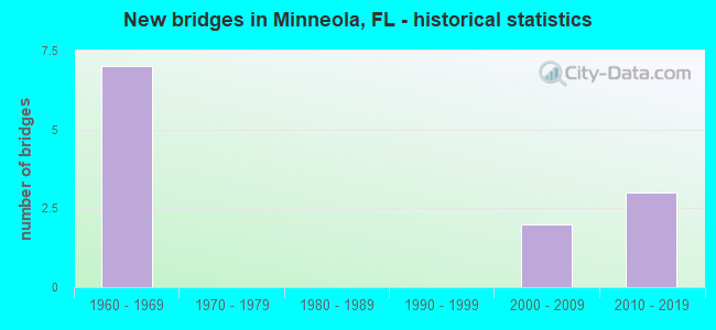
- New bridges - historical statistics
- 71960-1969
- 22000-2009
- 32010-2019


- Bridge Condition - Deck
- 16.7%Very good
- 33.3%Good
- 50.0%Satisfactory

- Bridge Condition - Superstructure
- 16.7%Very good
- 83.3%Good

- Bridge Condition - Substructure
- 50.0%Very good
- 50.0%Satisfactory
Find on map >> Show street view
Structure Number: 110069, Location: 1.2 MI S OF CR 561 (Lat: 28.614942, Lng: -81.737497), Route carried "on" structure: City street , Year Built: 1964, Status: Open, Structure Length: 7.56m (24.80ft), Average Daily Traffic: 455 (year 2005), Truck Traffic: 5%, Average Future Daily Traffic: 1,000 (year 2035), Design Load: H 20, Features Intersected: SR 91 TPK, Facility Carried by Structure: SCRUB JAY LN 280.7
Minimum Vertical Clearance: 30+ m (98+ ft), Kilometerpoint: 3.167, Lanes on structure: 2, Lanes under structure: 4, Owner: State Toll Authority, Approaching Roadway Width: 6.1m (20.0ft), Skew: 3 degrees, Material/Design: Prestressed concrete, Design/Construction: Stringer/Multi-beam, Number Of Spans In Main Unit: 4, Length of Maximum Span: 21.0m (68.9ft), Curb or Sidewalk Widths: Left: 0.6m (2.0ft), Right: 0.6m (2.0ft), Curb-To-Curb Width: 7.3m (24.0ft), Out-to-Out Width: 9.1m (29.9ft)
Condition: Deck: Satisfactory, Superstructure: Good, Substructure: Satisfactory, Operating Rating: 43.3 metric tons, Method Used To Determine Operating Rating: Load and Resistance Factor (LRFR), Inventory Rating: 39.1 metric tons, Method Used To Determine Inventory Rating: Load and Resistance Factor (LRFR), Structural Evaluation: Equal to present minimum criteria, Deck Geometry: Meets minimum limits, Underclear: High priority of corrective action, Approach Roadway Alignment: Equal to present desirable criteria, Designated Inspection Frequency: Every 24 months, Inspection Date: October 2021, Deck Structure Type: Concrete Cast-file-Place
Find on map >> Show street view
Structure Number: 11007, Location: 3.3MI S OF SR 19 (Lat: 28.623756, Lng: -81.753933), Route carried "on" structure: State highway 91, Year Built: 1964, Status: Open, Structure Length: 3.78m (12.40ft), Average Daily Traffic: 27,750 (year 2020), Truck Traffic: 21%, Average Future Daily Traffic: 48,146 (year 2042), Design Load: HS 20, Features Intersected: CR 561
Minimum Vertical Clearance: 30+ m (98+ ft), Kilometerpoint: 12.616, Lanes on structure: 2, Lanes under structure: 2, Base Highway Network: Yes, Toll: On toll road, Owner: State Toll Authority, Approaching Roadway Width: 11.8m (38.7ft), Skew: 2 degrees, Material/Design: Prestressed concrete, Design/Construction: Stringer/Multi-beam, Number Of Spans In Main Unit: 3, Length of Maximum Span: 14.3m (46.9ft), Curb-To-Curb Width: 11.6m (38.1ft), Out-to-Out Width: 13.4m (44.0ft)
Condition: Deck: Satisfactory, Superstructure: Good, Substructure: Satisfactory, Operating Rating: 49.3 metric tons, Method Used To Determine Operating Rating: Load and Resistance Factor (LRFR), Inventory Rating: 38.0 metric tons, Method Used To Determine Inventory Rating: Load and Resistance Factor (LRFR), Structural Evaluation: Equal to present minimum criteria, Deck Geometry: Equal to present minimum criteria, Underclear: Meets minimum limits, Approach Roadway Alignment: Equal to present desirable criteria, Designated Inspection Frequency: Every 24 months, Inspection Date: October 2021, Deck Structure Type: Concrete Cast-file-Place
Find on map >> Show street view
Structure Number: 110089, Location: US-27 SB over Minneola Tr (Lat: 28.573422, Lng: -81.747189), Route carried "on" structure: US 27, Year Built: 2008, Status: Open, Structure Length: 1.83m (6.00ft), Average Daily Traffic: 17,000 (year 2020), Truck Traffic: 7%, Average Future Daily Traffic: 29,495 (year 2042), Design Load: HL 93, Features Intersected: Minneola Trail
Minimum Vertical Clearance: 30+ m (98+ ft), Kilometerpoint: 26.760, Lanes on structure: 3, Base Highway Network: Yes, Owner: State Highway Agency, Approaching Roadway Width: 13.4m (44.0ft), Material/Design: Prestressed concrete, Design/Construction: Stringer/Multi-beam, Number Of Spans In Main Unit: 1, Length of Maximum Span: 17.7m (58.1ft), Curb or Sidewalk Widths: Left: 1.5m (4.9ft), Right: 0.0m, Curb-To-Curb Width: 13.4m (44.0ft), Out-to-Out Width: 16.2m (53.1ft)
Condition: Deck: Good, Superstructure: Good, Substructure: Very good, Operating Rating: 74.1 metric tons, Method Used To Determine Operating Rating: Load and Resistance Factor (LRFR), Inventory Rating: 57.2 metric tons, Method Used To Determine Inventory Rating: Load and Resistance Factor (LRFR), Structural Evaluation: Better than present minimum criteria, Deck Geometry: Somewhat better than minimum adequacy, Approach Roadway Alignment: Equal to present desirable criteria, Designated Inspection Frequency: Every 24 months, Inspection Date: November 2021, Deck Structure Type: Concrete Cast-file-Place, Wearing Surface/Protective System: Wearing Surface: Monolithic Concrete
Find on map >> Show street view
Structure Number: 11009, Location: US-27 NB over Minneola Tr (Lat: 28.573328, Lng: -81.746867), Route carried "on" structure: US 27, Year Built: 2008, Status: Open, Structure Length: 1.83m (6.00ft), Average Daily Traffic: 17,000 (year 2020), Truck Traffic: 7%, Average Future Daily Traffic: 29,495 (year 2042), Design Load: HL 93, Features Intersected: Minneola Trail
Minimum Vertical Clearance: 30+ m (98+ ft), Kilometerpoint: 26.757, Lanes on structure: 3, Base Highway Network: Yes, Owner: State Highway Agency, Approaching Roadway Width: 13.4m (44.0ft), Material/Design: Prestressed concrete, Design/Construction: Stringer/Multi-beam, Number Of Spans In Main Unit: 1, Length of Maximum Span: 17.7m (58.1ft), Curb or Sidewalk Widths: Left: 0.0m, Right: 1.5m (4.9ft), Curb-To-Curb Width: 13.4m (44.0ft), Out-to-Out Width: 16.2m (53.1ft)
Condition: Deck: Good, Superstructure: Very good, Substructure: Very good, Operating Rating: 64.0 metric tons, Method Used To Determine Operating Rating: Load and Resistance Factor (LRFR), Inventory Rating: 49.4 metric tons, Method Used To Determine Inventory Rating: Load and Resistance Factor (LRFR), Structural Evaluation: Equal to present desirable criteria, Deck Geometry: Somewhat better than minimum adequacy, Approach Roadway Alignment: Equal to present desirable criteria, Designated Inspection Frequency: Every 24 months, Inspection Date: November 2021, Deck Structure Type: Concrete Cast-file-Place, Wearing Surface/Protective System: Wearing Surface: Monolithic Concrete
Find on map >> Show street view
Structure Number: 110605, Location: 5.6MI N OF SR 50 (Lat: 28.591683, Lng: -81.712989), Route carried "on" structure: State highway 91, Year Built: 1964, Year Reconstructed: 2017, Status: Open, Structure Length: 0.61m (2.00ft), Average Daily Traffic: 61,100 (year 2020), Truck Traffic: 21%, Average Future Daily Traffic: 106,008 (year 2042), Design Load: HS 20+Mod, Features Intersected: TRIPLE E. RD.
Minimum Vertical Clearance: 30+ m (98+ ft), Kilometerpoint: 7.192, Lanes on structure: 6, Base Highway Network: Yes, Toll: On toll road, Owner: State Toll Authority, Approaching Roadway Width: 31.7m (104.0ft), Skew: 15 degrees, Material/Design: Concrete, Design/Construction: Culvert, Number Of Spans In Main Unit: 1, Length of Maximum Span: 6.1m (20.0ft), Curb-To-Curb Width: 31.7m (104.0ft), Out-to-Out Width: 56.7m (186.0ft)
Condition: Culverts: Satisfactory, Operating Rating: 40.5 metric tons, Method Used To Determine Operating Rating: Load and Resistance Factor (LRFR), Inventory Rating: 32.7 metric tons, Method Used To Determine Inventory Rating: Load and Resistance Factor (LRFR), Structural Evaluation: Equal to present minimum criteria, Deck Geometry: Superior to present desirable criteria, Approach Roadway Alignment: Equal to present desirable criteria, Designated Inspection Frequency: Every 24 months, Inspection Date: October 2021
Find on map >> Show street view
Structure Number: 110606, Location: 0.5 MI N/O TURKEY FARM RD (Lat: 28.598306, Lng: -81.718428), Route carried "on" structure: County highway , Year Built: 2017, Status: Open, Structure Length: 7.47m (24.51ft), Average Daily Traffic: 61,100 (year 2020), Truck Traffic: 21%, Average Future Daily Traffic: 106,008 (year 2042), Design Load: HL 93, Features Intersected: SR 91 TPK, Facility Carried by Structure: N Hancock Rd 279
Minimum Vertical Clearance: 30.18m (99.02ft), Kilometerpoint: 7.306, Lanes on structure: 5, Lanes under structure: 5, Owner: State Toll Authority, Approaching Roadway Width: 32.0m (105.0ft), Skew: 21 degrees, Material/Design: Prestressed concrete, Design/Construction: Stringer/Multi-beam, Number Of Spans In Main Unit: 2, Length of Maximum Span: 40.9m (134.2ft), Curb or Sidewalk Widths: Left: 3.8m (12.5ft), Right: 3.8m (12.5ft), Curb-To-Curb Width: 32.0m (105.0ft), Out-to-Out Width: 36.0m (118.1ft)
Condition: Deck: Very good, Superstructure: Good, Substructure: Very good, Operating Rating: 51.0 metric tons, Method Used To Determine Operating Rating: Load and Resistance Factor (LRFR), Inventory Rating: 32.7 metric tons, Method Used To Determine Inventory Rating: Load and Resistance Factor (LRFR), Structural Evaluation: Better than present minimum criteria, Deck Geometry: Superior to present desirable criteria, Underclear: Better than present minimum criteria, Approach Roadway Alignment: Equal to present desirable criteria, Designated Inspection Frequency: Every 24 months, Inspection Date: November 2021, Deck Structure Type: Concrete Cast-file-Place
Find on map >> Show street view
Structure Number: 11092, Location: 3.3 MI SOUTH OF SR 19 (Lat: 28.623633, Lng: -81.754133), Route carried "on" structure: State highway 91, Year Built: 1964, Status: Open, Structure Length: 3.78m (12.40ft), Average Daily Traffic: 27,750 (year 2020), Truck Traffic: 21%, Average Future Daily Traffic: 48,146 (year 2042), Design Load: HS 20, Features Intersected: CR 561
Minimum Vertical Clearance: 30+ m (98+ ft), Kilometerpoint: 12.619, Lanes on structure: 2, Lanes under structure: 2, Base Highway Network: Yes, Toll: On toll road, Owner: State Toll Authority, Approaching Roadway Width: 11.9m (39.0ft), Skew: 2 degrees, Material/Design: Prestressed concrete, Design/Construction: Stringer/Multi-beam, Number Of Spans In Main Unit: 3, Length of Maximum Span: 14.3m (46.9ft), Curb-To-Curb Width: 11.6m (38.1ft), Out-to-Out Width: 13.4m (44.0ft)
Condition: Deck: Satisfactory, Superstructure: Good, Substructure: Satisfactory, Operating Rating: 49.3 metric tons, Method Used To Determine Operating Rating: Load and Resistance Factor (LRFR), Inventory Rating: 38.0 metric tons, Method Used To Determine Inventory Rating: Load and Resistance Factor (LRFR), Structural Evaluation: Equal to present minimum criteria, Deck Geometry: Better than present minimum criteria, Underclear: Meets minimum limits, Approach Roadway Alignment: Equal to present desirable criteria, Designated Inspection Frequency: Every 24 months, Inspection Date: October 2021, Deck Structure Type: Concrete Cast-file-Place
Find on map >> Show street view
Structure Number: 110069, Location: 1.2 MI S OF CR 561 (Lat: 28.614942, Lng: -81.737497), Route carried "under" structure: State highway 91, Year Built: 1964, Structure Length: 0. m, Average Daily Traffic: 55,500 (year 2020), Truck Traffic: 21%, Features Intersected: SR 91 TPK, Facility Carried by Structure: SCRUB JAY LN 280.7
Minimum Vertical Clearance: 6.31m (20.70ft), Kilometerpoint: 10.746, Lanes on structure: 2, Lanes under structure: 4, Toll: On toll road, Material/Design: Prestressed concrete, Design/Construction: Stringer/Multi-beam, Length of Maximum Span: 21.0m (68.9ft)
Find on map >> Show street view
Structure Number: 11007, Location: 3.3MI S OF SR 19 (Lat: 28.623756, Lng: -81.753933), Route carried "under" structure: County highway 561, Year Built: 1964, Structure Length: 0. m, Average Daily Traffic: 1,050 (year 1994), Truck Traffic: 5%, Features Intersected: CR 561, Facility Carried by Structure: SR 91 TPK NB 281.9
Minimum Vertical Clearance: 4.63m (15.19ft), Kilometerpoint: 12.598, Lanes on structure: 2, Lanes under structure: 2, Material/Design: Prestressed concrete, Design/Construction: Stringer/Multi-beam, Length of Maximum Span: 14.3m (46.9ft)
Find on map >> Show street view
Structure Number: 110606, Location: 0.5 MI N/O TURKEY FARM RD (Lat: 28.598306, Lng: -81.718428), Route carried "under" structure: State highway 91, Year Built: 2017, Structure Length: 0. m, Average Daily Traffic: 61,100 (year 2020), Truck Traffic: 21%, Features Intersected: SR 91 TPK, Facility Carried by Structure: N Hancock Rd 279
Minimum Vertical Clearance: 5.46m (17.91ft), Kilometerpoint: 8.050, Lanes on structure: 5, Lanes under structure: 4, Toll: On toll road, Material/Design: Prestressed concrete, Design/Construction: Stringer/Multi-beam, Length of Maximum Span: 40.9m (134.2ft)
Find on map >> Show street view
Structure Number: 110606, Location: 0.5 MI N/O TURKEY FARM RD (Lat: 28.598306, Lng: -81.718428), Route carried "under" structure: Ramp State highway 91, Year Built: 2017, Structure Length: 0. m, Average Daily Traffic: 5,300 (year 2017), Truck Traffic: 10%, Features Intersected: SR 91 TPK, Facility Carried by Structure: N Hancock Rd 279
Minimum Vertical Clearance: 5.46m (17.91ft), Kilometerpoint: 8.050, Lanes on structure: 5, Lanes under structure: 1, Toll: On toll road, Material/Design: Prestressed concrete, Design/Construction: Stringer/Multi-beam, Length of Maximum Span: 40.9m (134.2ft)
Find on map >> Show street view
Structure Number: 11092, Location: 3.3 MI SOUTH OF SR 19 (Lat: 28.623633, Lng: -81.754133), Route carried "under" structure: County highway 561, Year Built: 1964, Structure Length: 0. m, Average Daily Traffic: 1,050 (year 1994), Truck Traffic: 5%, Features Intersected: CR 561, Facility Carried by Structure: SR 91 TPK SB 281.9
Minimum Vertical Clearance: 4.63m (15.19ft), Kilometerpoint: 12.587, Lanes on structure: 2, Lanes under structure: 2, Material/Design: Prestressed concrete, Design/Construction: Stringer/Multi-beam, Length of Maximum Span: 14.3m (46.9ft)