Bridge Statistics for Millington, Tennessee (TN)
Condition, Traffic, Stress, Structural Evaluation, Project Costs
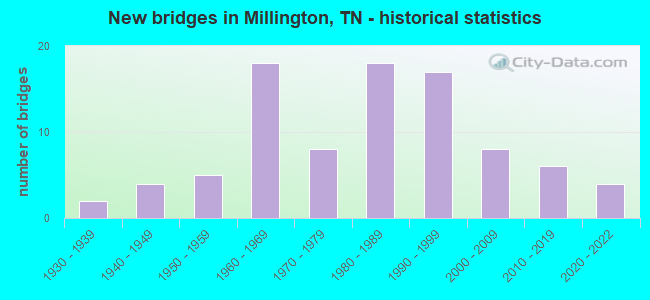
- New bridges - historical statistics
- 21930-1939
- 41940-1949
- 51950-1959
- 181960-1969
- 81970-1979
- 181980-1989
- 171990-1999
- 82000-2009
- 62010-2019
- 42020-2022

- Reconstructed bridges - Historical Statistics
- 21960-1969
- 01970-1979
- 11980-1989
- 01990-1999
- 02000-2009
- 02010-2019
- 12020-2022


- Bridge Condition - Deck
- 6.6%Very good
- 47.5%Good
- 41.0%Satisfactory
- 4.9%Fair

- Bridge Condition - Superstructure
- 21.3%Very good
- 24.6%Good
- 37.7%Satisfactory
- 11.5%Fair
- 4.9%Poor

- Bridge Condition - Substructure
- 11.5%Very good
- 44.3%Good
- 39.3%Satisfactory
- 4.9%Fair

- Bridge Condition - Channel
- 1.4%Very good
- 10.8%Good
- 78.4%Satisfactory
- 8.1%Fair
- 1.4%Poor

- Bridge Condition - Culverts
- 42.9%Good
- 38.1%Satisfactory
- 19.0%Fair
Find on map >> Show street view
Structure Number: 1TN0311, Location: 1 KM E OF SINGLETON AVE. (Lat: 35.341336, Lng: -89.855197), Route carried "on" structure: Other road , Year Built: 1942, Status: Open, Structure Length: 0.89m (2.92ft), Average Daily Traffic: 1,000 (year 2015), Truck Traffic: 10%, Average Future Daily Traffic: 1,100 (year 2037), Features Intersected: DRAINAGE CANAL, Facility Carried by Structure: ATTU STREET
Minimum Vertical Clearance: 0.00m, Kilometerpoint: 0.000, Lanes on structure: 2, Owner: Navy/Marines, Approaching Roadway Width: 5.6m (18.4ft), Material/Design: Wood or Timber, Design/Construction: Stringer/Multi-beam, Number Of Spans In Main Unit: 3, Length of Maximum Span: 2.7m (8.9ft), Curb or Sidewalk Widths: Left: 2.0m (6.6ft), Right: 2.0m (6.6ft), Curb-To-Curb Width: 7.0m (23.0ft), Out-to-Out Width: 7.7m (25.3ft)
Condition: Deck: Satisfactory, Superstructure: Fair, Substructure: Good, Channel: Good, Operating Rating: 33.6 metric tons, Method Used To Determine Operating Rating: Allowable Stress (AS), Inventory Rating: 24.8 metric tons, Method Used To Determine Inventory Rating: Allowable Stress (AS), Structural Evaluation: Somewhat better than minimum adequacy, Deck Geometry: Meets minimum limits, Waterway Adequacy: Better than present minimum criteria, Approach Roadway Alignment: Better than present minimum criteria, Length Of Structure Improvement: 0.89m (2.92ft), Designated Inspection Frequency: Every 24 months, Inspection Date: April 2021, Bridge Improvement Cost: $2,000, Roadway Improvement Cost: $36,000, Total Project Cost: $38,000 ( Estimate for 2021), Deck Structure Type: Wood or Timber, Wearing Surface/Protective System: Wearing Surface: Bituminous
Find on map >> Show street view
Structure Number: 1TN0312, Location: 0.1 KM E OF SINGLETON AVE (Lat: 35.335769, Lng: -89.867783), Route carried "on" structure: Other road , Year Built: 1947, Status: Open, Structure Length: 0.67m (2.20ft), Average Daily Traffic: 200 (year 2015), Truck Traffic: 10%, Average Future Daily Traffic: 250 (year 2037), Features Intersected: DRAINAGE CANAL, Facility Carried by Structure: HUTCHINS ROAD
Minimum Vertical Clearance: 0.00m, Kilometerpoint: 0.000, Lanes on structure: 2, Owner: Navy/Marines, Approaching Roadway Width: 9.1m (29.9ft), Material/Design: Concrete, Design/Construction: Tee Beam, Number Of Spans In Main Unit: 1, Length of Maximum Span: 6.1m (20.0ft), Curb-To-Curb Width: 9.9m (32.5ft), Out-to-Out Width: 10.4m (34.1ft)
Condition: Deck: Good, Superstructure: Good, Substructure: Good, Channel: Good, Operating Rating: 32.7 metric tons, Method Used To Determine Operating Rating: Field evaluation and documented engineering judgment, Inventory Rating: 24.5 metric tons, Method Used To Determine Inventory Rating: Field evaluation and documented engineering judgment, Structural Evaluation: Equal to present minimum criteria, Deck Geometry: Better than present minimum criteria, Waterway Adequacy: Equal to present minimum criteria, Approach Roadway Alignment: Equal to present desirable criteria, Length Of Structure Improvement: 0.67m (2.20ft), Designated Inspection Frequency: Every 24 months, Inspection Date: April 2021, Roadway Improvement Cost: $31,000, Total Project Cost: $31,000 ( Estimate for 2021), Deck Structure Type: Concrete Cast-file-Place, Wearing Surface/Protective System: Wearing Surface: Bituminous
Find on map >> Show street view
Structure Number: 1TN0313, Location: 0.1 KM E OF SINGLETON AVE (Lat: 35.331583, Lng: -89.868333), Route carried "on" structure: Other road , Year Built: 1947, Status: Open, Structure Length: 0.66m (2.17ft), Average Daily Traffic: 200 (year 2015), Truck Traffic: 10%, Average Future Daily Traffic: 250 (year 2037), Features Intersected: DRAINAGE CANAL, Facility Carried by Structure: SAVITZ DRIVE
Minimum Vertical Clearance: 0.00m, Kilometerpoint: 0.000, Lanes on structure: 2, Owner: Navy/Marines, Approaching Roadway Width: 10.4m (34.1ft), Material/Design: Concrete, Design/Construction: Tee Beam, Number Of Spans In Main Unit: 1, Length of Maximum Span: 6.1m (20.0ft), Curb-To-Curb Width: 9.9m (32.5ft), Out-to-Out Width: 10.4m (34.1ft)
Condition: Deck: Satisfactory, Superstructure: Satisfactory, Substructure: Good, Channel: Good, Operating Rating: 32.7 metric tons, Method Used To Determine Operating Rating: Field evaluation and documented engineering judgment, Inventory Rating: 24.5 metric tons, Method Used To Determine Inventory Rating: Field evaluation and documented engineering judgment, Structural Evaluation: Equal to present minimum criteria, Deck Geometry: Better than present minimum criteria, Waterway Adequacy: Equal to present minimum criteria, Approach Roadway Alignment: Equal to present desirable criteria, Length Of Structure Improvement: 0.66m (2.17ft), Designated Inspection Frequency: Every 24 months, Inspection Date: April 2021, Roadway Improvement Cost: $40,000, Total Project Cost: $40,000 ( Estimate for 2021), Deck Structure Type: Concrete Cast-file-Place, Wearing Surface/Protective System: Wearing Surface: Bituminous
Find on map >> Show street view
Structure Number: 1TN0314, Location: 0.1 KM E OF SINGLETON AVE (Lat: 35.330222, Lng: -89.868250), Route carried "on" structure: Other road , Year Built: 1947, Status: Open, Structure Length: 0.66m (2.17ft), Average Daily Traffic: 200 (year 2015), Truck Traffic: 10%, Average Future Daily Traffic: 250 (year 2037), Features Intersected: DRAINAGE CANAL, Facility Carried by Structure: SINGLETON AVE
Minimum Vertical Clearance: 0.00m, Kilometerpoint: 0.000, Lanes on structure: 2, Owner: Navy/Marines, Approaching Roadway Width: 6.7m (22.0ft), Material/Design: Concrete, Design/Construction: Tee Beam, Number Of Spans In Main Unit: 1, Length of Maximum Span: 6.1m (20.0ft), Curb-To-Curb Width: 7.9m (25.9ft), Out-to-Out Width: 10.4m (34.1ft)
Condition: Deck: Satisfactory, Superstructure: Satisfactory, Substructure: Satisfactory, Channel: Very good, Operating Rating: 32.7 metric tons, Method Used To Determine Operating Rating: Field evaluation and documented engineering judgment, Inventory Rating: 24.5 metric tons, Method Used To Determine Inventory Rating: Field evaluation and documented engineering judgment, Structural Evaluation: Equal to present minimum criteria, Deck Geometry: Somewhat better than minimum adequacy, Waterway Adequacy: Equal to present minimum criteria, Approach Roadway Alignment: Equal to present desirable criteria, Length Of Structure Improvement: 0.66m (2.17ft), Designated Inspection Frequency: Every 24 months, Inspection Date: April 2021, Roadway Improvement Cost: $40,000, Total Project Cost: $40,000 ( Estimate for 2021), Deck Structure Type: Concrete Cast-file-Place, Wearing Surface/Protective System: Wearing Surface: Bituminous
Find on map >> Show street view
Structure Number: 79002000003, Location: HOLMES RD - COLLIERVILLE (Lat: 35.006139, Lng: -89.726389), Route carried "on" structure: County highway 1450, Year Built: 1966, Status: Posted for load, Structure Length: 2.93m (9.61ft), Average Daily Traffic: 9,375 (year 2020), Truck Traffic: 4%, Average Future Daily Traffic: 2,144 (year 2041), Design Load: HS 20, Features Intersected: BRANCH
Minimum Vertical Clearance: 30+ m (98+ ft), Kilometerpoint: 34.585, Lanes on structure: 2, Owner: Town or Township Highway Agency, Approaching Roadway Width: 10.4m (34.1ft), Material/Design: Steel, Design/Construction: Stringer/Multi-beam, Number Of Spans In Main Unit: 3, Length of Maximum Span: 9.4m (30.8ft), Curb-To-Curb Width: 8.7m (28.5ft), Out-to-Out Width: 9.6m (31.5ft)
Condition: Deck: Satisfactory, Superstructure: Poor, Substructure: Satisfactory, Channel: Satisfactory, Operating Rating: 25.3 metric tons, Method Used To Determine Operating Rating: Load and Resistance Factor Rating (LRFR) rating reported by rating factor(RF) method using HL-93 loadings, Inventory Rating: 19.4 metric tons, Method Used To Determine Inventory Rating: Load and Resistance Factor Rating (LRFR) rating reported by rating factor(RF) method using HL-93 loadings, Structural Evaluation: Meets minimum limits, Deck Geometry: High priority of replacement, Waterway Adequacy: Equal to present desirable criteria, Approach Roadway Alignment: Equal to present desirable criteria, Length Of Structure Improvement: 2.93m (9.61ft), Designated Inspection Frequency: Every 24 months, Inspection Date: Febuary 2021, Bridge Improvement Cost: $500,000, Roadway Improvement Cost: $51,000, Total Project Cost: $751,000 ( Estimate for 2021), Deck Structure Type: Concrete Cast-file-Place, Wearing Surface/Protective System: Wearing Surface: Bituminous
Find on map >> Show street view
Structure Number: 79002090001, Location: SHELBY RD - MILLINGTON (Lat: 35.346139, Lng: -89.911861), Route carried "on" structure: City street 813, Year Built: 1950, Status: Open, Structure Length: 4.48m (14.70ft), Average Daily Traffic: 6,964 (year 2020), Truck Traffic: 4%, Average Future Daily Traffic: 11,142 (year 2041), Design Load: HS 20, Features Intersected: ROYSTER CREEK
Minimum Vertical Clearance: 30+ m (98+ ft), Kilometerpoint: 0.531, Lanes on structure: 4, Owner: City or Municipal Highway Agency, Approaching Roadway Width: 12.5m (41.0ft), Skew: 1 degrees, Material/Design: Prestressed concrete, Design/Construction: Box Beam or Girders - Multiple, Number Of Spans In Main Unit: 3, Length of Maximum Span: 14.9m (48.9ft), Curb or Sidewalk Widths: Left: 1.8m (5.9ft), Right: 1.8m (5.9ft), Curb-To-Curb Width: 16.0m (52.5ft), Out-to-Out Width: 16.6m (54.5ft)
Condition: Deck: Satisfactory, Superstructure: Fair, Substructure: Satisfactory, Channel: Satisfactory, Operating Rating: 44.1 metric tons, Method Used To Determine Operating Rating: Assigned rating based on Load Factor Design (LFD) reported in metric tons, Inventory Rating: 32.4 metric tons, Method Used To Determine Inventory Rating: Assigned rating based on Load Factor Design (LFD) reported in metric tons, Structural Evaluation: Somewhat better than minimum adequacy, Deck Geometry: Meets minimum limits, Waterway Adequacy: Equal to present desirable criteria, Approach Roadway Alignment: Equal to present desirable criteria, Designated Inspection Frequency: Every 24 months, Inspection Date: January 2021, Deck Structure Type: Other, Wearing Surface/Protective System: Wearing Surface: Bituminous
Find on map >> Show street view
Structure Number: 79008030003, Location: RALEIGH-MILLINGTON RD-MIL (Lat: 35.332806, Lng: -89.898167), Route carried "on" structure: City street 803, Year Built: 1955, Status: Closed, Structure Length: 5.30m (17.39ft), Average Daily Traffic: 22,476 (year 2020), Truck Traffic: 4%, Average Future Daily Traffic: 35,962 (year 2041), Design Load: H 15, Features Intersected: BIG CREEK CANAL
Minimum Vertical Clearance: 30+ m (98+ ft), Kilometerpoint: 14.726, Lanes on structure: 2, Owner: City or Municipal Highway Agency, Approaching Roadway Width: 8.5m (27.9ft), Material/Design: Steel, Design/Construction: Stringer/Multi-beam, Number Of Spans In Main Unit: 5, Length of Maximum Span: 15.2m (49.9ft), Curb or Sidewalk Widths: Left: 1.8m (5.9ft), Right: 0.0m, Curb-To-Curb Width: 8.5m (27.9ft), Out-to-Out Width: 11.3m (37.1ft)
Condition: Deck: Satisfactory, Superstructure: Poor, Substructure: Fair, Channel: Satisfactory, Waterway Adequacy: Equal to present desirable criteria, Approach Roadway Alignment: Equal to present desirable criteria, Bridge Posting: Required (Relationship of Operating Rating to Maximum Legal Load: > 39.9% below), Length Of Structure Improvement: 6.33m (20.77ft), Designated Inspection Frequency: Every 24 months, Inspection Date: January 2021, Bridge Improvement Cost: $1,696,000, Roadway Improvement Cost: $170,000, Total Project Cost: $2,545,000 ( Estimate for 2021), Deck Structure Type: Concrete Cast-file-Place, Wearing Surface/Protective System: Wearing Surface: Bituminous
Find on map >> Show street view
Structure Number: 79008030004, Location: RALEIGH-MILLINGTON RD-MIL (Lat: 35.332806, Lng: -89.898389), Route carried "on" structure: City street 803, Year Built: 1976, Status: Open, Structure Length: 5.36m (17.59ft), Average Daily Traffic: 22,476 (year 2020), Truck Traffic: 4%, Average Future Daily Traffic: 30,000 (year 2041), Design Load: HS 20, Features Intersected: BIG CREEK CANAL
Minimum Vertical Clearance: 30+ m (98+ ft), Kilometerpoint: 14.726, Lanes on structure: 2, Owner: City or Municipal Highway Agency, Approaching Roadway Width: 8.5m (27.9ft), Skew: 20 degrees, Material/Design: Prestressed concrete, Design/Construction: Box Beam or Girders - Multiple, Number Of Spans In Main Unit: 5, Length of Maximum Span: 15.2m (49.9ft), Curb or Sidewalk Widths: Left: 0.0m, Right: 1.8m (5.9ft), Curb-To-Curb Width: 8.5m (27.9ft), Out-to-Out Width: 11.5m (37.7ft)
Condition: Deck: Fair, Superstructure: Fair, Substructure: Fair, Channel: Satisfactory, Operating Rating: 36.0 metric tons, Method Used To Determine Operating Rating: Field evaluation and documented engineering judgment, Inventory Rating: 24.3 metric tons, Method Used To Determine Inventory Rating: Field evaluation and documented engineering judgment, Structural Evaluation: Somewhat better than minimum adequacy, Deck Geometry: High priority of replacement, Waterway Adequacy: Equal to present desirable criteria, Approach Roadway Alignment: Equal to present desirable criteria, Length Of Structure Improvement: 5.36m (17.59ft), Designated Inspection Frequency: Every 24 months, Inspection Date: January 2021, Bridge Improvement Cost: $499,000, Roadway Improvement Cost: $50,000, Total Project Cost: $749,000 ( Estimate for 2021), Deck Structure Type: Other, Wearing Surface/Protective System: Wearing Surface: Bituminous
Find on map >> Show street view
Structure Number: 79008040051, Location: 0.68 MI. W OF SR-14 JCT. (Lat: 35.344150, Lng: -89.800283), Route carried "on" structure: State highway 205, Year Built: 2005, Status: Open, Structure Length: 1.55m (5.09ft), Average Daily Traffic: 1,027 (year 2020), Truck Traffic: 4%, Average Future Daily Traffic: 1,904 (year 2041), Design Load: HS 20, Features Intersected: BRANCH
Minimum Vertical Clearance: 30+ m (98+ ft), Kilometerpoint: 1.094, Lanes on structure: 2, Owner: State Highway Agency, Approaching Roadway Width: 12.2m (40.0ft), Material/Design: Concrete continuous, Design/Construction: Culvert, Number Of Spans In Main Unit: 3, Length of Maximum Span: 4.9m (16.1ft)
Condition: Channel: Satisfactory, Culverts: Satisfactory, Operating Rating: 54.0 metric tons, Method Used To Determine Operating Rating: Field evaluation and documented engineering judgment, Inventory Rating: 32.4 metric tons, Method Used To Determine Inventory Rating: Field evaluation and documented engineering judgment, Structural Evaluation: Equal to present minimum criteria, Waterway Adequacy: Equal to present desirable criteria, Approach Roadway Alignment: Equal to present desirable criteria, Designated Inspection Frequency: Every 24 months, Inspection Date: November 2020
Find on map >> Show street view
Structure Number: 79008040053, Location: 1.05 MI W OF SR-14 JCT. (Lat: 35.342111, Lng: -89.806278), Route carried "on" structure: State highway 205, Year Built: 1966, Year Reconstructed: 2020, Status: Open, Structure Length: 5.12m (16.80ft), Average Daily Traffic: 1,027 (year 2020), Truck Traffic: 4%, Average Future Daily Traffic: 1,643 (year 2041), Design Load: HS 20, Features Intersected: BIG CREEK DRAINAGE DITCH
Minimum Vertical Clearance: 30+ m (98+ ft), Kilometerpoint: 1.706, Lanes on structure: 2, Owner: State Highway Agency, Approaching Roadway Width: 13.4m (44.0ft), Material/Design: Concrete, Design/Construction: Box Beam or Girders - Multiple, Number Of Spans In Main Unit: 5, Length of Maximum Span: 10.1m (33.1ft), Curb-To-Curb Width: 8.5m (27.9ft), Out-to-Out Width: 9.9m (32.5ft)
Condition: Deck: Very good, Superstructure: Good, Substructure: Good, Channel: Satisfactory, Operating Rating: 44.1 metric tons, Method Used To Determine Operating Rating: Assigned rating based on Load Factor Design (LFD) reported in metric tons, Inventory Rating: 32.4 metric tons, Method Used To Determine Inventory Rating: Assigned rating based on Load Factor Design (LFD) reported in metric tons, Structural Evaluation: Better than present minimum criteria, Deck Geometry: Somewhat better than minimum adequacy, Waterway Adequacy: Equal to present minimum criteria, Approach Roadway Alignment: Equal to present desirable criteria, Length Of Structure Improvement: 6.14m (20.14ft), Designated Inspection Frequency: Every 24 months, Inspection Date: November 2020, Bridge Improvement Cost: $1,324,000, Roadway Improvement Cost: $133,000, Total Project Cost: $1,987,000 ( Estimate for 2021), Deck Structure Type: Concrete Cast-file-Place, Wearing Surface/Protective System: Wearing Surface: Bituminous
Find on map >> Show street view
Structure Number: 79008070001, Location: WOODSTOCK-CUBA RD (Lat: 35.299111, Lng: -89.990889), Route carried "on" structure: County highway 801, Year Built: 1966, Status: Open, Structure Length: 10.03m (32.91ft), Average Daily Traffic: 402 (year 2020), Truck Traffic: 3%, Average Future Daily Traffic: 608 (year 2041), Design Load: HS 20, Features Intersected: BIG CREEK CANAL
Minimum Vertical Clearance: 30+ m (98+ ft), Kilometerpoint: 3.444, Lanes on structure: 2, Owner: County Highway Agency, Approaching Roadway Width: 12.2m (40.0ft), Skew: 1 degrees, Material/Design: Steel continuous, Design/Construction: Stringer/Multi-beam, Number Of Spans In Main Unit: 3, Number Of Approach Spans: 2, Length of Maximum Span: 25.9m (85.0ft), Curb-To-Curb Width: 8.6m (28.2ft), Out-to-Out Width: 10.0m (32.8ft)
Condition: Deck: Satisfactory, Superstructure: Satisfactory, Substructure: Satisfactory, Channel: Satisfactory, Operating Rating: 66.6 metric tons, Method Used To Determine Operating Rating: Load Factor (LF), Inventory Rating: 32.4 metric tons, Method Used To Determine Inventory Rating: Load Factor (LF), Structural Evaluation: Equal to present minimum criteria, Deck Geometry: Somewhat better than minimum adequacy, Waterway Adequacy: Equal to present desirable criteria, Approach Roadway Alignment: Equal to present desirable criteria, Designated Inspection Frequency: Every 24 months, Inspection Date: Febuary 2021, Deck Structure Type: Concrete Cast-file-Place, Wearing Surface/Protective System: Wearing Surface: Bituminous
Find on map >> Show street view
Structure Number: 79008070003, Location: WOODSTOCK-CUBA RD (Lat: 35.321861, Lng: -89.992611), Route carried "on" structure: County highway 801, Year Built: 1966, Status: Open, Structure Length: 0.88m (2.89ft), Average Daily Traffic: 402 (year 2020), Truck Traffic: 3%, Average Future Daily Traffic: 608 (year 2041), Design Load: HS 20, Features Intersected: BRANCH
Minimum Vertical Clearance: 30+ m (98+ ft), Kilometerpoint: 6.003, Lanes on structure: 2, Owner: County Highway Agency, Approaching Roadway Width: 9.1m (29.9ft), Material/Design: Concrete continuous, Design/Construction: Culvert, Number Of Spans In Main Unit: 2, Length of Maximum Span: 3.7m (12.1ft)
Condition: Channel: Poor, Culverts: Fair, Operating Rating: 89.9 metric tons, Method Used To Determine Operating Rating: Load Factor (LF), Inventory Rating: 32.4 metric tons, Method Used To Determine Inventory Rating: Load Factor (LF), Structural Evaluation: Somewhat better than minimum adequacy, Waterway Adequacy: Better than present minimum criteria, Approach Roadway Alignment: Equal to present desirable criteria, Designated Inspection Frequency: Every 24 months, Inspection Date: Febuary 2021
Find on map >> Show street view
Structure Number: 79008070005, Location: WOODSTOCK-CUBA RD (Lat: 35.324389, Lng: -89.992667), Route carried "on" structure: County highway 801, Year Built: 1966, Status: Open, Structure Length: 0.70m (2.30ft), Average Daily Traffic: 402 (year 2020), Truck Traffic: 3%, Average Future Daily Traffic: 608 (year 2041), Design Load: HS 20, Features Intersected: BRANCH
Minimum Vertical Clearance: 30+ m (98+ ft), Kilometerpoint: 6.293, Lanes on structure: 2, Owner: County Highway Agency, Approaching Roadway Width: 9.1m (29.9ft), Material/Design: Concrete continuous, Design/Construction: Culvert, Number Of Spans In Main Unit: 2, Length of Maximum Span: 3.0m (9.8ft)
Condition: Channel: Satisfactory, Culverts: Fair, Operating Rating: 71.3 metric tons, Method Used To Determine Operating Rating: Load Factor (LF), Inventory Rating: 32.4 metric tons, Method Used To Determine Inventory Rating: Load Factor (LF), Structural Evaluation: Somewhat better than minimum adequacy, Waterway Adequacy: Better than present minimum criteria, Approach Roadway Alignment: Equal to present desirable criteria, Designated Inspection Frequency: Every 24 months, Inspection Date: Febuary 2021
Find on map >> Show street view
Structure Number: 79008130003, Location: QUITO RD - SHELBY CO (Lat: 35.386194, Lng: -89.921194), Route carried "on" structure: County highway 813, Year Built: 1988, Status: Open, Structure Length: 1.13m (3.71ft), Average Daily Traffic: 6,279 (year 2020), Truck Traffic: 3%, Average Future Daily Traffic: 10,046 (year 2041), Design Load: HS 20, Features Intersected: BRANCH
Minimum Vertical Clearance: 30+ m (98+ ft), Kilometerpoint: 5.842, Lanes on structure: 2, Owner: County Highway Agency, Approaching Roadway Width: 11.6m (38.1ft), Skew: 4 degrees, Material/Design: Concrete continuous, Design/Construction: Culvert, Number Of Spans In Main Unit: 2, Length of Maximum Span: 3.7m (12.1ft), Curb-To-Curb Width: 10.1m (33.1ft), Out-to-Out Width: 10.9m (35.8ft)
Condition: Channel: Satisfactory, Culverts: Satisfactory, Operating Rating: 89.9 metric tons, Method Used To Determine Operating Rating: Load Factor (LF), Inventory Rating: 32.4 metric tons, Method Used To Determine Inventory Rating: Load Factor (LF), Structural Evaluation: Equal to present minimum criteria, Deck Geometry: Meets minimum limits, Waterway Adequacy: Better than present minimum criteria, Approach Roadway Alignment: Equal to present desirable criteria, Designated Inspection Frequency: Every 24 months, Inspection Date: Febuary 2021, Deck Structure Type: Concrete Cast-file-Place, Wearing Surface/Protective System: Wearing Surface: Bituminous, Deck Protection: Epoxy Coated Reinforcing
Find on map >> Show street view
Structure Number: 79014600001, Location: LITTLEJOHN RD - SHELBY CO (Lat: 35.308056, Lng: -89.981944), Route carried "on" structure: County highway 106, Year Built: 1989, Status: Open, Structure Length: 5.97m (19.59ft), Average Daily Traffic: 20 (year 2022), Truck Traffic: 2%, Average Future Daily Traffic: 32 (year 2041), Design Load: HS 20, Features Intersected: BIG CREEK
Minimum Vertical Clearance: 30+ m (98+ ft), Kilometerpoint: 2.192, Lanes on structure: 2, Owner: County Highway Agency, Approaching Roadway Width: 11.6m (38.1ft), Material/Design: Prestressed concrete continuous, Design/Construction: Stringer/Multi-beam, Number Of Spans In Main Unit: 3, Length of Maximum Span: 20.7m (67.9ft), Curb-To-Curb Width: 10.4m (34.1ft), Out-to-Out Width: 11.0m (36.1ft)
Condition: Deck: Satisfactory, Superstructure: Good, Substructure: Good, Channel: Satisfactory, Operating Rating: 44.1 metric tons, Method Used To Determine Operating Rating: Assigned rating based on Load Factor Design (LFD) reported in metric tons, Inventory Rating: 32.4 metric tons, Method Used To Determine Inventory Rating: Assigned rating based on Load Factor Design (LFD) reported in metric tons, Structural Evaluation: Better than present minimum criteria, Deck Geometry: Superior to present desirable criteria, Waterway Adequacy: Equal to present desirable criteria, Approach Roadway Alignment: Equal to present desirable criteria, Designated Inspection Frequency: Every 24 months, Inspection Date: Febuary 2021, Deck Structure Type: Concrete Precast Panels, Wearing Surface/Protective System: Wearing Surface: Monolithic Concrete, Deck Protection: Epoxy Coated Reinforcing
Find on map >> Show street view
Structure Number: 79014620003, Location: SHELBY RD - SHELBY CO (Lat: 35.353694, Lng: -89.949167), Route carried "on" structure: County highway 1462, Year Built: 1970, Status: Open, Structure Length: 2.59m (8.50ft), Average Daily Traffic: 678 (year 2020), Truck Traffic: 3%, Average Future Daily Traffic: 1,104 (year 2041), Design Load: H 15, Features Intersected: BEAR CREEK
Minimum Vertical Clearance: 30+ m (98+ ft), Kilometerpoint: 2.511, Lanes on structure: 2, Owner: County Highway Agency, Approaching Roadway Width: 7.3m (24.0ft), Material/Design: Concrete, Design/Construction: Channel Beam, Number Of Spans In Main Unit: 5, Length of Maximum Span: 5.2m (17.1ft), Curb-To-Curb Width: 8.6m (28.2ft), Out-to-Out Width: 10.0m (32.8ft)
Condition: Deck: Good, Superstructure: Satisfactory, Substructure: Satisfactory, Channel: Satisfactory, Operating Rating: 36.0 metric tons, Method Used To Determine Operating Rating: Field evaluation and documented engineering judgment, Inventory Rating: 24.3 metric tons, Method Used To Determine Inventory Rating: Field evaluation and documented engineering judgment, Structural Evaluation: Equal to present minimum criteria, Deck Geometry: Somewhat better than minimum adequacy, Waterway Adequacy: Equal to present desirable criteria, Approach Roadway Alignment: Equal to present desirable criteria, Designated Inspection Frequency: Every 24 months, Inspection Date: Febuary 2021, Deck Structure Type: Concrete Precast Panels, Wearing Surface/Protective System: Wearing Surface: Bituminous
Find on map >> Show street view
Structure Number: 79014620005, Location: CUBA-MILLINGTON RD-SHELBY (Lat: 35.359472, Lng: -89.974028), Route carried "on" structure: County highway 1462, Year Built: 1988, Status: Open, Structure Length: 2.65m (8.69ft), Average Daily Traffic: 678 (year 2020), Truck Traffic: 3%, Average Future Daily Traffic: 1,104 (year 2041), Design Load: HS 20, Features Intersected: JAKES CREEK
Minimum Vertical Clearance: 30+ m (98+ ft), Kilometerpoint: 5.134, Lanes on structure: 2, Owner: County Highway Agency, Approaching Roadway Width: 9.8m (32.2ft), Material/Design: Prestressed concrete continuous, Design/Construction: Box Beam or Girders - Single/Spread, Number Of Spans In Main Unit: 5, Length of Maximum Span: 5.5m (18.0ft), Curb-To-Curb Width: 11.4m (37.4ft), Out-to-Out Width: 12.0m (39.4ft)
Condition: Deck: Good, Superstructure: Fair, Substructure: Satisfactory, Channel: Fair, Operating Rating: 44.1 metric tons, Method Used To Determine Operating Rating: Assigned rating based on Load Factor Design (LFD) reported in metric tons, Inventory Rating: 32.4 metric tons, Method Used To Determine Inventory Rating: Assigned rating based on Load Factor Design (LFD) reported in metric tons, Structural Evaluation: Somewhat better than minimum adequacy, Deck Geometry: Better than present minimum criteria, Waterway Adequacy: Equal to present desirable criteria, Approach Roadway Alignment: Equal to present desirable criteria, Designated Inspection Frequency: Every 24 months, Inspection Date: Febuary 2021, Deck Structure Type: Concrete Precast Panels, Wearing Surface/Protective System: Wearing Surface: Bituminous, Membrane: Built-up, Deck Protection: Epoxy Coated Reinforcing
Find on map >> Show street view
Structure Number: 79014630001, Location: SLEDGE RD. - SHELBY CO. (Lat: 35.326083, Lng: -89.830750), Route carried "on" structure: County highway 1463, Year Built: 2017, Status: Open, Structure Length: 5.12m (16.80ft), Average Daily Traffic: 6,608 (year 2020), Truck Traffic: 3%, Average Future Daily Traffic: 3,648 (year 2041), Design Load: HL 93, Features Intersected: BIG CREEK
Minimum Vertical Clearance: 30+ m (98+ ft), Kilometerpoint: 1.127, Lanes on structure: 2, Owner: County Highway Agency, Approaching Roadway Width: 11.5m (37.7ft), Skew: 8 degrees, Material/Design: Prestressed concrete continuous, Design/Construction: Stringer/Multi-beam, Number Of Spans In Main Unit: 3, Length of Maximum Span: 22.9m (75.1ft), Curb-To-Curb Width: 11.5m (37.7ft), Out-to-Out Width: 12.2m (40.0ft)
Condition: Deck: Very good, Superstructure: Very good, Substructure: Very good, Channel: Good, Operating Rating: 44.1 metric tons, Method Used To Determine Operating Rating: Assigned ratings based on Load and Resistance Factor Design (LRFD) reported by rating factor (RF) using HL93 loadings, Inventory Rating: 32.4 metric tons, Method Used To Determine Inventory Rating: Assigned ratings based on Load and Resistance Factor Design (LRFD) reported by rating factor (RF) using HL93 loadings, Structural Evaluation: Equal to present desirable criteria, Deck Geometry: Meets minimum limits, Waterway Adequacy: Equal to present desirable criteria, Approach Roadway Alignment: Equal to present desirable criteria, Designated Inspection Frequency: Every 24 months, Inspection Date: Febuary 2021, Deck Structure Type: Concrete Cast-file-Place, Wearing Surface/Protective System: Wearing Surface: Monolithic Concrete
Find on map >> Show street view
Structure Number: 79014630003, Location: SLEDGE RD - SHELBY CO (Lat: 35.322278, Lng: -89.833556), Route carried "on" structure: County highway 1463, Year Built: 1950, Status: Posted for load, Structure Length: 2.87m (9.42ft), Average Daily Traffic: 6,608 (year 2020), Truck Traffic: 3%, Average Future Daily Traffic: 3,648 (year 2041), Design Load: HS 15, Features Intersected: BRANCH
Minimum Vertical Clearance: 30+ m (98+ ft), Kilometerpoint: 1.642, Lanes on structure: 2, Owner: County Highway Agency, Approaching Roadway Width: 10.4m (34.1ft), Material/Design: Steel, Design/Construction: Stringer/Multi-beam, Number Of Spans In Main Unit: 3, Length of Maximum Span: 9.8m (32.2ft), Curb-To-Curb Width: 8.6m (28.2ft), Out-to-Out Width: 9.5m (31.2ft)
Condition: Deck: Satisfactory, Superstructure: Poor, Substructure: Good, Channel: Good, Operating Rating: 23.0 metric tons, Method Used To Determine Operating Rating: Load and Resistance Factor Rating (LRFR) rating reported by rating factor(RF) method using HL-93 loadings, Inventory Rating: 17.8 metric tons, Method Used To Determine Inventory Rating: Load and Resistance Factor Rating (LRFR) rating reported by rating factor(RF) method using HL-93 loadings, Structural Evaluation: Meets minimum limits, Deck Geometry: High priority of replacement, Waterway Adequacy: Equal to present desirable criteria, Approach Roadway Alignment: Equal to present desirable criteria, Length Of Structure Improvement: 2.87m (9.42ft), Designated Inspection Frequency: Every 24 months, Inspection Date: Febuary 2021, Bridge Improvement Cost: $243,000, Roadway Improvement Cost: $25,000, Total Project Cost: $365,000 ( Estimate for 2021), Deck Structure Type: Concrete Cast-file-Place, Wearing Surface/Protective System: Wearing Surface: Monolithic Concrete
Find on map >> Show street view
Structure Number: 79014630005, Location: SLEDGE RD - SHELBY CO (Lat: 35.310583, Lng: -89.835111), Route carried "on" structure: County highway 1463, Year Built: 1998, Status: Open, Structure Length: 3.02m (9.91ft), Average Daily Traffic: 6,608 (year 2020), Truck Traffic: 3%, Average Future Daily Traffic: 3,648 (year 2041), Design Load: HS 20, Features Intersected: BRANCH
Minimum Vertical Clearance: 30+ m (98+ ft), Kilometerpoint: 2.945, Lanes on structure: 2, Owner: County Highway Agency, Approaching Roadway Width: 9.1m (29.9ft), Material/Design: Prestressed concrete continuous, Design/Construction: Box Beam or Girders - Multiple, Number Of Spans In Main Unit: 3, Length of Maximum Span: 9.9m (32.5ft), Curb-To-Curb Width: 9.1m (29.9ft), Out-to-Out Width: 9.8m (32.2ft)
Condition: Deck: Satisfactory, Superstructure: Very good, Substructure: Satisfactory, Channel: Satisfactory, Operating Rating: 56.7 metric tons, Method Used To Determine Operating Rating: Load Factor (LF), Inventory Rating: 32.4 metric tons, Method Used To Determine Inventory Rating: Load Factor (LF), Structural Evaluation: Equal to present minimum criteria, Deck Geometry: High priority of corrective action, Waterway Adequacy: Equal to present desirable criteria, Approach Roadway Alignment: Equal to present desirable criteria, Designated Inspection Frequency: Every 24 months, Inspection Date: Febuary 2021, Deck Structure Type: Concrete Cast-file-Place, Wearing Surface/Protective System: Wearing Surface: Monolithic Concrete, Deck Protection: Epoxy Coated Reinforcing
Find on map >> Show street view
Structure Number: 79014640001, Location: WEST UNION RD - SHELBY CO (Lat: 35.367917, Lng: -89.941889), Route carried "on" structure: County highway 1464, Year Built: 1988, Status: Open, Structure Length: 1.62m (5.31ft), Average Daily Traffic: 2,060 (year 2020), Truck Traffic: 3%, Average Future Daily Traffic: 3,968 (year 2041), Design Load: HS 20, Features Intersected: BEAR CREEK
Minimum Vertical Clearance: 30+ m (98+ ft), Kilometerpoint: 1.642, Lanes on structure: 2, Owner: County Highway Agency, Approaching Roadway Width: 13.4m (44.0ft), Material/Design: Prestressed concrete continuous, Design/Construction: Box Beam or Girders - Single/Spread, Number Of Spans In Main Unit: 3, Length of Maximum Span: 5.2m (17.1ft), Curb-To-Curb Width: 11.3m (37.1ft), Out-to-Out Width: 11.9m (39.0ft)
Condition: Deck: Good, Superstructure: Good, Substructure: Satisfactory, Channel: Fair, Operating Rating: 44.1 metric tons, Method Used To Determine Operating Rating: Assigned rating based on Load Factor Design (LFD) reported in metric tons, Inventory Rating: 32.4 metric tons, Method Used To Determine Inventory Rating: Assigned rating based on Load Factor Design (LFD) reported in metric tons, Structural Evaluation: Equal to present minimum criteria, Deck Geometry: Somewhat better than minimum adequacy, Waterway Adequacy: Equal to present desirable criteria, Approach Roadway Alignment: Equal to present desirable criteria, Designated Inspection Frequency: Every 24 months, Inspection Date: Febuary 2021, Deck Structure Type: Concrete Precast Panels, Wearing Surface/Protective System: Wearing Surface: Monolithic Concrete, Deck Protection: Epoxy Coated Reinforcing
Find on map >> Show street view
Structure Number: 79014640003, Location: WEST UNION RD - SHELBY CO (Lat: 35.368583, Lng: -89.948167), Route carried "on" structure: County highway 1464, Year Built: 1988, Status: Open, Structure Length: 1.62m (5.31ft), Average Daily Traffic: 2,060 (year 2020), Truck Traffic: 3%, Average Future Daily Traffic: 3,968 (year 2041), Design Load: HS 20, Features Intersected: BRANCH
Minimum Vertical Clearance: 30+ m (98+ ft), Kilometerpoint: 2.221, Lanes on structure: 2, Owner: County Highway Agency, Approaching Roadway Width: 13.4m (44.0ft), Material/Design: Prestressed concrete, Design/Construction: Box Beam or Girders - Single/Spread, Number Of Spans In Main Unit: 3, Length of Maximum Span: 5.2m (17.1ft), Curb-To-Curb Width: 11.3m (37.1ft), Out-to-Out Width: 11.9m (39.0ft)
Condition: Deck: Satisfactory, Superstructure: Very good, Substructure: Good, Channel: Satisfactory, Operating Rating: 44.1 metric tons, Method Used To Determine Operating Rating: Assigned rating based on Load Factor Design (LFD) reported in metric tons, Inventory Rating: 32.4 metric tons, Method Used To Determine Inventory Rating: Assigned rating based on Load Factor Design (LFD) reported in metric tons, Structural Evaluation: Better than present minimum criteria, Deck Geometry: Somewhat better than minimum adequacy, Waterway Adequacy: Equal to present desirable criteria, Approach Roadway Alignment: Equal to present desirable criteria, Designated Inspection Frequency: Every 24 months, Inspection Date: Febuary 2021, Deck Structure Type: Concrete Precast Panels, Wearing Surface/Protective System: Wearing Surface: Monolithic Concrete, Deck Protection: Epoxy Coated Reinforcing
Find on map >> Show street view
Structure Number: 79014640005, Location: HERRING HILL RD - SHELBY (Lat: 35.360639, Lng: -89.982444), Route carried "on" structure: County highway 1464, Year Built: 1999, Status: Open, Structure Length: 2.10m (6.89ft), Average Daily Traffic: 2,060 (year 2020), Truck Traffic: 3%, Average Future Daily Traffic: 3,968 (year 2041), Design Load: HS 20, Features Intersected: BRANCH
Minimum Vertical Clearance: 30+ m (98+ ft), Kilometerpoint: 6.808, Lanes on structure: 2, Owner: County Highway Agency, Approaching Roadway Width: 9.1m (29.9ft), Skew: 1 degrees, Material/Design: Prestressed concrete, Design/Construction: Box Beam or Girders - Multiple, Number Of Spans In Main Unit: 1, Length of Maximum Span: 20.1m (65.9ft), Curb-To-Curb Width: 9.1m (29.9ft), Out-to-Out Width: 9.8m (32.2ft)
Condition: Deck: Good, Superstructure: Very good, Substructure: Good, Channel: Satisfactory, Operating Rating: 44.1 metric tons, Method Used To Determine Operating Rating: Assigned rating based on Load Factor Design (LFD) reported in metric tons, Inventory Rating: 32.4 metric tons, Method Used To Determine Inventory Rating: Assigned rating based on Load Factor Design (LFD) reported in metric tons, Structural Evaluation: Better than present minimum criteria, Deck Geometry: Meets minimum limits, Waterway Adequacy: Equal to present desirable criteria, Approach Roadway Alignment: Equal to present desirable criteria, Designated Inspection Frequency: Every 24 months, Inspection Date: Febuary 2021, Deck Structure Type: Concrete Cast-file-Place, Wearing Surface/Protective System: Wearing Surface: Monolithic Concrete, Deck Protection: Epoxy Coated Reinforcing
Find on map >> Show street view
Structure Number: 79014640007, Location: WEST UNION RD-SHELBY CO (Lat: 35.370417, Lng: -89.967778), Route carried "on" structure: County highway 1464, Year Built: 1995, Status: Open, Structure Length: 0.67m (2.20ft), Average Daily Traffic: 2,060 (year 2020), Truck Traffic: 3%, Average Future Daily Traffic: 3,968 (year 2041), Design Load: HS 20, Features Intersected: BRANCH
Minimum Vertical Clearance: 30+ m (98+ ft), Kilometerpoint: 4.136, Lanes on structure: 2, Owner: County Highway Agency, Approaching Roadway Width: 9.8m (32.2ft), Material/Design: Concrete continuous, Design/Construction: Culvert, Number Of Spans In Main Unit: 2, Length of Maximum Span: 3.0m (9.8ft), Curb-To-Curb Width: 10.2m (33.5ft), Out-to-Out Width: 11.0m (36.1ft)
Condition: Channel: Satisfactory, Culverts: Satisfactory, Operating Rating: 87.5 metric tons, Method Used To Determine Operating Rating: Load Factor (LF), Inventory Rating: 32.4 metric tons, Method Used To Determine Inventory Rating: Load Factor (LF), Structural Evaluation: Equal to present minimum criteria, Deck Geometry: Meets minimum limits, Waterway Adequacy: Equal to present desirable criteria, Approach Roadway Alignment: Equal to present desirable criteria, Designated Inspection Frequency: Every 24 months, Inspection Date: Febuary 2021, Deck Structure Type: Concrete Cast-file-Place, Wearing Surface/Protective System: Wearing Surface: Monolithic Concrete, Deck Protection: Epoxy Coated Reinforcing
Find on map >> Show street view
Structure Number: 79014640009, Location: WEST UNION RD.-N. OF MEMP (Lat: 35.371361, Lng: -89.977750), Route carried "on" structure: County highway 1464, Year Built: 1975, Status: Open, Structure Length: 0.80m (2.62ft), Average Daily Traffic: 2,060 (year 2020), Truck Traffic: 3%, Average Future Daily Traffic: 3,968 (year 2041), Design Load: HS 20, Features Intersected: BRANCH
Minimum Vertical Clearance: 30+ m (98+ ft), Kilometerpoint: 5.037, Lanes on structure: 2, Owner: County Highway Agency, Approaching Roadway Width: 10.3m (33.8ft), Material/Design: Concrete continuous, Design/Construction: Culvert, Number Of Spans In Main Unit: 4, Length of Maximum Span: 3.1m (10.2ft)
Condition: Channel: Satisfactory, Culverts: Satisfactory, Operating Rating: 89.9 metric tons, Method Used To Determine Operating Rating: Load Factor (LF), Inventory Rating: 32.4 metric tons, Method Used To Determine Inventory Rating: Load Factor (LF), Structural Evaluation: Equal to present minimum criteria, Waterway Adequacy: Better than present minimum criteria, Approach Roadway Alignment: Equal to present desirable criteria, Designated Inspection Frequency: Every 24 months, Inspection Date: Febuary 2021
Find on map >> Show street view
Structure Number: 79014670001, Location: CENTER - COLLEGE RD-SHELB (Lat: 35.365889, Lng: -89.832528), Route carried "on" structure: County highway 1467, Year Built: 1963, Status: Open, Structure Length: 1.55m (5.09ft), Average Daily Traffic: 214 (year 2020), Truck Traffic: 3%, Average Future Daily Traffic: 384 (year 2041), Design Load: H 15, Features Intersected: BRANCH
Minimum Vertical Clearance: 30+ m (98+ ft), Kilometerpoint: 3.074, Lanes on structure: 2, Owner: County Highway Agency, Approaching Roadway Width: 13.4m (44.0ft), Skew: 2 degrees, Material/Design: Concrete, Design/Construction: Channel Beam, Number Of Spans In Main Unit: 3, Length of Maximum Span: 5.2m (17.1ft), Curb-To-Curb Width: 8.6m (28.2ft), Out-to-Out Width: 10.4m (34.1ft)
Condition: Deck: Fair, Superstructure: Fair, Substructure: Satisfactory, Channel: Satisfactory, Operating Rating: 36.0 metric tons, Method Used To Determine Operating Rating: Field evaluation and documented engineering judgment, Inventory Rating: 24.3 metric tons, Method Used To Determine Inventory Rating: Field evaluation and documented engineering judgment, Structural Evaluation: Somewhat better than minimum adequacy, Deck Geometry: Equal to present minimum criteria, Waterway Adequacy: Equal to present minimum criteria, Approach Roadway Alignment: Equal to present desirable criteria, Length Of Structure Improvement: 1.55m (5.09ft), Designated Inspection Frequency: Every 24 months, Inspection Date: Febuary 2021, Bridge Improvement Cost: $253,000, Roadway Improvement Cost: $26,000, Total Project Cost: $380,000 ( Estimate for 2021), Deck Structure Type: Concrete Precast Panels, Wearing Surface/Protective System: Wearing Surface: Bituminous
Find on map >> Show street view
Structure Number: 790A0280001, Location: CUBA-MILLINGTON RD-SHELBY (Lat: 35.337028, Lng: -89.989611), Route carried "on" structure: County highway 1462, Year Built: 1950, Status: Open, Structure Length: 0.67m (2.20ft), Average Daily Traffic: 678 (year 2020), Truck Traffic: 3%, Average Future Daily Traffic: 1,104 (year 2041), Design Load: HS 20, Features Intersected: BRANCH
Minimum Vertical Clearance: 30+ m (98+ ft), Kilometerpoint: 8.385, Lanes on structure: 2, Owner: County Highway Agency, Approaching Roadway Width: 9.8m (32.2ft), Material/Design: Concrete continuous, Design/Construction: Culvert, Number Of Spans In Main Unit: 2, Length of Maximum Span: 3.7m (12.1ft)
Condition: Channel: Satisfactory, Culverts: Satisfactory, Operating Rating: 35.6 metric tons, Method Used To Determine Operating Rating: Load Factor (LF), Inventory Rating: 22.7 metric tons, Method Used To Determine Inventory Rating: Load Factor (LF), Structural Evaluation: Equal to present minimum criteria, Waterway Adequacy: Equal to present desirable criteria, Approach Roadway Alignment: Equal to present minimum criteria, Designated Inspection Frequency: Every 24 months, Inspection Date: Febuary 2021
Find on map >> Show street view
Structure Number: 790A0280003, Location: LOCKE-CUBA RD - SHELBY CO (Lat: 35.333861, Lng: -89.999278), Route carried "on" structure: County highway 801, Year Built: 1968, Status: Open, Structure Length: 0.85m (2.79ft), Average Daily Traffic: 402 (year 2020), Truck Traffic: 3%, Average Future Daily Traffic: 608 (year 2041), Design Load: H 15, Features Intersected: BRANCH
Minimum Vertical Clearance: 30+ m (98+ ft), Kilometerpoint: 8.159, Lanes on structure: 2, Owner: County Highway Agency, Approaching Roadway Width: 9.1m (29.9ft), Material/Design: Concrete continuous, Design/Construction: Culvert, Number Of Spans In Main Unit: 2, Length of Maximum Span: 3.7m (12.1ft)
Condition: Channel: Fair, Culverts: Satisfactory, Operating Rating: 89.9 metric tons, Method Used To Determine Operating Rating: Load Factor (LF), Inventory Rating: 32.4 metric tons, Method Used To Determine Inventory Rating: Load Factor (LF), Structural Evaluation: Equal to present minimum criteria, Waterway Adequacy: Better than present minimum criteria, Approach Roadway Alignment: Equal to present desirable criteria, Designated Inspection Frequency: Every 24 months, Inspection Date: Febuary 2021
Find on map >> Show street view
Structure Number: 790A0340001, Location: SHAKE RAG RD - SHELBY CO (Lat: 35.339583, Lng: -89.954639), Route carried "on" structure: County highway 125, Year Built: 1962, Status: Open, Structure Length: 3.41m (11.19ft), Average Daily Traffic: 1,790 (year 2022), Truck Traffic: 2%, Average Future Daily Traffic: 2,864 (year 2041), Design Load: HS 20, Features Intersected: JAKES CREEK
Minimum Vertical Clearance: 30+ m (98+ ft), Kilometerpoint: 3.158, Lanes on structure: 2, Owner: County Highway Agency, Approaching Roadway Width: 9.8m (32.2ft), Material/Design: Prestressed concrete, Design/Construction: Box Beam or Girders - Multiple, Number Of Spans In Main Unit: 3, Length of Maximum Span: 12.2m (40.0ft), Curb-To-Curb Width: 8.5m (27.9ft), Out-to-Out Width: 10.5m (34.4ft)
Condition: Deck: Satisfactory, Superstructure: Satisfactory, Substructure: Satisfactory, Channel: Satisfactory, Operating Rating: 44.1 metric tons, Method Used To Determine Operating Rating: Assigned rating based on Load Factor Design (LFD) reported in metric tons, Inventory Rating: 32.4 metric tons, Method Used To Determine Inventory Rating: Assigned rating based on Load Factor Design (LFD) reported in metric tons, Structural Evaluation: Equal to present minimum criteria, Deck Geometry: Somewhat better than minimum adequacy, Waterway Adequacy: Equal to present desirable criteria, Approach Roadway Alignment: Equal to present desirable criteria, Designated Inspection Frequency: Every 24 months, Inspection Date: Febuary 2021, Deck Structure Type: Other, Wearing Surface/Protective System: Wearing Surface: Bituminous
Find on map >> Show street view
Structure Number: 790A0370001, Location: RANKIN BRANCH RD-SHELBY (Lat: 35.351028, Lng: -89.969306), Route carried "on" structure: County highway 126, Year Built: 1963, Status: Open, Structure Length: 2.99m (9.81ft), Average Daily Traffic: 110 (year 2022), Truck Traffic: 2%, Average Future Daily Traffic: 176 (year 2041), Design Load: H 15, Features Intersected: JAKES CREEK
Minimum Vertical Clearance: 30+ m (98+ ft), Kilometerpoint: 1.186, Lanes on structure: 2, Owner: County Highway Agency, Approaching Roadway Width: 11.0m (36.1ft), Material/Design: Steel, Design/Construction: Stringer/Multi-beam, Number Of Spans In Main Unit: 1, Number Of Approach Spans: 4, Length of Maximum Span: 9.1m (29.9ft), Curb-To-Curb Width: 8.6m (28.2ft), Out-to-Out Width: 9.9m (32.5ft)
Condition: Deck: Satisfactory, Superstructure: Satisfactory, Substructure: Good, Channel: Satisfactory, Operating Rating: 36.0 metric tons, Method Used To Determine Operating Rating: Field evaluation and documented engineering judgment, Inventory Rating: 24.3 metric tons, Method Used To Determine Inventory Rating: Field evaluation and documented engineering judgment, Structural Evaluation: Equal to present minimum criteria, Deck Geometry: Equal to present minimum criteria, Waterway Adequacy: Equal to present desirable criteria, Approach Roadway Alignment: Equal to present desirable criteria, Designated Inspection Frequency: Every 24 months, Inspection Date: Febuary 2021, Deck Structure Type: Concrete Cast-file-Place, Wearing Surface/Protective System: Wearing Surface: Bituminous
Find on map >> Show street view
Structure Number: 790A0410001, Location: INDEPENDENCE RD - SHELBY (Lat: 35.317083, Lng: -89.991639), Route carried "on" structure: County highway 123, Year Built: 1968, Status: Open, Structure Length: 1.55m (5.09ft), Average Daily Traffic: 80 (year 2022), Truck Traffic: 2%, Average Future Daily Traffic: 128 (year 2041), Design Load: H 15, Features Intersected: BRANCH
Minimum Vertical Clearance: 30+ m (98+ ft), Kilometerpoint: 1.547, Lanes on structure: 2, Owner: County Highway Agency, Approaching Roadway Width: 7.9m (25.9ft), Material/Design: Concrete, Design/Construction: Channel Beam, Number Of Spans In Main Unit: 3, Length of Maximum Span: 5.2m (17.1ft), Curb-To-Curb Width: 8.6m (28.2ft), Out-to-Out Width: 9.9m (32.5ft)
Condition: Deck: Satisfactory, Superstructure: Satisfactory, Substructure: Satisfactory, Channel: Satisfactory, Operating Rating: 36.0 metric tons, Method Used To Determine Operating Rating: Field evaluation and documented engineering judgment, Inventory Rating: 24.3 metric tons, Method Used To Determine Inventory Rating: Field evaluation and documented engineering judgment, Structural Evaluation: Equal to present minimum criteria, Deck Geometry: Better than present minimum criteria, Waterway Adequacy: Equal to present desirable criteria, Approach Roadway Alignment: Equal to present desirable criteria, Designated Inspection Frequency: Every 24 months, Inspection Date: Febuary 2021, Deck Structure Type: Concrete Precast Panels, Wearing Surface/Protective System: Wearing Surface: Bituminous
Find on map >> Show street view
Structure Number: 790A0440001, Location: WARD RD - SHELBY CO (Lat: 35.315861, Lng: -89.974389), Route carried "on" structure: County highway 108, Year Built: 2016, Status: Open, Structure Length: 6.46m (21.19ft), Average Daily Traffic: 280 (year 2022), Truck Traffic: 2%, Average Future Daily Traffic: 448 (year 2041), Design Load: HL 93, Features Intersected: BIG CREEK
Minimum Vertical Clearance: 30+ m (98+ ft), Kilometerpoint: 2.206, Lanes on structure: 2, Owner: County Highway Agency, Approaching Roadway Width: 11.6m (38.1ft), Skew: 1 degrees, Material/Design: Prestressed concrete continuous, Design/Construction: Stringer/Multi-beam, Number Of Spans In Main Unit: 3, Length of Maximum Span: 24.4m (80.1ft), Curb-To-Curb Width: 11.6m (38.1ft), Out-to-Out Width: 12.2m (40.0ft)
Condition: Deck: Very good, Superstructure: Very good, Substructure: Very good, Channel: Satisfactory, Operating Rating: 44.1 metric tons, Method Used To Determine Operating Rating: Assigned ratings based on Load and Resistance Factor Design (LRFD) reported by rating factor (RF) using HL93 loadings, Inventory Rating: 32.4 metric tons, Method Used To Determine Inventory Rating: Assigned ratings based on Load and Resistance Factor Design (LRFD) reported by rating factor (RF) using HL93 loadings, Structural Evaluation: Equal to present desirable criteria, Deck Geometry: Superior to present desirable criteria, Waterway Adequacy: Equal to present desirable criteria, Approach Roadway Alignment: Equal to present desirable criteria, Designated Inspection Frequency: Every 24 months, Inspection Date: Febuary 2021, Deck Structure Type: Concrete Cast-file-Place
Find on map >> Show street view
Structure Number: 790A0500001, Location: WEST UNION RD - MILLINGTO (Lat: 35.364944, Lng: -89.912389), Route carried "on" structure: City street 5420, Year Built: 1988, Status: Open, Structure Length: 3.51m (11.52ft), Average Daily Traffic: 4,526 (year 2020), Truck Traffic: 4%, Average Future Daily Traffic: 4,432 (year 2041), Design Load: HS 20, Features Intersected: ROYSTER CREEK
Minimum Vertical Clearance: 30+ m (98+ ft), Kilometerpoint: 1.400, Lanes on structure: 2, Owner: City or Municipal Highway Agency, Approaching Roadway Width: 13.4m (44.0ft), Material/Design: Prestressed concrete continuous, Design/Construction: Box Beam or Girders - Single/Spread, Number Of Spans In Main Unit: 3, Length of Maximum Span: 11.9m (39.0ft), Curb-To-Curb Width: 12.8m (42.0ft), Out-to-Out Width: 13.4m (44.0ft)
Condition: Deck: Good, Superstructure: Very good, Substructure: Good, Channel: Satisfactory, Operating Rating: 44.1 metric tons, Method Used To Determine Operating Rating: Assigned rating based on Load Factor Design (LFD) reported in metric tons, Inventory Rating: 32.4 metric tons, Method Used To Determine Inventory Rating: Assigned rating based on Load Factor Design (LFD) reported in metric tons, Structural Evaluation: Better than present minimum criteria, Deck Geometry: Equal to present minimum criteria, Waterway Adequacy: Equal to present desirable criteria, Approach Roadway Alignment: Equal to present desirable criteria, Designated Inspection Frequency: Every 24 months, Inspection Date: Febuary 2021, Deck Structure Type: Concrete Precast Panels, Wearing Surface/Protective System: Wearing Surface: Monolithic Concrete, Deck Protection: Epoxy Coated Reinforcing
Find on map >> Show street view
Structure Number: 790A0540001, Location: CHAMBERS RD - SHELBY CO (Lat: 35.361472, Lng: -89.947278), Route carried "on" structure: County highway 132, Year Built: 1969, Status: Open, Structure Length: 2.07m (6.79ft), Average Daily Traffic: 270 (year 2022), Truck Traffic: 2%, Average Future Daily Traffic: 432 (year 2041), Design Load: H 15, Features Intersected: BRANCH
Minimum Vertical Clearance: 30+ m (98+ ft), Kilometerpoint: 1.358, Lanes on structure: 2, Owner: County Highway Agency, Approaching Roadway Width: 9.1m (29.9ft), Material/Design: Concrete, Design/Construction: Channel Beam, Number Of Spans In Main Unit: 4, Length of Maximum Span: 5.2m (17.1ft), Curb-To-Curb Width: 8.6m (28.2ft), Out-to-Out Width: 9.9m (32.5ft)
Condition: Deck: Satisfactory, Superstructure: Satisfactory, Substructure: Satisfactory, Channel: Satisfactory, Operating Rating: 36.0 metric tons, Method Used To Determine Operating Rating: Field evaluation and documented engineering judgment, Inventory Rating: 24.3 metric tons, Method Used To Determine Inventory Rating: Field evaluation and documented engineering judgment, Structural Evaluation: Equal to present minimum criteria, Deck Geometry: Equal to present minimum criteria, Waterway Adequacy: Equal to present desirable criteria, Approach Roadway Alignment: Equal to present desirable criteria, Designated Inspection Frequency: Every 24 months, Inspection Date: Febuary 2021, Deck Structure Type: Concrete Precast Panels, Wearing Surface/Protective System: Wearing Surface: Bituminous
Find on map >> Show street view
Structure Number: 790A0540003, Location: CHAMBERS RD - SHELBY CO (Lat: 35.361389, Lng: -89.945250), Route carried "on" structure: County highway 132, Year Built: 1963, Status: Open, Structure Length: 2.59m (8.50ft), Average Daily Traffic: 270 (year 2022), Truck Traffic: 2%, Average Future Daily Traffic: 432 (year 2041), Design Load: H 15, Features Intersected: BEAR CREEK
Minimum Vertical Clearance: 30+ m (98+ ft), Kilometerpoint: 1.550, Lanes on structure: 2, Owner: County Highway Agency, Approaching Roadway Width: 9.1m (29.9ft), Material/Design: Concrete, Design/Construction: Channel Beam, Number Of Spans In Main Unit: 5, Length of Maximum Span: 5.2m (17.1ft), Curb-To-Curb Width: 8.6m (28.2ft), Out-to-Out Width: 10.0m (32.8ft)
Condition: Deck: Good, Superstructure: Good, Substructure: Satisfactory, Channel: Fair, Operating Rating: 36.0 metric tons, Method Used To Determine Operating Rating: Field evaluation and documented engineering judgment, Inventory Rating: 24.3 metric tons, Method Used To Determine Inventory Rating: Field evaluation and documented engineering judgment, Structural Evaluation: Equal to present minimum criteria, Deck Geometry: Equal to present minimum criteria, Waterway Adequacy: Equal to present desirable criteria, Approach Roadway Alignment: Equal to present desirable criteria, Designated Inspection Frequency: Every 24 months, Inspection Date: Febuary 2021, Deck Structure Type: Concrete Precast Panels, Wearing Surface/Protective System: Wearing Surface: Bituminous
Find on map >> Show street view
Structure Number: 790A0680001, Location: CUBA-MILLINGTON RD-MILLIN (Lat: 35.351583, Lng: -89.912139), Route carried "on" structure: City street 199, Year Built: 1939, Status: Open, Structure Length: 3.35m (10.99ft), Average Daily Traffic: 1,050 (year 2022), Truck Traffic: 2%, Average Future Daily Traffic: 1,680 (year 2041), Design Load: H 15, Features Intersected: ROYSTER CREEK
Minimum Vertical Clearance: 30+ m (98+ ft), Kilometerpoint: 1.072, Lanes on structure: 2, Owner: City or Municipal Highway Agency, Approaching Roadway Width: 11.6m (38.1ft), Material/Design: Steel, Design/Construction: Stringer/Multi-beam, Number Of Spans In Main Unit: 1, Number Of Approach Spans: 4, Length of Maximum Span: 12.5m (41.0ft), Curb-To-Curb Width: 9.1m (29.9ft), Out-to-Out Width: 9.8m (32.2ft)
Condition: Deck: Good, Superstructure: Good, Substructure: Satisfactory, Channel: Satisfactory, Operating Rating: 32.4 metric tons, Method Used To Determine Operating Rating: Allowable Stress (AS), Inventory Rating: 18.0 metric tons, Method Used To Determine Inventory Rating: Allowable Stress (AS), Structural Evaluation: Somewhat better than minimum adequacy, Deck Geometry: Somewhat better than minimum adequacy, Waterway Adequacy: Equal to present desirable criteria, Approach Roadway Alignment: Equal to present desirable criteria, Length Of Structure Improvement: 3.35m (10.99ft), Designated Inspection Frequency: Every 24 months, Inspection Date: Febuary 2021, Bridge Improvement Cost: $578,000, Roadway Improvement Cost: $58,000, Total Project Cost: $868,000 ( Estimate for 2021), Deck Structure Type: Concrete Precast Panels, Wearing Surface/Protective System: Wearing Surface: Bituminous
Find on map >> Show street view
Structure Number: 790A0710003, Location: CHAR BARTLETT RD-SHELBY C (Lat: 35.387583, Lng: -89.949444), Route carried "on" structure: County highway 331, Year Built: 1970, Status: Open, Structure Length: 1.55m (5.09ft), Average Daily Traffic: 160 (year 2022), Truck Traffic: 2%, Average Future Daily Traffic: 256 (year 2041), Design Load: H 15, Features Intersected: BRANCH
Minimum Vertical Clearance: 30+ m (98+ ft), Kilometerpoint: 1.207, Lanes on structure: 2, Owner: County Highway Agency, Approaching Roadway Width: 9.1m (29.9ft), Material/Design: Concrete, Design/Construction: Channel Beam, Number Of Spans In Main Unit: 3, Length of Maximum Span: 5.2m (17.1ft), Curb-To-Curb Width: 8.6m (28.2ft), Out-to-Out Width: 10.0m (32.8ft)
Condition: Deck: Satisfactory, Superstructure: Satisfactory, Substructure: Satisfactory, Channel: Fair, Operating Rating: 36.0 metric tons, Method Used To Determine Operating Rating: Field evaluation and documented engineering judgment, Inventory Rating: 24.3 metric tons, Method Used To Determine Inventory Rating: Field evaluation and documented engineering judgment, Structural Evaluation: Equal to present minimum criteria, Deck Geometry: Equal to present minimum criteria, Waterway Adequacy: Better than present minimum criteria, Approach Roadway Alignment: Equal to present minimum criteria, Designated Inspection Frequency: Every 24 months, Inspection Date: Febuary 2021, Deck Structure Type: Concrete Precast Panels, Wearing Surface/Protective System: Wearing Surface: Bituminous
Find on map >> Show street view
Structure Number: 790A0860001, Location: WALKER RD - MILLINGTON (Lat: 35.389500, Lng: -89.889583), Route carried "on" structure: City street 142, Year Built: 1970, Status: Open, Structure Length: 1.86m (6.10ft), Average Daily Traffic: 180 (year 2022), Truck Traffic: 2%, Average Future Daily Traffic: 288 (year 2041), Design Load: H 15, Features Intersected: NORTH FORK CREEK
Minimum Vertical Clearance: 30+ m (98+ ft), Kilometerpoint: 2.219, Lanes on structure: 2, Owner: City or Municipal Highway Agency, Approaching Roadway Width: 10.4m (34.1ft), Material/Design: Prestressed concrete, Design/Construction: Box Beam or Girders - Multiple, Number Of Spans In Main Unit: 1, Number Of Approach Spans: 2, Length of Maximum Span: 8.2m (26.9ft), Curb-To-Curb Width: 8.7m (28.5ft), Out-to-Out Width: 10.0m (32.8ft)
Condition: Deck: Satisfactory, Superstructure: Satisfactory, Substructure: Satisfactory, Channel: Satisfactory, Operating Rating: 36.0 metric tons, Method Used To Determine Operating Rating: Field evaluation and documented engineering judgment, Inventory Rating: 24.3 metric tons, Method Used To Determine Inventory Rating: Field evaluation and documented engineering judgment, Structural Evaluation: Equal to present minimum criteria, Deck Geometry: Equal to present minimum criteria, Waterway Adequacy: Equal to present desirable criteria, Approach Roadway Alignment: Equal to present desirable criteria, Designated Inspection Frequency: Every 24 months, Inspection Date: Febuary 2021, Deck Structure Type: Other, Wearing Surface/Protective System: Wearing Surface: Bituminous
Find on map >> Show street view
Structure Number: 790A0860003, Location: WALKER RD - MILLINGTON (Lat: 35.388083, Lng: -89.881139), Route carried "on" structure: City street 142, Year Built: 1969, Status: Open, Structure Length: 1.55m (5.09ft), Average Daily Traffic: 180 (year 2022), Truck Traffic: 2%, Average Future Daily Traffic: 288 (year 2041), Design Load: H 15, Features Intersected: BRANCH
Minimum Vertical Clearance: 30+ m (98+ ft), Kilometerpoint: 0.950, Lanes on structure: 2, Owner: City or Municipal Highway Agency, Approaching Roadway Width: 9.8m (32.2ft), Material/Design: Concrete, Design/Construction: Channel Beam, Number Of Spans In Main Unit: 3, Length of Maximum Span: 5.2m (17.1ft), Curb-To-Curb Width: 8.6m (28.2ft), Out-to-Out Width: 9.9m (32.5ft)
Condition: Deck: Satisfactory, Superstructure: Fair, Substructure: Satisfactory, Channel: Satisfactory, Operating Rating: 36.0 metric tons, Method Used To Determine Operating Rating: Field evaluation and documented engineering judgment, Inventory Rating: 24.3 metric tons, Method Used To Determine Inventory Rating: Field evaluation and documented engineering judgment, Structural Evaluation: Somewhat better than minimum adequacy, Deck Geometry: Equal to present minimum criteria, Waterway Adequacy: Equal to present desirable criteria, Approach Roadway Alignment: Equal to present desirable criteria, Designated Inspection Frequency: Every 24 months, Inspection Date: Febuary 2021, Deck Structure Type: Concrete Precast Panels, Wearing Surface/Protective System: Wearing Surface: Bituminous
Find on map >> Show street view
Structure Number: 790A0890001, Location: SHIPP RD - MILLINGTON (Lat: 35.365444, Lng: -89.886417), Route carried "on" structure: City street 198, Year Built: 1985, Status: Open, Structure Length: 1.04m (3.41ft), Average Daily Traffic: 50 (year 2022), Truck Traffic: 2%, Average Future Daily Traffic: 80 (year 2041), Design Load: HS 20, Features Intersected: BRANCH
Minimum Vertical Clearance: 30+ m (98+ ft), Kilometerpoint: 0.129, Lanes on structure: 2, Owner: City or Municipal Highway Agency, Approaching Roadway Width: 7.3m (24.0ft), Skew: 1 degrees, Material/Design: Concrete continuous, Design/Construction: Culvert, Number Of Spans In Main Unit: 2, Length of Maximum Span: 4.6m (15.1ft), Curb-To-Curb Width: 6.8m (22.3ft), Out-to-Out Width: 7.9m (25.9ft)
Condition: Channel: Satisfactory, Culverts: Good, Operating Rating: 89.9 metric tons, Method Used To Determine Operating Rating: Load Factor (LF), Inventory Rating: 32.4 metric tons, Method Used To Determine Inventory Rating: Load Factor (LF), Structural Evaluation: Better than present minimum criteria, Deck Geometry: Somewhat better than minimum adequacy, Waterway Adequacy: Equal to present desirable criteria, Approach Roadway Alignment: Equal to present desirable criteria, Designated Inspection Frequency: Every 24 months, Inspection Date: January 2021, Deck Structure Type: Concrete Cast-file-Place, Wearing Surface/Protective System: Wearing Surface: Bituminous
Find on map >> Show street view
Structure Number: 790A1240001, Location: AYCOCK RD - SHELBY CO (Lat: 35.355556, Lng: -89.827000), Route carried "on" structure: County highway 57, Year Built: 1965, Status: Open, Structure Length: 2.04m (6.69ft), Average Daily Traffic: 80 (year 2022), Truck Traffic: 2%, Average Future Daily Traffic: 128 (year 2041), Design Load: H 15, Features Intersected: CASPER CREEK
Minimum Vertical Clearance: 30+ m (98+ ft), Kilometerpoint: 0.193, Lanes on structure: 2, Owner: County Highway Agency, Approaching Roadway Width: 8.5m (27.9ft), Material/Design: Concrete, Design/Construction: Tee Beam, Number Of Spans In Main Unit: 1, Number Of Approach Spans: 2, Length of Maximum Span: 10.1m (33.1ft), Curb-To-Curb Width: 8.6m (28.2ft), Out-to-Out Width: 9.9m (32.5ft)
Condition: Deck: Fair, Superstructure: Fair, Substructure: Good, Channel: Satisfactory, Operating Rating: 36.0 metric tons, Method Used To Determine Operating Rating: Field evaluation and documented engineering judgment, Inventory Rating: 24.3 metric tons, Method Used To Determine Inventory Rating: Field evaluation and documented engineering judgment, Structural Evaluation: Somewhat better than minimum adequacy, Deck Geometry: Better than present minimum criteria, Waterway Adequacy: Equal to present desirable criteria, Approach Roadway Alignment: Equal to present desirable criteria, Length Of Structure Improvement: 2.04m (6.69ft), Designated Inspection Frequency: Every 24 months, Inspection Date: Febuary 2021, Bridge Improvement Cost: $320,000, Roadway Improvement Cost: $33,000, Total Project Cost: $481,000 ( Estimate for 2021), Deck Structure Type: Other, Wearing Surface/Protective System: Wearing Surface: Bituminous