Bridge Statistics for Miami Beach, Florida (FL)
Condition, Traffic, Stress, Structural Evaluation, Project Costs
- National Bridge Inventory (NBI) Statistics
- 57Number of bridges
- 1,804ft / 550mTotal length
- $1,127,000Total costs
- 897,050Total average daily traffic
- 42,715Total average daily truck traffic
- National Bridge Inventory (NBI) Registered Bridges for Miami Beach
- No street view available for this location
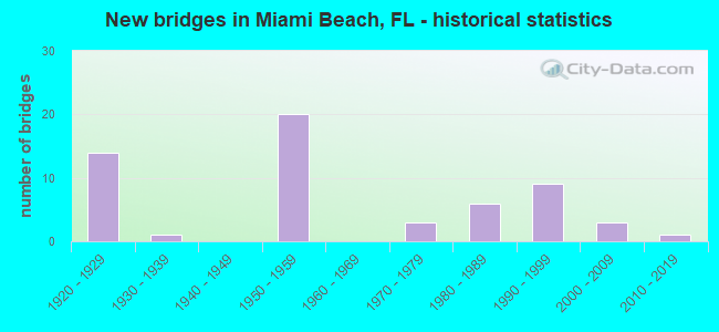
- New bridges - historical statistics
- 141920-1929
- 11930-1939
- 201950-1959
- 31970-1979
- 61980-1989
- 91990-1999
- 32000-2009
- 12010-2019

- Reconstructed bridges - Historical Statistics
- 11950-1959
- 01960-1969
- 01970-1979
- 21980-1989
- 11990-1999
- 32000-2009


- Bridge Condition - Deck
- 4.1%Very good
- 44.9%Good
- 24.5%Satisfactory
- 26.5%Fair

- Bridge Condition - Superstructure
- 2.0%Excellent
- 2.0%Very good
- 46.9%Good
- 22.4%Satisfactory
- 20.4%Fair
- 6.1%Poor

- Bridge Condition - Substructure
- 4.1%Very good
- 53.1%Good
- 28.6%Satisfactory
- 14.3%Fair

- Bridge Condition - Channel
- 4.3%Excellent
- 37.0%Very good
- 54.3%Good
- 4.3%Satisfactory
Find on map >> Show street view
Structure Number: 870054, Location: ARTHUR GODFREY RD MIA BCH (Lat: 25.813864, Lng: -80.132678), Route carried "on" structure: State highway 112, Year Built: 1956, Status: Open, Structure Length: 5.12m (16.80ft), Average Daily Traffic: 41,000 (year 2020), Truck Traffic: 5%, Average Future Daily Traffic: 71,135 (year 2042), Design Load: HS 20, Features Intersected: BISCAYNE WATERWAY
Minimum Vertical Clearance: 30+ m (98+ ft), Kilometerpoint: 0.312, Lanes on structure: 4, Owner: State Highway Agency, Approaching Roadway Width: 21.0m (68.9ft), Material/Design: Concrete, Design/Construction: Slab, Number Of Spans In Main Unit: 7, Length of Maximum Span: 7.3m (24.0ft), Curb or Sidewalk Widths: Left: 2.9m (9.5ft), Right: 4.3m (14.1ft), Curb-To-Curb Width: 17.2m (56.4ft), Out-to-Out Width: 26.4m (86.6ft)
Condition: Deck: Good, Superstructure: Good, Substructure: Good, Channel: Excellent, Operating Rating: 57.8 metric tons, Method Used To Determine Operating Rating: Load Factor (LF), Inventory Rating: 34.7 metric tons, Method Used To Determine Inventory Rating: Load Factor (LF), Structural Evaluation: Better than present minimum criteria, Deck Geometry: Somewhat better than minimum adequacy, Waterway Adequacy: Equal to present desirable criteria, Approach Roadway Alignment: Equal to present desirable criteria, Designated Inspection Frequency: Every 24 months, Underwater Inspection Frequency: Every 24 months, Inspection Date: Febuary 2021, Underwater Inspection Date: Febuary 2021, Deck Structure Type: Concrete Cast-file-Place, Wearing Surface/Protective System: Wearing Surface: Bituminous
Find on map >> Show street view
Structure Number: 870055, Location: ARTHUR GODFREY RD MIA BCH (Lat: 25.813417, Lng: -80.124583), Route carried "on" structure: State highway 112, Year Built: 1953, Status: Open, Structure Length: 8.50m (27.89ft), Average Daily Traffic: 41,000 (year 2020), Truck Traffic: 5%, Average Future Daily Traffic: 71,135 (year 2042), Design Load: HS 20, Features Intersected: INDIAN CREEK CANAL
Minimum Vertical Clearance: 30+ m (98+ ft), Kilometerpoint: 1.099, Lanes on structure: 5, Owner: State Highway Agency, Approaching Roadway Width: 24.0m (78.7ft), Material/Design: Steel, Design/Construction: Stringer/Multi-beam, Number Of Spans In Main Unit: 1, Number Of Approach Spans: 5, Length of Maximum Span: 15.9m (52.2ft), Curb or Sidewalk Widths: Left: 3.6m (11.8ft), Right: 3.5m (11.5ft), Curb-To-Curb Width: 18.3m (60.0ft), Out-to-Out Width: 26.0m (85.3ft)
Condition: Deck: Good, Superstructure: Good, Substructure: Good, Channel: Good, Operating Rating: 34.6 metric tons, Method Used To Determine Operating Rating: Load Factor (LF), Inventory Rating: 20.7 metric tons, Method Used To Determine Inventory Rating: Load Factor (LF), Structural Evaluation: Somewhat better than minimum adequacy, Deck Geometry: High priority of replacement, Waterway Adequacy: Superior to present desirable criteria, Approach Roadway Alignment: Equal to present minimum criteria, Length Of Structure Improvement: 0.74m (2.43ft), Designated Inspection Frequency: Every 24 months, Underwater Inspection Frequency: Every 24 months, Inspection Date: December 2020, Underwater Inspection Date: December 2020, Bridge Improvement Cost: $68,000, Total Project Cost: $68,000, Deck Structure Type: Concrete Cast-file-Place, Wearing Surface/Protective System: Wearing Surface: Bituminous
Find on map >> Show street view
Structure Number: 870077, Location: 1.5M E OF SR-5 (Lat: 25.773556, Lng: -80.144361), Route carried "on" structure: State highway A1A, Year Built: 1957, Status: Open, Structure Length: 65.68m (215.49ft), Average Daily Traffic: 67,000 (year 2020), Truck Traffic: 10%, Average Future Daily Traffic: 116,245 (year 2042), Design Load: HS 20, Features Intersected: EAST CHANNEL, Facility Carried by Structure: MACARTHUR EAST
Minimum Vertical Clearance: 30+ m (98+ ft), Kilometerpoint: 4.350, Lanes on structure: 6, Owner: State Highway Agency, Approaching Roadway Width: 24.0m (78.7ft), Skew: 30 degrees, Navigation Control: Yes ( Vertical Clearance: 10.7m (35.1ft), Horizontal Clearance: 22.9m (75.1ft)), Material/Design: Steel, Design/Construction: Stringer/Multi-beam, Number Of Spans In Main Unit: 3, Number Of Approach Spans: 34, Length of Maximum Span: 32.0m (105.0ft), Curb or Sidewalk Widths: Left: 2.2m (7.2ft), Right: 2.2m (7.2ft), Curb-To-Curb Width: 24.0m (78.7ft), Out-to-Out Width: 31.0m (101.7ft)
Condition: Deck: Satisfactory, Superstructure: Satisfactory, Substructure: Satisfactory, Channel: Good, Operating Rating: 54.4 metric tons, Method Used To Determine Operating Rating: Load Factor (LF), Inventory Rating: 32.7 metric tons, Method Used To Determine Inventory Rating: Load Factor (LF), Structural Evaluation: Equal to present minimum criteria, Deck Geometry: Somewhat better than minimum adequacy, Waterway Adequacy: Equal to present desirable criteria, Approach Roadway Alignment: Equal to present desirable criteria, Designated Inspection Frequency: Every 24 months, Underwater Inspection Frequency: Every 24 months, Inspection Date: October 2020, Underwater Inspection Date: October 2020, Deck Structure Type: Concrete Cast-file-Place
Find on map >> Show street view
Structure Number: 870099, Location: FLYOVER AT 5 ST MIA BEACH (Lat: 25.774722, Lng: -80.140789), Route carried "on" structure: Ramp State highway 907, Year Built: 1958, Status: Open, Structure Length: 22.34m (73.29ft), Average Daily Traffic: 14,500 (year 2020), Truck Traffic: 8%, Average Future Daily Traffic: 25,158 (year 2042), Design Load: HS 20, Features Intersected: SR-907 & 5 & 6 STREETS
Minimum Vertical Clearance: 30+ m (98+ ft), Kilometerpoint: 0.010, Lanes on structure: 1, Lanes under structure: 4, Owner: State Highway Agency, Approaching Roadway Width: 5.2m (17.1ft), Skew: 2 degrees, Material/Design: Concrete, Design/Construction: Slab, Number Of Spans In Main Unit: 18, Length of Maximum Span: 18.9m (62.0ft), Curb-To-Curb Width: 5.2m (17.1ft), Out-to-Out Width: 6.1m (20.0ft)
Condition: Deck: Good, Superstructure: Good, Substructure: Good, Operating Rating: 63.4 metric tons, Method Used To Determine Operating Rating: Load Factor (LF), Inventory Rating: 38.0 metric tons, Method Used To Determine Inventory Rating: Load Factor (LF), Structural Evaluation: Better than present minimum criteria, Deck Geometry: High priority of corrective action, Underclear: High priority of corrective action, Approach Roadway Alignment: Somewhat better than minimum adequacy, Length Of Structure Improvement: 6.64m (21.78ft), Designated Inspection Frequency: Every 24 months, Inspection Date: July 2020, Bridge Improvement Cost: $767,000, Total Project Cost: $767,000, Deck Structure Type: Concrete Cast-file-Place, Wearing Surface/Protective System: Wearing Surface: Monolithic Concrete
Find on map >> Show street view
Structure Number: 870302, Location: 2.4 Miles E of US-1 (Lat: 25.810528, Lng: -80.148667), Route carried "on" structure: Spur Interstate 195, Year Built: 1959, Year Reconstructed: 1991, Status: Open, Structure Length: 34.69m (113.81ft), Average Daily Traffic: 68,000 (year 2021), Truck Traffic: 5%, Average Future Daily Traffic: 117,980 (year 2041), Design Load: HS 20, Features Intersected: BISCAYNE BAY
Minimum Vertical Clearance: 30+ m (98+ ft), Kilometerpoint: 6.373, Lanes on structure: 6, Base Highway Network: Yes, Owner: State Highway Agency, Approaching Roadway Width: 34.1m (111.9ft), Skew: 30 degrees, Navigation Control: Yes ( Vertical Clearance: 11.0m (36.1ft), Horizontal Clearance: 28.0m (91.9ft)), Material/Design: Prestressed concrete, Design/Construction: Stringer/Multi-beam, Number Of Spans In Main Unit: 17, Length of Maximum Span: 29.9m (98.1ft), Curb-To-Curb Width: 34.1m (111.9ft), Out-to-Out Width: 38.4m (126.0ft)
Condition: Deck: Satisfactory, Superstructure: Satisfactory, Substructure: Satisfactory, Channel: Good, Operating Rating: 65.0 metric tons, Method Used To Determine Operating Rating: Load Factor (LF), Inventory Rating: 38.9 metric tons, Method Used To Determine Inventory Rating: Load Factor (LF), Structural Evaluation: Equal to present minimum criteria, Deck Geometry: Superior to present desirable criteria, Waterway Adequacy: Better than present minimum criteria, Approach Roadway Alignment: Equal to present desirable criteria, Designated Inspection Frequency: Every 24 months, Underwater Inspection Frequency: Every 24 months, Inspection Date: October 2021, Underwater Inspection Date: October 2021, Total Project Cost: $292,000, Deck Structure Type: Concrete Cast-file-Place
Find on map >> Show street view
Structure Number: 870303, Location: I-195 OVER ALTON RD (Lat: 25.812000, Lng: -80.138167), Route carried "on" structure: Spur Interstate 195, Year Built: 1959, Year Reconstructed: 1990, Status: Open, Structure Length: 9.45m (31.00ft), Average Daily Traffic: 68,000 (year 2020), Truck Traffic: 5%, Average Future Daily Traffic: 117,980 (year 2042), Design Load: HS 20, Features Intersected: ALTON ROAD
Minimum Vertical Clearance: 30+ m (98+ ft), Kilometerpoint: 7.612, Lanes on structure: 5, Lanes under structure: 5, Base Highway Network: Yes, Owner: State Highway Agency, Approaching Roadway Width: 29.1m (95.5ft), Skew: 39 degrees, Material/Design: Prestressed concrete, Design/Construction: Stringer/Multi-beam, Number Of Spans In Main Unit: 7, Length of Maximum Span: 14.6m (47.9ft), Curb-To-Curb Width: 30.3m (99.4ft), Out-to-Out Width: 31.9m (104.7ft)
Condition: Deck: Satisfactory, Superstructure: Satisfactory, Substructure: Good, Operating Rating: 69.3 metric tons, Method Used To Determine Operating Rating: Load Factor (LF), Inventory Rating: 41.6 metric tons, Method Used To Determine Inventory Rating: Load Factor (LF), Structural Evaluation: Equal to present minimum criteria, Deck Geometry: Superior to present desirable criteria, Underclear: High priority of corrective action, Approach Roadway Alignment: Equal to present desirable criteria, Designated Inspection Frequency: Every 24 months, Inspection Date: Febuary 2021, Deck Structure Type: Concrete Cast-file-Place
Find on map >> Show street view
Structure Number: 870377, Location: RAMP OFF JULIA TUTTLE (Lat: 25.811111, Lng: -80.137508), Route carried "on" structure: Ramp Interstate 195, Year Built: 1959, Year Reconstructed: 1991, Status: Open, Structure Length: 3.87m (12.70ft), Average Daily Traffic: 16,500 (year 2021), Truck Traffic: 8%, Average Future Daily Traffic: 28,628 (year 2041), Design Load: HS 20, Features Intersected: NORTHBOUND ALTON ROAD
Minimum Vertical Clearance: 30+ m (98+ ft), Kilometerpoint: 0.142, Lanes on structure: 1, Lanes under structure: 1, Owner: State Highway Agency, Approaching Roadway Width: 10.1m (33.1ft), Skew: 2 degrees, Material/Design: Prestressed concrete, Design/Construction: Stringer/Multi-beam, Number Of Spans In Main Unit: 3, Length of Maximum Span: 14.6m (47.9ft), Curb-To-Curb Width: 9.1m (29.9ft), Out-to-Out Width: 10.4m (34.1ft)
Condition: Deck: Satisfactory, Superstructure: Good, Substructure: Good, Operating Rating: 44.9 metric tons, Method Used To Determine Operating Rating: Load Factor (LF), Inventory Rating: 26.9 metric tons, Method Used To Determine Inventory Rating: Load Factor (LF), Structural Evaluation: Equal to present minimum criteria, Deck Geometry: Superior to present desirable criteria, Underclear: High priority of corrective action, Approach Roadway Alignment: Meets minimum limits, Designated Inspection Frequency: Every 24 months, Inspection Date: October 2021, Deck Structure Type: Concrete Cast-file-Place
Find on map >> Show street view
Structure Number: 870551, Location: NE 79th St & Biscayne Bay (Lat: 25.849597, Lng: -80.144650), Route carried "on" structure: State highway 934, Year Built: 1973, Status: Open, Structure Length: 31.35m (102.85ft), Average Daily Traffic: 20,500 (year 2018), Truck Traffic: 5%, Average Future Daily Traffic: 35,568 (year 2040), Design Load: HS 20, Features Intersected: East Biscayne Bay
Minimum Vertical Clearance: 30+ m (98+ ft), Kilometerpoint: 3.940, Lanes on structure: 3, Owner: State Highway Agency, Approaching Roadway Width: 12.2m (40.0ft), Navigation Control: Yes ( Vertical Clearance: 6.4m (21.0ft), Horizontal Clearance: 18.3m (60.0ft)), Material/Design: Steel, Design/Construction: Movable - Bascule, Number Of Spans In Main Unit: 1, Number Of Approach Spans: 16, Length of Maximum Span: 27.4m (89.9ft), Curb or Sidewalk Widths: Left: 0.6m (2.0ft), Right: 1.2m (3.9ft), Curb-To-Curb Width: 12.2m (40.0ft), Out-to-Out Width: 14.7m (48.2ft)
Condition: Deck: Good, Superstructure: Good, Substructure: Fair, Channel: Very good, Operating Rating: 41.7 metric tons, Method Used To Determine Operating Rating: Load Factor (LF), Inventory Rating: 24.9 metric tons, Method Used To Determine Inventory Rating: Load Factor (LF), Structural Evaluation: Somewhat better than minimum adequacy, Deck Geometry: Meets minimum limits, Waterway Adequacy: Equal to present desirable criteria, Approach Roadway Alignment: Equal to present desirable criteria, Designated Inspection Frequency: Every 24 months, Critical Feature Inspection Frequency: Every 24 months, Underwater Inspection Frequency: Every 24 months, Other Special Inspection Frequency: Every 12 months, Inspection Date: Febuary 2021, Critical Feature Inspection Date: Febuary 2021, Underwater Inspection Date: Febuary 2021, Other Special Inspection Date: Febuary 2021, Deck Structure Type: Concrete Cast-file-Place, Wearing Surface/Protective System: Wearing Surface: Monolithic Concrete
Find on map >> Show street view
Structure Number: 870613, Location: 500 ft W of SR-A1A (Lat: 25.844350, Lng: -80.122314), Route carried "on" structure: Business State highway 907, Year Built: 1953, Year Reconstructed: 2009, Status: Open, Structure Length: 9.72m (31.89ft), Average Daily Traffic: 37,500 (year 2018), Truck Traffic: 3%, Average Future Daily Traffic: 65,062 (year 2040), Design Load: HS 20, Features Intersected: Indian Creek Canal, Facility Carried by Structure: 63 St.
Minimum Vertical Clearance: 30+ m (98+ ft), Kilometerpoint: 8.890, Lanes on structure: 6, Owner: State Highway Agency, Approaching Roadway Width: 24.3m (79.7ft), Navigation Control: Yes ( Vertical Clearance: 2.4m (7.9ft), Horizontal Clearance: 15.2m (49.9ft)), Material/Design: Steel, Design/Construction: Movable - Bascule, Number Of Spans In Main Unit: 1, Number Of Approach Spans: 8, Length of Maximum Span: 22.7m (74.5ft), Curb or Sidewalk Widths: Left: 1.7m (5.6ft), Right: 1.7m (5.6ft), Curb-To-Curb Width: 21.0m (68.9ft), Out-to-Out Width: 24.4m (80.1ft)
Condition: Deck: Good, Superstructure: Good, Substructure: Good, Channel: Very good, Operating Rating: 39.8 metric tons, Method Used To Determine Operating Rating: Load Factor (LF), Inventory Rating: 23.9 metric tons, Method Used To Determine Inventory Rating: Load Factor (LF), Structural Evaluation: Somewhat better than minimum adequacy, Deck Geometry: High priority of replacement, Waterway Adequacy: Better than present minimum criteria, Approach Roadway Alignment: Equal to present minimum criteria, Designated Inspection Frequency: Every 24 months, Critical Feature Inspection Frequency: Every 24 months, Underwater Inspection Frequency: Every 24 months, Other Special Inspection Frequency: Every 12 months, Inspection Date: April 2021, Critical Feature Inspection Date: April 2021, Underwater Inspection Date: April 2021, Other Special Inspection Date: April 2021, Deck Structure Type: Concrete Cast-file-Place, Wearing Surface/Protective System: Wearing Surface: Other
Find on map >> Show street view
Structure Number: 870665, Location: .06M N OF 17 ST MIAMI BCH (Lat: 25.793158, Lng: -80.141317), Route carried "on" structure: State highway 907, Year Built: 1956, Year Reconstructed: 1962, Status: Open, Structure Length: 1.74m (5.71ft), Average Daily Traffic: 27,500 (year 2020), Truck Traffic: 6%, Average Future Daily Traffic: 47,712 (year 2042), Design Load: HS 20, Features Intersected: COLLINS CANAL
Minimum Vertical Clearance: 30+ m (98+ ft), Kilometerpoint: 2.078, Lanes on structure: 5, Owner: State Highway Agency, Approaching Roadway Width: 24.4m (80.1ft), Skew: 3 degrees, Material/Design: Concrete, Design/Construction: Arch - Deck, Number Of Spans In Main Unit: 1, Length of Maximum Span: 17.4m (57.1ft), Curb or Sidewalk Widths: Left: 2.3m (7.5ft), Right: 2.1m (6.9ft), Curb-To-Curb Width: 24.4m (80.1ft), Out-to-Out Width: 31.6m (103.7ft)
Condition: Deck: Good, Superstructure: Good, Substructure: Good, Channel: Good, Operating Rating: 63.2 metric tons, Method Used To Determine Operating Rating: Load Factor (LF), Inventory Rating: 37.9 metric tons, Method Used To Determine Inventory Rating: Load Factor (LF), Structural Evaluation: Better than present minimum criteria, Deck Geometry: Superior to present desirable criteria, Waterway Adequacy: Meets minimum limits, Approach Roadway Alignment: Equal to present minimum criteria, Designated Inspection Frequency: Every 24 months, Underwater Inspection Frequency: Every 24 months, Inspection Date: March 2021, Underwater Inspection Date: March 2021, Deck Structure Type: Concrete Cast-file-Place, Wearing Surface/Protective System: Wearing Surface: Bituminous
Find on map >> Show street view
Structure Number: 87067, Location: 63 ST MIAMI BEACH (Lat: 25.844019, Lng: -80.124556), Route carried "on" structure: State highway 907, Year Built: 1951, Status: Open, Structure Length: 7.56m (24.80ft), Average Daily Traffic: 34,000 (year 2020), Truck Traffic: 3%, Average Future Daily Traffic: 58,990 (year 2042), Design Load: HS 20, Features Intersected: INDIAN CREEK CANAL West
Minimum Vertical Clearance: 30+ m (98+ ft), Kilometerpoint: 8.666, Lanes on structure: 6, Owner: State Highway Agency, Approaching Roadway Width: 20.1m (65.9ft), Material/Design: Concrete, Design/Construction: Slab, Number Of Spans In Main Unit: 10, Length of Maximum Span: 7.6m (24.9ft), Curb or Sidewalk Widths: Left: 1.8m (5.9ft), Right: 1.8m (5.9ft), Curb-To-Curb Width: 20.1m (65.9ft), Out-to-Out Width: 24.4m (80.1ft)
Condition: Deck: Good, Superstructure: Good, Substructure: Good, Channel: Very good, Operating Rating: 62.1 metric tons, Method Used To Determine Operating Rating: Load Factor (LF), Inventory Rating: 37.3 metric tons, Method Used To Determine Inventory Rating: Load Factor (LF), Structural Evaluation: Better than present minimum criteria, Deck Geometry: High priority of replacement, Waterway Adequacy: Equal to present desirable criteria, Approach Roadway Alignment: Better than present minimum criteria, Designated Inspection Frequency: Every 24 months, Underwater Inspection Frequency: Every 24 months, Inspection Date: July 2021, Underwater Inspection Date: July 2021, Deck Structure Type: Concrete Precast Panels, Wearing Surface/Protective System: Wearing Surface: Bituminous
Find on map >> Show street view
Structure Number: 870771, Location: INTRACOASTAL WATERWAY (Lat: 25.787464, Lng: -80.182086), Route carried "on" structure: State highway A1A, Year Built: 1996, Year Reconstructed: 2013, Status: Open, Structure Length: 75.22m (246.78ft), Average Daily Traffic: 29,500 (year 2021), Truck Traffic: 4%, Average Future Daily Traffic: 51,182 (year 2041), Design Load: HL 93, Features Intersected: INTRACOASTAL WATERWAY
Minimum Vertical Clearance: 30.45m (99.90ft), Kilometerpoint: 0.000, Lanes on structure: 4, Lanes under structure: 2, Base Highway Network: Yes, Owner: State Highway Agency, Approaching Roadway Width: 21.3m (69.9ft), Navigation Control: Yes ( Vertical Clearance: 19.8m (65.0ft), Horizontal Clearance: 27.4m (89.9ft)), Material/Design: Prestressed concrete continuous, Design/Construction: Stringer/Multi-beam, Number Of Spans In Main Unit: 18, Length of Maximum Span: 44.2m (145.0ft), Curb or Sidewalk Widths: Left: 1.8m (5.9ft), Right: 0.0m, Curb-To-Curb Width: 21.3m (69.9ft), Out-to-Out Width: 24.3m (79.7ft)
Condition: Deck: Satisfactory, Superstructure: Good, Substructure: Good, Channel: Good, Operating Rating: 44.5 metric tons, Method Used To Determine Operating Rating: Load and Resistance Factor (LRFR), Inventory Rating: 34.3 metric tons, Method Used To Determine Inventory Rating: Load and Resistance Factor (LRFR), Structural Evaluation: Better than present minimum criteria, Deck Geometry: High priority of corrective action, Waterway Adequacy: Superior to present desirable criteria, Approach Roadway Alignment: Equal to present desirable criteria, Designated Inspection Frequency: Every 24 months, Underwater Inspection Frequency: Every 24 months, Inspection Date: December 2021, Underwater Inspection Date: December 2021, Deck Structure Type: Concrete Cast-file-Place
Find on map >> Show street view
Structure Number: 870772, Location: INTRACOASTAL WATERWAY (Lat: 25.787147, Lng: -80.181367), Route carried "on" structure: State highway A1A, Year Built: 1995, Year Reconstructed: 2013, Status: Open, Structure Length: 74.80m (245.41ft), Average Daily Traffic: 29,500 (year 2021), Truck Traffic: 4%, Average Future Daily Traffic: 51,182 (year 2041), Design Load: HL 93, Features Intersected: INTRACOASTAL WATERWAY
Minimum Vertical Clearance: 5.36m (17.59ft), Kilometerpoint: 0.000, Lanes on structure: 4, Lanes under structure: 2, Base Highway Network: Yes, Owner: State Highway Agency, Approaching Roadway Width: 21.0m (68.9ft), Navigation Control: Yes ( Vertical Clearance: 19.8m (65.0ft), Horizontal Clearance: 27.4m (89.9ft)), Material/Design: Prestressed concrete continuous, Design/Construction: Stringer/Multi-beam, Number Of Spans In Main Unit: 18, Length of Maximum Span: 44.2m (145.0ft), Curb or Sidewalk Widths: Left: 0.0m, Right: 1.8m (5.9ft), Curb-To-Curb Width: 21.0m (68.9ft), Out-to-Out Width: 23.9m (78.4ft)
Condition: Deck: Satisfactory, Superstructure: Good, Substructure: Good, Channel: Good, Operating Rating: 49.4 metric tons, Method Used To Determine Operating Rating: Load and Resistance Factor (LRFR), Inventory Rating: 37.2 metric tons, Method Used To Determine Inventory Rating: Load and Resistance Factor (LRFR), Structural Evaluation: Better than present minimum criteria, Deck Geometry: Superior to present desirable criteria, Waterway Adequacy: Equal to present minimum criteria, Approach Roadway Alignment: Equal to present desirable criteria, Designated Inspection Frequency: Every 24 months, Underwater Inspection Frequency: Every 24 months, Inspection Date: December 2021, Underwater Inspection Date: December 2021, Deck Structure Type: Concrete Cast-file-Place
Find on map >> Show street view
Structure Number: 870788, Location: 250 Ft. S of W 23rd St. (Lat: 25.803497, Lng: -80.145083), Route carried "on" structure: City street , Year Built: 1995, Status: Open, Structure Length: 7.44m (24.41ft), Average Daily Traffic: 728 (year 2020), Truck Traffic: 2%, Average Future Daily Traffic: 816 (year 2042), Design Load: HS 20, Features Intersected: Sunset Lake Canal, Facility Carried by Structure: Sunset Drive
Minimum Vertical Clearance: 30+ m (98+ ft), Kilometerpoint: 0.074, Lanes on structure: 2, Owner: City or Municipal Highway Agency, Approaching Roadway Width: 7.8m (25.6ft), Material/Design: Concrete continuous, Design/Construction: Slab, Number Of Spans In Main Unit: 7, Length of Maximum Span: 10.7m (35.1ft), Curb or Sidewalk Widths: Left: 0.0m, Right: 2.0m (6.6ft), Curb-To-Curb Width: 9.0m (29.5ft), Out-to-Out Width: 12.2m (40.0ft)
Condition: Deck: Good, Superstructure: Good, Substructure: Good, Channel: Very good, Operating Rating: 76.7 metric tons, Method Used To Determine Operating Rating: Load Factor (LF), Inventory Rating: 45.9 metric tons, Method Used To Determine Inventory Rating: Load Factor (LF), Structural Evaluation: Better than present minimum criteria, Deck Geometry: Somewhat better than minimum adequacy, Waterway Adequacy: Better than present minimum criteria, Approach Roadway Alignment: Equal to present minimum criteria, Designated Inspection Frequency: Every 24 months, Underwater Inspection Frequency: Every 24 months, Inspection Date: September 2021, Underwater Inspection Date: September 2021, Deck Structure Type: Concrete Cast-file-Place, Wearing Surface/Protective System: Wearing Surface: Monolithic Concrete
Find on map >> Show street view
Structure Number: 87079, Location: 300 ft E/O Meridian Ave (Lat: 25.821867, Lng: -80.130367), Route carried "on" structure: City street , Year Built: 1996, Status: Open, Structure Length: 5.06m (16.60ft), Average Daily Traffic: 4,838 (year 2020), Truck Traffic: 2%, Average Future Daily Traffic: 5,066 (year 2042), Design Load: HS 20, Features Intersected: Biscayne Waterway, Facility Carried by Structure: West 47th Street
Minimum Vertical Clearance: 30+ m (98+ ft), Kilometerpoint: 0.509, Lanes on structure: 2, Owner: City or Municipal Highway Agency, Approaching Roadway Width: 9.4m (30.8ft), Navigation Control: Yes ( Vertical Clearance: 3.0m (9.8ft), Horizontal Clearance: 8.8m (28.9ft)), Material/Design: Prestressed concrete, Design/Construction: Slab, Number Of Spans In Main Unit: 5, Length of Maximum Span: 10.2m (33.5ft), Curb or Sidewalk Widths: Left: 2.0m (6.6ft), Right: 2.0m (6.6ft), Curb-To-Curb Width: 9.4m (30.8ft), Out-to-Out Width: 14.0m (45.9ft)
Condition: Deck: Very good, Superstructure: Very good, Substructure: Satisfactory, Channel: Very good, Operating Rating: 86.2 metric tons, Method Used To Determine Operating Rating: Load Factor (LF), Inventory Rating: 51.6 metric tons, Method Used To Determine Inventory Rating: Load Factor (LF), Structural Evaluation: Equal to present minimum criteria, Deck Geometry: Meets minimum limits, Waterway Adequacy: Equal to present desirable criteria, Approach Roadway Alignment: Equal to present desirable criteria, Designated Inspection Frequency: Every 24 months, Underwater Inspection Frequency: Every 24 months, Inspection Date: October 2020, Underwater Inspection Date: October 2020, Deck Structure Type: Concrete Precast Panels, Wearing Surface/Protective System: Wearing Surface: Bituminous
Find on map >> Show street view
Structure Number: 87446, Location: 1.0 Mile EAST of US-1 (Lat: 25.790331, Lng: -80.171347), Route carried "on" structure: County highway , Year Built: 1927, Status: Posted for load, Structure Length: 6.28m (20.60ft), Average Daily Traffic: 8,323 (year 2021), Truck Traffic: 2%, Average Future Daily Traffic: 14,158 (year 2042), Design Load: HS 15, Features Intersected: Biscayne Bay, Facility Carried by Structure: Venetian Causeway
Minimum Vertical Clearance: 30+ m (98+ ft), Kilometerpoint: 1.764, Lanes on structure: 2, Toll: On toll road, Owner: County Highway Agency, Approaching Roadway Width: 9.8m (32.2ft), Material/Design: Concrete continuous, Design/Construction: Tee Beam, Number Of Spans In Main Unit: 4, Length of Maximum Span: 16.4m (53.8ft), Curb or Sidewalk Widths: Left: 1.2m (3.9ft), Right: 1.2m (3.9ft), Curb-To-Curb Width: 9.8m (32.2ft), Out-to-Out Width: 12.7m (41.7ft)
Condition: Deck: Fair, Superstructure: Fair, Substructure: Satisfactory, Channel: Very good, Operating Rating: 12.4 metric tons, Method Used To Determine Operating Rating: Load Factor (LF), Inventory Rating: 7.4 metric tons, Method Used To Determine Inventory Rating: Load Factor (LF), Structural Evaluation: High priority of corrective action, Deck Geometry: Meets minimum limits, Waterway Adequacy: Meets minimum limits, Approach Roadway Alignment: Equal to present desirable criteria, Bridge Posting: Required (Relationship of Operating Rating to Maximum Legal Load: > 39.9% below), Designated Inspection Frequency: Every 24 months, Underwater Inspection Frequency: Every 24 months, Other Special Inspection Frequency: Every 12 months, Inspection Date: October 2021, Underwater Inspection Date: October 2021, Other Special Inspection Date: October 2021, Deck Structure Type: Concrete Cast-file-Place, Wearing Surface/Protective System: Wearing Surface: Bituminous
Find on map >> Show street view
Structure Number: 874461, Location: 1.4 Miles EAST of US-1 (Lat: 25.790611, Lng: -80.165611), Route carried "on" structure: County highway , Year Built: 1927, Status: Posted for load, Structure Length: 5.04m (16.54ft), Average Daily Traffic: 8,323 (year 2014), Truck Traffic: 2%, Average Future Daily Traffic: 14,158 (year 2039), Design Load: H 15, Features Intersected: Biscayne Bay, Facility Carried by Structure: Venetian Way
Minimum Vertical Clearance: 30+ m (98+ ft), Kilometerpoint: 2.350, Lanes on structure: 2, Toll: On toll road, Owner: County Highway Agency, Approaching Roadway Width: 9.8m (32.2ft), Material/Design: Concrete continuous, Design/Construction: Tee Beam, Number Of Spans In Main Unit: 3, Length of Maximum Span: 18.2m (59.7ft), Curb or Sidewalk Widths: Left: 1.2m (3.9ft), Right: 1.2m (3.9ft), Curb-To-Curb Width: 9.8m (32.2ft), Out-to-Out Width: 12.8m (42.0ft)
Condition: Deck: Fair, Superstructure: Poor, Substructure: Fair, Channel: Good, Operating Rating: 7.7 metric tons, Method Used To Determine Operating Rating: Load Factor (LF), Inventory Rating: 4.4 metric tons, Method Used To Determine Inventory Rating: Load Factor (LF), Structural Evaluation: High priority of corrective action, Deck Geometry: Meets minimum limits, Waterway Adequacy: Meets minimum limits, Approach Roadway Alignment: Equal to present desirable criteria, Bridge Posting: Required (Relationship of Operating Rating to Maximum Legal Load: > 39.9% below), Designated Inspection Frequency: Every 24 months, Underwater Inspection Frequency: Every 24 months, Other Special Inspection Frequency: Every 12 months, Inspection Date: September 2021, Underwater Inspection Date: September 2021, Other Special Inspection Date: September 2021, Deck Structure Type: Concrete Cast-file-Place, Wearing Surface/Protective System: Wearing Surface: Bituminous
Find on map >> Show street view
Structure Number: 874463, Location: 1.5 Miles EAST of US-1 (Lat: 25.790667, Lng: -80.164278), Route carried "on" structure: County highway , Year Built: 1927, Status: Posted for load, Structure Length: 4.88m (16.01ft), Average Daily Traffic: 8,320 (year 2021), Truck Traffic: 2%, Average Future Daily Traffic: 14,160 (year 2042), Design Load: H 15, Features Intersected: Biscayne Bay, Facility Carried by Structure: Venetian Way
Minimum Vertical Clearance: 30+ m (98+ ft), Kilometerpoint: 2.478, Lanes on structure: 2, Toll: On toll road, Owner: County Highway Agency, Approaching Roadway Width: 9.8m (32.2ft), Material/Design: Concrete continuous, Design/Construction: Tee Beam, Number Of Spans In Main Unit: 3, Length of Maximum Span: 18.1m (59.4ft), Curb or Sidewalk Widths: Left: 1.2m (3.9ft), Right: 1.2m (3.9ft), Curb-To-Curb Width: 9.8m (32.2ft), Out-to-Out Width: 12.8m (42.0ft)
Condition: Deck: Satisfactory, Superstructure: Fair, Substructure: Satisfactory, Channel: Very good, Operating Rating: 8.9 metric tons, Method Used To Determine Operating Rating: Load Factor (LF), Inventory Rating: 4.9 metric tons, Method Used To Determine Inventory Rating: Load Factor (LF), Structural Evaluation: High priority of corrective action, Deck Geometry: Meets minimum limits, Waterway Adequacy: Meets minimum limits, Approach Roadway Alignment: Equal to present desirable criteria, Bridge Posting: Required (Relationship of Operating Rating to Maximum Legal Load: > 39.9% below), Designated Inspection Frequency: Every 24 months, Underwater Inspection Frequency: Every 24 months, Other Special Inspection Frequency: Every 12 months, Inspection Date: October 2021, Underwater Inspection Date: October 2021, Other Special Inspection Date: October 2021, Deck Structure Type: Concrete Cast-file-Place, Wearing Surface/Protective System: Wearing Surface: Bituminous
Find on map >> Show street view
Structure Number: 874465, Location: 1.7 Miles EAST of US-1 (Lat: 25.790789, Lng: -80.161647), Route carried "on" structure: County highway , Year Built: 1927, Status: Posted for load, Structure Length: 5.03m (16.50ft), Average Daily Traffic: 8,323 (year 2021), Truck Traffic: 2%, Average Future Daily Traffic: 14,158 (year 2042), Design Load: H 15, Features Intersected: Biscayne Bay, Facility Carried by Structure: Venetian Causeway
Minimum Vertical Clearance: 30+ m (98+ ft), Kilometerpoint: 2.744, Lanes on structure: 2, Toll: On toll road, Owner: County Highway Agency, Approaching Roadway Width: 9.8m (32.2ft), Material/Design: Concrete continuous, Design/Construction: Tee Beam, Number Of Spans In Main Unit: 3, Length of Maximum Span: 18.1m (59.4ft), Curb or Sidewalk Widths: Left: 1.2m (3.9ft), Right: 1.2m (3.9ft), Curb-To-Curb Width: 9.8m (32.2ft), Out-to-Out Width: 12.7m (41.7ft)
Condition: Deck: Fair, Superstructure: Poor, Substructure: Satisfactory, Channel: Very good, Operating Rating: 7.6 metric tons, Method Used To Determine Operating Rating: Load Factor (LF), Inventory Rating: 4.1 metric tons, Method Used To Determine Inventory Rating: Load Factor (LF), Structural Evaluation: High priority of corrective action, Deck Geometry: Meets minimum limits, Waterway Adequacy: Meets minimum limits, Approach Roadway Alignment: Equal to present desirable criteria, Bridge Posting: Required (Relationship of Operating Rating to Maximum Legal Load: > 39.9% below), Designated Inspection Frequency: Every 24 months, Underwater Inspection Frequency: Every 24 months, Other Special Inspection Frequency: Every 12 months, Inspection Date: October 2021, Underwater Inspection Date: October 2021, Other Special Inspection Date: October 2021, Deck Structure Type: Concrete Cast-file-Place, Wearing Surface/Protective System: Wearing Surface: Bituminous
Find on map >> Show street view
Structure Number: 874471, Location: 1.9 Miles EAST of US-1 (Lat: 25.790969, Lng: -80.157664), Route carried "on" structure: City street , Year Built: 1927, Status: Posted for load, Structure Length: 5.04m (16.54ft), Average Daily Traffic: 8,323 (year 2021), Truck Traffic: 2%, Average Future Daily Traffic: 14,158 (year 2042), Design Load: H 15, Features Intersected: Biscayne Bay, Facility Carried by Structure: Venetian Causeway
Minimum Vertical Clearance: 30+ m (98+ ft), Kilometerpoint: 3.141, Lanes on structure: 2, Toll: On toll road, Owner: County Highway Agency, Approaching Roadway Width: 9.8m (32.2ft), Material/Design: Concrete continuous, Design/Construction: Tee Beam, Number Of Spans In Main Unit: 3, Length of Maximum Span: 18.2m (59.7ft), Curb or Sidewalk Widths: Left: 1.2m (3.9ft), Right: 1.2m (3.9ft), Curb-To-Curb Width: 9.8m (32.2ft), Out-to-Out Width: 12.7m (41.7ft)
Condition: Deck: Fair, Superstructure: Fair, Substructure: Satisfactory, Channel: Good, Operating Rating: 7.3 metric tons, Method Used To Determine Operating Rating: Load Factor (LF), Inventory Rating: 4.1 metric tons, Method Used To Determine Inventory Rating: Load Factor (LF), Structural Evaluation: High priority of corrective action, Deck Geometry: Meets minimum limits, Waterway Adequacy: Meets minimum limits, Approach Roadway Alignment: Equal to present desirable criteria, Bridge Posting: Required (Relationship of Operating Rating to Maximum Legal Load: > 39.9% below), Designated Inspection Frequency: Every 24 months, Underwater Inspection Frequency: Every 24 months, Other Special Inspection Frequency: Every 12 months, Inspection Date: November 2021, Underwater Inspection Date: November 2021, Other Special Inspection Date: November 2021, Deck Structure Type: Concrete Cast-file-Place, Wearing Surface/Protective System: Wearing Surface: Bituminous
Find on map >> Show street view
Structure Number: 874472, Location: 2.0 Miles E of US 1 (Lat: 25.791058, Lng: -80.156417), Route carried "on" structure: City street , Year Built: 1927, Status: Posted for load, Structure Length: 5.03m (16.50ft), Average Daily Traffic: 8,323 (year 2021), Truck Traffic: 2%, Average Future Daily Traffic: 14,158 (year 2042), Design Load: H 15, Features Intersected: Biscayne Bay, Facility Carried by Structure: Venetian Cswy
Minimum Vertical Clearance: 30+ m (98+ ft), Kilometerpoint: 3.270, Lanes on structure: 2, Toll: On toll road, Owner: County Highway Agency, Approaching Roadway Width: 9.8m (32.2ft), Material/Design: Concrete continuous, Design/Construction: Tee Beam, Number Of Spans In Main Unit: 3, Length of Maximum Span: 18.2m (59.7ft), Curb or Sidewalk Widths: Left: 1.2m (3.9ft), Right: 1.2m (3.9ft), Curb-To-Curb Width: 9.8m (32.2ft), Out-to-Out Width: 12.7m (41.7ft)
Condition: Deck: Fair, Superstructure: Fair, Substructure: Satisfactory, Channel: Good, Operating Rating: 7.3 metric tons, Method Used To Determine Operating Rating: Load Factor (LF), Inventory Rating: 4.1 metric tons, Method Used To Determine Inventory Rating: Load Factor (LF), Structural Evaluation: High priority of corrective action, Deck Geometry: Meets minimum limits, Waterway Adequacy: Meets minimum limits, Approach Roadway Alignment: Equal to present desirable criteria, Bridge Posting: Required (Relationship of Operating Rating to Maximum Legal Load: > 39.9% below), Designated Inspection Frequency: Every 24 months, Underwater Inspection Frequency: Every 24 months, Other Special Inspection Frequency: Every 12 months, Inspection Date: November 2021, Underwater Inspection Date: November 2021, Other Special Inspection Date: November 2021, Deck Structure Type: Concrete Cast-file-Place, Wearing Surface/Protective System: Wearing Surface: Bituminous
Find on map >> Show street view
Structure Number: 874473, Location: 2.1 Miles East of US-1 (Lat: 25.791167, Lng: -80.153750), Route carried "on" structure: City street , Year Built: 1927, Status: Posted for load, Structure Length: 4.67m (15.32ft), Average Daily Traffic: 8,323 (year 2021), Truck Traffic: 2%, Average Future Daily Traffic: 14,158 (year 2042), Design Load: H 15, Features Intersected: Biscayne Bay, Facility Carried by Structure: Venetian Causeway
Minimum Vertical Clearance: 30+ m (98+ ft), Kilometerpoint: 3.536, Lanes on structure: 2, Toll: On toll road, Owner: County Highway Agency, Approaching Roadway Width: 9.8m (32.2ft), Material/Design: Concrete continuous, Design/Construction: Tee Beam, Number Of Spans In Main Unit: 3, Length of Maximum Span: 16.8m (55.1ft), Curb or Sidewalk Widths: Left: 1.2m (3.9ft), Right: 1.2m (3.9ft), Curb-To-Curb Width: 9.8m (32.2ft), Out-to-Out Width: 12.7m (41.7ft)
Condition: Deck: Fair, Superstructure: Fair, Substructure: Satisfactory, Channel: Good, Operating Rating: 7.3 metric tons, Method Used To Determine Operating Rating: Load Factor (LF), Inventory Rating: 4.1 metric tons, Method Used To Determine Inventory Rating: Load Factor (LF), Structural Evaluation: High priority of corrective action, Deck Geometry: Meets minimum limits, Waterway Adequacy: Meets minimum limits, Approach Roadway Alignment: Equal to present desirable criteria, Bridge Posting: Required (Relationship of Operating Rating to Maximum Legal Load: > 39.9% below), Designated Inspection Frequency: Every 24 months, Underwater Inspection Frequency: Every 24 months, Other Special Inspection Frequency: Every 12 months, Inspection Date: November 2021, Underwater Inspection Date: November 2021, Other Special Inspection Date: November 2021, Deck Structure Type: Concrete Cast-file-Place, Wearing Surface/Protective System: Wearing Surface: Bituminous
Find on map >> Show street view
Structure Number: 874474, Location: Rivo Alto to Belle Isle (Lat: 25.791250, Lng: -80.152167), Route carried "on" structure: County highway , Year Built: 1927, Status: Posted for load, Structure Length: 9.27m (30.41ft), Average Daily Traffic: 20,400 (year 2021), Truck Traffic: 5%, Average Future Daily Traffic: 26,368 (year 2042), Design Load: H 15, Features Intersected: Biscayne Bay, Facility Carried by Structure: Venetian Causeway
Minimum Vertical Clearance: 5.52m (18.11ft), Kilometerpoint: 3.671, Lanes on structure: 2, Toll: On toll road, Owner: County Highway Agency, Approaching Roadway Width: 9.8m (32.2ft), Navigation Control: Yes ( Vertical Clearance: 4.9m (16.1ft), Horizontal Clearance: 17.1m (56.1ft)), Material/Design: Steel, Design/Construction: Movable - Bascule, Number Of Spans In Main Unit: 1, Number Of Approach Spans: 4, Length of Maximum Span: 25.8m (84.6ft), Curb or Sidewalk Widths: Left: 1.2m (3.9ft), Right: 1.2m (3.9ft), Curb-To-Curb Width: 9.8m (32.2ft), Out-to-Out Width: 12.7m (41.7ft)
Condition: Deck: Fair, Superstructure: Fair, Substructure: Fair, Channel: Satisfactory, Operating Rating: 15.7 metric tons, Method Used To Determine Operating Rating: Load Factor (LF), Inventory Rating: 9.4 metric tons, Method Used To Determine Inventory Rating: Load Factor (LF), Structural Evaluation: High priority of corrective action, Deck Geometry: Meets minimum limits, Waterway Adequacy: Better than present minimum criteria, Approach Roadway Alignment: Equal to present desirable criteria, Bridge Posting: Required (Relationship of Operating Rating to Maximum Legal Load: > 39.9% below), Designated Inspection Frequency: Every 24 months, Critical Feature Inspection Frequency: Every 24 months, Underwater Inspection Frequency: Every 24 months, Other Special Inspection Frequency: Every 12 months, Inspection Date: January 2022, Critical Feature Inspection Date: January 2022, Underwater Inspection Date: January 2022, Other Special Inspection Date: January 2022, Deck Structure Type: Open Grating
Find on map >> Show street view
Structure Number: 874477, Location: 2.3 Miles East of US-1 (Lat: 25.791333, Lng: -80.150611), Route carried "on" structure: City street , Year Built: 1927, Status: Posted for load, Structure Length: 4.71m (15.45ft), Average Daily Traffic: 8,323 (year 2021), Truck Traffic: 2%, Average Future Daily Traffic: 14,158 (year 2042), Design Load: H 15, Features Intersected: Biscayne Bay, Facility Carried by Structure: Venetian Causeway
Minimum Vertical Clearance: 30+ m (98+ ft), Kilometerpoint: 3.851, Lanes on structure: 2, Toll: On toll road, Owner: County Highway Agency, Approaching Roadway Width: 9.5m (31.2ft), Material/Design: Concrete continuous, Design/Construction: Tee Beam, Number Of Spans In Main Unit: 3, Length of Maximum Span: 16.9m (55.4ft), Curb or Sidewalk Widths: Left: 1.2m (3.9ft), Right: 1.2m (3.9ft), Curb-To-Curb Width: 9.5m (31.2ft), Out-to-Out Width: 12.7m (41.7ft)
Condition: Deck: Fair, Superstructure: Satisfactory, Substructure: Satisfactory, Channel: Good, Operating Rating: 12.6 metric tons, Method Used To Determine Operating Rating: Load Factor (LF), Inventory Rating: 7.5 metric tons, Method Used To Determine Inventory Rating: Load Factor (LF), Structural Evaluation: High priority of corrective action, Deck Geometry: High priority of corrective action, Waterway Adequacy: Meets minimum limits, Approach Roadway Alignment: Equal to present desirable criteria, Bridge Posting: Required (Relationship of Operating Rating to Maximum Legal Load: > 39.9% below), Designated Inspection Frequency: Every 24 months, Underwater Inspection Frequency: Every 24 months, Other Special Inspection Frequency: Every 12 months, Inspection Date: November 2021, Underwater Inspection Date: November 2021, Other Special Inspection Date: November 2021, Deck Structure Type: Concrete Cast-file-Place, Wearing Surface/Protective System: Wearing Surface: Bituminous
Find on map >> Show street view
Structure Number: 874481, Location: 0.25 Mile W of Alton Rd (Lat: 25.791556, Lng: -80.145722), Route carried "on" structure: City street , Year Built: 1927, Status: Posted for load, Structure Length: 14.07m (46.16ft), Average Daily Traffic: 8,323 (year 2019), Truck Traffic: 2%, Average Future Daily Traffic: 14,158 (year 2039), Design Load: H 15, Features Intersected: Biscayne Bay, Facility Carried by Structure: Venetian Causeway
Minimum Vertical Clearance: 30+ m (98+ ft), Kilometerpoint: 4.292, Lanes on structure: 2, Toll: On toll road, Owner: County Highway Agency, Approaching Roadway Width: 14.8m (48.6ft), Material/Design: Concrete continuous, Design/Construction: Tee Beam, Number Of Spans In Main Unit: 9, Length of Maximum Span: 16.9m (55.4ft), Curb or Sidewalk Widths: Left: 1.3m (4.3ft), Right: 1.2m (3.9ft), Curb-To-Curb Width: 9.8m (32.2ft), Out-to-Out Width: 12.8m (42.0ft)
Condition: Deck: Fair, Superstructure: Poor, Substructure: Fair, Channel: Good, Operating Rating: 8.3 metric tons, Method Used To Determine Operating Rating: Load Factor (LF), Inventory Rating: 5.0 metric tons, Method Used To Determine Inventory Rating: Load Factor (LF), Structural Evaluation: High priority of corrective action, Deck Geometry: Meets minimum limits, Waterway Adequacy: Meets minimum limits, Approach Roadway Alignment: Equal to present desirable criteria, Bridge Posting: Required (Relationship of Operating Rating to Maximum Legal Load: > 39.9% below), Designated Inspection Frequency: Every 24 months, Underwater Inspection Frequency: Every 24 months, Other Special Inspection Frequency: Every 12 months, Inspection Date: November 2021, Underwater Inspection Date: November 2021, Other Special Inspection Date: November 2021, Deck Structure Type: Concrete Cast-file-Place, Wearing Surface/Protective System: Wearing Surface: Bituminous
Find on map >> Show street view
Structure Number: 874706, Location: At Dade Blvd. (Lat: 25.799186, Lng: -80.130067), Route carried "on" structure: City street , Year Built: 1926, Status: Open, Structure Length: 1.55m (5.09ft), Average Daily Traffic: 2,747 (year 2014), Truck Traffic: 1%, Average Future Daily Traffic: 4,318 (year 2036), Design Load: H 15, Features Intersected: Collins Canal, Facility Carried by Structure: West 23rd Street
Minimum Vertical Clearance: 30+ m (98+ ft), Kilometerpoint: 0.026, Lanes on structure: 4, Owner: County Highway Agency, Approaching Roadway Width: 17.4m (57.1ft), Material/Design: Concrete, Design/Construction: Arch - Deck, Number Of Spans In Main Unit: 1, Length of Maximum Span: 15.5m (50.9ft), Curb or Sidewalk Widths: Left: 1.5m (4.9ft), Right: 2.4m (7.9ft), Curb-To-Curb Width: 16.6m (54.5ft), Out-to-Out Width: 21.0m (68.9ft)
Condition: Deck: Good, Superstructure: Satisfactory, Substructure: Satisfactory, Channel: Good, Operating Rating: 77.3 metric tons, Method Used To Determine Operating Rating: Load Factor (LF), Inventory Rating: 68.7 metric tons, Method Used To Determine Inventory Rating: Load Factor (LF), Structural Evaluation: Equal to present minimum criteria, Deck Geometry: Somewhat better than minimum adequacy, Waterway Adequacy: Equal to present desirable criteria, Approach Roadway Alignment: Equal to present minimum criteria, Designated Inspection Frequency: Every 24 months, Underwater Inspection Frequency: Every 24 months, Inspection Date: April 2020, Underwater Inspection Date: April 2020, Deck Structure Type: Concrete Cast-file-Place
Find on map >> Show street view
Structure Number: 874712, Location: 0.8 Mi N of Arthur G. Rd. (Lat: 25.826456, Lng: -80.124864), Route carried "on" structure: City street , Year Built: 1956, Status: Open, Structure Length: 5.29m (17.36ft), Average Daily Traffic: 9,884 (year 2020), Truck Traffic: 5%, Average Future Daily Traffic: 15,573 (year 2042), Design Load: HL 93, Features Intersected: Flamingo Waterway, Facility Carried by Structure: Pine Tree Drive
Minimum Vertical Clearance: 30+ m (98+ ft), Kilometerpoint: 0.499, Lanes on structure: 4, Owner: County Highway Agency, Approaching Roadway Width: 14.9m (48.9ft), Skew: 30 degrees, Material/Design: Prestressed concrete, Design/Construction: Slab, Number Of Spans In Main Unit: 1, Number Of Approach Spans: 6, Length of Maximum Span: 9.8m (32.2ft), Curb or Sidewalk Widths: Left: 1.5m (4.9ft), Right: 1.5m (4.9ft), Curb-To-Curb Width: 14.8m (48.6ft), Out-to-Out Width: 19.7m (64.6ft)
Condition: Deck: Good, Superstructure: Good, Substructure: Satisfactory, Channel: Good, Operating Rating: 43.1 metric tons, Method Used To Determine Operating Rating: Load and Resistance Factor (LRFR), Inventory Rating: 33.2 metric tons, Method Used To Determine Inventory Rating: Load and Resistance Factor (LRFR), Structural Evaluation: Equal to present minimum criteria, Deck Geometry: High priority of replacement, Waterway Adequacy: Equal to present desirable criteria, Approach Roadway Alignment: Somewhat better than minimum adequacy, Designated Inspection Frequency: Every 24 months, Underwater Inspection Frequency: Every 24 months, Inspection Date: August 2020, Underwater Inspection Date: August 2020, Deck Structure Type: Concrete Cast-file-Place, Wearing Surface/Protective System: Wearing Surface: Bituminous
Find on map >> Show street view
Structure Number: 876705, Location: At Dade Blvd (Lat: 25.798139, Lng: -80.132139), Route carried "on" structure: City street , Year Built: 1937, Status: Open, Structure Length: 1.77m (5.81ft), Average Daily Traffic: 9,782 (year 2020), Truck Traffic: 2%, Average Future Daily Traffic: 16,635 (year 2042), Design Load: HS 20, Features Intersected: Collins Canal, Facility Carried by Structure: Washington Ave.
Minimum Vertical Clearance: 30+ m (98+ ft), Kilometerpoint: 3.352, Lanes on structure: 5, Owner: City or Municipal Highway Agency, Approaching Roadway Width: 18.6m (61.0ft), Skew: 2 degrees, Material/Design: Concrete, Design/Construction: Frame, Number Of Spans In Main Unit: 1, Length of Maximum Span: 17.7m (58.1ft), Curb or Sidewalk Widths: Left: 1.5m (4.9ft), Right: 1.5m (4.9ft), Curb-To-Curb Width: 20.4m (66.9ft), Out-to-Out Width: 24.2m (79.4ft)
Condition: Deck: Good, Superstructure: Good, Substructure: Good, Channel: Good, Operating Rating: 39.7 metric tons, Method Used To Determine Operating Rating: Load Factor (LF), Inventory Rating: 23.8 metric tons, Method Used To Determine Inventory Rating: Load Factor (LF), Structural Evaluation: Somewhat better than minimum adequacy, Deck Geometry: Somewhat better than minimum adequacy, Waterway Adequacy: Equal to present minimum criteria, Approach Roadway Alignment: Better than present minimum criteria, Designated Inspection Frequency: Every 24 months, Underwater Inspection Frequency: Every 24 months, Inspection Date: September 2020, Underwater Inspection Date: September 2020, Deck Structure Type: Concrete Cast-file-Place, Wearing Surface/Protective System: Wearing Surface: Bituminous
Find on map >> Show street view
Structure Number: 876707, Location: 500 Ft. N of 20th Street (Lat: 25.796522, Lng: -80.141733), Route carried "on" structure: City street , Year Built: 1926, Status: Open, Structure Length: 3.84m (12.60ft), Average Daily Traffic: 1,168 (year 2020), Truck Traffic: 1%, Average Future Daily Traffic: 1,947 (year 2042), Design Load: HS 20, Features Intersected: Sunset Lake Canal, Facility Carried by Structure: Sunset Drive
Minimum Vertical Clearance: 30+ m (98+ ft), Kilometerpoint: 0.087, Lanes on structure: 2, Owner: City or Municipal Highway Agency, Approaching Roadway Width: 9.1m (29.9ft), Navigation Control: Yes ( Vertical Clearance: 2.1m (6.9ft), Horizontal Clearance: 13.7m (44.9ft)), Material/Design: Concrete continuous, Design/Construction: Tee Beam, Number Of Spans In Main Unit: 3, Length of Maximum Span: 15.2m (49.9ft), Curb or Sidewalk Widths: Left: 1.5m (4.9ft), Right: 0.2m (0.7ft), Curb-To-Curb Width: 9.7m (31.8ft), Out-to-Out Width: 11.6m (38.1ft)
Condition: Deck: Satisfactory, Superstructure: Satisfactory, Substructure: Good, Channel: Very good, Operating Rating: 54.2 metric tons, Method Used To Determine Operating Rating: Load Factor (LF), Inventory Rating: 32.4 metric tons, Method Used To Determine Inventory Rating: Load Factor (LF), Structural Evaluation: Equal to present minimum criteria, Deck Geometry: Somewhat better than minimum adequacy, Waterway Adequacy: Equal to present desirable criteria, Approach Roadway Alignment: Meets minimum limits, Designated Inspection Frequency: Every 24 months, Underwater Inspection Frequency: Every 24 months, Inspection Date: August 2020, Underwater Inspection Date: August 2020, Deck Structure Type: Concrete Cast-file-Place, Wearing Surface/Protective System: Wearing Surface: Bituminous
Find on map >> Show street view
Structure Number: 876708, Location: 0.4 Mile N of Alton Rd. (Lat: 25.798500, Lng: -80.143778), Route carried "on" structure: City street , Year Built: 1926, Status: Open, Structure Length: 4.46m (14.63ft), Average Daily Traffic: 857 (year 2020), Truck Traffic: 1%, Average Future Daily Traffic: 1,093 (year 2042), Design Load: HS 20, Features Intersected: Sunset Lake Canal, Facility Carried by Structure: Sunset Drive
Minimum Vertical Clearance: 30+ m (98+ ft), Kilometerpoint: 0.383, Lanes on structure: 2, Owner: City or Municipal Highway Agency, Approaching Roadway Width: 6.9m (22.6ft), Skew: 4 degrees, Navigation Control: Yes ( Vertical Clearance: 2.1m (6.9ft), Horizontal Clearance: 9.4m (30.8ft)), Material/Design: Concrete continuous, Design/Construction: Tee Beam, Number Of Spans In Main Unit: 3, Length of Maximum Span: 15.3m (50.2ft), Curb or Sidewalk Widths: Left: 1.5m (4.9ft), Right: 0.0m, Curb-To-Curb Width: 9.1m (29.9ft), Out-to-Out Width: 11.7m (38.4ft)
Condition: Deck: Good, Superstructure: Satisfactory, Substructure: Good, Channel: Good, Operating Rating: 47.4 metric tons, Method Used To Determine Operating Rating: Load Factor (LF), Inventory Rating: 28.4 metric tons, Method Used To Determine Inventory Rating: Load Factor (LF), Structural Evaluation: Equal to present minimum criteria, Deck Geometry: Equal to present minimum criteria, Waterway Adequacy: Equal to present minimum criteria, Approach Roadway Alignment: Equal to present minimum criteria, Designated Inspection Frequency: Every 24 months, Underwater Inspection Frequency: Every 24 months, Inspection Date: September 2020, Underwater Inspection Date: September 2020, Deck Structure Type: Concrete Cast-file-Place, Wearing Surface/Protective System: Wearing Surface: Bituminous
Find on map >> Show street view
Structure Number: 87671, Location: 0.2 Mile W of Alton Road (Lat: 25.805306, Lng: -80.141194), Route carried "on" structure: City street , Year Built: 1926, Status: Open, Structure Length: 4.35m (14.27ft), Average Daily Traffic: 2,289 (year 2020), Truck Traffic: 1%, Average Future Daily Traffic: 2,917 (year 2042), Design Load: HS 20, Features Intersected: Sunset Lake Canal, Facility Carried by Structure: West 29th Street
Minimum Vertical Clearance: 30+ m (98+ ft), Kilometerpoint: 0.536, Lanes on structure: 2, Owner: City or Municipal Highway Agency, Approaching Roadway Width: 6.7m (22.0ft), Navigation Control: Yes ( Vertical Clearance: 2.1m (6.9ft), Horizontal Clearance: 15.5m (50.9ft)), Material/Design: Concrete continuous, Design/Construction: Tee Beam, Number Of Spans In Main Unit: 3, Length of Maximum Span: 15.2m (49.9ft), Curb or Sidewalk Widths: Left: 1.5m (4.9ft), Right: 0.0m, Curb-To-Curb Width: 9.1m (29.9ft), Out-to-Out Width: 11.6m (38.1ft)
Condition: Deck: Good, Superstructure: Good, Substructure: Good, Channel: Good, Operating Rating: 51.8 metric tons, Method Used To Determine Operating Rating: Load Factor (LF), Inventory Rating: 31.0 metric tons, Method Used To Determine Inventory Rating: Load Factor (LF), Structural Evaluation: Better than present minimum criteria, Deck Geometry: Meets minimum limits, Waterway Adequacy: Better than present minimum criteria, Approach Roadway Alignment: Equal to present minimum criteria, Designated Inspection Frequency: Every 24 months, Underwater Inspection Frequency: Every 24 months, Inspection Date: September 2020, Underwater Inspection Date: September 2020, Deck Structure Type: Concrete Cast-file-Place, Wearing Surface/Protective System: Wearing Surface: Bituminous
Find on map >> Show street view
Structure Number: 876718, Location: 0.5 Mile W of SR-A1A (Lat: 25.861844, Lng: -80.129064), Route carried "on" structure: City street , Year Built: 1955, Status: Open, Structure Length: 1.89m (6.20ft), Average Daily Traffic: 1,202 (year 2020), Truck Traffic: 2%, Average Future Daily Traffic: 1,947 (year 2042), Design Load: HS 20, Features Intersected: E Biscayne Point Canal, Facility Carried by Structure: 77th Street
Minimum Vertical Clearance: 30+ m (98+ ft), Kilometerpoint: 0.058, Lanes on structure: 2, Owner: City or Municipal Highway Agency, Approaching Roadway Width: 7.4m (24.3ft), Material/Design: Concrete, Design/Construction: Slab, Number Of Spans In Main Unit: 3, Length of Maximum Span: 6.3m (20.7ft), Curb or Sidewalk Widths: Left: 1.9m (6.2ft), Right: 1.9m (6.2ft), Curb-To-Curb Width: 7.4m (24.3ft), Out-to-Out Width: 11.6m (38.1ft)
Condition: Deck: Fair, Superstructure: Fair, Substructure: Fair, Channel: Very good, Operating Rating: 47.0 metric tons, Method Used To Determine Operating Rating: Load Factor (LF), Inventory Rating: 28.1 metric tons, Method Used To Determine Inventory Rating: Load Factor (LF), Structural Evaluation: Somewhat better than minimum adequacy, Deck Geometry: Meets minimum limits, Waterway Adequacy: Better than present minimum criteria, Approach Roadway Alignment: Better than present minimum criteria, Designated Inspection Frequency: Every 24 months, Underwater Inspection Frequency: Every 24 months, Inspection Date: April 2020, Underwater Inspection Date: April 2020, Deck Structure Type: Concrete Cast-file-Place, Wearing Surface/Protective System: Wearing Surface: Bituminous
Find on map >> Show street view
Structure Number: 876719, Location: 0.4 Mile W of SR-A1A (Lat: 25.861833, Lng: -80.128056), Route carried "on" structure: City street , Year Built: 1955, Status: Open, Structure Length: 3.13m (10.27ft), Average Daily Traffic: 4,916 (year 2014), Truck Traffic: 5%, Average Future Daily Traffic: 7,964 (year 2036), Design Load: HS 20, Features Intersected: Tatum Waterway, Facility Carried by Structure: 77th Street
Minimum Vertical Clearance: 30+ m (98+ ft), Kilometerpoint: 0.591, Lanes on structure: 2, Owner: City or Municipal Highway Agency, Approaching Roadway Width: 7.3m (24.0ft), Material/Design: Concrete, Design/Construction: Slab, Number Of Spans In Main Unit: 5, Length of Maximum Span: 6.3m (20.7ft), Curb or Sidewalk Widths: Left: 1.9m (6.2ft), Right: 1.9m (6.2ft), Curb-To-Curb Width: 7.3m (24.0ft), Out-to-Out Width: 11.6m (38.1ft)
Condition: Deck: Fair, Superstructure: Fair, Substructure: Fair, Channel: Very good, Operating Rating: 47.0 metric tons, Method Used To Determine Operating Rating: Load Factor (LF), Inventory Rating: 28.1 metric tons, Method Used To Determine Inventory Rating: Load Factor (LF), Structural Evaluation: Somewhat better than minimum adequacy, Deck Geometry: High priority of replacement, Waterway Adequacy: Better than present minimum criteria, Approach Roadway Alignment: Equal to present minimum criteria, Designated Inspection Frequency: Every 24 months, Underwater Inspection Frequency: Every 24 months, Inspection Date: April 2020, Underwater Inspection Date: April 2020, Deck Structure Type: Concrete Cast-file-Place, Wearing Surface/Protective System: Wearing Surface: Bituminous
Find on map >> Show street view
Structure Number: 876721, Location: 1.0 mile W of A1A (Lat: 25.864003, Lng: -80.136278), Route carried "on" structure: City street , Year Built: 1950, Status: Open, Structure Length: 2.75m (9.02ft), Average Daily Traffic: 520 (year 2020), Truck Traffic: 1%, Average Future Daily Traffic: 778 (year 2042), Design Load: HS 20, Features Intersected: Biscayne Point Canal, Facility Carried by Structure: Henedon Avenue
Minimum Vertical Clearance: 30+ m (98+ ft), Kilometerpoint: 0.050, Lanes on structure: 2, Owner: City or Municipal Highway Agency, Approaching Roadway Width: 6.1m (20.0ft), Material/Design: Concrete continuous, Design/Construction: Stringer/Multi-beam, Number Of Spans In Main Unit: 3, Length of Maximum Span: 10.4m (34.1ft), Curb or Sidewalk Widths: Left: 0.7m (2.3ft), Right: 0.7m (2.3ft), Curb-To-Curb Width: 7.4m (24.3ft), Out-to-Out Width: 9.3m (30.5ft)
Condition: Deck: Satisfactory, Superstructure: Satisfactory, Substructure: Satisfactory, Channel: Good, Operating Rating: 26.4 metric tons, Method Used To Determine Operating Rating: Load Factor (LF), Inventory Rating: 15.8 metric tons, Method Used To Determine Inventory Rating: Load Factor (LF), Structural Evaluation: Meets minimum limits, Deck Geometry: Meets minimum limits, Waterway Adequacy: Equal to present minimum criteria, Approach Roadway Alignment: Better than present minimum criteria, Designated Inspection Frequency: Every 24 months, Underwater Inspection Frequency: Every 24 months, Inspection Date: October 2020, Underwater Inspection Date: October 2020, Deck Structure Type: Concrete Cast-file-Place, Wearing Surface/Protective System: Wearing Surface: Bituminous
Find on map >> Show street view
Structure Number: 876726, Location: Conv. Cnt Dr and Dade Blv (Lat: 25.796558, Lng: -80.135006), Route carried "on" structure: City street , Year Built: 1974, Status: Open, Structure Length: 1.63m (5.35ft), Average Daily Traffic: 9,654 (year 2014), Average Future Daily Traffic: 15,573 (year 2036), Design Load: HS 20, Features Intersected: Collins Canal, Facility Carried by Structure: Convention Cnt Dr.
Minimum Vertical Clearance: 30+ m (98+ ft), Kilometerpoint: 0.481, Lanes on structure: 5, Owner: City or Municipal Highway Agency, Approaching Roadway Width: 21.4m (70.2ft), Skew: 2 degrees, Material/Design: Steel, Design/Construction: Stringer/Multi-beam, Number Of Spans In Main Unit: 1, Length of Maximum Span: 16.3m (53.5ft), Curb or Sidewalk Widths: Left: 3.0m (9.8ft), Right: 3.0m (9.8ft), Curb-To-Curb Width: 21.4m (70.2ft), Out-to-Out Width: 28.2m (92.5ft)
Condition: Deck: Satisfactory, Superstructure: Satisfactory, Substructure: Good, Channel: Good, Operating Rating: 55.2 metric tons, Method Used To Determine Operating Rating: Load Factor (LF), Inventory Rating: 33.1 metric tons, Method Used To Determine Inventory Rating: Load Factor (LF), Structural Evaluation: Equal to present minimum criteria, Deck Geometry: Somewhat better than minimum adequacy, Waterway Adequacy: Better than present minimum criteria, Approach Roadway Alignment: Better than present minimum criteria, Designated Inspection Frequency: Every 24 months, Underwater Inspection Frequency: Every 24 months, Inspection Date: April 2020, Underwater Inspection Date: April 2020, Deck Structure Type: Concrete Cast-file-Place, Wearing Surface/Protective System: Wearing Surface: Bituminous
Find on map >> Show street view
Structure Number: 876727, Location: 400ft. West of Alton Rd (Lat: 25.792131, Lng: -80.143133), Route carried "on" structure: City street , Year Built: 1975, Status: Open, Structure Length: 2.77m (9.09ft), Average Daily Traffic: 4,825 (year 2021), Truck Traffic: 1%, Average Future Daily Traffic: 8,211 (year 2042), Design Load: HS 20, Features Intersected: Collins Canal, Facility Carried by Structure: 17th Street
Minimum Vertical Clearance: 30+ m (98+ ft), Kilometerpoint: 0.027, Lanes on structure: 4, Owner: City or Municipal Highway Agency, Approaching Roadway Width: 15.7m (51.5ft), Skew: 5 degrees, Material/Design: Concrete, Design/Construction: Slab, Number Of Spans In Main Unit: 2, Length of Maximum Span: 15.2m (49.9ft), Curb or Sidewalk Widths: Left: 1.3m (4.3ft), Right: 1.3m (4.3ft), Curb-To-Curb Width: 18.4m (60.4ft), Out-to-Out Width: 19.0m (62.3ft)
Condition: Deck: Fair, Superstructure: Fair, Substructure: Fair, Channel: Very good, Operating Rating: 47.0 metric tons, Method Used To Determine Operating Rating: Load Factor (LF), Inventory Rating: 28.1 metric tons, Method Used To Determine Inventory Rating: Load Factor (LF), Structural Evaluation: Somewhat better than minimum adequacy, Deck Geometry: Somewhat better than minimum adequacy, Waterway Adequacy: Better than present minimum criteria, Approach Roadway Alignment: Better than present minimum criteria, Designated Inspection Frequency: Every 24 months, Underwater Inspection Frequency: Every 24 months, Inspection Date: June 2021, Underwater Inspection Date: June 2021, Deck Structure Type: Concrete Cast-file-Place, Wearing Surface/Protective System: Wearing Surface: Monolithic Concrete
Find on map >> Show street view
Structure Number: 876728, Location: 600Ft N of Normandy Dr. (Lat: 25.857556, Lng: -80.129139), Route carried "on" structure: City street , Year Built: 1983, Status: Open, Structure Length: 5.36m (17.59ft), Average Daily Traffic: 3,503 (year 2020), Truck Traffic: 2%, Average Future Daily Traffic: 5,841 (year 2042), Design Load: HS 20, Features Intersected: Normandy Waterway, Facility Carried by Structure: Bay Drive
Minimum Vertical Clearance: 30+ m (98+ ft), Kilometerpoint: 2.577, Lanes on structure: 2, Owner: City or Municipal Highway Agency, Approaching Roadway Width: 10.3m (33.8ft), Navigation Control: Yes ( Vertical Clearance: 2.7m (8.9ft), Horizontal Clearance: 9.8m (32.2ft)), Material/Design: Prestressed concrete, Design/Construction: Slab, Number Of Spans In Main Unit: 5, Length of Maximum Span: 10.9m (35.8ft), Curb or Sidewalk Widths: Left: 0.0m, Right: 1.6m (5.2ft), Curb-To-Curb Width: 10.7m (35.1ft), Out-to-Out Width: 13.2m (43.3ft)
Condition: Deck: Good, Superstructure: Good, Substructure: Good, Channel: Good, Operating Rating: 63.9 metric tons, Method Used To Determine Operating Rating: Load Factor (LF), Inventory Rating: 50.1 metric tons, Method Used To Determine Inventory Rating: Load Factor (LF), Structural Evaluation: Better than present minimum criteria, Deck Geometry: Somewhat better than minimum adequacy, Waterway Adequacy: Equal to present desirable criteria, Approach Roadway Alignment: Equal to present desirable criteria, Designated Inspection Frequency: Every 24 months, Underwater Inspection Frequency: Every 24 months, Inspection Date: November 2020, Underwater Inspection Date: November 2020, Deck Structure Type: Concrete Precast Panels, Wearing Surface/Protective System: Wearing Surface: Bituminous