Bridge Statistics for Maumee, Ohio (OH)
Condition, Traffic, Stress, Structural Evaluation, Project Costs
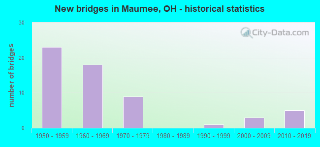
- New bridges - historical statistics
- 231950-1959
- 181960-1969
- 91970-1979
- 11990-1999
- 32000-2009
- 52010-2019

- Reconstructed bridges - Historical Statistics
- 11970-1979
- 81980-1989
- 51990-1999
- 32000-2009
- 32010-2019


- Bridge Condition - Deck
- 9.4%Excellent
- 18.8%Very good
- 65.6%Good
- 6.3%Satisfactory

- Bridge Condition - Superstructure
- 6.3%Excellent
- 43.8%Very good
- 37.5%Good
- 12.5%Satisfactory

- Bridge Condition - Substructure
- 6.3%Excellent
- 21.9%Very good
- 68.8%Good
- 3.1%Satisfactory

- Bridge Condition - Channel
- 7.7%Excellent
- 30.8%Very good
- 30.8%Good
- 30.8%Satisfactory
Find on map >> Show street view
Structure Number: 4800907, Location: 0.2MI EAST OF EXIT 59 (Lat: 41.589950, Lng: -83.664750), Route carried "on" structure: Ramp US 20, Year Built: 1954, Year Reconstructed: 1991, Status: Open, Structure Length: 4.97m (16.31ft), Average Daily Traffic: 4,639 (year 2019), Truck Traffic: 11%, Average Future Daily Traffic: 35,919 (year 2039), Design Load: HS 20, Features Intersected: US 20, Facility Carried by Structure: OH TPK RAMP
Minimum Vertical Clearance: 6.10m (20.01ft), Kilometerpoint: 27.053, Lanes on structure: 2, Lanes under structure: 4, Owner: State Toll Authority, Approaching Roadway Width: 14.0m (45.9ft), Material/Design: Steel continuous, Design/Construction: Stringer/Multi-beam, Number Of Spans In Main Unit: 4, Length of Maximum Span: 16.5m (54.1ft), Curb-To-Curb Width: 9.4m (30.8ft), Out-to-Out Width: 10.3m (33.8ft)
Condition: Deck: Good, Superstructure: Very good, Substructure: Good, Operating Rating: 68.0 metric tons, Method Used To Determine Operating Rating: Load Factor (LF) rating reported by rating factor (RF) method using MS18 loading, Inventory Rating: 42.1 metric tons, Method Used To Determine Inventory Rating: Load Factor (LF) rating reported by rating factor (RF) method using MS18 loading, Structural Evaluation: Better than present minimum criteria, Deck Geometry: Somewhat better than minimum adequacy, Underclear: High priority of corrective action, Approach Roadway Alignment: Equal to present desirable criteria, Designated Inspection Frequency: Every 24 months, Inspection Date: June 2021, Deck Structure Type: Concrete Cast-file-Place, Wearing Surface/Protective System: Wearing Surface: Monolithic Concrete
Find on map >> Show street view
Structure Number: 4800923, Location: JCT US 20 & MAUMEE RIVER (Lat: 41.558989, Lng: -83.651781), Route carried "on" structure: US 20, Year Built: 2002, Status: Open, Structure Length: 26.97m (88.48ft), Average Daily Traffic: 24,220 (year 2010), Truck Traffic: 6%, Average Future Daily Traffic: 33,617 (year 2030), Design Load: HS 25 or greater, Features Intersected: MAUMEE RIVER
Minimum Vertical Clearance: 30+ m (98+ ft), Kilometerpoint: 30.690, Lanes on structure: 4, Base Highway Network: Yes, Owner: State Highway Agency, Approaching Roadway Width: 15.9m (52.2ft), Skew: 9 degrees, Material/Design: Steel continuous, Design/Construction: Stringer/Multi-beam, Number Of Spans In Main Unit: 7, Length of Maximum Span: 39.6m (129.9ft), Curb or Sidewalk Widths: Left: 1.8m (5.9ft), Right: 4.6m (15.1ft), Curb-To-Curb Width: 15.5m (50.9ft), Out-to-Out Width: 22.7m (74.5ft)
Condition: Deck: Good, Superstructure: Very good, Substructure: Good, Channel: Very good, Operating Rating: 42.1 metric tons, Method Used To Determine Operating Rating: Load Factor (LF) rating reported by rating factor (RF) method using MS18 loading, Inventory Rating: 32.4 metric tons, Method Used To Determine Inventory Rating: Load Factor (LF) rating reported by rating factor (RF) method using MS18 loading, Structural Evaluation: Better than present minimum criteria, Deck Geometry: Meets minimum limits, Waterway Adequacy: Superior to present desirable criteria, Approach Roadway Alignment: Equal to present desirable criteria, Designated Inspection Frequency: Every 24 months, Inspection Date: August 2021, Deck Structure Type: Concrete Cast-file-Place, Wearing Surface/Protective System: Wearing Surface: Monolithic Concrete, Deck Protection: Epoxy Coated Reinforcing
Find on map >> Show street view
Structure Number: 4801008, Location: 200 YDS W OF CODER RD (Lat: 41.573619, Lng: -83.710731), Route carried "on" structure: Alternate US 20A, Year Built: 1993, Status: Open, Structure Length: 4.05m (13.29ft), Average Daily Traffic: 7,327 (year 2019), Truck Traffic: 9%, Average Future Daily Traffic: 13,186 (year 2039), Design Load: HS 20+Mod, Features Intersected: SWAN CREEK
Minimum Vertical Clearance: 30+ m (98+ ft), Kilometerpoint: 15.224, Lanes on structure: 2, Owner: State Highway Agency, Approaching Roadway Width: 10.7m (35.1ft), Skew: 1 degrees, Material/Design: Prestressed concrete, Design/Construction: Box Beam or Girders - Multiple, Number Of Spans In Main Unit: 3, Length of Maximum Span: 15.2m (49.9ft), Curb-To-Curb Width: 12.2m (40.0ft), Out-to-Out Width: 12.2m (40.0ft)
Condition: Deck: Good, Superstructure: Good, Substructure: Good, Channel: Satisfactory, Operating Rating: 42.1 metric tons, Method Used To Determine Operating Rating: Load Factor (LF) rating reported by rating factor (RF) method using MS18 loading, Inventory Rating: 32.4 metric tons, Method Used To Determine Inventory Rating: Load Factor (LF) rating reported by rating factor (RF) method using MS18 loading, Structural Evaluation: Better than present minimum criteria, Deck Geometry: Somewhat better than minimum adequacy, Waterway Adequacy: Superior to present desirable criteria, Approach Roadway Alignment: Better than present minimum criteria, Designated Inspection Frequency: Every 24 months, Inspection Date: April 2021, Wearing Surface/Protective System: Wearing Surface: Bituminous, Membrane: Built-up, Deck Protection: Cathodic Protection
Find on map >> Show street view
Structure Number: 4801024, Location: Int. of USR 20A and I 475 (Lat: 41.571681, Lng: -83.691400), Route carried "on" structure: US 20A, Year Built: 1968, Year Reconstructed: 2012, Status: Open, Structure Length: 8.75m (28.71ft), Average Daily Traffic: 7,327 (year 2019), Truck Traffic: 8%, Average Future Daily Traffic: 14,616 (year 2039), Design Load: H 20, Features Intersected: IR 475
Minimum Vertical Clearance: 30+ m (98+ ft), Kilometerpoint: 16.866, Lanes on structure: 2, Lanes under structure: 4, Owner: State Highway Agency, Approaching Roadway Width: 9.8m (32.2ft), Skew: 1 degrees, Material/Design: Steel continuous, Design/Construction: Stringer/Multi-beam, Number Of Spans In Main Unit: 4, Length of Maximum Span: 25.6m (84.0ft), Curb-To-Curb Width: 9.5m (31.2ft), Out-to-Out Width: 11.2m (36.7ft)
Condition: Deck: Good, Superstructure: Good, Substructure: Good, Operating Rating: 42.1 metric tons, Method Used To Determine Operating Rating: Allowable Stress (AS) rating reported by rating factor (RF) method using MS18 loading, Inventory Rating: 32.4 metric tons, Method Used To Determine Inventory Rating: Allowable Stress (AS) rating reported by rating factor (RF) method using MS18 loading, Structural Evaluation: Better than present minimum criteria, Deck Geometry: Meets minimum limits, Underclear: Somewhat better than minimum adequacy, Approach Roadway Alignment: Equal to present desirable criteria, Designated Inspection Frequency: Every 24 months, Inspection Date: April 2021, Deck Structure Type: Concrete Cast-file-Place, Wearing Surface/Protective System: Wearing Surface: Integral Concrete
Find on map >> Show street view
Structure Number: 4801369, Location: JCT. USR 24 & STITT RD. (Lat: 41.535739, Lng: -83.710511), Route carried "on" structure: US 24, Year Built: 1978, Year Reconstructed: 2011, Status: Open, Structure Length: 5.15m (16.90ft), Average Daily Traffic: 17,440 (year 2019), Truck Traffic: 21%, Average Future Daily Traffic: 22,617 (year 2039), Design Load: HS 20+Mod, Features Intersected: STITT RD & N.S.SPUR RR
Minimum Vertical Clearance: 30+ m (98+ ft), Kilometerpoint: 20.326, Lanes on structure: 3, Lanes under structure: 2, Base Highway Network: Yes, Owner: State Highway Agency, Approaching Roadway Width: 15.2m (49.9ft), Material/Design: Steel continuous, Design/Construction: Stringer/Multi-beam, Number Of Spans In Main Unit: 4, Length of Maximum Span: 14.6m (47.9ft), Curb-To-Curb Width: 15.9m (52.2ft), Out-to-Out Width: 16.8m (55.1ft)
Condition: Deck: Very good, Superstructure: Very good, Substructure: Very good, Operating Rating: 68.0 metric tons, Method Used To Determine Operating Rating: Load and Resistance Factor Rating (LRFR) rating reported by rating factor(RF) method using HL-93 loadings, Inventory Rating: 51.8 metric tons, Method Used To Determine Inventory Rating: Load and Resistance Factor Rating (LRFR) rating reported by rating factor(RF) method using HL-93 loadings, Structural Evaluation: Equal to present desirable criteria, Deck Geometry: Somewhat better than minimum adequacy, Underclear: Meets minimum limits, Approach Roadway Alignment: Equal to present desirable criteria, Designated Inspection Frequency: Every 24 months, Inspection Date: March 2021, Deck Structure Type: Concrete Cast-file-Place, Wearing Surface/Protective System: Wearing Surface: Monolithic Concrete, Deck Protection: Epoxy Coated Reinforcing
Find on map >> Show street view
Structure Number: 4801377, Location: JCT USR 24 & STITT RD. (Lat: 41.535550, Lng: -83.710269), Route carried "on" structure: US 24, Year Built: 1978, Year Reconstructed: 2011, Status: Open, Structure Length: 5.24m (17.19ft), Average Daily Traffic: 17,440 (year 2019), Truck Traffic: 21%, Average Future Daily Traffic: 22,617 (year 2039), Design Load: HS 20+Mod, Features Intersected: STITT RD & N.S.SPUR RR
Minimum Vertical Clearance: 30+ m (98+ ft), Kilometerpoint: 20.326, Lanes on structure: 3, Lanes under structure: 2, Base Highway Network: Yes, Owner: State Highway Agency, Approaching Roadway Width: 15.2m (49.9ft), Material/Design: Steel continuous, Design/Construction: Stringer/Multi-beam, Number Of Spans In Main Unit: 4, Length of Maximum Span: 15.2m (49.9ft), Curb-To-Curb Width: 15.9m (52.2ft), Out-to-Out Width: 16.8m (55.1ft)
Condition: Deck: Good, Superstructure: Very good, Substructure: Very good, Operating Rating: 42.1 metric tons, Method Used To Determine Operating Rating: Allowable Stress (AS) rating reported by rating factor (RF) method using MS18 loading, Inventory Rating: 32.4 metric tons, Method Used To Determine Inventory Rating: Allowable Stress (AS) rating reported by rating factor (RF) method using MS18 loading, Structural Evaluation: Equal to present desirable criteria, Deck Geometry: Somewhat better than minimum adequacy, Underclear: Meets minimum limits, Approach Roadway Alignment: Equal to present desirable criteria, Designated Inspection Frequency: Every 24 months, Inspection Date: March 2021, Deck Structure Type: Concrete Cast-file-Place, Wearing Surface/Protective System: Wearing Surface: Monolithic Concrete, Deck Protection: Epoxy Coated Reinforcing
Find on map >> Show street view
Structure Number: 4801385, Location: Jct. US 24 & I-475 (Lat: 41.553169, Lng: -83.686519), Route carried "on" structure: US 24, Year Built: 1966, Year Reconstructed: 2010, Status: Open, Structure Length: 8.99m (29.49ft), Average Daily Traffic: 43,431 (year 2019), Truck Traffic: 21%, Average Future Daily Traffic: 50,000 (year 2039), Design Load: HS 20, Features Intersected: IR 475 & USR 23
Minimum Vertical Clearance: 30+ m (98+ ft), Kilometerpoint: 23.126, Lanes on structure: 6, Lanes under structure: 8, Base Highway Network: Yes, Owner: State Highway Agency, Approaching Roadway Width: 11.6m (38.1ft), Skew: 31 degrees, Material/Design: Steel continuous, Design/Construction: Stringer/Multi-beam, Number Of Spans In Main Unit: 4, Length of Maximum Span: 26.2m (86.0ft), Curb-To-Curb Width: 28.7m (94.2ft), Out-to-Out Width: 30.7m (100.7ft)
Condition: Deck: Good, Superstructure: Good, Substructure: Good, Operating Rating: 38.9 metric tons, Method Used To Determine Operating Rating: Load and Resistance Factor Rating (LRFR) rating reported by rating factor(RF) method using HL-93 loadings, Inventory Rating: 29.2 metric tons, Method Used To Determine Inventory Rating: Load and Resistance Factor Rating (LRFR) rating reported by rating factor(RF) method using HL-93 loadings, Structural Evaluation: Better than present minimum criteria, Deck Geometry: Better than present minimum criteria, Underclear: Somewhat better than minimum adequacy, Approach Roadway Alignment: Equal to present desirable criteria, Designated Inspection Frequency: Every 24 months, Inspection Date: March 2021, Deck Structure Type: Concrete Cast-file-Place, Wearing Surface/Protective System: Wearing Surface: Monolithic Concrete, Deck Protection: Epoxy Coated Reinforcing
Find on map >> Show street view
Structure Number: 4801393, Location: US 24 & Fallen Timbers Ln (Lat: 41.540969, Lng: -83.703800), Route carried "on" structure: County highway C2089, Year Built: 1978, Year Reconstructed: 2021, Status: Open, Structure Length: 6.31m (20.70ft), Average Daily Traffic: 3,041 (year 2019), Truck Traffic: 2%, Average Future Daily Traffic: 4,500 (year 2039), Design Load: HS 20+Mod, Features Intersected: US 24, Facility Carried by Structure: CR 2089
Minimum Vertical Clearance: 30+ m (98+ ft), Kilometerpoint: 0.462, Lanes on structure: 3, Lanes under structure: 4, Owner: State Highway Agency, Approaching Roadway Width: 17.1m (56.1ft), Material/Design: Steel continuous, Design/Construction: Stringer/Multi-beam, Number Of Spans In Main Unit: 2, Length of Maximum Span: 34.1m (111.9ft), Curb-To-Curb Width: 16.6m (54.5ft), Out-to-Out Width: 17.6m (57.7ft)
Condition: Deck: Excellent, Superstructure: Satisfactory, Substructure: Good, Operating Rating: 45.4 metric tons, Method Used To Determine Operating Rating: Load and Resistance Factor Rating (LRFR) rating reported by rating factor(RF) method using HL-93 loadings, Inventory Rating: 35.6 metric tons, Method Used To Determine Inventory Rating: Load and Resistance Factor Rating (LRFR) rating reported by rating factor(RF) method using HL-93 loadings, Structural Evaluation: Equal to present minimum criteria, Deck Geometry: Equal to present desirable criteria, Underclear: Better than present minimum criteria, Approach Roadway Alignment: Equal to present desirable criteria, Designated Inspection Frequency: Every 12 months, Inspection Date: January 2022, Deck Structure Type: Concrete Cast-file-Place, Wearing Surface/Protective System: Wearing Surface: Monolithic Concrete
Find on map >> Show street view
Structure Number: 4807081, Location: JCT. IR 475 & MONCLOVA (Lat: 41.558481, Lng: -83.688019), Route carried "on" structure: Interstate 475, Year Built: 1968, Status: Open, Structure Length: 6.13m (20.11ft), Average Daily Traffic: 30,485 (year 2010), Truck Traffic: 14%, Average Future Daily Traffic: 42,313 (year 2030), Design Load: HS 20, Features Intersected: CR 95-MONCLOVA RD&NS RR
Minimum Vertical Clearance: 30+ m (98+ ft), Kilometerpoint: 1.497, Lanes on structure: 2, Lanes under structure: 2, Base Highway Network: Yes, Owner: State Highway Agency, Approaching Roadway Width: 12.2m (40.0ft), Material/Design: Steel continuous, Design/Construction: Stringer/Multi-beam, Number Of Spans In Main Unit: 3, Length of Maximum Span: 25.3m (83.0ft), Curb or Sidewalk Widths: Left: 0.3m (1.0ft), Right: 0.3m (1.0ft), Curb-To-Curb Width: 16.9m (55.4ft), Out-to-Out Width: 20.7m (67.9ft)
Condition: Deck: Good, Superstructure: Good, Substructure: Good, Operating Rating: 42.1 metric tons, Method Used To Determine Operating Rating: Allowable Stress (AS) rating reported by rating factor (RF) method using MS18 loading, Inventory Rating: 32.4 metric tons, Method Used To Determine Inventory Rating: Allowable Stress (AS) rating reported by rating factor (RF) method using MS18 loading, Structural Evaluation: Better than present minimum criteria, Deck Geometry: Superior to present desirable criteria, Underclear: Meets minimum limits, Approach Roadway Alignment: Equal to present desirable criteria, Designated Inspection Frequency: Every 24 months, Inspection Date: January 2021, Deck Structure Type: Concrete Cast-file-Place, Wearing Surface/Protective System: Wearing Surface: Latex Concrete
Find on map >> Show street view
Structure Number: 4807111, Location: JCT IR 475 & MONCLOVA RD. (Lat: 41.558550, Lng: -83.687519), Route carried "on" structure: Interstate 475, Year Built: 1968, Status: Open, Structure Length: 6.13m (20.11ft), Average Daily Traffic: 30,485 (year 2010), Truck Traffic: 14%, Average Future Daily Traffic: 42,313 (year 2030), Design Load: HS 20, Features Intersected: CR 95-MONCLOVA RD&N.S.RR
Minimum Vertical Clearance: 30+ m (98+ ft), Kilometerpoint: 1.497, Lanes on structure: 2, Lanes under structure: 2, Base Highway Network: Yes, Owner: State Highway Agency, Approaching Roadway Width: 17.1m (56.1ft), Material/Design: Steel continuous, Design/Construction: Stringer/Multi-beam, Number Of Spans In Main Unit: 3, Length of Maximum Span: 25.3m (83.0ft), Curb or Sidewalk Widths: Left: 0.3m (1.0ft), Right: 0.3m (1.0ft), Curb-To-Curb Width: 16.2m (53.1ft), Out-to-Out Width: 18.8m (61.7ft)
Condition: Deck: Good, Superstructure: Good, Substructure: Good, Operating Rating: 42.1 metric tons, Method Used To Determine Operating Rating: Allowable Stress (AS) rating reported by rating factor (RF) method using MS18 loading, Inventory Rating: 32.4 metric tons, Method Used To Determine Inventory Rating: Allowable Stress (AS) rating reported by rating factor (RF) method using MS18 loading, Structural Evaluation: Better than present minimum criteria, Deck Geometry: Superior to present desirable criteria, Underclear: Meets minimum limits, Approach Roadway Alignment: Equal to present desirable criteria, Designated Inspection Frequency: Every 24 months, Inspection Date: January 2021, Deck Structure Type: Concrete Cast-file-Place, Wearing Surface/Protective System: Wearing Surface: Latex Concrete
Find on map >> Show street view
Structure Number: 4807219, Location: JCT SALISBURY RD & I 475 (Lat: 41.581669, Lng: -83.691389), Route carried "on" structure: County highway C0091, Year Built: 2011, Status: Open, Structure Length: 10.67m (35.01ft), Average Daily Traffic: 21,992 (year 2019), Truck Traffic: 6%, Average Future Daily Traffic: 27,000 (year 2039), Design Load: HS 25 or greater, Features Intersected: IR 475, Facility Carried by Structure: SALISBURY RD
Minimum Vertical Clearance: 30+ m (98+ ft), Kilometerpoint: 7.274, Lanes on structure: 7, Lanes under structure: 6, Owner: State Highway Agency, Approaching Roadway Width: 27.4m (89.9ft), Skew: 1 degrees, Material/Design: Prestressed concrete continuous, Design/Construction: Stringer/Multi-beam, Number Of Spans In Main Unit: 4, Length of Maximum Span: 28.0m (91.9ft), Curb-To-Curb Width: 36.9m (121.1ft), Out-to-Out Width: 37.8m (124.0ft)
Condition: Deck: Very good, Superstructure: Very good, Substructure: Very good, Operating Rating: 42.1 metric tons, Method Used To Determine Operating Rating: Load Factor (LF) rating reported by rating factor (RF) method using MS18 loading, Inventory Rating: 32.4 metric tons, Method Used To Determine Inventory Rating: Load Factor (LF) rating reported by rating factor (RF) method using MS18 loading, Structural Evaluation: Equal to present desirable criteria, Deck Geometry: Superior to present desirable criteria, Underclear: Meets minimum limits, Approach Roadway Alignment: Equal to present desirable criteria, Designated Inspection Frequency: Every 24 months, Inspection Date: January 2021, Deck Structure Type: Concrete Cast-file-Place, Wearing Surface/Protective System: Wearing Surface: Monolithic Concrete, Deck Protection: Epoxy Coated Reinforcing
Find on map >> Show street view
Structure Number: 4807286, Location: 1.2 MI WEST OF EXIT 59 (Lat: 41.590400, Lng: -83.691069), Route carried "on" structure: Interstate 475, Year Built: 1968, Year Reconstructed: 2015, Status: Open, Structure Length: 21.28m (69.82ft), Average Daily Traffic: 71,140 (year 2016), Truck Traffic: 13%, Average Future Daily Traffic: 83,810 (year 2036), Design Load: HS 20, Features Intersected: I80,SWN CR, MANLEY RD
Minimum Vertical Clearance: 30+ m (98+ ft), Kilometerpoint: 5.057, Lanes on structure: 2, Lanes under structure: 4, Base Highway Network: Yes, Owner: State Highway Agency, Approaching Roadway Width: 19.5m (64.0ft), Material/Design: Steel continuous, Design/Construction: Stringer/Multi-beam, Number Of Spans In Main Unit: 11, Length of Maximum Span: 21.3m (69.9ft), Curb-To-Curb Width: 19.5m (64.0ft), Out-to-Out Width: 20.4m (66.9ft)
Condition: Deck: Very good, Superstructure: Very good, Substructure: Very good, Channel: Satisfactory, Operating Rating: 68.0 metric tons, Method Used To Determine Operating Rating: Load and Resistance Factor Rating (LRFR) rating reported by rating factor(RF) method using HL-93 loadings, Inventory Rating: 51.8 metric tons, Method Used To Determine Inventory Rating: Load and Resistance Factor Rating (LRFR) rating reported by rating factor(RF) method using HL-93 loadings, Structural Evaluation: Equal to present desirable criteria, Deck Geometry: Superior to present desirable criteria, Underclear: Equal to present minimum criteria, Waterway Adequacy: Superior to present desirable criteria, Approach Roadway Alignment: Equal to present desirable criteria, Designated Inspection Frequency: Every 24 months, Inspection Date: May 2021, Deck Structure Type: Concrete Cast-file-Place, Wearing Surface/Protective System: Wearing Surface: Monolithic Concrete, Deck Protection: Epoxy Coated Reinforcing
Find on map >> Show street view
Structure Number: 4807294, Location: 1.2 MI WEST OF EXIT 59 (Lat: 41.590331, Lng: -83.691439), Route carried "on" structure: Interstate 475, Year Built: 1968, Year Reconstructed: 2015, Status: Open, Structure Length: 21.28m (69.82ft), Average Daily Traffic: 71,140 (year 2016), Truck Traffic: 13%, Average Future Daily Traffic: 83,810 (year 2036), Design Load: HS 20, Features Intersected: I80,SWN CR,MANLEY RD
Minimum Vertical Clearance: 30+ m (98+ ft), Kilometerpoint: 5.057, Lanes on structure: 2, Lanes under structure: 4, Base Highway Network: Yes, Owner: State Highway Agency, Approaching Roadway Width: 19.5m (64.0ft), Material/Design: Steel continuous, Design/Construction: Stringer/Multi-beam, Number Of Spans In Main Unit: 11, Length of Maximum Span: 21.3m (69.9ft), Curb-To-Curb Width: 19.5m (64.0ft), Out-to-Out Width: 20.4m (66.9ft)
Condition: Deck: Very good, Superstructure: Very good, Substructure: Very good, Channel: Good, Operating Rating: 68.0 metric tons, Method Used To Determine Operating Rating: Load and Resistance Factor Rating (LRFR) rating reported by rating factor(RF) method using HL-93 loadings, Inventory Rating: 51.8 metric tons, Method Used To Determine Inventory Rating: Load and Resistance Factor Rating (LRFR) rating reported by rating factor(RF) method using HL-93 loadings, Structural Evaluation: Equal to present desirable criteria, Deck Geometry: Superior to present desirable criteria, Underclear: Somewhat better than minimum adequacy, Waterway Adequacy: Superior to present desirable criteria, Approach Roadway Alignment: Equal to present desirable criteria, Designated Inspection Frequency: Every 24 months, Inspection Date: May 2021, Deck Structure Type: Concrete Cast-file-Place, Wearing Surface/Protective System: Wearing Surface: Monolithic Concrete, Deck Protection: Epoxy Coated Reinforcing
Find on map >> Show street view
Structure Number: 4829603, Location: 1.1MI WEST OF EXIT 59 (Lat: 41.591869, Lng: -83.690239), Route carried "on" structure: Interstate 80K, Year Built: 1954, Year Reconstructed: 1987, Status: Open, Structure Length: 4.51m (14.80ft), Average Daily Traffic: 12,212 (year 2015), Truck Traffic: 43%, Average Future Daily Traffic: 16,950 (year 2035), Design Load: HS 20, Features Intersected: SWAN CREEK, Facility Carried by Structure: I80 OH TPK EB
Minimum Vertical Clearance: 30+ m (98+ ft), Kilometerpoint: 16.254, Lanes on structure: 2, Base Highway Network: Yes, Toll: On toll road, Owner: State Toll Authority, Approaching Roadway Width: 13.4m (44.0ft), Skew: 3 degrees, Material/Design: Steel continuous, Design/Construction: Stringer/Multi-beam, Number Of Spans In Main Unit: 3, Length of Maximum Span: 16.8m (55.1ft), Curb-To-Curb Width: 11.4m (37.4ft), Out-to-Out Width: 12.3m (40.4ft)
Condition: Deck: Good, Superstructure: Good, Substructure: Good, Channel: Good, Operating Rating: 68.0 metric tons, Method Used To Determine Operating Rating: Load Factor (LF) rating reported by rating factor (RF) method using MS18 loading, Inventory Rating: 42.1 metric tons, Method Used To Determine Inventory Rating: Load Factor (LF) rating reported by rating factor (RF) method using MS18 loading, Structural Evaluation: Better than present minimum criteria, Deck Geometry: Somewhat better than minimum adequacy, Waterway Adequacy: Equal to present desirable criteria, Approach Roadway Alignment: Equal to present desirable criteria, Designated Inspection Frequency: Every 24 months, Inspection Date: June 2021, Deck Structure Type: Concrete Cast-file-Place, Wearing Surface/Protective System: Wearing Surface: Monolithic Concrete, Deck Protection: Epoxy Coated Reinforcing
Find on map >> Show street view
Structure Number: 4829611, Location: 1.1MI WEST OF EXIT 59 (Lat: 41.592089, Lng: -83.690039), Route carried "on" structure: Interstate 80K, Year Built: 1954, Year Reconstructed: 1987, Status: Open, Structure Length: 4.51m (14.80ft), Average Daily Traffic: 12,212 (year 2015), Truck Traffic: 43%, Average Future Daily Traffic: 16,950 (year 2035), Design Load: HS 20, Features Intersected: SWAN CREEK, Facility Carried by Structure: I80 OH TPK WB
Minimum Vertical Clearance: 30+ m (98+ ft), Kilometerpoint: 16.254, Lanes on structure: 2, Base Highway Network: Yes, Toll: On toll road, Owner: State Toll Authority, Approaching Roadway Width: 13.4m (44.0ft), Skew: 3 degrees, Material/Design: Steel continuous, Design/Construction: Stringer/Multi-beam, Number Of Spans In Main Unit: 3, Length of Maximum Span: 16.8m (55.1ft), Curb-To-Curb Width: 11.4m (37.4ft), Out-to-Out Width: 12.3m (40.4ft)
Condition: Deck: Good, Superstructure: Very good, Substructure: Good, Channel: Good, Operating Rating: 68.0 metric tons, Method Used To Determine Operating Rating: Load Factor (LF) rating reported by rating factor (RF) method using MS18 loading, Inventory Rating: 42.1 metric tons, Method Used To Determine Inventory Rating: Load Factor (LF) rating reported by rating factor (RF) method using MS18 loading, Structural Evaluation: Better than present minimum criteria, Deck Geometry: Somewhat better than minimum adequacy, Waterway Adequacy: Equal to present desirable criteria, Approach Roadway Alignment: Equal to present desirable criteria, Designated Inspection Frequency: Every 24 months, Inspection Date: June 2021, Deck Structure Type: Concrete Cast-file-Place, Wearing Surface/Protective System: Wearing Surface: Monolithic Concrete, Deck Protection: Epoxy Coated Reinforcing
Find on map >> Show street view
Structure Number: 4829646, Location: 1MI WEST OF EXIT 59 (Lat: 41.591869, Lng: -83.687711), Route carried "on" structure: City street MANLY, Year Built: 1954, Year Reconstructed: 1989, Status: Open, Structure Length: 8.05m (26.41ft), Average Daily Traffic: 6,394 (year 2015), Truck Traffic: 5%, Average Future Daily Traffic: 33,899 (year 2035), Design Load: HS 20+Mod, Features Intersected: I80 OHIO TPK, Facility Carried by Structure: MANLEY RD
Minimum Vertical Clearance: 30+ m (98+ ft), Kilometerpoint: 0.402, Lanes on structure: 2, Lanes under structure: 4, Owner: State Toll Authority, Approaching Roadway Width: 9.8m (32.2ft), Skew: 4 degrees, Material/Design: Steel continuous, Design/Construction: Stringer/Multi-beam, Number Of Spans In Main Unit: 5, Length of Maximum Span: 21.0m (68.9ft), Curb-To-Curb Width: 8.1m (26.6ft), Out-to-Out Width: 9.1m (29.9ft)
Condition: Deck: Good, Superstructure: Very good, Substructure: Good, Operating Rating: 64.8 metric tons, Method Used To Determine Operating Rating: Load Factor (LF) rating reported by rating factor (RF) method using MS18 loading, Inventory Rating: 38.9 metric tons, Method Used To Determine Inventory Rating: Load Factor (LF) rating reported by rating factor (RF) method using MS18 loading, Structural Evaluation: Better than present minimum criteria, Deck Geometry: High priority of corrective action, Underclear: High priority of corrective action, Approach Roadway Alignment: Equal to present desirable criteria, Designated Inspection Frequency: Every 24 months, Inspection Date: June 2021, Deck Structure Type: Concrete Cast-file-Place, Wearing Surface/Protective System: Wearing Surface: Monolithic Concrete, Deck Protection: Epoxy Coated Reinforcing
Find on map >> Show street view
Structure Number: 4829663, Location: 1MI WEST OF EXIT 59 (Lat: 41.591750, Lng: -83.680319), Route carried "on" structure: County highway C1571, Year Built: 2019, Status: Open, Structure Length: 8.45m (27.72ft), Average Daily Traffic: 11,891 (year 2018), Truck Traffic: 5%, Average Future Daily Traffic: 34,819 (year 2038), Design Load: HS 20+Mod, Features Intersected: I80 Ohio Turnpike, Facility Carried by Structure: PERRYSBURG-HOLLAND
Minimum Vertical Clearance: 30+ m (98+ ft), Kilometerpoint: 1.782, Lanes on structure: 4, Lanes under structure: 4, Owner: State Toll Authority, Approaching Roadway Width: 16.5m (54.1ft), Skew: 4 degrees, Material/Design: Steel continuous, Design/Construction: Stringer/Multi-beam, Number Of Spans In Main Unit: 2, Length of Maximum Span: 41.8m (137.1ft), Curb or Sidewalk Widths: Left: 0.0m, Right: 2.1m (6.9ft), Curb-To-Curb Width: 16.5m (54.1ft), Out-to-Out Width: 19.4m (63.6ft)
Condition: Deck: Excellent, Superstructure: Excellent, Substructure: Excellent, Operating Rating: 55.1 metric tons, Method Used To Determine Operating Rating: Load Factor (LF) rating reported by rating factor (RF) method using MS18 loading, Inventory Rating: 33.0 metric tons, Method Used To Determine Inventory Rating: Load Factor (LF) rating reported by rating factor (RF) method using MS18 loading, Structural Evaluation: Superior to present desirable criteria, Deck Geometry: Meets minimum limits, Underclear: Meets minimum limits, Approach Roadway Alignment: Equal to present desirable criteria, Designated Inspection Frequency: Every 12 months, Inspection Date: June 2021, Deck Structure Type: Concrete Cast-file-Place, Wearing Surface/Protective System: Wearing Surface: Monolithic Concrete, Deck Protection: Epoxy Coated Reinforcing
Find on map >> Show street view
Structure Number: 4829689, Location: 0.1MI WEST OF EXIT 59 (Lat: 41.591969, Lng: -83.670839), Route carried "on" structure: Ramp Interstate 80K, Year Built: 2003, Status: Open, Structure Length: 7.83m (25.69ft), Average Daily Traffic: 2,215 (year 2019), Truck Traffic: 20%, Average Future Daily Traffic: 33,899 (year 2039), Design Load: HS 20, Features Intersected: I80 OHIO TPK, Facility Carried by Structure: RAMP EXIT 59
Minimum Vertical Clearance: 30+ m (98+ ft), Kilometerpoint: 17.815, Lanes on structure: 2, Lanes under structure: 4, Toll: On toll road, Owner: State Toll Authority, Approaching Roadway Width: 17.4m (57.1ft), Skew: 20 degrees, Material/Design: Steel continuous, Design/Construction: Stringer/Multi-beam, Number Of Spans In Main Unit: 4, Length of Maximum Span: 26.8m (87.9ft), Curb-To-Curb Width: 17.4m (57.1ft), Out-to-Out Width: 18.3m (60.0ft)
Condition: Deck: Good, Superstructure: Good, Substructure: Good, Operating Rating: 87.5 metric tons, Method Used To Determine Operating Rating: Allowable Stress (AS) rating reported by rating factor (RF) method using MS18 loading, Inventory Rating: 51.8 metric tons, Method Used To Determine Inventory Rating: Allowable Stress (AS) rating reported by rating factor (RF) method using MS18 loading, Structural Evaluation: Better than present minimum criteria, Deck Geometry: Superior to present desirable criteria, Underclear: High priority of corrective action, Approach Roadway Alignment: Equal to present desirable criteria, Designated Inspection Frequency: Every 24 months, Inspection Date: June 2021, Deck Structure Type: Concrete Cast-file-Place, Wearing Surface/Protective System: Wearing Surface: Monolithic Concrete
Find on map >> Show street view
Structure Number: 4829727, Location: 0.2MI EAST OF EXIT 59 (Lat: 41.591881, Lng: -83.664719), Route carried "on" structure: Interstate 80K, Year Built: 1954, Year Reconstructed: 1988, Status: Open, Structure Length: 5.40m (17.72ft), Average Daily Traffic: 14,933 (year 2015), Truck Traffic: 14%, Average Future Daily Traffic: 20,727 (year 2035), Design Load: HS 20, Features Intersected: US 20, Facility Carried by Structure: I80 OH TPK
Minimum Vertical Clearance: 30+ m (98+ ft), Kilometerpoint: 18.330, Lanes on structure: 2, Lanes under structure: 6, Base Highway Network: Yes, Toll: On toll road, Owner: State Toll Authority, Approaching Roadway Width: 13.4m (44.0ft), Material/Design: Steel continuous, Design/Construction: Stringer/Multi-beam, Number Of Spans In Main Unit: 4, Length of Maximum Span: 16.5m (54.1ft), Curb-To-Curb Width: 11.6m (38.1ft), Out-to-Out Width: 12.5m (41.0ft)
Condition: Deck: Good, Superstructure: Good, Substructure: Good, Operating Rating: 61.6 metric tons, Method Used To Determine Operating Rating: Load Factor (LF) rating reported by rating factor (RF) method using MS18 loading, Inventory Rating: 38.9 metric tons, Method Used To Determine Inventory Rating: Load Factor (LF) rating reported by rating factor (RF) method using MS18 loading, Structural Evaluation: Better than present minimum criteria, Deck Geometry: Equal to present minimum criteria, Underclear: Somewhat better than minimum adequacy, Approach Roadway Alignment: Equal to present desirable criteria, Designated Inspection Frequency: Every 24 months, Inspection Date: June 2021, Deck Structure Type: Concrete Cast-file-Place, Wearing Surface/Protective System: Wearing Surface: Monolithic Concrete, Deck Protection: Epoxy Coated Reinforcing
Find on map >> Show street view
Structure Number: 4829751, Location: 0.7MI EAST OF EXIT 59 (Lat: 41.590961, Lng: -83.655089), Route carried "on" structure: City street M2132, Year Built: 1954, Year Reconstructed: 2001, Status: Open, Structure Length: 5.94m (19.49ft), Average Daily Traffic: 5,897 (year 2015), Truck Traffic: 6%, Average Future Daily Traffic: 41,453 (year 2035), Design Load: HS 20+Mod, Features Intersected: I80 OHIO TPK, Facility Carried by Structure: CASS RD
Minimum Vertical Clearance: 30+ m (98+ ft), Kilometerpoint: 3.058, Lanes on structure: 2, Lanes under structure: 4, Owner: State Toll Authority, Approaching Roadway Width: 7.9m (25.9ft), Material/Design: Steel continuous, Design/Construction: Stringer/Multi-beam, Number Of Spans In Main Unit: 2, Number Of Approach Spans: 2, Length of Maximum Span: 20.1m (65.9ft), Curb or Sidewalk Widths: Left: 1.8m (5.9ft), Right: 1.8m (5.9ft), Curb-To-Curb Width: 7.9m (25.9ft), Out-to-Out Width: 12.2m (40.0ft)
Condition: Deck: Good, Superstructure: Good, Substructure: Good, Operating Rating: 64.8 metric tons, Method Used To Determine Operating Rating: Load Factor (LF) rating reported by rating factor (RF) method using MS18 loading, Inventory Rating: 38.9 metric tons, Method Used To Determine Inventory Rating: Load Factor (LF) rating reported by rating factor (RF) method using MS18 loading, Structural Evaluation: Better than present minimum criteria, Deck Geometry: High priority of replacement, Underclear: High priority of corrective action, Approach Roadway Alignment: Equal to present desirable criteria, Designated Inspection Frequency: Every 24 months, Inspection Date: June 2021, Deck Structure Type: Concrete Cast-file-Place, Wearing Surface/Protective System: Wearing Surface: Monolithic Concrete, Deck Protection: Epoxy Coated Reinforcing
Find on map >> Show street view
Structure Number: 4829808, Location: 1.2MI EAST OF EXIT 59 (Lat: 41.590711, Lng: -83.645669), Route carried "on" structure: City street M2133, Year Built: 1954, Year Reconstructed: 1983, Status: Open, Structure Length: 6.19m (20.31ft), Average Daily Traffic: 6,394 (year 2015), Truck Traffic: 5%, Average Future Daily Traffic: 41,453 (year 2035), Design Load: HS 20, Features Intersected: I80 OHIO TPK, Facility Carried by Structure: KEY ST
Minimum Vertical Clearance: 30+ m (98+ ft), Kilometerpoint: 2.639, Lanes on structure: 4, Lanes under structure: 4, Owner: State Toll Authority, Approaching Roadway Width: 14.0m (45.9ft), Material/Design: Steel continuous, Design/Construction: Stringer/Multi-beam, Number Of Spans In Main Unit: 4, Length of Maximum Span: 20.1m (65.9ft), Curb or Sidewalk Widths: Left: 1.1m (3.6ft), Right: 1.1m (3.6ft), Curb-To-Curb Width: 14.0m (45.9ft), Out-to-Out Width: 16.2m (53.1ft)
Condition: Deck: Very good, Superstructure: Very good, Substructure: Good, Operating Rating: 64.8 metric tons, Method Used To Determine Operating Rating: Load Factor (LF) rating reported by rating factor (RF) method using MS18 loading, Inventory Rating: 38.9 metric tons, Method Used To Determine Inventory Rating: Load Factor (LF) rating reported by rating factor (RF) method using MS18 loading, Structural Evaluation: Better than present minimum criteria, Deck Geometry: High priority of replacement, Underclear: High priority of corrective action, Approach Roadway Alignment: Equal to present desirable criteria, Designated Inspection Frequency: Every 24 months, Inspection Date: June 2021, Deck Structure Type: Concrete Cast-file-Place, Wearing Surface/Protective System: Wearing Surface: Latex Concrete, Deck Protection: Epoxy Coated Reinforcing
Find on map >> Show street view
Structure Number: 4829824, Location: 1.5MI EAST OF EXIT 59 (Lat: 41.590389, Lng: -83.640900), Route carried "on" structure: Interstate 80K, Year Built: 1954, Year Reconstructed: 1988, Status: Open, Structure Length: 4.72m (15.49ft), Average Daily Traffic: 14,933 (year 2015), Truck Traffic: 14%, Average Future Daily Traffic: 20,727 (year 2035), Design Load: HS 20, Features Intersected: Michigan Ave, Facility Carried by Structure: I80 OHIO TPK
Minimum Vertical Clearance: 30+ m (98+ ft), Kilometerpoint: 20.358, Lanes on structure: 2, Lanes under structure: 2, Base Highway Network: Yes, Toll: On toll road, Owner: State Toll Authority, Approaching Roadway Width: 19.2m (63.0ft), Skew: 4 degrees, Material/Design: Steel continuous, Design/Construction: Stringer/Multi-beam, Number Of Spans In Main Unit: 3, Length of Maximum Span: 18.0m (59.1ft), Curb-To-Curb Width: 11.4m (37.4ft), Out-to-Out Width: 19.2m (63.0ft)
Condition: Deck: Good, Superstructure: Very good, Substructure: Good, Operating Rating: 61.6 metric tons, Method Used To Determine Operating Rating: Load Factor (LF) rating reported by rating factor (RF) method using MS18 loading, Inventory Rating: 38.9 metric tons, Method Used To Determine Inventory Rating: Load Factor (LF) rating reported by rating factor (RF) method using MS18 loading, Structural Evaluation: Better than present minimum criteria, Deck Geometry: Meets minimum limits, Underclear: High priority of corrective action, Approach Roadway Alignment: Equal to present desirable criteria, Designated Inspection Frequency: Every 24 months, Inspection Date: June 2021, Deck Structure Type: Concrete Cast-file-Place, Wearing Surface/Protective System: Wearing Surface: Monolithic Concrete, Deck Protection: Epoxy Coated Reinforcing
Find on map >> Show street view
Structure Number: 4829859, Location: 1.9MI EAST OF EXIT 59 (Lat: 41.588519, Lng: -83.632281), Route carried "on" structure: Interstate 80K, Year Built: 1954, Year Reconstructed: 1988, Status: Open, Structure Length: 10.64m (34.91ft), Average Daily Traffic: 14,933 (year 2015), Truck Traffic: 14%, Average Future Daily Traffic: 20,727 (year 2035), Design Load: HS 20, Features Intersected: NS RR & STENGEL AVE, Facility Carried by Structure: I80 OH TPK
Minimum Vertical Clearance: 30+ m (98+ ft), Kilometerpoint: 21.098, Lanes on structure: 2, Lanes under structure: 2, Base Highway Network: Yes, Toll: On toll road, Owner: State Toll Authority, Approaching Roadway Width: 19.2m (63.0ft), Skew: 2 degrees, Material/Design: Steel continuous, Design/Construction: Stringer/Multi-beam, Number Of Spans In Main Unit: 5, Length of Maximum Span: 23.8m (78.1ft), Curb-To-Curb Width: 11.4m (37.4ft), Out-to-Out Width: 19.2m (63.0ft)
Condition: Deck: Good, Superstructure: Satisfactory, Substructure: Good, Operating Rating: 61.6 metric tons, Method Used To Determine Operating Rating: Load Factor (LF) rating reported by rating factor (RF) method using MS18 loading, Inventory Rating: 35.6 metric tons, Method Used To Determine Inventory Rating: Load Factor (LF) rating reported by rating factor (RF) method using MS18 loading, Structural Evaluation: Equal to present minimum criteria, Deck Geometry: Meets minimum limits, Underclear: Superior to present desirable criteria, Approach Roadway Alignment: Equal to present desirable criteria, Designated Inspection Frequency: Every 12 months, Inspection Date: June 2021, Deck Structure Type: Concrete Cast-file-Place, Wearing Surface/Protective System: Wearing Surface: Monolithic Concrete, Deck Protection: Epoxy Coated Reinforcing
Find on map >> Show street view
Structure Number: 4829883, Location: 2.4MI EAST OF EXIT 59 (Lat: 41.586100, Lng: -83.624511), Route carried "on" structure: City street CYSTL, Year Built: 1954, Year Reconstructed: 1998, Status: Open, Structure Length: 8.35m (27.40ft), Average Daily Traffic: 22,000 (year 1990), Truck Traffic: 27%, Average Future Daily Traffic: 41,453 (year 2010), Design Load: HS 20+Mod, Features Intersected: I80 OHIO TPK, Facility Carried by Structure: CRYSTAL AVE
Minimum Vertical Clearance: 30+ m (98+ ft), Kilometerpoint: 1.030, Lanes on structure: 2, Lanes under structure: 4, Owner: State Toll Authority, Approaching Roadway Width: 7.3m (24.0ft), Skew: 4 degrees, Material/Design: Steel continuous, Design/Construction: Stringer/Multi-beam, Number Of Spans In Main Unit: 2, Number Of Approach Spans: 2, Length of Maximum Span: 25.9m (85.0ft), Curb or Sidewalk Widths: Left: 1.2m (3.9ft), Right: 1.2m (3.9ft), Curb-To-Curb Width: 7.3m (24.0ft), Out-to-Out Width: 10.4m (34.1ft)
Condition: Deck: Good, Superstructure: Very good, Substructure: Good, Operating Rating: 77.8 metric tons, Method Used To Determine Operating Rating: Load Factor (LF) rating reported by rating factor (RF) method using MS18 loading, Inventory Rating: 45.4 metric tons, Method Used To Determine Inventory Rating: Load Factor (LF) rating reported by rating factor (RF) method using MS18 loading, Structural Evaluation: Better than present minimum criteria, Deck Geometry: High priority of replacement, Underclear: Meets minimum limits, Approach Roadway Alignment: Equal to present desirable criteria, Designated Inspection Frequency: Every 24 months, Inspection Date: June 2021, Deck Structure Type: Concrete Cast-file-Place, Wearing Surface/Protective System: Wearing Surface: Monolithic Concrete, Deck Protection: Epoxy Coated Reinforcing
Find on map >> Show street view
Structure Number: 4829905, Location: 2.7MI EAST OF EXIT 59 (Lat: 41.584661, Lng: -83.618069), Route carried "on" structure: US 24, Year Built: 1954, Year Reconstructed: 1998, Status: Open, Structure Length: 7.28m (23.88ft), Average Daily Traffic: 19,636 (year 2015), Truck Traffic: 5%, Average Future Daily Traffic: 41,453 (year 2035), Design Load: HS 20+Mod, Features Intersected: I80 OHIO TPK, Facility Carried by Structure: DETROIT RD
Minimum Vertical Clearance: 30+ m (98+ ft), Kilometerpoint: 31.286, Lanes on structure: 6, Lanes under structure: 4, Base Highway Network: Yes, Owner: State Toll Authority, Approaching Roadway Width: 18.9m (62.0ft), Skew: 2 degrees, Material/Design: Steel continuous, Design/Construction: Stringer/Multi-beam, Number Of Spans In Main Unit: 4, Length of Maximum Span: 22.9m (75.1ft), Curb or Sidewalk Widths: Left: 1.8m (5.9ft), Right: 1.8m (5.9ft), Curb-To-Curb Width: 41.5m (136.2ft), Out-to-Out Width: 45.7m (149.9ft)
Condition: Deck: Satisfactory, Superstructure: Very good, Substructure: Good, Operating Rating: 64.8 metric tons, Method Used To Determine Operating Rating: Load Factor (LF) rating reported by rating factor (RF) method using MS18 loading, Inventory Rating: 38.9 metric tons, Method Used To Determine Inventory Rating: Load Factor (LF) rating reported by rating factor (RF) method using MS18 loading, Structural Evaluation: Better than present minimum criteria, Deck Geometry: Superior to present desirable criteria, Underclear: Meets minimum limits, Approach Roadway Alignment: Equal to present desirable criteria, Designated Inspection Frequency: Every 12 months, Inspection Date: June 2021, Deck Structure Type: Concrete Cast-file-Place, Wearing Surface/Protective System: Wearing Surface: Monolithic Concrete, Deck Protection: Epoxy Coated Reinforcing
Find on map >> Show street view
Structure Number: 4829921, Location: 3.2MI EAST OF EXIT 59 (Lat: 41.581939, Lng: -83.609381), Route carried "on" structure: City street RIVER, Year Built: 1954, Year Reconstructed: 1995, Status: Open, Structure Length: 6.49m (21.29ft), Average Daily Traffic: 2,034 (year 2015), Truck Traffic: 5%, Average Future Daily Traffic: 41,453 (year 2035), Design Load: HS 20+Mod, Features Intersected: I80 OHIO TPK
Minimum Vertical Clearance: 7.62m (25.00ft), Kilometerpoint: 8.771, Lanes on structure: 2, Lanes under structure: 4, Owner: State Toll Authority, Approaching Roadway Width: 15.2m (49.9ft), Skew: 1 degrees, Material/Design: Steel continuous, Design/Construction: Stringer/Multi-beam, Number Of Spans In Main Unit: 4, Length of Maximum Span: 20.4m (66.9ft), Curb or Sidewalk Widths: Left: 1.5m (4.9ft), Right: 1.5m (4.9ft), Curb-To-Curb Width: 9.8m (32.2ft), Out-to-Out Width: 13.4m (44.0ft)
Condition: Deck: Satisfactory, Superstructure: Good, Substructure: Very good, Operating Rating: 90.7 metric tons, Method Used To Determine Operating Rating: Load Factor (LF) rating reported by rating factor (RF) method using MS18 loading, Inventory Rating: 55.1 metric tons, Method Used To Determine Inventory Rating: Load Factor (LF) rating reported by rating factor (RF) method using MS18 loading, Structural Evaluation: Better than present minimum criteria, Deck Geometry: Meets minimum limits, Underclear: High priority of corrective action, Approach Roadway Alignment: Equal to present desirable criteria, Designated Inspection Frequency: Every 12 months, Inspection Date: June 2021, Deck Structure Type: Concrete Cast-file-Place, Wearing Surface/Protective System: Wearing Surface: Monolithic Concrete, Deck Protection: Epoxy Coated Reinforcing
Find on map >> Show street view
Structure Number: 4829956, Location: 3.4MI EAST OF EXIT 59 (Lat: 41.581611, Lng: -83.608650), Route carried "on" structure: Interstate 80K, Year Built: 1953, Year Reconstructed: 1997, Status: Open, Structure Length: 43.95m (144.19ft), Average Daily Traffic: 14,933 (year 2015), Truck Traffic: 14%, Average Future Daily Traffic: 20,727 (year 2035), Design Load: HS 20+Mod, Features Intersected: MAUMEE RIVER, Facility Carried by Structure: I80 OH TPK
Minimum Vertical Clearance: 30+ m (98+ ft), Kilometerpoint: 23.223, Lanes on structure: 6, Base Highway Network: Yes, Toll: On toll road, Owner: State Toll Authority, Approaching Roadway Width: 12.8m (42.0ft), Navigation Control: Yes ( Vertical Clearance: 12.5m (41.0ft), Horizontal Clearance: 33.5m (109.9ft)), Material/Design: Steel continuous, Design/Construction: Stringer/Multi-beam, Number Of Spans In Main Unit: 11, Length of Maximum Span: 44.2m (145.0ft), Curb-To-Curb Width: 36.8m (120.7ft), Out-to-Out Width: 38.6m (126.6ft)
Condition: Deck: Good, Superstructure: Satisfactory, Substructure: Good, Channel: Good, Operating Rating: 74.5 metric tons, Method Used To Determine Operating Rating: Load Factor (LF) rating reported by rating factor (RF) method using MS18 loading, Inventory Rating: 45.4 metric tons, Method Used To Determine Inventory Rating: Load Factor (LF) rating reported by rating factor (RF) method using MS18 loading, Structural Evaluation: Equal to present minimum criteria, Deck Geometry: Superior to present desirable criteria, Waterway Adequacy: Equal to present desirable criteria, Approach Roadway Alignment: Equal to present desirable criteria, Designated Inspection Frequency: Every 12 months, Underwater Inspection Frequency: Every 60 months, Inspection Date: June 2021, Underwater Inspection Date: July 2019, Deck Structure Type: Concrete Cast-file-Place, Wearing Surface/Protective System: Wearing Surface: Monolithic Concrete, Deck Protection: Epoxy Coated Reinforcing
Find on map >> Show street view
Structure Number: 4830229, Location: 0.05 MILE E. OF ALBON RD. (Lat: 41.558769, Lng: -83.736931), Route carried "on" structure: County highway C0095, Year Built: 2010, Status: Open, Structure Length: 3.02m (9.91ft), Average Daily Traffic: 6,094 (year 2015), Truck Traffic: 5%, Average Future Daily Traffic: 8,458 (year 2035), Design Load: HS 25 or greater, Features Intersected: SWAN CREEK 0727, Facility Carried by Structure: MONCLOVA ROAD
Minimum Vertical Clearance: 30+ m (98+ ft), Kilometerpoint: 12.183, Lanes on structure: 2, Owner: County Highway Agency, Approaching Roadway Width: 12.8m (42.0ft), Material/Design: Prestressed concrete, Design/Construction: Box Beam or Girders - Multiple, Number Of Spans In Main Unit: 1, Length of Maximum Span: 29.9m (98.1ft), Curb or Sidewalk Widths: Left: 3.7m (12.1ft), Right: 0.0m, Curb-To-Curb Width: 12.8m (42.0ft), Out-to-Out Width: 12.8m (42.0ft)
Condition: Deck: Excellent, Superstructure: Excellent, Substructure: Excellent, Channel: Excellent, Operating Rating: 48.6 metric tons, Method Used To Determine Operating Rating: Load Factor (LF) rating reported by rating factor (RF) method using MS18 loading, Inventory Rating: 32.4 metric tons, Method Used To Determine Inventory Rating: Load Factor (LF) rating reported by rating factor (RF) method using MS18 loading, Structural Evaluation: Equal to present desirable criteria, Deck Geometry: Somewhat better than minimum adequacy, Waterway Adequacy: Equal to present desirable criteria, Approach Roadway Alignment: Equal to present desirable criteria, Designated Inspection Frequency: Every 24 months, Inspection Date: October 2021, Deck Structure Type: Concrete Cast-file-Place, Wearing Surface/Protective System: Wearing Surface: Bituminous, Membrane: Preformed Fabric, Deck Protection: Internally Sealed
Find on map >> Show street view
Structure Number: 4831047, Location: 0.7 MI S OF WATRVL-MNCLVA (Lat: 41.548350, Lng: -83.725369), Route carried "on" structure: County highway T0125, Year Built: 1978, Status: Open, Structure Length: 0.70m (2.30ft), Average Daily Traffic: 3,968 (year 2015), Truck Traffic: 5%, Average Future Daily Traffic: 5,508 (year 2035), Design Load: H 20, Features Intersected: BLYSTONE DITCH 0762, Facility Carried by Structure: BLACK RD.
Minimum Vertical Clearance: 30+ m (98+ ft), Kilometerpoint: 1.609, Lanes on structure: 2, Owner: County Highway Agency, Approaching Roadway Width: 11.0m (36.1ft), Material/Design: Steel, Design/Construction: Culvert, Number Of Spans In Main Unit: 1, Length of Maximum Span: 6.7m (22.0ft)
Condition: Channel: Very good, Culverts: Satisfactory, Operating Rating: 42.1 metric tons, Method Used To Determine Operating Rating: Load Factor (LF) rating reported by rating factor (RF) method using MS18 loading, Inventory Rating: 32.4 metric tons, Method Used To Determine Inventory Rating: Load Factor (LF) rating reported by rating factor (RF) method using MS18 loading, Structural Evaluation: Equal to present minimum criteria, Waterway Adequacy: Equal to present desirable criteria, Approach Roadway Alignment: Superior to present desirable criteria, Designated Inspection Frequency: Every 12 months, Inspection Date: October 2021
Find on map >> Show street view
Structure Number: 4831632, Location: 0.02 MI. W. OF STRAYER RD (Lat: 41.583239, Lng: -83.703069), Route carried "on" structure: County highway C0091, Year Built: 1972, Year Reconstructed: 1991, Status: Open, Structure Length: 2.41m (7.91ft), Average Daily Traffic: 8,490 (year 2015), Truck Traffic: 5%, Average Future Daily Traffic: 11,784 (year 2035), Design Load: HS 20+Mod, Features Intersected: SWAN CREEK 0725, Facility Carried by Structure: SALISBURY ROAD
Minimum Vertical Clearance: 30+ m (98+ ft), Kilometerpoint: 11.668, Lanes on structure: 2, Owner: County Highway Agency, Approaching Roadway Width: 14.6m (47.9ft), Skew: 20 degrees, Material/Design: Prestressed concrete, Design/Construction: Stringer/Multi-beam, Number Of Spans In Main Unit: 1, Length of Maximum Span: 22.6m (74.1ft), Curb-To-Curb Width: 14.6m (47.9ft), Out-to-Out Width: 14.6m (47.9ft)
Condition: Deck: Very good, Superstructure: Very good, Substructure: Very good, Channel: Very good, Operating Rating: 42.1 metric tons, Method Used To Determine Operating Rating: Load Factor (LF) rating reported by rating factor (RF) method using MS18 loading, Inventory Rating: 32.4 metric tons, Method Used To Determine Inventory Rating: Load Factor (LF) rating reported by rating factor (RF) method using MS18 loading, Structural Evaluation: Equal to present desirable criteria, Deck Geometry: Superior to present desirable criteria, Waterway Adequacy: Superior to present desirable criteria, Approach Roadway Alignment: Superior to present desirable criteria, Designated Inspection Frequency: Every 24 months, Inspection Date: October 2021, Deck Structure Type: Concrete Cast-file-Place, Wearing Surface/Protective System: Wearing Surface: Latex Concrete, Deck Protection: Epoxy Coated Reinforcing
Find on map >> Show street view
Structure Number: 4831691, Location: 0.01 MI. N. OF MILL RIDGE (Lat: 41.588711, Lng: -83.700411), Route carried "on" structure: County highway T2104, Year Built: 1973, Status: Open, Structure Length: 4.51m (14.80ft), Average Daily Traffic: 1,949 (year 2015), Truck Traffic: 5%, Average Future Daily Traffic: 2,705 (year 2035), Design Load: H 20, Features Intersected: SWAN CREEK 3101, Facility Carried by Structure: BYRNWYK RD. WEST
Minimum Vertical Clearance: 30+ m (98+ ft), Kilometerpoint: 0.451, Lanes on structure: 2, Owner: County Highway Agency, Approaching Roadway Width: 7.3m (24.0ft), Skew: 3 degrees, Material/Design: Prestressed concrete continuous, Design/Construction: Box Beam or Girders - Multiple, Number Of Spans In Main Unit: 3, Length of Maximum Span: 14.9m (48.9ft), Curb or Sidewalk Widths: Left: 1.5m (4.9ft), Right: 0.6m (2.0ft), Curb-To-Curb Width: 7.3m (24.0ft), Out-to-Out Width: 9.3m (30.5ft)
Condition: Deck: Good, Superstructure: Satisfactory, Substructure: Satisfactory, Channel: Very good, Operating Rating: 42.1 metric tons, Method Used To Determine Operating Rating: Load Factor (LF) rating reported by rating factor (RF) method using MS18 loading, Inventory Rating: 32.4 metric tons, Method Used To Determine Inventory Rating: Load Factor (LF) rating reported by rating factor (RF) method using MS18 loading, Structural Evaluation: Equal to present minimum criteria, Deck Geometry: Meets minimum limits, Waterway Adequacy: Equal to present desirable criteria, Approach Roadway Alignment: Equal to present desirable criteria, Designated Inspection Frequency: Every 12 months, Inspection Date: October 2021, Deck Structure Type: Concrete Cast-file-Place, Wearing Surface/Protective System: Wearing Surface: Bituminous
Find on map >> Show street view
Structure Number: 8706751, Location: WOOD LUCAS CO LINE (Lat: 41.544319, Lng: -83.682289), Route carried "on" structure: Interstate 475, Year Built: 1964, Status: Open, Structure Length: 28.47m (93.41ft), Average Daily Traffic: 27,969 (year 2015), Truck Traffic: 26%, Average Future Daily Traffic: 38,821 (year 2035), Design Load: HS 20, Features Intersected: MAUMEE RIV & S RIVER ROA
Minimum Vertical Clearance: 30+ m (98+ ft), Kilometerpoint: 6.212, Lanes on structure: 2, Lanes under structure: 2, Base Highway Network: Yes, Owner: State Highway Agency, Approaching Roadway Width: 9.8m (32.2ft), Skew: 1 degrees, Material/Design: Steel, Design/Construction: Girder and Floorbeam System, Number Of Spans In Main Unit: 7, Length of Maximum Span: 43.0m (141.1ft), Curb-To-Curb Width: 9.1m (29.9ft), Out-to-Out Width: 11.2m (36.7ft)
Condition: Deck: Good, Superstructure: Good, Substructure: Good, Channel: Satisfactory, Operating Rating: 45.4 metric tons, Method Used To Determine Operating Rating: Load and Resistance Factor Rating (LRFR) rating reported by rating factor(RF) method using HL-93 loadings, Inventory Rating: 35.6 metric tons, Method Used To Determine Inventory Rating: Load and Resistance Factor Rating (LRFR) rating reported by rating factor(RF) method using HL-93 loadings, Structural Evaluation: Better than present minimum criteria, Deck Geometry: Meets minimum limits, Underclear: Better than present minimum criteria, Waterway Adequacy: Equal to present desirable criteria, Approach Roadway Alignment: Equal to present desirable criteria, Designated Inspection Frequency: Every 12 months, Critical Feature Inspection Frequency: Every 24 months, Underwater Inspection Frequency: Every 60 months, Inspection Date: August 2021, Critical Feature Inspection Date: August 2021, Underwater Inspection Date: April 2020, Deck Structure Type: Concrete Cast-file-Place, Wearing Surface/Protective System: Wearing Surface: Integral Concrete
Find on map >> Show street view
Structure Number: 8706786, Location: WOOD LUCAS COUNTY LINE (Lat: 41.544511, Lng: -83.681969), Route carried "on" structure: Interstate 475, Year Built: 1964, Status: Open, Structure Length: 28.47m (93.41ft), Average Daily Traffic: 27,969 (year 2015), Truck Traffic: 26%, Average Future Daily Traffic: 38,821 (year 2035), Design Load: HS 20, Features Intersected: MAUMEE RIV & S RIVER ROA
Minimum Vertical Clearance: 30+ m (98+ ft), Kilometerpoint: 6.212, Lanes on structure: 2, Lanes under structure: 2, Base Highway Network: Yes, Owner: State Highway Agency, Approaching Roadway Width: 9.8m (32.2ft), Skew: 1 degrees, Material/Design: Steel, Design/Construction: Girder and Floorbeam System, Number Of Spans In Main Unit: 7, Length of Maximum Span: 43.0m (141.1ft), Curb-To-Curb Width: 9.1m (29.9ft), Out-to-Out Width: 11.2m (36.7ft)
Condition: Deck: Good, Superstructure: Good, Substructure: Good, Channel: Satisfactory, Operating Rating: 45.4 metric tons, Method Used To Determine Operating Rating: Load and Resistance Factor Rating (LRFR) rating reported by rating factor(RF) method using HL-93 loadings, Inventory Rating: 35.6 metric tons, Method Used To Determine Inventory Rating: Load and Resistance Factor Rating (LRFR) rating reported by rating factor(RF) method using HL-93 loadings, Structural Evaluation: Better than present minimum criteria, Deck Geometry: Meets minimum limits, Underclear: Better than present minimum criteria, Waterway Adequacy: Equal to present desirable criteria, Approach Roadway Alignment: Equal to present desirable criteria, Designated Inspection Frequency: Every 12 months, Critical Feature Inspection Frequency: Every 24 months, Underwater Inspection Frequency: Every 60 months, Inspection Date: August 2021, Critical Feature Inspection Date: August 2021, Underwater Inspection Date: April 2020, Deck Structure Type: Concrete Cast-file-Place, Wearing Surface/Protective System: Wearing Surface: Integral Concrete
Find on map >> Show street view
Structure Number: 4800907, Location: 0.2MI EAST OF EXIT 59 (Lat: 41.589950, Lng: -83.664750), Route carried "under" structure: US 20, Year Built: 1954, Structure Length: 0. m, Average Daily Traffic: 25,878 (year 2015), Truck Traffic: 4%, Features Intersected: OH TPK RMP
Minimum Vertical Clearance: 4.52m (14.83ft), Kilometerpoint: 27.005, Lanes on structure: 2, Lanes under structure: 4, Material/Design: Steel continuous, Design/Construction: Stringer/Multi-beam, Length of Maximum Span: 16.5m (54.1ft)
Find on map >> Show street view
Structure Number: 4801024, Location: Int. of USR 20A and I 475 (Lat: 41.571681, Lng: -83.691400), Route carried "under" structure: Interstate 475, Year Built: 1968, Structure Length: 0. m, Average Daily Traffic: 80,199 (year 2019), Truck Traffic: 9%, Features Intersected: USR 20A
Minimum Vertical Clearance: 4.95m (16.24ft), Kilometerpoint: 2.977, Lanes on structure: 2, Lanes under structure: 4, Material/Design: Steel continuous, Design/Construction: Stringer/Multi-beam, Length of Maximum Span: 25.6m (84.0ft)
Find on map >> Show street view
Structure Number: 4801369, Location: JCT. USR 24 & STITT RD. (Lat: 41.535739, Lng: -83.710511), Route carried "under" structure: County highway C0128, Year Built: 1978, Structure Length: 0. m, Average Daily Traffic: 1,161 (year 2019), Truck Traffic: 3%, Features Intersected: USR 24, Facility Carried by Structure: CR 128 Stitt Rd.
Minimum Vertical Clearance: 5.23m (17.16ft), Kilometerpoint: 5.359, Lanes on structure: 3, Lanes under structure: 2, Material/Design: Steel continuous, Design/Construction: Stringer/Multi-beam, Length of Maximum Span: 14.6m (47.9ft)
Find on map >> Show street view
Structure Number: 4801377, Location: JCT USR 24 & STITT RD. (Lat: 41.535550, Lng: -83.710269), Route carried "under" structure: County highway 128, Year Built: 1978, Structure Length: 0. m, Average Daily Traffic: 1,161 (year 2019), Truck Traffic: 3%, Features Intersected: USR 24
Minimum Vertical Clearance: 5.79m (19.00ft), Kilometerpoint: 5.359, Lanes on structure: 3, Lanes under structure: 2, Material/Design: Steel continuous, Design/Construction: Stringer/Multi-beam, Length of Maximum Span: 15.2m (49.9ft)
Find on map >> Show street view
Structure Number: 4801385, Location: Jct. US 24 & I-475 (Lat: 41.553169, Lng: -83.686519), Route carried "under" structure: Interstate 475, Year Built: 1966, Structure Length: 0. m, Average Daily Traffic: 68,969 (year 2019), Truck Traffic: 9%, Features Intersected: USR 24
Minimum Vertical Clearance: 5.18m (16.99ft), Kilometerpoint: 0.901, Lanes on structure: 6, Lanes under structure: 8, Material/Design: Steel continuous, Design/Construction: Stringer/Multi-beam, Length of Maximum Span: 26.2m (86.0ft)
Find on map >> Show street view
Structure Number: 4801393, Location: US 24 & Fallen Timbers Ln (Lat: 41.540969, Lng: -83.703800), Route carried "under" structure: US 24, Year Built: 1978, Structure Length: 0. m, Average Daily Traffic: 43,431 (year 2019), Truck Traffic: 21%, Features Intersected: CR 2089
Minimum Vertical Clearance: 5.11m (16.77ft), Kilometerpoint: 21.115, Lanes on structure: 3, Lanes under structure: 4, Material/Design: Steel continuous, Design/Construction: Stringer/Multi-beam, Length of Maximum Span: 34.1m (111.9ft)
Find on map >> Show street view
Structure Number: 4807081, Location: JCT. IR 475 & MONCLOVA (Lat: 41.558481, Lng: -83.688019), Route carried "under" structure: County highway 95, Year Built: 1968, Structure Length: 0. m, Average Daily Traffic: 11,009 (year 2019), Truck Traffic: 3%, Features Intersected: IR 475
Minimum Vertical Clearance: 7.01m (23.00ft), Kilometerpoint: 14.886, Lanes on structure: 2, Lanes under structure: 2, Material/Design: Steel continuous, Design/Construction: Stringer/Multi-beam, Length of Maximum Span: 25.3m (83.0ft)
Find on map >> Show street view
Structure Number: 4807111, Location: JCT IR 475 & MONCLOVA RD. (Lat: 41.558550, Lng: -83.687519), Route carried "under" structure: County highway 95, Year Built: 1968, Structure Length: 0. m, Average Daily Traffic: 11,009 (year 2019), Truck Traffic: 3%, Features Intersected: IR 475
Minimum Vertical Clearance: 7.01m (23.00ft), Kilometerpoint: 14.903, Lanes on structure: 2, Lanes under structure: 2, Material/Design: Steel continuous, Design/Construction: Stringer/Multi-beam, Length of Maximum Span: 25.3m (83.0ft)
Find on map >> Show street view
Structure Number: 4807219, Location: JCT SALISBURY RD & I 475 (Lat: 41.581669, Lng: -83.691389), Route carried "under" structure: Interstate 475, Year Built: 2011, Structure Length: 0. m, Average Daily Traffic: 86,941 (year 2019), Truck Traffic: 9%, Features Intersected: CR 91 Salisbury Rd.
Minimum Vertical Clearance: 5.18m (16.99ft), Kilometerpoint: 4.088, Lanes on structure: 7, Lanes under structure: 6, Material/Design: Prestressed concrete continuous, Design/Construction: Stringer/Multi-beam, Length of Maximum Span: 28.0m (91.9ft)
Find on map >> Show street view
Structure Number: 4807286, Location: 1.2 MI WEST OF EXIT 59 (Lat: 41.590400, Lng: -83.691069), Route carried "under" structure: Interstate 80K, Year Built: 1968, Structure Length: 0. m, Average Daily Traffic: 25,086 (year 2018), Truck Traffic: 45%, Features Intersected: IR475NB & US23, Facility Carried by Structure: IR80
Minimum Vertical Clearance: 5.26m (17.26ft), Kilometerpoint: 16.142, Lanes on structure: 2, Lanes under structure: 4, Toll: On toll road, Material/Design: Steel continuous, Design/Construction: Stringer/Multi-beam, Length of Maximum Span: 21.3m (69.9ft)
Find on map >> Show street view
Structure Number: 4807286, Location: 1.2 MI WEST OF EXIT 59 (Lat: 41.590400, Lng: -83.691069), Route carried "under" structure: County highway CR103, Year Built: 1968, Structure Length: 0. m, Average Daily Traffic: 6,985 (year 2018), Features Intersected: IR 475NB & US 23, Facility Carried by Structure: Manley Rd.
Minimum Vertical Clearance: 5.26m (17.26ft), Kilometerpoint: 1.183, Lanes on structure: 2, Lanes under structure: 4, Material/Design: Steel continuous, Design/Construction: Stringer/Multi-beam, Length of Maximum Span: 21.3m (69.9ft)