Bridge Statistics for Manchester, Tennessee (TN)
Condition, Traffic, Stress, Structural Evaluation, Project Costs
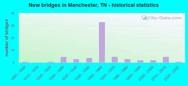
- New bridges - historical statistics
- 11900-1909
- 11920-1929
- 51930-1939
- 31940-1949
- 41950-1959
- 331960-1969
- 51970-1979
- 31980-1989
- 21990-1999
- 22000-2009
- 52010-2019
- 12020-2022

- Reconstructed bridges - Historical Statistics
- 11950-1959
- 31960-1969
- 01970-1979
- 21980-1989
- 11990-1999
- 12000-2009
- 12010-2019


- Bridge Condition - Deck
- 7.9%Very good
- 44.7%Good
- 26.3%Satisfactory
- 18.4%Fair
- 2.6%Poor

- Bridge Condition - Superstructure
- 5.3%Very good
- 39.5%Good
- 31.6%Satisfactory
- 18.4%Fair
- 2.6%Poor
- 2.6%Critical

- Bridge Condition - Substructure
- 5.3%Very good
- 47.4%Good
- 28.9%Satisfactory
- 18.4%Fair

- Bridge Condition - Channel
- 14.6%Very good
- 51.2%Good
- 22.0%Satisfactory
- 12.2%Fair

- Bridge Condition - Culverts
- 5.6%Very good
- 38.9%Good
- 38.9%Satisfactory
- 16.7%Fair
Find on map >> Show street view
Structure Number: 16010960001, Location: .8 MI FROM SHED RD (Lat: 35.496917, Lng: -86.027817), Route carried "on" structure: County highway 1096, Year Built: 1940, Year Reconstructed: 2017, Status: Posted for load, Structure Length: 2.29m (7.51ft), Average Daily Traffic: 977 (year 2020), Truck Traffic: 3%, Average Future Daily Traffic: 1,563 (year 2042), Design Load: HS 15, Features Intersected: TAYLOR BRANCH
Minimum Vertical Clearance: 30+ m (98+ ft), Kilometerpoint: 4.683, Lanes on structure: 2, Owner: County Highway Agency, Approaching Roadway Width: 6.4m (21.0ft), Material/Design: Concrete, Design/Construction: Tee Beam, Number Of Spans In Main Unit: 3, Length of Maximum Span: 7.6m (24.9ft), Curb-To-Curb Width: 6.1m (20.0ft), Out-to-Out Width: 6.4m (21.0ft)
Condition: Deck: Fair, Superstructure: Fair, Substructure: Fair, Channel: Fair, Operating Rating: 36.0 metric tons, Method Used To Determine Operating Rating: Field evaluation and documented engineering judgment, Inventory Rating: 24.3 metric tons, Method Used To Determine Inventory Rating: Field evaluation and documented engineering judgment, Structural Evaluation: Somewhat better than minimum adequacy, Deck Geometry: High priority of corrective action, Waterway Adequacy: Better than present minimum criteria, Approach Roadway Alignment: Equal to present minimum criteria, Length Of Structure Improvement: 2.29m (7.51ft), Designated Inspection Frequency: Every 24 months, Inspection Date: Febuary 2022, Bridge Improvement Cost: $198,000, Roadway Improvement Cost: $20,000, Total Project Cost: $298,000 ( Estimate for 2022), Deck Structure Type: Concrete Cast-file-Place, Wearing Surface/Protective System: Wearing Surface: Bituminous
Find on map >> Show street view
Structure Number: 16034100001, Location: E. JCT. 3410 W / SR 53 (Lat: 35.499217, Lng: -86.081217), Route carried "on" structure: City street 3410, Year Built: 1970, Status: Open, Structure Length: 0.67m (2.20ft), Average Daily Traffic: 5,392 (year 2020), Truck Traffic: 4%, Average Future Daily Traffic: 11,072 (year 2040), Design Load: H 20, Features Intersected: GOODMAN SPRING BRANCH
Minimum Vertical Clearance: 30+ m (98+ ft), Kilometerpoint: 0.563, Lanes on structure: 2, Owner: City or Municipal Highway Agency, Approaching Roadway Width: 10.4m (34.1ft), Material/Design: Concrete continuous, Design/Construction: Culvert, Number Of Spans In Main Unit: 2, Length of Maximum Span: 3.0m (9.8ft)
Condition: Channel: Good, Culverts: Good, Operating Rating: 89.1 metric tons, Method Used To Determine Operating Rating: Load Factor (LF), Inventory Rating: 32.4 metric tons, Method Used To Determine Inventory Rating: Load Factor (LF), Structural Evaluation: Better than present minimum criteria, Waterway Adequacy: Better than present minimum criteria, Approach Roadway Alignment: Equal to present desirable criteria, Designated Inspection Frequency: Every 24 months, Inspection Date: January 2022
Find on map >> Show street view
Structure Number: 16034110001, Location: IN MANCHESTER CITY LIMITS (Lat: 35.485917, Lng: -86.086883), Route carried "on" structure: City street 3411, Year Built: 1930, Status: Open, Structure Length: 7.86m (25.79ft), Average Daily Traffic: 2,958 (year 2020), Truck Traffic: 1%, Average Future Daily Traffic: 5,840 (year 2041), Design Load: H 15, Features Intersected: LITTLE DUCK RIVER
Minimum Vertical Clearance: 30+ m (98+ ft), Kilometerpoint: 0.547, Lanes on structure: 2, Owner: City or Municipal Highway Agency, Approaching Roadway Width: 8.8m (28.9ft), Material/Design: Concrete, Design/Construction: Tee Beam, Number Of Spans In Main Unit: 6, Length of Maximum Span: 13.1m (43.0ft), Curb-To-Curb Width: 7.3m (24.0ft), Out-to-Out Width: 8.3m (27.2ft)
Condition: Deck: Satisfactory, Superstructure: Fair, Substructure: Satisfactory, Channel: Satisfactory, Operating Rating: 31.1 metric tons, Method Used To Determine Operating Rating: Load and Resistance Factor Rating (LRFR) rating reported by rating factor(RF) method using HL-93 loadings, Inventory Rating: 24.9 metric tons, Method Used To Determine Inventory Rating: Load and Resistance Factor Rating (LRFR) rating reported by rating factor(RF) method using HL-93 loadings, Structural Evaluation: Somewhat better than minimum adequacy, Deck Geometry: High priority of replacement, Waterway Adequacy: Better than present minimum criteria, Approach Roadway Alignment: Equal to present minimum criteria, Length Of Structure Improvement: 7.86m (25.79ft), Designated Inspection Frequency: Every 24 months, Inspection Date: January 2022, Bridge Improvement Cost: $781,000, Roadway Improvement Cost: $79,000, Total Project Cost: $1,172,000 ( Estimate for 2021), Deck Structure Type: Concrete Cast-file-Place, Wearing Surface/Protective System: Wearing Surface: Bituminous
Find on map >> Show street view
Structure Number: 16034120001, Location: NEAR MANCHESTER TENN. (Lat: 35.484467, Lng: -86.081150), Route carried "on" structure: City street 3412, Year Built: 1980, Status: Open, Structure Length: 6.07m (19.91ft), Average Daily Traffic: 997 (year 2020), Truck Traffic: 4%, Average Future Daily Traffic: 2,128 (year 2040), Design Load: HS 20+Mod, Features Intersected: LITTLE DUCK RIVER
Minimum Vertical Clearance: 30+ m (98+ ft), Kilometerpoint: 0.885, Lanes on structure: 2, Owner: City or Municipal Highway Agency, Approaching Roadway Width: 11.0m (36.1ft), Skew: 1 degrees, Material/Design: Prestressed concrete continuous, Design/Construction: Box Beam or Girders - Single/Spread, Number Of Spans In Main Unit: 3, Length of Maximum Span: 20.1m (65.9ft), Curb or Sidewalk Widths: Left: 0.0m, Right: 1.5m (4.9ft), Curb-To-Curb Width: 8.8m (28.9ft), Out-to-Out Width: 11.0m (36.1ft)
Condition: Deck: Good, Superstructure: Good, Substructure: Good, Channel: Good, Operating Rating: 58.9 metric tons, Method Used To Determine Operating Rating: Load Factor (LF), Inventory Rating: 32.4 metric tons, Method Used To Determine Inventory Rating: Load Factor (LF), Structural Evaluation: Better than present minimum criteria, Deck Geometry: Somewhat better than minimum adequacy, Waterway Adequacy: Better than present minimum criteria, Approach Roadway Alignment: Equal to present minimum criteria, Designated Inspection Frequency: Every 24 months, Inspection Date: January 2022, Deck Structure Type: Concrete Precast Panels, Wearing Surface/Protective System: Wearing Surface: Bituminous, Membrane: Preformed Fabric
Find on map >> Show street view
Structure Number: 16034150001, Location: 4 MI E OF I24 MCKELLAR DR (Lat: 35.474100, Lng: -86.070450), Route carried "on" structure: City street 152, Year Built: 2010, Status: Open, Structure Length: 1.73m (5.68ft), Average Daily Traffic: 910 (year 2018), Truck Traffic: 1%, Average Future Daily Traffic: 1,456 (year 2040), Design Load: HS 20, Features Intersected: LITTLE DUCK RIVER
Minimum Vertical Clearance: 30+ m (98+ ft), Kilometerpoint: 0.547, Lanes on structure: 2, Owner: City or Municipal Highway Agency, Approaching Roadway Width: 9.8m (32.2ft), Skew: 10 degrees, Material/Design: Concrete continuous, Design/Construction: Culvert, Number Of Spans In Main Unit: 3, Length of Maximum Span: 5.5m (18.0ft), Curb-To-Curb Width: 9.8m (32.2ft), Out-to-Out Width: 10.8m (35.4ft)
Condition: Channel: Good, Culverts: Good, Operating Rating: 54.1 metric tons, Method Used To Determine Operating Rating: Assigned ratings based on Load and Resistance Factor Design (LRFD) reported by rating factor (RF) using HL93 loadings, Inventory Rating: 32.4 metric tons, Method Used To Determine Inventory Rating: Assigned ratings based on Load and Resistance Factor Design (LRFD) reported by rating factor (RF) using HL93 loadings, Structural Evaluation: Better than present minimum criteria, Deck Geometry: Equal to present minimum criteria, Waterway Adequacy: Equal to present desirable criteria, Approach Roadway Alignment: Equal to present minimum criteria, Designated Inspection Frequency: Every 24 months, Inspection Date: January 2022, Deck Structure Type: Concrete Cast-file-Place, Wearing Surface/Protective System: Wearing Surface: Bituminous
Find on map >> Show street view
Structure Number: 160A0300005, Location: .2 MI FROM SR 55 (Lat: 35.410783, Lng: -86.130450), Route carried "on" structure: County highway 30, Year Built: 1934, Status: Open, Structure Length: 1.71m (5.61ft), Average Daily Traffic: 1,460 (year 2022), Truck Traffic: 2%, Average Future Daily Traffic: 2,336 (year 2040), Design Load: H 15, Features Intersected: HICKERSON SPRINGS BRANCH
Minimum Vertical Clearance: 30+ m (98+ ft), Kilometerpoint: 5.121, Lanes on structure: 2, Owner: County Highway Agency, Approaching Roadway Width: 7.0m (23.0ft), Material/Design: Concrete, Design/Construction: Tee Beam, Number Of Spans In Main Unit: 2, Length of Maximum Span: 7.6m (24.9ft), Curb-To-Curb Width: 6.8m (22.3ft), Out-to-Out Width: 7.2m (23.6ft)
Condition: Deck: Fair, Superstructure: Fair, Substructure: Fair, Channel: Satisfactory, Operating Rating: 36.0 metric tons, Method Used To Determine Operating Rating: Field evaluation and documented engineering judgment, Inventory Rating: 24.3 metric tons, Method Used To Determine Inventory Rating: Field evaluation and documented engineering judgment, Structural Evaluation: Somewhat better than minimum adequacy, Deck Geometry: High priority of corrective action, Waterway Adequacy: Equal to present desirable criteria, Approach Roadway Alignment: Equal to present desirable criteria, Length Of Structure Improvement: 1.71m (5.61ft), Designated Inspection Frequency: Every 24 months, Inspection Date: March 2020, Bridge Improvement Cost: $185,000, Roadway Improvement Cost: $19,000, Total Project Cost: $278,000 ( Estimate for 2020), Deck Structure Type: Concrete Cast-file-Place, Wearing Surface/Protective System: Wearing Surface: Bituminous
Find on map >> Show street view
Structure Number: 160A0300009, Location: .2 MI FROM SR 55 (Lat: 35.434717, Lng: -86.105367), Route carried "on" structure: City street 30, Year Built: 1936, Status: Posted for load, Structure Length: 0.98m (3.22ft), Average Daily Traffic: 920 (year 2022), Truck Traffic: 2%, Average Future Daily Traffic: 1,472 (year 2042), Design Load: H 15, Features Intersected: WILEY CREEK
Minimum Vertical Clearance: 30+ m (98+ ft), Kilometerpoint: 8.808, Lanes on structure: 2, Owner: City or Municipal Highway Agency, Approaching Roadway Width: 7.0m (23.0ft), Material/Design: Concrete, Design/Construction: Tee Beam, Number Of Spans In Main Unit: 1, Length of Maximum Span: 7.6m (24.9ft), Curb-To-Curb Width: 6.8m (22.3ft), Out-to-Out Width: 7.2m (23.6ft)
Condition: Deck: Poor, Superstructure: Poor, Substructure: Satisfactory, Channel: Fair, Operating Rating: 36.0 metric tons, Method Used To Determine Operating Rating: Field evaluation and documented engineering judgment, Inventory Rating: 24.3 metric tons, Method Used To Determine Inventory Rating: Field evaluation and documented engineering judgment, Structural Evaluation: Meets minimum limits, Deck Geometry: Meets minimum limits, Waterway Adequacy: Equal to present minimum criteria, Approach Roadway Alignment: Equal to present desirable criteria, Length Of Structure Improvement: 0.98m (3.22ft), Designated Inspection Frequency: Every 24 months, Inspection Date: January 2022, Bridge Improvement Cost: $91,000, Roadway Improvement Cost: $10,000, Total Project Cost: $137,000 ( Estimate for 2022), Deck Structure Type: Concrete Cast-file-Place, Wearing Surface/Protective System: Wearing Surface: Bituminous
Find on map >> Show street view
Structure Number: 160A1350001, Location: 1 MI FROM ASHBURY RD (Lat: 35.460167, Lng: -85.972450), Route carried "on" structure: County highway 135, Year Built: 1960, Status: Open, Structure Length: 0.94m (3.08ft), Average Daily Traffic: 30 (year 2022), Truck Traffic: 2%, Average Future Daily Traffic: 48 (year 2040), Features Intersected: WARREN BRANCH
Minimum Vertical Clearance: 30+ m (98+ ft), Kilometerpoint: 0.512, Lanes on structure: 2, Owner: County Highway Agency, Approaching Roadway Width: 6.7m (22.0ft), Material/Design: Concrete continuous, Design/Construction: Culvert, Number Of Spans In Main Unit: 2, Length of Maximum Span: 4.6m (15.1ft), Curb-To-Curb Width: 6.2m (20.3ft), Out-to-Out Width: 6.6m (21.7ft)
Condition: Channel: Satisfactory, Culverts: Satisfactory, Operating Rating: 42.1 metric tons, Method Used To Determine Operating Rating: Load Factor (LF), Inventory Rating: 24.3 metric tons, Method Used To Determine Inventory Rating: Load Factor (LF), Structural Evaluation: Equal to present minimum criteria, Deck Geometry: Somewhat better than minimum adequacy, Waterway Adequacy: Better than present minimum criteria, Approach Roadway Alignment: Equal to present desirable criteria, Designated Inspection Frequency: Every 24 months, Inspection Date: Febuary 2022, Deck Structure Type: Concrete Cast-file-Place, Wearing Surface/Protective System: Wearing Surface: Bituminous
Find on map >> Show street view
Structure Number: 160A1390001, Location: 5 MI FROM SR 55 (Lat: 35.491150, Lng: -86.032483), Route carried "on" structure: County highway 139, Year Built: 1966, Status: Open, Structure Length: 2.38m (7.81ft), Average Daily Traffic: 70 (year 2022), Truck Traffic: 2%, Average Future Daily Traffic: 112 (year 2040), Features Intersected: WOLF CREEK
Minimum Vertical Clearance: 30+ m (98+ ft), Kilometerpoint: 1.291, Lanes on structure: 2, Owner: County Highway Agency, Approaching Roadway Width: 6.1m (20.0ft), Skew: 1 degrees, Material/Design: Concrete continuous, Design/Construction: Culvert, Number Of Spans In Main Unit: 4, Length of Maximum Span: 5.2m (17.1ft), Curb-To-Curb Width: 6.7m (22.0ft), Out-to-Out Width: 7.3m (24.0ft)
Condition: Channel: Satisfactory, Culverts: Satisfactory, Operating Rating: 39.6 metric tons, Method Used To Determine Operating Rating: Load Factor (LF), Inventory Rating: 18.0 metric tons, Method Used To Determine Inventory Rating: Load Factor (LF), Structural Evaluation: Somewhat better than minimum adequacy, Deck Geometry: Somewhat better than minimum adequacy, Waterway Adequacy: Equal to present minimum criteria, Approach Roadway Alignment: Equal to present minimum criteria, Length Of Structure Improvement: 2.38m (7.81ft), Designated Inspection Frequency: Every 24 months, Inspection Date: March 2020, Bridge Improvement Cost: $302,000, Roadway Improvement Cost: $31,000, Total Project Cost: $454,000 ( Estimate for 2020), Deck Structure Type: Concrete Cast-file-Place, Wearing Surface/Protective System: Wearing Surface: Bituminous
Find on map >> Show street view
Structure Number: 160A1400001, Location: .1 MI FROM I24 (Lat: 35.481233, Lng: -86.064317), Route carried "on" structure: City street 140, Year Built: 1960, Status: Posted for load, Structure Length: 2.13m (6.99ft), Average Daily Traffic: 840 (year 2018), Truck Traffic: 1%, Average Future Daily Traffic: 1,344 (year 2040), Features Intersected: WOLF CREEK
Minimum Vertical Clearance: 30+ m (98+ ft), Kilometerpoint: 0.953, Lanes on structure: 2, Owner: City or Municipal Highway Agency, Approaching Roadway Width: 7.0m (23.0ft), Skew: 1 degrees, Material/Design: Concrete continuous, Design/Construction: Culvert, Number Of Spans In Main Unit: 4, Length of Maximum Span: 4.9m (16.1ft), Curb-To-Curb Width: 6.7m (22.0ft), Out-to-Out Width: 7.3m (24.0ft)
Condition: Channel: Good, Culverts: Fair, Operating Rating: 27.0 metric tons, Method Used To Determine Operating Rating: Load Factor (LF), Inventory Rating: 16.2 metric tons, Method Used To Determine Inventory Rating: Load Factor (LF), Structural Evaluation: Meets minimum limits, Deck Geometry: Meets minimum limits, Waterway Adequacy: Better than present minimum criteria, Approach Roadway Alignment: Equal to present desirable criteria, Bridge Posting: Required (Relationship of Operating Rating to Maximum Legal Load: 0.1 - 9.9% below), Length Of Structure Improvement: 2.13m (6.99ft), Designated Inspection Frequency: Every 24 months, Inspection Date: January 2022, Bridge Improvement Cost: $145,000, Roadway Improvement Cost: $15,000, Total Project Cost: $218,000 ( Estimate for 2020), Deck Structure Type: Concrete Cast-file-Place, Wearing Surface/Protective System: Wearing Surface: Bituminous
Find on map >> Show street view
Structure Number: 160A2110001, Location: IN CITY OF MANCHESTER (Lat: 35.453750, Lng: -86.054733), Route carried "on" structure: City street 211, Year Built: 1940, Status: Open, Structure Length: 1.22m (4.00ft), Average Daily Traffic: 300 (year 2022), Truck Traffic: 2%, Average Future Daily Traffic: 480 (year 2040), Features Intersected: HUNT CREEK
Minimum Vertical Clearance: 30+ m (98+ ft), Kilometerpoint: 0.504, Lanes on structure: 2, Owner: City or Municipal Highway Agency, Approaching Roadway Width: 7.3m (24.0ft), Material/Design: Concrete, Design/Construction: Culvert, Number Of Spans In Main Unit: 2, Length of Maximum Span: 6.1m (20.0ft), Curb-To-Curb Width: 7.3m (24.0ft), Out-to-Out Width: 7.3m (24.0ft)
Condition: Channel: Good, Culverts: Satisfactory, Operating Rating: 39.6 metric tons, Method Used To Determine Operating Rating: Load Factor (LF), Inventory Rating: 24.3 metric tons, Method Used To Determine Inventory Rating: Load Factor (LF), Structural Evaluation: Equal to present minimum criteria, Deck Geometry: Somewhat better than minimum adequacy, Waterway Adequacy: High priority of corrective action, Approach Roadway Alignment: Equal to present desirable criteria, Length Of Structure Improvement: 1.22m (4.00ft), Designated Inspection Frequency: Every 24 months, Inspection Date: January 2022, Bridge Improvement Cost: $191,000, Roadway Improvement Cost: $20,000, Total Project Cost: $287,000 ( Estimate for 2020), Deck Structure Type: Concrete Cast-file-Place, Wearing Surface/Protective System: Wearing Surface: Monolithic Concrete
Find on map >> Show street view
Structure Number: 160A2260001, Location: 1 MI FROM BANES RD (Lat: 35.403200, Lng: -85.997500), Route carried "on" structure: County highway 226, Year Built: 1969, Status: Posted for load, Structure Length: 0.76m (2.49ft), Average Daily Traffic: 40 (year 2022), Truck Traffic: 2%, Average Future Daily Traffic: 64 (year 2040), Features Intersected: BRANCH
Minimum Vertical Clearance: 30+ m (98+ ft), Kilometerpoint: 0.663, Lanes on structure: 1, Owner: County Highway Agency, Approaching Roadway Width: 4.6m (15.1ft), Material/Design: Steel continuous, Design/Construction: Stringer/Multi-beam, Number Of Spans In Main Unit: 2, Length of Maximum Span: 3.4m (11.2ft), Curb-To-Curb Width: 4.7m (15.4ft), Out-to-Out Width: 4.7m (15.4ft)
Condition: Deck: Good, Superstructure: Satisfactory, Substructure: Good, Channel: Fair, Operating Rating: 26.1 metric tons, Method Used To Determine Operating Rating: Load Factor (LF), Inventory Rating: 16.2 metric tons, Method Used To Determine Inventory Rating: Load Factor (LF), Structural Evaluation: Somewhat better than minimum adequacy, Deck Geometry: Better than present minimum criteria, Waterway Adequacy: Meets minimum limits, Approach Roadway Alignment: Equal to present desirable criteria, Bridge Posting: Required (Relationship of Operating Rating to Maximum Legal Load: 0.1 - 9.9% below), Length Of Structure Improvement: 1.41m (4.63ft), Designated Inspection Frequency: Every 24 months, Inspection Date: Febuary 2022, Bridge Improvement Cost: $252,000, Roadway Improvement Cost: $26,000, Total Project Cost: $379,000 ( Estimate for 2020), Deck Structure Type: Concrete Cast-file-Place, Wearing Surface/Protective System: Wearing Surface: Bituminous
Find on map >> Show street view
Structure Number: 160A2290001, Location: 1 MI FROM SR 2 (Lat: 35.453283, Lng: -86.056633), Route carried "on" structure: City street 229, Year Built: 1967, Status: Open, Structure Length: 0.91m (2.99ft), Average Daily Traffic: 290 (year 2022), Truck Traffic: 2%, Average Future Daily Traffic: 464 (year 2040), Design Load: H 15, Features Intersected: HUNT CREEK
Minimum Vertical Clearance: 30+ m (98+ ft), Kilometerpoint: 0.085, Lanes on structure: 2, Owner: City or Municipal Highway Agency, Approaching Roadway Width: 6.4m (21.0ft), Skew: 1 degrees, Material/Design: Concrete continuous, Design/Construction: Culvert, Number Of Spans In Main Unit: 2, Length of Maximum Span: 4.3m (14.1ft), Curb-To-Curb Width: 6.8m (22.3ft), Out-to-Out Width: 7.3m (24.0ft)
Condition: Channel: Good, Culverts: Good, Operating Rating: 39.6 metric tons, Method Used To Determine Operating Rating: Load Factor (LF), Inventory Rating: 24.3 metric tons, Method Used To Determine Inventory Rating: Load Factor (LF), Structural Evaluation: Equal to present minimum criteria, Deck Geometry: Meets minimum limits, Waterway Adequacy: Equal to present minimum criteria, Approach Roadway Alignment: Equal to present minimum criteria, Length Of Structure Improvement: 0.91m (2.99ft), Designated Inspection Frequency: Every 24 months, Inspection Date: January 2022, Bridge Improvement Cost: $63,000, Roadway Improvement Cost: $7,000, Total Project Cost: $95,000 ( Estimate for 2020), Deck Structure Type: Concrete Cast-file-Place, Wearing Surface/Protective System: Wearing Surface: Bituminous
Find on map >> Show street view
Structure Number: 160A2300001, Location: .1 MI FROM SR 2 (Lat: 35.417483, Lng: -85.986117), Route carried "on" structure: County highway 230, Year Built: 1965, Status: Open, Structure Length: 1.22m (4.00ft), Average Daily Traffic: 110 (year 2022), Truck Traffic: 2%, Average Future Daily Traffic: 176 (year 2040), Design Load: H 15, Features Intersected: BLUE SPRING CREEK
Minimum Vertical Clearance: 30+ m (98+ ft), Kilometerpoint: 4.780, Lanes on structure: 2, Owner: County Highway Agency, Approaching Roadway Width: 6.1m (20.0ft), Skew: 1 degrees, Material/Design: Concrete, Design/Construction: Tee Beam, Number Of Spans In Main Unit: 1, Length of Maximum Span: 11.6m (38.1ft), Curb-To-Curb Width: 6.5m (21.3ft), Out-to-Out Width: 6.9m (22.6ft)
Condition: Deck: Satisfactory, Superstructure: Fair, Substructure: Good, Channel: Good, Operating Rating: 36.0 metric tons, Method Used To Determine Operating Rating: Field evaluation and documented engineering judgment, Inventory Rating: 24.3 metric tons, Method Used To Determine Inventory Rating: Field evaluation and documented engineering judgment, Structural Evaluation: Somewhat better than minimum adequacy, Deck Geometry: Meets minimum limits, Waterway Adequacy: Equal to present minimum criteria, Approach Roadway Alignment: Equal to present desirable criteria, Length Of Structure Improvement: 1.22m (4.00ft), Designated Inspection Frequency: Every 24 months, Inspection Date: Febuary 2022, Bridge Improvement Cost: $93,000, Roadway Improvement Cost: $10,000, Total Project Cost: $140,000 ( Estimate for 2020), Deck Structure Type: Concrete Cast-file-Place, Wearing Surface/Protective System: Wearing Surface: Bituminous
Find on map >> Show street view
Structure Number: 160A2320001, Location: 3 MI FROM SR 55 (Lat: 35.399650, Lng: -86.107500), Route carried "on" structure: County highway 232, Year Built: 1960, Status: Open, Structure Length: 0.64m (2.10ft), Average Daily Traffic: 240 (year 2022), Truck Traffic: 2%, Average Future Daily Traffic: 384 (year 2040), Features Intersected: BRANCH
Minimum Vertical Clearance: 30+ m (98+ ft), Kilometerpoint: 0.932, Lanes on structure: 2, Owner: County Highway Agency, Approaching Roadway Width: 6.4m (21.0ft), Skew: 2 degrees, Material/Design: Concrete continuous, Design/Construction: Culvert, Number Of Spans In Main Unit: 2, Length of Maximum Span: 2.7m (8.9ft), Curb-To-Curb Width: 6.1m (20.0ft), Out-to-Out Width: 6.6m (21.7ft)
Condition: Channel: Satisfactory, Culverts: Satisfactory, Operating Rating: 45.4 metric tons, Method Used To Determine Operating Rating: Load Factor (LF), Inventory Rating: 24.3 metric tons, Method Used To Determine Inventory Rating: Load Factor (LF), Structural Evaluation: Equal to present minimum criteria, Deck Geometry: Meets minimum limits, Waterway Adequacy: Better than present minimum criteria, Approach Roadway Alignment: Equal to present desirable criteria, Length Of Structure Improvement: 0.64m (2.10ft), Designated Inspection Frequency: Every 24 months, Inspection Date: March 2020, Bridge Improvement Cost: $59,000, Roadway Improvement Cost: $6,000, Total Project Cost: $89,000 ( Estimate for 2020), Deck Structure Type: Concrete Cast-file-Place, Wearing Surface/Protective System: Wearing Surface: Bituminous
Find on map >> Show street view
Structure Number: 160A2390001, Location: .5 MI FROM SR 2 (Lat: 35.455050, Lng: -86.064533), Route carried "on" structure: City street 4663, Year Built: 1955, Status: Open, Structure Length: 1.95m (6.40ft), Average Daily Traffic: 2,298 (year 2020), Truck Traffic: 3%, Average Future Daily Traffic: 4,176 (year 2040), Design Load: H 15, Features Intersected: LITTLE DUCK RIVER
Minimum Vertical Clearance: 30+ m (98+ ft), Kilometerpoint: 0.837, Lanes on structure: 2, Owner: City or Municipal Highway Agency, Approaching Roadway Width: 7.3m (24.0ft), Skew: 3 degrees, Material/Design: Concrete continuous, Design/Construction: Culvert, Number Of Spans In Main Unit: 3, Length of Maximum Span: 4.6m (15.1ft), Curb-To-Curb Width: 6.8m (22.3ft), Out-to-Out Width: 7.3m (24.0ft)
Condition: Channel: Good, Culverts: Fair, Operating Rating: 51.8 metric tons, Method Used To Determine Operating Rating: Load Factor (LF), Inventory Rating: 24.3 metric tons, Method Used To Determine Inventory Rating: Load Factor (LF), Structural Evaluation: Somewhat better than minimum adequacy, Deck Geometry: High priority of replacement, Waterway Adequacy: Meets minimum limits, Approach Roadway Alignment: Equal to present minimum criteria, Length Of Structure Improvement: 1.95m (6.40ft), Designated Inspection Frequency: Every 24 months, Inspection Date: January 2022, Bridge Improvement Cost: $250,000, Roadway Improvement Cost: $26,000, Total Project Cost: $376,000 ( Estimate for 2020), Deck Structure Type: Concrete Cast-file-Place, Wearing Surface/Protective System: Wearing Surface: Bituminous
Find on map >> Show street view
Structure Number: 160A3480001, Location: ON POWERS BRIDGE RD (Lat: 35.472183, Lng: -86.121267), Route carried "on" structure: County highway 348, Year Built: 1987, Status: Open, Structure Length: 8.93m (29.30ft), Average Daily Traffic: 110 (year 2022), Truck Traffic: 2%, Average Future Daily Traffic: 176 (year 2040), Design Load: HS 20, Features Intersected: DUCK RIVER
Minimum Vertical Clearance: 30+ m (98+ ft), Kilometerpoint: 3.024, Lanes on structure: 2, Owner: County Highway Agency, Approaching Roadway Width: 7.9m (25.9ft), Material/Design: Prestressed concrete continuous, Design/Construction: Box Beam or Girders - Single/Spread, Number Of Spans In Main Unit: 4, Length of Maximum Span: 24.4m (80.1ft), Curb-To-Curb Width: 7.9m (25.9ft), Out-to-Out Width: 8.6m (28.2ft)
Condition: Deck: Good, Superstructure: Good, Substructure: Good, Channel: Good, Operating Rating: 36.4 metric tons, Method Used To Determine Operating Rating: Load Factor (LF), Inventory Rating: 32.4 metric tons, Method Used To Determine Inventory Rating: Load Factor (LF), Structural Evaluation: Better than present minimum criteria, Deck Geometry: Somewhat better than minimum adequacy, Waterway Adequacy: Equal to present desirable criteria, Approach Roadway Alignment: Equal to present desirable criteria, Designated Inspection Frequency: Every 24 months, Inspection Date: April 2020, Deck Structure Type: Concrete Precast Panels, Wearing Surface/Protective System: Wearing Surface: Monolithic Concrete, Deck Protection: Epoxy Coated Reinforcing
Find on map >> Show street view
Structure Number: 160A3770001, Location: 3 MI FROM SR 2 (Lat: 35.493167, Lng: -86.132850), Route carried "on" structure: County highway 377, Year Built: 1992, Status: Open, Structure Length: 2.29m (7.51ft), Average Daily Traffic: 170 (year 2022), Truck Traffic: 2%, Average Future Daily Traffic: 272 (year 2040), Design Load: HS 20, Features Intersected: BASHAW CREEK
Minimum Vertical Clearance: 30+ m (98+ ft), Kilometerpoint: 2.335, Lanes on structure: 2, Owner: County Highway Agency, Approaching Roadway Width: 6.7m (22.0ft), Skew: 1 degrees, Material/Design: Prestressed concrete, Design/Construction: Box Beam or Girders - Single/Spread, Number Of Spans In Main Unit: 1, Length of Maximum Span: 22.9m (75.1ft), Curb-To-Curb Width: 6.7m (22.0ft), Out-to-Out Width: 7.4m (24.3ft)
Condition: Deck: Very good, Superstructure: Good, Substructure: Very good, Channel: Very good, Operating Rating: 76.9 metric tons, Method Used To Determine Operating Rating: Load Factor (LF), Inventory Rating: 32.4 metric tons, Method Used To Determine Inventory Rating: Load Factor (LF), Structural Evaluation: Better than present minimum criteria, Deck Geometry: Meets minimum limits, Waterway Adequacy: Better than present minimum criteria, Approach Roadway Alignment: High priority of corrective action, Designated Inspection Frequency: Every 24 months, Inspection Date: March 2020, Deck Structure Type: Concrete Cast-file-Place, Wearing Surface/Protective System: Wearing Surface: Monolithic Concrete, Deck Protection: Epoxy Coated Reinforcing
Find on map >> Show street view
Structure Number: 160A4050001, Location: .1 MI FROM SR 2 (Lat: 35.574061, Lng: -86.193436), Route carried "on" structure: County highway 405, Year Built: 1969, Status: Open, Structure Length: 1.19m (3.90ft), Average Daily Traffic: 70 (year 2022), Truck Traffic: 2%, Average Future Daily Traffic: 112 (year 2040), Features Intersected: NOAH FORK CREEK
Minimum Vertical Clearance: 30+ m (98+ ft), Kilometerpoint: 0.135, Lanes on structure: 2, Owner: County Highway Agency, Approaching Roadway Width: 5.5m (18.0ft), Skew: 3 degrees, Material/Design: Concrete continuous, Design/Construction: Culvert, Number Of Spans In Main Unit: 2, Length of Maximum Span: 4.6m (15.1ft), Curb-To-Curb Width: 6.1m (20.0ft), Out-to-Out Width: 6.1m (20.0ft)
Condition: Channel: Satisfactory, Culverts: Fair, Operating Rating: 58.3 metric tons, Method Used To Determine Operating Rating: Load Factor (LF), Inventory Rating: 24.3 metric tons, Method Used To Determine Inventory Rating: Load Factor (LF), Structural Evaluation: Somewhat better than minimum adequacy, Deck Geometry: Somewhat better than minimum adequacy, Waterway Adequacy: Equal to present minimum criteria, Approach Roadway Alignment: Equal to present minimum criteria, Length Of Structure Improvement: 1.19m (3.90ft), Designated Inspection Frequency: Every 24 months, Inspection Date: April 2020, Bridge Improvement Cost: $84,000, Roadway Improvement Cost: $9,000, Total Project Cost: $127,000 ( Estimate for 2020), Deck Structure Type: Concrete Cast-file-Place, Wearing Surface/Protective System: Wearing Surface: Monolithic Concrete
Find on map >> Show street view
Structure Number: 160A4060001, Location: 2 MI FROM SR 2 (Lat: 35.468017, Lng: -86.067283), Route carried "on" structure: City street 406, Year Built: 1965, Status: Open, Structure Length: 2.13m (6.99ft), Average Daily Traffic: 150 (year 2022), Truck Traffic: 2%, Average Future Daily Traffic: 240 (year 2040), Features Intersected: LITTLE DUCK RIVER
Minimum Vertical Clearance: 30+ m (98+ ft), Kilometerpoint: 0.282, Lanes on structure: 2, Owner: City or Municipal Highway Agency, Approaching Roadway Width: 5.5m (18.0ft), Material/Design: Concrete, Design/Construction: Tee Beam, Number Of Spans In Main Unit: 2, Length of Maximum Span: 10.4m (34.1ft), Curb-To-Curb Width: 6.7m (22.0ft), Out-to-Out Width: 7.2m (23.6ft)
Condition: Deck: Satisfactory, Superstructure: Satisfactory, Substructure: Satisfactory, Channel: Good, Operating Rating: 32.4 metric tons, Method Used To Determine Operating Rating: Field evaluation and documented engineering judgment, Inventory Rating: 24.3 metric tons, Method Used To Determine Inventory Rating: Field evaluation and documented engineering judgment, Structural Evaluation: Equal to present minimum criteria, Deck Geometry: Meets minimum limits, Waterway Adequacy: Better than present minimum criteria, Approach Roadway Alignment: Equal to present desirable criteria, Length Of Structure Improvement: 2.13m (6.99ft), Designated Inspection Frequency: Every 24 months, Inspection Date: January 2022, Bridge Improvement Cost: $129,000, Roadway Improvement Cost: $13,000, Total Project Cost: $194,000 ( Estimate for 2020), Deck Structure Type: Concrete Cast-file-Place, Wearing Surface/Protective System: Wearing Surface: Bituminous
Find on map >> Show street view
Structure Number: 160A4060003, Location: 2.1 MI FROM SR 2 (Lat: 35.468483, Lng: -86.066750), Route carried "on" structure: City street 406, Year Built: 1970, Status: Open, Structure Length: 0.98m (3.22ft), Average Daily Traffic: 150 (year 2022), Truck Traffic: 2%, Average Future Daily Traffic: 240 (year 2040), Features Intersected: OVERFLOW
Minimum Vertical Clearance: 30+ m (98+ ft), Kilometerpoint: 0.322, Lanes on structure: 2, Owner: City or Municipal Highway Agency, Approaching Roadway Width: 7.0m (23.0ft), Material/Design: Steel continuous, Design/Construction: Stringer/Multi-beam, Number Of Spans In Main Unit: 2, Length of Maximum Span: 4.3m (14.1ft), Curb-To-Curb Width: 6.9m (22.6ft), Out-to-Out Width: 7.3m (24.0ft)
Condition: Deck: Satisfactory, Superstructure: Fair, Substructure: Satisfactory, Channel: Good, Operating Rating: 41.4 metric tons, Method Used To Determine Operating Rating: Load Factor (LF), Inventory Rating: 22.5 metric tons, Method Used To Determine Inventory Rating: Load Factor (LF), Structural Evaluation: Somewhat better than minimum adequacy, Deck Geometry: Meets minimum limits, Waterway Adequacy: Better than present minimum criteria, Approach Roadway Alignment: Equal to present minimum criteria, Length Of Structure Improvement: 0.98m (3.22ft), Designated Inspection Frequency: Every 24 months, Inspection Date: January 2022, Bridge Improvement Cost: $67,000, Roadway Improvement Cost: $7,000, Total Project Cost: $101,000 ( Estimate for 2020), Deck Structure Type: Concrete Cast-file-Place, Wearing Surface/Protective System: Wearing Surface: Bituminous
Find on map >> Show street view
Structure Number: 160B1880001, Location: IN OLD STONE FORT ST PARK (Lat: 35.492283, Lng: -86.104317), Route carried "on" structure: City street 188, Year Built: 1906, Year Reconstructed: 2009, Status: Closed, Structure Length: 7.94m (26.05ft), Average Daily Traffic: 50 (year 2022), Truck Traffic: 9%, Average Future Daily Traffic: 80 (year 2041), Features Intersected: DUCK RIVER (OSFSP)
Minimum Vertical Clearance: 4.25m (13.94ft), Kilometerpoint: 0.048, Lanes on structure: 1, Owner: State Park, Forest, or Reservation Agency, Approaching Roadway Width: 6.7m (22.0ft), Material/Design: Steel, Design/Construction: Truss - Thru, Number Of Spans In Main Unit: 1, Number Of Approach Spans: 4, Length of Maximum Span: 30.8m (101.0ft), Curb-To-Curb Width: 3.6m (11.8ft), Out-to-Out Width: 4.3m (14.1ft)
Condition: Deck: Good, Superstructure: Critical, Substructure: Good, Channel: Good, Waterway Adequacy: Equal to present desirable criteria, Approach Roadway Alignment: Equal to present minimum criteria, Bridge Posting: Required (Relationship of Operating Rating to Maximum Legal Load: > 39.9% below), Length Of Structure Improvement: 8.95m (29.36ft), Designated Inspection Frequency: Every 24 months, Critical Feature Inspection Frequency: Every 24 months, Underwater Inspection Frequency: Every 60 months, Inspection Date: April 2020, Critical Feature Inspection Date: April 2020, Underwater Inspection Date: October 2017, Bridge Improvement Cost: $1,653,000, Roadway Improvement Cost: $166,000, Total Project Cost: $2,480,000 ( Estimate for 2021), Deck Structure Type: Wood or Timber, Wearing Surface/Protective System: Wearing Surface: Wood or Timber
Find on map >> Show street view
Structure Number: 16F00290001, Location: IN MANCHESTER URBAN AREA (Lat: 35.479933, Lng: -86.088600), Route carried "on" structure: City street 1111, Year Built: 1994, Status: Open, Structure Length: 0.91m (2.99ft), Average Daily Traffic: 3,789 (year 2020), Truck Traffic: 4%, Average Future Daily Traffic: 6,062 (year 2042), Design Load: HS 20, Features Intersected: GRINDSTONE CREEK
Minimum Vertical Clearance: 30+ m (98+ ft), Kilometerpoint: 19.618, Lanes on structure: 2, Owner: City or Municipal Highway Agency, Approaching Roadway Width: 10.4m (34.1ft), Skew: 3 degrees, Material/Design: Concrete continuous, Design/Construction: Culvert, Number Of Spans In Main Unit: 2, Length of Maximum Span: 4.3m (14.1ft), Curb or Sidewalk Widths: Left: 1.2m (3.9ft), Right: 1.2m (3.9ft), Curb-To-Curb Width: 12.1m (39.7ft), Out-to-Out Width: 15.0m (49.2ft)
Condition: Channel: Good, Culverts: Good, Operating Rating: 54.0 metric tons, Method Used To Determine Operating Rating: Load Factor (LF), Inventory Rating: 32.4 metric tons, Method Used To Determine Inventory Rating: Load Factor (LF), Structural Evaluation: Better than present minimum criteria, Deck Geometry: Somewhat better than minimum adequacy, Waterway Adequacy: Better than present minimum criteria, Approach Roadway Alignment: Equal to present desirable criteria, Designated Inspection Frequency: Every 24 months, Inspection Date: January 2022, Deck Structure Type: Concrete Cast-file-Place, Wearing Surface/Protective System: Wearing Surface: Monolithic Concrete, Deck Protection: Epoxy Coated Reinforcing
Find on map >> Show street view
Structure Number: 16F00290003, Location: .1 MI FROM SPRINGS RD (Lat: 35.422111, Lng: -86.136328), Route carried "on" structure: County highway 1111, Year Built: 2020, Status: Open, Structure Length: 2.59m (8.50ft), Average Daily Traffic: 910 (year 2020), Truck Traffic: 3%, Average Future Daily Traffic: 1,568 (year 2040), Design Load: HL 93, Features Intersected: CRUMPTON CREEK
Minimum Vertical Clearance: 30+ m (98+ ft), Kilometerpoint: 11.249, Lanes on structure: 2, Owner: County Highway Agency, Approaching Roadway Width: 8.8m (28.9ft), Material/Design: Prestressed concrete, Design/Construction: Box Beam or Girders - Single/Spread, Number Of Spans In Main Unit: 3, Length of Maximum Span: 10.4m (34.1ft), Curb-To-Curb Width: 8.5m (27.9ft), Out-to-Out Width: 9.2m (30.2ft)
Condition: Deck: Very good, Superstructure: Very good, Substructure: Good, Channel: Very good, Operating Rating: 44.1 metric tons, Method Used To Determine Operating Rating: Assigned ratings based on Load and Resistance Factor Design (LRFD) reported by rating factor (RF) using HL93 loadings, Inventory Rating: 32.4 metric tons, Method Used To Determine Inventory Rating: Assigned ratings based on Load and Resistance Factor Design (LRFD) reported by rating factor (RF) using HL93 loadings, Structural Evaluation: Better than present minimum criteria, Deck Geometry: Somewhat better than minimum adequacy, Waterway Adequacy: Better than present minimum criteria, Approach Roadway Alignment: Equal to present minimum criteria, Designated Inspection Frequency: Every 24 months, Inspection Date: May 2020, Deck Structure Type: Concrete Cast-file-Place, Wearing Surface/Protective System: Wearing Surface: Bituminous
Find on map >> Show street view
Structure Number: 16I00240001, Location: BEECH GROVE EXIT (Lat: 35.625350, Lng: -86.243533), Route carried "on" structure: Interstate 24, Year Built: 1968, Status: Open, Structure Length: 4.40m (14.44ft), Average Daily Traffic: 41,851 (year 2020), Truck Traffic: 32%, Average Future Daily Traffic: 70,896 (year 2039), Design Load: HS 20+Mod, Features Intersected: SR 64
Minimum Vertical Clearance: 30+ m (98+ ft), Kilometerpoint: 0.048, Lanes on structure: 2, Lanes under structure: 2, Base Highway Network: Yes, Owner: State Highway Agency, Approaching Roadway Width: 12.2m (40.0ft), Skew: 10 degrees, Material/Design: Prestressed concrete continuous, Design/Construction: Box Beam or Girders - Single/Spread, Number Of Spans In Main Unit: 3, Length of Maximum Span: 19.2m (63.0ft), Curb-To-Curb Width: 12.8m (42.0ft), Out-to-Out Width: 17.1m (56.1ft)
Condition: Deck: Satisfactory, Superstructure: Good, Substructure: Good, Operating Rating: 53.2 metric tons, Method Used To Determine Operating Rating: Load Factor (LF), Inventory Rating: 24.3 metric tons, Method Used To Determine Inventory Rating: Load Factor (LF), Structural Evaluation: Equal to present minimum criteria, Deck Geometry: Equal to present desirable criteria, Underclear: Equal to present minimum criteria, Approach Roadway Alignment: Equal to present desirable criteria, Designated Inspection Frequency: Every 24 months, Inspection Date: September 2021, Deck Structure Type: Concrete Cast-file-Place, Wearing Surface/Protective System: Wearing Surface: Bituminous, Membrane: Preformed Fabric
Find on map >> Show street view
Structure Number: 16I00240017, Location: SR2/I-24 @ BUSY CORNER (Lat: 35.536050, Lng: -86.164083), Route carried "on" structure: US 41, Year Built: 1966, Status: Open, Structure Length: 14.90m (48.88ft), Average Daily Traffic: 2,132 (year 2020), Truck Traffic: 2%, Average Future Daily Traffic: 3,411 (year 2041), Design Load: HS 20, Features Intersected: I24, Facility Carried by Structure: FAS 2
Minimum Vertical Clearance: 30+ m (98+ ft), Kilometerpoint: 13.245, Lanes on structure: 2, Lanes under structure: 4, Owner: State Highway Agency, Approaching Roadway Width: 9.7m (31.8ft), Skew: 5 degrees, Material/Design: Steel continuous, Design/Construction: Stringer/Multi-beam, Number Of Spans In Main Unit: 5, Length of Maximum Span: 32.3m (106.0ft), Curb-To-Curb Width: 9.1m (29.9ft), Out-to-Out Width: 11.1m (36.4ft)
Condition: Deck: Fair, Superstructure: Fair, Substructure: Fair, Operating Rating: 50.4 metric tons, Method Used To Determine Operating Rating: Load Factor (LF), Inventory Rating: 32.4 metric tons, Method Used To Determine Inventory Rating: Load Factor (LF), Structural Evaluation: Somewhat better than minimum adequacy, Deck Geometry: Meets minimum limits, Underclear: Meets minimum limits, Approach Roadway Alignment: Equal to present desirable criteria, Length Of Structure Improvement: 14.90m (48.88ft), Designated Inspection Frequency: Every 24 months, Inspection Date: October 2021, Bridge Improvement Cost: $3,153,000, Roadway Improvement Cost: $316,000, Total Project Cost: $4,730,000 ( Estimate for 2021), Deck Structure Type: Concrete Cast-file-Place, Wearing Surface/Protective System: Wearing Surface: Bituminous, Membrane: Preformed Fabric
Find on map >> Show street view
Structure Number: 16I00240019, Location: 1.2 MI. W OF SR-53 JCT. (Lat: 35.508000, Lng: -86.104233), Route carried "on" structure: County highway 886, Year Built: 1966, Status: Open, Structure Length: 11.80m (38.71ft), Average Daily Traffic: 1,210 (year 2018), Truck Traffic: 1%, Average Future Daily Traffic: 1,936 (year 2041), Design Load: H 15, Features Intersected: I24
Minimum Vertical Clearance: 30+ m (98+ ft), Kilometerpoint: 1.448, Lanes on structure: 2, Lanes under structure: 4, Owner: State Highway Agency, Approaching Roadway Width: 7.9m (25.9ft), Skew: 4 degrees, Material/Design: Concrete continuous, Design/Construction: Tee Beam, Number Of Spans In Main Unit: 5, Length of Maximum Span: 25.9m (85.0ft), Curb-To-Curb Width: 7.3m (24.0ft), Out-to-Out Width: 8.7m (28.5ft)
Condition: Deck: Good, Superstructure: Good, Substructure: Good, Operating Rating: 28.8 metric tons, Method Used To Determine Operating Rating: Load and Resistance Factor Rating (LRFR) rating reported by rating factor(RF) method using HL-93 loadings, Inventory Rating: 22.4 metric tons, Method Used To Determine Inventory Rating: Load and Resistance Factor Rating (LRFR) rating reported by rating factor(RF) method using HL-93 loadings, Structural Evaluation: Somewhat better than minimum adequacy, Deck Geometry: Meets minimum limits, Underclear: Equal to present minimum criteria, Approach Roadway Alignment: High priority of corrective action, Length Of Structure Improvement: 11.80m (38.71ft), Designated Inspection Frequency: Every 24 months, Inspection Date: October 2021, Bridge Improvement Cost: $728,000, Roadway Improvement Cost: $73,000, Total Project Cost: $1,093,000 ( Estimate for 2021), Deck Structure Type: Concrete Cast-file-Place, Wearing Surface/Protective System: Wearing Surface: Monolithic Concrete
Find on map >> Show street view
Structure Number: 16I00240021, Location: NEAR MANCHESTER (Lat: 35.501583, Lng: -86.090950), Route carried "on" structure: Interstate 24, Year Built: 1966, Year Reconstructed: 1992, Status: Open, Structure Length: 7.73m (25.36ft), Average Daily Traffic: 41,354 (year 2020), Truck Traffic: 33%, Average Future Daily Traffic: 75,824 (year 2039), Design Load: HS 20, Features Intersected: DUCK RIVER
Minimum Vertical Clearance: 30+ m (98+ ft), Kilometerpoint: 21.115, Lanes on structure: 2, Base Highway Network: Yes, Owner: State Highway Agency, Approaching Roadway Width: 12.8m (42.0ft), Skew: 10 degrees, Material/Design: Steel continuous, Design/Construction: Stringer/Multi-beam, Number Of Spans In Main Unit: 3, Length of Maximum Span: 30.2m (99.1ft), Curb-To-Curb Width: 12.6m (41.3ft), Out-to-Out Width: 13.4m (44.0ft)
Condition: Deck: Good, Superstructure: Satisfactory, Substructure: Satisfactory, Channel: Fair, Operating Rating: 42.4 metric tons, Method Used To Determine Operating Rating: Load and Resistance Factor Rating (LRFR) rating reported by rating factor(RF) method using HL-93 loadings, Inventory Rating: 32.4 metric tons, Method Used To Determine Inventory Rating: Load and Resistance Factor Rating (LRFR) rating reported by rating factor(RF) method using HL-93 loadings, Structural Evaluation: Equal to present minimum criteria, Deck Geometry: Better than present minimum criteria, Waterway Adequacy: Equal to present desirable criteria, Approach Roadway Alignment: Equal to present desirable criteria, Designated Inspection Frequency: Every 24 months, Inspection Date: October 2021, Deck Structure Type: Concrete Cast-file-Place, Wearing Surface/Protective System: Wearing Surface: Bituminous, Deck Protection: Epoxy Coated Reinforcing
Find on map >> Show street view
Structure Number: 16I00240022, Location: NEAR MANCHESTER (Lat: 35.501850, Lng: -86.090683), Route carried "on" structure: Interstate 24, Year Built: 1966, Year Reconstructed: 1992, Status: Open, Structure Length: 7.72m (25.33ft), Average Daily Traffic: 41,354 (year 2020), Truck Traffic: 33%, Average Future Daily Traffic: 75,824 (year 2039), Design Load: HS 20, Features Intersected: DUCK RIVER
Minimum Vertical Clearance: 30+ m (98+ ft), Kilometerpoint: 21.115, Lanes on structure: 3, Base Highway Network: Yes, Owner: State Highway Agency, Approaching Roadway Width: 15.2m (49.9ft), Skew: 10 degrees, Material/Design: Steel continuous, Design/Construction: Stringer/Multi-beam, Number Of Spans In Main Unit: 3, Length of Maximum Span: 30.2m (99.1ft), Curb-To-Curb Width: 15.0m (49.2ft), Out-to-Out Width: 15.8m (51.8ft)
Condition: Deck: Good, Superstructure: Satisfactory, Substructure: Satisfactory, Channel: Fair, Operating Rating: 41.5 metric tons, Method Used To Determine Operating Rating: Load and Resistance Factor Rating (LRFR) rating reported by rating factor(RF) method using HL-93 loadings, Inventory Rating: 32.4 metric tons, Method Used To Determine Inventory Rating: Load and Resistance Factor Rating (LRFR) rating reported by rating factor(RF) method using HL-93 loadings, Structural Evaluation: Equal to present minimum criteria, Deck Geometry: Meets minimum limits, Waterway Adequacy: Better than present minimum criteria, Approach Roadway Alignment: Equal to present desirable criteria, Designated Inspection Frequency: Every 24 months, Inspection Date: October 2021, Deck Structure Type: Concrete Cast-file-Place, Wearing Surface/Protective System: Wearing Surface: Bituminous, Deck Protection: Epoxy Coated Reinforcing
Find on map >> Show street view
Structure Number: 16I00240023, Location: IN MANCHESTER (Lat: 35.499300, Lng: -86.086583), Route carried "on" structure: State highway 53, Year Built: 2010, Status: Open, Structure Length: 8.23m (27.00ft), Average Daily Traffic: 8,125 (year 2020), Truck Traffic: 9%, Average Future Daily Traffic: 15,856 (year 2039), Design Load: HS 20, Features Intersected: I24
Minimum Vertical Clearance: 30+ m (98+ ft), Kilometerpoint: 1.448, Lanes on structure: 5, Lanes under structure: 4, Owner: State Highway Agency, Approaching Roadway Width: 24.4m (80.1ft), Skew: 2 degrees, Material/Design: Concrete continuous, Design/Construction: Tee Beam, Number Of Spans In Main Unit: 2, Length of Maximum Span: 41.1m (134.8ft), Curb-To-Curb Width: 25.8m (84.6ft), Out-to-Out Width: 26.2m (86.0ft)
Condition: Deck: Good, Superstructure: Good, Substructure: Good, Operating Rating: 44.1 metric tons, Method Used To Determine Operating Rating: Assigned ratings based on Load and Resistance Factor Design (LRFD) reported by rating factor (RF) using HL93 loadings, Inventory Rating: 32.4 metric tons, Method Used To Determine Inventory Rating: Assigned ratings based on Load and Resistance Factor Design (LRFD) reported by rating factor (RF) using HL93 loadings, Structural Evaluation: Better than present minimum criteria, Deck Geometry: Superior to present desirable criteria, Underclear: Somewhat better than minimum adequacy, Approach Roadway Alignment: Equal to present desirable criteria, Designated Inspection Frequency: Every 24 months, Inspection Date: October 2021, Deck Structure Type: Concrete Precast Panels, Wearing Surface/Protective System: Wearing Surface: Monolithic Concrete
Find on map >> Show street view
Structure Number: 16I00240025, Location: IN MANCHESTER CITY LIMITS (Lat: 35.497017, Lng: -86.081817), Route carried "on" structure: Interstate 24, Year Built: 1965, Status: Open, Structure Length: 0.70m (2.30ft), Average Daily Traffic: 43,473 (year 2020), Truck Traffic: 32%, Average Future Daily Traffic: 78,720 (year 2039), Design Load: HS 20, Features Intersected: GREENBRIAR CREEK
Minimum Vertical Clearance: 30+ m (98+ ft), Kilometerpoint: 22.080, Lanes on structure: 5, Base Highway Network: Yes, Owner: State Highway Agency, Approaching Roadway Width: 23.2m (76.1ft), Skew: 11 degrees, Material/Design: Concrete continuous, Design/Construction: Culvert, Number Of Spans In Main Unit: 2, Length of Maximum Span: 3.0m (9.8ft)
Condition: Channel: Good, Culverts: Satisfactory, Operating Rating: 54.0 metric tons, Method Used To Determine Operating Rating: Field evaluation and documented engineering judgment, Inventory Rating: 32.4 metric tons, Method Used To Determine Inventory Rating: Field evaluation and documented engineering judgment, Structural Evaluation: Equal to present minimum criteria, Waterway Adequacy: Equal to present desirable criteria, Approach Roadway Alignment: Equal to present desirable criteria, Designated Inspection Frequency: Every 24 months, Inspection Date: October 2021
Find on map >> Show street view
Structure Number: 16I00240027, Location: IN MANCHESTER CITY LIMITS (Lat: 35.493750, Lng: -86.077333), Route carried "on" structure: Interstate 24, Year Built: 1966, Status: Open, Structure Length: 4.59m (15.06ft), Average Daily Traffic: 43,473 (year 2020), Truck Traffic: 32%, Average Future Daily Traffic: 73,024 (year 2040), Design Load: HS 20, Features Intersected: NFA A092 & CFW RR
Minimum Vertical Clearance: 30+ m (98+ ft), Kilometerpoint: 22.627, Lanes on structure: 2, Lanes under structure: 2, Base Highway Network: Yes, Owner: State Highway Agency, Approaching Roadway Width: 11.6m (38.1ft), Material/Design: Prestressed concrete continuous, Design/Construction: Stringer/Multi-beam, Number Of Spans In Main Unit: 2, Length of Maximum Span: 23.4m (76.8ft), Curb-To-Curb Width: 11.1m (36.4ft), Out-to-Out Width: 12.2m (40.0ft)
Condition: Deck: Fair, Superstructure: Good, Substructure: Good, Operating Rating: 56.4 metric tons, Method Used To Determine Operating Rating: Load Factor (LF), Inventory Rating: 29.7 metric tons, Method Used To Determine Inventory Rating: Load Factor (LF), Structural Evaluation: Better than present minimum criteria, Deck Geometry: Somewhat better than minimum adequacy, Underclear: High priority of corrective action, Approach Roadway Alignment: Equal to present desirable criteria, Designated Inspection Frequency: Every 24 months, Inspection Date: October 2021, Deck Structure Type: Concrete Cast-file-Place, Wearing Surface/Protective System: Wearing Surface: Bituminous, Deck Protection: Epoxy Coated Reinforcing
Find on map >> Show street view
Structure Number: 16I00240028, Location: IN MANCHESTER CITY LIMITS (Lat: 35.493900, Lng: -86.077050), Route carried "on" structure: Interstate 24, Year Built: 1966, Year Reconstructed: 1973, Status: Open, Structure Length: 4.59m (15.06ft), Average Daily Traffic: 43,473 (year 2020), Truck Traffic: 32%, Average Future Daily Traffic: 78,720 (year 2039), Design Load: HS 20, Features Intersected: NFA A092 & CFW RR
Minimum Vertical Clearance: 30+ m (98+ ft), Kilometerpoint: 22.627, Lanes on structure: 3, Lanes under structure: 2, Base Highway Network: Yes, Owner: State Highway Agency, Approaching Roadway Width: 18.0m (59.1ft), Skew: 10 degrees, Material/Design: Prestressed concrete continuous, Design/Construction: Stringer/Multi-beam, Number Of Spans In Main Unit: 2, Length of Maximum Span: 23.4m (76.8ft), Curb-To-Curb Width: 18.0m (59.1ft), Out-to-Out Width: 18.6m (61.0ft)
Condition: Deck: Good, Superstructure: Good, Substructure: Good, Operating Rating: 56.4 metric tons, Method Used To Determine Operating Rating: Load Factor (LF), Inventory Rating: 28.8 metric tons, Method Used To Determine Inventory Rating: Load Factor (LF), Structural Evaluation: Better than present minimum criteria, Deck Geometry: Better than present minimum criteria, Underclear: High priority of corrective action, Approach Roadway Alignment: Equal to present desirable criteria, Designated Inspection Frequency: Every 24 months, Inspection Date: October 2021, Deck Structure Type: Concrete Cast-file-Place, Wearing Surface/Protective System: Wearing Surface: Bituminous
Find on map >> Show street view
Structure Number: 16I00240029, Location: SR55/I-24 IN MANCHESTER (Lat: 35.489433, Lng: -86.074050), Route carried "on" structure: State highway 55, Year Built: 1973, Status: Open, Structure Length: 8.76m (28.74ft), Average Daily Traffic: 15,945 (year 2020), Truck Traffic: 9%, Average Future Daily Traffic: 23,632 (year 2039), Design Load: HS 20, Features Intersected: I24
Minimum Vertical Clearance: 30+ m (98+ ft), Kilometerpoint: 23.770, Lanes on structure: 2, Lanes under structure: 4, Base Highway Network: Yes (Inventory Route: 16SR0550, Subroute: 1), Owner: State Highway Agency, Approaching Roadway Width: 12.2m (40.0ft), Skew: 3 degrees, Material/Design: Concrete continuous, Design/Construction: Frame, Number Of Spans In Main Unit: 2, Number Of Approach Spans: 2, Length of Maximum Span: 24.1m (79.1ft), Curb-To-Curb Width: 12.3m (40.4ft), Out-to-Out Width: 13.4m (44.0ft)
Condition: Deck: Good, Superstructure: Satisfactory, Substructure: Satisfactory, Operating Rating: 55.8 metric tons, Method Used To Determine Operating Rating: Load Factor (LF), Inventory Rating: 33.3 metric tons, Method Used To Determine Inventory Rating: Load Factor (LF), Structural Evaluation: Equal to present minimum criteria, Deck Geometry: Better than present minimum criteria, Underclear: Somewhat better than minimum adequacy, Approach Roadway Alignment: Equal to present desirable criteria, Designated Inspection Frequency: Every 24 months, Inspection Date: October 2021, Deck Structure Type: Concrete Cast-file-Place, Wearing Surface/Protective System: Wearing Surface: Bituminous
Find on map >> Show street view
Structure Number: 16I0024003, Location: SR55/I-24 IN MANCHESTER (Lat: 35.489667, Lng: -86.074233), Route carried "on" structure: State highway 55, Year Built: 1966, Year Reconstructed: 1973, Status: Open, Structure Length: 8.57m (28.12ft), Average Daily Traffic: 15,945 (year 2020), Truck Traffic: 9%, Average Future Daily Traffic: 23,632 (year 2040), Design Load: HS 20+Mod, Features Intersected: I24
Minimum Vertical Clearance: 30+ m (98+ ft), Kilometerpoint: 23.770, Lanes on structure: 2, Lanes under structure: 4, Base Highway Network: Yes (Inventory Route: 16SR0550, Subroute: 1), Owner: State Highway Agency, Approaching Roadway Width: 11.0m (36.1ft), Skew: 3 degrees, Material/Design: Concrete continuous, Design/Construction: Tee Beam, Number Of Spans In Main Unit: 4, Length of Maximum Span: 24.2m (79.4ft), Curb or Sidewalk Widths: Left: 0.0m, Right: 1.6m (5.2ft), Curb-To-Curb Width: 9.3m (30.5ft), Out-to-Out Width: 13.0m (42.7ft)
Condition: Deck: Satisfactory, Superstructure: Satisfactory, Substructure: Fair, Operating Rating: 40.5 metric tons, Method Used To Determine Operating Rating: Load Factor (LF), Inventory Rating: 24.3 metric tons, Method Used To Determine Inventory Rating: Load Factor (LF), Structural Evaluation: Somewhat better than minimum adequacy, Deck Geometry: Meets minimum limits, Underclear: Somewhat better than minimum adequacy, Approach Roadway Alignment: Equal to present desirable criteria, Length Of Structure Improvement: 8.57m (28.12ft), Designated Inspection Frequency: Every 24 months, Inspection Date: October 2021, Bridge Improvement Cost: $150,000, Roadway Improvement Cost: $16,000, Total Project Cost: $226,000 ( Estimate for 2020), Deck Structure Type: Concrete Cast-file-Place, Wearing Surface/Protective System: Wearing Surface: Bituminous
Find on map >> Show street view
Structure Number: 16I00240031, Location: 1 MI E OF SR55 JCT. (Lat: 35.478367, Lng: -86.065050), Route carried "on" structure: Interstate 24, Year Built: 1966, Status: Open, Structure Length: 4.50m (14.76ft), Average Daily Traffic: 42,735 (year 2020), Truck Traffic: 34%, Average Future Daily Traffic: 73,088 (year 2039), Design Load: HS 20, Features Intersected: WOLF CREEK
Minimum Vertical Clearance: 30+ m (98+ ft), Kilometerpoint: 24.671, Lanes on structure: 2, Base Highway Network: Yes, Owner: State Highway Agency, Approaching Roadway Width: 11.6m (38.1ft), Skew: 11 degrees, Material/Design: Prestressed concrete continuous, Design/Construction: Stringer/Multi-beam, Number Of Spans In Main Unit: 3, Length of Maximum Span: 15.0m (49.2ft), Curb-To-Curb Width: 11.5m (37.7ft), Out-to-Out Width: 12.4m (40.7ft)
Condition: Deck: Good, Superstructure: Good, Substructure: Good, Channel: Good, Operating Rating: 46.0 metric tons, Method Used To Determine Operating Rating: Load Factor (LF), Inventory Rating: 29.7 metric tons, Method Used To Determine Inventory Rating: Load Factor (LF), Structural Evaluation: Better than present minimum criteria, Deck Geometry: Somewhat better than minimum adequacy, Waterway Adequacy: Equal to present desirable criteria, Approach Roadway Alignment: Equal to present desirable criteria, Designated Inspection Frequency: Every 24 months, Inspection Date: October 2021, Deck Structure Type: Concrete Cast-file-Place, Wearing Surface/Protective System: Wearing Surface: Bituminous, Membrane: Preformed Fabric
Find on map >> Show street view
Structure Number: 16I00240032, Location: 1 MI E OF SR55 JCT. (Lat: 35.478633, Lng: -86.064750), Route carried "on" structure: Interstate 24, Year Built: 1966, Status: Open, Structure Length: 4.50m (14.76ft), Average Daily Traffic: 42,735 (year 2020), Truck Traffic: 34%, Average Future Daily Traffic: 73,088 (year 2039), Design Load: HS 20, Features Intersected: WOLF CREEK
Minimum Vertical Clearance: 30+ m (98+ ft), Kilometerpoint: 24.671, Lanes on structure: 2, Base Highway Network: Yes, Owner: State Highway Agency, Approaching Roadway Width: 11.6m (38.1ft), Skew: 11 degrees, Material/Design: Prestressed concrete continuous, Design/Construction: Stringer/Multi-beam, Number Of Spans In Main Unit: 3, Length of Maximum Span: 15.0m (49.2ft), Curb-To-Curb Width: 11.5m (37.7ft), Out-to-Out Width: 12.4m (40.7ft)
Condition: Deck: Good, Superstructure: Good, Substructure: Good, Channel: Good, Operating Rating: 45.8 metric tons, Method Used To Determine Operating Rating: Load Factor (LF), Inventory Rating: 29.7 metric tons, Method Used To Determine Inventory Rating: Load Factor (LF), Structural Evaluation: Better than present minimum criteria, Deck Geometry: Somewhat better than minimum adequacy, Waterway Adequacy: Equal to present desirable criteria, Approach Roadway Alignment: Equal to present desirable criteria, Designated Inspection Frequency: Every 24 months, Inspection Date: October 2021, Deck Structure Type: Concrete Cast-file-Place, Wearing Surface/Protective System: Wearing Surface: Bituminous, Membrane: Preformed Fabric
Find on map >> Show street view
Structure Number: 16I00240033, Location: 1 MI. SE JCT. I-24 & I-55 (Lat: 35.476200, Lng: -86.063400), Route carried "on" structure: City street 152, Year Built: 1966, Status: Open, Structure Length: 7.26m (23.82ft), Average Daily Traffic: 700 (year 2022), Truck Traffic: 1%, Average Future Daily Traffic: 1,120 (year 2039), Design Load: H 15, Features Intersected: I24
Minimum Vertical Clearance: 30+ m (98+ ft), Kilometerpoint: 1.323, Lanes on structure: 2, Lanes under structure: 4, Owner: State Highway Agency, Approaching Roadway Width: 7.3m (24.0ft), Skew: 9 degrees, Material/Design: Concrete continuous, Design/Construction: Tee Beam, Number Of Spans In Main Unit: 4, Length of Maximum Span: 21.1m (69.2ft), Curb-To-Curb Width: 7.3m (24.0ft), Out-to-Out Width: 8.7m (28.5ft)
Condition: Deck: Satisfactory, Superstructure: Satisfactory, Substructure: Satisfactory, Operating Rating: 32.4 metric tons, Method Used To Determine Operating Rating: Load Factor (LF), Inventory Rating: 19.8 metric tons, Method Used To Determine Inventory Rating: Load Factor (LF), Structural Evaluation: Somewhat better than minimum adequacy, Deck Geometry: Meets minimum limits, Underclear: Meets minimum limits, Approach Roadway Alignment: Equal to present minimum criteria, Length Of Structure Improvement: 7.26m (23.82ft), Designated Inspection Frequency: Every 24 months, Inspection Date: October 2021, Bridge Improvement Cost: $256,000, Roadway Improvement Cost: $26,000, Total Project Cost: $385,000 ( Estimate for 2019), Deck Structure Type: Concrete Cast-file-Place, Wearing Surface/Protective System: Wearing Surface: Monolithic Concrete
Find on map >> Show street view
Structure Number: 16I00240035, Location: IN MANCHESTER (Lat: 35.457567, Lng: -86.052350), Route carried "on" structure: State highway 2, Year Built: 2001, Status: Open, Structure Length: 8.47m (27.79ft), Average Daily Traffic: 18,003 (year 2020), Truck Traffic: 7%, Average Future Daily Traffic: 28,805 (year 2041), Design Load: HS 20, Features Intersected: I24
Minimum Vertical Clearance: 30+ m (98+ ft), Kilometerpoint: 26.973, Lanes on structure: 5, Lanes under structure: 4, Base Highway Network: Yes, Owner: State Highway Agency, Approaching Roadway Width: 29.1m (95.5ft), Skew: 4 degrees, Material/Design: Prestressed concrete continuous, Design/Construction: Stringer/Multi-beam, Number Of Spans In Main Unit: 2, Length of Maximum Span: 41.4m (135.8ft), Curb-To-Curb Width: 24.8m (81.4ft), Out-to-Out Width: 25.8m (84.6ft)
Condition: Deck: Good, Superstructure: Good, Substructure: Good, Operating Rating: 57.6 metric tons, Method Used To Determine Operating Rating: Load Factor (LF), Inventory Rating: 32.4 metric tons, Method Used To Determine Inventory Rating: Load Factor (LF), Structural Evaluation: Better than present minimum criteria, Deck Geometry: Superior to present desirable criteria, Underclear: Somewhat better than minimum adequacy, Approach Roadway Alignment: Equal to present desirable criteria, Length Of Structure Improvement: 8.47m (27.79ft), Designated Inspection Frequency: Every 24 months, Inspection Date: October 2021, Bridge Improvement Cost: $3,761,000, Roadway Improvement Cost: $377,000, Total Project Cost: $5,642,000 ( Estimate for 2021), Deck Structure Type: Concrete Cast-file-Place, Wearing Surface/Protective System: Wearing Surface: Monolithic Concrete, Deck Protection: Epoxy Coated Reinforcing