Bridge Statistics for Lapeer, Michigan (MI)
Condition, Traffic, Stress, Structural Evaluation, Project Costs
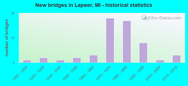
- New bridges - historical statistics
- 11920-1929
- 21930-1939
- 11940-1949
- 21950-1959
- 31960-1969
- 181970-1979
- 171980-1989
- 81990-1999
- 12000-2009
- 32010-2019

- Reconstructed bridges - Historical Statistics
- 11980-1989
- 11990-1999
- 12000-2009
- 12010-2019


- Bridge Condition - Deck
- 15.8%Very good
- 36.8%Good
- 31.6%Satisfactory
- 5.3%Fair
- 7.9%Poor
- 2.6%Serious

- Bridge Condition - Superstructure
- 21.1%Very good
- 26.3%Good
- 18.4%Satisfactory
- 26.3%Fair
- 5.3%Poor
- 2.6%Serious

- Bridge Condition - Substructure
- 31.6%Very good
- 34.2%Good
- 21.1%Satisfactory
- 13.2%Fair

- Bridge Condition - Channel
- 29.7%Very good
- 51.4%Good
- 13.5%Satisfactory
- 2.7%Fair
- 2.7%Poor

- Bridge Condition - Culverts
- 25.0%Very good
- 62.5%Good
- 12.5%Satisfactory
Find on map >> Show street view
Structure Number: 53, Location: 6.2 MI S OF GRAND MARAIS (Lat: 46.589900, Lng: -86.008808), Route carried "on" structure: State highway 77, Year Built: 1928, Status: Open, Structure Length: 0.70m (2.30ft), Average Daily Traffic: 406 (year 2007), Truck Traffic: 14%, Average Future Daily Traffic: 651 (year 2018), Design Load: H 15, Features Intersected: W BR SUCKER RIVER
Minimum Vertical Clearance: 30.48m (100.00ft), Kilometerpoint: 11.158, Lanes on structure: 2, Base Highway Network: Yes (Inventory Route: 113, Subroute: 7), Owner: State Highway Agency, Approaching Roadway Width: 10.1m (33.1ft), Material/Design: Concrete, Design/Construction: Tee Beam, Number Of Spans In Main Unit: 1, Length of Maximum Span: 7.0m (23.0ft), Curb-To-Curb Width: 9.8m (32.2ft), Out-to-Out Width: 10.4m (34.1ft)
Condition: Deck: Good, Superstructure: Fair, Substructure: Satisfactory, Channel: Good, Operating Rating: 63.8 metric tons, Method Used To Determine Operating Rating: Load Factor (LF) rating reported by rating factor (RF) method using MS18 loading, Inventory Rating: 38.2 metric tons, Method Used To Determine Inventory Rating: Load Factor (LF) rating reported by rating factor (RF) method using MS18 loading, Structural Evaluation: Somewhat better than minimum adequacy, Deck Geometry: Equal to present minimum criteria, Waterway Adequacy: Better than present minimum criteria, Approach Roadway Alignment: Better than present minimum criteria, Designated Inspection Frequency: Every 24 months, Inspection Date: September 2021, Deck Structure Type: Concrete Cast-file-Place, Wearing Surface/Protective System: Wearing Surface: Bituminous
Find on map >> Show street view
Structure Number: 1265, Location: 3.2 MI E OF M-66 (Lat: 42.287058, Lng: -85.120475), Route carried "on" structure: Interstate 94, Year Built: 1959, Status: Open, Structure Length: 3.57m (11.71ft), Average Daily Traffic: 22,400 (year 2010), Truck Traffic: 23%, Average Future Daily Traffic: 29,282 (year 2030), Design Load: HS 20, Features Intersected: 9 MILE ROAD
Minimum Vertical Clearance: 30.48m (100.00ft), Kilometerpoint: 15.540, Lanes on structure: 2, Lanes under structure: 2, Base Highway Network: Yes (Inventory Route: 129, Subroute: 6), Owner: State Highway Agency, Approaching Roadway Width: 11.7m (38.4ft), Skew: 1 degrees, Material/Design: Concrete, Design/Construction: Tee Beam, Number Of Spans In Main Unit: 3, Length of Maximum Span: 13.5m (44.3ft), Curb-To-Curb Width: 12.8m (42.0ft), Out-to-Out Width: 14.4m (47.2ft)
Condition: Deck: Poor, Superstructure: Fair, Substructure: Fair, Operating Rating: 61.3 metric tons, Method Used To Determine Operating Rating: Load Factor (LF), Inventory Rating: 36.7 metric tons, Method Used To Determine Inventory Rating: Load Factor (LF), Structural Evaluation: Somewhat better than minimum adequacy, Deck Geometry: Equal to present desirable criteria, Underclear: Somewhat better than minimum adequacy, Approach Roadway Alignment: Equal to present desirable criteria, Designated Inspection Frequency: Every 24 months, Other Special Inspection Frequency: Every 24 months, Inspection Date: August 2021, Other Special Inspection Date: August 2020, Deck Structure Type: Concrete Cast-file-Place, Wearing Surface/Protective System: Wearing Surface: Latex Concrete
Find on map >> Show street view
Structure Number: 53, Location: 0.1 MI S OF W GENESEE ST (Lat: 43.049269, Lng: -83.318511), Route carried "on" structure: State highway 24, Year Built: 2015, Status: Open, Structure Length: 1.33m (4.36ft), Average Daily Traffic: 28,600 (year 2013), Truck Traffic: 3%, Average Future Daily Traffic: 31,600 (year 2033), Design Load: Greater than HL93, Features Intersected: FARMER'S CREEK
Minimum Vertical Clearance: 30.48m (100.00ft), Kilometerpoint: 18.722, Lanes on structure: 5, Owner: State Highway Agency, Approaching Roadway Width: 19.8m (65.0ft), Material/Design: Concrete, Design/Construction: Culvert, Number Of Spans In Main Unit: 1, Length of Maximum Span: 12.8m (42.0ft), Curb or Sidewalk Widths: Left: 0.8m (2.6ft), Right: 0.8m (2.6ft), Curb-To-Curb Width: 18.3m (60.0ft), Out-to-Out Width: 33.1m (108.6ft)
Condition: Channel: Very good, Culverts: Very good, Operating Rating: 87.8 metric tons, Method Used To Determine Operating Rating: Load and Resistance Factor Rating (LRFR) rating reported by rating factor(RF) method using HL-93 loadings, Inventory Rating: 67.7 metric tons, Method Used To Determine Inventory Rating: Load and Resistance Factor Rating (LRFR) rating reported by rating factor(RF) method using HL-93 loadings, Structural Evaluation: Equal to present desirable criteria, Deck Geometry: High priority of replacement, Waterway Adequacy: Equal to present desirable criteria, Approach Roadway Alignment: Equal to present minimum criteria, Designated Inspection Frequency: Every 24 months, Inspection Date: November 2021, Wearing Surface/Protective System: Wearing Surface: Bituminous
Find on map >> Show street view
Structure Number: 5301, Location: 1.8 MI N OF M-21 (Lat: 43.080733, Lng: -83.310192), Route carried "on" structure: State highway 24, Year Built: 1948, Year Reconstructed: 1999, Status: Open, Structure Length: 1.98m (6.50ft), Average Daily Traffic: 18,440 (year 2007), Truck Traffic: 3%, Average Future Daily Traffic: 26,109 (year 2018), Design Load: HS 25 or greater, Features Intersected: S BR FLINT RIVER
Minimum Vertical Clearance: 30.48m (100.00ft), Kilometerpoint: 22.392, Lanes on structure: 2, Owner: State Highway Agency, Approaching Roadway Width: 11.6m (38.1ft), Material/Design: Steel, Design/Construction: Stringer/Multi-beam, Number Of Spans In Main Unit: 1, Length of Maximum Span: 18.7m (61.4ft), Curb-To-Curb Width: 13.1m (43.0ft), Out-to-Out Width: 13.8m (45.3ft)
Condition: Deck: Satisfactory, Superstructure: Fair, Substructure: Satisfactory, Channel: Satisfactory, Operating Rating: 97.2 metric tons, Method Used To Determine Operating Rating: Load Factor (LF) rating reported by rating factor (RF) method using MS18 loading, Inventory Rating: 70.3 metric tons, Method Used To Determine Inventory Rating: Load Factor (LF) rating reported by rating factor (RF) method using MS18 loading, Structural Evaluation: Somewhat better than minimum adequacy, Deck Geometry: Somewhat better than minimum adequacy, Waterway Adequacy: Equal to present desirable criteria, Approach Roadway Alignment: Equal to present desirable criteria, Designated Inspection Frequency: Every 24 months, Inspection Date: May 2021, Deck Structure Type: Concrete Cast-file-Place, Wearing Surface/Protective System: Wearing Surface: Monolithic Concrete, Deck Protection: Epoxy Coated Reinforcing
Find on map >> Show street view
Structure Number: 5302, Location: 2.8 MI N OF M-21 (Lat: 43.091672, Lng: -83.307692), Route carried "on" structure: State highway 24, Year Built: 2012, Status: Open, Structure Length: 1.28m (4.20ft), Average Daily Traffic: 18,300 (year 2012), Truck Traffic: 3%, Average Future Daily Traffic: 20,200 (year 2032), Design Load: Greater than HL93, Features Intersected: PLUM CREEK
Minimum Vertical Clearance: 30.48m (100.00ft), Kilometerpoint: 23.655, Lanes on structure: 2, Base Highway Network: Yes (Inventory Route: 75, Subroute: 10), Owner: State Highway Agency, Approaching Roadway Width: 12.2m (40.0ft), Material/Design: Prestressed concrete, Design/Construction: Box Beam or Girders - Single/Spread, Number Of Spans In Main Unit: 1, Length of Maximum Span: 11.9m (39.0ft), Curb-To-Curb Width: 13.4m (44.0ft), Out-to-Out Width: 14.3m (46.9ft)
Condition: Deck: Very good, Superstructure: Very good, Substructure: Very good, Channel: Good, Operating Rating: 51.2 metric tons, Method Used To Determine Operating Rating: Load and Resistance Factor Rating (LRFR) rating reported by rating factor(RF) method using HL-93 loadings, Inventory Rating: 34.0 metric tons, Method Used To Determine Inventory Rating: Load and Resistance Factor Rating (LRFR) rating reported by rating factor(RF) method using HL-93 loadings, Structural Evaluation: Equal to present desirable criteria, Deck Geometry: Equal to present minimum criteria, Waterway Adequacy: Better than present minimum criteria, Approach Roadway Alignment: Equal to present desirable criteria, Designated Inspection Frequency: Every 24 months, Inspection Date: May 2021, Deck Structure Type: Concrete Cast-file-Place, Wearing Surface/Protective System: Wearing Surface: Monolithic Concrete, Deck Protection: Epoxy Coated Reinforcing
Find on map >> Show street view
Structure Number: 5322, Location: IN LAPEER (OLD M-21) (Lat: 43.050925, Lng: -83.304039), Route carried "on" structure: City street , Year Built: 1997, Status: Open, Structure Length: 0.97m (3.18ft), Average Daily Traffic: 14,458 (year 1999), Truck Traffic: 4%, Average Future Daily Traffic: 16,627 (year 2014), Design Load: HS 20, Features Intersected: S BR FLINT R, Facility Carried by Structure: E IMLAY CITY RD
Minimum Vertical Clearance: 30.48m (100.00ft), Kilometerpoint: 13.860, Lanes on structure: 5, Owner: City or Municipal Highway Agency, Approaching Roadway Width: 22.6m (74.1ft), Skew: 1 degrees, Material/Design: Prestressed concrete, Design/Construction: Box Beam or Girders - Single/Spread, Number Of Spans In Main Unit: 1, Length of Maximum Span: 9.7m (31.8ft), Curb or Sidewalk Widths: Left: 1.6m (5.2ft), Right: 1.6m (5.2ft), Curb-To-Curb Width: 19.5m (64.0ft), Out-to-Out Width: 23.3m (76.4ft)
Condition: Deck: Good, Superstructure: Very good, Substructure: Very good, Channel: Very good, Operating Rating: 75.2 metric tons, Method Used To Determine Operating Rating: Load Factor (LF) rating reported by rating factor (RF) method using MS18 loading, Inventory Rating: 45.0 metric tons, Method Used To Determine Inventory Rating: Load Factor (LF) rating reported by rating factor (RF) method using MS18 loading, Structural Evaluation: Equal to present desirable criteria, Deck Geometry: Meets minimum limits, Waterway Adequacy: Equal to present minimum criteria, Approach Roadway Alignment: Equal to present minimum criteria, Designated Inspection Frequency: Every 24 months, Inspection Date: April 2020, Deck Structure Type: Concrete Cast-file-Place, Wearing Surface/Protective System: Wearing Surface: Monolithic Concrete, Deck Protection: Epoxy Coated Reinforcing
Find on map >> Show street view
Structure Number: 5324, Location: 1.0 MI SW OF LAPEER (Lat: 43.030950, Lng: -83.349019), Route carried "on" structure: Interstate 69, Year Built: 1971, Status: Open, Structure Length: 3.36m (11.02ft), Average Daily Traffic: 13,176 (year 2007), Truck Traffic: 22%, Average Future Daily Traffic: 17,095 (year 2018), Design Load: HS 20, Features Intersected: FARMERS CREEK
Minimum Vertical Clearance: 30.48m (100.00ft), Kilometerpoint: 9.227, Lanes on structure: 2, Base Highway Network: Yes (Inventory Route: 75, Subroute: 2), Owner: State Highway Agency, Approaching Roadway Width: 12.2m (40.0ft), Material/Design: Prestressed concrete, Design/Construction: Stringer/Multi-beam, Number Of Spans In Main Unit: 3, Length of Maximum Span: 11.3m (37.1ft), Curb-To-Curb Width: 11.9m (39.0ft), Out-to-Out Width: 13.1m (43.0ft)
Condition: Deck: Satisfactory, Superstructure: Good, Substructure: Fair, Channel: Satisfactory, Operating Rating: 83.5 metric tons, Method Used To Determine Operating Rating: Load Factor (LF), Inventory Rating: 50.0 metric tons, Method Used To Determine Inventory Rating: Load Factor (LF), Structural Evaluation: Somewhat better than minimum adequacy, Deck Geometry: Equal to present minimum criteria, Waterway Adequacy: Equal to present desirable criteria, Approach Roadway Alignment: Equal to present desirable criteria, Designated Inspection Frequency: Every 24 months, Inspection Date: January 2022, Deck Structure Type: Concrete Cast-file-Place, Wearing Surface/Protective System: Wearing Surface: Epoxy Overlay
Find on map >> Show street view
Structure Number: 5325, Location: 1.0 MI SW OF LAPEER (Lat: 43.031358, Lng: -83.348906), Route carried "on" structure: Interstate 69, Year Built: 1971, Status: Open, Structure Length: 3.36m (11.02ft), Average Daily Traffic: 13,176 (year 2007), Truck Traffic: 22%, Average Future Daily Traffic: 17,095 (year 2018), Design Load: HS 20, Features Intersected: FARMERS CREEK
Minimum Vertical Clearance: 30.48m (100.00ft), Kilometerpoint: 9.233, Lanes on structure: 2, Base Highway Network: Yes (Inventory Route: 75, Subroute: 10), Owner: State Highway Agency, Approaching Roadway Width: 12.2m (40.0ft), Material/Design: Prestressed concrete, Design/Construction: Stringer/Multi-beam, Number Of Spans In Main Unit: 3, Length of Maximum Span: 11.3m (37.1ft), Curb-To-Curb Width: 11.9m (39.0ft), Out-to-Out Width: 13.1m (43.0ft)
Condition: Deck: Satisfactory, Superstructure: Good, Substructure: Fair, Channel: Good, Operating Rating: 83.5 metric tons, Method Used To Determine Operating Rating: Load Factor (LF), Inventory Rating: 50.0 metric tons, Method Used To Determine Inventory Rating: Load Factor (LF), Structural Evaluation: Somewhat better than minimum adequacy, Deck Geometry: Equal to present minimum criteria, Waterway Adequacy: Better than present minimum criteria, Approach Roadway Alignment: Equal to present desirable criteria, Designated Inspection Frequency: Every 24 months, Inspection Date: January 2022, Deck Structure Type: Concrete Cast-file-Place, Wearing Surface/Protective System: Wearing Surface: Epoxy Overlay
Find on map >> Show street view
Structure Number: 533, Location: 3.0 MI SW OF LAPEER (Lat: 43.031167, Lng: -83.361469), Route carried "on" structure: County highway 4421, Year Built: 1971, Year Reconstructed: 2016, Status: Open, Structure Length: 8.05m (26.41ft), Average Daily Traffic: 9,540 (year 2015), Truck Traffic: 2%, Average Future Daily Traffic: 10,971 (year 2035), Design Load: H 20, Features Intersected: I-69, Facility Carried by Structure: LAKE NEPESSING RD
Minimum Vertical Clearance: 30.48m (100.00ft), Kilometerpoint: 2.197, Lanes on structure: 2, Lanes under structure: 4, Owner: State Highway Agency, Approaching Roadway Width: 12.5m (41.0ft), Material/Design: Steel continuous, Design/Construction: Stringer/Multi-beam, Number Of Spans In Main Unit: 2, Length of Maximum Span: 39.6m (129.9ft), Curb-To-Curb Width: 12.4m (40.7ft), Out-to-Out Width: 13.4m (44.0ft)
Condition: Deck: Very good, Superstructure: Good, Substructure: Good, Operating Rating: 65.8 metric tons, Method Used To Determine Operating Rating: Load Factor (LF) rating reported by rating factor (RF) method using MS18 loading, Inventory Rating: 39.5 metric tons, Method Used To Determine Inventory Rating: Load Factor (LF) rating reported by rating factor (RF) method using MS18 loading, Structural Evaluation: Better than present minimum criteria, Deck Geometry: Somewhat better than minimum adequacy, Underclear: Somewhat better than minimum adequacy, Approach Roadway Alignment: Equal to present minimum criteria, Designated Inspection Frequency: Every 24 months, Inspection Date: January 2021, Deck Structure Type: Concrete Cast-file-Place, Wearing Surface/Protective System: Wearing Surface: Monolithic Concrete, Deck Protection: Epoxy Coated Reinforcing
Find on map >> Show street view
Structure Number: 5332, Location: 1.0 MI S OF LAPEER , M-24 (Lat: 43.024283, Lng: -83.322511), Route carried "on" structure: Interstate 69, Year Built: 1971, Status: Open, Structure Length: 5.21m (17.09ft), Average Daily Traffic: 13,176 (year 2007), Truck Traffic: 18%, Average Future Daily Traffic: 14,061 (year 2018), Design Load: HS 20, Features Intersected: M-24
Minimum Vertical Clearance: 30.48m (100.00ft), Kilometerpoint: 11.539, Lanes on structure: 3, Lanes under structure: 6, Base Highway Network: Yes (Inventory Route: 75, Subroute: 2), Owner: State Highway Agency, Approaching Roadway Width: 14.5m (47.6ft), Material/Design: Steel, Design/Construction: Stringer/Multi-beam, Number Of Spans In Main Unit: 2, Length of Maximum Span: 26.5m (86.9ft), Curb-To-Curb Width: 14.8m (48.6ft), Out-to-Out Width: 16.0m (52.5ft)
Condition: Deck: Good, Superstructure: Satisfactory, Substructure: Satisfactory, Operating Rating: 64.8 metric tons, Method Used To Determine Operating Rating: Load Factor (LF), Inventory Rating: 38.8 metric tons, Method Used To Determine Inventory Rating: Load Factor (LF), Structural Evaluation: Equal to present minimum criteria, Deck Geometry: Meets minimum limits, Underclear: Meets minimum limits, Approach Roadway Alignment: Equal to present desirable criteria, Designated Inspection Frequency: Every 24 months, Inspection Date: May 2021, Deck Structure Type: Concrete Cast-file-Place, Wearing Surface/Protective System: Wearing Surface: Epoxy Overlay
Find on map >> Show street view
Structure Number: 5335, Location: SE OF LAPEER (Lat: 43.011786, Lng: -83.265536), Route carried "on" structure: Interstate 69, Year Built: 1983, Status: Open, Structure Length: 4.20m (13.78ft), Average Daily Traffic: 12,398 (year 2007), Truck Traffic: 18%, Average Future Daily Traffic: 14,061 (year 2018), Design Load: HS 25 or greater, Features Intersected: S BR FLINT RIVER
Minimum Vertical Clearance: 30.48m (100.00ft), Kilometerpoint: 16.591, Lanes on structure: 2, Base Highway Network: Yes (Inventory Route: 75, Subroute: 10), Owner: State Highway Agency, Approaching Roadway Width: 13.7m (44.9ft), Skew: 2 degrees, Material/Design: Prestressed concrete, Design/Construction: Stringer/Multi-beam, Number Of Spans In Main Unit: 3, Length of Maximum Span: 19.5m (64.0ft), Curb-To-Curb Width: 13.4m (44.0ft), Out-to-Out Width: 14.7m (48.2ft)
Condition: Deck: Satisfactory, Superstructure: Fair, Substructure: Satisfactory, Channel: Good, Operating Rating: 52.5 metric tons, Method Used To Determine Operating Rating: Load Factor (LF) rating reported by rating factor (RF) method using MS18 loading, Inventory Rating: 31.4 metric tons, Method Used To Determine Inventory Rating: Load Factor (LF) rating reported by rating factor (RF) method using MS18 loading, Structural Evaluation: Somewhat better than minimum adequacy, Deck Geometry: Superior to present desirable criteria, Waterway Adequacy: Equal to present desirable criteria, Approach Roadway Alignment: Equal to present desirable criteria, Designated Inspection Frequency: Every 24 months, Inspection Date: May 2021, Deck Structure Type: Concrete Cast-file-Place, Wearing Surface/Protective System: Wearing Surface: Latex Concrete, Deck Protection: Epoxy Coated Reinforcing
Find on map >> Show street view
Structure Number: 5337, Location: S OF LAPEER (Lat: 43.024750, Lng: -83.316256), Route carried "on" structure: Interstate 69, Year Built: 1983, Status: Open, Structure Length: 3.75m (12.30ft), Average Daily Traffic: 12,398 (year 2007), Truck Traffic: 18%, Average Future Daily Traffic: 14,061 (year 2018), Design Load: HS 25 or greater, Features Intersected: HUNTER CREEK
Minimum Vertical Clearance: 30.48m (100.00ft), Kilometerpoint: 12.046, Lanes on structure: 3, Base Highway Network: Yes (Inventory Route: 75, Subroute: 10), Owner: State Highway Agency, Approaching Roadway Width: 21.6m (70.9ft), Material/Design: Prestressed concrete, Design/Construction: Stringer/Multi-beam, Number Of Spans In Main Unit: 3, Length of Maximum Span: 12.5m (41.0ft), Curb-To-Curb Width: 20.3m (66.6ft), Out-to-Out Width: 21.5m (70.5ft)
Condition: Deck: Good, Superstructure: Fair, Substructure: Good, Channel: Satisfactory, Operating Rating: 75.4 metric tons, Method Used To Determine Operating Rating: Load Factor (LF), Inventory Rating: 45.2 metric tons, Method Used To Determine Inventory Rating: Load Factor (LF), Structural Evaluation: Somewhat better than minimum adequacy, Deck Geometry: Superior to present desirable criteria, Waterway Adequacy: Equal to present desirable criteria, Approach Roadway Alignment: Equal to present desirable criteria, Designated Inspection Frequency: Every 24 months, Inspection Date: May 2021, Deck Structure Type: Concrete Cast-file-Place, Wearing Surface/Protective System: Wearing Surface: Epoxy Overlay, Deck Protection: Epoxy Coated Reinforcing
Find on map >> Show street view
Structure Number: 5339, Location: 0.2 MI E OF WILDER RD (Lat: 43.009836, Lng: -83.240986), Route carried "on" structure: Interstate 69, Year Built: 1983, Status: Open, Structure Length: 0.76m (2.49ft), Average Daily Traffic: 22,572 (year 2007), Truck Traffic: 17%, Average Future Daily Traffic: 39,025 (year 2018), Design Load: HS 20+Mod, Features Intersected: PINE CREEK
Minimum Vertical Clearance: 30.48m (100.00ft), Kilometerpoint: 18.608, Lanes on structure: 4, Base Highway Network: Yes (Inventory Route: 75, Subroute: 2), Owner: State Highway Agency, Approaching Roadway Width: 13.7m (44.9ft), Material/Design: Concrete, Design/Construction: Culvert, Number Of Spans In Main Unit: 2, Length of Maximum Span: 3.6m (11.8ft), Curb-To-Curb Width: 13.7m (44.9ft), Out-to-Out Width: 25.5m (83.7ft)
Condition: Channel: Poor, Culverts: Good, Operating Rating: 58.6 metric tons, Method Used To Determine Operating Rating: Load Factor (LF) rating reported by rating factor (RF) method using MS18 loading, Inventory Rating: 35.3 metric tons, Method Used To Determine Inventory Rating: Load Factor (LF) rating reported by rating factor (RF) method using MS18 loading, Structural Evaluation: Better than present minimum criteria, Deck Geometry: High priority of replacement, Waterway Adequacy: Better than present minimum criteria, Approach Roadway Alignment: Equal to present desirable criteria, Designated Inspection Frequency: Every 24 months, Inspection Date: May 2021, Deck Structure Type: Concrete Cast-file-Place, Wearing Surface/Protective System: Wearing Surface: Monolithic Concrete, Deck Protection: Epoxy Coated Reinforcing
Find on map >> Show street view
Structure Number: 5344, Location: 1.0 MI S OF LAPEER (Lat: 43.023075, Lng: -83.302711), Route carried "on" structure: Interstate 69, Year Built: 1983, Status: Open, Structure Length: 2.99m (9.81ft), Average Daily Traffic: 9,991 (year 2013), Truck Traffic: 18%, Average Future Daily Traffic: 11,489 (year 2033), Design Load: HS 25 or greater, Features Intersected: CLARK RD
Minimum Vertical Clearance: 30.48m (100.00ft), Kilometerpoint: 13.173, Lanes on structure: 2, Lanes under structure: 2, Base Highway Network: Yes (Inventory Route: 75, Subroute: 2), Owner: State Highway Agency, Approaching Roadway Width: 14.6m (47.9ft), Skew: 2 degrees, Material/Design: Steel, Design/Construction: Stringer/Multi-beam, Number Of Spans In Main Unit: 1, Length of Maximum Span: 28.8m (94.5ft), Curb-To-Curb Width: 13.5m (44.3ft), Out-to-Out Width: 14.7m (48.2ft)
Condition: Deck: Satisfactory, Superstructure: Fair, Substructure: Very good, Operating Rating: 86.5 metric tons, Method Used To Determine Operating Rating: Load Factor (LF) rating reported by rating factor (RF) method using MS18 loading, Inventory Rating: 51.8 metric tons, Method Used To Determine Inventory Rating: Load Factor (LF) rating reported by rating factor (RF) method using MS18 loading, Structural Evaluation: Somewhat better than minimum adequacy, Deck Geometry: Superior to present desirable criteria, Underclear: Somewhat better than minimum adequacy, Approach Roadway Alignment: Equal to present desirable criteria, Designated Inspection Frequency: Every 24 months, Inspection Date: April 2021, Deck Structure Type: Concrete Cast-file-Place, Wearing Surface/Protective System: Wearing Surface: Epoxy Overlay, Deck Protection: Epoxy Coated Reinforcing
Find on map >> Show street view
Structure Number: 5345, Location: 1.0 MI S OF LAPEER (Lat: 43.023450, Lng: -83.302742), Route carried "on" structure: Interstate 69, Year Built: 1983, Status: Open, Structure Length: 2.99m (9.81ft), Average Daily Traffic: 9,991 (year 2013), Truck Traffic: 18%, Average Future Daily Traffic: 11,489 (year 2033), Design Load: HS 25 or greater, Features Intersected: CLARK RD
Minimum Vertical Clearance: 30.48m (100.00ft), Kilometerpoint: 13.167, Lanes on structure: 2, Lanes under structure: 2, Base Highway Network: Yes (Inventory Route: 75, Subroute: 10), Owner: State Highway Agency, Approaching Roadway Width: 14.6m (47.9ft), Skew: 2 degrees, Material/Design: Steel, Design/Construction: Stringer/Multi-beam, Number Of Spans In Main Unit: 1, Length of Maximum Span: 28.8m (94.5ft), Curb-To-Curb Width: 13.5m (44.3ft), Out-to-Out Width: 14.7m (48.2ft)
Condition: Deck: Good, Superstructure: Very good, Substructure: Very good, Operating Rating: 86.5 metric tons, Method Used To Determine Operating Rating: Load Factor (LF) rating reported by rating factor (RF) method using MS18 loading, Inventory Rating: 51.8 metric tons, Method Used To Determine Inventory Rating: Load Factor (LF) rating reported by rating factor (RF) method using MS18 loading, Structural Evaluation: Equal to present desirable criteria, Deck Geometry: Superior to present desirable criteria, Underclear: Somewhat better than minimum adequacy, Approach Roadway Alignment: Equal to present desirable criteria, Designated Inspection Frequency: Every 24 months, Inspection Date: April 2021, Deck Structure Type: Concrete Cast-file-Place, Wearing Surface/Protective System: Wearing Surface: Epoxy Overlay, Deck Protection: Epoxy Coated Reinforcing
Find on map >> Show street view
Structure Number: 5346, Location: 0.7 MI E OF LAPEER (Lat: 43.012808, Lng: -83.282550), Route carried "on" structure: County highway , Year Built: 1983, Status: Open, Structure Length: 9.14m (29.99ft), Average Daily Traffic: 1,090 (year 1997), Truck Traffic: 3%, Average Future Daily Traffic: 1,500 (year 2016), Design Load: HS 20, Features Intersected: I-69, Facility Carried by Structure: MORRIS RD
Minimum Vertical Clearance: 30.48m (100.00ft), Kilometerpoint: 2.977, Lanes on structure: 2, Lanes under structure: 4, Owner: State Highway Agency, Approaching Roadway Width: 11.2m (36.7ft), Skew: 2 degrees, Material/Design: Steel continuous, Design/Construction: Stringer/Multi-beam, Number Of Spans In Main Unit: 2, Length of Maximum Span: 45.7m (149.9ft), Curb-To-Curb Width: 11.0m (36.1ft), Out-to-Out Width: 12.2m (40.0ft)
Condition: Deck: Satisfactory, Superstructure: Satisfactory, Substructure: Good, Operating Rating: 63.8 metric tons, Method Used To Determine Operating Rating: Load Factor (LF) rating reported by rating factor (RF) method using MS18 loading, Inventory Rating: 38.2 metric tons, Method Used To Determine Inventory Rating: Load Factor (LF) rating reported by rating factor (RF) method using MS18 loading, Structural Evaluation: Equal to present minimum criteria, Deck Geometry: Equal to present minimum criteria, Underclear: Somewhat better than minimum adequacy, Approach Roadway Alignment: Equal to present desirable criteria, Designated Inspection Frequency: Every 24 months, Inspection Date: April 2021, Deck Structure Type: Concrete Cast-file-Place, Wearing Surface/Protective System: Wearing Surface: Epoxy Overlay, Deck Protection: Epoxy Coated Reinforcing
Find on map >> Show street view
Structure Number: 5347, Location: 3.0 MI E OF LAPEER (Lat: 43.009550, Lng: -83.243322), Route carried "on" structure: County highway 4445, Year Built: 1983, Status: Open, Structure Length: 8.29m (27.20ft), Average Daily Traffic: 1,870 (year 1997), Truck Traffic: 3%, Average Future Daily Traffic: 1,500 (year 2016), Design Load: HS 20, Features Intersected: I-69, Facility Carried by Structure: WILDER RD
Minimum Vertical Clearance: 30.48m (100.00ft), Kilometerpoint: 4.131, Lanes on structure: 2, Lanes under structure: 4, Owner: State Highway Agency, Approaching Roadway Width: 14.6m (47.9ft), Material/Design: Steel continuous, Design/Construction: Stringer/Multi-beam, Number Of Spans In Main Unit: 2, Length of Maximum Span: 40.8m (133.9ft), Curb-To-Curb Width: 12.8m (42.0ft), Out-to-Out Width: 14.0m (45.9ft)
Condition: Deck: Satisfactory, Superstructure: Very good, Substructure: Very good, Operating Rating: 54.4 metric tons, Method Used To Determine Operating Rating: Load Factor (LF) rating reported by rating factor (RF) method using MS18 loading, Inventory Rating: 32.7 metric tons, Method Used To Determine Inventory Rating: Load Factor (LF) rating reported by rating factor (RF) method using MS18 loading, Structural Evaluation: Equal to present desirable criteria, Deck Geometry: Better than present minimum criteria, Underclear: Somewhat better than minimum adequacy, Approach Roadway Alignment: Equal to present desirable criteria, Designated Inspection Frequency: Every 24 months, Inspection Date: April 2021, Deck Structure Type: Concrete Cast-file-Place, Wearing Surface/Protective System: Wearing Surface: Epoxy Overlay, Deck Protection: Epoxy Coated Reinforcing
Find on map >> Show street view
Structure Number: 5369, Location: SEC 23-26 LAPEER TWP (Lat: 43.001125, Lng: -83.252603), Route carried "on" structure: County highway , Year Built: 1994, Status: Open, Structure Length: 1.34m (4.40ft), Average Daily Traffic: 1,887 (year 2020), Truck Traffic: 3%, Average Future Daily Traffic: 2,303 (year 2040), Design Load: HS 20+Mod, Features Intersected: SOUTH BR FLINT RIVER, Facility Carried by Structure: NEWARK ROAD
Minimum Vertical Clearance: 30.48m (100.00ft), Kilometerpoint: 5.589, Lanes on structure: 2, Owner: County Highway Agency, Approaching Roadway Width: 12.2m (40.0ft), Material/Design: Prestressed concrete, Design/Construction: Box Beam or Girders - Multiple, Number Of Spans In Main Unit: 1, Length of Maximum Span: 12.2m (40.0ft), Curb-To-Curb Width: 12.5m (41.0ft), Out-to-Out Width: 13.2m (43.3ft)
Condition: Deck: Good, Superstructure: Good, Substructure: Good, Channel: Good, Operating Rating: 84.9 metric tons, Method Used To Determine Operating Rating: Load Factor (LF) rating reported by rating factor (RF) method using MS18 loading, Inventory Rating: 50.9 metric tons, Method Used To Determine Inventory Rating: Load Factor (LF) rating reported by rating factor (RF) method using MS18 loading, Structural Evaluation: Better than present minimum criteria, Deck Geometry: Better than present minimum criteria, Waterway Adequacy: Equal to present desirable criteria, Approach Roadway Alignment: Equal to present desirable criteria, Designated Inspection Frequency: Every 24 months, Inspection Date: July 2021, Deck Structure Type: Concrete Cast-file-Place, Wearing Surface/Protective System: Wearing Surface: Bituminous
Find on map >> Show street view
Structure Number: 537, Location: SEC. 13-24 ELBA TWP. (Lat: 43.013981, Lng: -83.351108), Route carried "on" structure: County highway 4430, Year Built: 1963, Status: Open, Structure Length: 1.52m (4.99ft), Average Daily Traffic: 2,309 (year 2020), Truck Traffic: 5%, Average Future Daily Traffic: 2,817 (year 2040), Design Load: H 15, Features Intersected: FARMERS CREEK, Facility Carried by Structure: LIPPINCOTT ROAD
Minimum Vertical Clearance: 30.48m (100.00ft), Kilometerpoint: 9.064, Lanes on structure: 2, Owner: County Highway Agency, Approaching Roadway Width: 8.5m (27.9ft), Material/Design: Steel, Design/Construction: Stringer/Multi-beam, Number Of Spans In Main Unit: 1, Length of Maximum Span: 14.6m (47.9ft), Curb-To-Curb Width: 8.4m (27.6ft), Out-to-Out Width: 8.9m (29.2ft)
Condition: Deck: Fair, Superstructure: Fair, Substructure: Good, Channel: Good, Operating Rating: 53.1 metric tons, Method Used To Determine Operating Rating: Load Factor (LF) rating reported by rating factor (RF) method using MS18 loading, Inventory Rating: 31.8 metric tons, Method Used To Determine Inventory Rating: Load Factor (LF) rating reported by rating factor (RF) method using MS18 loading, Structural Evaluation: Somewhat better than minimum adequacy, Deck Geometry: High priority of corrective action, Waterway Adequacy: Equal to present desirable criteria, Approach Roadway Alignment: Better than present minimum criteria, Designated Inspection Frequency: Every 24 months, Inspection Date: June 2020, Deck Structure Type: Concrete Cast-file-Place, Wearing Surface/Protective System: Wearing Surface: Epoxy Overlay
Find on map >> Show street view
Structure Number: 5372, Location: SEC. 11 ELBA TWP. (Lat: 43.038997, Lng: -83.375911), Route carried "on" structure: County highway 4432, Year Built: 2003, Status: Posted for load, Structure Length: 6.43m (21.10ft), Average Daily Traffic: 2,007 (year 2020), Truck Traffic: 5%, Average Future Daily Traffic: 2,449 (year 2040), Design Load: HS 20, Features Intersected: CN NORTH AMERICA, Facility Carried by Structure: GENESEE ROAD
Minimum Vertical Clearance: 30.48m (100.00ft), Kilometerpoint: 7.258, Lanes on structure: 2, Owner: County Highway Agency, Approaching Roadway Width: 12.2m (40.0ft), Skew: 4 degrees, Material/Design: Prestressed concrete, Design/Construction: Box Beam or Girders - Multiple, Number Of Spans In Main Unit: 3, Length of Maximum Span: 24.1m (79.1ft), Curb-To-Curb Width: 12.2m (40.0ft), Out-to-Out Width: 13.3m (43.6ft)
Condition: Deck: Very good, Superstructure: Very good, Substructure: Very good, Operating Rating: 36.6 metric tons, Method Used To Determine Operating Rating: Load Factor (LF) rating reported by rating factor (RF) method using MS18 loading, Inventory Rating: 22.0 metric tons, Method Used To Determine Inventory Rating: Load Factor (LF) rating reported by rating factor (RF) method using MS18 loading, Structural Evaluation: Somewhat better than minimum adequacy, Deck Geometry: Equal to present minimum criteria, Approach Roadway Alignment: Better than present minimum criteria, Bridge Posting: Required (Relationship of Operating Rating to Maximum Legal Load: 20.0 - 29.9% below), Designated Inspection Frequency: Every 24 months, Inspection Date: June 2021, Deck Structure Type: Concrete Precast Panels, Wearing Surface/Protective System: Wearing Surface: Monolithic Concrete, Deck Protection: Epoxy Coated Reinforcing
Find on map >> Show street view
Structure Number: 5373, Location: SEC. 21-28 MAYFIELD TWP. (Lat: 43.087858, Lng: -83.295617), Route carried "on" structure: County highway 4448, Year Built: 1976, Status: Open, Structure Length: 1.06m (3.48ft), Average Daily Traffic: 2,713 (year 2020), Average Future Daily Traffic: 3,310 (year 2040), Design Load: H 20, Features Intersected: PLUM CREEK DRAIN, Facility Carried by Structure: DALEY ROAD
Minimum Vertical Clearance: 30.48m (100.00ft), Kilometerpoint: 0.964, Lanes on structure: 2, Owner: County Highway Agency, Approaching Roadway Width: 9.1m (29.9ft), Skew: 3 degrees, Material/Design: Steel, Design/Construction: Culvert, Number Of Spans In Main Unit: 2, Length of Maximum Span: 3.6m (11.8ft)
Condition: Channel: Satisfactory, Culverts: Good, Operating Rating: 97.2 metric tons, Method Used To Determine Operating Rating: Load Factor (LF) rating reported by rating factor (RF) method using MS18 loading, Inventory Rating: 58.6 metric tons, Method Used To Determine Inventory Rating: Load Factor (LF) rating reported by rating factor (RF) method using MS18 loading, Structural Evaluation: Better than present minimum criteria, Waterway Adequacy: Equal to present desirable criteria, Approach Roadway Alignment: Equal to present desirable criteria, Designated Inspection Frequency: Every 24 months, Inspection Date: July 2021
Find on map >> Show street view
Structure Number: 5388, Location: SEC. 5 ELBA TWP. (Lat: 43.042297, Lng: -83.422992), Route carried "on" structure: County highway 4434, Year Built: 1993, Status: Open, Structure Length: 1.22m (4.00ft), Average Daily Traffic: 5,780 (year 2020), Average Future Daily Traffic: 7,053 (year 2040), Design Load: HS 20+Mod, Features Intersected: HASLER CREEK DRAIN, Facility Carried by Structure: DAVISON ROAD
Minimum Vertical Clearance: 30.48m (100.00ft), Kilometerpoint: 3.941, Lanes on structure: 2, Owner: County Highway Agency, Approaching Roadway Width: 12.2m (40.0ft), Skew: 3 degrees, Material/Design: Prestressed concrete, Design/Construction: Tee Beam, Number Of Spans In Main Unit: 1, Length of Maximum Span: 11.2m (36.7ft), Curb-To-Curb Width: 12.2m (40.0ft), Out-to-Out Width: 13.1m (43.0ft)
Condition: Deck: Good, Superstructure: Good, Substructure: Satisfactory, Channel: Very good, Operating Rating: 45.0 metric tons, Method Used To Determine Operating Rating: Load Factor (LF) rating reported by rating factor (RF) method using MS18 loading, Inventory Rating: 26.9 metric tons, Method Used To Determine Inventory Rating: Load Factor (LF) rating reported by rating factor (RF) method using MS18 loading, Structural Evaluation: Equal to present minimum criteria, Deck Geometry: Somewhat better than minimum adequacy, Waterway Adequacy: Equal to present minimum criteria, Approach Roadway Alignment: Equal to present desirable criteria, Designated Inspection Frequency: Every 24 months, Inspection Date: June 2021, Deck Structure Type: Concrete Cast-file-Place, Wearing Surface/Protective System: Wearing Surface: Bituminous, Membrane: Preformed Fabric, Deck Protection: Epoxy Coated Reinforcing
Find on map >> Show street view
Structure Number: 5389, Location: SEC. 28-29 MAYFIELD TWP. (Lat: 43.078714, Lng: -83.306794), Route carried "on" structure: County highway 4433, Year Built: 1935, Year Reconstructed: 2021, Status: Open, Structure Length: 1.26m (4.13ft), Average Daily Traffic: 5,200 (year 2021), Truck Traffic: 10%, Average Future Daily Traffic: 9,392 (year 2041), Design Load: H 15, Features Intersected: SOUTH BR. FLINT RIVER, Facility Carried by Structure: SAGINAW ROAD
Minimum Vertical Clearance: 30.48m (100.00ft), Kilometerpoint: 12.174, Lanes on structure: 2, Owner: County Highway Agency, Approaching Roadway Width: 11.6m (38.1ft), Material/Design: Steel, Design/Construction: Stringer/Multi-beam, Number Of Spans In Main Unit: 1, Length of Maximum Span: 11.2m (36.7ft), Curb-To-Curb Width: 11.6m (38.1ft), Out-to-Out Width: 12.3m (40.4ft)
Condition: Deck: Very good, Superstructure: Very good, Substructure: Very good, Channel: Very good, Operating Rating: 52.2 metric tons, Method Used To Determine Operating Rating: Load and Resistance Factor Rating (LRFR) rating reported by rating factor(RF) method using HL-93 loadings, Inventory Rating: 40.2 metric tons, Method Used To Determine Inventory Rating: Load and Resistance Factor Rating (LRFR) rating reported by rating factor(RF) method using HL-93 loadings, Structural Evaluation: Equal to present desirable criteria, Deck Geometry: Somewhat better than minimum adequacy, Waterway Adequacy: Equal to present desirable criteria, Approach Roadway Alignment: Better than present minimum criteria, Designated Inspection Frequency: Every 22 months, Inspection Date: November 2021, Deck Structure Type: Concrete Cast-file-Place, Wearing Surface/Protective System: Wearing Surface: Monolithic Concrete, Deck Protection: Epoxy Coated Reinforcing
Find on map >> Show street view
Structure Number: 539, Location: SEC. 11-12 LAPEER TWP. (Lat: 43.041178, Lng: -83.245197), Route carried "on" structure: County highway 4445, Year Built: 2017, Status: Open, Structure Length: 0.67m (2.20ft), Average Daily Traffic: 3,415 (year 2019), Average Future Daily Traffic: 4,167 (year 2039), Design Load: H 20, Features Intersected: PINE CREEK DRAIN, Facility Carried by Structure: WILDER ROAD
Minimum Vertical Clearance: 30.48m (100.00ft), Kilometerpoint: 7.646, Lanes on structure: 2, Owner: County Highway Agency, Approaching Roadway Width: 10.4m (34.1ft), Material/Design: Aluminum, Iron, Design/Construction: Culvert, Number Of Spans In Main Unit: 1, Length of Maximum Span: 6.7m (22.0ft), Out-to-Out Width: 18.4m (60.4ft)
Condition: Channel: Good, Culverts: Good, Operating Rating: 45.0 metric tons, Method Used To Determine Operating Rating: Load and Resistance Factor Rating (LRFR) rating reported by rating factor(RF) method using HL-93 loadings, Inventory Rating: 35.0 metric tons, Method Used To Determine Inventory Rating: Load and Resistance Factor Rating (LRFR) rating reported by rating factor(RF) method using HL-93 loadings, Structural Evaluation: Better than present minimum criteria, Waterway Adequacy: Equal to present desirable criteria, Approach Roadway Alignment: Equal to present desirable criteria, Designated Inspection Frequency: Every 24 months, Inspection Date: July 2021
Find on map >> Show street view
Structure Number: 5421, Location: SEC. 35 ELBA TWP. (Lat: 42.977314, Lng: -83.362514), Route carried "on" structure: ServiceCounty highway , Year Built: 1985, Status: Posted for load, Structure Length: 0.73m (2.40ft), Average Daily Traffic: 25 (year 2020), Truck Traffic: 6%, Average Future Daily Traffic: 31 (year 2040), Design Load: HS 20, Features Intersected: FARMERS CREEK, Facility Carried by Structure: MITCHELL ROAD
Minimum Vertical Clearance: 30.48m (100.00ft), Kilometerpoint: 1.325, Lanes on structure: 2, Owner: County Highway Agency, Approaching Roadway Width: 7.3m (24.0ft), Material/Design: Wood or Timber, Design/Construction: Slab, Number Of Spans In Main Unit: 1, Length of Maximum Span: 6.7m (22.0ft), Curb-To-Curb Width: 8.5m (27.9ft), Out-to-Out Width: 9.0m (29.5ft)
Condition: Deck: Satisfactory, Superstructure: Satisfactory, Substructure: Satisfactory, Channel: Very good, Operating Rating: 40.2 metric tons, Method Used To Determine Operating Rating: Allowable Stress (AS) rating reported by rating factor (RF) method using MS18 loading, Inventory Rating: 27.5 metric tons, Method Used To Determine Inventory Rating: Allowable Stress (AS) rating reported by rating factor (RF) method using MS18 loading, Structural Evaluation: Equal to present minimum criteria, Deck Geometry: Better than present minimum criteria, Waterway Adequacy: Equal to present desirable criteria, Approach Roadway Alignment: Better than present minimum criteria, Bridge Posting: Required (Relationship of Operating Rating to Maximum Legal Load: 10.0 - 19.9% below), Designated Inspection Frequency: Every 24 months, Inspection Date: June 2021, Deck Structure Type: Wood or Timber, Wearing Surface/Protective System: Wearing Surface: Bituminous, Deck Protection: Other
Find on map >> Show street view
Structure Number: 5433, Location: SEC. 14-23 LAPEER TWP. (Lat: 43.015486, Lng: -83.259825), Route carried "on" structure: County highway , Year Built: 1981, Status: Open, Structure Length: 1.22m (4.00ft), Average Daily Traffic: 215 (year 2018), Average Future Daily Traffic: 262 (year 2038), Design Load: HS 20, Features Intersected: SOUTH BR. FLINT RIVER, Facility Carried by Structure: GREENWOOD ROAD
Minimum Vertical Clearance: 30.48m (100.00ft), Kilometerpoint: 1.859, Lanes on structure: 2, Owner: County Highway Agency, Approaching Roadway Width: 6.1m (20.0ft), Material/Design: Prestressed concrete, Design/Construction: Box Beam or Girders - Multiple, Number Of Spans In Main Unit: 1, Length of Maximum Span: 11.5m (37.7ft), Curb-To-Curb Width: 9.4m (30.8ft), Out-to-Out Width: 9.4m (30.8ft)
Condition: Deck: Good, Superstructure: Good, Substructure: Good, Channel: Good, Operating Rating: 56.4 metric tons, Method Used To Determine Operating Rating: Load Factor (LF) rating reported by rating factor (RF) method using MS18 loading, Inventory Rating: 33.7 metric tons, Method Used To Determine Inventory Rating: Load Factor (LF) rating reported by rating factor (RF) method using MS18 loading, Structural Evaluation: Better than present minimum criteria, Deck Geometry: Equal to present minimum criteria, Waterway Adequacy: Equal to present desirable criteria, Approach Roadway Alignment: Equal to present minimum criteria, Designated Inspection Frequency: Every 24 months, Inspection Date: July 2021, Deck Structure Type: Concrete Precast Panels, Wearing Surface/Protective System: Wearing Surface: Bituminous, Deck Protection: Epoxy Coated Reinforcing
Find on map >> Show street view
Structure Number: 5434, Location: SEC. 15 LAPEER TWP. (Lat: 43.022461, Lng: -83.265292), Route carried "on" structure: ServiceCounty highway , Year Built: 1977, Status: Temporarily open, Structure Length: 0.91m (2.99ft), Average Daily Traffic: 420 (year 2005), Average Future Daily Traffic: 750 (year 2027), Design Load: HS 20, Features Intersected: SOUTH BR. FLINT RIVER, Facility Carried by Structure: HIGLEY ROAD
Minimum Vertical Clearance: 30.48m (100.00ft), Kilometerpoint: 3.121, Lanes on structure: 2, Owner: County Highway Agency, Approaching Roadway Width: 6.1m (20.0ft), Material/Design: Prestressed concrete, Design/Construction: Box Beam or Girders - Multiple, Number Of Spans In Main Unit: 1, Length of Maximum Span: 8.8m (28.9ft), Curb-To-Curb Width: 7.3m (24.0ft), Out-to-Out Width: 7.4m (24.3ft)
Condition: Deck: Satisfactory, Superstructure: Fair, Substructure: Fair, Channel: Good, Operating Rating: 59.3 metric tons, Method Used To Determine Operating Rating: Load Factor (LF) rating reported by rating factor (RF) method using MS18 loading, Inventory Rating: 35.6 metric tons, Method Used To Determine Inventory Rating: Load Factor (LF) rating reported by rating factor (RF) method using MS18 loading, Structural Evaluation: Somewhat better than minimum adequacy, Deck Geometry: Meets minimum limits, Waterway Adequacy: Equal to present desirable criteria, Approach Roadway Alignment: Equal to present minimum criteria, Designated Inspection Frequency: Every 24 months, Inspection Date: July 2021, Deck Structure Type: Concrete Precast Panels, Wearing Surface/Protective System: Wearing Surface: Bituminous
Find on map >> Show street view
Structure Number: 5435, Location: SEC. 10 LAPEER TWP. (Lat: 43.036961, Lng: -83.277978), Route carried "on" structure: ServiceCounty highway , Year Built: 1991, Status: Posted for load, Structure Length: 1.52m (4.99ft), Average Daily Traffic: 616 (year 2020), Average Future Daily Traffic: 752 (year 2040), Design Load: HS 20, Features Intersected: SOUTH BR. FLINT RIVER, Facility Carried by Structure: PEPPERMILL ROAD
Minimum Vertical Clearance: 30.48m (100.00ft), Kilometerpoint: 0.489, Lanes on structure: 2, Owner: County Highway Agency, Approaching Roadway Width: 7.3m (24.0ft), Material/Design: Prestressed concrete, Design/Construction: Tee Beam, Number Of Spans In Main Unit: 1, Length of Maximum Span: 14.3m (46.9ft), Curb-To-Curb Width: 9.1m (29.9ft), Out-to-Out Width: 10.1m (33.1ft)
Condition: Deck: Satisfactory, Superstructure: Satisfactory, Substructure: Good, Channel: Very good, Operating Rating: 44.7 metric tons, Method Used To Determine Operating Rating: Load Factor (LF) rating reported by rating factor (RF) method using MS18 loading, Inventory Rating: 26.9 metric tons, Method Used To Determine Inventory Rating: Load Factor (LF) rating reported by rating factor (RF) method using MS18 loading, Structural Evaluation: Equal to present minimum criteria, Deck Geometry: Equal to present minimum criteria, Waterway Adequacy: Better than present minimum criteria, Approach Roadway Alignment: Equal to present minimum criteria, Bridge Posting: Required (Relationship of Operating Rating to Maximum Legal Load: 10.0 - 19.9% below), Designated Inspection Frequency: Every 24 months, Inspection Date: July 2021, Deck Structure Type: Concrete Precast Panels, Wearing Surface/Protective System: Wearing Surface: Bituminous
Find on map >> Show street view
Structure Number: 5436, Location: SEC. 4-9 LAPEER TWP. (Lat: 43.044025, Lng: -83.287550), Route carried "on" structure: ServiceCounty highway , Year Built: 1982, Status: Open, Structure Length: 1.34m (4.40ft), Average Daily Traffic: 4,300 (year 2019), Truck Traffic: 5%, Average Future Daily Traffic: 5,247 (year 2039), Design Load: HS 20, Features Intersected: SOUTH BR. FLINT RIVER, Facility Carried by Structure: PEPPERMILL ROAD
Minimum Vertical Clearance: 30.48m (100.00ft), Kilometerpoint: 1.345, Lanes on structure: 2, Owner: County Highway Agency, Approaching Roadway Width: 9.1m (29.9ft), Material/Design: Prestressed concrete, Design/Construction: Box Beam or Girders - Multiple, Number Of Spans In Main Unit: 1, Length of Maximum Span: 12.2m (40.0ft), Curb-To-Curb Width: 8.9m (29.2ft), Out-to-Out Width: 9.5m (31.2ft)
Condition: Deck: Fair, Superstructure: Fair, Substructure: Good, Channel: Good, Operating Rating: 59.9 metric tons, Method Used To Determine Operating Rating: Load Factor (LF) rating reported by rating factor (RF) method using MS18 loading, Inventory Rating: 36.0 metric tons, Method Used To Determine Inventory Rating: Load Factor (LF) rating reported by rating factor (RF) method using MS18 loading, Structural Evaluation: Somewhat better than minimum adequacy, Deck Geometry: Meets minimum limits, Waterway Adequacy: Equal to present desirable criteria, Approach Roadway Alignment: Equal to present minimum criteria, Designated Inspection Frequency: Every 12 months, Inspection Date: June 2021, Deck Structure Type: Concrete Precast Panels, Wearing Surface/Protective System: Wearing Surface: Bituminous, Membrane: Preformed Fabric
Find on map >> Show street view
Structure Number: 5437, Location: SEC. 9-10 LAPEER TWP. (Lat: 43.043086, Lng: -83.284453), Route carried "on" structure: County highway , Year Built: 1967, Status: Posted for load, Structure Length: 1.09m (3.58ft), Average Daily Traffic: 4,300 (year 2019), Average Future Daily Traffic: 5,247 (year 2039), Design Load: H 20, Features Intersected: SOUTH BR. FLINT RIVER, Facility Carried by Structure: MORRIS ROAD
Minimum Vertical Clearance: 30.48m (100.00ft), Kilometerpoint: 6.364, Lanes on structure: 2, Owner: County Highway Agency, Approaching Roadway Width: 8.5m (27.9ft), Material/Design: Steel, Design/Construction: Stringer/Multi-beam, Number Of Spans In Main Unit: 1, Length of Maximum Span: 10.6m (34.8ft), Curb-To-Curb Width: 7.3m (24.0ft), Out-to-Out Width: 7.3m (24.0ft)
Condition: Deck: Poor, Superstructure: Poor, Substructure: Satisfactory, Channel: Good, Operating Rating: 26.6 metric tons, Method Used To Determine Operating Rating: Load Factor (LF) rating reported by rating factor (RF) method using MS18 loading, Inventory Rating: 15.9 metric tons, Method Used To Determine Inventory Rating: Load Factor (LF) rating reported by rating factor (RF) method using MS18 loading, Structural Evaluation: Meets minimum limits, Deck Geometry: High priority of replacement, Waterway Adequacy: Equal to present desirable criteria, Approach Roadway Alignment: Equal to present desirable criteria, Bridge Posting: Required (Relationship of Operating Rating to Maximum Legal Load: > 39.9% below), Designated Inspection Frequency: Every 24 months, Inspection Date: July 2021, Deck Structure Type: Concrete Cast-file-Place, Wearing Surface/Protective System: Wearing Surface: Monolithic Concrete
Find on map >> Show street view
Structure Number: 5442, Location: SEC. 29 MAYFIELD TWP. (Lat: 43.082028, Lng: -83.316989), Route carried "on" structure: County highway , Year Built: 1988, Status: Posted for load, Structure Length: 3.90m (12.80ft), Average Daily Traffic: 1,594 (year 2020), Average Future Daily Traffic: 1,945 (year 2040), Design Load: HS 20, Features Intersected: SOUTH BR. FLINT RIVER, Facility Carried by Structure: MAYFIELD ROAD
Minimum Vertical Clearance: 30.48m (100.00ft), Kilometerpoint: 1.077, Lanes on structure: 2, Owner: County Highway Agency, Approaching Roadway Width: 6.7m (22.0ft), Material/Design: Wood or Timber, Design/Construction: Slab, Number Of Spans In Main Unit: 4, Length of Maximum Span: 9.7m (31.8ft), Curb-To-Curb Width: 9.8m (32.2ft), Out-to-Out Width: 10.3m (33.8ft)
Condition: Deck: Good, Superstructure: Good, Substructure: Good, Channel: Satisfactory, Operating Rating: 17.2 metric tons, Method Used To Determine Operating Rating: Allowable Stress (AS) rating reported by rating factor (RF) method using MS18 loading, Inventory Rating: 12.6 metric tons, Method Used To Determine Inventory Rating: Allowable Stress (AS) rating reported by rating factor (RF) method using MS18 loading, Structural Evaluation: Meets minimum limits, Deck Geometry: Somewhat better than minimum adequacy, Waterway Adequacy: Equal to present desirable criteria, Approach Roadway Alignment: Better than present minimum criteria, Bridge Posting: Required (Relationship of Operating Rating to Maximum Legal Load: > 39.9% below), Designated Inspection Frequency: Every 24 months, Inspection Date: July 2021, Deck Structure Type: Wood or Timber, Wearing Surface/Protective System: Wearing Surface: Wood or Timber, Deck Protection: Epoxy Coated Reinforcing
Find on map >> Show street view
Structure Number: 5443, Location: SEC. 27 MAYFIELD TWP. (Lat: 43.085597, Lng: -83.277628), Route carried "on" structure: ServiceCounty highway , Year Built: 1976, Status: Open, Structure Length: 0.73m (2.40ft), Average Daily Traffic: 695 (year 2019), Average Future Daily Traffic: 848 (year 2039), Design Load: H 20, Features Intersected: PLUM CREEK DRAIN, Facility Carried by Structure: ROODS LAKE ROAD
Minimum Vertical Clearance: 30.48m (100.00ft), Kilometerpoint: 2.924, Lanes on structure: 2, Owner: County Highway Agency, Approaching Roadway Width: 9.1m (29.9ft), Material/Design: Steel, Design/Construction: Culvert, Number Of Spans In Main Unit: 2, Length of Maximum Span: 3.3m (10.8ft), Out-to-Out Width: 17.1m (56.1ft)
Condition: Channel: Fair, Culverts: Satisfactory, Operating Rating: 97.2 metric tons, Method Used To Determine Operating Rating: Load Factor (LF) rating reported by rating factor (RF) method using MS18 loading, Inventory Rating: 87.8 metric tons, Method Used To Determine Inventory Rating: Load Factor (LF) rating reported by rating factor (RF) method using MS18 loading, Structural Evaluation: Equal to present minimum criteria, Waterway Adequacy: Better than present minimum criteria, Approach Roadway Alignment: Equal to present desirable criteria, Designated Inspection Frequency: Every 24 months, Inspection Date: July 2021
Find on map >> Show street view
Structure Number: 5444, Location: SEC 19 MAYFIELD TWP (Lat: 43.092247, Lng: -83.345108), Route carried "on" structure: ServiceCounty highway , Year Built: 1978, Status: Open, Structure Length: 2.77m (9.09ft), Average Daily Traffic: 2,320 (year 2019), Average Future Daily Traffic: 2,831 (year 2039), Design Load: HS 20, Features Intersected: SOUTH BR FLINT RIVER, Facility Carried by Structure: MILLVILLE ROAD
Minimum Vertical Clearance: 30.48m (100.00ft), Kilometerpoint: 4.690, Lanes on structure: 2, Owner: County Highway Agency, Approaching Roadway Width: 9.1m (29.9ft), Material/Design: Prestressed concrete, Design/Construction: Box Beam or Girders - Multiple, Number Of Spans In Main Unit: 2, Length of Maximum Span: 13.4m (44.0ft), Curb-To-Curb Width: 9.1m (29.9ft), Out-to-Out Width: 9.2m (30.2ft)
Condition: Deck: Satisfactory, Superstructure: Satisfactory, Substructure: Fair, Channel: Good, Operating Rating: 64.8 metric tons, Method Used To Determine Operating Rating: Load Factor (LF) rating reported by rating factor (RF) method using MS18 loading, Inventory Rating: 38.9 metric tons, Method Used To Determine Inventory Rating: Load Factor (LF) rating reported by rating factor (RF) method using MS18 loading, Structural Evaluation: Somewhat better than minimum adequacy, Deck Geometry: Meets minimum limits, Waterway Adequacy: Equal to present desirable criteria, Approach Roadway Alignment: Equal to present minimum criteria, Designated Inspection Frequency: Every 24 months, Inspection Date: July 2021, Deck Structure Type: Concrete Precast Panels, Wearing Surface/Protective System: Wearing Surface: Bituminous
Find on map >> Show street view
Structure Number: 5446, Location: SEC. 21 MAYFIELD TWP. (Lat: 43.088967, Lng: -83.297658), Route carried "on" structure: ServiceCounty highway , Year Built: 1976, Status: Open, Structure Length: 0.94m (3.08ft), Average Daily Traffic: 2,150 (year 2019), Average Future Daily Traffic: 2,623 (year 2039), Design Load: H 20, Features Intersected: PLUM CREEK DRAIN, Facility Carried by Structure: FARNSWORTH ROAD
Minimum Vertical Clearance: 30.48m (100.00ft), Kilometerpoint: 3.367, Lanes on structure: 2, Owner: County Highway Agency, Approaching Roadway Width: 9.1m (29.9ft), Skew: 4 degrees, Material/Design: Steel, Design/Construction: Culvert, Number Of Spans In Main Unit: 2, Length of Maximum Span: 7.9m (25.9ft)
Condition: Channel: Good, Culverts: Good, Operating Rating: 59.9 metric tons, Method Used To Determine Operating Rating: Load Factor (LF) rating reported by rating factor (RF) method using MS18 loading, Inventory Rating: 36.0 metric tons, Method Used To Determine Inventory Rating: Load Factor (LF) rating reported by rating factor (RF) method using MS18 loading, Structural Evaluation: Better than present minimum criteria, Waterway Adequacy: Better than present minimum criteria, Approach Roadway Alignment: Equal to present desirable criteria, Designated Inspection Frequency: Every 24 months, Inspection Date: July 2021
Find on map >> Show street view
Structure Number: 5481, Location: 3265 FT EAST OF M24 JUNCT (Lat: 43.055850, Lng: -83.307850), Route carried "on" structure: City street 2048, Year Built: 1973, Status: Open, Structure Length: 1.64m (5.38ft), Average Daily Traffic: 5,850 (year 1987), Truck Traffic: 7%, Average Future Daily Traffic: 10,565 (year 2007), Design Load: HS 20+Mod, Features Intersected: FLINT RIVER, Facility Carried by Structure: NEPESSING STREET
Minimum Vertical Clearance: 30.48m (100.00ft), Kilometerpoint: 1.098, Lanes on structure: 2, Owner: City or Municipal Highway Agency, Approaching Roadway Width: 8.2m (26.9ft), Material/Design: Prestressed concrete, Design/Construction: Box Beam or Girders - Multiple, Number Of Spans In Main Unit: 1, Length of Maximum Span: 15.8m (51.8ft), Curb or Sidewalk Widths: Left: 1.2m (3.9ft), Right: 0.0m, Curb-To-Curb Width: 13.7m (44.9ft), Out-to-Out Width: 15.8m (51.8ft)
Condition: Deck: Good, Superstructure: Good, Substructure: Good, Channel: Very good, Operating Rating: 70.0 metric tons, Method Used To Determine Operating Rating: Load Factor (LF) rating reported by rating factor (RF) method using MS18 loading, Inventory Rating: 41.8 metric tons, Method Used To Determine Inventory Rating: Load Factor (LF) rating reported by rating factor (RF) method using MS18 loading, Structural Evaluation: Better than present minimum criteria, Deck Geometry: Superior to present desirable criteria, Waterway Adequacy: Equal to present desirable criteria, Approach Roadway Alignment: Equal to present desirable criteria, Designated Inspection Frequency: Every 24 months, Inspection Date: April 2020, Deck Structure Type: Concrete Cast-file-Place, Wearing Surface/Protective System: Wearing Surface: Bituminous, Membrane: Preformed Fabric
Find on map >> Show street view
Structure Number: 5482, Location: 3280 FT EAST OF M24 JUNCT (Lat: 43.058367, Lng: -83.306650), Route carried "on" structure: City street 2048, Year Built: 1975, Status: Open, Structure Length: 1.64m (5.38ft), Average Daily Traffic: 3,618 (year 1987), Truck Traffic: 5%, Average Future Daily Traffic: 6,534 (year 2007), Design Load: HS 20+Mod, Features Intersected: FLINT RIVER, Facility Carried by Structure: OREGON STREET
Minimum Vertical Clearance: 30.48m (100.00ft), Kilometerpoint: 12.428, Lanes on structure: 2, Owner: City or Municipal Highway Agency, Approaching Roadway Width: 7.3m (24.0ft), Material/Design: Prestressed concrete, Design/Construction: Box Beam or Girders - Multiple, Number Of Spans In Main Unit: 1, Length of Maximum Span: 15.8m (51.8ft), Curb or Sidewalk Widths: Left: 1.5m (4.9ft), Right: 1.5m (4.9ft), Curb-To-Curb Width: 8.2m (26.9ft), Out-to-Out Width: 12.1m (39.7ft)
Condition: Deck: Very good, Superstructure: Satisfactory, Substructure: Good, Channel: Good, Operating Rating: 59.9 metric tons, Method Used To Determine Operating Rating: Load Factor (LF) rating reported by rating factor (RF) method using MS18 loading, Inventory Rating: 36.0 metric tons, Method Used To Determine Inventory Rating: Load Factor (LF) rating reported by rating factor (RF) method using MS18 loading, Structural Evaluation: Equal to present minimum criteria, Deck Geometry: High priority of corrective action, Waterway Adequacy: Equal to present desirable criteria, Approach Roadway Alignment: Equal to present desirable criteria, Designated Inspection Frequency: Every 24 months, Inspection Date: April 2020, Deck Structure Type: Concrete Cast-file-Place, Wearing Surface/Protective System: Wearing Surface: Bituminous, Membrane: Preformed Fabric
Find on map >> Show street view
Structure Number: 5483, Location: 250 FT SOUTH OF M-21 JUNC (Lat: 43.050214, Lng: -83.313847), Route carried "on" structure: City street 2048, Year Built: 1978, Status: Posted for load, Structure Length: 1.82m (5.97ft), Average Daily Traffic: 1,010 (year 1987), Truck Traffic: 7%, Average Future Daily Traffic: 1,824 (year 2007), Design Load: HS 20+Mod, Features Intersected: FARMERS CREEK, Facility Carried by Structure: BENTLEY STREET
Minimum Vertical Clearance: 30.48m (100.00ft), Kilometerpoint: 0.505, Lanes on structure: 2, Owner: City or Municipal Highway Agency, Approaching Roadway Width: 6.1m (20.0ft), Material/Design: Prestressed concrete, Design/Construction: Box Beam or Girders - Multiple, Number Of Spans In Main Unit: 1, Length of Maximum Span: 17.0m (55.8ft), Curb or Sidewalk Widths: Left: 1.4m (4.6ft), Right: 1.4m (4.6ft), Curb-To-Curb Width: 8.5m (27.9ft), Out-to-Out Width: 12.1m (39.7ft)
Condition: Deck: Serious, Superstructure: Serious, Substructure: Very good, Channel: Good, Operating Rating: 34.7 metric tons, Method Used To Determine Operating Rating: Load Factor (LF) rating reported by rating factor (RF) method using MS18 loading, Inventory Rating: 20.7 metric tons, Method Used To Determine Inventory Rating: Load Factor (LF) rating reported by rating factor (RF) method using MS18 loading, Structural Evaluation: High priority of corrective action, Deck Geometry: Somewhat better than minimum adequacy, Waterway Adequacy: Equal to present desirable criteria, Approach Roadway Alignment: Equal to present desirable criteria, Bridge Posting: Required (Relationship of Operating Rating to Maximum Legal Load: > 39.9% below), Designated Inspection Frequency: Every 12 months, Inspection Date: April 2021, Deck Structure Type: Concrete Cast-file-Place, Wearing Surface/Protective System: Wearing Surface: Bituminous, Membrane: Preformed Fabric
Find on map >> Show street view
Structure Number: 5484, Location: 400 FEET NORTH OF M21 JUN (Lat: 43.051722, Lng: -83.312261), Route carried "on" structure: City street , Year Built: 1995, Status: Open, Structure Length: 1.46m (4.79ft), Average Daily Traffic: 1,076 (year 1983), Truck Traffic: 7%, Average Future Daily Traffic: 1,076 (year 2003), Design Load: HS 20, Features Intersected: FARMERS CREEK, Facility Carried by Structure: MASON STREET
Minimum Vertical Clearance: 30.48m (100.00ft), Kilometerpoint: 0.124, Lanes on structure: 2, Owner: City or Municipal Highway Agency, Approaching Roadway Width: 9.1m (29.9ft), Material/Design: Prestressed concrete, Design/Construction: Box Beam or Girders - Single/Spread, Number Of Spans In Main Unit: 1, Length of Maximum Span: 14.0m (45.9ft), Curb or Sidewalk Widths: Left: 2.0m (6.6ft), Right: 2.0m (6.6ft), Curb-To-Curb Width: 9.4m (30.8ft), Out-to-Out Width: 14.3m (46.9ft)
Condition: Deck: Very good, Superstructure: Good, Substructure: Very good, Channel: Very good, Operating Rating: 77.4 metric tons, Method Used To Determine Operating Rating: Load Factor (LF) rating reported by rating factor (RF) method using MS18 loading, Inventory Rating: 46.3 metric tons, Method Used To Determine Inventory Rating: Load Factor (LF) rating reported by rating factor (RF) method using MS18 loading, Structural Evaluation: Better than present minimum criteria, Deck Geometry: Somewhat better than minimum adequacy, Waterway Adequacy: Better than present minimum criteria, Approach Roadway Alignment: Equal to present desirable criteria, Designated Inspection Frequency: Every 24 months, Inspection Date: April 2020, Deck Structure Type: Concrete Cast-file-Place, Wearing Surface/Protective System: Wearing Surface: Monolithic Concrete, Deck Protection: Epoxy Coated Reinforcing
Find on map >> Show street view
Structure Number: 5485, Location: 350 FT NORTH OF M21 JUNCT (Lat: 43.051692, Lng: -83.310914), Route carried "on" structure: City street , Year Built: 1983, Status: Open, Structure Length: 1.82m (5.97ft), Average Daily Traffic: 737 (year 1983), Truck Traffic: 5%, Average Future Daily Traffic: 1,331 (year 2003), Design Load: HS 20+Mod, Features Intersected: FARMERS CREEK, Facility Carried by Structure: FOX STREET
Minimum Vertical Clearance: 30.48m (100.00ft), Kilometerpoint: 0.122, Lanes on structure: 2, Owner: City or Municipal Highway Agency, Approaching Roadway Width: 10.1m (33.1ft), Material/Design: Prestressed concrete, Design/Construction: Box Beam or Girders - Multiple, Number Of Spans In Main Unit: 1, Length of Maximum Span: 17.6m (57.7ft), Curb or Sidewalk Widths: Left: 1.6m (5.2ft), Right: 1.6m (5.2ft), Curb-To-Curb Width: 8.5m (27.9ft), Out-to-Out Width: 12.4m (40.7ft)
Condition: Deck: Satisfactory, Superstructure: Fair, Substructure: Good, Channel: Very good, Operating Rating: 56.7 metric tons, Method Used To Determine Operating Rating: Load Factor (LF) rating reported by rating factor (RF) method using MS18 loading, Inventory Rating: 34.0 metric tons, Method Used To Determine Inventory Rating: Load Factor (LF) rating reported by rating factor (RF) method using MS18 loading, Structural Evaluation: Somewhat better than minimum adequacy, Deck Geometry: Somewhat better than minimum adequacy, Waterway Adequacy: Equal to present desirable criteria, Approach Roadway Alignment: Equal to present desirable criteria, Designated Inspection Frequency: Every 24 months, Inspection Date: April 2020, Deck Structure Type: Concrete Cast-file-Place, Wearing Surface/Protective System: Wearing Surface: Latex Concrete, Deck Protection: Epoxy Coated Reinforcing