Bridge Statistics for Kernersville, North Carolina (NC)
Condition, Traffic, Stress, Structural Evaluation, Project Costs
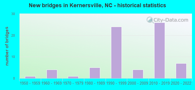
- New bridges - historical statistics
- 11950-1959
- 41960-1969
- 11970-1979
- 51980-1989
- 241990-1999
- 42000-2009
- 262010-2019
- 72020-2022

- Reconstructed bridges - Historical Statistics
- 11950-1959
- 01960-1969
- 01970-1979
- 01980-1989
- 11990-1999


- Bridge Condition - Deck
- 7.7%Excellent
- 23.1%Very good
- 53.8%Good
- 15.4%Satisfactory

- Bridge Condition - Superstructure
- 3.8%Excellent
- 38.5%Very good
- 53.8%Good
- 3.8%Satisfactory

- Bridge Condition - Substructure
- 7.7%Excellent
- 23.1%Very good
- 61.5%Good
- 3.8%Satisfactory
- 3.8%Fair

- Bridge Condition - Channel
- 4.3%Very good
- 60.9%Good
- 21.7%Satisfactory
- 13.0%Fair

- Bridge Condition - Culverts
- 35.7%Good
- 35.7%Satisfactory
- 14.3%Fair
- 14.3%Poor
Find on map >> Show street view
Structure Number: 670046, Location: 0.3 MI. S. JCT. SR2045 (Lat: 36.113028, Lng: -80.064042), Route carried "on" structure: State highway 66, Year Built: 1987, Status: Open, Structure Length: 6.46m (21.19ft), Average Daily Traffic: 26,000 (year 2013), Truck Traffic: 6%, Average Future Daily Traffic: 52,000 (year 2040), Design Load: HS 20+Mod, Features Intersected: US421
Minimum Vertical Clearance: 30+ m (98+ ft), Kilometerpoint: 0.000, Lanes on structure: 6, Lanes under structure: 5, Owner: State Highway Agency, Approaching Roadway Width: 23.1m (75.8ft), Skew: 2 degrees, Material/Design: Steel, Design/Construction: Stringer/Multi-beam, Number Of Spans In Main Unit: 4, Length of Maximum Span: 22.5m (73.8ft), Curb or Sidewalk Widths: Left: 1.2m (3.9ft), Right: 1.2m (3.9ft), Curb-To-Curb Width: 23.1m (75.8ft), Out-to-Out Width: 26.3m (86.3ft)
Condition: Deck: Satisfactory, Superstructure: Good, Substructure: Good, Operating Rating: 89.8 metric tons, Method Used To Determine Operating Rating: Load Factor (LF), Inventory Rating: 65.3 metric tons, Method Used To Determine Inventory Rating: Load Factor (LF), Structural Evaluation: Better than present minimum criteria, Deck Geometry: Meets minimum limits, Underclear: Equal to present minimum criteria, Approach Roadway Alignment: Equal to present desirable criteria, Designated Inspection Frequency: Every 24 months, Inspection Date: June 2020, Deck Structure Type: Concrete Cast-file-Place, Wearing Surface/Protective System: Wearing Surface: Monolithic Concrete, Deck Protection: Epoxy Coated Reinforcing
Find on map >> Show street view
Structure Number: 670066, Location: 0.2 MI. E. JCT. SR4409 (Lat: 36.155886, Lng: -80.100061), Route carried "on" structure: State highway 2024, Year Built: 2000, Status: Open, Structure Length: 0.88m (2.89ft), Average Daily Traffic: 3,500 (year 2015), Truck Traffic: 7%, Average Future Daily Traffic: 7,000 (year 2040), Design Load: HS 20+Mod, Features Intersected: BELEWS CREEK
Minimum Vertical Clearance: 30+ m (98+ ft), Kilometerpoint: 0.000, Lanes on structure: 2, Owner: State Highway Agency, Approaching Roadway Width: 12.1m (39.7ft), Skew: 2 degrees, Material/Design: Concrete continuous, Design/Construction: Culvert, Number Of Spans In Main Unit: 2, Length of Maximum Span: 3.6m (11.8ft)
Condition: Channel: Fair, Culverts: Good, Operating Rating: 57.1 metric tons, Method Used To Determine Operating Rating: Load and Resistance Factor (LRFR), Inventory Rating: 43.5 metric tons, Method Used To Determine Inventory Rating: Load and Resistance Factor (LRFR), Structural Evaluation: Better than present minimum criteria, Waterway Adequacy: Equal to present minimum criteria, Approach Roadway Alignment: Equal to present desirable criteria, Designated Inspection Frequency: Every 24 months, Inspection Date: July 2021
Find on map >> Show street view
Structure Number: 670068, Location: 0.3 MI. E. JCT. SR2021 (Lat: 36.174447, Lng: -80.084464), Route carried "on" structure: State highway 2014, Year Built: 2014, Status: Open, Structure Length: 1.88m (6.17ft), Average Daily Traffic: 2,900 (year 2013), Truck Traffic: 7%, Average Future Daily Traffic: 5,800 (year 2040), Design Load: HL 93, Features Intersected: UT TO BELEWS CREEK
Minimum Vertical Clearance: 30+ m (98+ ft), Kilometerpoint: 0.000, Lanes on structure: 2, Owner: State Highway Agency, Approaching Roadway Width: 9.4m (30.8ft), Material/Design: Prestressed concrete, Design/Construction: Slab, Number Of Spans In Main Unit: 1, Length of Maximum Span: 17.9m (58.7ft), Curb-To-Curb Width: 9.1m (29.9ft), Out-to-Out Width: 10.0m (32.8ft)
Condition: Deck: Very good, Superstructure: Very good, Substructure: Very good, Channel: Good, Operating Rating: 67.1 metric tons, Method Used To Determine Operating Rating: Load and Resistance Factor (LRFR), Inventory Rating: 51.7 metric tons, Method Used To Determine Inventory Rating: Load and Resistance Factor (LRFR), Structural Evaluation: Equal to present desirable criteria, Deck Geometry: Meets minimum limits, Waterway Adequacy: Better than present minimum criteria, Approach Roadway Alignment: Equal to present desirable criteria, Designated Inspection Frequency: Every 24 months, Inspection Date: September 2020, Deck Structure Type: Concrete Precast Panels, Wearing Surface/Protective System: Wearing Surface: Bituminous
Find on map >> Show street view
Structure Number: 67007, Location: 0.4 MI. E. JCT. SR1969 (Lat: 36.187547, Lng: -80.052369), Route carried "on" structure: State highway 2016, Year Built: 2002, Status: Open, Structure Length: 3.41m (11.19ft), Average Daily Traffic: 250 (year 2019), Truck Traffic: 7%, Average Future Daily Traffic: 500 (year 2040), Design Load: HS 20+Mod, Features Intersected: EAST BELEWS CREEK
Minimum Vertical Clearance: 30+ m (98+ ft), Kilometerpoint: 0.000, Lanes on structure: 2, Owner: State Highway Agency, Approaching Roadway Width: 5.7m (18.7ft), Material/Design: Prestressed concrete, Design/Construction: Slab, Number Of Spans In Main Unit: 3, Length of Maximum Span: 11.8m (38.7ft), Curb-To-Curb Width: 7.3m (24.0ft), Out-to-Out Width: 8.3m (27.2ft)
Condition: Deck: Good, Superstructure: Good, Substructure: Good, Channel: Good, Operating Rating: 83.4 metric tons, Method Used To Determine Operating Rating: Load Factor (LF), Inventory Rating: 49.8 metric tons, Method Used To Determine Inventory Rating: Load Factor (LF), Structural Evaluation: Better than present minimum criteria, Deck Geometry: Somewhat better than minimum adequacy, Waterway Adequacy: Better than present minimum criteria, Approach Roadway Alignment: Equal to present desirable criteria, Designated Inspection Frequency: Every 24 months, Inspection Date: September 2021, Deck Structure Type: Concrete Precast Panels, Wearing Surface/Protective System: Wearing Surface: Bituminous
Find on map >> Show street view
Structure Number: 670072, Location: 0.1 MI. E. JCT. SR4241 (Lat: 36.078042, Lng: -80.078956), Route carried "on" structure: State highway 2632, Year Built: 1989, Status: Open, Structure Length: 2.80m (9.19ft), Average Daily Traffic: 4,100 (year 2015), Truck Traffic: 7%, Average Future Daily Traffic: 8,200 (year 2040), Design Load: HS 20+Mod, Features Intersected: ABBOTTS CREEK
Minimum Vertical Clearance: 30+ m (98+ ft), Kilometerpoint: 0.000, Lanes on structure: 2, Owner: State Highway Agency, Approaching Roadway Width: 7.6m (24.9ft), Material/Design: Prestressed concrete, Design/Construction: Slab, Number Of Spans In Main Unit: 3, Length of Maximum Span: 8.8m (28.9ft), Curb-To-Curb Width: 8.2m (26.9ft), Out-to-Out Width: 9.1m (29.9ft)
Condition: Deck: Good, Superstructure: Good, Substructure: Satisfactory, Channel: Fair, Operating Rating: 89.8 metric tons, Method Used To Determine Operating Rating: Load Factor (LF), Inventory Rating: 74.3 metric tons, Method Used To Determine Inventory Rating: Load Factor (LF), Structural Evaluation: Equal to present minimum criteria, Deck Geometry: High priority of corrective action, Waterway Adequacy: Better than present minimum criteria, Approach Roadway Alignment: Equal to present minimum criteria, Designated Inspection Frequency: Every 24 months, Inspection Date: July 2021, Deck Structure Type: Concrete Precast Panels, Wearing Surface/Protective System: Wearing Surface: Bituminous
Find on map >> Show street view
Structure Number: 670073, Location: 0.3 MI. E. JCT. SR2630 (Lat: 36.041325, Lng: -80.089511), Route carried "on" structure: State highway 2624, Year Built: 2017, Status: Open, Structure Length: 3.10m (10.17ft), Average Daily Traffic: 2,100 (year 2015), Truck Traffic: 7%, Average Future Daily Traffic: 4,200 (year 2040), Design Load: HL 93, Features Intersected: ABBOTTS CREEK
Minimum Vertical Clearance: 30+ m (98+ ft), Kilometerpoint: 0.000, Lanes on structure: 2, Owner: State Highway Agency, Approaching Roadway Width: 10.0m (32.8ft), Material/Design: Prestressed concrete, Design/Construction: Box Beam or Girders - Multiple, Number Of Spans In Main Unit: 1, Length of Maximum Span: 30.1m (98.8ft), Curb-To-Curb Width: 9.9m (32.5ft), Out-to-Out Width: 10.9m (35.8ft)
Condition: Deck: Good, Superstructure: Good, Substructure: Good, Channel: Good, Operating Rating: 73.4 metric tons, Method Used To Determine Operating Rating: Load and Resistance Factor (LRFR), Inventory Rating: 46.2 metric tons, Method Used To Determine Inventory Rating: Load and Resistance Factor (LRFR), Structural Evaluation: Better than present minimum criteria, Deck Geometry: Meets minimum limits, Waterway Adequacy: Better than present minimum criteria, Approach Roadway Alignment: Equal to present desirable criteria, Designated Inspection Frequency: Every 24 months, Inspection Date: August 2021, Deck Structure Type: Concrete Precast Panels, Wearing Surface/Protective System: Wearing Surface: Bituminous
Find on map >> Show street view
Structure Number: 670075, Location: 0.2 MI. S. JCT. SR2683 (Lat: 36.055178, Lng: -80.093350), Route carried "on" structure: State highway 2630, Year Built: 2001, Status: Open, Structure Length: 2.43m (7.97ft), Average Daily Traffic: 2,700 (year 2015), Truck Traffic: 7%, Average Future Daily Traffic: 5,400 (year 2040), Design Load: HS 20+Mod, Features Intersected: UT TO ABBOTTS CREEK
Minimum Vertical Clearance: 30+ m (98+ ft), Kilometerpoint: 0.000, Lanes on structure: 2, Owner: State Highway Agency, Approaching Roadway Width: 6.0m (19.7ft), Skew: 3 degrees, Material/Design: Prestressed concrete, Design/Construction: Slab, Number Of Spans In Main Unit: 2, Length of Maximum Span: 16.1m (52.8ft), Curb-To-Curb Width: 12.8m (42.0ft), Out-to-Out Width: 13.7m (44.9ft)
Condition: Deck: Good, Superstructure: Good, Substructure: Good, Channel: Good, Operating Rating: 65.3 metric tons, Method Used To Determine Operating Rating: Load Factor (LF), Inventory Rating: 39.0 metric tons, Method Used To Determine Inventory Rating: Load Factor (LF), Structural Evaluation: Better than present minimum criteria, Deck Geometry: Equal to present minimum criteria, Waterway Adequacy: Better than present minimum criteria, Approach Roadway Alignment: Equal to present desirable criteria, Designated Inspection Frequency: Every 24 months, Inspection Date: September 2021, Deck Structure Type: Concrete Precast Panels, Wearing Surface/Protective System: Wearing Surface: Bituminous
Find on map >> Show street view
Structure Number: 670153, Location: 0.3 MI. E. JCT. SR2630 (Lat: 36.064742, Lng: -80.085478), Route carried "on" structure: State highway 2631, Year Built: 2015, Status: Open, Structure Length: 2.04m (6.69ft), Average Daily Traffic: 500 (year 2019), Truck Traffic: 7%, Average Future Daily Traffic: 1,000 (year 2040), Design Load: HL 93, Features Intersected: ABBOTTS CREEK
Minimum Vertical Clearance: 30+ m (98+ ft), Kilometerpoint: 0.000, Lanes on structure: 2, Owner: State Highway Agency, Approaching Roadway Width: 8.2m (26.9ft), Material/Design: Prestressed concrete, Design/Construction: Slab, Number Of Spans In Main Unit: 1, Length of Maximum Span: 19.5m (64.0ft), Curb-To-Curb Width: 8.2m (26.9ft), Out-to-Out Width: 9.1m (29.9ft)
Condition: Deck: Very good, Superstructure: Very good, Substructure: Good, Channel: Good, Operating Rating: 56.2 metric tons, Method Used To Determine Operating Rating: Load and Resistance Factor (LRFR), Inventory Rating: 41.7 metric tons, Method Used To Determine Inventory Rating: Load and Resistance Factor (LRFR), Structural Evaluation: Better than present minimum criteria, Deck Geometry: Somewhat better than minimum adequacy, Waterway Adequacy: Better than present minimum criteria, Approach Roadway Alignment: Equal to present desirable criteria, Designated Inspection Frequency: Every 24 months, Inspection Date: April 2021, Deck Structure Type: Concrete Precast Panels, Wearing Surface/Protective System: Wearing Surface: Bituminous
Find on map >> Show street view
Structure Number: 670167, Location: 0.8 MI. S. JCT. SR2643 (Lat: 36.110244, Lng: -80.091328), Route carried "on" structure: State highway 4315, Year Built: 1992, Status: Open, Structure Length: 8.26m (27.10ft), Average Daily Traffic: 29,000 (year 2013), Truck Traffic: 6%, Average Future Daily Traffic: 58,000 (year 2040), Design Load: HS 20+Mod, Features Intersected: US421
Minimum Vertical Clearance: 30+ m (98+ ft), Kilometerpoint: 0.000, Lanes on structure: 2, Lanes under structure: 4, Owner: State Highway Agency, Approaching Roadway Width: 19.5m (64.0ft), Skew: 4 degrees, Material/Design: Steel, Design/Construction: Stringer/Multi-beam, Number Of Spans In Main Unit: 4, Length of Maximum Span: 29.2m (95.8ft), Curb or Sidewalk Widths: Left: 0.0m, Right: 1.2m (3.9ft), Curb-To-Curb Width: 23.1m (75.8ft), Out-to-Out Width: 25.1m (82.3ft)
Condition: Deck: Satisfactory, Superstructure: Good, Substructure: Good, Operating Rating: 89.8 metric tons, Method Used To Determine Operating Rating: Load Factor (LF), Inventory Rating: 55.3 metric tons, Method Used To Determine Inventory Rating: Load Factor (LF), Structural Evaluation: Better than present minimum criteria, Deck Geometry: Superior to present desirable criteria, Underclear: Equal to present minimum criteria, Approach Roadway Alignment: Equal to present desirable criteria, Designated Inspection Frequency: Every 24 months, Inspection Date: June 2020, Deck Structure Type: Concrete Cast-file-Place, Wearing Surface/Protective System: Wearing Surface: Monolithic Concrete, Deck Protection: Epoxy Coated Reinforcing
Find on map >> Show street view
Structure Number: 670194, Location: 0.6 MI. W. JCT. NC66 (Lat: 36.095883, Lng: -80.070200), Route carried "on" structure: State highway 2640, Year Built: 1974, Status: Open, Structure Length: 0.82m (2.69ft), Average Daily Traffic: 7,800 (year 2019), Truck Traffic: 7%, Average Future Daily Traffic: 15,600 (year 2040), Design Load: HS 20+Mod, Features Intersected: ABBOTTS CREEK
Minimum Vertical Clearance: 30+ m (98+ ft), Kilometerpoint: 0.000, Lanes on structure: 2, Owner: State Highway Agency, Approaching Roadway Width: 7.0m (23.0ft), Skew: 1 degrees, Material/Design: Steel, Design/Construction: Culvert, Number Of Spans In Main Unit: 3, Length of Maximum Span: 2.1m (6.9ft)
Condition: Channel: Good, Culverts: Fair, Operating Rating: 89.8 metric tons, Method Used To Determine Operating Rating: Load and Resistance Factor (LRFR), Inventory Rating: 89.8 metric tons, Method Used To Determine Inventory Rating: Load and Resistance Factor (LRFR), Structural Evaluation: Somewhat better than minimum adequacy, Waterway Adequacy: Better than present minimum criteria, Approach Roadway Alignment: Equal to present desirable criteria, Designated Inspection Frequency: Every 24 months, Inspection Date: September 2021
Find on map >> Show street view
Structure Number: 670202, Location: 1.4 MI.W.JCT.SR2649 (Lat: 36.115525, Lng: -80.123000), Route carried "on" structure: City street , Year Built: 1962, Year Reconstructed: 1997, Status: Posted for load, Structure Length: 1.09m (3.58ft), Average Daily Traffic: 670 (year 2001), Truck Traffic: 7%, Average Future Daily Traffic: 1,340 (year 2040), Features Intersected: KERNER MILL CREEK, Facility Carried by Structure: BLUFF SCHOOL ROAD
Minimum Vertical Clearance: 30+ m (98+ ft), Kilometerpoint: 0.000, Lanes on structure: 1, Owner: City or Municipal Highway Agency, Approaching Roadway Width: 3.3m (10.8ft), Material/Design: Steel, Design/Construction: Stringer/Multi-beam, Number Of Spans In Main Unit: 1, Length of Maximum Span: 10.3m (33.8ft), Curb or Sidewalk Widths: Left: 0.1m (0.3ft), Right: 0.1m (0.3ft), Curb-To-Curb Width: 4.5m (14.8ft), Out-to-Out Width: 4.8m (15.7ft)
Condition: Deck: Good, Superstructure: Good, Substructure: Good, Channel: Satisfactory, Operating Rating: 19.0 metric tons, Method Used To Determine Operating Rating: Load and Resistance Factor (LRFR), Inventory Rating: 10.8 metric tons, Method Used To Determine Inventory Rating: Load and Resistance Factor (LRFR), Structural Evaluation: High priority of corrective action, Deck Geometry: High priority of replacement, Waterway Adequacy: Somewhat better than minimum adequacy, Approach Roadway Alignment: Equal to present minimum criteria, Bridge Posting: Required (Relationship of Operating Rating to Maximum Legal Load: > 39.9% below), Designated Inspection Frequency: Every 24 months, Inspection Date: May 2020, Deck Structure Type: Wood or Timber, Wearing Surface/Protective System: Wearing Surface: Bituminous
Find on map >> Show street view
Structure Number: 670219, Location: 0.1 MI. W. JCT. SR2630 (Lat: 36.057828, Lng: -80.094156), Route carried "on" structure: State highway 2683, Year Built: 1964, Status: Open, Structure Length: 0.79m (2.59ft), Average Daily Traffic: 600 (year 2019), Truck Traffic: 7%, Average Future Daily Traffic: 1,200 (year 2040), Features Intersected: UT TO ABBOTTS CREEK
Minimum Vertical Clearance: 30+ m (98+ ft), Kilometerpoint: 0.000, Lanes on structure: 2, Owner: State Highway Agency, Approaching Roadway Width: 5.4m (17.7ft), Skew: 1 degrees, Material/Design: Steel, Design/Construction: Stringer/Multi-beam, Number Of Spans In Main Unit: 1, Length of Maximum Span: 7.6m (24.9ft), Curb or Sidewalk Widths: Left: 0.1m (0.3ft), Right: 0.1m (0.3ft), Curb-To-Curb Width: 7.3m (24.0ft), Out-to-Out Width: 7.5m (24.6ft)
Condition: Deck: Good, Superstructure: Satisfactory, Substructure: Fair, Channel: Good, Operating Rating: 49.8 metric tons, Method Used To Determine Operating Rating: Load Factor (LF), Inventory Rating: 29.9 metric tons, Method Used To Determine Inventory Rating: Load Factor (LF), Structural Evaluation: Somewhat better than minimum adequacy, Deck Geometry: Meets minimum limits, Waterway Adequacy: Somewhat better than minimum adequacy, Approach Roadway Alignment: Equal to present desirable criteria, Designated Inspection Frequency: Every 24 months, Inspection Date: September 2021, Deck Structure Type: Wood or Timber, Wearing Surface/Protective System: Wearing Surface: Bituminous
Find on map >> Show street view
Structure Number: 670228, Location: 0.2 MI.N.JCT.GERRY DR. (Lat: 36.118225, Lng: -80.137825), Route carried "on" structure: City street , Year Built: 1960, Status: Open, Structure Length: 1.67m (5.48ft), Average Daily Traffic: 375 (year 1999), Truck Traffic: 7%, Average Future Daily Traffic: 750 (year 2040), Design Load: HS 20+Mod, Features Intersected: KERNER`S MILL CREEK, Facility Carried by Structure: DOE RUN DR.
Minimum Vertical Clearance: 30+ m (98+ ft), Kilometerpoint: 0.000, Lanes on structure: 2, Owner: City or Municipal Highway Agency, Approaching Roadway Width: 6.0m (19.7ft), Skew: 3 degrees, Material/Design: Concrete continuous, Design/Construction: Culvert, Number Of Spans In Main Unit: 5, Length of Maximum Span: 2.7m (8.9ft)
Condition: Channel: Satisfactory, Culverts: Good, Operating Rating: 41.7 metric tons, Method Used To Determine Operating Rating: Field evaluation and documented engineering judgment, Inventory Rating: 32.6 metric tons, Method Used To Determine Inventory Rating: Field evaluation and documented engineering judgment, Structural Evaluation: Better than present minimum criteria, Waterway Adequacy: Somewhat better than minimum adequacy, Approach Roadway Alignment: Equal to present desirable criteria, Designated Inspection Frequency: Every 24 months, Inspection Date: May 2020
Find on map >> Show street view
Structure Number: 670367, Location: 1.6 MI. E. JCT. SR2657 (Lat: 36.111936, Lng: -80.114656), Route carried "on" structure: Business Interstate 40, Year Built: 1953, Year Reconstructed: 1961, Status: Open, Structure Length: 1.09m (3.58ft), Average Daily Traffic: 48,000 (year 2013), Truck Traffic: 12%, Average Future Daily Traffic: 96,000 (year 2040), Design Load: HS 20+Mod, Features Intersected: SMITH CREEK
Minimum Vertical Clearance: 30+ m (98+ ft), Kilometerpoint: 3.871, Lanes on structure: 4, Base Highway Network: Yes (Inventory Route: 1, Subroute: 40), Owner: State Highway Agency, Approaching Roadway Width: 21.9m (71.9ft), Skew: 24 degrees, Material/Design: Concrete continuous, Design/Construction: Culvert, Number Of Spans In Main Unit: 3, Length of Maximum Span: 2.4m (7.9ft)
Condition: Channel: Good, Culverts: Fair, Operating Rating: 64.4 metric tons, Method Used To Determine Operating Rating: Load and Resistance Factor (LRFR), Inventory Rating: 49.8 metric tons, Method Used To Determine Inventory Rating: Load and Resistance Factor (LRFR), Structural Evaluation: Somewhat better than minimum adequacy, Waterway Adequacy: Better than present minimum criteria, Approach Roadway Alignment: Equal to present desirable criteria, Designated Inspection Frequency: Every 24 months, Inspection Date: May 2020
Find on map >> Show street view
Structure Number: 670368, Location: 0.8 MI. N. JCT. NC66 (Lat: 36.110378, Lng: -80.077983), Route carried "on" structure: State highway 2643, Year Built: 2012, Status: Open, Structure Length: 6.18m (20.28ft), Average Daily Traffic: 9,400 (year 2013), Truck Traffic: 7%, Average Future Daily Traffic: 18,800 (year 2040), Design Load: HL 93, Features Intersected: I40 BUS
Minimum Vertical Clearance: 30+ m (98+ ft), Kilometerpoint: 0.000, Lanes on structure: 2, Lanes under structure: 4, Owner: State Highway Agency, Approaching Roadway Width: 7.3m (24.0ft), Skew: 2 degrees, Material/Design: Prestressed concrete continuous, Design/Construction: Stringer/Multi-beam, Number Of Spans In Main Unit: 2, Length of Maximum Span: 29.8m (97.8ft), Curb or Sidewalk Widths: Left: 1.6m (5.2ft), Right: 1.6m (5.2ft), Curb-To-Curb Width: 11.1m (36.4ft), Out-to-Out Width: 15.1m (49.5ft)
Condition: Deck: Good, Superstructure: Good, Substructure: Good, Operating Rating: 75.2 metric tons, Method Used To Determine Operating Rating: Load and Resistance Factor (LRFR), Inventory Rating: 51.7 metric tons, Method Used To Determine Inventory Rating: Load and Resistance Factor (LRFR), Structural Evaluation: Better than present minimum criteria, Deck Geometry: Meets minimum limits, Underclear: Equal to present minimum criteria, Approach Roadway Alignment: Equal to present desirable criteria, Designated Inspection Frequency: Every 24 months, Inspection Date: August 2020, Deck Structure Type: Concrete Cast-file-Place, Wearing Surface/Protective System: Wearing Surface: Monolithic Concrete, Deck Protection: Epoxy Coated Reinforcing
Find on map >> Show street view
Structure Number: 67037, Location: 0.1 MI. S. JCT. SR2042 (Lat: 36.106542, Lng: -80.046450), Route carried "on" structure: State highway 2601, Year Built: 2014, Status: Open, Structure Length: 4.75m (15.58ft), Average Daily Traffic: 5,000 (year 2013), Truck Traffic: 7%, Average Future Daily Traffic: 10,000 (year 2040), Design Load: HL 93, Features Intersected: I40 BUS, US421
Minimum Vertical Clearance: 30+ m (98+ ft), Kilometerpoint: 0.000, Lanes on structure: 6, Lanes under structure: 4, Owner: State Highway Agency, Approaching Roadway Width: 29.5m (96.8ft), Skew: 21 degrees, Material/Design: Steel, Design/Construction: Stringer/Multi-beam, Number Of Spans In Main Unit: 1, Length of Maximum Span: 46.3m (151.9ft), Curb-To-Curb Width: 33.4m (109.6ft), Out-to-Out Width: 33.4m (109.6ft)
Condition: Deck: Good, Superstructure: Good, Substructure: Good, Operating Rating: 75.2 metric tons, Method Used To Determine Operating Rating: Load and Resistance Factor (LRFR), Inventory Rating: 58.0 metric tons, Method Used To Determine Inventory Rating: Load and Resistance Factor (LRFR), Structural Evaluation: Better than present minimum criteria, Deck Geometry: Superior to present desirable criteria, Underclear: Superior to present desirable criteria, Approach Roadway Alignment: Equal to present desirable criteria, Designated Inspection Frequency: Every 24 months, Inspection Date: August 2020, Deck Structure Type: Concrete Cast-file-Place, Wearing Surface/Protective System: Wearing Surface: Monolithic Concrete, Deck Protection: Epoxy Coated Reinforcing
Find on map >> Show street view
Structure Number: 670439, Location: 0.3 MI.S.JCT.SR2640 (Lat: 36.085439, Lng: -80.063694), Route carried "on" structure: State highway 66, Year Built: 1990, Status: Open, Structure Length: 6.79m (22.28ft), Average Daily Traffic: 15,000 (year 2015), Truck Traffic: 6%, Average Future Daily Traffic: 30,000 (year 2040), Design Load: HS 20+Mod, Features Intersected: I40
Minimum Vertical Clearance: 30+ m (98+ ft), Kilometerpoint: 0.000, Lanes on structure: 5, Lanes under structure: 13, Owner: State Highway Agency, Approaching Roadway Width: 20.7m (67.9ft), Skew: 2 degrees, Material/Design: Prestressed concrete, Design/Construction: Stringer/Multi-beam, Number Of Spans In Main Unit: 4, Length of Maximum Span: 21.0m (68.9ft), Curb-To-Curb Width: 20.7m (67.9ft), Out-to-Out Width: 21.6m (70.9ft)
Condition: Deck: Satisfactory, Superstructure: Good, Substructure: Good, Operating Rating: 89.8 metric tons, Method Used To Determine Operating Rating: Load Factor (LF), Inventory Rating: 41.7 metric tons, Method Used To Determine Inventory Rating: Load Factor (LF), Structural Evaluation: Better than present minimum criteria, Deck Geometry: Somewhat better than minimum adequacy, Underclear: Somewhat better than minimum adequacy, Approach Roadway Alignment: Equal to present desirable criteria, Designated Inspection Frequency: Every 24 months, Inspection Date: July 2020, Deck Structure Type: Concrete Cast-file-Place, Wearing Surface/Protective System: Wearing Surface: Integral Concrete, Deck Protection: Epoxy Coated Reinforcing
Find on map >> Show street view
Structure Number: 670442, Location: 0.5 MI. S. JCT. NC66 (Lat: 36.087361, Lng: -80.053403), Route carried "on" structure: State highway 2604, Year Built: 1990, Status: Open, Structure Length: 6.33m (20.77ft), Average Daily Traffic: 400 (year 2015), Truck Traffic: 7%, Average Future Daily Traffic: 800 (year 2040), Design Load: HS 20+Mod, Features Intersected: I40
Minimum Vertical Clearance: 30+ m (98+ ft), Kilometerpoint: 0.000, Lanes on structure: 2, Lanes under structure: 4, Owner: State Highway Agency, Approaching Roadway Width: 9.4m (30.8ft), Material/Design: Prestressed concrete, Design/Construction: Stringer/Multi-beam, Number Of Spans In Main Unit: 4, Length of Maximum Span: 18.8m (61.7ft), Curb-To-Curb Width: 9.4m (30.8ft), Out-to-Out Width: 10.3m (33.8ft)
Condition: Deck: Good, Superstructure: Good, Substructure: Good, Operating Rating: 71.6 metric tons, Method Used To Determine Operating Rating: Load Factor (LF), Inventory Rating: 37.1 metric tons, Method Used To Determine Inventory Rating: Load Factor (LF), Structural Evaluation: Better than present minimum criteria, Deck Geometry: Equal to present minimum criteria, Underclear: Equal to present minimum criteria, Approach Roadway Alignment: Equal to present desirable criteria, Designated Inspection Frequency: Every 24 months, Inspection Date: July 2020, Deck Structure Type: Concrete Cast-file-Place, Wearing Surface/Protective System: Wearing Surface: Bituminous
Find on map >> Show street view
Structure Number: 670447, Location: 0.1 MI. E. JCT. SR2637 (Lat: 36.082811, Lng: -80.089828), Route carried "on" structure: State highway 2632, Year Built: 1991, Status: Open, Structure Length: 7.37m (24.18ft), Average Daily Traffic: 4,600 (year 2015), Truck Traffic: 7%, Average Future Daily Traffic: 9,200 (year 2040), Design Load: HS 20+Mod, Features Intersected: I40
Minimum Vertical Clearance: 30+ m (98+ ft), Kilometerpoint: 0.000, Lanes on structure: 2, Lanes under structure: 4, Owner: State Highway Agency, Approaching Roadway Width: 7.6m (24.9ft), Skew: 3 degrees, Material/Design: Prestressed concrete, Design/Construction: Stringer/Multi-beam, Number Of Spans In Main Unit: 4, Length of Maximum Span: 22.5m (73.8ft), Curb-To-Curb Width: 9.7m (31.8ft), Out-to-Out Width: 10.6m (34.8ft)
Condition: Deck: Good, Superstructure: Very good, Substructure: Good, Operating Rating: 84.3 metric tons, Method Used To Determine Operating Rating: Load Factor (LF), Inventory Rating: 45.3 metric tons, Method Used To Determine Inventory Rating: Load Factor (LF), Structural Evaluation: Better than present minimum criteria, Deck Geometry: Meets minimum limits, Underclear: Equal to present minimum criteria, Approach Roadway Alignment: Equal to present desirable criteria, Designated Inspection Frequency: Every 24 months, Inspection Date: July 2021, Deck Structure Type: Concrete Cast-file-Place, Wearing Surface/Protective System: Wearing Surface: Integral Concrete, Deck Protection: Epoxy Coated Reinforcing
Find on map >> Show street view
Structure Number: 670457, Location: 0.84 MI. E. JCT. NC66 (Lat: 36.088183, Lng: -80.049014), Route carried "on" structure: Bypass Interstate 40, Year Built: 1992, Status: Open, Structure Length: 0.70m (2.30ft), Average Daily Traffic: 60,000 (year 2013), Truck Traffic: 16%, Average Future Daily Traffic: 120,000 (year 2040), Design Load: HS 20+Mod, Features Intersected: WEST FORK DEEP RIVER
Minimum Vertical Clearance: 30+ m (98+ ft), Kilometerpoint: 62.271, Lanes on structure: 4, Base Highway Network: Yes (Inventory Route: 1, Subroute: 40), Owner: State Highway Agency, Approaching Roadway Width: 24.3m (79.7ft), Skew: 21 degrees, Material/Design: Concrete continuous, Design/Construction: Culvert, Number Of Spans In Main Unit: 2, Length of Maximum Span: 3.3m (10.8ft)
Condition: Channel: Good, Culverts: Satisfactory, Operating Rating: 41.7 metric tons, Method Used To Determine Operating Rating: Field evaluation and documented engineering judgment, Inventory Rating: 32.6 metric tons, Method Used To Determine Inventory Rating: Field evaluation and documented engineering judgment, Structural Evaluation: Equal to present minimum criteria, Waterway Adequacy: Better than present minimum criteria, Approach Roadway Alignment: Equal to present desirable criteria, Designated Inspection Frequency: Every 24 months, Inspection Date: July 2020
Find on map >> Show street view
Structure Number: 670458, Location: 1.3 MI. N. JCT. SR2632 (Lat: 36.075008, Lng: -80.109550), Route carried "on" structure: State highway 2643, Year Built: 1992, Status: Open, Structure Length: 6.49m (21.29ft), Average Daily Traffic: 15,000 (year 2013), Truck Traffic: 7%, Average Future Daily Traffic: 30,000 (year 2040), Design Load: HS 20+Mod, Features Intersected: I40
Minimum Vertical Clearance: 30+ m (98+ ft), Kilometerpoint: 0.000, Lanes on structure: 2, Lanes under structure: 4, Owner: State Highway Agency, Approaching Roadway Width: 14.3m (46.9ft), Skew: 2 degrees, Material/Design: Prestressed concrete, Design/Construction: Stringer/Multi-beam, Number Of Spans In Main Unit: 4, Length of Maximum Span: 19.8m (65.0ft), Curb-To-Curb Width: 14.5m (47.6ft), Out-to-Out Width: 15.5m (50.9ft)
Condition: Deck: Satisfactory, Superstructure: Good, Substructure: Good, Operating Rating: 80.7 metric tons, Method Used To Determine Operating Rating: Load Factor (LF), Inventory Rating: 38.1 metric tons, Method Used To Determine Inventory Rating: Load Factor (LF), Structural Evaluation: Better than present minimum criteria, Deck Geometry: Superior to present desirable criteria, Underclear: Equal to present minimum criteria, Approach Roadway Alignment: Equal to present desirable criteria, Designated Inspection Frequency: Every 24 months, Inspection Date: July 2020, Deck Structure Type: Concrete Cast-file-Place, Wearing Surface/Protective System: Wearing Surface: Integral Concrete, Deck Protection: Epoxy Coated Reinforcing
Find on map >> Show street view
Structure Number: 670459, Location: 0.7 MI. W. JCT. NC66 (Lat: 36.083406, Lng: -80.075306), Route carried "on" structure: Bypass Interstate 40, Year Built: 1992, Status: Open, Structure Length: 1.61m (5.28ft), Average Daily Traffic: 62,000 (year 2013), Truck Traffic: 16%, Average Future Daily Traffic: 124,000 (year 2040), Design Load: HS 20+Mod, Features Intersected: ABBOTTS CREEK
Minimum Vertical Clearance: 30+ m (98+ ft), Kilometerpoint: 61.814, Lanes on structure: 4, Base Highway Network: Yes (Inventory Route: 1, Subroute: 40), Owner: State Highway Agency, Approaching Roadway Width: 24.3m (79.7ft), Skew: 24 degrees, Material/Design: Concrete continuous, Design/Construction: Culvert, Number Of Spans In Main Unit: 3, Length of Maximum Span: 3.6m (11.8ft)
Condition: Channel: Good, Culverts: Satisfactory, Operating Rating: 89.8 metric tons, Method Used To Determine Operating Rating: Load and Resistance Factor (LRFR), Inventory Rating: 78.0 metric tons, Method Used To Determine Inventory Rating: Load and Resistance Factor (LRFR), Structural Evaluation: Equal to present minimum criteria, Waterway Adequacy: Better than present minimum criteria, Approach Roadway Alignment: Equal to present desirable criteria, Designated Inspection Frequency: Every 24 months, Inspection Date: July 2020
Find on map >> Show street view
Structure Number: 670528, Location: 0.2 MI. E. JCT. NC66 (Lat: 36.104383, Lng: -80.055681), Route carried "on" structure: State highway 4319, Year Built: 1992, Status: Open, Structure Length: 1.09m (3.58ft), Average Daily Traffic: 4,000 (year 2019), Truck Traffic: 7%, Average Future Daily Traffic: 8,000 (year 2040), Design Load: HS 20+Mod, Features Intersected: WEST FORK DEEP RIVER
Minimum Vertical Clearance: 30+ m (98+ ft), Kilometerpoint: 0.000, Lanes on structure: 3, Owner: State Highway Agency, Approaching Roadway Width: 12.1m (39.7ft), Skew: 2 degrees, Material/Design: Steel, Design/Construction: Culvert, Number Of Spans In Main Unit: 3, Length of Maximum Span: 2.7m (8.9ft)
Condition: Channel: Fair, Culverts: Poor, Operating Rating: 89.8 metric tons, Method Used To Determine Operating Rating: Load and Resistance Factor (LRFR), Inventory Rating: 89.8 metric tons, Method Used To Determine Inventory Rating: Load and Resistance Factor (LRFR), Structural Evaluation: Meets minimum limits, Waterway Adequacy: Better than present minimum criteria, Approach Roadway Alignment: Equal to present desirable criteria, Designated Inspection Frequency: Every 24 months, Inspection Date: December 2021
Find on map >> Show street view
Structure Number: 670594, Location: 0.09 MI. E. JCT. SR4503 (Lat: 36.165319, Lng: -80.101000), Route carried "on" structure: State highway 4427, Year Built: 1995, Status: Open, Structure Length: 1.24m (4.07ft), Average Daily Traffic: 50 (year 2000), Average Future Daily Traffic: 100 (year 2040), Design Load: HS 20+Mod, Features Intersected: BELEWS CREEK
Minimum Vertical Clearance: 30+ m (98+ ft), Kilometerpoint: 0.000, Lanes on structure: 2, Owner: State Highway Agency, Approaching Roadway Width: 6.4m (21.0ft), Material/Design: Concrete, Design/Construction: Culvert, Number Of Spans In Main Unit: 4, Length of Maximum Span: 2.7m (8.9ft)
Condition: Channel: Satisfactory, Culverts: Satisfactory, Operating Rating: 41.7 metric tons, Method Used To Determine Operating Rating: Field evaluation and documented engineering judgment, Inventory Rating: 32.6 metric tons, Method Used To Determine Inventory Rating: Field evaluation and documented engineering judgment, Structural Evaluation: Equal to present minimum criteria, Waterway Adequacy: Equal to present minimum criteria, Approach Roadway Alignment: Equal to present desirable criteria, Designated Inspection Frequency: Every 24 months, Inspection Date: August 2021
Find on map >> Show street view
Structure Number: 670602, Location: 0.3MI.N.JCT.REGENTS PARK (Lat: 36.125222, Lng: -80.120733), Route carried "on" structure: City street , Year Built: 1960, Status: Open, Structure Length: 1.03m (3.38ft), Average Daily Traffic: 750 (year 1999), Truck Traffic: 7%, Average Future Daily Traffic: 1,500 (year 2040), Features Intersected: KERNERS MILLCREEK, Facility Carried by Structure: CHESHAM DR.
Minimum Vertical Clearance: 30+ m (98+ ft), Kilometerpoint: 0.000, Lanes on structure: 2, Owner: City or Municipal Highway Agency, Approaching Roadway Width: 6.4m (21.0ft), Skew: 1 degrees, Material/Design: Steel, Design/Construction: Culvert, Number Of Spans In Main Unit: 3, Length of Maximum Span: 2.7m (8.9ft)
Condition: Channel: Satisfactory, Culverts: Poor, Operating Rating: 89.8 metric tons, Method Used To Determine Operating Rating: Load and Resistance Factor (LRFR), Inventory Rating: 89.8 metric tons, Method Used To Determine Inventory Rating: Load and Resistance Factor (LRFR), Structural Evaluation: Meets minimum limits, Waterway Adequacy: Better than present minimum criteria, Approach Roadway Alignment: Equal to present desirable criteria, Designated Inspection Frequency: Every 24 months, Inspection Date: May 2020
Find on map >> Show street view
Structure Number: 67066, Location: 0.6 MI.S.JCT.N.MAIN ST. (Lat: 36.120253, Lng: -80.060550), Route carried "on" structure: City street , Year Built: 2004, Status: Open, Structure Length: 0.85m (2.79ft), Average Daily Traffic: 1,600 (year 2004), Truck Traffic: 6%, Average Future Daily Traffic: 3,200 (year 2040), Design Load: HS 20, Features Intersected: REEDY FORK CREEK, Facility Carried by Structure: GRALIN STREET
Minimum Vertical Clearance: 30+ m (98+ ft), Kilometerpoint: 0.000, Lanes on structure: 3, Owner: City or Municipal Highway Agency, Approaching Roadway Width: 11.2m (36.7ft), Material/Design: Steel, Design/Construction: Culvert, Number Of Spans In Main Unit: 3, Length of Maximum Span: 2.4m (7.9ft)
Condition: Channel: Good, Culverts: Good, Operating Rating: 41.7 metric tons, Method Used To Determine Operating Rating: Field evaluation and documented engineering judgment, Inventory Rating: 32.6 metric tons, Method Used To Determine Inventory Rating: Field evaluation and documented engineering judgment, Structural Evaluation: Better than present minimum criteria, Waterway Adequacy: Better than present minimum criteria, Approach Roadway Alignment: Equal to present desirable criteria, Designated Inspection Frequency: Every 24 months, Inspection Date: May 2020
Find on map >> Show street view
Structure Number: 670665, Location: .4 MI N. SR 2679 (Lat: 36.075000, Lng: -80.109722), Route carried "on" structure: State highway 2643, Year Built: 2014, Status: Open, Structure Length: 5.09m (16.70ft), Average Daily Traffic: 24,000 (year 2019), Truck Traffic: 7%, Average Future Daily Traffic: 48,000 (year 2040), Design Load: HL 93, Features Intersected: I 40
Minimum Vertical Clearance: 30+ m (98+ ft), Kilometerpoint: 0.000, Lanes on structure: 3, Lanes under structure: 4, Owner: State Highway Agency, Approaching Roadway Width: 13.7m (44.9ft), Skew: 2 degrees, Material/Design: Prestressed concrete, Design/Construction: Stringer/Multi-beam, Length of Maximum Span: 24.3m (79.7ft), Curb or Sidewalk Widths: Left: 0.0m, Right: 1.6m (5.2ft), Curb-To-Curb Width: 12.7m (41.7ft), Out-to-Out Width: 15.3m (50.2ft)
Condition: Deck: Good, Superstructure: Very good, Substructure: Good, Operating Rating: 58.9 metric tons, Method Used To Determine Operating Rating: Load and Resistance Factor (LRFR), Inventory Rating: 45.3 metric tons, Method Used To Determine Inventory Rating: Load and Resistance Factor (LRFR), Structural Evaluation: Better than present minimum criteria, Deck Geometry: Meets minimum limits, Underclear: Better than present minimum criteria, Approach Roadway Alignment: Equal to present desirable criteria, Designated Inspection Frequency: Every 24 months, Inspection Date: April 2021, Deck Structure Type: Concrete Cast-file-Place, Wearing Surface/Protective System: Wearing Surface: Integral Concrete, Deck Protection: Epoxy Coated Reinforcing
Find on map >> Show street view
Structure Number: 670673, Location: 0.2 MI.N. JCT.US421N.RAMP (Lat: 36.116508, Lng: -80.129231), Route carried "on" structure: Interstate 7, Year Built: 2020, Status: Open, Structure Length: 9.44m (30.97ft), Average Daily Traffic: 16,500 (year 2018), Truck Traffic: 16%, Average Future Daily Traffic: 33,000 (year 2040), Design Load: H 10, Features Intersected: SMITH CREEK
Minimum Vertical Clearance: 30+ m (98+ ft), Kilometerpoint: 0.000, Lanes on structure: 2, Base Highway Network: Yes (Inventory Route: 1, Subroute: 74), Owner: State Highway Agency, Approaching Roadway Width: 9.1m (29.9ft), Skew: 12 degrees, Material/Design: Prestressed concrete, Design/Construction: Stringer/Multi-beam, Number Of Spans In Main Unit: 3, Length of Maximum Span: 35.6m (116.8ft), Curb-To-Curb Width: 9.1m (29.9ft), Out-to-Out Width: 10.1m (33.1ft)
Condition: Deck: Very good, Superstructure: Very good, Substructure: Very good, Channel: Very good, Operating Rating: 69.8 metric tons, Method Used To Determine Operating Rating: Load and Resistance Factor (LRFR), Inventory Rating: 49.8 metric tons, Method Used To Determine Inventory Rating: Load and Resistance Factor (LRFR), Structural Evaluation: Equal to present desirable criteria, Deck Geometry: Meets minimum limits, Waterway Adequacy: Equal to present desirable criteria, Approach Roadway Alignment: Equal to present desirable criteria, Designated Inspection Frequency: Every 24 months, Inspection Date: April 2020, Deck Structure Type: Concrete Cast-file-Place, Wearing Surface/Protective System: Wearing Surface: Monolithic Concrete
Find on map >> Show street view
Structure Number: 670678, Location: 0.7 MI. N.JCT.US 421 RAMP (Lat: 36.112869, Lng: -80.130089), Route carried "on" structure: Interstate 74, Year Built: 2020, Status: Open, Structure Length: 6.58m (21.59ft), Average Daily Traffic: 26,250 (year 2018), Truck Traffic: 16%, Average Future Daily Traffic: 52,500 (year 2040), Design Load: H 10, Features Intersected: I-40/BUS/US 421
Minimum Vertical Clearance: 30+ m (98+ ft), Kilometerpoint: 16.246, Lanes on structure: 2, Lanes under structure: 4, Base Highway Network: Yes (Inventory Route: 1, Subroute: 74), Owner: State Highway Agency, Approaching Roadway Width: 18.5m (60.7ft), Material/Design: Prestressed concrete, Design/Construction: Stringer/Multi-beam, Number Of Spans In Main Unit: 2, Length of Maximum Span: 33.2m (108.9ft), Curb-To-Curb Width: 18.4m (60.4ft), Out-to-Out Width: 19.4m (63.6ft)
Condition: Deck: Very good, Superstructure: Very good, Substructure: Very good, Operating Rating: 75.2 metric tons, Method Used To Determine Operating Rating: Load and Resistance Factor (LRFR), Inventory Rating: 57.1 metric tons, Method Used To Determine Inventory Rating: Load and Resistance Factor (LRFR), Structural Evaluation: Equal to present desirable criteria, Deck Geometry: Superior to present desirable criteria, Underclear: Equal to present minimum criteria, Approach Roadway Alignment: Equal to present desirable criteria, Designated Inspection Frequency: Every 24 months, Inspection Date: April 2020, Deck Structure Type: Concrete Cast-file-Place, Wearing Surface/Protective System: Wearing Surface: Monolithic Concrete
Find on map >> Show street view
Structure Number: 670679, Location: 0.6 MI. S.JCT.US 421 RAMP (Lat: 36.112878, Lng: -80.130364), Route carried "on" structure: Interstate 74, Year Built: 2020, Status: Open, Structure Length: 6.61m (21.69ft), Average Daily Traffic: 100 (year 2018), Truck Traffic: 16%, Average Future Daily Traffic: 200 (year 2040), Design Load: HL 93, Features Intersected: I-40 BUS/US 421
Minimum Vertical Clearance: 30+ m (98+ ft), Kilometerpoint: 16.246, Lanes on structure: 5, Lanes under structure: 4, Base Highway Network: Yes (Inventory Route: 1, Subroute: 74), Owner: State Highway Agency, Approaching Roadway Width: 23.1m (75.8ft), Material/Design: Prestressed concrete continuous, Design/Construction: Stringer/Multi-beam, Number Of Spans In Main Unit: 2, Length of Maximum Span: 34.1m (111.9ft), Curb-To-Curb Width: 22.1m (72.5ft), Out-to-Out Width: 23.1m (75.8ft)
Condition: Deck: Very good, Superstructure: Very good, Substructure: Very good, Operating Rating: 73.4 metric tons, Method Used To Determine Operating Rating: Load and Resistance Factor (LRFR), Inventory Rating: 56.2 metric tons, Method Used To Determine Inventory Rating: Load and Resistance Factor (LRFR), Structural Evaluation: Equal to present desirable criteria, Deck Geometry: Meets minimum limits, Underclear: Equal to present minimum criteria, Approach Roadway Alignment: Equal to present desirable criteria, Designated Inspection Frequency: Every 24 months, Inspection Date: April 2020, Deck Structure Type: Concrete Cast-file-Place, Wearing Surface/Protective System: Wearing Surface: Monolithic Concrete, Deck Protection: Epoxy Coated Reinforcing
Find on map >> Show street view
Structure Number: 670681, Location: .4 MI.S.JCT.US.421 N RAMP (Lat: 36.111128, Lng: -80.130539), Route carried "on" structure: Ramp US 421, Year Built: 2014, Status: Open, Structure Length: 9.32m (30.58ft), Average Daily Traffic: 37,515 (year 2018), Truck Traffic: 6%, Average Future Daily Traffic: 75,030 (year 2040), Design Load: HL 93, Features Intersected: WINSTON SALEM NORTHERN B
Minimum Vertical Clearance: 30+ m (98+ ft), Kilometerpoint: 0.000, Lanes on structure: 2, Lanes under structure: 8, Owner: State Highway Agency, Approaching Roadway Width: 12.4m (40.7ft), Skew: 1 degrees, Material/Design: Prestressed concrete, Design/Construction: Stringer/Multi-beam, Number Of Spans In Main Unit: 3, Length of Maximum Span: 37.1m (121.7ft), Curb-To-Curb Width: 12.1m (39.7ft), Out-to-Out Width: 13.1m (43.0ft)
Condition: Deck: Very good, Superstructure: Very good, Substructure: Very good, Operating Rating: 61.6 metric tons, Method Used To Determine Operating Rating: Load and Resistance Factor (LRFR), Inventory Rating: 47.1 metric tons, Method Used To Determine Inventory Rating: Load and Resistance Factor (LRFR), Structural Evaluation: Equal to present desirable criteria, Deck Geometry: Superior to present desirable criteria, Underclear: Superior to present desirable criteria, Approach Roadway Alignment: Equal to present desirable criteria, Designated Inspection Frequency: Every 24 months, Inspection Date: April 2020, Deck Structure Type: Concrete Cast-file-Place, Wearing Surface/Protective System: Wearing Surface: Monolithic Concrete
Find on map >> Show street view
Structure Number: 670682, Location: 0.4 MI.E.OF SR2632 (Lat: 36.109839, Lng: -80.129267), Route carried "on" structure: State highway 2657, Year Built: 2018, Status: Open, Structure Length: 3.50m (11.48ft), Average Daily Traffic: 7,100 (year 2017), Truck Traffic: 7%, Average Future Daily Traffic: 14,200 (year 2040), Design Load: HL 93, Features Intersected: I74 W RAMP TO US421 S
Minimum Vertical Clearance: 30+ m (98+ ft), Kilometerpoint: 0.000, Lanes on structure: 2, Lanes under structure: 2, Owner: State Highway Agency, Approaching Roadway Width: 14.0m (45.9ft), Skew: 4 degrees, Material/Design: Prestressed concrete, Design/Construction: Stringer/Multi-beam, Number Of Spans In Main Unit: 1, Length of Maximum Span: 33.8m (110.9ft), Curb-To-Curb Width: 10.6m (34.8ft), Out-to-Out Width: 11.7m (38.4ft)
Condition: Deck: Excellent, Superstructure: Excellent, Substructure: Excellent, Operating Rating: 66.2 metric tons, Method Used To Determine Operating Rating: Load and Resistance Factor (LRFR), Inventory Rating: 49.8 metric tons, Method Used To Determine Inventory Rating: Load and Resistance Factor (LRFR), Structural Evaluation: Superior to present desirable criteria, Deck Geometry: Meets minimum limits, Underclear: High priority of corrective action, Approach Roadway Alignment: Equal to present desirable criteria, Designated Inspection Frequency: Every 24 months, Inspection Date: Febuary 2021, Deck Structure Type: Concrete Cast-file-Place, Wearing Surface/Protective System: Wearing Surface: Monolithic Concrete
Find on map >> Show street view
Structure Number: 670683, Location: 0.3 MI. E.OF SR2632 (Lat: 36.110075, Lng: -80.130472), Route carried "on" structure: State highway 2657, Year Built: 2018, Status: Open, Structure Length: 12.52m (41.08ft), Average Daily Traffic: 8,700 (year 2019), Truck Traffic: 7%, Average Future Daily Traffic: 17,400 (year 2040), Design Load: H 10, Features Intersected: I-74
Minimum Vertical Clearance: 30+ m (98+ ft), Kilometerpoint: 0.000, Lanes on structure: 2, Lanes under structure: 6, Owner: State Highway Agency, Approaching Roadway Width: 7.9m (25.9ft), Material/Design: Prestressed concrete, Design/Construction: Stringer/Multi-beam, Number Of Spans In Main Unit: 4, Length of Maximum Span: 35.0m (114.8ft), Curb-To-Curb Width: 10.6m (34.8ft), Out-to-Out Width: 11.3m (37.1ft)
Condition: Deck: Excellent, Superstructure: Very good, Substructure: Excellent, Operating Rating: 62.5 metric tons, Method Used To Determine Operating Rating: Load and Resistance Factor (LRFR), Inventory Rating: 45.3 metric tons, Method Used To Determine Inventory Rating: Load and Resistance Factor (LRFR), Structural Evaluation: Equal to present desirable criteria, Deck Geometry: Meets minimum limits, Underclear: Somewhat better than minimum adequacy, Approach Roadway Alignment: Equal to present desirable criteria, Designated Inspection Frequency: Every 24 months, Inspection Date: Febuary 2021, Deck Structure Type: Concrete Cast-file-Place, Wearing Surface/Protective System: Wearing Surface: Monolithic Concrete, Deck Protection: Epoxy Coated Reinforcing
Find on map >> Show street view
Structure Number: 670684, Location: 0.1 MI. N. JCT. I40 BUS. (Lat: 36.110189, Lng: -80.045894), Route carried "on" structure: State highway 2601, Year Built: 2014, Status: Open, Structure Length: 3.56m (11.68ft), Average Daily Traffic: 5,000 (year 2013), Truck Traffic: 7%, Average Future Daily Traffic: 10,000 (year 2040), Design Load: HL 93, Features Intersected: NORFOLK SOUTHERN RAILROA
Minimum Vertical Clearance: 30+ m (98+ ft), Kilometerpoint: 0.000, Lanes on structure: 5, Owner: State Highway Agency, Approaching Roadway Width: 25.6m (84.0ft), Skew: 20 degrees, Material/Design: Prestressed concrete, Design/Construction: Stringer/Multi-beam, Number Of Spans In Main Unit: 1, Length of Maximum Span: 34.4m (112.9ft), Curb or Sidewalk Widths: Left: 1.6m (5.2ft), Right: 0.0m, Curb-To-Curb Width: 25.7m (84.3ft), Out-to-Out Width: 28.2m (92.5ft)
Condition: Deck: Good, Superstructure: Very good, Substructure: Very good, Operating Rating: 89.8 metric tons, Method Used To Determine Operating Rating: Load and Resistance Factor (LRFR), Inventory Rating: 69.8 metric tons, Method Used To Determine Inventory Rating: Load and Resistance Factor (LRFR), Structural Evaluation: Equal to present desirable criteria, Deck Geometry: Superior to present desirable criteria, Underclear: Equal to present desirable criteria, Approach Roadway Alignment: Equal to present desirable criteria, Designated Inspection Frequency: Every 24 months, Inspection Date: August 2020, Deck Structure Type: Concrete Cast-file-Place, Wearing Surface/Protective System: Wearing Surface: Monolithic Concrete, Deck Protection: Epoxy Coated Reinforcing
Find on map >> Show street view
Structure Number: 670685, Location: .2 MI N I-40 BUSINESS (Lat: 36.111417, Lng: -80.046111), Route carried "on" structure: State highway 2601, Year Built: 2014, Status: Open, Structure Length: 3.38m (11.09ft), Average Daily Traffic: 5,000 (year 2013), Truck Traffic: 7%, Average Future Daily Traffic: 10,000 (year 2040), Design Load: HL 93, Features Intersected: SR1005
Minimum Vertical Clearance: 30+ m (98+ ft), Kilometerpoint: 0.000, Lanes on structure: 3, Lanes under structure: 2, Owner: State Highway Agency, Approaching Roadway Width: 21.3m (69.9ft), Skew: 21 degrees, Material/Design: Prestressed concrete, Design/Construction: Stringer/Multi-beam, Number Of Spans In Main Unit: 1, Length of Maximum Span: 32.9m (107.9ft), Curb or Sidewalk Widths: Left: 1.5m (4.9ft), Right: 0.0m, Curb-To-Curb Width: 25.6m (84.0ft), Out-to-Out Width: 28.2m (92.5ft)
Condition: Deck: Good, Superstructure: Good, Substructure: Good, Operating Rating: 89.8 metric tons, Method Used To Determine Operating Rating: Load and Resistance Factor (LRFR), Inventory Rating: 62.5 metric tons, Method Used To Determine Inventory Rating: Load and Resistance Factor (LRFR), Structural Evaluation: Better than present minimum criteria, Deck Geometry: Superior to present desirable criteria, Underclear: Better than present minimum criteria, Approach Roadway Alignment: Equal to present desirable criteria, Designated Inspection Frequency: Every 24 months, Inspection Date: August 2020, Deck Structure Type: Concrete Cast-file-Place, Wearing Surface/Protective System: Wearing Surface: Monolithic Concrete, Deck Protection: Epoxy Coated Reinforcing
Find on map >> Show street view
Structure Number: 670704, Location: 0.27 MI. E. JCT. NC 2604 (Lat: 36.090586, Lng: -80.050367), Route carried "on" structure: City street , Year Built: 2015, Status: Open, Structure Length: 0.70m (2.30ft), Average Daily Traffic: 1,400 (year 2013), Average Future Daily Traffic: 2,800 (year 2040), Design Load: HL 93, Features Intersected: WEST FORK DEEP RIVER, Facility Carried by Structure: KERNERSVILLE MEDPK
Minimum Vertical Clearance: 30+ m (98+ ft), Kilometerpoint: 0.000, Lanes on structure: 4, Owner: City or Municipal Highway Agency, Approaching Roadway Width: 17.6m (57.7ft), Skew: 1 degrees, Material/Design: Concrete, Design/Construction: Culvert, Number Of Spans In Main Unit: 2, Length of Maximum Span: 3.3m (10.8ft)
Condition: Channel: Satisfactory, Culverts: Good, Operating Rating: 89.8 metric tons, Method Used To Determine Operating Rating: Load and Resistance Factor (LRFR), Inventory Rating: 89.8 metric tons, Method Used To Determine Inventory Rating: Load and Resistance Factor (LRFR), Structural Evaluation: Better than present minimum criteria, Waterway Adequacy: Better than present minimum criteria, Approach Roadway Alignment: Equal to present desirable criteria, Designated Inspection Frequency: Every 24 months, Inspection Date: May 2020
Find on map >> Show street view
Structure Number: 810084, Location: 0.45 MI. S. JCT. SR1860 (Lat: 36.081144, Lng: -80.037028), Route carried "on" structure: State highway 2007, Year Built: 1993, Status: Open, Structure Length: 1.09m (3.58ft), Average Daily Traffic: 560 (year 2016), Truck Traffic: 6%, Average Future Daily Traffic: 1,120 (year 2040), Design Load: HS 20, Features Intersected: WEST FORK DEEP RIVER
Minimum Vertical Clearance: 30+ m (98+ ft), Kilometerpoint: 0.000, Lanes on structure: 2, Owner: State Highway Agency, Approaching Roadway Width: 5.4m (17.7ft), Skew: 2 degrees, Material/Design: Steel, Design/Construction: Culvert, Number Of Spans In Main Unit: 3, Length of Maximum Span: 2.7m (8.9ft)
Condition: Channel: Good, Culverts: Satisfactory, Operating Rating: 89.8 metric tons, Method Used To Determine Operating Rating: Load and Resistance Factor (LRFR), Inventory Rating: 89.8 metric tons, Method Used To Determine Inventory Rating: Load and Resistance Factor (LRFR), Structural Evaluation: Equal to present minimum criteria, Waterway Adequacy: Better than present minimum criteria, Approach Roadway Alignment: Equal to present desirable criteria, Designated Inspection Frequency: Every 24 months, Inspection Date: June 2021
Find on map >> Show street view
Structure Number: 81041, Location: 0.55 MI. S. JCT. SR2032 (Lat: 36.198081, Lng: -80.033725), Route carried "on" structure: State highway 2031, Year Built: 1988, Status: Open, Structure Length: 0.82m (2.69ft), Average Daily Traffic: 50 (year 2000), Average Future Daily Traffic: 100 (year 2040), Design Load: HS 20+Mod, Features Intersected: BR. OF EAST BELEWS CREEK
Minimum Vertical Clearance: 30+ m (98+ ft), Kilometerpoint: 0.000, Lanes on structure: 2, Owner: State Highway Agency, Approaching Roadway Width: 5.4m (17.7ft), Skew: 3 degrees, Material/Design: Steel, Design/Construction: Culvert, Number Of Spans In Main Unit: 2, Length of Maximum Span: 3.0m (9.8ft)
Condition: Channel: Good, Culverts: Satisfactory, Operating Rating: 89.8 metric tons, Method Used To Determine Operating Rating: Load and Resistance Factor (LRFR), Inventory Rating: 89.8 metric tons, Method Used To Determine Inventory Rating: Load and Resistance Factor (LRFR), Structural Evaluation: Equal to present minimum criteria, Waterway Adequacy: Better than present minimum criteria, Approach Roadway Alignment: Equal to present desirable criteria, Designated Inspection Frequency: Every 24 months, Inspection Date: June 2021
Find on map >> Show street view
Structure Number: 810609, Location: 0.3 MI. N. JCT. SR2007 (Lat: 36.091319, Lng: -80.035439), Route carried "on" structure: State highway 1860, Year Built: 1990, Status: Open, Structure Length: 6.67m (21.88ft), Average Daily Traffic: 1,400 (year 2015), Truck Traffic: 7%, Average Future Daily Traffic: 2,800 (year 2040), Design Load: HS 20+Mod, Features Intersected: I40
Minimum Vertical Clearance: 30+ m (98+ ft), Kilometerpoint: 0.000, Lanes on structure: 2, Lanes under structure: 4, Owner: State Highway Agency, Approaching Roadway Width: 7.3m (24.0ft), Skew: 2 degrees, Material/Design: Prestressed concrete, Design/Construction: Stringer/Multi-beam, Number Of Spans In Main Unit: 4, Length of Maximum Span: 20.4m (66.9ft), Curb-To-Curb Width: 7.9m (25.9ft), Out-to-Out Width: 8.7m (28.5ft)
Condition: Deck: Good, Superstructure: Good, Substructure: Good, Operating Rating: 69.8 metric tons, Method Used To Determine Operating Rating: Load Factor (LF), Inventory Rating: 37.1 metric tons, Method Used To Determine Inventory Rating: Load Factor (LF), Structural Evaluation: Better than present minimum criteria, Deck Geometry: Meets minimum limits, Underclear: Somewhat better than minimum adequacy, Approach Roadway Alignment: Equal to present desirable criteria, Designated Inspection Frequency: Every 24 months, Inspection Date: August 2020, Deck Structure Type: Concrete Cast-file-Place, Wearing Surface/Protective System: Wearing Surface: Integral Concrete, Deck Protection: Epoxy Coated Reinforcing
Find on map >> Show street view
Structure Number: 81063, Location: 0.4 MI. E. JCT. SR1860 (Lat: 36.093967, Lng: -80.028933), Route carried "on" structure: Bypass Interstate 40, Year Built: 1992, Status: Open, Structure Length: 1.00m (3.28ft), Average Daily Traffic: 54,500 (year 2013), Truck Traffic: 26%, Average Future Daily Traffic: 109,000 (year 2040), Design Load: HS 20+Mod, Features Intersected: DEEP RIVER
Minimum Vertical Clearance: 30+ m (98+ ft), Kilometerpoint: 62.652, Lanes on structure: 4, Base Highway Network: Yes (Inventory Route: 1, Subroute: 40), Owner: State Highway Agency, Approaching Roadway Width: 23.1m (75.8ft), Skew: 23 degrees, Material/Design: Concrete continuous, Design/Construction: Culvert, Number Of Spans In Main Unit: 3, Length of Maximum Span: 2.7m (8.9ft)
Condition: Channel: Good, Culverts: Good, Operating Rating: 79.8 metric tons, Method Used To Determine Operating Rating: Load and Resistance Factor (LRFR), Inventory Rating: 60.7 metric tons, Method Used To Determine Inventory Rating: Load and Resistance Factor (LRFR), Structural Evaluation: Better than present minimum criteria, Waterway Adequacy: Better than present minimum criteria, Approach Roadway Alignment: Equal to present desirable criteria, Designated Inspection Frequency: Every 24 months, Inspection Date: August 2020
Find on map >> Show street view
Structure Number: 670046, Location: 0.3 MI. S. JCT. SR2045 (Lat: 36.113028, Lng: -80.064042), Route carried "under" structure: Business Interstate 40, Year Built: 1987, Structure Length: 0. m, Average Daily Traffic: 25,500 (year 2013), Truck Traffic: 12%, Features Intersected: NC66, NC150
Minimum Vertical Clearance: 5.83m (19.13ft), Kilometerpoint: 4.757, Lanes on structure: 6, Lanes under structure: 2, Material/Design: Steel, Design/Construction: Stringer/Multi-beam, Length of Maximum Span: 22.5m (73.8ft)
Find on map >> Show street view
Structure Number: 670046, Location: 0.3 MI. S. JCT. SR2045 (Lat: 36.113028, Lng: -80.064042), Route carried "under" structure: Business Interstate 40, Year Built: 1987, Structure Length: 0. m, Average Daily Traffic: 25,500 (year 2013), Truck Traffic: 12%, Features Intersected: NC66, NC150
Minimum Vertical Clearance: 5.41m (17.75ft), Kilometerpoint: 4.757, Lanes on structure: 6, Lanes under structure: 3, Material/Design: Steel, Design/Construction: Stringer/Multi-beam, Length of Maximum Span: 22.5m (73.8ft)
Find on map >> Show street view
Structure Number: 670167, Location: 0.8 MI. S. JCT. SR2643 (Lat: 36.110244, Lng: -80.091328), Route carried "under" structure: Business Interstate 40, Year Built: 1992, Structure Length: 0. m, Average Daily Traffic: 25,500 (year 2013), Truck Traffic: 12%, Features Intersected: SR4315
Minimum Vertical Clearance: 5.39m (17.68ft), Kilometerpoint: 4.267, Lanes on structure: 2, Lanes under structure: 2, Material/Design: Steel, Design/Construction: Stringer/Multi-beam, Length of Maximum Span: 29.2m (95.8ft)
Find on map >> Show street view
Structure Number: 670167, Location: 0.8 MI. S. JCT. SR2643 (Lat: 36.110244, Lng: -80.091328), Route carried "under" structure: Business Interstate 40, Year Built: 1992, Structure Length: 0. m, Average Daily Traffic: 25,500 (year 2013), Truck Traffic: 12%, Features Intersected: SR4315
Minimum Vertical Clearance: 5.60m (18.37ft), Kilometerpoint: 4.267, Lanes on structure: 2, Lanes under structure: 2, Material/Design: Steel, Design/Construction: Stringer/Multi-beam, Length of Maximum Span: 29.2m (95.8ft)
Find on map >> Show street view
Structure Number: 670368, Location: 0.8 MI. N. JCT. NC66 (Lat: 36.110378, Lng: -80.077983), Route carried "under" structure: Business Interstate 40, Year Built: 2012, Structure Length: 0. m, Average Daily Traffic: 25,500 (year 2013), Truck Traffic: 12%, Features Intersected: SR2643
Minimum Vertical Clearance: 5.20m (17.06ft), Kilometerpoint: 4.511, Lanes on structure: 2, Lanes under structure: 2, Material/Design: Prestressed concrete continuous, Design/Construction: Stringer/Multi-beam, Length of Maximum Span: 29.8m (97.8ft)
Find on map >> Show street view
Structure Number: 670368, Location: 0.8 MI. N. JCT. NC66 (Lat: 36.110378, Lng: -80.077983), Route carried "under" structure: Business Interstate 40, Year Built: 2012, Structure Length: 0. m, Average Daily Traffic: 25,500 (year 2013), Truck Traffic: 12%, Features Intersected: SR2643
Minimum Vertical Clearance: 5.36m (17.59ft), Kilometerpoint: 4.511, Lanes on structure: 2, Lanes under structure: 2, Material/Design: Prestressed concrete continuous, Design/Construction: Stringer/Multi-beam, Length of Maximum Span: 29.8m (97.8ft)
Find on map >> Show street view
Structure Number: 67037, Location: 0.1 MI. S. JCT. SR2042 (Lat: 36.106542, Lng: -80.046450), Route carried "under" structure: Business Interstate 40, Year Built: 2014, Structure Length: 0. m, Average Daily Traffic: 25,000 (year 2013), Truck Traffic: 12%, Features Intersected: SR2601
Minimum Vertical Clearance: 5.28m (17.32ft), Kilometerpoint: 0.000, Lanes on structure: 6, Lanes under structure: 2, Material/Design: Steel, Design/Construction: Stringer/Multi-beam, Length of Maximum Span: 46.3m (151.9ft)