Bridge Statistics for Kenton, Ohio (OH)
Condition, Traffic, Stress, Structural Evaluation, Project Costs
- National Bridge Inventory (NBI) Statistics
- 63Number of bridges
- 436ft / 133mTotal length
- $200,000Total costs
- 80,510Total average daily traffic
- 14,679Total average daily truck traffic
- 111,412Total future (year 2006) average daily traffic
- National Bridge Inventory (NBI) Registered Bridges for Kenton
- No street view available for this location
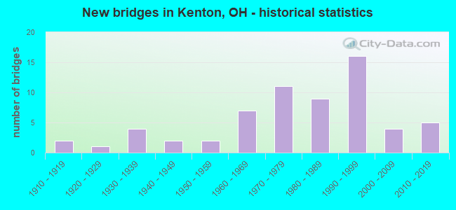
- New bridges - historical statistics
- 21910-1919
- 11920-1929
- 41930-1939
- 21940-1949
- 21950-1959
- 71960-1969
- 111970-1979
- 91980-1989
- 161990-1999
- 42000-2009
- 52010-2019

- Reconstructed bridges - Historical Statistics
- 11960-1969
- 51970-1979
- 11980-1989
- 41990-1999
- 72000-2009
- 12010-2019
- 22020-2022


- Bridge Condition - Deck
- 25.8%Excellent
- 21.0%Very good
- 32.3%Good
- 12.9%Satisfactory
- 3.2%Fair
- 4.8%Poor

- Bridge Condition - Superstructure
- 30.6%Excellent
- 25.8%Very good
- 19.4%Good
- 19.4%Satisfactory
- 1.6%Fair
- 3.2%Poor

- Bridge Condition - Substructure
- 21.0%Excellent
- 40.3%Very good
- 21.0%Good
- 6.5%Satisfactory
- 8.1%Fair
- 3.2%Poor

- Bridge Condition - Channel
- 4.8%Excellent
- 9.7%Very good
- 40.3%Good
- 22.6%Satisfactory
- 16.1%Fair
- 3.2%Poor
- 3.2%Serious
Find on map >> Show street view
Structure Number: 3300129, Location: 0.5 MI WEST OF KENTON (Lat: 40.655661, Lng: -83.633800), Route carried "on" structure: State highway 309, Year Built: 1941, Year Reconstructed: 1970, Status: Open, Structure Length: 9.78m (32.09ft), Average Daily Traffic: 7,134 (year 2015), Truck Traffic: 6%, Average Future Daily Traffic: 9,902 (year 2035), Design Load: H 15, Features Intersected: CONRAIL RAILROAD
Minimum Vertical Clearance: 30+ m (98+ ft), Kilometerpoint: 23.319, Lanes on structure: 2, Base Highway Network: Yes, Owner: State Highway Agency, Approaching Roadway Width: 9.8m (32.2ft), Skew: 5 degrees, Material/Design: Steel continuous, Design/Construction: Stringer/Multi-beam, Number Of Spans In Main Unit: 5, Length of Maximum Span: 21.3m (69.9ft), Curb-To-Curb Width: 10.1m (33.1ft), Out-to-Out Width: 11.1m (36.4ft)
Condition: Deck: Good, Superstructure: Good, Substructure: Good, Operating Rating: 42.1 metric tons, Method Used To Determine Operating Rating: Load Factor (LF) rating reported by rating factor (RF) method using MS18 loading, Inventory Rating: 25.9 metric tons, Method Used To Determine Inventory Rating: Load Factor (LF) rating reported by rating factor (RF) method using MS18 loading, Structural Evaluation: Equal to present minimum criteria, Deck Geometry: Meets minimum limits, Underclear: Superior to present desirable criteria, Approach Roadway Alignment: Better than present minimum criteria, Length Of Structure Improvement: 12.19m (39.99ft), Designated Inspection Frequency: Every 24 months, Inspection Date: June 2021, Bridge Improvement Cost: $90,000, Roadway Improvement Cost: $9,000, Total Project Cost: $130,000, Deck Structure Type: Concrete Cast-file-Place, Wearing Surface/Protective System: Wearing Surface: Low Slump Concrete
Find on map >> Show street view
Structure Number: 3300277, Location: 7.05 mi. North of HAR/UNI (Lat: 40.591269, Lng: -83.567319), Route carried "on" structure: State highway 31, Year Built: 1967, Status: Open, Structure Length: 2.80m (9.19ft), Average Daily Traffic: 4,514 (year 2015), Truck Traffic: 32%, Average Future Daily Traffic: 6,265 (year 2035), Design Load: H 20, Features Intersected: WOLF CREEK
Minimum Vertical Clearance: 30+ m (98+ ft), Kilometerpoint: 11.346, Lanes on structure: 2, Base Highway Network: Yes, Owner: State Highway Agency, Approaching Roadway Width: 9.8m (32.2ft), Material/Design: Concrete continuous, Design/Construction: Slab, Number Of Spans In Main Unit: 3, Length of Maximum Span: 9.8m (32.2ft), Curb-To-Curb Width: 13.4m (44.0ft), Out-to-Out Width: 13.4m (44.0ft)
Condition: Deck: Satisfactory, Superstructure: Satisfactory, Substructure: Satisfactory, Channel: Good, Operating Rating: 58.3 metric tons, Method Used To Determine Operating Rating: Load Factor (LF) rating reported by rating factor (RF) method using MS18 loading, Inventory Rating: 35.6 metric tons, Method Used To Determine Inventory Rating: Load Factor (LF) rating reported by rating factor (RF) method using MS18 loading, Structural Evaluation: Equal to present minimum criteria, Deck Geometry: Better than present minimum criteria, Waterway Adequacy: Equal to present desirable criteria, Approach Roadway Alignment: Equal to present desirable criteria, Designated Inspection Frequency: Every 12 months, Inspection Date: May 2021, Deck Structure Type: Concrete Cast-file-Place, Wearing Surface/Protective System: Wearing Surface: Latex Concrete
Find on map >> Show street view
Structure Number: 3300315, Location: 1.5 SOUTH OF KENTON (Lat: 40.618731, Lng: -83.589500), Route carried "on" structure: State highway 31, Year Built: 2000, Status: Open, Structure Length: 2.32m (7.61ft), Average Daily Traffic: 4,514 (year 2018), Truck Traffic: 32%, Average Future Daily Traffic: 6,265 (year 2038), Design Load: HS 20+Mod, Features Intersected: GANDER RUN
Minimum Vertical Clearance: 30+ m (98+ ft), Kilometerpoint: 14.935, Lanes on structure: 2, Base Highway Network: Yes, Owner: State Highway Agency, Approaching Roadway Width: 14.4m (47.2ft), Skew: 5 degrees, Material/Design: Steel, Design/Construction: Stringer/Multi-beam, Number Of Spans In Main Unit: 1, Length of Maximum Span: 22.2m (72.8ft), Curb-To-Curb Width: 14.4m (47.2ft), Out-to-Out Width: 14.4m (47.2ft)
Condition: Deck: Very good, Superstructure: Excellent, Substructure: Excellent, Channel: Good, Operating Rating: 42.1 metric tons, Method Used To Determine Operating Rating: Load Factor (LF) rating reported by rating factor (RF) method using MS18 loading, Inventory Rating: 32.4 metric tons, Method Used To Determine Inventory Rating: Load Factor (LF) rating reported by rating factor (RF) method using MS18 loading, Structural Evaluation: Equal to present desirable criteria, Deck Geometry: Superior to present desirable criteria, Waterway Adequacy: Superior to present desirable criteria, Approach Roadway Alignment: Superior to present desirable criteria, Designated Inspection Frequency: Every 24 months, Inspection Date: June 2021, Deck Structure Type: Concrete Cast-file-Place, Wearing Surface/Protective System: Wearing Surface: Monolithic Concrete, Deck Protection: Epoxy Coated Reinforcing
Find on map >> Show street view
Structure Number: 3300366, Location: 0.45 mi. North of SR53 (Lat: 40.643000, Lng: -83.608189), Route carried "on" structure: State highway 31, Year Built: 1968, Status: Open, Structure Length: 4.42m (14.50ft), Average Daily Traffic: 9,687 (year 2018), Truck Traffic: 27%, Average Future Daily Traffic: 13,446 (year 2038), Design Load: H 20, Features Intersected: SCIOTO RIVER #
Minimum Vertical Clearance: 30+ m (98+ ft), Kilometerpoint: 18.073, Lanes on structure: 4, Base Highway Network: Yes, Owner: State Highway Agency, Approaching Roadway Width: 15.9m (52.2ft), Material/Design: Prestressed concrete continuous, Design/Construction: Stringer/Multi-beam, Number Of Spans In Main Unit: 3, Length of Maximum Span: 13.7m (44.9ft), Curb or Sidewalk Widths: Left: 1.8m (5.9ft), Right: 1.8m (5.9ft), Curb-To-Curb Width: 15.9m (52.2ft), Out-to-Out Width: 20.2m (66.3ft)
Condition: Deck: Good, Superstructure: Excellent, Substructure: Very good, Channel: Satisfactory, Operating Rating: 42.1 metric tons, Method Used To Determine Operating Rating: Load Factor (LF) rating reported by rating factor (RF) method using MS18 loading, Inventory Rating: 32.4 metric tons, Method Used To Determine Inventory Rating: Load Factor (LF) rating reported by rating factor (RF) method using MS18 loading, Structural Evaluation: Equal to present desirable criteria, Deck Geometry: Meets minimum limits, Waterway Adequacy: Equal to present desirable criteria, Approach Roadway Alignment: Equal to present desirable criteria, Length Of Structure Improvement: 4.57m (14.99ft), Designated Inspection Frequency: Every 24 months, Inspection Date: June 2021, Bridge Improvement Cost: $63,000, Roadway Improvement Cost: $6,000, Total Project Cost: $70,000, Deck Structure Type: Concrete Cast-file-Place, Wearing Surface/Protective System: Wearing Surface: Integral Concrete
Find on map >> Show street view
Structure Number: 3300404, Location: 2.47 mi. North of SR309 (Lat: 40.679761, Lng: -83.591850), Route carried "on" structure: State highway 53, Year Built: 1983, Year Reconstructed: 2012, Status: Open, Structure Length: 0.85m (2.79ft), Average Daily Traffic: 2,054 (year 2015), Truck Traffic: 10%, Average Future Daily Traffic: 2,851 (year 2035), Design Load: HS 20+Mod, Features Intersected: BLOOM DITCH
Minimum Vertical Clearance: 30+ m (98+ ft), Kilometerpoint: 4.748, Lanes on structure: 2, Owner: State Highway Agency, Approaching Roadway Width: 13.4m (44.0ft), Skew: 2 degrees, Material/Design: Prestressed concrete, Design/Construction: Box Beam or Girders - Multiple, Number Of Spans In Main Unit: 1, Length of Maximum Span: 7.9m (25.9ft), Curb-To-Curb Width: 13.4m (44.0ft), Out-to-Out Width: 13.4m (44.0ft)
Condition: Deck: Excellent, Superstructure: Excellent, Substructure: Very good, Channel: Very good, Operating Rating: 74.5 metric tons, Method Used To Determine Operating Rating: Load Factor (LF) rating reported by rating factor (RF) method using MS18 loading, Inventory Rating: 45.4 metric tons, Method Used To Determine Inventory Rating: Load Factor (LF) rating reported by rating factor (RF) method using MS18 loading, Structural Evaluation: Equal to present desirable criteria, Deck Geometry: Better than present minimum criteria, Waterway Adequacy: Equal to present desirable criteria, Approach Roadway Alignment: Equal to present desirable criteria, Designated Inspection Frequency: Every 24 months, Inspection Date: June 2021, Deck Structure Type: Concrete Cast-file-Place, Wearing Surface/Protective System: Wearing Surface: Monolithic Concrete, Deck Protection: Epoxy Coated Reinforcing
Find on map >> Show street view
Structure Number: 3300587, Location: 2.8 mi. South of USR68 (Lat: 40.624619, Lng: -83.649389), Route carried "on" structure: State highway 67, Year Built: 1983, Status: Open, Structure Length: 2.19m (7.19ft), Average Daily Traffic: 739 (year 2015), Truck Traffic: 11%, Average Future Daily Traffic: 1,026 (year 2035), Design Load: HS 20+Mod, Features Intersected: SILVER CREEK
Minimum Vertical Clearance: 30+ m (98+ ft), Kilometerpoint: 21.131, Lanes on structure: 2, Owner: State Highway Agency, Approaching Roadway Width: 12.2m (40.0ft), Skew: 2 degrees, Material/Design: Prestressed concrete, Design/Construction: Box Beam or Girders - Multiple, Number Of Spans In Main Unit: 1, Length of Maximum Span: 21.3m (69.9ft), Curb-To-Curb Width: 12.2m (40.0ft), Out-to-Out Width: 12.2m (40.0ft)
Condition: Deck: Very good, Superstructure: Very good, Substructure: Very good, Channel: Excellent, Operating Rating: 74.5 metric tons, Method Used To Determine Operating Rating: Load Factor (LF) rating reported by rating factor (RF) method using MS18 loading, Inventory Rating: 25.9 metric tons, Method Used To Determine Inventory Rating: Load Factor (LF) rating reported by rating factor (RF) method using MS18 loading, Structural Evaluation: Equal to present minimum criteria, Deck Geometry: Equal to present desirable criteria, Waterway Adequacy: Equal to present desirable criteria, Approach Roadway Alignment: Equal to present desirable criteria, Designated Inspection Frequency: Every 24 months, Inspection Date: June 2021, Deck Structure Type: Other, Wearing Surface/Protective System: Wearing Surface: Bituminous, Deck Protection: Epoxy Coated Reinforcing
Find on map >> Show street view
Structure Number: 3300617, Location: WEST EDGE OF KENTON (Lat: 40.637869, Lng: -83.617300), Route carried "on" structure: State highway 67, Year Built: 2000, Status: Open, Structure Length: 2.62m (8.60ft), Average Daily Traffic: 739 (year 2015), Truck Traffic: 11%, Average Future Daily Traffic: 1,026 (year 2035), Design Load: HS 20+Mod, Features Intersected: TAYLOR CREEK
Minimum Vertical Clearance: 30+ m (98+ ft), Kilometerpoint: 24.172, Lanes on structure: 2, Owner: State Highway Agency, Approaching Roadway Width: 11.6m (38.1ft), Material/Design: Concrete continuous, Design/Construction: Slab, Number Of Spans In Main Unit: 3, Length of Maximum Span: 10.1m (33.1ft), Curb-To-Curb Width: 11.6m (38.1ft), Out-to-Out Width: 11.6m (38.1ft)
Condition: Deck: Very good, Superstructure: Very good, Substructure: Very good, Channel: Excellent, Operating Rating: 42.1 metric tons, Method Used To Determine Operating Rating: Load Factor (LF) rating reported by rating factor (RF) method using MS18 loading, Inventory Rating: 32.4 metric tons, Method Used To Determine Inventory Rating: Load Factor (LF) rating reported by rating factor (RF) method using MS18 loading, Structural Evaluation: Equal to present desirable criteria, Deck Geometry: Better than present minimum criteria, Waterway Adequacy: Superior to present desirable criteria, Approach Roadway Alignment: Equal to present desirable criteria, Designated Inspection Frequency: Every 24 months, Inspection Date: June 2021, Deck Structure Type: Concrete Cast-file-Place, Wearing Surface/Protective System: Wearing Surface: Monolithic Concrete, Deck Protection: Epoxy Coated Reinforcing
Find on map >> Show street view
Structure Number: 3300625, Location: 4.72 mi. North of USR68 (Lat: 40.674650, Lng: -83.528619), Route carried "on" structure: State highway 67, Year Built: 1983, Status: Open, Structure Length: 1.65m (5.41ft), Average Daily Traffic: 1,723 (year 2015), Truck Traffic: 16%, Average Future Daily Traffic: 2,392 (year 2035), Design Load: HS 20+Mod, Features Intersected: REEVHORN RUN
Minimum Vertical Clearance: 30+ m (98+ ft), Kilometerpoint: 33.185, Lanes on structure: 2, Owner: State Highway Agency, Approaching Roadway Width: 12.2m (40.0ft), Material/Design: Prestressed concrete, Design/Construction: Box Beam or Girders - Multiple, Number Of Spans In Main Unit: 1, Length of Maximum Span: 15.9m (52.2ft), Curb-To-Curb Width: 12.2m (40.0ft), Out-to-Out Width: 12.2m (40.0ft)
Condition: Deck: Very good, Superstructure: Good, Substructure: Good, Channel: Very good, Operating Rating: 42.1 metric tons, Method Used To Determine Operating Rating: Load Factor (LF) rating reported by rating factor (RF) method using MS18 loading, Inventory Rating: 32.4 metric tons, Method Used To Determine Inventory Rating: Load Factor (LF) rating reported by rating factor (RF) method using MS18 loading, Structural Evaluation: Better than present minimum criteria, Deck Geometry: Better than present minimum criteria, Waterway Adequacy: Equal to present desirable criteria, Approach Roadway Alignment: Equal to present desirable criteria, Designated Inspection Frequency: Every 24 months, Inspection Date: May 2021, Deck Structure Type: Other, Wearing Surface/Protective System: Wearing Surface: Bituminous, Deck Protection: Epoxy Coated Reinforcing
Find on map >> Show street view
Structure Number: 3300676, Location: 3.36 mi. North of USR68 (Lat: 40.666231, Lng: -83.552189), Route carried "on" structure: State highway 67, Year Built: 1983, Status: Open, Structure Length: 1.89m (6.20ft), Average Daily Traffic: 1,723 (year 2015), Truck Traffic: 16%, Average Future Daily Traffic: 2,392 (year 2035), Design Load: HS 20+Mod, Features Intersected: TYMOCHTEE CREEK
Minimum Vertical Clearance: 30+ m (98+ ft), Kilometerpoint: 30.996, Lanes on structure: 2, Owner: State Highway Agency, Approaching Roadway Width: 12.2m (40.0ft), Skew: 2 degrees, Material/Design: Prestressed concrete, Design/Construction: Box Beam or Girders - Multiple, Number Of Spans In Main Unit: 1, Length of Maximum Span: 18.3m (60.0ft), Curb-To-Curb Width: 12.2m (40.0ft), Out-to-Out Width: 12.2m (40.0ft)
Condition: Deck: Very good, Superstructure: Good, Substructure: Good, Channel: Very good, Operating Rating: 42.1 metric tons, Method Used To Determine Operating Rating: Load Factor (LF) rating reported by rating factor (RF) method using MS18 loading, Inventory Rating: 32.4 metric tons, Method Used To Determine Inventory Rating: Load Factor (LF) rating reported by rating factor (RF) method using MS18 loading, Structural Evaluation: Better than present minimum criteria, Deck Geometry: Better than present minimum criteria, Waterway Adequacy: Equal to present desirable criteria, Approach Roadway Alignment: Equal to present desirable criteria, Designated Inspection Frequency: Every 24 months, Inspection Date: May 2021, Deck Structure Type: Other, Wearing Surface/Protective System: Wearing Surface: Bituminous, Deck Protection: Epoxy Coated Reinforcing
Find on map >> Show street view
Structure Number: 3300757, Location: 1.24 mi. South of USR68 (Lat: 40.630411, Lng: -83.616489), Route carried "on" structure: US 68, Year Built: 1962, Year Reconstructed: 2012, Status: Open, Structure Length: 2.59m (8.50ft), Average Daily Traffic: 8,002 (year 2018), Truck Traffic: 18%, Average Future Daily Traffic: 11,107 (year 2038), Design Load: HS 20, Features Intersected: TAYLOR CREEK
Minimum Vertical Clearance: 30+ m (98+ ft), Kilometerpoint: 13.583, Lanes on structure: 2, Base Highway Network: Yes, Owner: State Highway Agency, Approaching Roadway Width: 7.3m (24.0ft), Material/Design: Concrete continuous, Design/Construction: Slab, Number Of Spans In Main Unit: 3, Length of Maximum Span: 9.1m (29.9ft), Curb-To-Curb Width: 13.4m (44.0ft), Out-to-Out Width: 13.4m (44.0ft)
Condition: Deck: Good, Superstructure: Good, Substructure: Good, Channel: Very good, Operating Rating: 58.3 metric tons, Method Used To Determine Operating Rating: Load Factor (LF) rating reported by rating factor (RF) method using MS18 loading, Inventory Rating: 35.6 metric tons, Method Used To Determine Inventory Rating: Load Factor (LF) rating reported by rating factor (RF) method using MS18 loading, Structural Evaluation: Better than present minimum criteria, Deck Geometry: Equal to present minimum criteria, Waterway Adequacy: Equal to present desirable criteria, Approach Roadway Alignment: Equal to present desirable criteria, Designated Inspection Frequency: Every 24 months, Inspection Date: June 2021, Deck Structure Type: Concrete Cast-file-Place, Wearing Surface/Protective System: Wearing Surface: Integral Concrete, Membrane: Built-up
Find on map >> Show street view
Structure Number: 3300773, Location: 0.28 mi. South of USR68 (Lat: 40.643231, Lng: -83.609481), Route carried "on" structure: US 68, Year Built: 1983, Year Reconstructed: 2013, Status: Open, Structure Length: 4.61m (15.12ft), Average Daily Traffic: 7,361 (year 2015), Truck Traffic: 19%, Average Future Daily Traffic: 10,217 (year 2035), Design Load: HS 20+Mod, Features Intersected: SCIOTO RIVER #
Minimum Vertical Clearance: 30+ m (98+ ft), Kilometerpoint: 15.128, Lanes on structure: 2, Base Highway Network: Yes, Owner: State Highway Agency, Approaching Roadway Width: 8.5m (27.9ft), Skew: 1 degrees, Material/Design: Prestressed concrete continuous, Design/Construction: Box Beam or Girders - Multiple, Number Of Spans In Main Unit: 3, Length of Maximum Span: 16.8m (55.1ft), Curb or Sidewalk Widths: Left: 1.8m (5.9ft), Right: 1.8m (5.9ft), Curb-To-Curb Width: 8.5m (27.9ft), Out-to-Out Width: 12.8m (42.0ft)
Condition: Deck: Excellent, Superstructure: Excellent, Substructure: Excellent, Channel: Good, Operating Rating: 42.1 metric tons, Method Used To Determine Operating Rating: Load Factor (LF) rating reported by rating factor (RF) method using MS18 loading, Inventory Rating: 32.4 metric tons, Method Used To Determine Inventory Rating: Load Factor (LF) rating reported by rating factor (RF) method using MS18 loading, Structural Evaluation: Equal to present desirable criteria, Deck Geometry: High priority of replacement, Waterway Adequacy: Equal to present desirable criteria, Approach Roadway Alignment: Equal to present desirable criteria, Designated Inspection Frequency: Every 24 months, Inspection Date: June 2021, Deck Structure Type: Concrete Cast-file-Place, Wearing Surface/Protective System: Wearing Surface: Monolithic Concrete, Deck Protection: Epoxy Coated Reinforcing
Find on map >> Show street view
Structure Number: 3300854, Location: 2.5 N OF KENTON (Lat: 40.694561, Lng: -83.617850), Route carried "on" structure: US 68, Year Built: 1996, Status: Open, Structure Length: 0.67m (2.20ft), Average Daily Traffic: 5,889 (year 2018), Truck Traffic: 30%, Average Future Daily Traffic: 8,174 (year 2038), Design Load: HS 20+Mod, Features Intersected: INTERMITTENT WATERWAY
Minimum Vertical Clearance: 30+ m (98+ ft), Kilometerpoint: 20.921, Lanes on structure: 2, Base Highway Network: Yes, Owner: State Highway Agency, Approaching Roadway Width: 9.1m (29.9ft), Skew: 2 degrees, Material/Design: Concrete, Design/Construction: Culvert, Number Of Spans In Main Unit: 1, Length of Maximum Span: 6.1m (20.0ft)
Condition: Channel: Excellent, Culverts: Excellent, Operating Rating: 42.1 metric tons, Method Used To Determine Operating Rating: Load Factor (LF) rating reported by rating factor (RF) method using MS18 loading, Inventory Rating: 32.4 metric tons, Method Used To Determine Inventory Rating: Load Factor (LF) rating reported by rating factor (RF) method using MS18 loading, Structural Evaluation: Equal to present desirable criteria, Waterway Adequacy: Superior to present desirable criteria, Approach Roadway Alignment: Superior to present desirable criteria, Designated Inspection Frequency: Every 24 months, Inspection Date: June 2021
Find on map >> Show street view
Structure Number: 3300889, Location: 5.14 mi. North of USR68 (Lat: 40.716261, Lng: -83.623531), Route carried "on" structure: US 68, Year Built: 1988, Status: Open, Structure Length: 2.26m (7.41ft), Average Daily Traffic: 5,889 (year 2015), Truck Traffic: 30%, Average Future Daily Traffic: 8,174 (year 2035), Design Load: HS 20+Mod, Features Intersected: CESSNA CREEK
Minimum Vertical Clearance: 30+ m (98+ ft), Kilometerpoint: 23.400, Lanes on structure: 2, Base Highway Network: Yes, Owner: State Highway Agency, Approaching Roadway Width: 13.4m (44.0ft), Skew: 1 degrees, Material/Design: Prestressed concrete, Design/Construction: Box Beam or Girders - Multiple, Number Of Spans In Main Unit: 1, Length of Maximum Span: 21.3m (69.9ft), Curb-To-Curb Width: 13.4m (44.0ft), Out-to-Out Width: 13.4m (44.0ft)
Condition: Deck: Good, Superstructure: Good, Substructure: Excellent, Channel: Good, Operating Rating: 55.1 metric tons, Method Used To Determine Operating Rating: Load Factor (LF) rating reported by rating factor (RF) method using MS18 loading, Inventory Rating: 32.4 metric tons, Method Used To Determine Inventory Rating: Load Factor (LF) rating reported by rating factor (RF) method using MS18 loading, Structural Evaluation: Better than present minimum criteria, Deck Geometry: Equal to present minimum criteria, Waterway Adequacy: Equal to present desirable criteria, Approach Roadway Alignment: Equal to present desirable criteria, Designated Inspection Frequency: Every 24 months, Inspection Date: June 2021, Deck Structure Type: Other, Wearing Surface/Protective System: Wearing Surface: Bituminous, Deck Protection: Epoxy Coated Reinforcing
Find on map >> Show street view
Structure Number: 3330419, Location: .1 MI E OF TWP 199 (Lat: 40.620000, Lng: -83.526881), Route carried "on" structure: County highway T0146, Year Built: 1998, Status: Open, Structure Length: 1.52m (4.99ft), Average Daily Traffic: 324 (year 2015), Truck Traffic: 7%, Average Future Daily Traffic: 450 (year 2035), Design Load: HS 20, Features Intersected: WOLF CREEK, Facility Carried by Structure: TOWNSHIP ROAD 146
Minimum Vertical Clearance: 30+ m (98+ ft), Kilometerpoint: 29.773, Lanes on structure: 2, Owner: County Highway Agency, Approaching Roadway Width: 4.6m (15.1ft), Material/Design: Steel, Design/Construction: Stringer/Multi-beam, Number Of Spans In Main Unit: 1, Length of Maximum Span: 14.3m (46.9ft), Curb-To-Curb Width: 7.3m (24.0ft), Out-to-Out Width: 7.3m (24.0ft)
Condition: Deck: Excellent, Superstructure: Excellent, Substructure: Excellent, Channel: Satisfactory, Operating Rating: 42.1 metric tons, Method Used To Determine Operating Rating: Allowable Stress (AS) rating reported by rating factor (RF) method using MS18 loading, Inventory Rating: 32.4 metric tons, Method Used To Determine Inventory Rating: Allowable Stress (AS) rating reported by rating factor (RF) method using MS18 loading, Structural Evaluation: Equal to present desirable criteria, Deck Geometry: Somewhat better than minimum adequacy, Waterway Adequacy: Better than present minimum criteria, Approach Roadway Alignment: Better than present minimum criteria, Designated Inspection Frequency: Every 24 months, Inspection Date: August 2020, Deck Structure Type: Corrugated Steel, Wearing Surface/Protective System: Wearing Surface: Bituminous
Find on map >> Show street view
Structure Number: 3330796, Location: .25 MI. S. OF CR 144 (Lat: 40.623200, Lng: -83.538461), Route carried "on" structure: County highway C0195, Year Built: 1990, Year Reconstructed: 2007, Status: Open, Structure Length: 4.75m (15.58ft), Average Daily Traffic: 325 (year 2015), Truck Traffic: 7%, Average Future Daily Traffic: 451 (year 2035), Design Load: HS 20, Features Intersected: SCIOTO RIVER, Facility Carried by Structure: COUNTY ROAD 195
Minimum Vertical Clearance: 30+ m (98+ ft), Kilometerpoint: 12.875, Lanes on structure: 2, Owner: County Highway Agency, Approaching Roadway Width: 5.8m (19.0ft), Material/Design: Steel, Design/Construction: Truss - Thru, Number Of Spans In Main Unit: 1, Number Of Approach Spans: 1, Length of Maximum Span: 39.3m (128.9ft), Curb-To-Curb Width: 7.3m (24.0ft), Out-to-Out Width: 7.6m (24.9ft)
Condition: Deck: Excellent, Superstructure: Excellent, Substructure: Excellent, Channel: Good, Operating Rating: 48.6 metric tons, Method Used To Determine Operating Rating: Load Factor (LF) rating reported by rating factor (RF) method using MS18 loading, Inventory Rating: 29.2 metric tons, Method Used To Determine Inventory Rating: Load Factor (LF) rating reported by rating factor (RF) method using MS18 loading, Structural Evaluation: Better than present minimum criteria, Deck Geometry: Somewhat better than minimum adequacy, Waterway Adequacy: Better than present minimum criteria, Approach Roadway Alignment: Equal to present desirable criteria, Designated Inspection Frequency: Every 12 months, Critical Feature Inspection Frequency: Every 24 months, Inspection Date: August 2021, Critical Feature Inspection Date: August 2021, Deck Structure Type: Corrugated Steel, Wearing Surface/Protective System: Wearing Surface: Bituminous
Find on map >> Show street view
Structure Number: 333085, Location: .4 MI S OF JCT OF TWP 146 (Lat: 40.614911, Lng: -83.527869), Route carried "on" structure: County highway 199, Year Built: 1998, Status: Open, Structure Length: 1.13m (3.71ft), Average Daily Traffic: 324 (year 2015), Truck Traffic: 7%, Average Future Daily Traffic: 450 (year 2035), Design Load: HS 20, Features Intersected: WOLF CREEK
Minimum Vertical Clearance: 30+ m (98+ ft), Kilometerpoint: 11.668, Lanes on structure: 2, Owner: County Highway Agency, Approaching Roadway Width: 4.0m (13.1ft), Material/Design: Steel, Design/Construction: Stringer/Multi-beam, Number Of Spans In Main Unit: 1, Length of Maximum Span: 10.7m (35.1ft), Curb-To-Curb Width: 7.3m (24.0ft), Out-to-Out Width: 7.3m (24.0ft)
Condition: Deck: Very good, Superstructure: Very good, Substructure: Very good, Channel: Fair, Operating Rating: 55.1 metric tons, Method Used To Determine Operating Rating: Load Factor (LF) rating reported by rating factor (RF) method using MS18 loading, Inventory Rating: 32.4 metric tons, Method Used To Determine Inventory Rating: Load Factor (LF) rating reported by rating factor (RF) method using MS18 loading, Structural Evaluation: Equal to present desirable criteria, Deck Geometry: Somewhat better than minimum adequacy, Waterway Adequacy: Better than present minimum criteria, Approach Roadway Alignment: Equal to present desirable criteria, Designated Inspection Frequency: Every 24 months, Inspection Date: August 2020, Deck Structure Type: Corrugated Steel, Wearing Surface/Protective System: Wearing Surface: Bituminous
Find on map >> Show street view
Structure Number: 33325, Location: .17 MI S OF JCT OF CR 144 (Lat: 40.621481, Lng: -83.530311), Route carried "on" structure: County highway 199, Year Built: 1994, Status: Posted for load, Structure Length: 6.52m (21.39ft), Average Daily Traffic: 324 (year 2015), Truck Traffic: 7%, Average Future Daily Traffic: 450 (year 2035), Design Load: HS 20, Features Intersected: SCIOTO RIVER
Minimum Vertical Clearance: 30+ m (98+ ft), Kilometerpoint: 13.583, Lanes on structure: 2, Owner: County Highway Agency, Approaching Roadway Width: 6.1m (20.0ft), Skew: 6 degrees, Material/Design: Steel, Design/Construction: Truss - Thru, Number Of Spans In Main Unit: 1, Number Of Approach Spans: 2, Length of Maximum Span: 45.7m (149.9ft), Curb-To-Curb Width: 7.3m (24.0ft), Out-to-Out Width: 7.6m (24.9ft)
Condition: Deck: Good, Superstructure: Very good, Substructure: Very good, Channel: Fair, Operating Rating: 35.6 metric tons, Method Used To Determine Operating Rating: Allowable Stress (AS) rating reported by rating factor (RF) method using MS18 loading, Inventory Rating: 13.0 metric tons, Method Used To Determine Inventory Rating: Allowable Stress (AS) rating reported by rating factor (RF) method using MS18 loading, Structural Evaluation: Meets minimum limits, Deck Geometry: Somewhat better than minimum adequacy, Waterway Adequacy: Better than present minimum criteria, Approach Roadway Alignment: Equal to present minimum criteria, Bridge Posting: Required (Relationship of Operating Rating to Maximum Legal Load: 10.0 - 19.9% below), Designated Inspection Frequency: Every 12 months, Critical Feature Inspection Frequency: Every 24 months, Inspection Date: July 2021, Critical Feature Inspection Date: July 2021, Deck Structure Type: Corrugated Steel, Wearing Surface/Protective System: Wearing Surface: Bituminous
Find on map >> Show street view
Structure Number: 3333183, Location: .3 MI W OF JCT OF TWP 125 (Lat: 40.666919, Lng: -83.679839), Route carried "on" structure: County highway C0106, Year Built: 1974, Status: Open, Structure Length: 6.98m (22.90ft), Average Daily Traffic: 291 (year 2015), Truck Traffic: 8%, Average Future Daily Traffic: 404 (year 2035), Design Load: H 20, Features Intersected: SCIOTO RIVER, Facility Carried by Structure: COUNTY ROAD 106
Minimum Vertical Clearance: 30+ m (98+ ft), Kilometerpoint: 16.737, Lanes on structure: 2, Owner: County Highway Agency, Approaching Roadway Width: 5.8m (19.0ft), Skew: 6 degrees, Material/Design: Steel continuous, Design/Construction: Stringer/Multi-beam, Number Of Spans In Main Unit: 4, Length of Maximum Span: 18.3m (60.0ft), Curb-To-Curb Width: 8.5m (27.9ft), Out-to-Out Width: 8.5m (27.9ft)
Condition: Deck: Good, Superstructure: Good, Substructure: Very good, Channel: Fair, Operating Rating: 42.1 metric tons, Method Used To Determine Operating Rating: Load Factor (LF) rating reported by rating factor (RF) method using MS18 loading, Inventory Rating: 38.9 metric tons, Method Used To Determine Inventory Rating: Load Factor (LF) rating reported by rating factor (RF) method using MS18 loading, Structural Evaluation: Better than present minimum criteria, Deck Geometry: Equal to present minimum criteria, Waterway Adequacy: Better than present minimum criteria, Approach Roadway Alignment: Better than present minimum criteria, Designated Inspection Frequency: Every 24 months, Inspection Date: October 2020, Deck Structure Type: Concrete Cast-file-Place, Wearing Surface/Protective System: Wearing Surface: Bituminous
Find on map >> Show street view
Structure Number: 3333671, Location: .6 MI E OF JCT OF C R 115 (Lat: 40.589919, Lng: -83.662669), Route carried "on" structure: County highway T0180, Year Built: 1965, Status: Open, Structure Length: 0.91m (2.99ft), Average Daily Traffic: 324 (year 2015), Truck Traffic: 7%, Average Future Daily Traffic: 450 (year 2035), Design Load: HS 20, Features Intersected: SILVER CREEK, Facility Carried by Structure: TOWNSHIP ROAD 180
Minimum Vertical Clearance: 30+ m (98+ ft), Kilometerpoint: 18.507, Lanes on structure: 2, Owner: County Highway Agency, Approaching Roadway Width: 5.2m (17.1ft), Material/Design: Steel, Design/Construction: Stringer/Multi-beam, Number Of Spans In Main Unit: 1, Length of Maximum Span: 7.3m (24.0ft), Curb-To-Curb Width: 7.2m (23.6ft), Out-to-Out Width: 7.3m (24.0ft)
Condition: Deck: Good, Superstructure: Satisfactory, Substructure: Very good, Channel: Good, Operating Rating: 87.5 metric tons, Method Used To Determine Operating Rating: Load Factor (LF) rating reported by rating factor (RF) method using MS18 loading, Inventory Rating: 51.8 metric tons, Method Used To Determine Inventory Rating: Load Factor (LF) rating reported by rating factor (RF) method using MS18 loading, Structural Evaluation: Equal to present minimum criteria, Deck Geometry: Meets minimum limits, Waterway Adequacy: Equal to present desirable criteria, Approach Roadway Alignment: Equal to present desirable criteria, Designated Inspection Frequency: Every 12 months, Inspection Date: September 2021, Deck Structure Type: Concrete Cast-file-Place, Wearing Surface/Protective System: Wearing Surface: Bituminous
Find on map >> Show street view
Structure Number: 3333795, Location: .1 MI N OF JCT OF TWP 120 (Lat: 40.661439, Lng: -83.673850), Route carried "on" structure: County highway T0115, Year Built: 2003, Status: Open, Structure Length: 3.78m (12.40ft), Average Daily Traffic: 241 (year 2015), Truck Traffic: 7%, Average Future Daily Traffic: 335 (year 2035), Design Load: HS 20, Features Intersected: SCIOTO RIVER, Facility Carried by Structure: TOWNSHIP ROAD 115
Minimum Vertical Clearance: 30+ m (98+ ft), Kilometerpoint: 15.611, Lanes on structure: 2, Owner: County Highway Agency, Approaching Roadway Width: 4.6m (15.1ft), Material/Design: Steel, Design/Construction: Truss - Thru, Number Of Spans In Main Unit: 1, Length of Maximum Span: 36.6m (120.1ft), Curb-To-Curb Width: 7.9m (25.9ft), Out-to-Out Width: 8.2m (26.9ft)
Condition: Deck: Very good, Superstructure: Excellent, Substructure: Excellent, Channel: Satisfactory, Operating Rating: 48.6 metric tons, Method Used To Determine Operating Rating: Allowable Stress (AS) rating reported by rating factor (RF) method using MS18 loading, Inventory Rating: 25.9 metric tons, Method Used To Determine Inventory Rating: Allowable Stress (AS) rating reported by rating factor (RF) method using MS18 loading, Structural Evaluation: Equal to present minimum criteria, Deck Geometry: Somewhat better than minimum adequacy, Waterway Adequacy: Better than present minimum criteria, Approach Roadway Alignment: Equal to present minimum criteria, Designated Inspection Frequency: Every 12 months, Critical Feature Inspection Frequency: Every 24 months, Inspection Date: September 2021, Critical Feature Inspection Date: September 2021, Deck Structure Type: Corrugated Steel, Wearing Surface/Protective System: Wearing Surface: Bituminous
Find on map >> Show street view
Structure Number: 3339319, Location: .1 MI E OF JCT OF SR 68 (Lat: 40.718200, Lng: -83.622411), Route carried "on" structure: County highway C0080, Year Built: 1971, Year Reconstructed: 2001, Status: Open, Structure Length: 1.10m (3.61ft), Average Daily Traffic: 477 (year 2018), Truck Traffic: 8%, Average Future Daily Traffic: 662 (year 2038), Design Load: H 15, Features Intersected: CESSNA CREEK, Facility Carried by Structure: COUNTY ROAD 80
Minimum Vertical Clearance: 30+ m (98+ ft), Kilometerpoint: 21.565, Lanes on structure: 2, Owner: County Highway Agency, Approaching Roadway Width: 5.5m (18.0ft), Material/Design: Steel, Design/Construction: Stringer/Multi-beam, Number Of Spans In Main Unit: 1, Length of Maximum Span: 9.8m (32.2ft), Curb-To-Curb Width: 7.3m (24.0ft), Out-to-Out Width: 7.3m (24.0ft)
Condition: Deck: Satisfactory, Superstructure: Very good, Substructure: Very good, Channel: Fair, Operating Rating: 42.1 metric tons, Method Used To Determine Operating Rating: Allowable Stress (AS) rating reported by rating factor (RF) method using MS18 loading, Inventory Rating: 32.4 metric tons, Method Used To Determine Inventory Rating: Allowable Stress (AS) rating reported by rating factor (RF) method using MS18 loading, Structural Evaluation: Equal to present desirable criteria, Deck Geometry: Meets minimum limits, Waterway Adequacy: Equal to present desirable criteria, Approach Roadway Alignment: Equal to present desirable criteria, Designated Inspection Frequency: Every 12 months, Inspection Date: May 2021, Deck Structure Type: Corrugated Steel, Wearing Surface/Protective System: Wearing Surface: Bituminous
Find on map >> Show street view
Structure Number: 3339475, Location: .1 MI E OF JCT OF CR 167 (Lat: 40.717400, Lng: -83.588019), Route carried "on" structure: County highway C0080, Year Built: 1956, Year Reconstructed: 1984, Status: Open, Structure Length: 0.97m (3.18ft), Average Daily Traffic: 477 (year 2018), Truck Traffic: 8%, Average Future Daily Traffic: 662 (year 2038), Design Load: HS 20, Features Intersected: BLANCHARD RIVER, Facility Carried by Structure: COUNTY ROAD 80
Minimum Vertical Clearance: 30+ m (98+ ft), Kilometerpoint: 24.945, Lanes on structure: 2, Owner: County Highway Agency, Approaching Roadway Width: 5.5m (18.0ft), Material/Design: Steel, Design/Construction: Stringer/Multi-beam, Number Of Spans In Main Unit: 1, Length of Maximum Span: 8.9m (29.2ft), Curb-To-Curb Width: 6.7m (22.0ft), Out-to-Out Width: 6.9m (22.6ft)
Condition: Deck: Satisfactory, Superstructure: Fair, Substructure: Fair, Channel: Satisfactory, Operating Rating: 45.4 metric tons, Method Used To Determine Operating Rating: Allowable Stress (AS) rating reported by rating factor (RF) method using MS18 loading, Inventory Rating: 29.2 metric tons, Method Used To Determine Inventory Rating: Allowable Stress (AS) rating reported by rating factor (RF) method using MS18 loading, Structural Evaluation: Somewhat better than minimum adequacy, Deck Geometry: Meets minimum limits, Waterway Adequacy: Better than present minimum criteria, Approach Roadway Alignment: Equal to present desirable criteria, Designated Inspection Frequency: Every 12 months, Inspection Date: May 2021, Deck Structure Type: Wood or Timber, Wearing Surface/Protective System: Wearing Surface: Bituminous
Find on map >> Show street view
Structure Number: 3339521, Location: .8 MI N OF JCT OF CR 90 (Lat: 40.715750, Lng: -83.653261), Route carried "on" structure: County highway C0135, Year Built: 1963, Status: Open, Structure Length: 0.82m (2.69ft), Average Daily Traffic: 381 (year 2015), Truck Traffic: 8%, Average Future Daily Traffic: 529 (year 2035), Design Load: HS 20, Features Intersected: CESSNA CREEK, Facility Carried by Structure: COUNTY ROAD 135
Minimum Vertical Clearance: 30+ m (98+ ft), Kilometerpoint: 21.726, Lanes on structure: 2, Owner: County Highway Agency, Approaching Roadway Width: 5.8m (19.0ft), Material/Design: Steel, Design/Construction: Stringer/Multi-beam, Number Of Spans In Main Unit: 1, Length of Maximum Span: 7.3m (24.0ft), Curb-To-Curb Width: 8.5m (27.9ft), Out-to-Out Width: 8.5m (27.9ft)
Condition: Deck: Good, Superstructure: Satisfactory, Substructure: Poor, Channel: Poor, Operating Rating: 55.1 metric tons, Method Used To Determine Operating Rating: Load Factor (LF) rating reported by rating factor (RF) method using MS18 loading, Inventory Rating: 32.4 metric tons, Method Used To Determine Inventory Rating: Load Factor (LF) rating reported by rating factor (RF) method using MS18 loading, Structural Evaluation: Meets minimum limits, Deck Geometry: Equal to present minimum criteria, Waterway Adequacy: Better than present minimum criteria, Approach Roadway Alignment: Equal to present desirable criteria, Designated Inspection Frequency: Every 12 months, Inspection Date: May 2021, Deck Structure Type: Concrete Cast-file-Place, Wearing Surface/Protective System: Wearing Surface: Bituminous
Find on map >> Show street view
Structure Number: 333961, Location: AT JCT OF CR 135 (Lat: 40.703069, Lng: -83.653850), Route carried "on" structure: County highway T0090, Year Built: 2013, Status: Open, Structure Length: 0.98m (3.22ft), Average Daily Traffic: 351 (year 2015), Truck Traffic: 7%, Average Future Daily Traffic: 487 (year 2035), Design Load: HL 93, Features Intersected: CESSNA CREEK, Facility Carried by Structure: TOWNSHIP ROAD 90
Minimum Vertical Clearance: 30+ m (98+ ft), Kilometerpoint: 19.312, Lanes on structure: 2, Owner: County Highway Agency, Approaching Roadway Width: 5.5m (18.0ft), Material/Design: Concrete, Design/Construction: Tee Beam, Number Of Spans In Main Unit: 1, Length of Maximum Span: 8.8m (28.9ft), Curb-To-Curb Width: 8.1m (26.6ft), Out-to-Out Width: 8.3m (27.2ft)
Condition: Deck: Excellent, Superstructure: Excellent, Substructure: Excellent, Channel: Good, Operating Rating: 38.9 metric tons, Method Used To Determine Operating Rating: Load and Resistance Factor Rating (LRFR) rating reported by rating factor(RF) method using HL-93 loadings, Inventory Rating: 29.2 metric tons, Method Used To Determine Inventory Rating: Load and Resistance Factor Rating (LRFR) rating reported by rating factor(RF) method using HL-93 loadings, Structural Evaluation: Better than present minimum criteria, Deck Geometry: Somewhat better than minimum adequacy, Waterway Adequacy: Better than present minimum criteria, Approach Roadway Alignment: Equal to present desirable criteria, Designated Inspection Frequency: Every 24 months, Inspection Date: September 2021, Deck Structure Type: Concrete Cast-file-Place, Wearing Surface/Protective System: Wearing Surface: Bituminous
Find on map >> Show street view
Structure Number: 3339637, Location: JCT OF TWP 90 (Lat: 40.703131, Lng: -83.653650), Route carried "on" structure: County highway C0135, Year Built: 2013, Status: Open, Structure Length: 1.04m (3.41ft), Average Daily Traffic: 381 (year 2015), Truck Traffic: 8%, Average Future Daily Traffic: 529 (year 2035), Design Load: HL 93, Features Intersected: CESSNA CREEK, Facility Carried by Structure: COUNTY ROAD 135
Minimum Vertical Clearance: 30+ m (98+ ft), Kilometerpoint: 20.117, Lanes on structure: 2, Owner: County Highway Agency, Approaching Roadway Width: 6.1m (20.0ft), Material/Design: Steel, Design/Construction: Stringer/Multi-beam, Number Of Spans In Main Unit: 1, Length of Maximum Span: 9.4m (30.8ft), Curb-To-Curb Width: 9.1m (29.9ft), Out-to-Out Width: 9.2m (30.2ft)
Condition: Deck: Excellent, Superstructure: Excellent, Substructure: Excellent, Channel: Good, Operating Rating: 48.6 metric tons, Method Used To Determine Operating Rating: Load and Resistance Factor Rating (LRFR) rating reported by rating factor(RF) method using HL-93 loadings, Inventory Rating: 35.6 metric tons, Method Used To Determine Inventory Rating: Load and Resistance Factor Rating (LRFR) rating reported by rating factor(RF) method using HL-93 loadings, Structural Evaluation: Superior to present desirable criteria, Deck Geometry: Equal to present minimum criteria, Waterway Adequacy: Better than present minimum criteria, Approach Roadway Alignment: Equal to present desirable criteria, Designated Inspection Frequency: Every 24 months, Inspection Date: May 2021, Deck Structure Type: Corrugated Steel, Wearing Surface/Protective System: Wearing Surface: Bituminous
Find on map >> Show street view
Structure Number: 333975, Location: .1 MI S OF JCT OF TWP 100 (Lat: 40.687061, Lng: -83.609339), Route carried "on" structure: County highway T0165, Year Built: 1970, Year Reconstructed: 2007, Status: Open, Structure Length: 1.16m (3.81ft), Average Daily Traffic: 16 (year 2018), Truck Traffic: 13%, Average Future Daily Traffic: 22 (year 2038), Design Load: H 20, Features Intersected: BLANCHARD RIVER, Facility Carried by Structure: TOWNSHIP ROAD 165
Minimum Vertical Clearance: 30+ m (98+ ft), Kilometerpoint: 19.312, Lanes on structure: 2, Owner: County Highway Agency, Approaching Roadway Width: 4.6m (15.1ft), Skew: 3 degrees, Material/Design: Steel, Design/Construction: Stringer/Multi-beam, Number Of Spans In Main Unit: 1, Length of Maximum Span: 9.8m (32.2ft), Curb-To-Curb Width: 7.3m (24.0ft), Out-to-Out Width: 7.3m (24.0ft)
Condition: Deck: Excellent, Superstructure: Excellent, Substructure: Very good, Channel: Very good, Operating Rating: 42.1 metric tons, Method Used To Determine Operating Rating: Allowable Stress (AS) rating reported by rating factor (RF) method using MS18 loading, Inventory Rating: 32.4 metric tons, Method Used To Determine Inventory Rating: Allowable Stress (AS) rating reported by rating factor (RF) method using MS18 loading, Structural Evaluation: Equal to present desirable criteria, Deck Geometry: Equal to present minimum criteria, Waterway Adequacy: Equal to present minimum criteria, Approach Roadway Alignment: Equal to present desirable criteria, Designated Inspection Frequency: Every 24 months, Inspection Date: May 2021, Deck Structure Type: Corrugated Steel, Wearing Surface/Protective System: Wearing Surface: Bituminous
Find on map >> Show street view
Structure Number: 3339866, Location: .1 MI W OF JCT OF TWP 165 (Lat: 40.688931, Lng: -83.607019), Route carried "on" structure: County highway T0100, Year Built: 1976, Year Reconstructed: 2020, Status: Open, Structure Length: 1.06m (3.48ft), Average Daily Traffic: 55 (year 2017), Truck Traffic: 7%, Average Future Daily Traffic: 76 (year 2037), Design Load: HL 93, Features Intersected: BLANCHARD RIVER, Facility Carried by Structure: TOWNSHIP ROAD 100
Minimum Vertical Clearance: 30+ m (98+ ft), Kilometerpoint: 23.175, Lanes on structure: 2, Owner: County Highway Agency, Approaching Roadway Width: 4.6m (15.1ft), Skew: 2 degrees, Material/Design: Steel, Design/Construction: Stringer/Multi-beam, Number Of Spans In Main Unit: 1, Length of Maximum Span: 9.5m (31.2ft), Curb-To-Curb Width: 7.3m (24.0ft), Out-to-Out Width: 7.3m (24.0ft)
Condition: Deck: Excellent, Superstructure: Excellent, Substructure: Excellent, Channel: Good, Operating Rating: 58.3 metric tons, Method Used To Determine Operating Rating: Load and Resistance Factor Rating (LRFR) rating reported by rating factor(RF) method using HL-93 loadings, Inventory Rating: 45.4 metric tons, Method Used To Determine Inventory Rating: Load and Resistance Factor Rating (LRFR) rating reported by rating factor(RF) method using HL-93 loadings, Structural Evaluation: Superior to present desirable criteria, Deck Geometry: Equal to present minimum criteria, Waterway Adequacy: Equal to present minimum criteria, Approach Roadway Alignment: Equal to present desirable criteria, Designated Inspection Frequency: Every 12 months, Inspection Date: May 2021, Deck Structure Type: Corrugated Steel, Wearing Surface/Protective System: Wearing Surface: Bituminous
Find on map >> Show street view
Structure Number: 3339912, Location: .05 MI E OF JCT OF CR 135 (Lat: 40.704200, Lng: -83.652731), Route carried "on" structure: County highway 90, Year Built: 1948, Year Reconstructed: 1999, Status: Open, Structure Length: 0.85m (2.79ft), Average Daily Traffic: 292 (year 2018), Truck Traffic: 8%, Average Future Daily Traffic: 405 (year 2038), Design Load: H 15, Features Intersected: CESSNA CREEK
Minimum Vertical Clearance: 30+ m (98+ ft), Kilometerpoint: 19.473, Lanes on structure: 2, Owner: County Highway Agency, Approaching Roadway Width: 5.2m (17.1ft), Material/Design: Steel, Design/Construction: Stringer/Multi-beam, Number Of Spans In Main Unit: 1, Length of Maximum Span: 7.6m (24.9ft), Curb-To-Curb Width: 7.3m (24.0ft), Out-to-Out Width: 7.3m (24.0ft)
Condition: Deck: Good, Superstructure: Very good, Substructure: Good, Channel: Satisfactory, Operating Rating: 42.1 metric tons, Method Used To Determine Operating Rating: Allowable Stress (AS) rating reported by rating factor (RF) method using MS18 loading, Inventory Rating: 32.4 metric tons, Method Used To Determine Inventory Rating: Allowable Stress (AS) rating reported by rating factor (RF) method using MS18 loading, Structural Evaluation: Better than present minimum criteria, Deck Geometry: Somewhat better than minimum adequacy, Waterway Adequacy: Equal to present desirable criteria, Approach Roadway Alignment: Equal to present desirable criteria, Designated Inspection Frequency: Every 24 months, Inspection Date: May 2021, Deck Structure Type: Corrugated Steel, Wearing Surface/Protective System: Wearing Surface: Bituminous
Find on map >> Show street view
Structure Number: 3339963, Location: .3 MI W OF JCT OF CR 195 (Lat: 40.680069, Lng: -83.543739), Route carried "on" structure: County highway T0104, Year Built: 1972, Status: Open, Structure Length: 1.01m (3.31ft), Average Daily Traffic: 324 (year 2015), Truck Traffic: 7%, Average Future Daily Traffic: 450 (year 2035), Design Load: HS 20, Features Intersected: LITTLE TYMOCHTEE, Facility Carried by Structure: TOWNSHIP ROAD 104
Minimum Vertical Clearance: 30+ m (98+ ft), Kilometerpoint: 28.566, Lanes on structure: 2, Owner: County Highway Agency, Approaching Roadway Width: 4.3m (14.1ft), Material/Design: Steel, Design/Construction: Stringer/Multi-beam, Number Of Spans In Main Unit: 1, Length of Maximum Span: 8.8m (28.9ft), Curb-To-Curb Width: 7.2m (23.6ft), Out-to-Out Width: 7.3m (24.0ft)
Condition: Deck: Fair, Superstructure: Very good, Substructure: Very good, Channel: Good, Operating Rating: 61.6 metric tons, Method Used To Determine Operating Rating: Allowable Stress (AS) rating reported by rating factor (RF) method using MS18 loading, Inventory Rating: 42.1 metric tons, Method Used To Determine Inventory Rating: Allowable Stress (AS) rating reported by rating factor (RF) method using MS18 loading, Structural Evaluation: Equal to present desirable criteria, Deck Geometry: Meets minimum limits, Waterway Adequacy: Better than present minimum criteria, Approach Roadway Alignment: Equal to present desirable criteria, Designated Inspection Frequency: Every 12 months, Inspection Date: May 2021, Deck Structure Type: Wood or Timber, Wearing Surface/Protective System: Wearing Surface: Bituminous
Find on map >> Show street view
Structure Number: 3340139, Location: .3 MI E OF JCT OF CR 167 (Lat: 40.710100, Lng: -83.586231), Route carried "on" structure: County highway C0084, Year Built: 1972, Year Reconstructed: 2020, Status: Open, Structure Length: 1.12m (3.67ft), Average Daily Traffic: 386 (year 2016), Truck Traffic: 8%, Average Future Daily Traffic: 536 (year 2036), Design Load: HL 93, Features Intersected: BLANCHARD RIVER, Facility Carried by Structure: COUNTY ROAD 84
Minimum Vertical Clearance: 30+ m (98+ ft), Kilometerpoint: 24.623, Lanes on structure: 2, Owner: County Highway Agency, Approaching Roadway Width: 5.2m (17.1ft), Skew: 3 degrees, Material/Design: Steel, Design/Construction: Stringer/Multi-beam, Number Of Spans In Main Unit: 1, Length of Maximum Span: 10.1m (33.1ft), Curb-To-Curb Width: 7.3m (24.0ft), Out-to-Out Width: 7.3m (24.0ft)
Condition: Deck: Excellent, Superstructure: Excellent, Substructure: Excellent, Channel: Good, Operating Rating: 58.3 metric tons, Method Used To Determine Operating Rating: Load and Resistance Factor Rating (LRFR) rating reported by rating factor(RF) method using HL-93 loadings, Inventory Rating: 45.4 metric tons, Method Used To Determine Inventory Rating: Load and Resistance Factor Rating (LRFR) rating reported by rating factor(RF) method using HL-93 loadings, Structural Evaluation: Superior to present desirable criteria, Deck Geometry: Somewhat better than minimum adequacy, Waterway Adequacy: Equal to present desirable criteria, Approach Roadway Alignment: Equal to present desirable criteria, Designated Inspection Frequency: Every 12 months, Inspection Date: May 2021, Deck Structure Type: Corrugated Steel, Wearing Surface/Protective System: Wearing Surface: Bituminous
Find on map >> Show street view
Structure Number: 3340309, Location: AT JCT OF TWP 165 (Lat: 40.717561, Lng: -83.595250), Route carried "on" structure: County highway C0080, Year Built: 1987, Year Reconstructed: 2006, Status: Open, Structure Length: 0.91m (2.99ft), Average Daily Traffic: 477 (year 2018), Truck Traffic: 8%, Average Future Daily Traffic: 662 (year 2038), Design Load: HS 20, Features Intersected: BLANCHARD RIVER, Facility Carried by Structure: COUNTY ROAD 80
Minimum Vertical Clearance: 30+ m (98+ ft), Kilometerpoint: 23.657, Lanes on structure: 2, Owner: County Highway Agency, Approaching Roadway Width: 5.5m (18.0ft), Material/Design: Steel, Design/Construction: Stringer/Multi-beam, Number Of Spans In Main Unit: 1, Length of Maximum Span: 8.5m (27.9ft), Curb-To-Curb Width: 8.0m (26.2ft), Out-to-Out Width: 8.0m (26.2ft)
Condition: Deck: Excellent, Superstructure: Excellent, Substructure: Good, Channel: Good, Operating Rating: 42.1 metric tons, Method Used To Determine Operating Rating: Allowable Stress (AS) rating reported by rating factor (RF) method using MS18 loading, Inventory Rating: 32.4 metric tons, Method Used To Determine Inventory Rating: Allowable Stress (AS) rating reported by rating factor (RF) method using MS18 loading, Structural Evaluation: Better than present minimum criteria, Deck Geometry: Somewhat better than minimum adequacy, Waterway Adequacy: Equal to present desirable criteria, Approach Roadway Alignment: Equal to present desirable criteria, Designated Inspection Frequency: Every 24 months, Inspection Date: May 2021, Deck Structure Type: Corrugated Steel, Wearing Surface/Protective System: Wearing Surface: Bituminous
Find on map >> Show street view
Structure Number: 3340589, Location: .5 MI W OF JCT OF CR 145 (Lat: 40.675200, Lng: -83.643511), Route carried "on" structure: County highway T0110, Year Built: 1994, Status: Open, Structure Length: 0.79m (2.59ft), Average Daily Traffic: 179 (year 2015), Truck Traffic: 8%, Average Future Daily Traffic: 248 (year 2035), Design Load: HS 20, Features Intersected: KURTZ DITCH, Facility Carried by Structure: TOWNSHIP ROAD 110
Minimum Vertical Clearance: 30+ m (98+ ft), Kilometerpoint: 19.795, Lanes on structure: 2, Owner: County Highway Agency, Approaching Roadway Width: 4.9m (16.1ft), Material/Design: Concrete, Design/Construction: Box Beam or Girders - Multiple, Number Of Spans In Main Unit: 1, Length of Maximum Span: 7.0m (23.0ft), Curb-To-Curb Width: 7.2m (23.6ft), Out-to-Out Width: 7.3m (24.0ft)
Condition: Deck: Very good, Superstructure: Very good, Substructure: Very good, Channel: Good, Operating Rating: 42.1 metric tons, Method Used To Determine Operating Rating: Load Factor (LF) rating reported by rating factor (RF) method using MS18 loading, Inventory Rating: 32.4 metric tons, Method Used To Determine Inventory Rating: Load Factor (LF) rating reported by rating factor (RF) method using MS18 loading, Structural Evaluation: Equal to present desirable criteria, Deck Geometry: Meets minimum limits, Waterway Adequacy: Better than present minimum criteria, Approach Roadway Alignment: Better than present minimum criteria, Designated Inspection Frequency: Every 24 months, Inspection Date: May 2021, Deck Structure Type: Concrete Cast-file-Place, Wearing Surface/Protective System: Wearing Surface: Bituminous
Find on map >> Show street view
Structure Number: 334074, Location: .2 MI S OF JCT OF CR 70 (Lat: 40.723539, Lng: -83.595011), Route carried "on" structure: County highway 165, Year Built: 1995, Status: Open, Structure Length: 1.65m (5.41ft), Average Daily Traffic: 16 (year 2015), Truck Traffic: 13%, Average Future Daily Traffic: 22 (year 2035), Design Load: HS 20+Mod, Features Intersected: BLANCHARD RIVER
Minimum Vertical Clearance: 30+ m (98+ ft), Kilometerpoint: 24.140, Lanes on structure: 2, Owner: County Highway Agency, Approaching Roadway Width: 3.7m (12.1ft), Skew: 4 degrees, Material/Design: Steel, Design/Construction: Stringer/Multi-beam, Number Of Spans In Main Unit: 1, Length of Maximum Span: 15.2m (49.9ft), Curb-To-Curb Width: 7.3m (24.0ft), Out-to-Out Width: 7.3m (24.0ft)
Condition: Deck: Very good, Superstructure: Very good, Substructure: Very good, Channel: Satisfactory, Operating Rating: 42.1 metric tons, Method Used To Determine Operating Rating: Allowable Stress (AS) rating reported by rating factor (RF) method using MS18 loading, Inventory Rating: 32.4 metric tons, Method Used To Determine Inventory Rating: Allowable Stress (AS) rating reported by rating factor (RF) method using MS18 loading, Structural Evaluation: Equal to present desirable criteria, Deck Geometry: Equal to present minimum criteria, Waterway Adequacy: Better than present minimum criteria, Approach Roadway Alignment: Better than present minimum criteria, Designated Inspection Frequency: Every 24 months, Inspection Date: May 2021, Deck Structure Type: Corrugated Steel, Wearing Surface/Protective System: Wearing Surface: Bituminous
Find on map >> Show street view
Structure Number: 3340856, Location: .4 MI. N OF JCT. OF CR 80 (Lat: 40.723550, Lng: -83.595089), Route carried "on" structure: County highway 165, Year Built: 1995, Status: Open, Structure Length: 1.62m (5.31ft), Average Daily Traffic: 16 (year 2015), Truck Traffic: 13%, Average Future Daily Traffic: 22 (year 2035), Design Load: HS 20+Mod, Features Intersected: BLANCHARD RIVER
Minimum Vertical Clearance: 30+ m (98+ ft), Kilometerpoint: 23.335, Lanes on structure: 2, Owner: County Highway Agency, Approaching Roadway Width: 3.4m (11.2ft), Material/Design: Steel, Design/Construction: Stringer/Multi-beam, Number Of Spans In Main Unit: 1, Length of Maximum Span: 15.2m (49.9ft), Curb-To-Curb Width: 7.3m (24.0ft), Out-to-Out Width: 7.3m (24.0ft)
Condition: Deck: Very good, Superstructure: Very good, Substructure: Satisfactory, Channel: Poor, Operating Rating: 42.1 metric tons, Method Used To Determine Operating Rating: Allowable Stress (AS) rating reported by rating factor (RF) method using MS18 loading, Inventory Rating: 32.4 metric tons, Method Used To Determine Inventory Rating: Allowable Stress (AS) rating reported by rating factor (RF) method using MS18 loading, Structural Evaluation: Equal to present minimum criteria, Deck Geometry: Equal to present minimum criteria, Waterway Adequacy: Better than present minimum criteria, Approach Roadway Alignment: Better than present minimum criteria, Designated Inspection Frequency: Every 12 months, Inspection Date: May 2021, Deck Structure Type: Corrugated Steel, Wearing Surface/Protective System: Wearing Surface: Bituminous
Find on map >> Show street view
Structure Number: 3340902, Location: .4 MI E OF JCT. OF SR 68 (Lat: 40.703539, Lng: -83.612281), Route carried "on" structure: County highway 90, Year Built: 1996, Status: Open, Structure Length: 1.10m (3.61ft), Average Daily Traffic: 215 (year 2018), Truck Traffic: 7%, Average Future Daily Traffic: 298 (year 2038), Design Load: HS 20+Mod, Features Intersected: DEARDORF DITCH
Minimum Vertical Clearance: 30+ m (98+ ft), Kilometerpoint: 22.128, Lanes on structure: 2, Owner: County Highway Agency, Approaching Roadway Width: 4.3m (14.1ft), Material/Design: Steel, Design/Construction: Stringer/Multi-beam, Number Of Spans In Main Unit: 1, Length of Maximum Span: 10.1m (33.1ft), Curb-To-Curb Width: 7.3m (24.0ft), Out-to-Out Width: 7.3m (24.0ft)
Condition: Deck: Good, Superstructure: Very good, Substructure: Very good, Channel: Good, Operating Rating: 42.1 metric tons, Method Used To Determine Operating Rating: Allowable Stress (AS) rating reported by rating factor (RF) method using MS18 loading, Inventory Rating: 32.4 metric tons, Method Used To Determine Inventory Rating: Allowable Stress (AS) rating reported by rating factor (RF) method using MS18 loading, Structural Evaluation: Equal to present desirable criteria, Deck Geometry: Somewhat better than minimum adequacy, Waterway Adequacy: Better than present minimum criteria, Approach Roadway Alignment: Equal to present desirable criteria, Designated Inspection Frequency: Every 24 months, Inspection Date: May 2021, Deck Structure Type: Corrugated Steel, Wearing Surface/Protective System: Wearing Surface: Bituminous
Find on map >> Show street view
Structure Number: 3341011, Location: .2 MI N OF JCT OF SR 67 (Lat: 40.672250, Lng: -83.547639), Route carried "on" structure: County highway T0189, Year Built: 1931, Year Reconstructed: 1967, Status: Open, Structure Length: 0.82m (2.69ft), Average Daily Traffic: 324 (year 2015), Truck Traffic: 7%, Average Future Daily Traffic: 450 (year 2035), Design Load: H 15, Features Intersected: ELSASSER DITCH, Facility Carried by Structure: TOWNSHIP ROAD 189
Minimum Vertical Clearance: 30+ m (98+ ft), Kilometerpoint: 17.703, Lanes on structure: 2, Owner: County Highway Agency, Approaching Roadway Width: 4.9m (16.1ft), Material/Design: Prestressed concrete, Design/Construction: Box Beam or Girders - Multiple, Number Of Spans In Main Unit: 1, Length of Maximum Span: 7.6m (24.9ft), Curb-To-Curb Width: 6.4m (21.0ft), Out-to-Out Width: 6.4m (21.0ft)
Condition: Deck: Good, Superstructure: Good, Substructure: Good, Channel: Fair, Operating Rating: 34.6 metric tons, Method Used To Determine Operating Rating: Field evaluation and documented engineering judgment, Inventory Rating: 25.5 metric tons, Method Used To Determine Inventory Rating: Field evaluation and documented engineering judgment, Structural Evaluation: Equal to present minimum criteria, Deck Geometry: Meets minimum limits, Waterway Adequacy: Equal to present desirable criteria, Approach Roadway Alignment: Equal to present desirable criteria, Designated Inspection Frequency: Every 24 months, Inspection Date: May 2021, Deck Structure Type: Concrete Cast-file-Place, Wearing Surface/Protective System: Wearing Surface: Bituminous
Find on map >> Show street view
Structure Number: 3341284, Location: .3 MI E OF JCT OF CR 167 (Lat: 40.702881, Lng: -83.585881), Route carried "on" structure: County highway C0090, Year Built: 2018, Status: Open, Structure Length: 1.15m (3.77ft), Average Daily Traffic: 169 (year 2015), Truck Traffic: 7%, Average Future Daily Traffic: 235 (year 2035), Design Load: HL 93, Features Intersected: BLOOM DITCH 1043, Facility Carried by Structure: COUNTY ROAD 90
Minimum Vertical Clearance: 30+ m (98+ ft), Kilometerpoint: 25.106, Lanes on structure: 2, Owner: County Highway Agency, Approaching Roadway Width: 5.7m (18.7ft), Material/Design: Steel, Design/Construction: Stringer/Multi-beam, Number Of Spans In Main Unit: 1, Length of Maximum Span: 10.6m (34.8ft), Curb-To-Curb Width: 7.3m (24.0ft), Out-to-Out Width: 7.3m (24.0ft)
Condition: Deck: Excellent, Superstructure: Excellent, Substructure: Excellent, Channel: Good, Operating Rating: 55.1 metric tons, Method Used To Determine Operating Rating: Load and Resistance Factor Rating (LRFR) rating reported by rating factor(RF) method using HL-93 loadings, Inventory Rating: 42.1 metric tons, Method Used To Determine Inventory Rating: Load and Resistance Factor Rating (LRFR) rating reported by rating factor(RF) method using HL-93 loadings, Structural Evaluation: Superior to present desirable criteria, Deck Geometry: Somewhat better than minimum adequacy, Waterway Adequacy: Better than present minimum criteria, Approach Roadway Alignment: Equal to present desirable criteria, Designated Inspection Frequency: Every 24 months, Inspection Date: May 2021, Deck Structure Type: Corrugated Steel, Wearing Surface/Protective System: Wearing Surface: Bituminous
Find on map >> Show street view
Structure Number: 3341348, Location: .6 MI W OF JCT OF CR 175 (Lat: 40.710031, Lng: -83.583231), Route carried "on" structure: County highway 84, Year Built: 1991, Status: Open, Structure Length: 0.88m (2.89ft), Average Daily Traffic: 385 (year 2015), Truck Traffic: 8%, Average Future Daily Traffic: 534 (year 2035), Design Load: HS 20, Features Intersected: OATS DITCH
Minimum Vertical Clearance: 30+ m (98+ ft), Kilometerpoint: 25.106, Lanes on structure: 2, Owner: County Highway Agency, Approaching Roadway Width: 5.5m (18.0ft), Material/Design: Steel, Design/Construction: Stringer/Multi-beam, Number Of Spans In Main Unit: 1, Length of Maximum Span: 8.2m (26.9ft), Curb-To-Curb Width: 7.3m (24.0ft), Out-to-Out Width: 7.3m (24.0ft)
Condition: Deck: Satisfactory, Superstructure: Satisfactory, Substructure: Very good, Channel: Good, Operating Rating: 42.1 metric tons, Method Used To Determine Operating Rating: Allowable Stress (AS) rating reported by rating factor (RF) method using MS18 loading, Inventory Rating: 32.4 metric tons, Method Used To Determine Inventory Rating: Allowable Stress (AS) rating reported by rating factor (RF) method using MS18 loading, Structural Evaluation: Equal to present minimum criteria, Deck Geometry: Somewhat better than minimum adequacy, Waterway Adequacy: Better than present minimum criteria, Approach Roadway Alignment: Equal to present desirable criteria, Designated Inspection Frequency: Every 12 months, Inspection Date: May 2021, Deck Structure Type: Wood or Timber, Wearing Surface/Protective System: Wearing Surface: Bituminous
Find on map >> Show street view
Structure Number: 3341615, Location: .3 MI W OF JCT OF SR 68 (Lat: 40.689331, Lng: -83.622350), Route carried "on" structure: County highway T0100, Year Built: 2001, Status: Open, Structure Length: 0.98m (3.22ft), Average Daily Traffic: 54 (year 2018), Truck Traffic: 7%, Average Future Daily Traffic: 75 (year 2038), Design Load: HS 20, Features Intersected: OATES DITCH, Facility Carried by Structure: TOWNSHIP ROAD 100
Minimum Vertical Clearance: 30+ m (98+ ft), Kilometerpoint: 22.128, Lanes on structure: 2, Owner: County Highway Agency, Approaching Roadway Width: 5.8m (19.0ft), Material/Design: Concrete, Design/Construction: Box Beam or Girders - Multiple, Number Of Spans In Main Unit: 1, Length of Maximum Span: 8.8m (28.9ft), Curb-To-Curb Width: 7.3m (24.0ft), Out-to-Out Width: 7.4m (24.3ft)
Condition: Deck: Good, Superstructure: Good, Substructure: Very good, Channel: Good, Operating Rating: 42.1 metric tons, Method Used To Determine Operating Rating: Load Factor (LF) rating reported by rating factor (RF) method using MS18 loading, Inventory Rating: 29.2 metric tons, Method Used To Determine Inventory Rating: Load Factor (LF) rating reported by rating factor (RF) method using MS18 loading, Structural Evaluation: Better than present minimum criteria, Deck Geometry: Equal to present minimum criteria, Waterway Adequacy: Equal to present minimum criteria, Approach Roadway Alignment: Equal to present desirable criteria, Designated Inspection Frequency: Every 24 months, Inspection Date: May 2021, Deck Structure Type: Concrete Cast-file-Place, Wearing Surface/Protective System: Wearing Surface: Bituminous