Bridge Statistics for Henderson, Nevada (NV)
Condition, Traffic, Stress, Structural Evaluation, Project Costs
- National Bridge Inventory (NBI) Statistics
- 207Number of bridges
- 2,215ft / 675mTotal length
- $13,462,000Total costs
- 4,653,605Total average daily traffic
- 251,471Total average daily truck traffic
- National Bridge Inventory (NBI) Registered Bridges for Henderson
- No street view available for this location
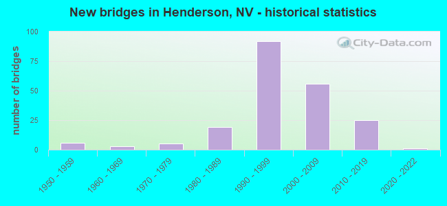
- New bridges - historical statistics
- 61950-1959
- 31960-1969
- 51970-1979
- 191980-1989
- 921990-1999
- 562000-2009
- 252010-2019
- 12020-2022

- Reconstructed bridges - Historical Statistics
- 11980-1989
- 21990-1999


- Bridge Condition - Deck
- 9.8%Very good
- 63.9%Good
- 23.0%Satisfactory
- 3.3%Fair

- Bridge Condition - Superstructure
- 37.7%Very good
- 54.1%Good
- 8.2%Satisfactory

- Bridge Condition - Substructure
- 23.0%Very good
- 68.9%Good
- 8.2%Satisfactory

- Bridge Condition - Channel
- 57.8%Very good
- 25.9%Good
- 15.5%Satisfactory
- 0.9%Fair

- Bridge Condition - Culverts
- 1.8%Very good
- 54.5%Good
- 41.8%Satisfactory
- 1.8%Fair
Find on map >> Show street view
Structure Number: B 603, Location: SOUTHWEST OF HENDERSON (Lat: 36.011294, Lng: -115.108497), Route carried "on" structure: State highway 146, Year Built: 1956, Year Reconstructed: 1998, Status: Open, Structure Length: 1.02m (3.35ft), Average Daily Traffic: 45,000 (year 2017), Truck Traffic: 10%, Average Future Daily Traffic: 93,065 (year 2040), Design Load: HS 20, Features Intersected: DRY WASH
Minimum Vertical Clearance: 30+ m (98+ ft), Kilometerpoint: 9.007, Lanes on structure: 8, Owner: State Highway Agency, Approaching Roadway Width: 45.3m (148.6ft), Skew: 20 degrees, Material/Design: Concrete, Design/Construction: Culvert, Number Of Spans In Main Unit: 3, Length of Maximum Span: 3.0m (9.8ft)
Condition: Channel: Very good, Culverts: Satisfactory, Operating Rating: 58.8 metric tons, Method Used To Determine Operating Rating: Load Factor (LF), Inventory Rating: 35.2 metric tons, Method Used To Determine Inventory Rating: Load Factor (LF), Structural Evaluation: Equal to present minimum criteria, Waterway Adequacy: Equal to present desirable criteria, Approach Roadway Alignment: Equal to present desirable criteria, Designated Inspection Frequency: Every 48 months, Inspection Date: September 2021
Find on map >> Show street view
Structure Number: B 605, Location: West of Henderson (Lat: 36.028586, Lng: -115.053322), Route carried "on" structure: City street 215, Year Built: 1956, Status: Open, Structure Length: 1.95m (6.40ft), Average Daily Traffic: 159,000 (year 2017), Truck Traffic: 15%, Average Future Daily Traffic: 328,831 (year 2040), Design Load: HS 20, Features Intersected: DRY WASH
Minimum Vertical Clearance: 30+ m (98+ ft), Kilometerpoint: 0.000, Lanes on structure: 6, Base Highway Network: Yes, Owner: State Highway Agency, Approaching Roadway Width: 21.9m (71.9ft), Skew: 30 degrees, Material/Design: Concrete, Design/Construction: Culvert, Number Of Spans In Main Unit: 1, Length of Maximum Span: 3.7m (12.1ft)
Condition: Channel: Good, Culverts: Good, Operating Rating: 44.7 metric tons, Method Used To Determine Operating Rating: Load Factor (LF), Inventory Rating: 24.5 metric tons, Method Used To Determine Inventory Rating: Load Factor (LF), Structural Evaluation: Equal to present minimum criteria, Waterway Adequacy: Equal to present minimum criteria, Approach Roadway Alignment: Equal to present desirable criteria, Designated Inspection Frequency: Every 24 months, Inspection Date: Febuary 2021
Find on map >> Show street view
Structure Number: B 613, Location: WEST OF HENDERSON (Lat: 36.028825, Lng: -115.051483), Route carried "on" structure: Interstate 215, Year Built: 1956, Status: Open, Structure Length: 2.35m (7.71ft), Average Daily Traffic: 159,000 (year 2017), Truck Traffic: 15%, Average Future Daily Traffic: 328,831 (year 2040), Design Load: HS 20, Features Intersected: DRY WASH
Minimum Vertical Clearance: 30+ m (98+ ft), Kilometerpoint: 14.688, Lanes on structure: 8, Base Highway Network: Yes, Owner: City or Municipal Highway Agency, Approaching Roadway Width: 12.2m (40.0ft), Skew: 30 degrees, Material/Design: Concrete, Design/Construction: Culvert, Number Of Spans In Main Unit: 5, Length of Maximum Span: 3.0m (9.8ft)
Condition: Channel: Very good, Culverts: Satisfactory, Inventory Rating: 90.5 metric tons, Method Used To Determine Inventory Rating: Load Factor (LF), Structural Evaluation: Equal to present minimum criteria, Waterway Adequacy: Better than present minimum criteria, Approach Roadway Alignment: Equal to present desirable criteria, Designated Inspection Frequency: Every 48 months, Inspection Date: October 2021
Find on map >> Show street view
Structure Number: B 615, Location: HENDERSON (Lat: 36.033867, Lng: -115.011742), Route carried "on" structure: State highway 564, Year Built: 1956, Year Reconstructed: 1988, Status: Open, Structure Length: 0.64m (2.10ft), Average Daily Traffic: 57,000 (year 2017), Truck Traffic: 12%, Average Future Daily Traffic: 117,883 (year 2040), Design Load: HS 20, Features Intersected: DRY WASH
Minimum Vertical Clearance: 30+ m (98+ ft), Kilometerpoint: 18.282, Lanes on structure: 9, Owner: State Highway Agency, Approaching Roadway Width: 30.9m (101.4ft), Skew: 21 degrees, Material/Design: Concrete, Design/Construction: Culvert, Number Of Spans In Main Unit: 2, Length of Maximum Span: 3.6m (11.8ft)
Condition: Channel: Good, Culverts: Satisfactory, Operating Rating: 50.9 metric tons, Method Used To Determine Operating Rating: Load Factor (LF), Inventory Rating: 30.7 metric tons, Method Used To Determine Inventory Rating: Load Factor (LF), Structural Evaluation: Equal to present minimum criteria, Waterway Adequacy: Superior to present desirable criteria, Approach Roadway Alignment: Equal to present desirable criteria, Length Of Structure Improvement: 1.26m (4.13ft), Designated Inspection Frequency: Every 24 months, Inspection Date: October 2021, Bridge Improvement Cost: $220,000, Roadway Improvement Cost: $22,000, Total Project Cost: $330,000
Find on map >> Show street view
Structure Number: B1402, Location: SOUTH OF LAS VEGAS (Lat: 36.019067, Lng: -114.958917), Route carried "on" structure: State highway 582, Year Built: 2002, Status: Open, Structure Length: 2.78m (9.12ft), Average Daily Traffic: 19,000 (year 2017), Truck Traffic: 6%, Average Future Daily Traffic: 39,294 (year 2040), Features Intersected: WHITE ROCK WASH
Minimum Vertical Clearance: 30+ m (98+ ft), Kilometerpoint: 0.000, Lanes on structure: 4, Owner: State Highway Agency, Approaching Roadway Width: 26.5m (86.9ft), Skew: 24 degrees, Material/Design: Concrete, Design/Construction: Culvert, Number Of Spans In Main Unit: 3, Length of Maximum Span: 8.6m (28.2ft), Curb or Sidewalk Widths: Left: 3.1m (10.2ft), Right: 0.0m
Condition: Channel: Very good, Culverts: Satisfactory, Operating Rating: 32.7 metric tons, Method Used To Determine Operating Rating: Field evaluation and documented engineering judgment, Inventory Rating: 19.6 metric tons, Method Used To Determine Inventory Rating: Field evaluation and documented engineering judgment, Structural Evaluation: Meets minimum limits, Waterway Adequacy: Superior to present desirable criteria, Approach Roadway Alignment: Equal to present desirable criteria, Designated Inspection Frequency: Every 24 months, Inspection Date: October 2021
Find on map >> Show street view
Structure Number: B1461, Location: West of Henderson (Lat: 36.049156, Lng: -115.023950), Route carried "on" structure: US 515, Year Built: 1988, Status: Open, Structure Length: 1.62m (5.31ft), Average Daily Traffic: 20,000 (year 2017), Truck Traffic: 3%, Average Future Daily Traffic: 41,362 (year 2040), Design Load: HS 20+Mod, Features Intersected: DRY WASH
Minimum Vertical Clearance: 30+ m (98+ ft), Kilometerpoint: 171.701, Lanes on structure: 6, Base Highway Network: Yes, Owner: State Highway Agency, Approaching Roadway Width: 21.9m (71.9ft), Skew: 35 degrees, Material/Design: Concrete, Design/Construction: Culvert, Number Of Spans In Main Unit: 2, Length of Maximum Span: 4.8m (15.7ft)
Condition: Channel: Very good, Culverts: Satisfactory, Inventory Rating: 61.0 metric tons, Method Used To Determine Inventory Rating: Load Factor (LF), Structural Evaluation: Equal to present minimum criteria, Waterway Adequacy: Superior to present desirable criteria, Approach Roadway Alignment: Equal to present desirable criteria, Designated Inspection Frequency: Every 48 months, Inspection Date: Febuary 2021
Find on map >> Show street view
Structure Number: B1484, Location: NORTH OF HENDERSON (Lat: 36.068717, Lng: -114.958856), Route carried "on" structure: State highway 564, Year Built: 1998, Status: Open, Structure Length: 1.18m (3.87ft), Average Daily Traffic: 18,000 (year 2017), Truck Traffic: 5%, Average Future Daily Traffic: 37,226 (year 2040), Design Load: HS 20+Mod, Features Intersected: WHITE ROCK WASH
Minimum Vertical Clearance: 30+ m (98+ ft), Kilometerpoint: 0.000, Lanes on structure: 6, Base Highway Network: Yes, Owner: State Highway Agency, Approaching Roadway Width: 24.0m (78.7ft), Skew: 15 degrees, Material/Design: Concrete, Design/Construction: Culvert, Number Of Spans In Main Unit: 2, Length of Maximum Span: 5.8m (19.0ft)
Condition: Channel: Very good, Culverts: Good, Operating Rating: 65.3 metric tons, Method Used To Determine Operating Rating: Load Factor (LF), Inventory Rating: 39.2 metric tons, Method Used To Determine Inventory Rating: Load Factor (LF), Structural Evaluation: Better than present minimum criteria, Waterway Adequacy: Equal to present desirable criteria, Approach Roadway Alignment: Equal to present desirable criteria, Designated Inspection Frequency: Every 48 months, Inspection Date: October 2021
Find on map >> Show street view
Structure Number: B1548, Location: HENDERSON (Lat: 36.083703, Lng: -115.036031), Route carried "on" structure: County highway , Year Built: 2004, Status: Open, Structure Length: 2.25m (7.38ft), Average Daily Traffic: 20,000 (year 2017), Truck Traffic: 4%, Average Future Daily Traffic: 34,600 (year 2040), Design Load: HS 20+Mod, Features Intersected: PITTMAN WASH, Facility Carried by Structure: RUSSELL RD
Minimum Vertical Clearance: 30+ m (98+ ft), Kilometerpoint: 0.000, Lanes on structure: 4, Owner: County Highway Agency, Approaching Roadway Width: 21.3m (69.9ft), Skew: 3 degrees, Material/Design: Concrete, Design/Construction: Culvert, Number Of Spans In Main Unit: 2, Length of Maximum Span: 11.0m (36.1ft), Curb or Sidewalk Widths: Left: 0.0m, Right: 1.7m (5.6ft), Curb-To-Curb Width: 29.2m (95.8ft), Out-to-Out Width: 31.7m (104.0ft)
Condition: Channel: Very good, Culverts: Good, Operating Rating: 44.7 metric tons, Method Used To Determine Operating Rating: Load Factor (LF), Inventory Rating: 26.8 metric tons, Method Used To Determine Inventory Rating: Load Factor (LF), Structural Evaluation: Equal to present minimum criteria, Deck Geometry: Superior to present desirable criteria, Waterway Adequacy: Equal to present desirable criteria, Approach Roadway Alignment: Equal to present desirable criteria, Designated Inspection Frequency: Every 24 months, Inspection Date: October 2021
Find on map >> Show street view
Structure Number: B1758, Location: HENDERSON (Lat: 36.048928, Lng: -114.958786), Route carried "on" structure: City street , Year Built: 1983, Status: Open, Structure Length: 1.55m (5.09ft), Average Daily Traffic: 1,200 (year 2017), Truck Traffic: 3%, Average Future Daily Traffic: 2,482 (year 2040), Design Load: HS 20, Features Intersected: WHITE ROCK WASH, Facility Carried by Structure: WARM SPRINGS RD
Minimum Vertical Clearance: 30+ m (98+ ft), Kilometerpoint: 0.000, Lanes on structure: 6, Owner: City or Municipal Highway Agency, Approaching Roadway Width: 27.1m (88.9ft), Skew: 20 degrees, Material/Design: Concrete, Design/Construction: Culvert, Number Of Spans In Main Unit: 4, Length of Maximum Span: 3.7m (12.1ft), Curb or Sidewalk Widths: Left: 1.6m (5.2ft), Right: 1.6m (5.2ft)
Condition: Channel: Very good, Culverts: Satisfactory, Operating Rating: 32.7 metric tons, Method Used To Determine Operating Rating: Load Factor (LF), Inventory Rating: 24.1 metric tons, Method Used To Determine Inventory Rating: Load Factor (LF), Structural Evaluation: Equal to present minimum criteria, Waterway Adequacy: Equal to present desirable criteria, Approach Roadway Alignment: Equal to present desirable criteria, Designated Inspection Frequency: Every 24 months, Inspection Date: October 2021, Deck Structure Type: Concrete Cast-file-Place, Wearing Surface/Protective System: Wearing Surface: Monolithic Concrete
Find on map >> Show street view
Structure Number: B1852, Location: HENDERSON (Lat: 36.023553, Lng: -114.964097), Route carried "on" structure: State highway 582, Year Built: 1988, Status: Open, Structure Length: 1.19m (3.90ft), Average Daily Traffic: 19,000 (year 2017), Truck Traffic: 4%, Average Future Daily Traffic: 39,294 (year 2040), Design Load: HS 20, Features Intersected: DRAIN CHNL
Minimum Vertical Clearance: 30+ m (98+ ft), Kilometerpoint: 0.000, Lanes on structure: 4, Owner: State Highway Agency, Approaching Roadway Width: 24.7m (81.0ft), Skew: 14 degrees, Material/Design: Concrete, Design/Construction: Culvert, Number Of Spans In Main Unit: 2, Length of Maximum Span: 5.5m (18.0ft)
Condition: Channel: Good, Culverts: Good, Operating Rating: 64.6 metric tons, Method Used To Determine Operating Rating: Load Factor (LF), Inventory Rating: 38.8 metric tons, Method Used To Determine Inventory Rating: Load Factor (LF), Structural Evaluation: Better than present minimum criteria, Waterway Adequacy: Superior to present desirable criteria, Approach Roadway Alignment: Equal to present desirable criteria, Designated Inspection Frequency: Every 48 months, Inspection Date: October 2021
Find on map >> Show street view
Structure Number: B1911, Location: HENDERSON (Lat: 35.994175, Lng: -114.935111), Route carried "on" structure: City street , Year Built: 1993, Status: Open, Structure Length: 0.76m (2.49ft), Average Daily Traffic: 633 (year 2017), Truck Traffic: 5%, Average Future Daily Traffic: 1,309 (year 2040), Design Load: HS 20+Mod, Features Intersected: DRY WASH, Facility Carried by Structure: CONESTOGA WY
Minimum Vertical Clearance: 30+ m (98+ ft), Kilometerpoint: 0.000, Lanes on structure: 2, Owner: State Highway Agency, Approaching Roadway Width: 13.6m (44.6ft), Material/Design: Concrete, Design/Construction: Culvert, Number Of Spans In Main Unit: 3, Length of Maximum Span: 2.4m (7.9ft)
Condition: Channel: Satisfactory, Culverts: Good, Operating Rating: 64.3 metric tons, Method Used To Determine Operating Rating: Load Factor (LF), Inventory Rating: 38.5 metric tons, Method Used To Determine Inventory Rating: Load Factor (LF), Structural Evaluation: Better than present minimum criteria, Waterway Adequacy: Equal to present desirable criteria, Approach Roadway Alignment: Equal to present desirable criteria, Designated Inspection Frequency: Every 48 months, Inspection Date: October 2021
Find on map >> Show street view
Structure Number: B1912, Location: HENDERSON (Lat: 35.995844, Lng: -114.935503), Route carried "on" structure: US 515, Year Built: 1993, Status: Open, Structure Length: 0.85m (2.79ft), Average Daily Traffic: 40,420 (year 2017), Truck Traffic: 7%, Average Future Daily Traffic: 83,593 (year 2040), Design Load: HS 20+Mod, Features Intersected: DRY WASH
Minimum Vertical Clearance: 30+ m (98+ ft), Kilometerpoint: 95.754, Lanes on structure: 9, Base Highway Network: Yes, Owner: State Highway Agency, Approaching Roadway Width: 51.8m (169.9ft), Skew: 32 degrees, Material/Design: Concrete, Design/Construction: Culvert, Number Of Spans In Main Unit: 3, Length of Maximum Span: 2.7m (8.9ft)
Condition: Channel: Good, Culverts: Satisfactory, Inventory Rating: 85.7 metric tons, Method Used To Determine Inventory Rating: Load Factor (LF), Structural Evaluation: Equal to present minimum criteria, Waterway Adequacy: Equal to present desirable criteria, Approach Roadway Alignment: Equal to present desirable criteria, Designated Inspection Frequency: Every 48 months, Inspection Date: October 2021
Find on map >> Show street view
Structure Number: B1913, Location: HENDERSON (Lat: 35.996986, Lng: -114.935914), Route carried "on" structure: Ramp Other road 515, Year Built: 1993, Status: Open, Structure Length: 0.79m (2.59ft), Average Daily Traffic: 9,400 (year 2017), Truck Traffic: 8%, Average Future Daily Traffic: 19,440 (year 2040), Design Load: HS 20+Mod, Features Intersected: DRY WASH, Facility Carried by Structure: RMP WAGONWHEEL-95N
Minimum Vertical Clearance: 30+ m (98+ ft), Kilometerpoint: 0.000, Lanes on structure: 1, Owner: State Highway Agency, Approaching Roadway Width: 9.1m (29.9ft), Material/Design: Concrete, Design/Construction: Culvert, Number Of Spans In Main Unit: 3, Length of Maximum Span: 2.4m (7.9ft)
Condition: Channel: Satisfactory, Culverts: Good, Structural Evaluation: Better than present minimum criteria, Approach Roadway Alignment: Equal to present desirable criteria, Designated Inspection Frequency: Every 48 months, Inspection Date: October 2021
Find on map >> Show street view
Structure Number: B1915, Location: HENDERSON (Lat: 36.002167, Lng: -114.940722), Route carried "on" structure: Ramp Other road 515, Year Built: 1992, Status: Open, Structure Length: 2.78m (9.12ft), Average Daily Traffic: 2,500 (year 2017), Truck Traffic: 7%, Average Future Daily Traffic: 5,170 (year 2040), Design Load: HS 20+Mod, Features Intersected: DRY WASH, Facility Carried by Structure: RMP BOULDER-WWHEEL
Minimum Vertical Clearance: 30+ m (98+ ft), Kilometerpoint: 0.000, Lanes on structure: 1, Owner: State Highway Agency, Approaching Roadway Width: 7.9m (25.9ft), Skew: 4 degrees, Material/Design: Concrete, Design/Construction: Culvert, Number Of Spans In Main Unit: 5, Length of Maximum Span: 5.3m (17.4ft)
Condition: Channel: Good, Culverts: Good, Operating Rating: 64.6 metric tons, Method Used To Determine Operating Rating: Load Factor (LF), Inventory Rating: 38.8 metric tons, Method Used To Determine Inventory Rating: Load Factor (LF), Structural Evaluation: Better than present minimum criteria, Waterway Adequacy: Equal to present desirable criteria, Approach Roadway Alignment: Equal to present desirable criteria, Designated Inspection Frequency: Every 48 months, Inspection Date: October 2021
Find on map >> Show street view
Structure Number: B1916, Location: HENDERSON (Lat: 35.999561, Lng: -114.945464), Route carried "on" structure: US 515, Year Built: 1993, Status: Open, Structure Length: 0.79m (2.59ft), Average Daily Traffic: 62,000 (year 2017), Truck Traffic: 7%, Average Future Daily Traffic: 79,000 (year 2040), Design Load: HS 20+Mod, Features Intersected: DRY WASH
Minimum Vertical Clearance: 30+ m (98+ ft), Kilometerpoint: 96.730, Lanes on structure: 6, Base Highway Network: Yes, Owner: State Highway Agency, Approaching Roadway Width: 35.8m (117.5ft), Skew: 30 degrees, Material/Design: Concrete, Design/Construction: Culvert, Number Of Spans In Main Unit: 3, Length of Maximum Span: 2.4m (7.9ft)
Condition: Channel: Good, Culverts: Good, Structural Evaluation: Better than present minimum criteria, Waterway Adequacy: Equal to present desirable criteria, Approach Roadway Alignment: Equal to present desirable criteria, Length Of Structure Improvement: 1.44m (4.72ft), Designated Inspection Frequency: Every 48 months, Inspection Date: October 2021, Bridge Improvement Cost: $210,000, Roadway Improvement Cost: $21,000, Total Project Cost: $315,000
Find on map >> Show street view
Structure Number: B1917, Location: HENDERSON (Lat: 35.999947, Lng: -114.959389), Route carried "on" structure: US 515, Year Built: 1993, Status: Open, Structure Length: 0.64m (2.10ft), Average Daily Traffic: 48,000 (year 2017), Truck Traffic: 7%, Average Future Daily Traffic: 99,270 (year 2040), Design Load: HS 20+Mod, Features Intersected: DRY WASH
Minimum Vertical Clearance: 30+ m (98+ ft), Kilometerpoint: 97.988, Lanes on structure: 9, Base Highway Network: Yes, Owner: State Highway Agency, Approaching Roadway Width: 52.4m (171.9ft), Skew: 30 degrees, Material/Design: Concrete, Design/Construction: Culvert, Number Of Spans In Main Unit: 2, Length of Maximum Span: 3.0m (9.8ft)
Condition: Channel: Satisfactory, Culverts: Good, Structural Evaluation: Better than present minimum criteria, Waterway Adequacy: Equal to present desirable criteria, Approach Roadway Alignment: Equal to present desirable criteria, Length Of Structure Improvement: 1.26m (4.13ft), Designated Inspection Frequency: Every 48 months, Inspection Date: October 2021, Bridge Improvement Cost: $541,000, Roadway Improvement Cost: $54,000, Total Project Cost: $812,000
Find on map >> Show street view
Structure Number: B1918, Location: HENDERSON (Lat: 35.998444, Lng: -114.963233), Route carried "on" structure: City street 567, Year Built: 1993, Status: Open, Structure Length: 1.27m (4.17ft), Average Daily Traffic: 11,000 (year 2017), Truck Traffic: 4%, Average Future Daily Traffic: 22,749 (year 2040), Design Load: HS 20+Mod, Features Intersected: DRY WASH
Minimum Vertical Clearance: 30+ m (98+ ft), Kilometerpoint: 0.000, Lanes on structure: 7, Owner: State Highway Agency, Approaching Roadway Width: 26.8m (87.9ft), Skew: 20 degrees, Material/Design: Concrete, Design/Construction: Culvert, Number Of Spans In Main Unit: 4, Length of Maximum Span: 3.0m (9.8ft), Curb or Sidewalk Widths: Left: 1.7m (5.6ft), Right: 1.7m (5.6ft)
Condition: Channel: Satisfactory, Culverts: Good, Structural Evaluation: Better than present minimum criteria, Waterway Adequacy: Equal to present desirable criteria, Approach Roadway Alignment: Equal to present desirable criteria, Length Of Structure Improvement: 2.01m (6.59ft), Designated Inspection Frequency: Every 48 months, Inspection Date: October 2021, Bridge Improvement Cost: $443,000, Roadway Improvement Cost: $44,000, Total Project Cost: $664,000
Find on map >> Show street view
Structure Number: B1923, Location: HENDERSON (Lat: 36.032122, Lng: -115.012839), Route carried "on" structure: State highway 564, Year Built: 1993, Status: Open, Structure Length: 1.01m (3.31ft), Average Daily Traffic: 100,000 (year 2017), Truck Traffic: 7%, Average Future Daily Traffic: 163,000 (year 2040), Design Load: HS 20+Mod, Features Intersected: DRY WASH
Minimum Vertical Clearance: 30+ m (98+ ft), Kilometerpoint: 0.000, Lanes on structure: 7, Owner: State Highway Agency, Approaching Roadway Width: 43.3m (142.1ft), Skew: 33 degrees, Material/Design: Concrete, Design/Construction: Culvert, Number Of Spans In Main Unit: 3, Length of Maximum Span: 3.0m (9.8ft)
Condition: Channel: Good, Culverts: Satisfactory, Structural Evaluation: Equal to present minimum criteria, Waterway Adequacy: Equal to present desirable criteria, Approach Roadway Alignment: Equal to present desirable criteria, Length Of Structure Improvement: 1.68m (5.51ft), Designated Inspection Frequency: Every 48 months, Inspection Date: October 2021, Bridge Improvement Cost: $597,000, Roadway Improvement Cost: $60,000, Total Project Cost: $896,000
Find on map >> Show street view
Structure Number: B1932, Location: HENDERSON (Lat: 36.063678, Lng: -115.049022), Route carried "on" structure: State highway 562, Year Built: 1987, Status: Open, Structure Length: 2.07m (6.79ft), Average Daily Traffic: 29,000 (year 2017), Truck Traffic: 8%, Average Future Daily Traffic: 59,975 (year 2040), Design Load: HS 20, Features Intersected: PITTMAN WASH
Minimum Vertical Clearance: 30+ m (98+ ft), Kilometerpoint: 0.000, Lanes on structure: 7, Owner: City or Municipal Highway Agency, Approaching Roadway Width: 24.5m (80.4ft), Skew: 20 degrees, Material/Design: Concrete continuous, Design/Construction: Slab, Number Of Spans In Main Unit: 2, Length of Maximum Span: 9.8m (32.2ft), Curb or Sidewalk Widths: Left: 1.4m (4.6ft), Right: 1.4m (4.6ft), Curb-To-Curb Width: 27.3m (89.6ft), Out-to-Out Width: 30.5m (100.1ft)
Condition: Deck: Good, Superstructure: Good, Substructure: Good, Channel: Good, Operating Rating: 79.3 metric tons, Method Used To Determine Operating Rating: Load Factor (LF), Inventory Rating: 47.3 metric tons, Method Used To Determine Inventory Rating: Load Factor (LF), Structural Evaluation: Better than present minimum criteria, Deck Geometry: Somewhat better than minimum adequacy, Waterway Adequacy: Equal to present desirable criteria, Approach Roadway Alignment: Equal to present desirable criteria, Length Of Structure Improvement: 2.84m (9.32ft), Designated Inspection Frequency: Every 48 months, Inspection Date: October 2021, Bridge Improvement Cost: $710,000, Roadway Improvement Cost: $71,000, Total Project Cost: $1,064,000, Deck Structure Type: Concrete Cast-file-Place, Wearing Surface/Protective System: Wearing Surface: Bituminous
Find on map >> Show street view
Structure Number: B1933, Location: HENDERSON (Lat: 36.056244, Lng: -115.049042), Route carried "on" structure: City street 568, Year Built: 1988, Status: Open, Structure Length: 1.95m (6.40ft), Average Daily Traffic: 20,100 (year 2017), Truck Traffic: 4%, Average Future Daily Traffic: 41,569 (year 2040), Design Load: HS 20+Mod, Features Intersected: PITTMAN WASH, Facility Carried by Structure: WARM SPRINGS RD
Minimum Vertical Clearance: 30+ m (98+ ft), Kilometerpoint: 0.000, Lanes on structure: 7, Owner: City or Municipal Highway Agency, Approaching Roadway Width: 25.3m (83.0ft), Skew: 20 degrees, Material/Design: Concrete, Design/Construction: Box Beam or Girders - Multiple, Number Of Spans In Main Unit: 1, Length of Maximum Span: 18.9m (62.0ft), Curb or Sidewalk Widths: Left: 1.5m (4.9ft), Right: 1.5m (4.9ft), Curb-To-Curb Width: 26.6m (87.3ft), Out-to-Out Width: 30.5m (100.1ft)
Condition: Deck: Fair, Superstructure: Satisfactory, Substructure: Good, Channel: Very good, Inventory Rating: 59.0 metric tons, Method Used To Determine Inventory Rating: Load Factor (LF), Structural Evaluation: Equal to present minimum criteria, Deck Geometry: Meets minimum limits, Waterway Adequacy: Equal to present desirable criteria, Approach Roadway Alignment: Equal to present desirable criteria, Designated Inspection Frequency: Every 48 months, Inspection Date: October 2021, Deck Structure Type: Concrete Cast-file-Place, Wearing Surface/Protective System: Wearing Surface: Monolithic Concrete
Find on map >> Show street view
Structure Number: B1934, Location: HENDERSON (Lat: 36.077497, Lng: -115.045778), Route carried "on" structure: City street , Year Built: 1989, Status: Open, Structure Length: 3.78m (12.40ft), Average Daily Traffic: 19,000 (year 2017), Truck Traffic: 7%, Average Future Daily Traffic: 21,000 (year 2040), Design Load: HS 20, Features Intersected: PITTMAN WASH, Facility Carried by Structure: STEPHANIE ST
Minimum Vertical Clearance: 30+ m (98+ ft), Kilometerpoint: 0.000, Lanes on structure: 4, Owner: City or Municipal Highway Agency, Approaching Roadway Width: 22.6m (74.1ft), Skew: 25 degrees, Material/Design: Concrete continuous, Design/Construction: Slab, Number Of Spans In Main Unit: 3, Length of Maximum Span: 14.9m (48.9ft), Curb or Sidewalk Widths: Left: 1.3m (4.3ft), Right: 1.3m (4.3ft), Curb-To-Curb Width: 26.5m (86.9ft), Out-to-Out Width: 30.5m (100.1ft)
Condition: Deck: Satisfactory, Superstructure: Satisfactory, Substructure: Satisfactory, Channel: Good, Operating Rating: 72.7 metric tons, Method Used To Determine Operating Rating: Load Factor (LF), Inventory Rating: 43.7 metric tons, Method Used To Determine Inventory Rating: Load Factor (LF), Structural Evaluation: Equal to present minimum criteria, Deck Geometry: Superior to present desirable criteria, Waterway Adequacy: Equal to present desirable criteria, Approach Roadway Alignment: Equal to present desirable criteria, Designated Inspection Frequency: Every 48 months, Inspection Date: October 2021, Deck Structure Type: Concrete Cast-file-Place, Wearing Surface/Protective System: Wearing Surface: Monolithic Concrete
Find on map >> Show street view
Structure Number: B1965, Location: HENDERSON (Lat: 36.023669, Lng: -115.115078), Route carried "on" structure: Interstate 215, Year Built: 1999, Status: Open, Structure Length: 2.66m (8.73ft), Average Daily Traffic: 121,000 (year 2017), Average Future Daily Traffic: 250,242 (year 2040), Design Load: HS 20+Mod, Features Intersected: DRY CHANNEL
Minimum Vertical Clearance: 30+ m (98+ ft), Kilometerpoint: 0.000, Lanes on structure: 8, Base Highway Network: Yes, Owner: County Highway Agency, Approaching Roadway Width: 44.0m (144.4ft), Skew: 30 degrees, Material/Design: Concrete, Design/Construction: Culvert, Number Of Spans In Main Unit: 7, Length of Maximum Span: 3.6m (11.8ft)
Condition: Channel: Good, Culverts: Good, Operating Rating: 56.1 metric tons, Method Used To Determine Operating Rating: Load Factor (LF), Inventory Rating: 33.6 metric tons, Method Used To Determine Inventory Rating: Load Factor (LF), Structural Evaluation: Better than present minimum criteria, Waterway Adequacy: Equal to present desirable criteria, Approach Roadway Alignment: Equal to present desirable criteria, Designated Inspection Frequency: Every 48 months, Inspection Date: October 2021
Find on map >> Show street view
Structure Number: B2044, Location: HENDERSON (Lat: 36.003681, Lng: -114.962953), Route carried "on" structure: City street , Year Built: 1987, Status: Open, Structure Length: 1.28m (4.20ft), Average Daily Traffic: 1,606 (year 2017), Truck Traffic: 5%, Average Future Daily Traffic: 2,500 (year 2040), Features Intersected: DRAIN CHNL, Facility Carried by Structure: VERMILLION PL
Minimum Vertical Clearance: 30+ m (98+ ft), Kilometerpoint: 0.000, Lanes on structure: 2, Owner: City or Municipal Highway Agency, Approaching Roadway Width: 14.9m (48.9ft), Material/Design: Concrete, Design/Construction: Culvert, Number Of Spans In Main Unit: 4, Length of Maximum Span: 3.0m (9.8ft), Curb or Sidewalk Widths: Left: 1.7m (5.6ft), Right: 1.7m (5.6ft)
Condition: Channel: Very good, Culverts: Satisfactory, Operating Rating: 32.7 metric tons, Method Used To Determine Operating Rating: Field evaluation and documented engineering judgment, Inventory Rating: 19.6 metric tons, Method Used To Determine Inventory Rating: Field evaluation and documented engineering judgment, Structural Evaluation: Somewhat better than minimum adequacy, Waterway Adequacy: Better than present minimum criteria, Approach Roadway Alignment: Equal to present desirable criteria, Length Of Structure Improvement: 2.01m (6.59ft), Designated Inspection Frequency: Every 24 months, Inspection Date: October 2021, Bridge Improvement Cost: $246,000, Roadway Improvement Cost: $25,000, Total Project Cost: $369,000
Find on map >> Show street view
Structure Number: B2045, Location: HENDERSON (Lat: 36.005567, Lng: -114.963194), Route carried "on" structure: City street , Year Built: 1987, Status: Open, Structure Length: 0.67m (2.20ft), Average Daily Traffic: 15,000 (year 2017), Truck Traffic: 10%, Average Future Daily Traffic: 18,000 (year 2040), Design Load: HS 20, Features Intersected: DRAIN CHNL, Facility Carried by Structure: COLLEGE DR
Minimum Vertical Clearance: 30+ m (98+ ft), Kilometerpoint: 0.000, Lanes on structure: 6, Owner: City or Municipal Highway Agency, Approaching Roadway Width: 26.8m (87.9ft), Skew: 3 degrees, Material/Design: Concrete, Design/Construction: Culvert, Number Of Spans In Main Unit: 2, Length of Maximum Span: 3.0m (9.8ft)
Condition: Channel: Very good, Culverts: Satisfactory, Operating Rating: 90.5 metric tons, Method Used To Determine Operating Rating: Field evaluation and documented engineering judgment, Inventory Rating: 76.7 metric tons, Method Used To Determine Inventory Rating: Field evaluation and documented engineering judgment, Structural Evaluation: Equal to present minimum criteria, Waterway Adequacy: Equal to present minimum criteria, Approach Roadway Alignment: Equal to present desirable criteria, Designated Inspection Frequency: Every 48 months, Inspection Date: October 2019
Find on map >> Show street view
Structure Number: B2096, Location: HENDERSON (Lat: 36.043333, Lng: -115.081667), Route carried "on" structure: City street , Year Built: 1990, Status: Open, Structure Length: 3.68m (12.07ft), Average Daily Traffic: 21,500 (year 2017), Truck Traffic: 3%, Average Future Daily Traffic: 44,465 (year 2040), Design Load: HS 20+Mod, Features Intersected: PITTMAN WASH, Facility Carried by Structure: GREEN VALLEY PW
Minimum Vertical Clearance: 30+ m (98+ ft), Kilometerpoint: 0.000, Lanes on structure: 7, Owner: City or Municipal Highway Agency, Approaching Roadway Width: 25.0m (82.0ft), Skew: 20 degrees, Material/Design: Concrete continuous, Design/Construction: Slab, Number Of Spans In Main Unit: 4, Length of Maximum Span: 10.4m (34.1ft), Curb or Sidewalk Widths: Left: 1.3m (4.3ft), Right: 1.3m (4.3ft), Curb-To-Curb Width: 26.5m (86.9ft), Out-to-Out Width: 30.5m (100.1ft)
Condition: Deck: Good, Superstructure: Good, Substructure: Good, Channel: Satisfactory, Operating Rating: 81.6 metric tons, Method Used To Determine Operating Rating: Load Factor (LF), Inventory Rating: 49.0 metric tons, Method Used To Determine Inventory Rating: Load Factor (LF), Structural Evaluation: Better than present minimum criteria, Deck Geometry: Meets minimum limits, Waterway Adequacy: Equal to present desirable criteria, Approach Roadway Alignment: Equal to present desirable criteria, Length Of Structure Improvement: 4.60m (15.09ft), Designated Inspection Frequency: Every 48 months, Inspection Date: October 2021, Bridge Improvement Cost: $1,151,000, Roadway Improvement Cost: $115,000, Total Project Cost: $1,727,000, Deck Structure Type: Concrete Cast-file-Place, Wearing Surface/Protective System: Wearing Surface: Bituminous
Find on map >> Show street view
Structure Number: B2097, Location: HENDERSON (Lat: 36.039933, Lng: -115.100264), Route carried "on" structure: City street , Year Built: 1992, Status: Open, Structure Length: 3.51m (11.52ft), Average Daily Traffic: 27,000 (year 2017), Truck Traffic: 3%, Average Future Daily Traffic: 55,839 (year 2040), Design Load: HS 20+Mod, Features Intersected: PITTMAN WASH, Facility Carried by Structure: PECOS ROAD
Minimum Vertical Clearance: 30+ m (98+ ft), Kilometerpoint: 0.000, Lanes on structure: 4, Owner: City or Municipal Highway Agency, Approaching Roadway Width: 26.5m (86.9ft), Skew: 20 degrees, Material/Design: Concrete continuous, Design/Construction: Slab, Number Of Spans In Main Unit: 4, Length of Maximum Span: 9.4m (30.8ft), Curb or Sidewalk Widths: Left: 1.5m (4.9ft), Right: 1.5m (4.9ft), Curb-To-Curb Width: 26.2m (86.0ft), Out-to-Out Width: 30.5m (100.1ft)
Condition: Deck: Good, Superstructure: Good, Substructure: Good, Channel: Good, Operating Rating: 57.1 metric tons, Method Used To Determine Operating Rating: Load Factor (LF), Inventory Rating: 34.3 metric tons, Method Used To Determine Inventory Rating: Load Factor (LF), Structural Evaluation: Better than present minimum criteria, Deck Geometry: Superior to present desirable criteria, Waterway Adequacy: Equal to present desirable criteria, Approach Roadway Alignment: Equal to present desirable criteria, Designated Inspection Frequency: Every 48 months, Inspection Date: October 2021, Deck Structure Type: Concrete Cast-file-Place, Wearing Surface/Protective System: Wearing Surface: Bituminous
Find on map >> Show street view
Structure Number: B2098, Location: WEST HENDERSON (Lat: 36.034783, Lng: -115.109247), Route carried "on" structure: City street , Year Built: 1985, Status: Open, Structure Length: 1.92m (6.30ft), Average Daily Traffic: 10,800 (year 2017), Truck Traffic: 7%, Average Future Daily Traffic: 27,500 (year 2040), Design Load: HS 20+Mod, Features Intersected: PITMAN WASH, Facility Carried by Structure: WIGWAM PARKWAY
Minimum Vertical Clearance: 30+ m (98+ ft), Kilometerpoint: 0.000, Lanes on structure: 4, Owner: City or Municipal Highway Agency, Approaching Roadway Width: 20.1m (65.9ft), Skew: 20 degrees, Material/Design: Concrete, Design/Construction: Culvert, Number Of Spans In Main Unit: 6, Length of Maximum Span: 3.0m (9.8ft), Curb or Sidewalk Widths: Left: 1.5m (4.9ft), Right: 1.5m (4.9ft)
Condition: Channel: Satisfactory, Culverts: Satisfactory, Operating Rating: 34.1 metric tons, Method Used To Determine Operating Rating: Load Factor (LF), Inventory Rating: 20.4 metric tons, Method Used To Determine Inventory Rating: Load Factor (LF), Structural Evaluation: Somewhat better than minimum adequacy, Waterway Adequacy: Equal to present desirable criteria, Approach Roadway Alignment: Equal to present desirable criteria, Length Of Structure Improvement: 2.65m (8.69ft), Designated Inspection Frequency: Every 24 months, Inspection Date: October 2021, Bridge Improvement Cost: $437,000, Roadway Improvement Cost: $44,000, Total Project Cost: $656,000
Find on map >> Show street view
Structure Number: B2121, Location: HENDERSON (Lat: 36.029631, Lng: -115.043069), Route carried "on" structure: Interstate 215, Year Built: 1999, Status: Open, Structure Length: 0.78m (2.56ft), Average Daily Traffic: 140,000 (year 2017), Average Future Daily Traffic: 289,536 (year 2040), Features Intersected: DRY WASH
Minimum Vertical Clearance: 30+ m (98+ ft), Kilometerpoint: 0.000, Lanes on structure: 8, Base Highway Network: Yes, Owner: State Highway Agency, Approaching Roadway Width: 56.0m (183.7ft), Skew: 39 degrees, Material/Design: Concrete, Design/Construction: Culvert, Number Of Spans In Main Unit: 2, Length of Maximum Span: 3.6m (11.8ft)
Condition: Channel: Very good, Culverts: Good, Operating Rating: 32.7 metric tons, Method Used To Determine Operating Rating: Field evaluation and documented engineering judgment, Inventory Rating: 19.6 metric tons, Method Used To Determine Inventory Rating: Field evaluation and documented engineering judgment, Structural Evaluation: Meets minimum limits, Waterway Adequacy: Equal to present desirable criteria, Approach Roadway Alignment: Equal to present desirable criteria, Designated Inspection Frequency: Every 24 months, Other Special Inspection Frequency: Every 24 months, Inspection Date: October 2021, Other Special Inspection Date: Febuary 2021
Find on map >> Show street view
Structure Number: B2122, Location: HENDERSON (Lat: 36.027722, Lng: -115.056144), Route carried "on" structure: City street , Year Built: 1999, Status: Open, Structure Length: 0.75m (2.46ft), Average Daily Traffic: 5,900 (year 2017), Average Future Daily Traffic: 12,202 (year 2040), Design Load: HS 20+Mod, Features Intersected: CHANNEL, Facility Carried by Structure: ARROYO GRANDE
Minimum Vertical Clearance: 30+ m (98+ ft), Kilometerpoint: 0.000, Lanes on structure: 4, Owner: City or Municipal Highway Agency, Approaching Roadway Width: 21.2m (69.6ft), Skew: 21 degrees, Material/Design: Concrete, Design/Construction: Culvert, Number Of Spans In Main Unit: 2, Length of Maximum Span: 3.6m (11.8ft), Curb or Sidewalk Widths: Left: 1.7m (5.6ft), Right: 1.7m (5.6ft)
Condition: Channel: Very good, Culverts: Good, Operating Rating: 56.7 metric tons, Method Used To Determine Operating Rating: Load Factor (LF), Inventory Rating: 33.9 metric tons, Method Used To Determine Inventory Rating: Load Factor (LF), Structural Evaluation: Better than present minimum criteria, Waterway Adequacy: Equal to present desirable criteria, Approach Roadway Alignment: Equal to present desirable criteria, Designated Inspection Frequency: Every 48 months, Inspection Date: October 2021
Find on map >> Show street view
Structure Number: B2123, Location: HENDERSON (Lat: 36.026731, Lng: -115.062569), Route carried "on" structure: City street , Year Built: 1999, Status: Open, Structure Length: 0.75m (2.46ft), Average Daily Traffic: 10,000 (year 2017), Average Future Daily Traffic: 20,681 (year 2040), Design Load: HS 20+Mod, Features Intersected: CHANNEL, Facility Carried by Structure: VALLE VERDE
Minimum Vertical Clearance: 30+ m (98+ ft), Kilometerpoint: 0.000, Lanes on structure: 6, Owner: City or Municipal Highway Agency, Approaching Roadway Width: 38.0m (124.7ft), Skew: 20 degrees, Material/Design: Concrete, Design/Construction: Culvert, Number Of Spans In Main Unit: 2, Length of Maximum Span: 3.6m (11.8ft), Curb or Sidewalk Widths: Left: 1.6m (5.2ft), Right: 1.6m (5.2ft)
Condition: Channel: Very good, Culverts: Good, Operating Rating: 61.5 metric tons, Method Used To Determine Operating Rating: Load Factor (LF), Inventory Rating: 36.8 metric tons, Method Used To Determine Inventory Rating: Load Factor (LF), Structural Evaluation: Better than present minimum criteria, Waterway Adequacy: Equal to present desirable criteria, Approach Roadway Alignment: Equal to present desirable criteria, Designated Inspection Frequency: Every 48 months, Inspection Date: October 2021
Find on map >> Show street view
Structure Number: B2124, Location: HENDERSON (Lat: 36.023464, Lng: -115.092269), Route carried "on" structure: Interstate 215, Year Built: 1999, Status: Open, Structure Length: 1.06m (3.48ft), Average Daily Traffic: 165,000 (year 2017), Average Future Daily Traffic: 341,239 (year 2040), Design Load: HS 20+Mod, Features Intersected: DRY CHANNEL
Minimum Vertical Clearance: 30+ m (98+ ft), Kilometerpoint: 0.000, Lanes on structure: 7, Base Highway Network: Yes, Owner: County Highway Agency, Approaching Roadway Width: 38.0m (124.7ft), Skew: 30 degrees, Material/Design: Concrete, Design/Construction: Culvert, Number Of Spans In Main Unit: 3, Length of Maximum Span: 3.0m (9.8ft)
Condition: Channel: Very good, Culverts: Good, Operating Rating: 84.9 metric tons, Method Used To Determine Operating Rating: Load Factor (LF), Inventory Rating: 50.9 metric tons, Method Used To Determine Inventory Rating: Load Factor (LF), Structural Evaluation: Better than present minimum criteria, Waterway Adequacy: Equal to present desirable criteria, Approach Roadway Alignment: Equal to present desirable criteria, Designated Inspection Frequency: Every 48 months, Inspection Date: October 2021
Find on map >> Show street view
Structure Number: B2126, Location: HENDERSON (Lat: 36.026883, Lng: -115.118322), Route carried "on" structure: City street , Year Built: 1998, Status: Open, Structure Length: 2.90m (9.51ft), Average Daily Traffic: 32,000 (year 2017), Average Future Daily Traffic: 66,180 (year 2040), Design Load: HS 20+Mod, Features Intersected: DRY WASH, Facility Carried by Structure: EASTERN AVE.
Minimum Vertical Clearance: 30+ m (98+ ft), Kilometerpoint: 0.000, Lanes on structure: 6, Owner: County Highway Agency, Approaching Roadway Width: 25.8m (84.6ft), Skew: 24 degrees, Material/Design: Concrete, Design/Construction: Culvert, Number Of Spans In Main Unit: 8, Length of Maximum Span: 3.5m (11.5ft), Curb or Sidewalk Widths: Left: 1.7m (5.6ft), Right: 1.7m (5.6ft)
Condition: Channel: Satisfactory, Culverts: Satisfactory, Operating Rating: 82.7 metric tons, Method Used To Determine Operating Rating: Load Factor (LF), Inventory Rating: 49.6 metric tons, Method Used To Determine Inventory Rating: Load Factor (LF), Structural Evaluation: Equal to present minimum criteria, Waterway Adequacy: Equal to present desirable criteria, Approach Roadway Alignment: Equal to present desirable criteria, Designated Inspection Frequency: Every 48 months, Inspection Date: October 2021
Find on map >> Show street view
Structure Number: B2155, Location: HENDERSON (Lat: 36.046178, Lng: -115.055331), Route carried "on" structure: City street , Year Built: 1994, Status: Open, Structure Length: 1.83m (6.00ft), Average Daily Traffic: 12,000 (year 2017), Truck Traffic: 3%, Average Future Daily Traffic: 24,817 (year 2040), Design Load: HS 20+Mod, Features Intersected: PITTMAN WASH, Facility Carried by Structure: ARROYO GRANDE BLVD
Minimum Vertical Clearance: 30+ m (98+ ft), Kilometerpoint: 0.000, Lanes on structure: 4, Owner: City or Municipal Highway Agency, Approaching Roadway Width: 21.0m (68.9ft), Material/Design: Concrete, Design/Construction: Tee Beam, Number Of Spans In Main Unit: 1, Length of Maximum Span: 18.3m (60.0ft), Curb or Sidewalk Widths: Left: 1.7m (5.6ft), Right: 1.7m (5.6ft), Curb-To-Curb Width: 21.0m (68.9ft), Out-to-Out Width: 24.4m (80.1ft)
Condition: Deck: Very good, Superstructure: Good, Substructure: Satisfactory, Channel: Good, Operating Rating: 84.2 metric tons, Method Used To Determine Operating Rating: Load Factor (LF), Inventory Rating: 50.6 metric tons, Method Used To Determine Inventory Rating: Load Factor (LF), Structural Evaluation: Equal to present minimum criteria, Deck Geometry: Superior to present desirable criteria, Waterway Adequacy: Equal to present desirable criteria, Approach Roadway Alignment: Equal to present desirable criteria, Designated Inspection Frequency: Every 24 months, Inspection Date: November 2021, Deck Structure Type: Concrete Cast-file-Place, Wearing Surface/Protective System: Wearing Surface: Monolithic Concrete
Find on map >> Show street view
Structure Number: B2156, Location: HENDERSON (Lat: 36.042617, Lng: -115.068564), Route carried "on" structure: City street , Year Built: 1992, Status: Open, Structure Length: 2.80m (9.19ft), Average Daily Traffic: 10,200 (year 2017), Truck Traffic: 3%, Average Future Daily Traffic: 21,095 (year 2040), Design Load: HS 20+Mod, Features Intersected: PITTMAN WASH, Facility Carried by Structure: VALLE VERDE DRIVE
Minimum Vertical Clearance: 30+ m (98+ ft), Kilometerpoint: 0.000, Lanes on structure: 4, Owner: City or Municipal Highway Agency, Approaching Roadway Width: 20.4m (66.9ft), Material/Design: Concrete continuous, Design/Construction: Tee Beam, Number Of Spans In Main Unit: 2, Length of Maximum Span: 13.7m (44.9ft), Curb or Sidewalk Widths: Left: 1.6m (5.2ft), Right: 1.6m (5.2ft), Curb-To-Curb Width: 20.4m (66.9ft), Out-to-Out Width: 24.4m (80.1ft)
Condition: Deck: Satisfactory, Superstructure: Good, Substructure: Very good, Channel: Good, Operating Rating: 45.0 metric tons, Method Used To Determine Operating Rating: Load Factor (LF), Inventory Rating: 27.0 metric tons, Method Used To Determine Inventory Rating: Load Factor (LF), Structural Evaluation: Equal to present minimum criteria, Deck Geometry: Superior to present desirable criteria, Waterway Adequacy: Equal to present desirable criteria, Approach Roadway Alignment: Equal to present desirable criteria, Designated Inspection Frequency: Every 24 months, Inspection Date: November 2021, Deck Structure Type: Concrete Cast-file-Place, Wearing Surface/Protective System: Wearing Surface: Monolithic Concrete
Find on map >> Show street view
Structure Number: B2162, Location: IONE RD INTX; HENDRSN (Lat: 36.010097, Lng: -115.117597), Route carried "on" structure: City street , Year Built: 1995, Status: Open, Structure Length: 3.02m (9.91ft), Average Daily Traffic: 52,000 (year 2017), Truck Traffic: 2%, Average Future Daily Traffic: 107,542 (year 2040), Design Load: HS 20+Mod, Features Intersected: DRAINAGE CHANNEL B, Facility Carried by Structure: EASTERN AV
Minimum Vertical Clearance: 30+ m (98+ ft), Kilometerpoint: 0.000, Lanes on structure: 9, Owner: City or Municipal Highway Agency, Approaching Roadway Width: 33.5m (109.9ft), Skew: 26 degrees, Material/Design: Concrete, Design/Construction: Culvert, Number Of Spans In Main Unit: 4, Length of Maximum Span: 7.4m (24.3ft)
Condition: Channel: Very good, Culverts: Satisfactory, Structural Evaluation: Equal to present minimum criteria, Waterway Adequacy: Equal to present desirable criteria, Approach Roadway Alignment: Equal to present desirable criteria, Designated Inspection Frequency: Every 48 months, Inspection Date: October 2020
Find on map >> Show street view
Structure Number: B2163, Location: HENDERSON (Lat: 36.006006, Lng: -115.081506), Route carried "on" structure: City street , Year Built: 1995, Status: Open, Structure Length: 4.57m (14.99ft), Average Daily Traffic: 21,000 (year 2017), Truck Traffic: 2%, Average Future Daily Traffic: 43,430 (year 2040), Design Load: HS 20+Mod, Features Intersected: DRY WASH, Facility Carried by Structure: HORIZON RIDGE PKWY
Minimum Vertical Clearance: 30+ m (98+ ft), Kilometerpoint: 0.000, Lanes on structure: 5, Owner: City or Municipal Highway Agency, Approaching Roadway Width: 23.5m (77.1ft), Skew: 20 degrees, Material/Design: Concrete, Design/Construction: Culvert, Number Of Spans In Main Unit: 4, Length of Maximum Span: 11.0m (36.1ft), Curb or Sidewalk Widths: Left: 1.7m (5.6ft), Right: 1.7m (5.6ft)
Condition: Channel: Good, Culverts: Fair, Operating Rating: 66.6 metric tons, Method Used To Determine Operating Rating: Load Factor (LF), Inventory Rating: 40.8 metric tons, Method Used To Determine Inventory Rating: Load Factor (LF), Structural Evaluation: Somewhat better than minimum adequacy, Waterway Adequacy: Superior to present desirable criteria, Approach Roadway Alignment: Equal to present desirable criteria, Designated Inspection Frequency: Every 24 months, Inspection Date: September 2021
Find on map >> Show street view
Structure Number: B2193, Location: SOUTH HENDERSON (Lat: 36.022506, Lng: -114.971717), Route carried "on" structure: City street , Year Built: 1987, Status: Open, Structure Length: 1.28m (4.20ft), Average Daily Traffic: 1,100 (year 2017), Truck Traffic: 5%, Average Future Daily Traffic: 2,275 (year 2040), Design Load: HS 20+Mod, Features Intersected: C6 CHANNEL, Facility Carried by Structure: VAN WAGENEN ST
Minimum Vertical Clearance: 30+ m (98+ ft), Kilometerpoint: 0.000, Lanes on structure: 2, Owner: City or Municipal Highway Agency, Approaching Roadway Width: 13.6m (44.6ft), Skew: 5 degrees, Material/Design: Concrete, Design/Construction: Culvert, Number Of Spans In Main Unit: 2, Length of Maximum Span: 6.2m (20.3ft)
Condition: Channel: Satisfactory, Culverts: Good, Operating Rating: 50.9 metric tons, Method Used To Determine Operating Rating: Load Factor (LF), Inventory Rating: 30.6 metric tons, Method Used To Determine Inventory Rating: Load Factor (LF), Structural Evaluation: Better than present minimum criteria, Waterway Adequacy: Equal to present desirable criteria, Approach Roadway Alignment: Equal to present desirable criteria, Designated Inspection Frequency: Every 24 months, Inspection Date: October 2021
Find on map >> Show street view
Structure Number: B2194, Location: SOUTH HENDERSON (Lat: 36.022614, Lng: -114.970392), Route carried "on" structure: City street , Year Built: 1987, Status: Open, Structure Length: 1.37m (4.49ft), Average Daily Traffic: 8,300 (year 2017), Truck Traffic: 5%, Average Future Daily Traffic: 17,165 (year 2040), Design Load: HS 20+Mod, Features Intersected: C-6 CHANNEL, Facility Carried by Structure: GREENWAY RD
Minimum Vertical Clearance: 30+ m (98+ ft), Kilometerpoint: 0.000, Lanes on structure: 4, Owner: City or Municipal Highway Agency, Approaching Roadway Width: 20.7m (67.9ft), Skew: 5 degrees, Material/Design: Concrete, Design/Construction: Culvert, Number Of Spans In Main Unit: 2, Length of Maximum Span: 3.7m (12.1ft), Curb or Sidewalk Widths: Left: 1.8m (5.9ft), Right: 1.8m (5.9ft)
Condition: Channel: Very good, Culverts: Satisfactory, Operating Rating: 51.5 metric tons, Method Used To Determine Operating Rating: Load Factor (LF), Inventory Rating: 31.0 metric tons, Method Used To Determine Inventory Rating: Load Factor (LF), Structural Evaluation: Equal to present minimum criteria, Waterway Adequacy: Equal to present desirable criteria, Approach Roadway Alignment: Equal to present desirable criteria, Designated Inspection Frequency: Every 24 months, Inspection Date: October 2021
Find on map >> Show street view
Structure Number: B2427, Location: HENDERSON (Lat: 35.998161, Lng: -114.982239), Route carried "on" structure: City street , Year Built: 1998, Status: Open, Structure Length: 0.95m (3.12ft), Average Daily Traffic: 4,800 (year 2017), Average Future Daily Traffic: 9,927 (year 2040), Design Load: HS 20+Mod, Features Intersected: PALM CYN CHNL, Facility Carried by Structure: MISSION DR
Minimum Vertical Clearance: 30+ m (98+ ft), Kilometerpoint: 0.000, Lanes on structure: 4, Owner: City or Municipal Highway Agency, Approaching Roadway Width: 22.5m (73.8ft), Skew: 24 degrees, Material/Design: Concrete, Design/Construction: Culvert, Number Of Spans In Main Unit: 2, Length of Maximum Span: 3.0m (9.8ft), Curb or Sidewalk Widths: Left: 1.7m (5.6ft), Right: 1.7m (5.6ft)
Condition: Channel: Very good, Culverts: Satisfactory, Operating Rating: 75.1 metric tons, Method Used To Determine Operating Rating: Load Factor (LF), Inventory Rating: 45.0 metric tons, Method Used To Determine Inventory Rating: Load Factor (LF), Structural Evaluation: Equal to present minimum criteria, Waterway Adequacy: Equal to present desirable criteria, Approach Roadway Alignment: Equal to present desirable criteria, Designated Inspection Frequency: Every 48 months, Inspection Date: October 2021
Find on map >> Show street view
Structure Number: B2428, Location: HENDERSON (Lat: 36.022047, Lng: -115.055106), Route carried "on" structure: City street , Year Built: 1997, Status: Open, Structure Length: 1.46m (4.79ft), Average Daily Traffic: 4,700 (year 2017), Average Future Daily Traffic: 9,720 (year 2040), Design Load: HS 20+Mod, Features Intersected: DRY WASH, Facility Carried by Structure: ARROYO GRANDE BL
Minimum Vertical Clearance: 30+ m (98+ ft), Kilometerpoint: 0.000, Lanes on structure: 5, Owner: City or Municipal Highway Agency, Approaching Roadway Width: 11.6m (38.1ft), Skew: 1 degrees, Material/Design: Concrete, Design/Construction: Culvert, Number Of Spans In Main Unit: 4, Length of Maximum Span: 3.7m (12.1ft), Curb or Sidewalk Widths: Left: 0.0m, Right: 1.7m (5.6ft)
Condition: Channel: Very good, Culverts: Good, Operating Rating: 68.4 metric tons, Method Used To Determine Operating Rating: Load Factor (LF), Inventory Rating: 41.1 metric tons, Method Used To Determine Inventory Rating: Load Factor (LF), Structural Evaluation: Better than present minimum criteria, Waterway Adequacy: Equal to present desirable criteria, Approach Roadway Alignment: Equal to present desirable criteria, Designated Inspection Frequency: Every 48 months, Inspection Date: October 2021
Find on map >> Show street view
Structure Number: B2429, Location: HENDERSON (Lat: 36.017339, Lng: -115.054747), Route carried "on" structure: City street , Year Built: 1999, Status: Open, Structure Length: 2.00m (6.56ft), Average Daily Traffic: 16,100 (year 2017), Average Future Daily Traffic: 33,297 (year 2040), Features Intersected: DRY CHANNEL, Facility Carried by Structure: HORIZON DRIVE
Minimum Vertical Clearance: 30+ m (98+ ft), Kilometerpoint: 0.000, Lanes on structure: 6, Owner: City or Municipal Highway Agency, Approaching Roadway Width: 15.8m (51.8ft), Skew: 20 degrees, Material/Design: Concrete, Design/Construction: Culvert, Number Of Spans In Main Unit: 5, Length of Maximum Span: 3.5m (11.5ft), Curb or Sidewalk Widths: Left: 1.7m (5.6ft), Right: 0.0m
Condition: Channel: Very good, Culverts: Satisfactory, Operating Rating: 32.7 metric tons, Method Used To Determine Operating Rating: Field evaluation and documented engineering judgment, Inventory Rating: 19.6 metric tons, Method Used To Determine Inventory Rating: Field evaluation and documented engineering judgment, Structural Evaluation: Meets minimum limits, Waterway Adequacy: Equal to present desirable criteria, Approach Roadway Alignment: Equal to present desirable criteria, Designated Inspection Frequency: Every 24 months, Inspection Date: October 2021
Find on map >> Show street view
Structure Number: B243, Location: HENDERSON (Lat: 36.014581, Lng: -115.058519), Route carried "on" structure: City street , Year Built: 1996, Status: Open, Structure Length: 0.64m (2.10ft), Average Daily Traffic: 16,100 (year 2017), Average Future Daily Traffic: 33,297 (year 2040), Design Load: HS 20+Mod, Features Intersected: DRY WASH, Facility Carried by Structure: HORIZON RIDGE PW
Minimum Vertical Clearance: 30+ m (98+ ft), Kilometerpoint: 0.000, Lanes on structure: 6, Owner: City or Municipal Highway Agency, Approaching Roadway Width: 23.1m (75.8ft), Skew: 22 degrees, Material/Design: Concrete, Design/Construction: Culvert, Number Of Spans In Main Unit: 2, Length of Maximum Span: 3.0m (9.8ft)
Condition: Channel: Good, Culverts: Satisfactory, Operating Rating: 45.4 metric tons, Method Used To Determine Operating Rating: Load Factor (LF), Inventory Rating: 27.2 metric tons, Method Used To Determine Inventory Rating: Load Factor (LF), Structural Evaluation: Equal to present minimum criteria, Waterway Adequacy: Equal to present desirable criteria, Approach Roadway Alignment: Equal to present desirable criteria, Designated Inspection Frequency: Every 24 months, Other Special Inspection Frequency: Every 24 months, Inspection Date: October 2021, Other Special Inspection Date: Febuary 2021
Find on map >> Show street view
Structure Number: B2443, Location: HENDERSON (Lat: 36.033956, Lng: -115.007783), Route carried "on" structure: County highway , Year Built: 1996, Status: Open, Structure Length: 2.10m (6.89ft), Average Daily Traffic: 1,650 (year 2017), Truck Traffic: 10%, Average Future Daily Traffic: 2,500 (year 2040), Design Load: HS 20+Mod, Features Intersected: LAKE MEAD DRAINAGE CHN., Facility Carried by Structure: RESERVE BLVD
Minimum Vertical Clearance: 30+ m (98+ ft), Kilometerpoint: 0.000, Lanes on structure: 5, Owner: City or Municipal Highway Agency, Approaching Roadway Width: 21.1m (69.2ft), Material/Design: Concrete, Design/Construction: Culvert, Number Of Spans In Main Unit: 5, Length of Maximum Span: 3.7m (12.1ft), Curb or Sidewalk Widths: Left: 1.7m (5.6ft), Right: 0.0m
Condition: Channel: Satisfactory, Culverts: Satisfactory, Operating Rating: 65.3 metric tons, Method Used To Determine Operating Rating: Load Factor (LF), Inventory Rating: 39.2 metric tons, Method Used To Determine Inventory Rating: Load Factor (LF), Structural Evaluation: Equal to present minimum criteria, Waterway Adequacy: Better than present minimum criteria, Approach Roadway Alignment: Equal to present desirable criteria, Designated Inspection Frequency: Every 48 months, Inspection Date: October 2021
Find on map >> Show street view
Structure Number: B2448, Location: HENDERSON (Lat: 36.000044, Lng: -114.976700), Route carried "on" structure: City street , Year Built: 1998, Status: Open, Structure Length: 1.16m (3.81ft), Average Daily Traffic: 633 (year 2017), Average Future Daily Traffic: 1,309 (year 2040), Design Load: HS 20+Mod, Features Intersected: PALM CANYON CHANNEL, Facility Carried by Structure: GREENWAY ROAD
Minimum Vertical Clearance: 30+ m (98+ ft), Kilometerpoint: 0.000, Lanes on structure: 4, Owner: City or Municipal Highway Agency, Approaching Roadway Width: 21.0m (68.9ft), Material/Design: Concrete, Design/Construction: Culvert, Number Of Spans In Main Unit: 4, Length of Maximum Span: 2.4m (7.9ft), Curb or Sidewalk Widths: Left: 1.7m (5.6ft), Right: 1.7m (5.6ft)
Condition: Channel: Very good, Culverts: Good, Operating Rating: 78.0 metric tons, Method Used To Determine Operating Rating: Load Factor (LF), Inventory Rating: 47.0 metric tons, Method Used To Determine Inventory Rating: Load Factor (LF), Structural Evaluation: Better than present minimum criteria, Waterway Adequacy: Equal to present desirable criteria, Approach Roadway Alignment: Equal to present desirable criteria, Designated Inspection Frequency: Every 48 months, Inspection Date: October 2021
Find on map >> Show street view
Structure Number: B2503, Location: HENDERSON CITY (Lat: 36.029331, Lng: -115.031386), Route carried "on" structure: City street , Year Built: 1998, Status: Open, Structure Length: 0.62m (2.03ft), Average Daily Traffic: 443 (year 2017), Average Future Daily Traffic: 916 (year 2040), Design Load: HS 20+Mod, Features Intersected: GIBSON CHANNEL, Facility Carried by Structure: LAS PALMAS ENTRADA
Minimum Vertical Clearance: 30+ m (98+ ft), Kilometerpoint: 0.000, Lanes on structure: 2, Owner: City or Municipal Highway Agency, Approaching Roadway Width: 12.3m (40.4ft), Material/Design: Concrete, Design/Construction: Culvert, Number Of Spans In Main Unit: 2, Length of Maximum Span: 2.6m (8.5ft), Curb or Sidewalk Widths: Left: 1.7m (5.6ft), Right: 1.7m (5.6ft)
Condition: Channel: Good, Culverts: Good, Operating Rating: 89.8 metric tons, Method Used To Determine Operating Rating: Load Factor (LF), Inventory Rating: 53.9 metric tons, Method Used To Determine Inventory Rating: Load Factor (LF), Structural Evaluation: Better than present minimum criteria, Waterway Adequacy: Equal to present desirable criteria, Approach Roadway Alignment: Equal to present desirable criteria, Designated Inspection Frequency: Every 48 months, Inspection Date: October 2021
Find on map >> Show street view
Structure Number: B2504, Location: HENDERSON CITY (Lat: 36.023747, Lng: -115.056039), Route carried "on" structure: City street , Year Built: 1997, Status: Open, Structure Length: 0.96m (3.15ft), Average Daily Traffic: 4,700 (year 2017), Average Future Daily Traffic: 9,720 (year 2040), Design Load: HS 20+Mod, Features Intersected: DRY WASH, Facility Carried by Structure: ARROYO GRANDE BL
Minimum Vertical Clearance: 30+ m (98+ ft), Kilometerpoint: 0.000, Lanes on structure: 4, Owner: City or Municipal Highway Agency, Approaching Roadway Width: 20.9m (68.6ft), Material/Design: Concrete, Design/Construction: Culvert, Number Of Spans In Main Unit: 3, Length of Maximum Span: 3.0m (9.8ft), Curb or Sidewalk Widths: Left: 1.7m (5.6ft), Right: 1.7m (5.6ft)
Condition: Channel: Very good, Culverts: Good, Operating Rating: 59.0 metric tons, Method Used To Determine Operating Rating: Load Factor (LF), Inventory Rating: 35.4 metric tons, Method Used To Determine Inventory Rating: Load Factor (LF), Structural Evaluation: Better than present minimum criteria, Waterway Adequacy: Equal to present desirable criteria, Approach Roadway Alignment: Equal to present desirable criteria, Designated Inspection Frequency: Every 48 months, Inspection Date: October 2021
Find on map >> Show street view
Structure Number: B2536, Location: HENDERSON (Lat: 36.103058, Lng: -114.934264), Route carried "on" structure: City street , Year Built: 1997, Status: Open, Structure Length: 3.70m (12.14ft), Average Daily Traffic: 5,900 (year 2017), Average Future Daily Traffic: 12,202 (year 2040), Design Load: HS 20, Features Intersected: LAS VEGAS WASH, Facility Carried by Structure: LAKE LAS VEGAS PWY
Minimum Vertical Clearance: 30+ m (98+ ft), Kilometerpoint: 0.000, Lanes on structure: 4, Owner: City or Municipal Highway Agency, Approaching Roadway Width: 16.6m (54.5ft), Skew: 30 degrees, Material/Design: Concrete, Design/Construction: Culvert, Number Of Spans In Main Unit: 7, Length of Maximum Span: 5.0m (16.4ft)
Condition: Channel: Very good, Culverts: Satisfactory, Structural Evaluation: Equal to present minimum criteria, Waterway Adequacy: Equal to present desirable criteria, Approach Roadway Alignment: Equal to present desirable criteria, Designated Inspection Frequency: Every 24 months, Underwater Inspection Frequency: Every 48 months, Inspection Date: Febuary 2021, Underwater Inspection Date: August 2019
Find on map >> Show street view
Structure Number: B2563, Location: HENDERSON (Lat: 36.013036, Lng: -115.063928), Route carried "on" structure: City street , Year Built: 1998, Status: Open, Structure Length: 0.73m (2.40ft), Average Daily Traffic: 3,300 (year 2017), Average Future Daily Traffic: 6,825 (year 2040), Design Load: HS 20+Mod, Features Intersected: GREEN VALLEY CHANNEL, Facility Carried by Structure: VALLEY VERDE
Minimum Vertical Clearance: 30+ m (98+ ft), Kilometerpoint: 0.000, Lanes on structure: 5, Owner: City or Municipal Highway Agency, Approaching Roadway Width: 21.0m (68.9ft), Skew: 3 degrees, Material/Design: Concrete, Design/Construction: Culvert, Number Of Spans In Main Unit: 1, Length of Maximum Span: 7.3m (24.0ft)
Condition: Channel: Good, Culverts: Satisfactory, Operating Rating: 76.4 metric tons, Method Used To Determine Operating Rating: Load Factor (LF), Inventory Rating: 46.7 metric tons, Method Used To Determine Inventory Rating: Load Factor (LF), Structural Evaluation: Equal to present minimum criteria, Waterway Adequacy: Equal to present desirable criteria, Approach Roadway Alignment: Equal to present desirable criteria, Designated Inspection Frequency: Every 48 months, Inspection Date: October 2021