Bridge Statistics for Gardner, Massachusetts (MA)
Condition, Traffic, Stress, Structural Evaluation, Project Costs
- National Bridge Inventory (NBI) Statistics
- 38Number of bridges
- 509ft / 155mTotal length
- $54,682,000Total costs
- 320,891Total average daily traffic
- 32,587Total average daily truck traffic
- 720,933Total future (year 2031) average daily traffic
- National Bridge Inventory (NBI) Registered Bridges for Gardner
- No street view available for this location
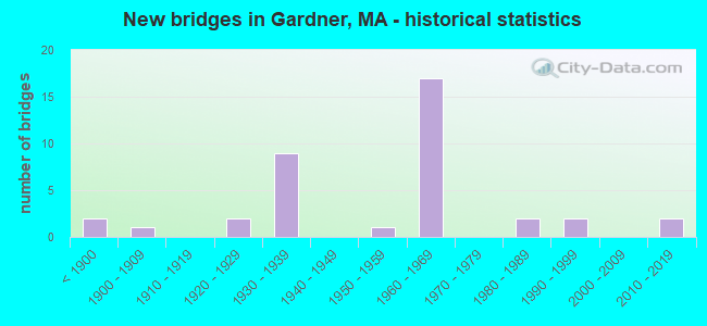
- New bridges - historical statistics
- 2Before 1900
- 11900-1909
- 21920-1929
- 91930-1939
- 11950-1959
- 171960-1969
- 21980-1989
- 21990-1999
- 22010-2019

- Reconstructed bridges - Historical Statistics
- 11920-1929
- 01930-1939
- 01940-1949
- 01950-1959
- 01960-1969
- 31970-1979
- 31980-1989
- 21990-1999
- 62000-2009


- Bridge Condition - Deck
- 14.3%Very good
- 25.7%Good
- 42.9%Satisfactory
- 17.1%Fair

- Bridge Condition - Superstructure
- 20.0%Very good
- 25.7%Good
- 22.9%Satisfactory
- 25.7%Fair
- 5.7%Poor

- Bridge Condition - Substructure
- 11.4%Very good
- 42.9%Good
- 28.6%Satisfactory
- 14.3%Fair
- 2.9%Poor

- Bridge Condition - Channel
- 29.4%Very good
- 23.5%Good
- 29.4%Satisfactory
- 17.6%Fair

- Bridge Condition - Culverts
- 33.3%Good
- 66.7%Fair
Find on map >> Show street view
Structure Number: CEPNEDMA2510001, Location: JUNCT MA RTES 25,28, & 6 (Lat: 41.776217, Lng: -70.543639), Route carried "on" structure: State highway 28, Year Built: 1935, Year Reconstructed: 1981, Status: Posted for load, Structure Length: 72.66m (238.39ft), Average Daily Traffic: 44,240 (year 2019), Truck Traffic: 20%, Average Future Daily Traffic: 79,000 (year 2040), Design Load: HS 20, Features Intersected: CAPE COD CANAL
Minimum Vertical Clearance: 30+ m (98+ ft), Kilometerpoint: 0.001, Lanes on structure: 4, Owner: Corps of Engineers (Civil), Approaching Roadway Width: 14.8m (48.6ft), Navigation Control: Yes ( Vertical Clearance: 41.0m (134.5ft), Horizontal Clearance: 146.3m (480.0ft)), Material/Design: Steel, Design/Construction: Arch - Thru, Number Of Spans In Main Unit: 3, Number Of Approach Spans: 4, Length of Maximum Span: 187.7m (615.8ft), Curb or Sidewalk Widths: Left: 2.0m (6.6ft), Right: 0.6m (2.0ft), Curb-To-Curb Width: 12.1m (39.7ft), Out-to-Out Width: 14.8m (48.6ft)
Condition: Deck: Fair, Superstructure: Poor, Substructure: Good, Channel: Satisfactory, Operating Rating: 26.6 metric tons, Method Used To Determine Operating Rating: Load and Resistance Factor Rating (LRFR) rating reported by rating factor(RF) method using HL-93 loadings, Inventory Rating: 20.1 metric tons, Method Used To Determine Inventory Rating: Load and Resistance Factor Rating (LRFR) rating reported by rating factor(RF) method using HL-93 loadings, Structural Evaluation: Meets minimum limits, Deck Geometry: High priority of replacement, Waterway Adequacy: Equal to present desirable criteria, Approach Roadway Alignment: Somewhat better than minimum adequacy, Length Of Structure Improvement: 76.29m (250.30ft), Designated Inspection Frequency: Every 24 months, Critical Feature Inspection Frequency: Every 24 months, Underwater Inspection Frequency: Every 60 months, Inspection Date: October 2020, Critical Feature Inspection Date: October 2020, Underwater Inspection Date: October 2020, Bridge Improvement Cost: $5,651,000, Roadway Improvement Cost: $565,000, Total Project Cost: $8,477,000 ( Estimate for 2021), Deck Structure Type: Closed Grating, Wearing Surface/Protective System: Wearing Surface: Bituminous, Membrane: Preformed Fabric
Find on map >> Show street view
Structure Number: CEPNEDMA2510011, Location: 12.9 KM S OF GARDNER (Lat: 42.428656, Lng: -72.028094), Route carried "on" structure: ServiceFederal lands road , Year Built: 1957, Status: Posted for load, Structure Length: 2.95m (9.68ft), Average Daily Traffic: 75 (year 2016), Truck Traffic: 4%, Average Future Daily Traffic: 50 (year 2040), Design Load: H 15, Features Intersected: SPILLWAY CHANNEL, Facility Carried by Structure: ACCESS ROAD
Minimum Vertical Clearance: 30+ m (98+ ft), Kilometerpoint: 0.000, Lanes on structure: 2, Owner: Corps of Engineers (Civil), Approaching Roadway Width: 5.4m (17.7ft), Material/Design: Steel, Design/Construction: Stringer/Multi-beam, Number Of Spans In Main Unit: 1, Length of Maximum Span: 28.9m (94.8ft), Curb or Sidewalk Widths: Left: 0.3m (1.0ft), Right: 0.3m (1.0ft), Curb-To-Curb Width: 5.4m (17.7ft), Out-to-Out Width: 6.3m (20.7ft)
Condition: Deck: Satisfactory, Superstructure: Satisfactory, Substructure: Good, Channel: Very good, Operating Rating: 26.9 metric tons, Method Used To Determine Operating Rating: Load Factor (LF), Inventory Rating: 16.2 metric tons, Method Used To Determine Inventory Rating: Load Factor (LF), Structural Evaluation: Somewhat better than minimum adequacy, Deck Geometry: High priority of corrective action, Waterway Adequacy: Superior to present desirable criteria, Approach Roadway Alignment: Equal to present minimum criteria, Length Of Structure Improvement: 5.69m (18.67ft), Designated Inspection Frequency: Every 24 months, Critical Feature Inspection Frequency: Every 24 months, Inspection Date: September 2020, Critical Feature Inspection Date: September 2020, Bridge Improvement Cost: $329,000, Roadway Improvement Cost: $1,000, Total Project Cost: $330,000 ( Estimate for 2020), Deck Structure Type: Concrete Cast-file-Place, Wearing Surface/Protective System: Wearing Surface: Epoxy Overlay
Find on map >> Show street view
Structure Number: CEPNEDMA2510012, Location: 12.9 KM S OF GARDNER (Lat: 42.390833, Lng: -72.040575), Route carried "on" structure: ServiceFederal lands road , Year Built: 1938, Status: Open, Structure Length: 1.66m (5.45ft), Average Daily Traffic: 20 (year 2014), Average Future Daily Traffic: 20 (year 2042), Design Load: H 15, Features Intersected: MUDDY POND BROOK, Facility Carried by Structure: PINE PLAINS ROAD
Minimum Vertical Clearance: 30+ m (98+ ft), Kilometerpoint: 0.000, Lanes on structure: 2, Owner: Corps of Engineers (Civil), Approaching Roadway Width: 6.0m (19.7ft), Material/Design: Steel, Design/Construction: Culvert, Number Of Spans In Main Unit: 2, Length of Maximum Span: 4.3m (14.1ft), Curb or Sidewalk Widths: Left: 0.4m (1.3ft), Right: 0.4m (1.3ft), Curb-To-Curb Width: 6.0m (19.7ft), Out-to-Out Width: 7.1m (23.3ft)
Condition: Channel: Very good, Culverts: Good, Structural Evaluation: Better than present minimum criteria, Deck Geometry: Meets minimum limits, Waterway Adequacy: Equal to present minimum criteria, Approach Roadway Alignment: Superior to present desirable criteria, Length Of Structure Improvement: 3.25m (10.66ft), Designated Inspection Frequency: Every 24 months, Inspection Date: July 2020, Bridge Improvement Cost: $20,000, Roadway Improvement Cost: $2,000, Total Project Cost: $22,000 ( Estimate for 2014), Wearing Surface/Protective System: Wearing Surface: Gravel
Find on map >> Show street view
Structure Number: CEPNEDMA2510015, Location: 16.09 KM N OF GARDNER (Lat: 42.651514, Lng: -72.108656), Route carried "on" structure: ServiceFederal lands road , Year Built: 1925, Year Reconstructed: 1979, Status: Posted for load, Structure Length: 0.78m (2.56ft), Average Daily Traffic: 20 (year 2019), Average Future Daily Traffic: 50 (year 2039), Design Load: H 15, Features Intersected: PRIEST BROOK, Facility Carried by Structure: BURGESS ROAD
Minimum Vertical Clearance: 30+ m (98+ ft), Kilometerpoint: 0.000, Lanes on structure: 1, Owner: Corps of Engineers (Civil), Approaching Roadway Width: 4.9m (16.1ft), Material/Design: Prestressed concrete, Design/Construction: Slab, Number Of Spans In Main Unit: 1, Length of Maximum Span: 7.1m (23.3ft), Curb or Sidewalk Widths: Left: 0.3m (1.0ft), Right: 0.3m (1.0ft), Curb-To-Curb Width: 4.2m (13.8ft), Out-to-Out Width: 4.9m (16.1ft)
Condition: Deck: Good, Superstructure: Good, Substructure: Satisfactory, Channel: Satisfactory, Operating Rating: 49.6 metric tons, Method Used To Determine Operating Rating: Load and Resistance Factor Rating (LRFR) rating reported by rating factor(RF) method using HL-93 loadings, Inventory Rating: 38.2 metric tons, Method Used To Determine Inventory Rating: Load and Resistance Factor Rating (LRFR) rating reported by rating factor(RF) method using HL-93 loadings, Structural Evaluation: Equal to present minimum criteria, Deck Geometry: Somewhat better than minimum adequacy, Waterway Adequacy: Equal to present desirable criteria, Approach Roadway Alignment: Equal to present minimum criteria, Length Of Structure Improvement: 1.53m (5.02ft), Designated Inspection Frequency: Every 24 months, Inspection Date: June 2021, Bridge Improvement Cost: $15,000, Roadway Improvement Cost: $8,000, Total Project Cost: $23,000 ( Estimate for 2015), Deck Structure Type: Concrete Precast Panels, Wearing Surface/Protective System: Wearing Surface: Bituminous, Deck Protection: Bituminous
Find on map >> Show street view
Structure Number: CEPNEDMA2510017, Location: 16.09 KM N OF GARDNER (Lat: 42.645339, Lng: -72.105003), Route carried "on" structure: ServiceFederal lands road , Year Built: 1937, Year Reconstructed: 1991, Status: Posted for load, Structure Length: 0.73m (2.40ft), Average Daily Traffic: 50 (year 2019), Average Future Daily Traffic: 50 (year 2039), Design Load: H 15, Features Intersected: PRIEST BROOK, Facility Carried by Structure: GOODNOW ROAD
Minimum Vertical Clearance: 30+ m (98+ ft), Kilometerpoint: 0.000, Lanes on structure: 2, Owner: Corps of Engineers (Civil), Approaching Roadway Width: 6.0m (19.7ft), Material/Design: Prestressed concrete, Design/Construction: Slab, Number Of Spans In Main Unit: 1, Length of Maximum Span: 6.4m (21.0ft), Curb or Sidewalk Widths: Left: 0.3m (1.0ft), Right: 0.3m (1.0ft), Curb-To-Curb Width: 6.0m (19.7ft), Out-to-Out Width: 6.8m (22.3ft)
Condition: Deck: Satisfactory, Superstructure: Good, Substructure: Satisfactory, Channel: Satisfactory, Operating Rating: 20.7 metric tons, Method Used To Determine Operating Rating: Load and Resistance Factor Rating (LRFR) rating reported by rating factor(RF) method using HL-93 loadings, Inventory Rating: 15.9 metric tons, Method Used To Determine Inventory Rating: Load and Resistance Factor Rating (LRFR) rating reported by rating factor(RF) method using HL-93 loadings, Structural Evaluation: Meets minimum limits, Waterway Adequacy: Equal to present desirable criteria, Approach Roadway Alignment: Equal to present minimum criteria, Length Of Structure Improvement: 1.45m (4.76ft), Designated Inspection Frequency: Every 24 months, Inspection Date: June 2021, Bridge Improvement Cost: $15,000, Roadway Improvement Cost: $1,000, Total Project Cost: $16,000 ( Estimate for 2017), Deck Structure Type: Concrete Precast Panels, Wearing Surface/Protective System: Wearing Surface: Bituminous, Deck Protection: Bituminous
Find on map >> Show street view
Structure Number: G010011Y5DOTNBI, Location: DIRECTLY ON TEMPLETON T.L (Lat: 42.573764, Lng: -72.016092), Route carried "on" structure: State highway 101, Year Built: 1963, Status: Open, Structure Length: 1.19m (3.90ft), Average Daily Traffic: 4,319 (year 2018), Truck Traffic: 5%, Average Future Daily Traffic: 12,319 (year 2033), Features Intersected: WATER OTTER RIVER
Minimum Vertical Clearance: 30+ m (98+ ft), Kilometerpoint: 17.380, Lanes on structure: 2, Owner: State Highway Agency, Approaching Roadway Width: 13.7m (44.9ft), Material/Design: Prestressed concrete, Design/Construction: Slab, Number Of Spans In Main Unit: 1, Length of Maximum Span: 11.3m (37.1ft), Curb or Sidewalk Widths: Left: 1.2m (3.9ft), Right: 0.0m, Curb-To-Curb Width: 13.7m (44.9ft), Out-to-Out Width: 20.7m (67.9ft)
Condition: Deck: Satisfactory, Superstructure: Satisfactory, Substructure: Good, Channel: Satisfactory, Operating Rating: 60.5 metric tons, Method Used To Determine Operating Rating: Load Factor (LF), Inventory Rating: 47.8 metric tons, Method Used To Determine Inventory Rating: Load Factor (LF), Structural Evaluation: Equal to present minimum criteria, Deck Geometry: Superior to present desirable criteria, Waterway Adequacy: Equal to present desirable criteria, Approach Roadway Alignment: Equal to present desirable criteria, Length Of Structure Improvement: 1.20m (3.94ft), Designated Inspection Frequency: Every 24 months, Underwater Inspection Frequency: Every 36 months, Inspection Date: January 2022, Underwater Inspection Date: January 2022, Bridge Improvement Cost: $196,000, Roadway Improvement Cost: $20,000, Total Project Cost: $295,000 ( Estimate for 2022), Deck Structure Type: Concrete Precast Panels, Wearing Surface/Protective System: Wearing Surface: Bituminous, Membrane: Built-up
Find on map >> Show street view
Structure Number: G010021FQMUNNBI, Location: 0.5 MI. S. OF ST-68 (Lat: 42.588383, Lng: -72.041172), Route carried "on" structure: City street , Year Built: 1937, Year Reconstructed: 2002, Status: Open, Structure Length: 0.88m (2.89ft), Average Daily Traffic: 400 (year 2018), Truck Traffic: 1%, Average Future Daily Traffic: 632 (year 2031), Design Load: HS 20, Features Intersected: WATER OTTER RIVER, Facility Carried by Structure: HWY BRIDGE ST
Minimum Vertical Clearance: 30+ m (98+ ft), Kilometerpoint: 0.563, Lanes on structure: 2, Owner: City or Municipal Highway Agency, Approaching Roadway Width: 7.3m (24.0ft), Skew: 1 degrees, Material/Design: Prestressed concrete, Design/Construction: Slab, Number Of Spans In Main Unit: 1, Length of Maximum Span: 7.8m (25.6ft), Curb or Sidewalk Widths: Left: 1.5m (4.9ft), Right: 0.2m (0.7ft), Curb-To-Curb Width: 7.3m (24.0ft), Out-to-Out Width: 8.8m (28.9ft)
Condition: Deck: Good, Superstructure: Good, Substructure: Good, Channel: Very good, Operating Rating: 74.2 metric tons, Method Used To Determine Operating Rating: Load Factor (LF), Inventory Rating: 56.1 metric tons, Method Used To Determine Inventory Rating: Load Factor (LF), Structural Evaluation: Better than present minimum criteria, Deck Geometry: Somewhat better than minimum adequacy, Waterway Adequacy: Equal to present desirable criteria, Approach Roadway Alignment: Equal to present desirable criteria, Length Of Structure Improvement: 0.90m (2.95ft), Designated Inspection Frequency: Every 24 months, Inspection Date: May 2020, Bridge Improvement Cost: $314,000, Roadway Improvement Cost: $32,000, Total Project Cost: $472,000 ( Estimate for 2022), Deck Structure Type: Concrete Precast Panels, Wearing Surface/Protective System: Wearing Surface: Bituminous, Membrane: Built-up, Deck Protection: Epoxy Coated Reinforcing
Find on map >> Show street view
Structure Number: G010031KMDOTNBI, Location: .5 MI E OF ST-68 (Lat: 42.559292, Lng: -71.984311), Route carried "on" structure: Alternate State highway 2A, Year Built: 1924, Year Reconstructed: 1929, Status: Open, Structure Length: 0.87m (2.85ft), Average Daily Traffic: 4,916 (year 2020), Truck Traffic: 5%, Average Future Daily Traffic: 12,161 (year 2033), Features Intersected: WATER BENT TRAVERS POND, Facility Carried by Structure: ST 2 A/W BROADWAY
Minimum Vertical Clearance: 30+ m (98+ ft), Kilometerpoint: 0.000, Lanes on structure: 2, Owner: State Highway Agency, Approaching Roadway Width: 10.8m (35.4ft), Skew: 1 degrees, Material/Design: Steel, Design/Construction: Stringer/Multi-beam, Number Of Spans In Main Unit: 1, Length of Maximum Span: 7.2m (23.6ft), Curb or Sidewalk Widths: Left: 1.5m (4.9ft), Right: 0.0m, Curb-To-Curb Width: 12.5m (41.0ft), Out-to-Out Width: 15.1m (49.5ft)
Condition: Deck: Fair, Superstructure: Fair, Substructure: Fair, Channel: Fair, Operating Rating: 58.5 metric tons, Method Used To Determine Operating Rating: Load Factor (LF), Inventory Rating: 35.0 metric tons, Method Used To Determine Inventory Rating: Load Factor (LF), Structural Evaluation: Somewhat better than minimum adequacy, Deck Geometry: Equal to present minimum criteria, Waterway Adequacy: Equal to present minimum criteria, Approach Roadway Alignment: Equal to present desirable criteria, Length Of Structure Improvement: 0.90m (2.95ft), Designated Inspection Frequency: Every 12 months, Underwater Inspection Frequency: Every 12 months, Inspection Date: Febuary 2022, Underwater Inspection Date: August 2021, Bridge Improvement Cost: $534,000, Roadway Improvement Cost: $54,000, Total Project Cost: $802,000 ( Estimate for 2022), Deck Structure Type: Concrete Cast-file-Place, Wearing Surface/Protective System: Wearing Surface: Bituminous
Find on map >> Show street view
Structure Number: G010041YDDOTNBI, Location: .5 MI N OF BETTY SPRNG RD (Lat: 42.574369, Lng: -71.948389), Route carried "on" structure: State highway 140, Year Built: 1980, Year Reconstructed: 2013, Status: Open, Structure Length: 1.92m (6.30ft), Average Daily Traffic: 11,416 (year 2014), Truck Traffic: 15%, Average Future Daily Traffic: 16,583 (year 2031), Design Load: H 20, Features Intersected: RR BMRR
Minimum Vertical Clearance: 30+ m (98+ ft), Kilometerpoint: 159.644, Lanes on structure: 2, Base Highway Network: Yes, Owner: State Highway Agency, Approaching Roadway Width: 13.4m (44.0ft), Skew: 2 degrees, Material/Design: Prestressed concrete, Design/Construction: Box Beam or Girders - Multiple, Number Of Spans In Main Unit: 1, Length of Maximum Span: 16.8m (55.1ft), Curb or Sidewalk Widths: Left: 0.3m (1.0ft), Right: 0.3m (1.0ft), Curb-To-Curb Width: 13.4m (44.0ft), Out-to-Out Width: 14.9m (48.9ft)
Condition: Deck: Very good, Superstructure: Very good, Substructure: Good, Operating Rating: 64.8 metric tons, Method Used To Determine Operating Rating: Load and Resistance Factor Rating (LRFR) rating reported by rating factor(RF) method using HL-93 loadings, Inventory Rating: 51.8 metric tons, Method Used To Determine Inventory Rating: Load and Resistance Factor Rating (LRFR) rating reported by rating factor(RF) method using HL-93 loadings, Structural Evaluation: Better than present minimum criteria, Deck Geometry: Equal to present minimum criteria, Underclear: Better than present minimum criteria, Approach Roadway Alignment: Equal to present desirable criteria, Designated Inspection Frequency: Every 24 months, Inspection Date: April 2020, Deck Structure Type: Concrete Precast Panels, Wearing Surface/Protective System: Wearing Surface: Bituminous, Membrane: Built-up, Deck Protection: Epoxy Coated Reinforcing
Find on map >> Show street view
Structure Number: G0100521UDOT634, Location: .3 MILES WEST OF ST. 140 (Lat: 42.568422, Lng: -71.954428), Route carried "on" structure: City street , Year Built: 1990, Status: Open, Structure Length: 4.36m (14.30ft), Average Daily Traffic: 1,300 (year 2014), Truck Traffic: 6%, Average Future Daily Traffic: 2,053 (year 2033), Design Load: HS 20, Features Intersected: RR BMRR, Facility Carried by Structure: HWY BETTY SPRING
Minimum Vertical Clearance: 30+ m (98+ ft), Kilometerpoint: 0.000, Lanes on structure: 2, Owner: State Highway Agency, Approaching Roadway Width: 9.8m (32.2ft), Skew: 1 degrees, Material/Design: Prestressed concrete, Design/Construction: Slab, Number Of Spans In Main Unit: 3, Length of Maximum Span: 16.6m (54.5ft), Curb or Sidewalk Widths: Left: 1.5m (4.9ft), Right: 0.2m (0.7ft), Curb-To-Curb Width: 9.8m (32.2ft), Out-to-Out Width: 12.3m (40.4ft)
Condition: Deck: Fair, Superstructure: Fair, Substructure: Satisfactory, Operating Rating: 71.5 metric tons, Method Used To Determine Operating Rating: Load Factor (LF), Inventory Rating: 43.0 metric tons, Method Used To Determine Inventory Rating: Load Factor (LF), Structural Evaluation: Somewhat better than minimum adequacy, Deck Geometry: Somewhat better than minimum adequacy, Underclear: Superior to present desirable criteria, Approach Roadway Alignment: Equal to present minimum criteria, Length Of Structure Improvement: 4.40m (14.44ft), Designated Inspection Frequency: Every 24 months, Inspection Date: Febuary 2022, Bridge Improvement Cost: $2,126,000, Roadway Improvement Cost: $213,000, Total Project Cost: $3,190,000 ( Estimate for 2022), Deck Structure Type: Concrete Precast Panels, Wearing Surface/Protective System: Wearing Surface: Bituminous, Membrane: Built-up, Deck Protection: Epoxy Coated Reinforcing
Find on map >> Show street view
Structure Number: G0100821TDOT634, Location: .1 MI. NORTH OF ST-2A (Lat: 42.565769, Lng: -71.996789), Route carried "on" structure: City street , Year Built: 1885, Year Reconstructed: 2021, Status: Open, Structure Length: 1.49m (4.89ft), Average Daily Traffic: 4,000 (year 2014), Truck Traffic: 3%, Average Future Daily Traffic: 6,317 (year 2031), Design Load: HL 93, Features Intersected: RR BMRR, Facility Carried by Structure: HWY PLEASANT ST
Minimum Vertical Clearance: 30+ m (98+ ft), Kilometerpoint: 0.161, Lanes on structure: 2, Owner: State Highway Agency, Approaching Roadway Width: 9.1m (29.9ft), Skew: 3 degrees, Material/Design: Steel, Design/Construction: Stringer/Multi-beam, Number Of Spans In Main Unit: 1, Length of Maximum Span: 14.3m (46.9ft), Curb or Sidewalk Widths: Left: 0.0m, Right: 1.5m (4.9ft), Curb-To-Curb Width: 9.1m (29.9ft), Out-to-Out Width: 11.8m (38.7ft)
Condition: Deck: Very good, Superstructure: Very good, Substructure: Very good, Operating Rating: 42.1 metric tons, Method Used To Determine Operating Rating: Assigned ratings based on Load and Resistance Factor Design (LRFD) reported by rating factor (RF) using HL93 loadings, Inventory Rating: 32.4 metric tons, Method Used To Determine Inventory Rating: Assigned ratings based on Load and Resistance Factor Design (LRFD) reported by rating factor (RF) using HL93 loadings, Structural Evaluation: Equal to present desirable criteria, Deck Geometry: Meets minimum limits, Underclear: High priority of corrective action, Approach Roadway Alignment: Somewhat better than minimum adequacy, Designated Inspection Frequency: Every 24 months, Inspection Date: September 2021, Deck Structure Type: Concrete Cast-file-Place, Wearing Surface/Protective System: Wearing Surface: Monolithic Concrete, Deck Protection: Epoxy Coated Reinforcing
Find on map >> Show street view
Structure Number: G0101021XDOT634, Location: @ CORNER OF SHERMAN ST (Lat: 42.575239, Lng: -71.990589), Route carried "on" structure: City street , Year Built: 1874, Year Reconstructed: 1981, Status: Open, Structure Length: 1.22m (4.00ft), Average Daily Traffic: 1,500 (year 2020), Truck Traffic: 5%, Average Future Daily Traffic: 2,053 (year 2033), Design Load: H 20, Features Intersected: RR BMRR SPUR, Facility Carried by Structure: HWY CROSS ST
Minimum Vertical Clearance: 30+ m (98+ ft), Kilometerpoint: 0.161, Lanes on structure: 2, Owner: State Highway Agency, Approaching Roadway Width: 7.9m (25.9ft), Skew: 3 degrees, Material/Design: Steel, Design/Construction: Stringer/Multi-beam, Number Of Spans In Main Unit: 1, Length of Maximum Span: 9.4m (30.8ft), Curb or Sidewalk Widths: Left: 1.8m (5.9ft), Right: 1.8m (5.9ft), Curb-To-Curb Width: 7.8m (25.6ft), Out-to-Out Width: 12.2m (40.0ft)
Condition: Deck: Satisfactory, Superstructure: Fair, Substructure: Satisfactory, Operating Rating: 36.9 metric tons, Method Used To Determine Operating Rating: Allowable Stress (AS), Inventory Rating: 33.0 metric tons, Method Used To Determine Inventory Rating: Allowable Stress (AS), Structural Evaluation: Somewhat better than minimum adequacy, Deck Geometry: Meets minimum limits, Underclear: High priority of corrective action, Approach Roadway Alignment: Equal to present desirable criteria, Length Of Structure Improvement: 1.30m (4.27ft), Designated Inspection Frequency: Every 24 months, Inspection Date: Febuary 2022, Bridge Improvement Cost: $623,000, Roadway Improvement Cost: $63,000, Total Project Cost: $935,000 ( Estimate for 2022), Deck Structure Type: Concrete Cast-file-Place, Wearing Surface/Protective System: Wearing Surface: Bituminous, Membrane: Built-up
Find on map >> Show street view
Structure Number: G0101121WDOT634, Location: BETWEEN CHESTNUT & PINE (Lat: 42.571667, Lng: -71.985247), Route carried "on" structure: City street , Year Built: 1930, Year Reconstructed: 1998, Status: Open, Structure Length: 1.12m (3.67ft), Average Daily Traffic: 1,100 (year 2016), Truck Traffic: 15%, Average Future Daily Traffic: 1,737 (year 2033), Design Load: HS 20, Features Intersected: RR BMRR, Facility Carried by Structure: HWY LOGAN ST
Minimum Vertical Clearance: 30+ m (98+ ft), Kilometerpoint: 0.483, Lanes on structure: 2, Owner: State Highway Agency, Approaching Roadway Width: 8.5m (27.9ft), Material/Design: Prestressed concrete, Design/Construction: Slab, Number Of Spans In Main Unit: 1, Length of Maximum Span: 9.7m (31.8ft), Curb or Sidewalk Widths: Left: 0.0m, Right: 1.5m (4.9ft), Curb-To-Curb Width: 8.5m (27.9ft), Out-to-Out Width: 10.9m (35.8ft)
Condition: Deck: Satisfactory, Superstructure: Satisfactory, Substructure: Fair, Operating Rating: 72.9 metric tons, Method Used To Determine Operating Rating: Load Factor (LF), Inventory Rating: 43.7 metric tons, Method Used To Determine Inventory Rating: Load Factor (LF), Structural Evaluation: Somewhat better than minimum adequacy, Deck Geometry: Somewhat better than minimum adequacy, Underclear: High priority of corrective action, Approach Roadway Alignment: Equal to present minimum criteria, Length Of Structure Improvement: 1.20m (3.94ft), Designated Inspection Frequency: Every 24 months, Inspection Date: January 2022, Bridge Improvement Cost: $514,000, Roadway Improvement Cost: $52,000, Total Project Cost: $772,000 ( Estimate for 2022), Deck Structure Type: Concrete Precast Panels, Wearing Surface/Protective System: Wearing Surface: Bituminous, Membrane: Built-up, Deck Protection: Epoxy Coated Reinforcing
Find on map >> Show street view
Structure Number: G0101221RDOT634, Location: 0.6 MI E OF ST-68 (Lat: 42.555617, Lng: -71.984128), Route carried "on" structure: City street , Year Built: 1908, Year Reconstructed: 1986, Status: Open, Structure Length: 1.56m (5.12ft), Average Daily Traffic: 2,000 (year 1995), Truck Traffic: 6%, Average Future Daily Traffic: 6,949 (year 2032), Design Load: HS 20, Features Intersected: RR PWRR, Facility Carried by Structure: HWY UNION ST
Minimum Vertical Clearance: 30+ m (98+ ft), Kilometerpoint: 0.322, Lanes on structure: 2, Owner: State Highway Agency, Approaching Roadway Width: 9.1m (29.9ft), Skew: 3 degrees, Material/Design: Prestressed concrete, Design/Construction: Slab, Number Of Spans In Main Unit: 1, Length of Maximum Span: 12.5m (41.0ft), Curb or Sidewalk Widths: Left: 1.9m (6.2ft), Right: 0.6m (2.0ft), Curb-To-Curb Width: 9.1m (29.9ft), Out-to-Out Width: 11.7m (38.4ft)
Condition: Deck: Fair, Superstructure: Fair, Substructure: Good, Operating Rating: 64.4 metric tons, Method Used To Determine Operating Rating: Load Factor (LF), Inventory Rating: 38.4 metric tons, Method Used To Determine Inventory Rating: Load Factor (LF), Structural Evaluation: Somewhat better than minimum adequacy, Deck Geometry: Somewhat better than minimum adequacy, Underclear: High priority of corrective action, Approach Roadway Alignment: Better than present minimum criteria, Length Of Structure Improvement: 1.60m (5.25ft), Designated Inspection Frequency: Every 24 months, Inspection Date: January 2021, Bridge Improvement Cost: $736,000, Roadway Improvement Cost: $74,000, Total Project Cost: $1,105,000 ( Estimate for 2022), Deck Structure Type: Concrete Precast Panels, Wearing Surface/Protective System: Wearing Surface: Bituminous, Membrane: Built-up, Deck Protection: Epoxy Coated Reinforcing
Find on map >> Show street view
Structure Number: G01017B6QMUNNBI, Location: 250 FT. S. OF MILL ST (Lat: 42.556578, Lng: -71.986644), Route carried "on" structure: City street , Year Built: 2012, Status: Open, Structure Length: 0.84m (2.76ft), Average Daily Traffic: 800 (year 2012), Truck Traffic: 6%, Design Load: HS 25 or greater, Features Intersected: WATER BAKER BROOK, Facility Carried by Structure: HWY WINTER ST
Minimum Vertical Clearance: 99.00m (324.80ft), Kilometerpoint: 0.177, Lanes on structure: 2, Owner: City or Municipal Highway Agency, Approaching Roadway Width: 7.3m (24.0ft), Material/Design: Concrete, Design/Construction: Slab, Number Of Spans In Main Unit: 1, Length of Maximum Span: 8.4m (27.6ft), Curb or Sidewalk Widths: Left: 1.7m (5.6ft), Right: 0.0m, Curb-To-Curb Width: 7.3m (24.0ft), Out-to-Out Width: 9.9m (32.5ft)
Condition: Deck: Very good, Superstructure: Very good, Substructure: Very good, Channel: Good, Inventory Rating: 71.6 metric tons, Method Used To Determine Inventory Rating: Load Factor (LF), Structural Evaluation: Equal to present desirable criteria, Deck Geometry: Meets minimum limits, Waterway Adequacy: Better than present minimum criteria, Approach Roadway Alignment: Equal to present minimum criteria, Length Of Structure Improvement: 0.90m (2.95ft), Designated Inspection Frequency: Every 24 months, Underwater Inspection Frequency: Every 25 months, Inspection Date: December 2020, Underwater Inspection Date: November 2020, Bridge Improvement Cost: $416,000, Roadway Improvement Cost: $42,000, Total Project Cost: $625,000 ( Estimate for 2022), Deck Structure Type: Concrete Cast-file-Place, Wearing Surface/Protective System: Wearing Surface: Bituminous, Membrane: Preformed Fabric, Deck Protection: Epoxy Coated Reinforcing
Find on map >> Show street view
Structure Number: G01019ADYMUNNBI, Location: 0.2 MI SW OF ROUTE 68 (Lat: 42.555078, Lng: -71.994803), Route carried "on" structure: City street , Year Built: 1998, Status: Open, Structure Length: 1.37m (4.49ft), Average Daily Traffic: 250 (year 2014), Truck Traffic: 2%, Average Future Daily Traffic: 395 (year 2031), Design Load: HS 20+Mod, Features Intersected: WATER BAKER BROOK, Facility Carried by Structure: HWY MILL ST
Minimum Vertical Clearance: 30+ m (98+ ft), Kilometerpoint: 0.789, Lanes on structure: 2, Owner: City or Municipal Highway Agency, Approaching Roadway Width: 7.4m (24.3ft), Material/Design: Prestressed concrete, Design/Construction: Slab, Number Of Spans In Main Unit: 1, Length of Maximum Span: 12.7m (41.7ft), Curb or Sidewalk Widths: Left: 0.0m, Right: 1.6m (5.2ft), Curb-To-Curb Width: 7.4m (24.3ft), Out-to-Out Width: 9.6m (31.5ft)
Condition: Deck: Satisfactory, Superstructure: Satisfactory, Substructure: Good, Channel: Good, Operating Rating: 66.6 metric tons, Method Used To Determine Operating Rating: Allowable Stress (AS), Inventory Rating: 48.6 metric tons, Method Used To Determine Inventory Rating: Allowable Stress (AS), Structural Evaluation: Equal to present minimum criteria, Deck Geometry: Somewhat better than minimum adequacy, Waterway Adequacy: Better than present minimum criteria, Approach Roadway Alignment: Better than present minimum criteria, Length Of Structure Improvement: 1.40m (4.59ft), Designated Inspection Frequency: Every 24 months, Inspection Date: December 2020, Bridge Improvement Cost: $476,000, Roadway Improvement Cost: $48,000, Total Project Cost: $715,000 ( Estimate for 2022), Deck Structure Type: Concrete Precast Panels, Wearing Surface/Protective System: Wearing Surface: Bituminous, Membrane: Built-up, Deck Protection: Epoxy Coated Reinforcing
Find on map >> Show street view
Structure Number: G010211FLMUNNBI, Location: .1MI E OF RT68 BY RSDL PD (Lat: 42.555606, Lng: -71.991606), Route carried "on" structure: City street , Year Built: 1938, Status: Posted for load, Structure Length: 1.07m (3.51ft), Average Daily Traffic: 650 (year 2015), Truck Traffic: 25%, Average Future Daily Traffic: 1,027 (year 2032), Features Intersected: WATER BAKER BROOK, Facility Carried by Structure: HWY MILL ST
Minimum Vertical Clearance: 30+ m (98+ ft), Kilometerpoint: 1.094, Lanes on structure: 2, Owner: City or Municipal Highway Agency, Approaching Roadway Width: 9.1m (29.9ft), Material/Design: Steel, Design/Construction: Stringer/Multi-beam, Number Of Spans In Main Unit: 1, Length of Maximum Span: 9.1m (29.9ft), Curb or Sidewalk Widths: Left: 2.0m (6.6ft), Right: 0.2m (0.7ft), Curb-To-Curb Width: 9.1m (29.9ft), Out-to-Out Width: 12.3m (40.4ft)
Condition: Deck: Fair, Superstructure: Poor, Substructure: Satisfactory, Channel: Good, Operating Rating: 43.9 metric tons, Method Used To Determine Operating Rating: Load Factor (LF), Inventory Rating: 26.3 metric tons, Method Used To Determine Inventory Rating: Load Factor (LF), Structural Evaluation: Meets minimum limits, Deck Geometry: Equal to present minimum criteria, Waterway Adequacy: Equal to present desirable criteria, Approach Roadway Alignment: Equal to present minimum criteria, Length Of Structure Improvement: 1.80m (5.91ft), Designated Inspection Frequency: Every 24 months, Inspection Date: September 2021, Other Special Inspection Date: September 2021, Bridge Improvement Cost: $1,452,000, Roadway Improvement Cost: $146,000, Total Project Cost: $2,179,000 ( Estimate for 2022), Deck Structure Type: Concrete Cast-file-Place, Wearing Surface/Protective System: Wearing Surface: Bituminous
Find on map >> Show street view
Structure Number: G010221FMMUNNBI, Location: AT SAWYER ST (Lat: 42.550000, Lng: -72.000389), Route carried "on" structure: City street , Year Built: 1938, Year Reconstructed: 2012, Status: Open, Structure Length: 1.13m (3.71ft), Average Daily Traffic: 400 (year 2014), Truck Traffic: 6%, Average Future Daily Traffic: 632 (year 2031), Design Load: HS 25 or greater, Features Intersected: WATER BAKER BROOK, Facility Carried by Structure: HWY MILL ST
Minimum Vertical Clearance: 30+ m (98+ ft), Kilometerpoint: 0.161, Lanes on structure: 2, Owner: City or Municipal Highway Agency, Approaching Roadway Width: 9.4m (30.8ft), Skew: 1 degrees, Material/Design: Prestressed concrete, Design/Construction: Slab, Number Of Spans In Main Unit: 1, Length of Maximum Span: 10.4m (34.1ft), Curb-To-Curb Width: 9.4m (30.8ft), Out-to-Out Width: 10.4m (34.1ft)
Condition: Deck: Very good, Superstructure: Very good, Substructure: Good, Channel: Very good, Inventory Rating: 64.9 metric tons, Method Used To Determine Inventory Rating: Load Factor (LF), Structural Evaluation: Better than present minimum criteria, Deck Geometry: Equal to present minimum criteria, Waterway Adequacy: Equal to present desirable criteria, Approach Roadway Alignment: Better than present minimum criteria, Length Of Structure Improvement: 1.20m (3.94ft), Designated Inspection Frequency: Every 24 months, Inspection Date: August 2020, Bridge Improvement Cost: $182,000, Roadway Improvement Cost: $19,000, Total Project Cost: $274,000 ( Estimate for 2022), Deck Structure Type: Concrete Cast-file-Place, Wearing Surface/Protective System: Wearing Surface: Bituminous, Membrane: Preformed Fabric, Deck Protection: Epoxy Coated Reinforcing
Find on map >> Show street view
Structure Number: G010231FRMUNNBI, Location: 0.2 M N OF RT-2A (Lat: 42.560575, Lng: -71.983264), Route carried "on" structure: City street , Year Built: 2011, Status: Open, Structure Length: 1.67m (5.48ft), Average Daily Traffic: 744 (year 2018), Truck Traffic: 6%, Average Future Daily Traffic: 1,027 (year 2032), Design Load: HS 20, Features Intersected: WATER TRAVERS POND INLET, Facility Carried by Structure: HWY TRAVERS ST
Minimum Vertical Clearance: 30+ m (98+ ft), Kilometerpoint: 0.177, Lanes on structure: 2, Owner: City or Municipal Highway Agency, Approaching Roadway Width: 8.7m (28.5ft), Skew: 1 degrees, Material/Design: Prestressed concrete, Design/Construction: Box Beam or Girders - Single/Spread, Number Of Spans In Main Unit: 1, Length of Maximum Span: 15.2m (49.9ft), Curb or Sidewalk Widths: Left: 1.8m (5.9ft), Right: 0.0m, Curb-To-Curb Width: 8.7m (28.5ft), Out-to-Out Width: 11.3m (37.1ft)
Condition: Deck: Very good, Superstructure: Very good, Substructure: Good, Channel: Satisfactory, Operating Rating: 61.1 metric tons, Method Used To Determine Operating Rating: Load Factor (LF), Inventory Rating: 36.6 metric tons, Method Used To Determine Inventory Rating: Load Factor (LF), Structural Evaluation: Better than present minimum criteria, Deck Geometry: Somewhat better than minimum adequacy, Waterway Adequacy: Equal to present desirable criteria, Approach Roadway Alignment: Better than present minimum criteria, Length Of Structure Improvement: 1.70m (5.58ft), Designated Inspection Frequency: Every 24 months, Inspection Date: October 2021, Bridge Improvement Cost: $561,000, Roadway Improvement Cost: $57,000, Total Project Cost: $842,000 ( Estimate for 2022), Deck Structure Type: Concrete Cast-file-Place, Wearing Surface/Protective System: Wearing Surface: Bituminous, Membrane: Built-up, Deck Protection: Epoxy Coated Reinforcing
Find on map >> Show street view
Structure Number: G0102420KDOTNBI, Location: AT CORNER OF BRIDGE ST. (Lat: 42.591275, Lng: -72.034139), Route carried "on" structure: State highway 68, Year Built: 1939, Status: Open, Structure Length: 0.62m (2.03ft), Average Daily Traffic: 2,938 (year 2020), Truck Traffic: 6%, Average Future Daily Traffic: 8,686 (year 2032), Features Intersected: WATER BAILEY BROOK
Minimum Vertical Clearance: 30+ m (98+ ft), Kilometerpoint: 32.361, Lanes on structure: 2, Owner: State Highway Agency, Approaching Roadway Width: 9.7m (31.8ft), Skew: 4 degrees, Material/Design: Concrete, Design/Construction: Culvert, Number Of Spans In Main Unit: 1, Length of Maximum Span: 6.1m (20.0ft)
Condition: Channel: Fair, Culverts: Fair, Inventory Rating: 88.8 metric tons, Method Used To Determine Inventory Rating: Allowable Stress (AS), Structural Evaluation: Somewhat better than minimum adequacy, Waterway Adequacy: Equal to present desirable criteria, Approach Roadway Alignment: Better than present minimum criteria, Length Of Structure Improvement: 1.40m (4.59ft), Designated Inspection Frequency: Every 24 months, Inspection Date: July 2021, Bridge Improvement Cost: $249,000, Roadway Improvement Cost: $25,000, Total Project Cost: $374,000 ( Estimate for 2022)
Find on map >> Show street view
Structure Number: G010311NADOTNBI, Location: .5 MI. E. OF ST-68 (Lat: 42.564075, Lng: -71.978433), Route carried "on" structure: State highway 2, Year Built: 1961, Status: Open, Structure Length: 4.24m (13.91ft), Average Daily Traffic: 22,179 (year 2005), Truck Traffic: 15%, Average Future Daily Traffic: 47,379 (year 2031), Design Load: H 20, Features Intersected: HWY PEARSON BLVD NB
Minimum Vertical Clearance: 30+ m (98+ ft), Kilometerpoint: 140.411, Lanes on structure: 2, Lanes under structure: 2, Base Highway Network: Yes, Owner: State Highway Agency, Approaching Roadway Width: 11.6m (38.1ft), Material/Design: Steel, Design/Construction: Stringer/Multi-beam, Number Of Spans In Main Unit: 3, Length of Maximum Span: 18.3m (60.0ft), Curb-To-Curb Width: 11.6m (38.1ft), Out-to-Out Width: 13.4m (44.0ft)
Condition: Deck: Satisfactory, Superstructure: Fair, Substructure: Good, Operating Rating: 41.2 metric tons, Method Used To Determine Operating Rating: Load Factor (LF), Inventory Rating: 24.7 metric tons, Method Used To Determine Inventory Rating: Load Factor (LF), Structural Evaluation: Somewhat better than minimum adequacy, Deck Geometry: Equal to present minimum criteria, Underclear: Meets minimum limits, Approach Roadway Alignment: Equal to present desirable criteria, Length Of Structure Improvement: 4.30m (14.11ft), Designated Inspection Frequency: Every 24 months, Inspection Date: June 2020, Bridge Improvement Cost: $2,264,000, Roadway Improvement Cost: $227,000, Total Project Cost: $3,397,000 ( Estimate for 2022), Deck Structure Type: Concrete Cast-file-Place, Wearing Surface/Protective System: Wearing Surface: Bituminous, Membrane: Built-up
Find on map >> Show street view
Structure Number: G010311NBDOTNBI, Location: .5 M E OF ST. 68 (Lat: 42.563897, Lng: -71.978489), Route carried "on" structure: State highway 2, Year Built: 1961, Status: Open, Structure Length: 3.88m (12.73ft), Average Daily Traffic: 16,350 (year 2014), Truck Traffic: 15%, Average Future Daily Traffic: 25,822 (year 2031), Design Load: H 20, Features Intersected: HWY PEARSON BLVD NB
Minimum Vertical Clearance: 30+ m (98+ ft), Kilometerpoint: 140.411, Lanes on structure: 2, Lanes under structure: 2, Base Highway Network: Yes, Owner: State Highway Agency, Approaching Roadway Width: 11.6m (38.1ft), Material/Design: Steel, Design/Construction: Stringer/Multi-beam, Number Of Spans In Main Unit: 3, Length of Maximum Span: 17.4m (57.1ft), Curb or Sidewalk Widths: Left: 0.5m (1.6ft), Right: 0.5m (1.6ft), Curb-To-Curb Width: 11.6m (38.1ft), Out-to-Out Width: 13.4m (44.0ft)
Condition: Deck: Satisfactory, Superstructure: Fair, Substructure: Satisfactory, Operating Rating: 38.4 metric tons, Method Used To Determine Operating Rating: Allowable Stress (AS), Inventory Rating: 20.4 metric tons, Method Used To Determine Inventory Rating: Allowable Stress (AS), Structural Evaluation: Somewhat better than minimum adequacy, Deck Geometry: Equal to present minimum criteria, Underclear: Meets minimum limits, Approach Roadway Alignment: Equal to present desirable criteria, Length Of Structure Improvement: 3.90m (12.80ft), Designated Inspection Frequency: Every 24 months, Inspection Date: June 2020, Bridge Improvement Cost: $2,053,000, Roadway Improvement Cost: $206,000, Total Project Cost: $3,080,000 ( Estimate for 2022), Deck Structure Type: Concrete Cast-file-Place, Wearing Surface/Protective System: Wearing Surface: Bituminous, Membrane: Built-up
Find on map >> Show street view
Structure Number: G010321NCDOTNBI, Location: .7 MI E OF ST-68 (Lat: 42.564522, Lng: -71.979900), Route carried "on" structure: State highway 2, Year Built: 1961, Status: Open, Structure Length: 3.93m (12.89ft), Average Daily Traffic: 15,633 (year 2020), Truck Traffic: 6%, Average Future Daily Traffic: 55,276 (year 2032), Design Load: H 20, Features Intersected: HWY PEARSON BLVD SB
Minimum Vertical Clearance: 30+ m (98+ ft), Kilometerpoint: 140.411, Lanes on structure: 2, Lanes under structure: 1, Base Highway Network: Yes, Owner: State Highway Agency, Approaching Roadway Width: 11.6m (38.1ft), Skew: 2 degrees, Material/Design: Steel, Design/Construction: Stringer/Multi-beam, Number Of Spans In Main Unit: 3, Length of Maximum Span: 18.3m (60.0ft), Curb or Sidewalk Widths: Left: 0.2m (0.7ft), Right: 0.5m (1.6ft), Curb-To-Curb Width: 11.6m (38.1ft), Out-to-Out Width: 13.4m (44.0ft)
Condition: Deck: Satisfactory, Superstructure: Satisfactory, Substructure: Satisfactory, Operating Rating: 39.6 metric tons, Method Used To Determine Operating Rating: Allowable Stress (AS), Inventory Rating: 19.6 metric tons, Method Used To Determine Inventory Rating: Allowable Stress (AS), Structural Evaluation: Meets minimum limits, Deck Geometry: Equal to present minimum criteria, Underclear: Meets minimum limits, Approach Roadway Alignment: Equal to present desirable criteria, Length Of Structure Improvement: 4.00m (13.12ft), Designated Inspection Frequency: Every 24 months, Inspection Date: October 2021, Bridge Improvement Cost: $2,106,000, Roadway Improvement Cost: $211,000, Total Project Cost: $3,160,000 ( Estimate for 2022), Deck Structure Type: Concrete Cast-file-Place, Wearing Surface/Protective System: Wearing Surface: Bituminous, Membrane: Built-up
Find on map >> Show street view
Structure Number: G010321NDDOTNBI, Location: .7 MILES EAST OF ST. 68 (Lat: 42.564383, Lng: -71.980022), Route carried "on" structure: State highway 2, Year Built: 1961, Status: Open, Structure Length: 3.69m (12.11ft), Average Daily Traffic: 10,284 (year 2020), Truck Traffic: 6%, Average Future Daily Traffic: 25,269 (year 2032), Design Load: H 20, Features Intersected: HWY PEARSON BLVD SB
Minimum Vertical Clearance: 30+ m (98+ ft), Kilometerpoint: 140.411, Lanes on structure: 2, Lanes under structure: 1, Base Highway Network: Yes, Owner: State Highway Agency, Approaching Roadway Width: 11.6m (38.1ft), Material/Design: Steel, Design/Construction: Stringer/Multi-beam, Number Of Spans In Main Unit: 3, Length of Maximum Span: 17.4m (57.1ft), Curb or Sidewalk Widths: Left: 0.2m (0.7ft), Right: 0.2m (0.7ft), Curb-To-Curb Width: 11.6m (38.1ft), Out-to-Out Width: 13.4m (44.0ft)
Condition: Deck: Good, Superstructure: Satisfactory, Substructure: Satisfactory, Operating Rating: 39.6 metric tons, Method Used To Determine Operating Rating: Allowable Stress (AS), Inventory Rating: 19.6 metric tons, Method Used To Determine Inventory Rating: Allowable Stress (AS), Structural Evaluation: Meets minimum limits, Deck Geometry: Equal to present minimum criteria, Underclear: Meets minimum limits, Approach Roadway Alignment: Equal to present desirable criteria, Length Of Structure Improvement: 3.70m (12.14ft), Designated Inspection Frequency: Every 24 months, Inspection Date: October 2021, Bridge Improvement Cost: $1,948,000, Roadway Improvement Cost: $195,000, Total Project Cost: $2,923,000 ( Estimate for 2022), Deck Structure Type: Concrete Cast-file-Place, Wearing Surface/Protective System: Wearing Surface: Bituminous, Membrane: Built-up
Find on map >> Show street view
Structure Number: G010341NEDOTNBI, Location: .3 MI. E. OF ST 68 (Lat: 42.565822, Lng: -71.983058), Route carried "on" structure: State highway 2, Year Built: 1961, Status: Open, Structure Length: 2.01m (6.59ft), Average Daily Traffic: 18,000 (year 2013), Truck Traffic: 10%, Average Future Daily Traffic: 28,427 (year 2032), Design Load: H 20, Features Intersected: RR PWRR
Minimum Vertical Clearance: 30+ m (98+ ft), Kilometerpoint: 140.706, Lanes on structure: 3, Base Highway Network: Yes, Owner: State Highway Agency, Approaching Roadway Width: 12.8m (42.0ft), Skew: 4 degrees, Material/Design: Steel, Design/Construction: Stringer/Multi-beam, Number Of Spans In Main Unit: 1, Length of Maximum Span: 18.3m (60.0ft), Curb-To-Curb Width: 12.6m (41.3ft), Out-to-Out Width: 14.5m (47.6ft)
Condition: Deck: Satisfactory, Superstructure: Satisfactory, Substructure: Good, Operating Rating: 37.5 metric tons, Method Used To Determine Operating Rating: Allowable Stress (AS), Inventory Rating: 18.6 metric tons, Method Used To Determine Inventory Rating: Allowable Stress (AS), Structural Evaluation: Meets minimum limits, Deck Geometry: High priority of replacement, Underclear: Somewhat better than minimum adequacy, Approach Roadway Alignment: Equal to present desirable criteria, Length Of Structure Improvement: 2.10m (6.89ft), Designated Inspection Frequency: Every 24 months, Inspection Date: May 2021, Bridge Improvement Cost: $1,197,000, Roadway Improvement Cost: $120,000, Total Project Cost: $1,796,000 ( Estimate for 2022), Deck Structure Type: Concrete Cast-file-Place, Wearing Surface/Protective System: Wearing Surface: Bituminous, Membrane: Built-up
Find on map >> Show street view
Structure Number: G010341NFDOTNBI, Location: .3 MILES E OF ST-68 (Lat: 42.565481, Lng: -71.982839), Route carried "on" structure: State highway 2, Year Built: 1961, Status: Open, Structure Length: 2.23m (7.32ft), Average Daily Traffic: 18,742 (year 2018), Truck Traffic: 6%, Average Future Daily Traffic: 31,586 (year 2032), Design Load: H 20, Features Intersected: RR PWRR
Minimum Vertical Clearance: 30+ m (98+ ft), Kilometerpoint: 140.706, Lanes on structure: 3, Base Highway Network: Yes, Owner: State Highway Agency, Approaching Roadway Width: 16.2m (53.1ft), Skew: 4 degrees, Material/Design: Steel, Design/Construction: Stringer/Multi-beam, Number Of Spans In Main Unit: 1, Length of Maximum Span: 21.0m (68.9ft), Curb-To-Curb Width: 16.2m (53.1ft), Out-to-Out Width: 18.0m (59.1ft)
Condition: Deck: Satisfactory, Superstructure: Fair, Substructure: Fair, Operating Rating: 37.5 metric tons, Method Used To Determine Operating Rating: Allowable Stress (AS), Inventory Rating: 18.6 metric tons, Method Used To Determine Inventory Rating: Allowable Stress (AS), Structural Evaluation: Meets minimum limits, Deck Geometry: Equal to present minimum criteria, Underclear: Somewhat better than minimum adequacy, Approach Roadway Alignment: Equal to present desirable criteria, Length Of Structure Improvement: 2.30m (7.55ft), Designated Inspection Frequency: Every 24 months, Inspection Date: May 2021, Bridge Improvement Cost: $1,627,000, Roadway Improvement Cost: $163,000, Total Project Cost: $2,441,000 ( Estimate for 2022), Deck Structure Type: Concrete Cast-file-Place, Wearing Surface/Protective System: Wearing Surface: Bituminous, Membrane: Built-up
Find on map >> Show street view
Structure Number: G010351NGDOTNBI, Location: .5 MI.EST.OF ST-2A (Lat: 42.567025, Lng: -71.992272), Route carried "on" structure: State highway 2, Year Built: 1961, Year Reconstructed: 2011, Status: Open, Structure Length: 4.39m (14.40ft), Average Daily Traffic: 13,023 (year 2018), Truck Traffic: 7%, Average Future Daily Traffic: 31,586 (year 2032), Design Load: HS 20, Features Intersected: ST 68 NB/TIMPANY BLVD
Minimum Vertical Clearance: 30+ m (98+ ft), Kilometerpoint: 139.430, Lanes on structure: 2, Lanes under structure: 1, Base Highway Network: Yes, Owner: State Highway Agency, Approaching Roadway Width: 12.4m (40.7ft), Skew: 2 degrees, Material/Design: Steel continuous, Design/Construction: Stringer/Multi-beam, Number Of Spans In Main Unit: 3, Length of Maximum Span: 18.9m (62.0ft), Curb-To-Curb Width: 12.4m (40.7ft), Out-to-Out Width: 13.4m (44.0ft)
Condition: Deck: Good, Superstructure: Very good, Substructure: Very good, Operating Rating: 81.0 metric tons, Method Used To Determine Operating Rating: Load Factor (LF), Inventory Rating: 48.5 metric tons, Method Used To Determine Inventory Rating: Load Factor (LF), Structural Evaluation: Equal to present desirable criteria, Deck Geometry: Better than present minimum criteria, Underclear: Meets minimum limits, Approach Roadway Alignment: Equal to present desirable criteria, Length Of Structure Improvement: 4.40m (14.44ft), Designated Inspection Frequency: Every 24 months, Inspection Date: October 2021, Bridge Improvement Cost: $166,000, Roadway Improvement Cost: $17,000, Total Project Cost: $250,000 ( Estimate for 2022), Deck Structure Type: Concrete Cast-file-Place, Wearing Surface/Protective System: Wearing Surface: Bituminous, Membrane: Built-up, Deck Protection: Epoxy Coated Reinforcing
Find on map >> Show street view
Structure Number: G010351NHDOTNBI, Location: .5 MI. EAST OF ST-2A (Lat: 42.566869, Lng: -71.992125), Route carried "on" structure: State highway 2, Year Built: 1961, Year Reconstructed: 2011, Status: Open, Structure Length: 4.02m (13.19ft), Average Daily Traffic: 13,893 (year 2018), Truck Traffic: 7%, Average Future Daily Traffic: 31,586 (year 2032), Design Load: HS 25 or greater, Features Intersected: ST 68 NB/TIMPANY BLVD
Minimum Vertical Clearance: 30+ m (98+ ft), Kilometerpoint: 139.430, Lanes on structure: 2, Lanes under structure: 1, Base Highway Network: Yes, Owner: State Highway Agency, Approaching Roadway Width: 12.4m (40.7ft), Material/Design: Steel continuous, Design/Construction: Stringer/Multi-beam, Number Of Spans In Main Unit: 3, Length of Maximum Span: 16.0m (52.5ft), Curb-To-Curb Width: 12.4m (40.7ft), Out-to-Out Width: 13.5m (44.3ft)
Condition: Deck: Good, Superstructure: Good, Substructure: Good, Operating Rating: 81.0 metric tons, Method Used To Determine Operating Rating: Load Factor (LF), Inventory Rating: 48.5 metric tons, Method Used To Determine Inventory Rating: Load Factor (LF), Structural Evaluation: Better than present minimum criteria, Deck Geometry: Better than present minimum criteria, Underclear: Meets minimum limits, Approach Roadway Alignment: Equal to present desirable criteria, Length Of Structure Improvement: 4.10m (13.45ft), Designated Inspection Frequency: Every 24 months, Inspection Date: October 2021, Bridge Improvement Cost: $155,000, Roadway Improvement Cost: $16,000, Total Project Cost: $233,000 ( Estimate for 2022), Deck Structure Type: Concrete Cast-file-Place, Wearing Surface/Protective System: Wearing Surface: Bituminous, Membrane: Built-up, Deck Protection: Epoxy Coated Reinforcing
Find on map >> Show street view
Structure Number: G010361NJDOTNBI, Location: 1.5 MI E OF TEMPLETON TL (Lat: 42.566500, Lng: -71.993650), Route carried "on" structure: State highway 2, Year Built: 1961, Year Reconstructed: 2011, Status: Open, Structure Length: 4.33m (14.21ft), Average Daily Traffic: 13,023 (year 2018), Truck Traffic: 7%, Average Future Daily Traffic: 28,427 (year 2032), Design Load: HS 20, Features Intersected: ST 68 SB/TIMPANY BLVD
Minimum Vertical Clearance: 30+ m (98+ ft), Kilometerpoint: 139.285, Lanes on structure: 2, Lanes under structure: 1, Base Highway Network: Yes, Owner: State Highway Agency, Approaching Roadway Width: 12.4m (40.7ft), Skew: 1 degrees, Material/Design: Steel continuous, Design/Construction: Stringer/Multi-beam, Number Of Spans In Main Unit: 3, Length of Maximum Span: 19.1m (62.7ft), Curb-To-Curb Width: 12.4m (40.7ft), Out-to-Out Width: 13.4m (44.0ft)
Condition: Deck: Good, Superstructure: Very good, Substructure: Very good, Operating Rating: 81.0 metric tons, Method Used To Determine Operating Rating: Load Factor (LF), Inventory Rating: 48.5 metric tons, Method Used To Determine Inventory Rating: Load Factor (LF), Structural Evaluation: Equal to present desirable criteria, Deck Geometry: Better than present minimum criteria, Underclear: Meets minimum limits, Approach Roadway Alignment: Equal to present desirable criteria, Length Of Structure Improvement: 4.40m (14.44ft), Designated Inspection Frequency: Every 24 months, Inspection Date: October 2021, Bridge Improvement Cost: $166,000, Roadway Improvement Cost: $17,000, Total Project Cost: $250,000 ( Estimate for 2022), Deck Structure Type: Concrete Cast-file-Place, Wearing Surface/Protective System: Wearing Surface: Bituminous, Membrane: Built-up, Deck Protection: Epoxy Coated Reinforcing
Find on map >> Show street view
Structure Number: G010361NKDOTNBI, Location: 1.5 MI W OF TEMPLETON TL (Lat: 42.566303, Lng: -71.993556), Route carried "on" structure: State highway 2, Year Built: 1961, Year Reconstructed: 2011, Status: Open, Structure Length: 4.02m (13.19ft), Average Daily Traffic: 13,893 (year 2018), Truck Traffic: 7%, Average Future Daily Traffic: 28,427 (year 2032), Design Load: H 20, Features Intersected: ST 68 SB/TIMPANY BLVD
Minimum Vertical Clearance: 30+ m (98+ ft), Kilometerpoint: 139.285, Lanes on structure: 2, Lanes under structure: 1, Base Highway Network: Yes, Owner: State Highway Agency, Approaching Roadway Width: 12.4m (40.7ft), Material/Design: Steel continuous, Design/Construction: Stringer/Multi-beam, Number Of Spans In Main Unit: 3, Length of Maximum Span: 16.0m (52.5ft), Curb-To-Curb Width: 12.4m (40.7ft), Out-to-Out Width: 13.5m (44.3ft)
Condition: Deck: Good, Superstructure: Good, Substructure: Good, Operating Rating: 81.0 metric tons, Method Used To Determine Operating Rating: Load Factor (LF), Inventory Rating: 48.5 metric tons, Method Used To Determine Inventory Rating: Load Factor (LF), Structural Evaluation: Better than present minimum criteria, Deck Geometry: Better than present minimum criteria, Underclear: Meets minimum limits, Approach Roadway Alignment: Equal to present desirable criteria, Length Of Structure Improvement: 4.10m (13.45ft), Designated Inspection Frequency: Every 24 months, Inspection Date: October 2021, Bridge Improvement Cost: $155,000, Roadway Improvement Cost: $16,000, Total Project Cost: $233,000 ( Estimate for 2022), Deck Structure Type: Concrete Cast-file-Place, Wearing Surface/Protective System: Wearing Surface: Bituminous, Membrane: Built-up, Deck Protection: Epoxy Coated Reinforcing
Find on map >> Show street view
Structure Number: G010411BMMUNNBI, Location: .3 MI.STH OF ST.2A (Lat: 42.556136, Lng: -71.992894), Route carried "on" structure: City street 68, Year Built: 1968, Status: Open, Structure Length: 0.76m (2.49ft), Average Daily Traffic: 8,562 (year 2019), Truck Traffic: 6%, Average Future Daily Traffic: 39,419 (year 2031), Features Intersected: WATER MILL BROOK
Minimum Vertical Clearance: 30+ m (98+ ft), Kilometerpoint: 25.953, Lanes on structure: 2, Base Highway Network: Yes, Owner: City or Municipal Highway Agency, Approaching Roadway Width: 13.4m (44.0ft), Skew: 2 degrees, Material/Design: Prestressed concrete, Design/Construction: Slab, Number Of Spans In Main Unit: 1, Length of Maximum Span: 6.7m (22.0ft), Curb or Sidewalk Widths: Left: 1.5m (4.9ft), Right: 0.5m (1.6ft), Curb-To-Curb Width: 13.4m (44.0ft), Out-to-Out Width: 17.2m (56.4ft)
Condition: Deck: Fair, Superstructure: Fair, Substructure: Good, Channel: Very good, Operating Rating: 66.1 metric tons, Method Used To Determine Operating Rating: Allowable Stress (AS), Inventory Rating: 49.4 metric tons, Method Used To Determine Inventory Rating: Allowable Stress (AS), Structural Evaluation: Somewhat better than minimum adequacy, Deck Geometry: Equal to present minimum criteria, Waterway Adequacy: Equal to present desirable criteria, Approach Roadway Alignment: Better than present minimum criteria, Length Of Structure Improvement: 0.80m (2.62ft), Designated Inspection Frequency: Every 24 months, Inspection Date: June 2020, Bridge Improvement Cost: $541,000, Roadway Improvement Cost: $55,000, Total Project Cost: $812,000 ( Estimate for 2022), Deck Structure Type: Concrete Precast Panels, Wearing Surface/Protective System: Wearing Surface: Bituminous, Membrane: Built-up
Find on map >> Show street view
Structure Number: G010421NPDOTNBI, Location: .25 MI E OF TEMPLETON TL (Lat: 42.559167, Lng: -72.016583), Route carried "on" structure: State highway 2, Year Built: 1969, Status: Open, Structure Length: 2.40m (7.87ft), Average Daily Traffic: 10,500 (year 2015), Truck Traffic: 15%, Average Future Daily Traffic: 37,903 (year 2032), Design Load: H 20, Features Intersected: HWY AIRPORT RD
Minimum Vertical Clearance: 30+ m (98+ ft), Kilometerpoint: 137.112, Lanes on structure: 2, Lanes under structure: 2, Base Highway Network: Yes, Owner: State Highway Agency, Approaching Roadway Width: 12.4m (40.7ft), Skew: 1 degrees, Material/Design: Steel, Design/Construction: Stringer/Multi-beam, Number Of Spans In Main Unit: 1, Length of Maximum Span: 22.3m (73.2ft), Curb or Sidewalk Widths: Left: 0.2m (0.7ft), Right: 0.2m (0.7ft), Curb-To-Curb Width: 12.4m (40.7ft), Out-to-Out Width: 13.7m (44.9ft)
Condition: Deck: Satisfactory, Superstructure: Fair, Substructure: Fair, Operating Rating: 57.8 metric tons, Method Used To Determine Operating Rating: Load Factor (LF), Inventory Rating: 34.7 metric tons, Method Used To Determine Inventory Rating: Load Factor (LF), Structural Evaluation: Somewhat better than minimum adequacy, Deck Geometry: Better than present minimum criteria, Underclear: Meets minimum limits, Approach Roadway Alignment: Equal to present desirable criteria, Length Of Structure Improvement: 2.50m (8.20ft), Designated Inspection Frequency: Every 24 months, Inspection Date: April 2021, Bridge Improvement Cost: $1,346,000, Roadway Improvement Cost: $135,000, Total Project Cost: $2,020,000 ( Estimate for 2022), Deck Structure Type: Concrete Cast-file-Place, Wearing Surface/Protective System: Wearing Surface: Bituminous, Membrane: Built-up
Find on map >> Show street view
Structure Number: G010421NQDOTNBI, Location: 1 MI. W. OF RT-68 (Lat: 42.558725, Lng: -72.016703), Route carried "on" structure: State highway 2, Year Built: 1969, Status: Open, Structure Length: 2.44m (8.01ft), Average Daily Traffic: 12,099 (year 2019), Truck Traffic: 5%, Average Future Daily Traffic: 37,903 (year 2032), Design Load: H 20, Features Intersected: HWY AIRPORT RD
Minimum Vertical Clearance: 30+ m (98+ ft), Kilometerpoint: 137.112, Lanes on structure: 2, Lanes under structure: 2, Base Highway Network: Yes, Owner: State Highway Agency, Approaching Roadway Width: 12.5m (41.0ft), Skew: 1 degrees, Material/Design: Steel, Design/Construction: Stringer/Multi-beam, Number Of Spans In Main Unit: 1, Length of Maximum Span: 22.6m (74.1ft), Curb-To-Curb Width: 14.0m (45.9ft), Out-to-Out Width: 14.0m (45.9ft)
Condition: Deck: Satisfactory, Superstructure: Satisfactory, Substructure: Poor, Operating Rating: 57.6 metric tons, Method Used To Determine Operating Rating: Load Factor (LF), Inventory Rating: 34.5 metric tons, Method Used To Determine Inventory Rating: Load Factor (LF), Structural Evaluation: Meets minimum limits, Deck Geometry: Superior to present desirable criteria, Underclear: High priority of corrective action, Approach Roadway Alignment: Equal to present desirable criteria, Length Of Structure Improvement: 2.50m (8.20ft), Designated Inspection Frequency: Every 12 months, Other Special Inspection Frequency: Every 12 months, Inspection Date: April 2021, Other Special Inspection Date: April 2021, Bridge Improvement Cost: $1,375,000, Roadway Improvement Cost: $138,000, Total Project Cost: $2,063,000 ( Estimate for 2022), Deck Structure Type: Concrete Cast-file-Place, Wearing Surface/Protective System: Wearing Surface: Bituminous, Membrane: Built-up
Find on map >> Show street view
Structure Number: G010431NLDOTNBI, Location: .3 MILES NORTH OF ST 68 (Lat: 42.564219, Lng: -71.998125), Route carried "on" structure: State highway 2, Year Built: 1969, Status: Open, Structure Length: 3.29m (10.79ft), Average Daily Traffic: 11,427 (year 2019), Truck Traffic: 10%, Average Future Daily Traffic: 31,586 (year 2031), Design Load: H 20, Features Intersected: ST 2 A/W BROADWAY
Minimum Vertical Clearance: 30+ m (98+ ft), Kilometerpoint: 138.863, Lanes on structure: 3, Lanes under structure: 2, Base Highway Network: Yes, Owner: State Highway Agency, Approaching Roadway Width: 12.5m (41.0ft), Skew: 3 degrees, Material/Design: Steel, Design/Construction: Stringer/Multi-beam, Number Of Spans In Main Unit: 1, Length of Maximum Span: 31.2m (102.4ft), Curb-To-Curb Width: 12.6m (41.3ft), Out-to-Out Width: 14.0m (45.9ft)
Condition: Deck: Good, Superstructure: Good, Substructure: Satisfactory, Operating Rating: 58.3 metric tons, Method Used To Determine Operating Rating: Load Factor (LF), Inventory Rating: 34.9 metric tons, Method Used To Determine Inventory Rating: Load Factor (LF), Structural Evaluation: Equal to present minimum criteria, Deck Geometry: High priority of replacement, Underclear: High priority of corrective action, Approach Roadway Alignment: Equal to present desirable criteria, Length Of Structure Improvement: 3.30m (10.83ft), Designated Inspection Frequency: Every 24 months, Inspection Date: May 2020, Bridge Improvement Cost: $1,805,000, Roadway Improvement Cost: $181,000, Total Project Cost: $2,708,000 ( Estimate for 2022), Deck Structure Type: Concrete Cast-file-Place, Wearing Surface/Protective System: Wearing Surface: Bituminous, Membrane: Built-up
Find on map >> Show street view
Structure Number: G010431NMDOTNBI, Location: .3 MILES NORTH OF ST 68 (Lat: 42.564122, Lng: -71.997844), Route carried "on" structure: State highway 2, Year Built: 1969, Status: Open, Structure Length: 3.29m (10.79ft), Average Daily Traffic: 11,745 (year 2017), Truck Traffic: 10%, Average Future Daily Traffic: 31,586 (year 2031), Design Load: H 20, Features Intersected: ST 2 A/W BROADWAY
Minimum Vertical Clearance: 30+ m (98+ ft), Kilometerpoint: 138.863, Lanes on structure: 2, Lanes under structure: 2, Base Highway Network: Yes, Owner: State Highway Agency, Approaching Roadway Width: 12.5m (41.0ft), Skew: 3 degrees, Material/Design: Steel, Design/Construction: Stringer/Multi-beam, Number Of Spans In Main Unit: 1, Length of Maximum Span: 31.7m (104.0ft), Curb-To-Curb Width: 12.4m (40.7ft), Out-to-Out Width: 13.9m (45.6ft)
Condition: Deck: Good, Superstructure: Good, Substructure: Fair, Operating Rating: 58.3 metric tons, Method Used To Determine Operating Rating: Load Factor (LF), Inventory Rating: 34.9 metric tons, Method Used To Determine Inventory Rating: Load Factor (LF), Structural Evaluation: Somewhat better than minimum adequacy, Deck Geometry: Better than present minimum criteria, Underclear: High priority of corrective action, Approach Roadway Alignment: Equal to present desirable criteria, Length Of Structure Improvement: 3.30m (10.83ft), Designated Inspection Frequency: Every 24 months, Inspection Date: May 2020, Bridge Improvement Cost: $1,802,000, Roadway Improvement Cost: $181,000, Total Project Cost: $2,704,000 ( Estimate for 2022), Deck Structure Type: Concrete Cast-file-Place, Wearing Surface/Protective System: Wearing Surface: Bituminous, Membrane: Built-up
Find on map >> Show street view
Structure Number: G010481YCDOTNBI, Location: 1.3 MI. N. OF ST-101 (Lat: 42.603728, Lng: -71.980731), Route carried "on" structure: City street , Year Built: 1980, Status: Open, Structure Length: 3.34m (10.96ft), Average Daily Traffic: 150 (year 2014), Truck Traffic: 1%, Average Future Daily Traffic: 237 (year 2031), Design Load: H 20, Features Intersected: ST140, Facility Carried by Structure: HWY KELTON ST
Minimum Vertical Clearance: 30+ m (98+ ft), Kilometerpoint: 0.241, Lanes on structure: 2, Lanes under structure: 3, Owner: State Highway Agency, Approaching Roadway Width: 9.1m (29.9ft), Skew: 2 degrees, Material/Design: Prestressed concrete, Design/Construction: Stringer/Multi-beam, Number Of Spans In Main Unit: 1, Length of Maximum Span: 32.0m (105.0ft), Curb or Sidewalk Widths: Left: 1.5m (4.9ft), Right: 0.3m (1.0ft), Curb-To-Curb Width: 9.1m (29.9ft), Out-to-Out Width: 11.7m (38.4ft)
Condition: Deck: Satisfactory, Superstructure: Good, Substructure: Good, Operating Rating: 63.8 metric tons, Method Used To Determine Operating Rating: Load Factor (LF), Inventory Rating: 38.2 metric tons, Method Used To Determine Inventory Rating: Load Factor (LF), Structural Evaluation: Better than present minimum criteria, Deck Geometry: Equal to present minimum criteria, Underclear: High priority of corrective action, Approach Roadway Alignment: Superior to present desirable criteria, Length Of Structure Improvement: 3.40m (11.15ft), Designated Inspection Frequency: Every 24 months, Inspection Date: May 2020, Bridge Improvement Cost: $610,000, Roadway Improvement Cost: $62,000, Total Project Cost: $916,000 ( Estimate for 2022), Deck Structure Type: Concrete Cast-file-Place, Wearing Surface/Protective System: Wearing Surface: Bituminous, Membrane: Built-up