Bridge Statistics for Fremont, Ohio (OH)
Condition, Traffic, Stress, Structural Evaluation, Project Costs
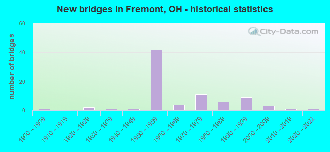
- New bridges - historical statistics
- 11900-1909
- 21920-1929
- 11930-1939
- 11940-1949
- 421950-1959
- 41960-1969
- 111970-1979
- 61980-1989
- 91990-1999
- 32000-2009
- 12010-2019
- 12020-2022

- Reconstructed bridges - Historical Statistics
- 41970-1979
- 61980-1989
- 91990-1999
- 72000-2009


- Bridge Condition - Deck
- 4.8%Excellent
- 30.6%Very good
- 45.2%Good
- 16.1%Satisfactory
- 3.2%Fair

- Bridge Condition - Superstructure
- 1.6%Excellent
- 27.0%Very good
- 55.6%Good
- 9.5%Satisfactory
- 4.8%Fair
- 1.6%Poor

- Bridge Condition - Substructure
- 31.7%Very good
- 46.0%Good
- 20.6%Satisfactory
- 1.6%Fair

- Bridge Condition - Channel
- 12.5%Very good
- 43.8%Good
- 37.5%Satisfactory
- 6.3%Fair

- Bridge Condition - Culverts
- 50.0%Very good
- 50.0%Satisfactory
Find on map >> Show street view
Structure Number: 720042, Location: MUSKELLUNGE CR & TP RD 57 (Lat: 41.368600, Lng: -83.148969), Route carried "on" structure: US 6, Year Built: 1957, Year Reconstructed: 2006, Status: Open, Structure Length: 6.04m (19.82ft), Average Daily Traffic: 7,427 (year 2015), Truck Traffic: 21%, Average Future Daily Traffic: 10,309 (year 2035), Design Load: HS 20, Features Intersected: MUSKELLUNGE CR & TR 57
Minimum Vertical Clearance: 30+ m (98+ ft), Kilometerpoint: 24.752, Lanes on structure: 2, Lanes under structure: 2, Base Highway Network: Yes, Owner: State Highway Agency, Approaching Roadway Width: 11.6m (38.1ft), Material/Design: Steel continuous, Design/Construction: Stringer/Multi-beam, Number Of Spans In Main Unit: 3, Length of Maximum Span: 22.9m (75.1ft), Curb-To-Curb Width: 12.8m (42.0ft), Out-to-Out Width: 13.7m (44.9ft)
Condition: Deck: Good, Superstructure: Good, Substructure: Good, Channel: Good, Operating Rating: 32.4 metric tons, Method Used To Determine Operating Rating: Load and Resistance Factor Rating (LRFR) rating reported by rating factor(RF) method using HL-93 loadings, Inventory Rating: 25.9 metric tons, Method Used To Determine Inventory Rating: Load and Resistance Factor Rating (LRFR) rating reported by rating factor(RF) method using HL-93 loadings, Structural Evaluation: Equal to present minimum criteria, Deck Geometry: Equal to present desirable criteria, Underclear: High priority of corrective action, Waterway Adequacy: Superior to present desirable criteria, Approach Roadway Alignment: Equal to present desirable criteria, Designated Inspection Frequency: Every 24 months, Inspection Date: November 2021, Deck Structure Type: Concrete Cast-file-Place, Wearing Surface/Protective System: Wearing Surface: Monolithic Concrete, Deck Protection: Epoxy Coated Reinforcing
Find on map >> Show street view
Structure Number: 7200455, Location: MUSKELLUNGE CR & TP RD 57 (Lat: 41.368439, Lng: -83.148981), Route carried "on" structure: US 6, Year Built: 1957, Year Reconstructed: 2006, Status: Open, Structure Length: 6.04m (19.82ft), Average Daily Traffic: 7,427 (year 2015), Truck Traffic: 21%, Average Future Daily Traffic: 10,309 (year 2035), Design Load: HS 20, Features Intersected: MUSKELLUNGE CR & TR 57
Minimum Vertical Clearance: 30+ m (98+ ft), Kilometerpoint: 24.752, Lanes on structure: 2, Lanes under structure: 2, Base Highway Network: Yes, Owner: State Highway Agency, Approaching Roadway Width: 11.6m (38.1ft), Material/Design: Steel continuous, Design/Construction: Stringer/Multi-beam, Number Of Spans In Main Unit: 3, Length of Maximum Span: 22.9m (75.1ft), Curb-To-Curb Width: 12.8m (42.0ft), Out-to-Out Width: 13.7m (44.9ft)
Condition: Deck: Good, Superstructure: Good, Substructure: Good, Channel: Good, Operating Rating: 32.4 metric tons, Method Used To Determine Operating Rating: Load and Resistance Factor Rating (LRFR) rating reported by rating factor(RF) method using HL-93 loadings, Inventory Rating: 25.9 metric tons, Method Used To Determine Inventory Rating: Load and Resistance Factor Rating (LRFR) rating reported by rating factor(RF) method using HL-93 loadings, Structural Evaluation: Equal to present minimum criteria, Deck Geometry: Equal to present desirable criteria, Underclear: High priority of corrective action, Waterway Adequacy: Superior to present desirable criteria, Approach Roadway Alignment: Equal to present desirable criteria, Designated Inspection Frequency: Every 24 months, Inspection Date: November 2021, Deck Structure Type: Concrete Cast-file-Place, Wearing Surface/Protective System: Wearing Surface: Monolithic Concrete, Deck Protection: Epoxy Coated Reinforcing
Find on map >> Show street view
Structure Number: 7200579, Location: JCT U.S. 6/SAND. RIVER (Lat: 41.367381, Lng: -83.108481), Route carried "on" structure: US 6, Year Built: 1957, Year Reconstructed: 1997, Status: Open, Structure Length: 24.54m (80.51ft), Average Daily Traffic: 23,377 (year 2015), Truck Traffic: 19%, Average Future Daily Traffic: 32,447 (year 2035), Design Load: HS 20, Features Intersected: SAND.RIV, NS RR, CR 53
Minimum Vertical Clearance: 30+ m (98+ ft), Kilometerpoint: 28.180, Lanes on structure: 4, Lanes under structure: 2, Base Highway Network: Yes, Owner: State Highway Agency, Approaching Roadway Width: 9.8m (32.2ft), Skew: 30 degrees, Navigation Control: Yes ( Vertical Clearance: 15.2m (49.9ft), Horizontal Clearance: 40.8m (133.9ft)), Material/Design: Steel continuous, Design/Construction: Stringer/Multi-beam, Number Of Spans In Main Unit: 8, Length of Maximum Span: 42.7m (140.1ft), Curb-To-Curb Width: 19.5m (64.0ft), Out-to-Out Width: 21.5m (70.5ft)
Condition: Deck: Good, Superstructure: Good, Substructure: Satisfactory, Channel: Satisfactory, Operating Rating: 25.9 metric tons, Method Used To Determine Operating Rating: Allowable Stress (AS) rating reported by rating factor (RF) method using MS18 loading, Inventory Rating: 19.4 metric tons, Method Used To Determine Inventory Rating: Allowable Stress (AS) rating reported by rating factor (RF) method using MS18 loading, Structural Evaluation: Meets minimum limits, Deck Geometry: Somewhat better than minimum adequacy, Underclear: Meets minimum limits, Waterway Adequacy: Superior to present desirable criteria, Approach Roadway Alignment: Equal to present desirable criteria, Designated Inspection Frequency: Every 12 months, Underwater Inspection Frequency: Every 60 months, Inspection Date: September 2021, Underwater Inspection Date: May 2020, Deck Structure Type: Concrete Cast-file-Place, Wearing Surface/Protective System: Wearing Surface: Monolithic Concrete, Deck Protection: Epoxy Coated Reinforcing
Find on map >> Show street view
Structure Number: 7200625, Location: 0.64 MILES WEST OF SR 412 (Lat: 41.362931, Lng: -83.085789), Route carried "on" structure: US 6, Year Built: 1993, Status: Open, Structure Length: 6.89m (22.60ft), Average Daily Traffic: 6,251 (year 2015), Truck Traffic: 17%, Average Future Daily Traffic: 8,676 (year 2035), Design Load: HS 20+Mod, Features Intersected: USR 20/SR 19
Minimum Vertical Clearance: 30+ m (98+ ft), Kilometerpoint: 30.304, Lanes on structure: 2, Lanes under structure: 4, Base Highway Network: Yes, Owner: State Highway Agency, Approaching Roadway Width: 17.1m (56.1ft), Skew: 1 degrees, Material/Design: Steel continuous, Design/Construction: Stringer/Multi-beam, Number Of Spans In Main Unit: 2, Length of Maximum Span: 35.7m (117.1ft), Curb-To-Curb Width: 18.3m (60.0ft), Out-to-Out Width: 19.2m (63.0ft)
Condition: Deck: Good, Superstructure: Good, Substructure: Good, Operating Rating: 32.4 metric tons, Method Used To Determine Operating Rating: Allowable Stress (AS) rating reported by rating factor (RF) method using MS18 loading, Inventory Rating: 25.9 metric tons, Method Used To Determine Inventory Rating: Allowable Stress (AS) rating reported by rating factor (RF) method using MS18 loading, Structural Evaluation: Equal to present minimum criteria, Deck Geometry: Superior to present desirable criteria, Underclear: Somewhat better than minimum adequacy, Approach Roadway Alignment: Equal to present minimum criteria, Designated Inspection Frequency: Every 24 months, Inspection Date: November 2021, Deck Structure Type: Concrete Cast-file-Place, Wearing Surface/Protective System: Wearing Surface: Monolithic Concrete, Deck Protection: Epoxy Coated Reinforcing
Find on map >> Show street view
Structure Number: 7200676, Location: 3/4 MI. N. OF US 20 (Lat: 41.368769, Lng: -83.075431), Route carried "on" structure: US 6, Year Built: 1991, Status: Open, Structure Length: 1.59m (5.22ft), Average Daily Traffic: 6,251 (year 2015), Truck Traffic: 17%, Average Future Daily Traffic: 8,676 (year 2035), Design Load: HS 20+Mod, Features Intersected: BARK CREEK
Minimum Vertical Clearance: 30+ m (98+ ft), Kilometerpoint: 31.511, Lanes on structure: 2, Owner: State Highway Agency, Approaching Roadway Width: 9.1m (29.9ft), Skew: 2 degrees, Material/Design: Prestressed concrete, Design/Construction: Box Beam or Girders - Multiple, Number Of Spans In Main Unit: 1, Length of Maximum Span: 15.5m (50.9ft), Curb-To-Curb Width: 13.4m (44.0ft), Out-to-Out Width: 13.4m (44.0ft)
Condition: Deck: Good, Superstructure: Very good, Substructure: Good, Channel: Satisfactory, Operating Rating: 48.6 metric tons, Method Used To Determine Operating Rating: Load and Resistance Factor Rating (LRFR) rating reported by rating factor(RF) method using HL-93 loadings, Inventory Rating: 29.2 metric tons, Method Used To Determine Inventory Rating: Load and Resistance Factor Rating (LRFR) rating reported by rating factor(RF) method using HL-93 loadings, Structural Evaluation: Better than present minimum criteria, Deck Geometry: Equal to present minimum criteria, Waterway Adequacy: Superior to present desirable criteria, Approach Roadway Alignment: Better than present minimum criteria, Designated Inspection Frequency: Every 24 months, Inspection Date: November 2021, Deck Structure Type: Concrete Cast-file-Place, Wearing Surface/Protective System: Wearing Surface: Bituminous
Find on map >> Show street view
Structure Number: 7201109, Location: 2.76 mi. South of IR 80 (Lat: 41.368069, Lng: -83.134689), Route carried "on" structure: State highway 19, Year Built: 1970, Status: Open, Structure Length: 6.83m (22.41ft), Average Daily Traffic: 2,703 (year 2015), Truck Traffic: 7%, Average Future Daily Traffic: 3,752 (year 2035), Design Load: H 20, Features Intersected: USR 6
Minimum Vertical Clearance: 30+ m (98+ ft), Kilometerpoint: 17.365, Lanes on structure: 4, Lanes under structure: 4, Owner: State Highway Agency, Approaching Roadway Width: 21.9m (71.9ft), Skew: 20 degrees, Material/Design: Steel continuous, Design/Construction: Stringer/Multi-beam, Number Of Spans In Main Unit: 4, Length of Maximum Span: 21.9m (71.9ft), Curb-To-Curb Width: 21.6m (70.9ft), Out-to-Out Width: 23.0m (75.5ft)
Condition: Deck: Satisfactory, Superstructure: Satisfactory, Substructure: Satisfactory, Operating Rating: 42.1 metric tons, Method Used To Determine Operating Rating: Allowable Stress (AS) rating reported by rating factor (RF) method using MS18 loading, Inventory Rating: 32.4 metric tons, Method Used To Determine Inventory Rating: Allowable Stress (AS) rating reported by rating factor (RF) method using MS18 loading, Structural Evaluation: Equal to present minimum criteria, Deck Geometry: Superior to present desirable criteria, Underclear: High priority of corrective action, Approach Roadway Alignment: Superior to present desirable criteria, Designated Inspection Frequency: Every 12 months, Inspection Date: May 2021, Deck Structure Type: Concrete Cast-file-Place, Wearing Surface/Protective System: Wearing Surface: Latex Concrete
Find on map >> Show street view
Structure Number: 7201117, Location: 1.71 mi. South of IR 80 (Lat: 41.382850, Lng: -83.136439), Route carried "on" structure: State highway 19, Year Built: 1947, Status: Open, Structure Length: 2.83m (9.28ft), Average Daily Traffic: 4,376 (year 2015), Truck Traffic: 7%, Average Future Daily Traffic: 6,074 (year 2035), Design Load: H 15, Features Intersected: MUSKELLUNGE CREEK
Minimum Vertical Clearance: 30+ m (98+ ft), Kilometerpoint: 19.055, Lanes on structure: 2, Owner: State Highway Agency, Approaching Roadway Width: 9.8m (32.2ft), Skew: 1 degrees, Material/Design: Concrete continuous, Design/Construction: Slab, Number Of Spans In Main Unit: 3, Length of Maximum Span: 10.7m (35.1ft), Curb-To-Curb Width: 9.8m (32.2ft), Out-to-Out Width: 9.9m (32.5ft)
Condition: Deck: Good, Superstructure: Good, Substructure: Satisfactory, Channel: Satisfactory, Operating Rating: 42.1 metric tons, Method Used To Determine Operating Rating: Allowable Stress (AS) rating reported by rating factor (RF) method using MS18 loading, Inventory Rating: 32.4 metric tons, Method Used To Determine Inventory Rating: Allowable Stress (AS) rating reported by rating factor (RF) method using MS18 loading, Structural Evaluation: Equal to present minimum criteria, Deck Geometry: Meets minimum limits, Waterway Adequacy: Better than present minimum criteria, Approach Roadway Alignment: Better than present minimum criteria, Designated Inspection Frequency: Every 12 months, Inspection Date: May 2021, Deck Structure Type: Concrete Cast-file-Place, Wearing Surface/Protective System: Wearing Surface: Bituminous
Find on map >> Show street view
Structure Number: 7201206, Location: 0.15 mi. North of IR 80 (Lat: 41.409731, Lng: -83.135669), Route carried "on" structure: State highway 19, Year Built: 1900, Year Reconstructed: 1983, Status: Open, Structure Length: 1.01m (3.31ft), Average Daily Traffic: 3,710 (year 2015), Truck Traffic: 7%, Average Future Daily Traffic: 5,149 (year 2035), Design Load: HS 20+Mod, Features Intersected: LITTLE MUDDY CREEK
Minimum Vertical Clearance: 30+ m (98+ ft), Kilometerpoint: 22.048, Lanes on structure: 2, Owner: State Highway Agency, Approaching Roadway Width: 7.3m (24.0ft), Material/Design: Prestressed concrete, Design/Construction: Box Beam or Girders - Multiple, Number Of Spans In Main Unit: 1, Length of Maximum Span: 9.4m (30.8ft), Curb-To-Curb Width: 8.6m (28.2ft), Out-to-Out Width: 8.6m (28.2ft)
Condition: Deck: Good, Superstructure: Good, Substructure: Satisfactory, Channel: Fair, Operating Rating: 42.1 metric tons, Method Used To Determine Operating Rating: Load Factor (LF) rating reported by rating factor (RF) method using MS18 loading, Inventory Rating: 32.4 metric tons, Method Used To Determine Inventory Rating: Load Factor (LF) rating reported by rating factor (RF) method using MS18 loading, Structural Evaluation: Equal to present minimum criteria, Deck Geometry: Meets minimum limits, Waterway Adequacy: Equal to present desirable criteria, Approach Roadway Alignment: Equal to present desirable criteria, Designated Inspection Frequency: Every 12 months, Inspection Date: May 2021, Deck Structure Type: Concrete Cast-file-Place, Wearing Surface/Protective System: Wearing Surface: Bituminous
Find on map >> Show street view
Structure Number: 7201249, Location: 1.77 mi. North of IR80 (Lat: 41.433139, Lng: -83.135250), Route carried "on" structure: State highway 19, Year Built: 1984, Status: Open, Structure Length: 1.13m (3.71ft), Average Daily Traffic: 3,710 (year 2015), Truck Traffic: 7%, Average Future Daily Traffic: 5,149 (year 2035), Design Load: HS 20+Mod, Features Intersected: FISHING CREEK
Minimum Vertical Clearance: 30+ m (98+ ft), Kilometerpoint: 24.639, Lanes on structure: 2, Owner: State Highway Agency, Approaching Roadway Width: 7.3m (24.0ft), Material/Design: Prestressed concrete, Design/Construction: Box Beam or Girders - Multiple, Number Of Spans In Main Unit: 1, Length of Maximum Span: 11.0m (36.1ft), Curb-To-Curb Width: 9.2m (30.2ft), Out-to-Out Width: 9.2m (30.2ft)
Condition: Deck: Fair, Superstructure: Fair, Substructure: Good, Channel: Fair, Operating Rating: 42.1 metric tons, Method Used To Determine Operating Rating: Load Factor (LF) rating reported by rating factor (RF) method using MS18 loading, Inventory Rating: 32.4 metric tons, Method Used To Determine Inventory Rating: Load Factor (LF) rating reported by rating factor (RF) method using MS18 loading, Structural Evaluation: Somewhat better than minimum adequacy, Deck Geometry: Meets minimum limits, Waterway Adequacy: Equal to present desirable criteria, Approach Roadway Alignment: Equal to present desirable criteria, Designated Inspection Frequency: Every 12 months, Inspection Date: May 2021, Deck Structure Type: Concrete Cast-file-Place, Wearing Surface/Protective System: Wearing Surface: Bituminous, Membrane: Preformed Fabric
Find on map >> Show street view
Structure Number: 7201893, Location: 0.24 mi. East of USR 6 (Lat: 41.360689, Lng: -83.082500), Route carried "on" structure: US 20, Year Built: 1957, Status: Open, Structure Length: 3.23m (10.60ft), Average Daily Traffic: 8,556 (year 2018), Truck Traffic: 13%, Average Future Daily Traffic: 11,058 (year 2038), Design Load: H 20, Features Intersected: BARK CREEK
Minimum Vertical Clearance: 30+ m (98+ ft), Kilometerpoint: 30.899, Lanes on structure: 2, Base Highway Network: Yes, Owner: State Highway Agency, Approaching Roadway Width: 13.4m (44.0ft), Material/Design: Concrete continuous, Design/Construction: Slab, Number Of Spans In Main Unit: 3, Length of Maximum Span: 12.2m (40.0ft), Curb-To-Curb Width: 13.4m (44.0ft), Out-to-Out Width: 13.4m (44.0ft)
Condition: Deck: Good, Superstructure: Good, Substructure: Satisfactory, Channel: Good, Operating Rating: 42.1 metric tons, Method Used To Determine Operating Rating: Load and Resistance Factor Rating (LRFR) rating reported by rating factor(RF) method using HL-93 loadings, Inventory Rating: 32.4 metric tons, Method Used To Determine Inventory Rating: Load and Resistance Factor Rating (LRFR) rating reported by rating factor(RF) method using HL-93 loadings, Structural Evaluation: Equal to present minimum criteria, Deck Geometry: Superior to present desirable criteria, Waterway Adequacy: Equal to present minimum criteria, Approach Roadway Alignment: Equal to present desirable criteria, Designated Inspection Frequency: Every 12 months, Inspection Date: June 2021, Deck Structure Type: Concrete Cast-file-Place, Wearing Surface/Protective System: Wearing Surface: Integral Concrete
Find on map >> Show street view
Structure Number: 7201923, Location: 0.24 mi. East of USR 6 (Lat: 41.360581, Lng: -83.082669), Route carried "on" structure: US 20, Year Built: 1957, Status: Open, Structure Length: 3.23m (10.60ft), Average Daily Traffic: 8,556 (year 2018), Truck Traffic: 13%, Average Future Daily Traffic: 11,058 (year 2038), Design Load: H 20, Features Intersected: BARK CREEK
Minimum Vertical Clearance: 30+ m (98+ ft), Kilometerpoint: 30.899, Lanes on structure: 2, Base Highway Network: Yes, Owner: State Highway Agency, Approaching Roadway Width: 13.4m (44.0ft), Material/Design: Concrete continuous, Design/Construction: Slab, Number Of Spans In Main Unit: 3, Length of Maximum Span: 12.2m (40.0ft), Curb-To-Curb Width: 13.4m (44.0ft), Out-to-Out Width: 13.4m (44.0ft)
Condition: Deck: Good, Superstructure: Good, Substructure: Satisfactory, Channel: Good, Operating Rating: 42.1 metric tons, Method Used To Determine Operating Rating: Load and Resistance Factor Rating (LRFR) rating reported by rating factor(RF) method using HL-93 loadings, Inventory Rating: 32.4 metric tons, Method Used To Determine Inventory Rating: Load and Resistance Factor Rating (LRFR) rating reported by rating factor(RF) method using HL-93 loadings, Structural Evaluation: Equal to present minimum criteria, Deck Geometry: Superior to present desirable criteria, Waterway Adequacy: Equal to present minimum criteria, Approach Roadway Alignment: Equal to present desirable criteria, Designated Inspection Frequency: Every 12 months, Inspection Date: June 2021, Deck Structure Type: Concrete Cast-file-Place, Wearing Surface/Protective System: Wearing Surface: Integral Concrete, Membrane: Built-up
Find on map >> Show street view
Structure Number: 7202016, Location: 0.86 mi. West of SR 19 (Lat: 41.334669, Lng: -83.062311), Route carried "on" structure: County highway C0020, Year Built: 1958, Year Reconstructed: 2008, Status: Open, Structure Length: 6.07m (19.91ft), Average Daily Traffic: 3,359 (year 2015), Truck Traffic: 3%, Average Future Daily Traffic: 10,436 (year 2035), Design Load: HS 20, Features Intersected: USR 20 & SR 19, Facility Carried by Structure: CR 20
Minimum Vertical Clearance: 30+ m (98+ ft), Kilometerpoint: 8.755, Lanes on structure: 2, Lanes under structure: 1, Owner: State Highway Agency, Approaching Roadway Width: 9.1m (29.9ft), Material/Design: Steel continuous, Design/Construction: Stringer/Multi-beam, Number Of Spans In Main Unit: 3, Length of Maximum Span: 21.3m (69.9ft), Curb-To-Curb Width: 9.1m (29.9ft), Out-to-Out Width: 11.2m (36.7ft)
Condition: Deck: Good, Superstructure: Good, Substructure: Good, Operating Rating: 42.1 metric tons, Method Used To Determine Operating Rating: Load Factor (LF) rating reported by rating factor (RF) method using MS18 loading, Inventory Rating: 32.4 metric tons, Method Used To Determine Inventory Rating: Load Factor (LF) rating reported by rating factor (RF) method using MS18 loading, Structural Evaluation: Better than present minimum criteria, Deck Geometry: Meets minimum limits, Underclear: Equal to present minimum criteria, Approach Roadway Alignment: Superior to present desirable criteria, Designated Inspection Frequency: Every 24 months, Inspection Date: November 2021, Deck Structure Type: Concrete Cast-file-Place, Wearing Surface/Protective System: Wearing Surface: Monolithic Concrete, Deck Protection: Epoxy Coated Reinforcing
Find on map >> Show street view
Structure Number: 720204, Location: 0.47 mi. West of SR19 (Lat: 41.331789, Lng: -83.055819), Route carried "on" structure: US 20, Year Built: 1951, Year Reconstructed: 1995, Status: Open, Structure Length: 4.05m (13.29ft), Average Daily Traffic: 20,759 (year 2018), Truck Traffic: 14%, Average Future Daily Traffic: 28,813 (year 2038), Design Load: H 20, Features Intersected: GREEN CREEK
Minimum Vertical Clearance: 30+ m (98+ ft), Kilometerpoint: 34.923, Lanes on structure: 4, Base Highway Network: Yes, Owner: State Highway Agency, Approaching Roadway Width: 23.8m (78.1ft), Skew: 3 degrees, Material/Design: Steel continuous, Design/Construction: Stringer/Multi-beam, Number Of Spans In Main Unit: 3, Length of Maximum Span: 15.2m (49.9ft), Curb-To-Curb Width: 26.8m (87.9ft), Out-to-Out Width: 26.9m (88.3ft)
Condition: Deck: Good, Superstructure: Satisfactory, Substructure: Satisfactory, Channel: Satisfactory, Operating Rating: 42.1 metric tons, Method Used To Determine Operating Rating: Allowable Stress (AS) rating reported by rating factor (RF) method using MS18 loading, Inventory Rating: 32.4 metric tons, Method Used To Determine Inventory Rating: Allowable Stress (AS) rating reported by rating factor (RF) method using MS18 loading, Structural Evaluation: Equal to present minimum criteria, Deck Geometry: Superior to present desirable criteria, Waterway Adequacy: Equal to present minimum criteria, Approach Roadway Alignment: Equal to present desirable criteria, Designated Inspection Frequency: Every 12 months, Inspection Date: June 2021, Deck Structure Type: Concrete Cast-file-Place, Wearing Surface/Protective System: Wearing Surface: Monolithic Concrete, Deck Protection: Epoxy Coated Reinforcing
Find on map >> Show street view
Structure Number: 7202253, Location: 0.92 mi. East of SR 19 (Lat: 41.367339, Lng: -83.117119), Route carried "on" structure: State highway 53, Year Built: 1956, Year Reconstructed: 2007, Status: Open, Structure Length: 7.59m (24.90ft), Average Daily Traffic: 11,393 (year 2015), Truck Traffic: 13%, Average Future Daily Traffic: 15,813 (year 2035), Design Load: HS 20, Features Intersected: USR 6
Minimum Vertical Clearance: 30+ m (98+ ft), Kilometerpoint: 17.123, Lanes on structure: 4, Lanes under structure: 4, Base Highway Network: Yes, Owner: State Highway Agency, Approaching Roadway Width: 21.9m (71.9ft), Material/Design: Steel continuous, Design/Construction: Stringer/Multi-beam, Number Of Spans In Main Unit: 4, Length of Maximum Span: 20.7m (67.9ft), Curb-To-Curb Width: 21.9m (71.9ft), Out-to-Out Width: 22.9m (75.1ft)
Condition: Deck: Good, Superstructure: Good, Substructure: Good, Operating Rating: 42.1 metric tons, Method Used To Determine Operating Rating: Allowable Stress (AS) rating reported by rating factor (RF) method using MS18 loading, Inventory Rating: 32.4 metric tons, Method Used To Determine Inventory Rating: Allowable Stress (AS) rating reported by rating factor (RF) method using MS18 loading, Structural Evaluation: Better than present minimum criteria, Deck Geometry: Superior to present desirable criteria, Underclear: Equal to present minimum criteria, Approach Roadway Alignment: Superior to present desirable criteria, Designated Inspection Frequency: Every 24 months, Inspection Date: November 2021, Deck Structure Type: Concrete Cast-file-Place, Wearing Surface/Protective System: Wearing Surface: Monolithic Concrete, Deck Protection: Epoxy Coated Reinforcing
Find on map >> Show street view
Structure Number: 7202288, Location: 1 Mi. N. of USR 6 (Lat: 41.383531, Lng: -83.115789), Route carried "on" structure: State highway 53, Year Built: 1956, Year Reconstructed: 2007, Status: Open, Structure Length: 6.07m (19.91ft), Average Daily Traffic: 11,393 (year 2015), Truck Traffic: 9%, Average Future Daily Traffic: 15,813 (year 2035), Design Load: HS 20, Features Intersected: NORFOLK SOUTHERN RR
Minimum Vertical Clearance: 30+ m (98+ ft), Kilometerpoint: 18.926, Lanes on structure: 4, Owner: State Highway Agency, Approaching Roadway Width: 24.4m (80.1ft), Skew: 4 degrees, Material/Design: Steel continuous, Design/Construction: Stringer/Multi-beam, Number Of Spans In Main Unit: 3, Length of Maximum Span: 22.9m (75.1ft), Curb-To-Curb Width: 25.6m (84.0ft), Out-to-Out Width: 26.8m (87.9ft)
Condition: Deck: Very good, Superstructure: Good, Substructure: Good, Operating Rating: 42.1 metric tons, Method Used To Determine Operating Rating: Allowable Stress (AS) rating reported by rating factor (RF) method using MS18 loading, Inventory Rating: 32.4 metric tons, Method Used To Determine Inventory Rating: Allowable Stress (AS) rating reported by rating factor (RF) method using MS18 loading, Structural Evaluation: Better than present minimum criteria, Deck Geometry: Superior to present desirable criteria, Underclear: Equal to present minimum criteria, Approach Roadway Alignment: Superior to present desirable criteria, Designated Inspection Frequency: Every 24 months, Inspection Date: November 2021, Deck Structure Type: Concrete Cast-file-Place, Wearing Surface/Protective System: Wearing Surface: Monolithic Concrete, Deck Protection: Epoxy Coated Reinforcing
Find on map >> Show street view
Structure Number: 7202318, Location: 1.95 mi. North of USR 20 (Lat: 41.395019, Lng: -83.109750), Route carried "on" structure: State highway 53, Year Built: 1956, Year Reconstructed: 2007, Status: Open, Structure Length: 4.85m (15.91ft), Average Daily Traffic: 11,393 (year 2015), Truck Traffic: 9%, Average Future Daily Traffic: 15,813 (year 2035), Design Load: HS 20, Features Intersected: MUSKELLUNGE CREEK
Minimum Vertical Clearance: 30+ m (98+ ft), Kilometerpoint: 20.262, Lanes on structure: 4, Base Highway Network: Yes, Owner: State Highway Agency, Approaching Roadway Width: 24.4m (80.1ft), Skew: 1 degrees, Material/Design: Steel continuous, Design/Construction: Stringer/Multi-beam, Number Of Spans In Main Unit: 3, Length of Maximum Span: 18.3m (60.0ft), Curb-To-Curb Width: 25.6m (84.0ft), Out-to-Out Width: 25.6m (84.0ft)
Condition: Deck: Very good, Superstructure: Good, Substructure: Good, Channel: Good, Operating Rating: 42.1 metric tons, Method Used To Determine Operating Rating: Allowable Stress (AS) rating reported by rating factor (RF) method using MS18 loading, Inventory Rating: 32.4 metric tons, Method Used To Determine Inventory Rating: Allowable Stress (AS) rating reported by rating factor (RF) method using MS18 loading, Structural Evaluation: Better than present minimum criteria, Deck Geometry: Superior to present desirable criteria, Waterway Adequacy: Superior to present desirable criteria, Approach Roadway Alignment: Superior to present desirable criteria, Designated Inspection Frequency: Every 24 months, Inspection Date: November 2021, Deck Structure Type: Concrete Cast-file-Place, Wearing Surface/Protective System: Wearing Surface: Monolithic Concrete, Deck Protection: Epoxy Coated Reinforcing
Find on map >> Show street view
Structure Number: 7202407, Location: 0.3 EAST OF EXIT 91 (Lat: 41.401711, Lng: -83.104350), Route carried "on" structure: Ramp State highway 53, Year Built: 1954, Year Reconstructed: 1984, Status: Open, Structure Length: 4.60m (15.09ft), Average Daily Traffic: 1,838 (year 2019), Truck Traffic: 25%, Average Future Daily Traffic: 10,013 (year 2039), Design Load: HS 20+Mod, Features Intersected: SR 53, Facility Carried by Structure: TPK EXIT 91 RAMP
Minimum Vertical Clearance: 9.14m (29.99ft), Kilometerpoint: 21.147, Lanes on structure: 2, Lanes under structure: 4, Owner: State Toll Authority, Approaching Roadway Width: 11.0m (36.1ft), Skew: 22 degrees, Material/Design: Steel, Design/Construction: Stringer/Multi-beam, Number Of Spans In Main Unit: 3, Length of Maximum Span: 26.8m (87.9ft), Curb-To-Curb Width: 9.4m (30.8ft), Out-to-Out Width: 10.4m (34.1ft)
Condition: Deck: Satisfactory, Superstructure: Good, Substructure: Fair, Operating Rating: 64.8 metric tons, Method Used To Determine Operating Rating: Load Factor (LF) rating reported by rating factor (RF) method using MS18 loading, Inventory Rating: 38.9 metric tons, Method Used To Determine Inventory Rating: Load Factor (LF) rating reported by rating factor (RF) method using MS18 loading, Structural Evaluation: Somewhat better than minimum adequacy, Deck Geometry: Somewhat better than minimum adequacy, Underclear: High priority of corrective action, Approach Roadway Alignment: Equal to present desirable criteria, Designated Inspection Frequency: Every 12 months, Inspection Date: March 2021, Deck Structure Type: Concrete Cast-file-Place, Wearing Surface/Protective System: Wearing Surface: Monolithic Concrete, Deck Protection: Epoxy Coated Reinforcing
Find on map >> Show street view
Structure Number: 7202679, Location: JCT. USR 20 (Lat: 41.356200, Lng: -83.076619), Route carried "on" structure: State highway 412, Year Built: 1958, Year Reconstructed: 2008, Status: Open, Structure Length: 6.58m (21.59ft), Average Daily Traffic: 1,095 (year 2015), Truck Traffic: 9%, Average Future Daily Traffic: 1,520 (year 2035), Design Load: H 15, Features Intersected: USR 20
Minimum Vertical Clearance: 30+ m (98+ ft), Kilometerpoint: 0.354, Lanes on structure: 2, Lanes under structure: 4, Owner: State Highway Agency, Approaching Roadway Width: 7.9m (25.9ft), Skew: 2 degrees, Material/Design: Steel continuous, Design/Construction: Stringer/Multi-beam, Number Of Spans In Main Unit: 4, Length of Maximum Span: 19.2m (63.0ft), Curb-To-Curb Width: 9.8m (32.2ft), Out-to-Out Width: 10.7m (35.1ft)
Condition: Deck: Very good, Superstructure: Good, Substructure: Good, Operating Rating: 42.1 metric tons, Method Used To Determine Operating Rating: Load Factor (LF) rating reported by rating factor (RF) method using MS18 loading, Inventory Rating: 32.4 metric tons, Method Used To Determine Inventory Rating: Load Factor (LF) rating reported by rating factor (RF) method using MS18 loading, Structural Evaluation: Better than present minimum criteria, Deck Geometry: Somewhat better than minimum adequacy, Underclear: Somewhat better than minimum adequacy, Approach Roadway Alignment: Superior to present desirable criteria, Designated Inspection Frequency: Every 24 months, Inspection Date: November 2021, Deck Structure Type: Concrete Cast-file-Place, Wearing Surface/Protective System: Wearing Surface: Monolithic Concrete, Deck Protection: Epoxy Coated Reinforcing
Find on map >> Show street view
Structure Number: 7202695, Location: 1.15 mi. North of USR 20 (Lat: 41.359939, Lng: -83.055589), Route carried "on" structure: State highway 412, Year Built: 1983, Status: Open, Structure Length: 3.26m (10.70ft), Average Daily Traffic: 1,095 (year 2015), Truck Traffic: 9%, Average Future Daily Traffic: 1,520 (year 2035), Design Load: HS 20+Mod, Features Intersected: GREEN CREEK
Minimum Vertical Clearance: 30+ m (98+ ft), Kilometerpoint: 2.205, Lanes on structure: 2, Owner: State Highway Agency, Approaching Roadway Width: 8.5m (27.9ft), Material/Design: Concrete continuous, Design/Construction: Slab, Number Of Spans In Main Unit: 3, Length of Maximum Span: 12.2m (40.0ft), Curb-To-Curb Width: 12.2m (40.0ft), Out-to-Out Width: 12.8m (42.0ft)
Condition: Deck: Good, Superstructure: Good, Substructure: Good, Channel: Satisfactory, Operating Rating: 42.1 metric tons, Method Used To Determine Operating Rating: Allowable Stress (AS) rating reported by rating factor (RF) method using MS18 loading, Inventory Rating: 32.4 metric tons, Method Used To Determine Inventory Rating: Allowable Stress (AS) rating reported by rating factor (RF) method using MS18 loading, Structural Evaluation: Better than present minimum criteria, Deck Geometry: Better than present minimum criteria, Waterway Adequacy: Equal to present desirable criteria, Approach Roadway Alignment: Equal to present desirable criteria, Designated Inspection Frequency: Every 24 months, Inspection Date: November 2021, Deck Structure Type: Concrete Cast-file-Place, Wearing Surface/Protective System: Wearing Surface: Integral Concrete, Deck Protection: Other
Find on map >> Show street view
Structure Number: 7202741, Location: JCT TWP RD 220 (Lat: 41.363669, Lng: -83.031400), Route carried "on" structure: State highway 412, Year Built: 2002, Status: Open, Structure Length: 0.85m (2.79ft), Average Daily Traffic: 1,095 (year 2015), Truck Traffic: 9%, Average Future Daily Traffic: 1,520 (year 2035), Design Load: HS 25 or greater, Features Intersected: SOUTH CREEK BRANCH
Minimum Vertical Clearance: 30+ m (98+ ft), Kilometerpoint: 4.297, Lanes on structure: 2, Owner: State Highway Agency, Approaching Roadway Width: 7.9m (25.9ft), Skew: 3 degrees, Material/Design: Concrete, Design/Construction: Slab, Number Of Spans In Main Unit: 1, Length of Maximum Span: 7.9m (25.9ft), Curb-To-Curb Width: 7.9m (25.9ft), Out-to-Out Width: 8.5m (27.9ft)
Condition: Deck: Very good, Superstructure: Very good, Substructure: Very good, Channel: Satisfactory, Operating Rating: 81.0 metric tons, Method Used To Determine Operating Rating: Load and Resistance Factor Rating (LRFR) rating reported by rating factor(RF) method using HL-93 loadings, Inventory Rating: 77.8 metric tons, Method Used To Determine Inventory Rating: Load and Resistance Factor Rating (LRFR) rating reported by rating factor(RF) method using HL-93 loadings, Structural Evaluation: Equal to present desirable criteria, Deck Geometry: Meets minimum limits, Waterway Adequacy: Equal to present desirable criteria, Approach Roadway Alignment: Equal to present desirable criteria, Designated Inspection Frequency: Every 24 months, Inspection Date: November 2021, Deck Structure Type: Concrete Cast-file-Place, Wearing Surface/Protective System: Wearing Surface: Bituminous
Find on map >> Show street view
Structure Number: 7228872, Location: 2.2MI WEST OF EXIT 91 (Lat: 41.414850, Lng: -83.151919), Route carried "on" structure: County highway C0109, Year Built: 1955, Year Reconstructed: 1997, Status: Open, Structure Length: 11.73m (38.48ft), Average Daily Traffic: 400 (year 1996), Truck Traffic: 10%, Average Future Daily Traffic: 60,327 (year 2016), Design Load: HS 20+Mod, Features Intersected: I80 OHIO TURNPIKE, Facility Carried by Structure: KINGSWAY RD
Minimum Vertical Clearance: 30+ m (98+ ft), Kilometerpoint: 0.000, Lanes on structure: 2, Lanes under structure: 6, Owner: State Toll Authority, Approaching Roadway Width: 7.3m (24.0ft), Skew: 5 degrees, Material/Design: Steel continuous, Design/Construction: Stringer/Multi-beam, Number Of Spans In Main Unit: 2, Number Of Approach Spans: 2, Length of Maximum Span: 37.2m (122.0ft), Curb-To-Curb Width: 7.9m (25.9ft), Out-to-Out Width: 8.8m (28.9ft)
Condition: Deck: Good, Superstructure: Very good, Substructure: Very good, Operating Rating: 51.8 metric tons, Method Used To Determine Operating Rating: Load Factor (LF) rating reported by rating factor (RF) method using MS18 loading, Inventory Rating: 32.4 metric tons, Method Used To Determine Inventory Rating: Load Factor (LF) rating reported by rating factor (RF) method using MS18 loading, Structural Evaluation: Equal to present desirable criteria, Deck Geometry: Somewhat better than minimum adequacy, Underclear: High priority of corrective action, Approach Roadway Alignment: Equal to present minimum criteria, Designated Inspection Frequency: Every 24 months, Inspection Date: March 2021, Deck Structure Type: Concrete Cast-file-Place, Wearing Surface/Protective System: Wearing Surface: Monolithic Concrete, Deck Protection: Epoxy Coated Reinforcing
Find on map >> Show street view
Structure Number: 7228902, Location: 1.5MI WEST OF EXIT 91 (Lat: 41.408931, Lng: -83.138600), Route carried "on" structure: Interstate 80K, Year Built: 1954, Year Reconstructed: 1997, Status: Open, Structure Length: 3.69m (12.11ft), Average Daily Traffic: 43,463 (year 2015), Truck Traffic: 27%, Average Future Daily Traffic: 60,327 (year 2035), Design Load: HS 20+Mod, Features Intersected: LITTLE MUDDY CREEK, Facility Carried by Structure: I80 OH TPK
Minimum Vertical Clearance: 30+ m (98+ ft), Kilometerpoint: 18.411, Lanes on structure: 6, Base Highway Network: Yes, Toll: On toll road, Owner: State Toll Authority, Approaching Roadway Width: 36.6m (120.1ft), Skew: 34 degrees, Material/Design: Steel, Design/Construction: Stringer/Multi-beam, Number Of Spans In Main Unit: 1, Length of Maximum Span: 18.3m (60.0ft), Curb-To-Curb Width: 37.4m (122.7ft), Out-to-Out Width: 38.3m (125.7ft)
Condition: Deck: Good, Superstructure: Good, Substructure: Good, Channel: Good, Operating Rating: 81.0 metric tons, Method Used To Determine Operating Rating: Load Factor (LF) rating reported by rating factor (RF) method using MS18 loading, Inventory Rating: 48.6 metric tons, Method Used To Determine Inventory Rating: Load Factor (LF) rating reported by rating factor (RF) method using MS18 loading, Structural Evaluation: Better than present minimum criteria, Deck Geometry: Superior to present desirable criteria, Waterway Adequacy: Equal to present desirable criteria, Approach Roadway Alignment: Equal to present desirable criteria, Designated Inspection Frequency: Every 24 months, Inspection Date: March 2021, Deck Structure Type: Concrete Cast-file-Place, Wearing Surface/Protective System: Wearing Surface: Monolithic Concrete, Deck Protection: Epoxy Coated Reinforcing
Find on map >> Show street view
Structure Number: 7228937, Location: 1.4MI WEST OF EXIT 91 (Lat: 41.408081, Lng: -83.135919), Route carried "on" structure: Interstate 80K, Year Built: 1954, Year Reconstructed: 1997, Status: Open, Structure Length: 3.75m (12.30ft), Average Daily Traffic: 43,463 (year 2015), Truck Traffic: 27%, Average Future Daily Traffic: 60,327 (year 2035), Design Load: HS 20+Mod, Features Intersected: SR 19, Facility Carried by Structure: I80 OH TPK
Minimum Vertical Clearance: 30+ m (98+ ft), Kilometerpoint: 18.652, Lanes on structure: 6, Lanes under structure: 2, Base Highway Network: Yes, Toll: On toll road, Owner: State Toll Authority, Approaching Roadway Width: 36.6m (120.1ft), Skew: 32 degrees, Material/Design: Steel continuous, Design/Construction: Stringer/Multi-beam, Number Of Spans In Main Unit: 3, Length of Maximum Span: 12.8m (42.0ft), Curb-To-Curb Width: 37.4m (122.7ft), Out-to-Out Width: 38.3m (125.7ft)
Condition: Deck: Satisfactory, Superstructure: Good, Substructure: Good, Operating Rating: 64.8 metric tons, Method Used To Determine Operating Rating: Load Factor (LF) rating reported by rating factor (RF) method using MS18 loading, Inventory Rating: 38.9 metric tons, Method Used To Determine Inventory Rating: Load Factor (LF) rating reported by rating factor (RF) method using MS18 loading, Structural Evaluation: Better than present minimum criteria, Deck Geometry: Superior to present desirable criteria, Underclear: Meets minimum limits, Approach Roadway Alignment: Equal to present desirable criteria, Designated Inspection Frequency: Every 12 months, Inspection Date: March 2021, Deck Structure Type: Concrete Cast-file-Place, Wearing Surface/Protective System: Wearing Surface: Monolithic Concrete, Deck Protection: Epoxy Coated Reinforcing
Find on map >> Show street view
Structure Number: 7228961, Location: 1MI WEST OF EXIT 91 (Lat: 41.406019, Lng: -83.128761), Route carried "on" structure: Interstate 80K, Year Built: 1954, Year Reconstructed: 1997, Status: Open, Structure Length: 6.68m (21.92ft), Average Daily Traffic: 43,463 (year 2015), Truck Traffic: 27%, Average Future Daily Traffic: 60,327 (year 2035), Design Load: HS 20+Mod, Features Intersected: N&W RR, Facility Carried by Structure: I80 OH TPK
Minimum Vertical Clearance: 30+ m (98+ ft), Kilometerpoint: 19.328, Lanes on structure: 6, Base Highway Network: Yes, Toll: On toll road, Owner: State Toll Authority, Approaching Roadway Width: 36.6m (120.1ft), Skew: 34 degrees, Material/Design: Steel, Design/Construction: Stringer/Multi-beam, Number Of Spans In Main Unit: 3, Length of Maximum Span: 27.4m (89.9ft), Curb-To-Curb Width: 37.4m (122.7ft), Out-to-Out Width: 38.3m (125.7ft)
Condition: Deck: Good, Superstructure: Good, Substructure: Satisfactory, Operating Rating: 61.6 metric tons, Method Used To Determine Operating Rating: Load Factor (LF) rating reported by rating factor (RF) method using MS18 loading, Inventory Rating: 35.6 metric tons, Method Used To Determine Inventory Rating: Load Factor (LF) rating reported by rating factor (RF) method using MS18 loading, Structural Evaluation: Equal to present minimum criteria, Deck Geometry: Superior to present desirable criteria, Underclear: Better than present minimum criteria, Approach Roadway Alignment: Equal to present desirable criteria, Designated Inspection Frequency: Every 12 months, Inspection Date: March 2021, Deck Structure Type: Concrete Cast-file-Place, Wearing Surface/Protective System: Wearing Surface: Monolithic Concrete, Deck Protection: Epoxy Coated Reinforcing
Find on map >> Show street view
Structure Number: 7229003, Location: 0.6MI WEST OF EXIT 91 (Lat: 41.403800, Lng: -83.121961), Route carried "on" structure: County highway C0166, Year Built: 1954, Year Reconstructed: 1989, Status: Open, Structure Length: 6.19m (20.31ft), Average Daily Traffic: 30,000 (year 1990), Truck Traffic: 27%, Average Future Daily Traffic: 60,327 (year 2010), Design Load: HS 20+Mod, Features Intersected: I80 OHIO TPK, Facility Carried by Structure: FANGBONER RD
Minimum Vertical Clearance: 30+ m (98+ ft), Kilometerpoint: 0.000, Lanes on structure: 2, Lanes under structure: 6, Owner: State Toll Authority, Approaching Roadway Width: 10.4m (34.1ft), Skew: 1 degrees, Material/Design: Steel continuous, Design/Construction: Stringer/Multi-beam, Number Of Spans In Main Unit: 2, Number Of Approach Spans: 2, Length of Maximum Span: 21.0m (68.9ft), Curb-To-Curb Width: 8.1m (26.6ft), Out-to-Out Width: 9.1m (29.9ft)
Condition: Deck: Good, Superstructure: Good, Substructure: Good, Operating Rating: 51.8 metric tons, Method Used To Determine Operating Rating: Load Factor (LF) rating reported by rating factor (RF) method using MS18 loading, Inventory Rating: 32.4 metric tons, Method Used To Determine Inventory Rating: Load Factor (LF) rating reported by rating factor (RF) method using MS18 loading, Structural Evaluation: Better than present minimum criteria, Deck Geometry: High priority of corrective action, Underclear: High priority of corrective action, Approach Roadway Alignment: Equal to present desirable criteria, Designated Inspection Frequency: Every 24 months, Inspection Date: March 2021, Deck Structure Type: Concrete Cast-file-Place, Wearing Surface/Protective System: Wearing Surface: Monolithic Concrete, Deck Protection: Epoxy Coated Reinforcing
Find on map >> Show street view
Structure Number: 7229038, Location: 0.1MI WEST OF EXIT 91 (Lat: 41.401100, Lng: -83.112400), Route carried "on" structure: Ramp Interstate 80K, Year Built: 1954, Year Reconstructed: 1989, Status: Open, Structure Length: 6.49m (21.29ft), Average Daily Traffic: 1,655 (year 2019), Truck Traffic: 27%, Average Future Daily Traffic: 59,434 (year 2039), Design Load: HS 20+Mod, Features Intersected: I80 OH TPK, Facility Carried by Structure: TPK EXIT 91 RAMP
Minimum Vertical Clearance: 30+ m (98+ ft), Kilometerpoint: 20.777, Lanes on structure: 2, Lanes under structure: 6, Toll: On toll road, Owner: State Toll Authority, Approaching Roadway Width: 11.6m (38.1ft), Skew: 20 degrees, Material/Design: Steel continuous, Design/Construction: Stringer/Multi-beam, Number Of Spans In Main Unit: 2, Number Of Approach Spans: 2, Length of Maximum Span: 26.8m (87.9ft), Curb-To-Curb Width: 9.4m (30.8ft), Out-to-Out Width: 10.3m (33.8ft)
Condition: Deck: Satisfactory, Superstructure: Good, Substructure: Good, Operating Rating: 77.8 metric tons, Method Used To Determine Operating Rating: Load Factor (LF) rating reported by rating factor (RF) method using MS18 loading, Inventory Rating: 48.6 metric tons, Method Used To Determine Inventory Rating: Load Factor (LF) rating reported by rating factor (RF) method using MS18 loading, Structural Evaluation: Better than present minimum criteria, Deck Geometry: Somewhat better than minimum adequacy, Underclear: High priority of corrective action, Approach Roadway Alignment: Equal to present desirable criteria, Designated Inspection Frequency: Every 12 months, Inspection Date: March 2021, Deck Structure Type: Concrete Cast-file-Place, Wearing Surface/Protective System: Wearing Surface: Monolithic Concrete, Deck Protection: Epoxy Coated Reinforcing
Find on map >> Show street view
Structure Number: 7229054, Location: 0.3MI EAST OF EXIT 91 (Lat: 41.399539, Lng: -83.106119), Route carried "on" structure: Interstate 80K, Year Built: 1954, Year Reconstructed: 1997, Status: Open, Structure Length: 4.88m (16.01ft), Average Daily Traffic: 42,820 (year 2015), Truck Traffic: 27%, Average Future Daily Traffic: 59,434 (year 2035), Design Load: HS 20+Mod, Features Intersected: SR 53, Facility Carried by Structure: I80 OHIO TPK
Minimum Vertical Clearance: 30+ m (98+ ft), Kilometerpoint: 21.324, Lanes on structure: 6, Lanes under structure: 4, Base Highway Network: Yes, Toll: On toll road, Owner: State Toll Authority, Approaching Roadway Width: 36.6m (120.1ft), Skew: 31 degrees, Material/Design: Steel, Design/Construction: Stringer/Multi-beam, Number Of Spans In Main Unit: 3, Length of Maximum Span: 23.2m (76.1ft), Curb-To-Curb Width: 37.4m (122.7ft), Out-to-Out Width: 38.3m (125.7ft)
Condition: Deck: Satisfactory, Superstructure: Good, Substructure: Satisfactory, Operating Rating: 64.8 metric tons, Method Used To Determine Operating Rating: Load Factor (LF) rating reported by rating factor (RF) method using MS18 loading, Inventory Rating: 38.9 metric tons, Method Used To Determine Inventory Rating: Load Factor (LF) rating reported by rating factor (RF) method using MS18 loading, Structural Evaluation: Equal to present minimum criteria, Deck Geometry: Superior to present desirable criteria, Underclear: High priority of corrective action, Approach Roadway Alignment: Equal to present desirable criteria, Designated Inspection Frequency: Every 12 months, Inspection Date: March 2021, Deck Structure Type: Concrete Cast-file-Place, Wearing Surface/Protective System: Wearing Surface: Monolithic Concrete, Deck Protection: Epoxy Coated Reinforcing
Find on map >> Show street view
Structure Number: 7229089, Location: 0.6MI EAST OF EXIT 91 (Lat: 41.398250, Lng: -83.101961), Route carried "on" structure: Interstate 80K, Year Built: 1954, Year Reconstructed: 1997, Status: Open, Structure Length: 29.57m (97.01ft), Average Daily Traffic: 21,410 (year 2015), Truck Traffic: 27%, Average Future Daily Traffic: 29,717 (year 2035), Design Load: HS 25 or greater, Features Intersected: SANDUSKY RIVER, Facility Carried by Structure: I80 OH TPK
Minimum Vertical Clearance: 30+ m (98+ ft), Kilometerpoint: 21.694, Lanes on structure: 6, Base Highway Network: Yes, Toll: On toll road, Owner: State Toll Authority, Approaching Roadway Width: 37.7m (123.7ft), Skew: 32 degrees, Material/Design: Steel continuous, Design/Construction: Stringer/Multi-beam, Number Of Spans In Main Unit: 9, Length of Maximum Span: 31.1m (102.0ft), Curb-To-Curb Width: 36.8m (120.7ft), Out-to-Out Width: 38.6m (126.6ft)
Condition: Deck: Good, Superstructure: Good, Substructure: Good, Channel: Good, Operating Rating: 71.3 metric tons, Method Used To Determine Operating Rating: Load Factor (LF) rating reported by rating factor (RF) method using MS18 loading, Inventory Rating: 42.1 metric tons, Method Used To Determine Inventory Rating: Load Factor (LF) rating reported by rating factor (RF) method using MS18 loading, Structural Evaluation: Better than present minimum criteria, Deck Geometry: Superior to present desirable criteria, Waterway Adequacy: Equal to present desirable criteria, Approach Roadway Alignment: Equal to present desirable criteria, Designated Inspection Frequency: Every 24 months, Underwater Inspection Frequency: Every 60 months, Inspection Date: March 2021, Underwater Inspection Date: June 2019, Deck Structure Type: Concrete Cast-file-Place, Wearing Surface/Protective System: Wearing Surface: Monolithic Concrete, Deck Protection: Epoxy Coated Reinforcing
Find on map >> Show street view
Structure Number: 7229119, Location: 1.3MI EAST OF EXIT 91 (Lat: 41.394550, Lng: -83.087219), Route carried "on" structure: County highway C0234, Year Built: 1954, Year Reconstructed: 1989, Status: Open, Structure Length: 5.94m (19.49ft), Average Daily Traffic: 30,000 (year 1990), Truck Traffic: 27%, Average Future Daily Traffic: 59,434 (year 2010), Design Load: HS 20+Mod, Features Intersected: I80 OHIO TPK, Facility Carried by Structure: SHANON RD
Minimum Vertical Clearance: 30+ m (98+ ft), Kilometerpoint: 0.000, Lanes on structure: 2, Lanes under structure: 6, Owner: State Toll Authority, Approaching Roadway Width: 8.8m (28.9ft), Skew: 1 degrees, Material/Design: Steel continuous, Design/Construction: Stringer/Multi-beam, Number Of Spans In Main Unit: 2, Number Of Approach Spans: 2, Length of Maximum Span: 20.4m (66.9ft), Curb-To-Curb Width: 8.2m (26.9ft), Out-to-Out Width: 9.1m (29.9ft)
Condition: Deck: Good, Superstructure: Good, Substructure: Satisfactory, Operating Rating: 51.8 metric tons, Method Used To Determine Operating Rating: Load Factor (LF) rating reported by rating factor (RF) method using MS18 loading, Inventory Rating: 31.1 metric tons, Method Used To Determine Inventory Rating: Load Factor (LF) rating reported by rating factor (RF) method using MS18 loading, Structural Evaluation: Equal to present minimum criteria, Deck Geometry: High priority of replacement, Underclear: High priority of corrective action, Approach Roadway Alignment: Equal to present desirable criteria, Designated Inspection Frequency: Every 12 months, Inspection Date: March 2021, Deck Structure Type: Concrete Cast-file-Place, Wearing Surface/Protective System: Wearing Surface: Monolithic Concrete, Deck Protection: Epoxy Coated Reinforcing
Find on map >> Show street view
Structure Number: 7229135, Location: 1.8MI EAST OF EXIT 91 (Lat: 41.392839, Lng: -83.077719), Route carried "on" structure: County highway C0188, Year Built: 1954, Status: Open, Structure Length: 5.94m (19.49ft), Average Daily Traffic: 30,000 (year 1990), Truck Traffic: 27%, Average Future Daily Traffic: 59,434 (year 2010), Design Load: HS 20, Features Intersected: I80 OHIO TPK, Facility Carried by Structure: WERTH RD
Minimum Vertical Clearance: 30+ m (98+ ft), Kilometerpoint: 0.000, Lanes on structure: 2, Lanes under structure: 6, Owner: State Toll Authority, Approaching Roadway Width: 9.8m (32.2ft), Skew: 1 degrees, Material/Design: Steel continuous, Design/Construction: Stringer/Multi-beam, Number Of Spans In Main Unit: 2, Number Of Approach Spans: 2, Length of Maximum Span: 20.4m (66.9ft), Curb or Sidewalk Widths: Left: 0.5m (1.6ft), Right: 0.5m (1.6ft), Curb-To-Curb Width: 7.3m (24.0ft), Out-to-Out Width: 9.1m (29.9ft)
Condition: Deck: Excellent, Superstructure: Good, Substructure: Very good, Operating Rating: 55.1 metric tons, Method Used To Determine Operating Rating: Load Factor (LF) rating reported by rating factor (RF) method using MS18 loading, Inventory Rating: 32.4 metric tons, Method Used To Determine Inventory Rating: Load Factor (LF) rating reported by rating factor (RF) method using MS18 loading, Structural Evaluation: Better than present minimum criteria, Deck Geometry: High priority of replacement, Underclear: High priority of corrective action, Approach Roadway Alignment: Equal to present desirable criteria, Designated Inspection Frequency: Every 24 months, Inspection Date: March 2021, Deck Structure Type: Concrete Cast-file-Place, Wearing Surface/Protective System: Wearing Surface: Monolithic Concrete, Deck Protection: Epoxy Coated Reinforcing
Find on map >> Show street view
Structure Number: 7229143, Location: 2.4MI EAST OF EXIT 91 (Lat: 41.391181, Lng: -83.068469), Route carried "on" structure: County highway C0198, Year Built: 1954, Year Reconstructed: 1994, Status: Open, Structure Length: 5.94m (19.49ft), Average Daily Traffic: 30,000 (year 1990), Truck Traffic: 27%, Average Future Daily Traffic: 59,434 (year 2010), Design Load: HS 20+Mod, Features Intersected: I80 OHIO TPK, Facility Carried by Structure: TOWNSHIP LINE RD
Minimum Vertical Clearance: 30+ m (98+ ft), Kilometerpoint: 0.000, Lanes on structure: 2, Lanes under structure: 6, Owner: State Toll Authority, Approaching Roadway Width: 7.6m (24.9ft), Skew: 1 degrees, Material/Design: Steel continuous, Design/Construction: Stringer/Multi-beam, Number Of Spans In Main Unit: 2, Number Of Approach Spans: 2, Length of Maximum Span: 20.4m (66.9ft), Curb-To-Curb Width: 7.6m (24.9ft), Out-to-Out Width: 8.5m (27.9ft)
Condition: Deck: Good, Superstructure: Satisfactory, Substructure: Satisfactory, Operating Rating: 48.6 metric tons, Method Used To Determine Operating Rating: Load Factor (LF) rating reported by rating factor (RF) method using MS18 loading, Inventory Rating: 29.2 metric tons, Method Used To Determine Inventory Rating: Load Factor (LF) rating reported by rating factor (RF) method using MS18 loading, Structural Evaluation: Equal to present minimum criteria, Deck Geometry: High priority of replacement, Underclear: High priority of corrective action, Approach Roadway Alignment: Equal to present desirable criteria, Designated Inspection Frequency: Every 12 months, Inspection Date: March 2021, Deck Structure Type: Concrete Cast-file-Place, Wearing Surface/Protective System: Wearing Surface: Integral Concrete
Find on map >> Show street view
Structure Number: 7229151, Location: 2.5MI EAST OF EXIT 91 (Lat: 41.391100, Lng: -83.066581), Route carried "on" structure: Interstate 80K, Year Built: 1954, Year Reconstructed: 1996, Status: Open, Structure Length: 3.93m (12.89ft), Average Daily Traffic: 42,820 (year 2015), Truck Traffic: 27%, Average Future Daily Traffic: 59,434 (year 2035), Design Load: HS 20+Mod, Features Intersected: BARK CREEK, Facility Carried by Structure: I80 OH TPK
Minimum Vertical Clearance: 30+ m (98+ ft), Kilometerpoint: 24.768, Lanes on structure: 6, Base Highway Network: Yes, Toll: On toll road, Owner: State Toll Authority, Approaching Roadway Width: 36.6m (120.1ft), Skew: 31 degrees, Material/Design: Steel continuous, Design/Construction: Stringer/Multi-beam, Number Of Spans In Main Unit: 2, Length of Maximum Span: 15.2m (49.9ft), Curb-To-Curb Width: 37.4m (122.7ft), Out-to-Out Width: 38.3m (125.7ft)
Condition: Deck: Good, Superstructure: Good, Substructure: Good, Channel: Good, Operating Rating: 84.2 metric tons, Method Used To Determine Operating Rating: Load Factor (LF) rating reported by rating factor (RF) method using MS18 loading, Inventory Rating: 48.6 metric tons, Method Used To Determine Inventory Rating: Load Factor (LF) rating reported by rating factor (RF) method using MS18 loading, Structural Evaluation: Better than present minimum criteria, Deck Geometry: Superior to present desirable criteria, Waterway Adequacy: Better than present minimum criteria, Approach Roadway Alignment: Equal to present desirable criteria, Designated Inspection Frequency: Every 24 months, Inspection Date: June 2021, Deck Structure Type: Concrete Cast-file-Place, Wearing Surface/Protective System: Wearing Surface: Integral Concrete, Deck Protection: Epoxy Coated Reinforcing
Find on map >> Show street view
Structure Number: 7230052, Location: .13 MI. EAST OF CR 178 (Lat: 41.321100, Lng: -83.088361), Route carried "on" structure: County highway T0221, Year Built: 1972, Status: Open, Structure Length: 1.07m (3.51ft), Average Daily Traffic: 1,041 (year 2015), Truck Traffic: 7%, Average Future Daily Traffic: 1,445 (year 2035), Design Load: HS 20, Features Intersected: BARK CREEK
Minimum Vertical Clearance: 30+ m (98+ ft), Kilometerpoint: 5.037, Lanes on structure: 2, Owner: County Highway Agency, Approaching Roadway Width: 8.5m (27.9ft), Material/Design: Prestressed concrete, Design/Construction: Box Beam or Girders - Multiple, Number Of Spans In Main Unit: 1, Length of Maximum Span: 9.1m (29.9ft), Curb-To-Curb Width: 9.1m (29.9ft), Out-to-Out Width: 9.1m (29.9ft)
Condition: Deck: Very good, Superstructure: Good, Substructure: Very good, Channel: Good, Operating Rating: 68.0 metric tons, Method Used To Determine Operating Rating: Load Factor (LF) rating reported by rating factor (RF) method using MS18 loading, Inventory Rating: 38.9 metric tons, Method Used To Determine Inventory Rating: Load Factor (LF) rating reported by rating factor (RF) method using MS18 loading, Structural Evaluation: Better than present minimum criteria, Deck Geometry: Somewhat better than minimum adequacy, Waterway Adequacy: Equal to present desirable criteria, Approach Roadway Alignment: Better than present minimum criteria, Designated Inspection Frequency: Every 24 months, Inspection Date: November 2021, Deck Structure Type: Concrete Cast-file-Place, Wearing Surface/Protective System: Wearing Surface: Bituminous
Find on map >> Show street view
Structure Number: 7230095, Location: 0.17 MILES EAST OF BIDWEL (Lat: 41.341850, Lng: -83.110239), Route carried "on" structure: Business County highway C0006, Year Built: 1975, Status: Open, Structure Length: 13.75m (45.11ft), Average Daily Traffic: 5,482 (year 2015), Truck Traffic: 3%, Average Future Daily Traffic: 7,609 (year 2035), Design Load: HS 20, Features Intersected: SANDUSKY RIV(HAYES AVE), Facility Carried by Structure: HAYES AVENUE
Minimum Vertical Clearance: 30+ m (98+ ft), Kilometerpoint: 6.212, Lanes on structure: 4, Owner: County Highway Agency, Approaching Roadway Width: 15.9m (52.2ft), Skew: 30 degrees, Material/Design: Steel continuous, Design/Construction: Stringer/Multi-beam, Number Of Spans In Main Unit: 4, Length of Maximum Span: 39.0m (128.0ft), Curb or Sidewalk Widths: Left: 1.5m (4.9ft), Right: 1.5m (4.9ft), Curb-To-Curb Width: 15.9m (52.2ft), Out-to-Out Width: 19.6m (64.3ft)
Condition: Deck: Good, Superstructure: Good, Substructure: Very good, Channel: Good, Operating Rating: 55.1 metric tons, Method Used To Determine Operating Rating: Load Factor (LF) rating reported by rating factor (RF) method using MS18 loading, Inventory Rating: 32.4 metric tons, Method Used To Determine Inventory Rating: Load Factor (LF) rating reported by rating factor (RF) method using MS18 loading, Structural Evaluation: Better than present minimum criteria, Deck Geometry: Meets minimum limits, Waterway Adequacy: Equal to present desirable criteria, Approach Roadway Alignment: Equal to present minimum criteria, Designated Inspection Frequency: Every 24 months, Inspection Date: November 2021, Deck Structure Type: Concrete Cast-file-Place, Wearing Surface/Protective System: Wearing Surface: Monolithic Concrete
Find on map >> Show street view
Structure Number: 7230621, Location: 0.34 MILES N. OF TR 221 (Lat: 41.325969, Lng: -83.090931), Route carried "on" structure: County highway C0178, Year Built: 1988, Status: Open, Structure Length: 0.88m (2.89ft), Average Daily Traffic: 1,524 (year 2015), Truck Traffic: 5%, Average Future Daily Traffic: 2,115 (year 2035), Design Load: HS 20+Mod, Features Intersected: BARK CREEK, Facility Carried by Structure: CO RD 178-SMITH RD
Minimum Vertical Clearance: 30+ m (98+ ft), Kilometerpoint: 7.789, Lanes on structure: 2, Owner: County Highway Agency, Approaching Roadway Width: 7.9m (25.9ft), Material/Design: Concrete, Design/Construction: Tee Beam, Number Of Spans In Main Unit: 1, Length of Maximum Span: 7.6m (24.9ft), Curb-To-Curb Width: 8.2m (26.9ft), Out-to-Out Width: 8.2m (26.9ft)
Condition: Deck: Very good, Superstructure: Good, Substructure: Very good, Channel: Satisfactory, Operating Rating: 74.5 metric tons, Method Used To Determine Operating Rating: Load Factor (LF) rating reported by rating factor (RF) method using MS18 loading, Inventory Rating: 42.1 metric tons, Method Used To Determine Inventory Rating: Load Factor (LF) rating reported by rating factor (RF) method using MS18 loading, Structural Evaluation: Better than present minimum criteria, Deck Geometry: Meets minimum limits, Waterway Adequacy: Superior to present desirable criteria, Approach Roadway Alignment: Superior to present desirable criteria, Designated Inspection Frequency: Every 24 months, Inspection Date: October 2021, Deck Structure Type: Concrete Cast-file-Place, Wearing Surface/Protective System: Wearing Surface: Bituminous, Membrane: Preformed Fabric
Find on map >> Show street view
Structure Number: 7230648, Location: 0.47 MILES N. OF TR 221 (Lat: 41.328739, Lng: -83.090881), Route carried "on" structure: County highway C0178, Year Built: 1988, Status: Open, Structure Length: 0.88m (2.89ft), Average Daily Traffic: 1,524 (year 2015), Truck Traffic: 5%, Average Future Daily Traffic: 2,115 (year 2035), Design Load: HS 20+Mod, Features Intersected: BARK CREEK, Facility Carried by Structure: CO RD 178-SMITH RD
Minimum Vertical Clearance: 30+ m (98+ ft), Kilometerpoint: 7.998, Lanes on structure: 2, Owner: County Highway Agency, Approaching Roadway Width: 7.9m (25.9ft), Skew: 1 degrees, Material/Design: Concrete, Design/Construction: Tee Beam, Number Of Spans In Main Unit: 1, Length of Maximum Span: 8.2m (26.9ft), Curb-To-Curb Width: 8.2m (26.9ft), Out-to-Out Width: 8.2m (26.9ft)
Condition: Deck: Very good, Superstructure: Good, Substructure: Very good, Channel: Satisfactory, Operating Rating: 74.5 metric tons, Method Used To Determine Operating Rating: Load Factor (LF) rating reported by rating factor (RF) method using MS18 loading, Inventory Rating: 45.4 metric tons, Method Used To Determine Inventory Rating: Load Factor (LF) rating reported by rating factor (RF) method using MS18 loading, Structural Evaluation: Better than present minimum criteria, Deck Geometry: Meets minimum limits, Waterway Adequacy: Superior to present desirable criteria, Approach Roadway Alignment: Superior to present desirable criteria, Designated Inspection Frequency: Every 24 months, Inspection Date: October 2021, Deck Structure Type: Concrete Cast-file-Place, Wearing Surface/Protective System: Wearing Surface: Bituminous, Membrane: Preformed Fabric
Find on map >> Show street view
Structure Number: 7232047, Location: 0.53 MILES EAST C.R. 198 (Lat: 41.321061, Lng: -83.060319), Route carried "on" structure: County highway 221, Year Built: 1971, Status: Open, Structure Length: 2.83m (9.28ft), Average Daily Traffic: 1,041 (year 2015), Truck Traffic: 7%, Average Future Daily Traffic: 1,445 (year 2035), Design Load: HS 20+Mod, Features Intersected: GREEN CREEK
Minimum Vertical Clearance: 30+ m (98+ ft), Kilometerpoint: 0.853, Lanes on structure: 2, Owner: County Highway Agency, Approaching Roadway Width: 8.5m (27.9ft), Material/Design: Prestressed concrete continuous, Design/Construction: Box Beam or Girders - Multiple, Number Of Spans In Main Unit: 2, Length of Maximum Span: 13.7m (44.9ft), Curb-To-Curb Width: 8.6m (28.2ft), Out-to-Out Width: 8.6m (28.2ft)
Condition: Deck: Good, Superstructure: Very good, Substructure: Good, Channel: Good, Operating Rating: 61.6 metric tons, Method Used To Determine Operating Rating: Load Factor (LF) rating reported by rating factor (RF) method using MS18 loading, Inventory Rating: 38.9 metric tons, Method Used To Determine Inventory Rating: Load Factor (LF) rating reported by rating factor (RF) method using MS18 loading, Structural Evaluation: Better than present minimum criteria, Deck Geometry: Somewhat better than minimum adequacy, Waterway Adequacy: Equal to present minimum criteria, Approach Roadway Alignment: Somewhat better than minimum adequacy, Designated Inspection Frequency: Every 24 months, Inspection Date: October 2021, Deck Structure Type: Concrete Cast-file-Place, Wearing Surface/Protective System: Wearing Surface: Bituminous
Find on map >> Show street view
Structure Number: 7232152, Location: .67 MI. EAST OF CR 192 (Lat: 41.306669, Lng: -83.058331), Route carried "on" structure: County highway C0213, Year Built: 1973, Status: Open, Structure Length: 2.96m (9.71ft), Average Daily Traffic: 662 (year 2015), Truck Traffic: 8%, Average Future Daily Traffic: 919 (year 2035), Design Load: HS 20+Mod, Features Intersected: GREEN CREEK, Facility Carried by Structure: CR 213
Minimum Vertical Clearance: 30+ m (98+ ft), Kilometerpoint: 1.078, Lanes on structure: 2, Owner: County Highway Agency, Approaching Roadway Width: 9.1m (29.9ft), Skew: 2 degrees, Material/Design: Prestressed concrete, Design/Construction: Box Beam or Girders - Multiple, Number Of Spans In Main Unit: 2, Length of Maximum Span: 14.0m (45.9ft), Curb-To-Curb Width: 9.8m (32.2ft), Out-to-Out Width: 9.8m (32.2ft)
Condition: Deck: Fair, Superstructure: Fair, Substructure: Good, Channel: Good, Operating Rating: 48.6 metric tons, Method Used To Determine Operating Rating: Load Factor (LF) rating reported by rating factor (RF) method using MS18 loading, Inventory Rating: 25.9 metric tons, Method Used To Determine Inventory Rating: Load Factor (LF) rating reported by rating factor (RF) method using MS18 loading, Structural Evaluation: Somewhat better than minimum adequacy, Deck Geometry: Equal to present minimum criteria, Waterway Adequacy: Superior to present desirable criteria, Approach Roadway Alignment: Equal to present desirable criteria, Designated Inspection Frequency: Every 12 months, Inspection Date: October 2021, Deck Structure Type: Concrete Cast-file-Place, Wearing Surface/Protective System: Wearing Surface: Bituminous