Bridge Statistics for Fort Lee, New Jersey (NJ)
Condition, Traffic, Stress, Structural Evaluation, Project Costs
- National Bridge Inventory (NBI) Statistics
- 76Number of bridges
- 1,719ft / 524mTotal length
- $19,510,000Total costs
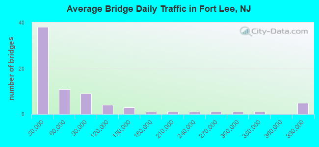
- 5,675,317Total average daily traffic
- 415,695Total average daily truck traffic
- National Bridge Inventory (NBI) Registered Bridges for Fort Lee
- No street view available for this location

- New bridges - historical statistics
- 261930-1939
- 111950-1959
- 291960-1969
- 32000-2009
- 72010-2019
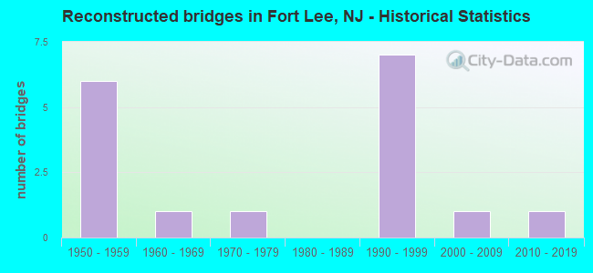
- Reconstructed bridges - Historical Statistics
- 61950-1959
- 11960-1969
- 11970-1979
- 01980-1989
- 71990-1999
- 12000-2009
- 12010-2019
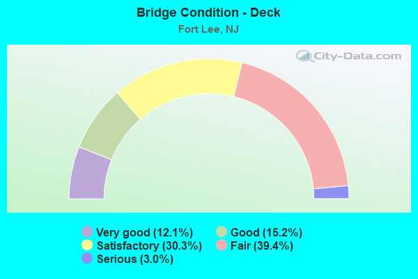
- Bridge Condition - Deck
- 12.1%Very good
- 15.2%Good
- 30.3%Satisfactory
- 39.4%Fair
- 3.0%Serious
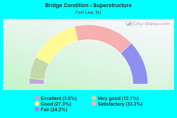
- Bridge Condition - Superstructure
- 3.0%Excellent
- 12.1%Very good
- 27.3%Good
- 33.3%Satisfactory
- 24.2%Fair
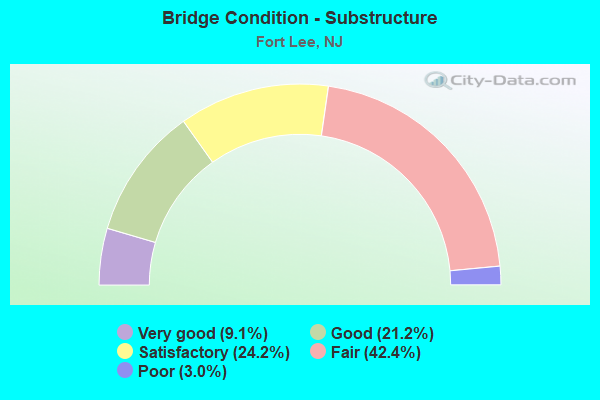
- Bridge Condition - Substructure
- 9.1%Very good
- 21.2%Good
- 24.2%Satisfactory
- 42.4%Fair
- 3.0%Poor
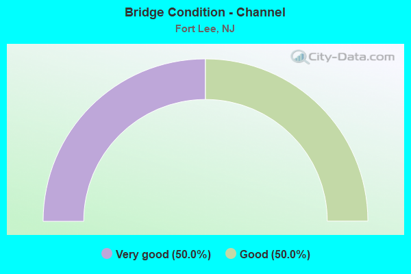
- Bridge Condition - Channel
- 50.0%Very good
- 50.0%Good
Find on map >> Show street view
Structure Number: 202156, Location: 1.7 MI WEST OF GWB (Lat: 40.851261, Lng: -73.985500), Route carried "on" structure: US 1, Year Built: 1931, Year Reconstructed: 1995, Status: Open, Structure Length: 1.98m (6.50ft), Average Daily Traffic: 41,150 (year 2020), Truck Traffic: 4%, Average Future Daily Traffic: 50,203 (year 2040), Design Load: HS 20+Mod, Features Intersected: NJ 63 SB
Minimum Vertical Clearance: 30.45m (99.90ft), Kilometerpoint: 102.918, Lanes on structure: 4, Lanes under structure: 1, Base Highway Network: Yes, Owner: State Highway Agency, Approaching Roadway Width: 21.0m (68.9ft), Skew: 34 degrees, Material/Design: Steel, Design/Construction: Stringer/Multi-beam, Number Of Spans In Main Unit: 1, Length of Maximum Span: 18.0m (59.1ft), Curb-To-Curb Width: 21.2m (69.6ft), Out-to-Out Width: 23.0m (75.5ft)
Condition: Deck: Good, Superstructure: Good, Substructure: Satisfactory, Operating Rating: 86.2 metric tons, Method Used To Determine Operating Rating: Load Factor (LF), Inventory Rating: 51.7 metric tons, Method Used To Determine Inventory Rating: Load Factor (LF), Structural Evaluation: Equal to present minimum criteria, Deck Geometry: Superior to present desirable criteria, Underclear: Somewhat better than minimum adequacy, Approach Roadway Alignment: Equal to present minimum criteria, Designated Inspection Frequency: Every 24 months, Inspection Date: May 2020, Deck Structure Type: Concrete Cast-file-Place, Wearing Surface/Protective System: Wearing Surface: Latex Concrete, Deck Protection: Epoxy Coated Reinforcing
Find on map >> Show street view
Structure Number: 202158, Location: 1.1 MI WEST OF GWB (Lat: 40.857931, Lng: -73.980581), Route carried "on" structure: US 1, Year Built: 1930, Year Reconstructed: 1995, Status: Open, Structure Length: 1.92m (6.30ft), Average Daily Traffic: 60,609 (year 2020), Truck Traffic: 4%, Average Future Daily Traffic: 73,943 (year 2040), Features Intersected: MAIN STREET (CR 56 III)
Minimum Vertical Clearance: 30.45m (99.90ft), Kilometerpoint: 103.787, Lanes on structure: 4, Lanes under structure: 2, Base Highway Network: Yes, Owner: State Highway Agency, Approaching Roadway Width: 20.4m (66.9ft), Skew: 31 degrees, Material/Design: Steel, Design/Construction: Stringer/Multi-beam, Number Of Spans In Main Unit: 1, Length of Maximum Span: 18.3m (60.0ft), Curb-To-Curb Width: 20.5m (67.3ft), Out-to-Out Width: 22.3m (73.2ft)
Condition: Deck: Satisfactory, Superstructure: Good, Substructure: Satisfactory, Operating Rating: 73.5 metric tons, Method Used To Determine Operating Rating: Load Factor (LF), Inventory Rating: 43.5 metric tons, Method Used To Determine Inventory Rating: Load Factor (LF), Structural Evaluation: Equal to present minimum criteria, Deck Geometry: Superior to present desirable criteria, Underclear: High priority of corrective action, Approach Roadway Alignment: Equal to present minimum criteria, Length Of Structure Improvement: 1.92m (6.30ft), Designated Inspection Frequency: Every 24 months, Inspection Date: April 2020, Roadway Improvement Cost: $1,000, Total Project Cost: $1,000 ( Estimate for 2020), Deck Structure Type: Concrete Cast-file-Place, Wearing Surface/Protective System: Wearing Surface: Latex Concrete, Deck Protection: Epoxy Coated Reinforcing
Find on map >> Show street view
Structure Number: 202159, Location: 1.05 MI. West of GWB (Lat: 40.858281, Lng: -73.978711), Route carried "on" structure: US 1, Year Built: 1930, Year Reconstructed: 2017, Status: Open, Structure Length: 1.95m (6.40ft), Average Daily Traffic: 60,609 (year 2020), Truck Traffic: 4%, Average Future Daily Traffic: 73,943 (year 2040), Design Load: HL 93, Features Intersected: JONES ROAD
Minimum Vertical Clearance: 30.45m (99.90ft), Kilometerpoint: 103.931, Lanes on structure: 4, Lanes under structure: 2, Base Highway Network: Yes, Owner: State Highway Agency, Approaching Roadway Width: 17.7m (58.1ft), Skew: 32 degrees, Material/Design: Steel, Design/Construction: Stringer/Multi-beam, Number Of Spans In Main Unit: 1, Length of Maximum Span: 18.3m (60.0ft), Curb or Sidewalk Widths: Left: 1.6m (5.2ft), Right: 1.6m (5.2ft), Curb-To-Curb Width: 17.7m (58.1ft), Out-to-Out Width: 22.0m (72.2ft)
Condition: Deck: Very good, Superstructure: Very good, Substructure: Good, Operating Rating: 78.7 metric tons, Method Used To Determine Operating Rating: Load and Resistance Factor Rating (LRFR) rating reported by rating factor(RF) method using HL-93 loadings, Inventory Rating: 71.9 metric tons, Method Used To Determine Inventory Rating: Load and Resistance Factor Rating (LRFR) rating reported by rating factor(RF) method using HL-93 loadings, Structural Evaluation: Better than present minimum criteria, Deck Geometry: Somewhat better than minimum adequacy, Underclear: Meets minimum limits, Approach Roadway Alignment: Better than present minimum criteria, Length Of Structure Improvement: 1.95m (6.40ft), Designated Inspection Frequency: Every 24 months, Inspection Date: April 2020, Bridge Improvement Cost: $982,000, Roadway Improvement Cost: $129,000, Total Project Cost: $1,258,000 ( Estimate for 2016), Deck Structure Type: Concrete Precast Panels, Wearing Surface/Protective System: Deck Protection: Epoxy Coated Reinforcing
Find on map >> Show street view
Structure Number: 20216, Location: 1.0 MI WEST OF GWB (Lat: 40.858319, Lng: -73.976939), Route carried "on" structure: US 1, Year Built: 2001, Status: Open, Structure Length: 14.57m (47.80ft), Average Daily Traffic: 30,304 (year 2020), Truck Traffic: 4%, Average Future Daily Traffic: 36,971 (year 2040), Design Load: HS 25 or greater, Features Intersected: NJ 4 EB & RAMP B
Minimum Vertical Clearance: 5.82m (19.09ft), Kilometerpoint: 104.060, Lanes on structure: 2, Lanes under structure: 4, Base Highway Network: Yes, Owner: State Highway Agency, Approaching Roadway Width: 11.0m (36.1ft), Material/Design: Steel continuous, Design/Construction: Stringer/Multi-beam, Number Of Spans In Main Unit: 4, Length of Maximum Span: 48.2m (158.1ft), Curb-To-Curb Width: 11.1m (36.4ft), Out-to-Out Width: 12.3m (40.4ft)
Condition: Deck: Good, Superstructure: Very good, Substructure: Good, Operating Rating: 57.2 metric tons, Method Used To Determine Operating Rating: Load Factor (LF), Inventory Rating: 33.6 metric tons, Method Used To Determine Inventory Rating: Load Factor (LF), Structural Evaluation: Better than present minimum criteria, Deck Geometry: Equal to present minimum criteria, Underclear: Somewhat better than minimum adequacy, Approach Roadway Alignment: Better than present minimum criteria, Designated Inspection Frequency: Every 24 months, Inspection Date: May 2020, Deck Structure Type: Concrete Cast-file-Place, Wearing Surface/Protective System: Wearing Surface: Monolithic Concrete, Deck Protection: Epoxy Coated Reinforcing
Find on map >> Show street view
Structure Number: 202161, Location: 0.8 MI W OF GWB TOLL (Lat: 40.858919, Lng: -73.976600), Route carried "on" structure: US 1, Year Built: 1963, Year Reconstructed: 1996, Status: Open, Structure Length: 20.06m (65.81ft), Average Daily Traffic: 32,570 (year 2021), Truck Traffic: 4%, Average Future Daily Traffic: 39,741 (year 2041), Design Load: HS 20, Features Intersected: I-95 & Ramps; NJ4 Ramp B
Minimum Vertical Clearance: 30+ m (98+ ft), Kilometerpoint: 104.060, Lanes on structure: 3, Lanes under structure: 13, Base Highway Network: Yes, Owner: State Highway Agency, Approaching Roadway Width: 12.2m (40.0ft), Skew: 3 degrees, Material/Design: Steel, Design/Construction: Stringer/Multi-beam, Number Of Spans In Main Unit: 8, Length of Maximum Span: 34.7m (113.8ft), Curb or Sidewalk Widths: Left: 1.8m (5.9ft), Right: 0.0m, Curb-To-Curb Width: 12.2m (40.0ft), Out-to-Out Width: 15.1m (49.5ft)
Condition: Deck: Fair, Superstructure: Fair, Substructure: Fair, Operating Rating: 54.4 metric tons, Method Used To Determine Operating Rating: Load Factor (LF), Inventory Rating: 32.7 metric tons, Method Used To Determine Inventory Rating: Load Factor (LF), Structural Evaluation: Somewhat better than minimum adequacy, Deck Geometry: Meets minimum limits, Underclear: High priority of corrective action, Approach Roadway Alignment: Equal to present minimum criteria, Length Of Structure Improvement: 20.06m (65.81ft), Designated Inspection Frequency: Every 24 months, Inspection Date: March 2021, Roadway Improvement Cost: $11,000, Total Project Cost: $32,000 ( Estimate for 2019), Deck Structure Type: Concrete Cast-file-Place, Wearing Surface/Protective System: Wearing Surface: Latex Concrete
Find on map >> Show street view
Structure Number: 206184, Location: 0.58 MI WEST OF US 9W (Lat: 40.865561, Lng: -73.974381), Route carried "on" structure: State highway 4, Year Built: 1962, Year Reconstructed: 1995, Status: Open, Structure Length: 10.21m (33.50ft), Average Daily Traffic: 45,395 (year 2020), Truck Traffic: 5%, Average Future Daily Traffic: 55,382 (year 2040), Design Load: HS 25 or greater, Features Intersected: I-95 EXP & I-95 SB LOCAL
Minimum Vertical Clearance: 30.45m (99.90ft), Kilometerpoint: 16.415, Lanes on structure: 3, Lanes under structure: 8, Base Highway Network: Yes, Owner: State Highway Agency, Approaching Roadway Width: 14.0m (45.9ft), Skew: 6 degrees, Material/Design: Steel, Design/Construction: Stringer/Multi-beam, Number Of Spans In Main Unit: 3, Length of Maximum Span: 43.3m (142.1ft), Curb or Sidewalk Widths: Left: 0.0m, Right: 1.2m (3.9ft), Curb-To-Curb Width: 14.0m (45.9ft), Out-to-Out Width: 16.6m (54.5ft)
Condition: Deck: Satisfactory, Superstructure: Satisfactory, Substructure: Fair, Operating Rating: 78.0 metric tons, Method Used To Determine Operating Rating: Load Factor (LF), Inventory Rating: 46.3 metric tons, Method Used To Determine Inventory Rating: Load Factor (LF), Structural Evaluation: Somewhat better than minimum adequacy, Deck Geometry: Meets minimum limits, Underclear: High priority of corrective action, Approach Roadway Alignment: Equal to present desirable criteria, Length Of Structure Improvement: 10.21m (33.50ft), Designated Inspection Frequency: Every 24 months, Inspection Date: April 2020, Bridge Improvement Cost: $2,000, Total Project Cost: $3,000 ( Estimate for 2020), Deck Structure Type: Concrete Cast-file-Place, Wearing Surface/Protective System: Wearing Surface: Monolithic Concrete, Deck Protection: Epoxy Coated Reinforcing
Find on map >> Show street view
Structure Number: 206185, Location: 0.58 MI WEST OF US 9W (Lat: 40.864581, Lng: -73.974700), Route carried "on" structure: State highway 4, Year Built: 1962, Year Reconstructed: 1995, Status: Open, Structure Length: 5.70m (18.70ft), Average Daily Traffic: 45,395 (year 2020), Truck Traffic: 5%, Average Future Daily Traffic: 55,382 (year 2040), Design Load: HS 20+Mod, Features Intersected: I-95 NB LOCAL LANES
Minimum Vertical Clearance: 30.45m (99.90ft), Kilometerpoint: 17.043, Lanes on structure: 3, Lanes under structure: 4, Base Highway Network: Yes, Owner: State Highway Agency, Approaching Roadway Width: 14.0m (45.9ft), Skew: 6 degrees, Material/Design: Steel, Design/Construction: Stringer/Multi-beam, Number Of Spans In Main Unit: 1, Length of Maximum Span: 55.8m (183.1ft), Curb or Sidewalk Widths: Left: 0.0m, Right: 1.2m (3.9ft), Curb-To-Curb Width: 14.0m (45.9ft), Out-to-Out Width: 16.6m (54.5ft)
Condition: Deck: Good, Superstructure: Good, Substructure: Satisfactory, Inventory Rating: 85.3 metric tons, Method Used To Determine Inventory Rating: Load Factor (LF), Structural Evaluation: Equal to present minimum criteria, Deck Geometry: Meets minimum limits, Underclear: High priority of corrective action, Approach Roadway Alignment: Equal to present desirable criteria, Length Of Structure Improvement: 5.70m (18.70ft), Designated Inspection Frequency: Every 24 months, Inspection Date: April 2020, Bridge Improvement Cost: $1,000, Total Project Cost: $2,000 ( Estimate for 2020), Deck Structure Type: Concrete Cast-file-Place, Wearing Surface/Protective System: Wearing Surface: Monolithic Concrete, Deck Protection: Epoxy Coated Reinforcing
Find on map >> Show street view
Structure Number: 206186, Location: 0.5 MI WEST OF GWB (Lat: 40.860669, Lng: -73.974361), Route carried "on" structure: State highway 4, Year Built: 1962, Year Reconstructed: 1995, Status: Open, Structure Length: 6.19m (20.31ft), Average Daily Traffic: 45,395 (year 2020), Truck Traffic: 5%, Average Future Daily Traffic: 55,382 (year 2040), Design Load: HS 20, Features Intersected: I-95 SB LOCAL&RAMPS F&G
Minimum Vertical Clearance: 30.45m (99.90ft), Kilometerpoint: 17.043, Lanes on structure: 3, Lanes under structure: 4, Base Highway Network: Yes, Owner: State Highway Agency, Approaching Roadway Width: 15.8m (51.8ft), Skew: 36 degrees, Material/Design: Steel, Design/Construction: Stringer/Multi-beam, Number Of Spans In Main Unit: 2, Length of Maximum Span: 41.5m (136.2ft), Curb-To-Curb Width: 16.0m (52.5ft), Out-to-Out Width: 17.7m (58.1ft)
Condition: Deck: Good, Superstructure: Satisfactory, Substructure: Fair, Operating Rating: 33.6 metric tons, Method Used To Determine Operating Rating: Load Factor (LF), Inventory Rating: 20.0 metric tons, Method Used To Determine Inventory Rating: Load Factor (LF), Structural Evaluation: Somewhat better than minimum adequacy, Deck Geometry: Equal to present minimum criteria, Underclear: High priority of corrective action, Approach Roadway Alignment: Better than present minimum criteria, Length Of Structure Improvement: 6.19m (20.31ft), Designated Inspection Frequency: Every 24 months, Inspection Date: April 2020, Roadway Improvement Cost: $1,000, Total Project Cost: $1,000 ( Estimate for 2020), Deck Structure Type: Concrete Cast-file-Place, Wearing Surface/Protective System: Wearing Surface: Monolithic Concrete, Deck Protection: Epoxy Coated Reinforcing
Find on map >> Show street view
Structure Number: 206187, Location: 0.5 MI WEST OF GWB (Lat: 40.858400, Lng: -73.975850), Route carried "on" structure: State highway 4, Year Built: 1930, Year Reconstructed: 1955, Status: Open, Structure Length: 2.47m (8.10ft), Average Daily Traffic: 45,395 (year 2020), Truck Traffic: 5%, Average Future Daily Traffic: 55,382 (year 2040), Features Intersected: I-95 RAMP L
Minimum Vertical Clearance: 5.92m (19.42ft), Kilometerpoint: 17.188, Lanes on structure: 3, Lanes under structure: 1, Base Highway Network: Yes, Owner: State Highway Agency, Approaching Roadway Width: 11.0m (36.1ft), Skew: 5 degrees, Material/Design: Steel, Design/Construction: Girder and Floorbeam System, Number Of Spans In Main Unit: 1, Length of Maximum Span: 23.2m (76.1ft), Curb or Sidewalk Widths: Left: 1.6m (5.2ft), Right: 1.6m (5.2ft), Curb-To-Curb Width: 11.0m (36.1ft), Out-to-Out Width: 11.8m (38.7ft)
Condition: Deck: Fair, Superstructure: Fair, Substructure: Good, Operating Rating: 65.3 metric tons, Method Used To Determine Operating Rating: Load Factor (LF), Inventory Rating: 39.0 metric tons, Method Used To Determine Inventory Rating: Load Factor (LF), Structural Evaluation: Somewhat better than minimum adequacy, Deck Geometry: High priority of replacement, Underclear: High priority of corrective action, Approach Roadway Alignment: Somewhat better than minimum adequacy, Length Of Structure Improvement: 2.47m (8.10ft), Designated Inspection Frequency: Every 24 months, Critical Feature Inspection Frequency: Every 24 months, Inspection Date: April 2020, Critical Feature Inspection Date: April 2020, Bridge Improvement Cost: $2,000, Total Project Cost: $4,000 ( Estimate for 2020), Deck Structure Type: Concrete Cast-file-Place, Wearing Surface/Protective System: Wearing Surface: Bituminous
Find on map >> Show street view
Structure Number: 20915, Location: 0.62 MI W of GWB (Lat: 40.857061, Lng: -73.974200), Route carried "on" structure: US 9W, Year Built: 1930, Year Reconstructed: 1960, Status: Open, Structure Length: 12.95m (42.49ft), Average Daily Traffic: 26,563 (year 2020), Truck Traffic: 4%, Average Future Daily Traffic: 32,407 (year 2040), Design Load: HS 20, Features Intersected: I-95, US1, 9 & 46 & NJ 4
Minimum Vertical Clearance: 30.45m (99.90ft), Kilometerpoint: 0.080, Lanes on structure: 5, Lanes under structure: 17, Base Highway Network: Yes, Owner: State Highway Agency, Approaching Roadway Width: 18.3m (60.0ft), Material/Design: Steel, Design/Construction: Stringer/Multi-beam, Number Of Spans In Main Unit: 7, Length of Maximum Span: 26.5m (86.9ft), Curb or Sidewalk Widths: Left: 3.5m (11.5ft), Right: 3.5m (11.5ft), Curb-To-Curb Width: 18.3m (60.0ft), Out-to-Out Width: 26.2m (86.0ft)
Condition: Deck: Serious, Superstructure: Fair, Substructure: Fair, Operating Rating: 41.7 metric tons, Method Used To Determine Operating Rating: Load Factor (LF), Inventory Rating: 25.4 metric tons, Method Used To Determine Inventory Rating: Load Factor (LF), Structural Evaluation: Somewhat better than minimum adequacy, Deck Geometry: High priority of replacement, Underclear: High priority of replacement, Approach Roadway Alignment: Better than present minimum criteria, Length Of Structure Improvement: 13.87m (45.51ft), Designated Inspection Frequency: Every 24 months, Inspection Date: April 2020, Bridge Improvement Cost: $17,000, Roadway Improvement Cost: $2,000, Total Project Cost: $26,000 ( Estimate for 2020), Deck Structure Type: Concrete Cast-file-Place, Wearing Surface/Protective System: Wearing Surface: Bituminous
Find on map >> Show street view
Structure Number: 209152, Location: 0.6 MI NORTH OF I 95 JCT (Lat: 40.861119, Lng: -73.964331), Route carried "on" structure: US 9W, Year Built: 1931, Year Reconstructed: 1982, Status: Open, Structure Length: 1.71m (5.61ft), Average Daily Traffic: 26,563 (year 2020), Truck Traffic: 4%, Average Future Daily Traffic: 32,407 (year 2040), Design Load: HS 20+Mod, Features Intersected: NJ 67 SB (LEMOINE AVE.)
Minimum Vertical Clearance: 30.45m (99.90ft), Kilometerpoint: 1.062, Lanes on structure: 1, Lanes under structure: 2, Base Highway Network: Yes, Owner: State Highway Agency, Approaching Roadway Width: 7.3m (24.0ft), Skew: 9 degrees, Material/Design: Steel, Design/Construction: Stringer/Multi-beam, Number Of Spans In Main Unit: 1, Length of Maximum Span: 15.8m (51.8ft), Curb or Sidewalk Widths: Left: 1.8m (5.9ft), Right: 2.0m (6.6ft), Curb-To-Curb Width: 7.3m (24.0ft), Out-to-Out Width: 13.0m (42.7ft)
Condition: Deck: Satisfactory, Superstructure: Good, Substructure: Satisfactory, Inventory Rating: 81.6 metric tons, Method Used To Determine Inventory Rating: Load Factor (LF), Structural Evaluation: Equal to present minimum criteria, Deck Geometry: High priority of replacement, Underclear: Meets minimum limits, Approach Roadway Alignment: Somewhat better than minimum adequacy, Designated Inspection Frequency: Every 24 months, Inspection Date: April 2020, Deck Structure Type: Concrete Cast-file-Place, Wearing Surface/Protective System: Wearing Surface: Monolithic Concrete, Deck Protection: Epoxy Coated Reinforcing
Find on map >> Show street view
Structure Number: 3800002, Location: AT 95 & 278 INTERSECTION (Lat: 40.642889, Lng: -74.208050), Route carried "on" structure: Ramp Interstate 278, Year Built: 1966, Status: Open, Structure Length: 3.57m (11.71ft), Average Daily Traffic: 8,391 (year 2020), Truck Traffic: 10%, Average Future Daily Traffic: 10,239 (year 2040), Design Load: HS 20, Features Intersected: I-278
Minimum Vertical Clearance: 30+ m (98+ ft), Kilometerpoint: 0.000, Lanes on structure: 1, Lanes under structure: 3, Toll: Toll bridge, Owner: State Agenciy, Approaching Roadway Width: 8.5m (27.9ft), Skew: 4 degrees, Material/Design: Steel continuous, Design/Construction: Stringer/Multi-beam, Number Of Spans In Main Unit: 2, Length of Maximum Span: 21.0m (68.9ft), Curb or Sidewalk Widths: Left: 0.6m (2.0ft), Right: 0.6m (2.0ft), Curb-To-Curb Width: 8.6m (28.2ft), Out-to-Out Width: 10.5m (34.4ft)
Condition: Deck: Satisfactory, Superstructure: Good, Substructure: Satisfactory, Operating Rating: 70.8 metric tons, Method Used To Determine Operating Rating: Load Factor (LF), Inventory Rating: 41.7 metric tons, Method Used To Determine Inventory Rating: Load Factor (LF), Structural Evaluation: Equal to present minimum criteria, Deck Geometry: Superior to present desirable criteria, Underclear: High priority of corrective action, Approach Roadway Alignment: Better than present minimum criteria, Designated Inspection Frequency: Every 24 months, Inspection Date: May 2020, Deck Structure Type: Concrete Cast-file-Place, Wearing Surface/Protective System: Wearing Surface: Bituminous
Find on map >> Show street view
Structure Number: 3800004, Location: 0.65 MI W OF GEO WASH BR (Lat: 40.856200, Lng: -73.972639), Route carried "on" structure: City street 29, Year Built: 1931, Year Reconstructed: 1964, Status: Open, Structure Length: 7.47m (24.51ft), Average Daily Traffic: 12,184 (year 2021), Truck Traffic: 3%, Average Future Daily Traffic: 16,090 (year 2041), Features Intersected: I-95
Minimum Vertical Clearance: 30+ m (98+ ft), Kilometerpoint: 5.826, Lanes on structure: 2, Lanes under structure: 17, Owner: State Toll Authority, Maintenance Responsibility: Private, Approaching Roadway Width: 9.1m (29.9ft), Material/Design: Steel, Design/Construction: Girder and Floorbeam System, Number Of Spans In Main Unit: 4, Length of Maximum Span: 21.0m (68.9ft), Curb or Sidewalk Widths: Left: 2.7m (8.9ft), Right: 2.7m (8.9ft), Curb-To-Curb Width: 9.1m (29.9ft), Out-to-Out Width: 16.7m (54.8ft)
Condition: Deck: Fair, Superstructure: Satisfactory, Substructure: Fair, Operating Rating: 58.1 metric tons, Method Used To Determine Operating Rating: Load Factor (LF), Inventory Rating: 35.4 metric tons, Method Used To Determine Inventory Rating: Load Factor (LF), Structural Evaluation: Somewhat better than minimum adequacy, Deck Geometry: Meets minimum limits, Underclear: High priority of corrective action, Approach Roadway Alignment: Equal to present desirable criteria, Designated Inspection Frequency: Every 24 months, Critical Feature Inspection Frequency: Every 24 months, Inspection Date: June 2021, Critical Feature Inspection Date: June 2021, Deck Structure Type: Concrete Cast-file-Place, Wearing Surface/Protective System: Wearing Surface: Latex Concrete, Deck Protection: Epoxy Coated Reinforcing
Find on map >> Show street view
Structure Number: 3800005, Location: 0.55 MI W OF GEO WASH BR (Lat: 40.854861, Lng: -73.970769), Route carried "on" structure: City street , Year Built: 1931, Year Reconstructed: 1964, Status: Open, Structure Length: 13.08m (42.91ft), Average Daily Traffic: 12,179 (year 2021), Truck Traffic: 3%, Average Future Daily Traffic: 16,090 (year 2041), Features Intersected: I-95, Facility Carried by Structure: CENTER AVENUE
Minimum Vertical Clearance: 30+ m (98+ ft), Kilometerpoint: 0.000, Lanes on structure: 2, Lanes under structure: 17, Owner: State Toll Authority, Maintenance Responsibility: Private, Approaching Roadway Width: 12.2m (40.0ft), Skew: 9 degrees, Material/Design: Steel, Design/Construction: Stringer/Multi-beam, Number Of Spans In Main Unit: 7, Length of Maximum Span: 32.6m (107.0ft), Curb or Sidewalk Widths: Left: 3.1m (10.2ft), Right: 3.1m (10.2ft), Curb-To-Curb Width: 12.2m (40.0ft), Out-to-Out Width: 19.0m (62.3ft)
Condition: Deck: Fair, Superstructure: Satisfactory, Substructure: Satisfactory, Operating Rating: 51.7 metric tons, Method Used To Determine Operating Rating: Load Factor (LF), Inventory Rating: 30.8 metric tons, Method Used To Determine Inventory Rating: Load Factor (LF), Structural Evaluation: Equal to present minimum criteria, Deck Geometry: Better than present minimum criteria, Underclear: High priority of corrective action, Approach Roadway Alignment: Equal to present desirable criteria, Designated Inspection Frequency: Every 24 months, Inspection Date: May 2021, Deck Structure Type: Concrete Cast-file-Place, Wearing Surface/Protective System: Wearing Surface: Bituminous
Find on map >> Show street view
Structure Number: 3800006, Location: .55 MI W OF GEO WASH BR (Lat: 40.855431, Lng: -73.969989), Route carried "on" structure: Ramp Interstate 95, Year Built: 1959, Status: Open, Structure Length: 7.99m (26.21ft), Average Daily Traffic: 3,980 (year 2021), Truck Traffic: 9%, Average Future Daily Traffic: 5,300 (year 2041), Features Intersected: NONE
Minimum Vertical Clearance: 30+ m (98+ ft), Kilometerpoint: 123.952, Lanes on structure: 1, Base Highway Network: Yes, Toll: On toll road, Owner: State Toll Authority, Maintenance Responsibility: Private, Approaching Roadway Width: 5.5m (18.0ft), Material/Design: Concrete, Design/Construction: Frame, Number Of Spans In Main Unit: 9, Length of Maximum Span: 13.4m (44.0ft), Curb or Sidewalk Widths: Left: 0.6m (2.0ft), Right: 1.5m (4.9ft), Curb-To-Curb Width: 5.5m (18.0ft), Out-to-Out Width: 8.2m (26.9ft)
Condition: Deck: Fair, Superstructure: Fair, Substructure: Good, Operating Rating: 64.4 metric tons, Method Used To Determine Operating Rating: Load Factor (LF), Inventory Rating: 38.1 metric tons, Method Used To Determine Inventory Rating: Load Factor (LF), Structural Evaluation: Somewhat better than minimum adequacy, Deck Geometry: Meets minimum limits, Approach Roadway Alignment: Equal to present minimum criteria, Designated Inspection Frequency: Every 24 months, Inspection Date: May 2021, Deck Structure Type: Concrete Cast-file-Place, Wearing Surface/Protective System: Wearing Surface: Monolithic Concrete
Find on map >> Show street view
Structure Number: 3800007, Location: .55 MI W OF GEO WASH BR (Lat: 40.855100, Lng: -73.970331), Route carried "on" structure: Ramp Interstate 95, Year Built: 1959, Status: Open, Structure Length: 7.99m (26.21ft), Average Daily Traffic: 1,265 (year 2021), Truck Traffic: 9%, Average Future Daily Traffic: 1,700 (year 2041), Features Intersected: NONE
Minimum Vertical Clearance: 30+ m (98+ ft), Kilometerpoint: 123.952, Lanes on structure: 1, Base Highway Network: Yes, Toll: On toll road, Owner: State Toll Authority, Maintenance Responsibility: Private, Approaching Roadway Width: 5.5m (18.0ft), Material/Design: Concrete, Design/Construction: Frame, Number Of Spans In Main Unit: 10, Length of Maximum Span: 8.8m (28.9ft), Curb or Sidewalk Widths: Left: 0.6m (2.0ft), Right: 0.6m (2.0ft), Curb-To-Curb Width: 5.5m (18.0ft), Out-to-Out Width: 7.3m (24.0ft)
Condition: Deck: Fair, Superstructure: Fair, Substructure: Good, Operating Rating: 72.6 metric tons, Method Used To Determine Operating Rating: Load Factor (LF), Inventory Rating: 43.5 metric tons, Method Used To Determine Inventory Rating: Load Factor (LF), Structural Evaluation: Somewhat better than minimum adequacy, Deck Geometry: Meets minimum limits, Approach Roadway Alignment: Equal to present minimum criteria, Designated Inspection Frequency: Every 24 months, Inspection Date: May 2021, Deck Structure Type: Concrete Cast-file-Place, Wearing Surface/Protective System: Wearing Surface: Monolithic Concrete
Find on map >> Show street view
Structure Number: 3800008, Location: 0.4 MI. WEST OF GW BRIDGE (Lat: 40.854169, Lng: -73.970039), Route carried "on" structure: City street , Year Built: 1960, Status: Open, Structure Length: 8.44m (27.69ft), Average Daily Traffic: 22,000 (year 2021), Truck Traffic: 1%, Average Future Daily Traffic: 29,100 (year 2041), Features Intersected: PA ADM PARKING GARAGE, Facility Carried by Structure: BRUCE REYNOLDS BLV
Minimum Vertical Clearance: 30+ m (98+ ft), Kilometerpoint: 0.000, Lanes on structure: 3, Lanes under structure: 2, Owner: State Toll Authority, Maintenance Responsibility: Private, Approaching Roadway Width: 12.2m (40.0ft), Material/Design: Steel, Design/Construction: Stringer/Multi-beam, Number Of Spans In Main Unit: 8, Length of Maximum Span: 16.8m (55.1ft), Curb or Sidewalk Widths: Left: 3.0m (9.8ft), Right: 3.0m (9.8ft), Curb-To-Curb Width: 12.2m (40.0ft), Out-to-Out Width: 18.9m (62.0ft)
Condition: Deck: Satisfactory, Superstructure: Good, Substructure: Satisfactory, Operating Rating: 59.9 metric tons, Method Used To Determine Operating Rating: Load Factor (LF), Inventory Rating: 35.4 metric tons, Method Used To Determine Inventory Rating: Load Factor (LF), Structural Evaluation: Equal to present minimum criteria, Deck Geometry: Meets minimum limits, Underclear: High priority of corrective action, Approach Roadway Alignment: Equal to present desirable criteria, Designated Inspection Frequency: Every 24 months, Inspection Date: May 2021, Deck Structure Type: Concrete Cast-file-Place, Wearing Surface/Protective System: Wearing Surface: Bituminous
Find on map >> Show street view
Structure Number: 3800009, Location: 0.38 MI W OF GEO WASH BR (Lat: 40.854100, Lng: -73.968411), Route carried "on" structure: State highway 67, Year Built: 1931, Year Reconstructed: 1999, Status: Open, Structure Length: 12.19m (39.99ft), Average Daily Traffic: 24,388 (year 2021), Truck Traffic: 4%, Average Future Daily Traffic: 32,300 (year 2041), Features Intersected: I-95
Minimum Vertical Clearance: 30+ m (98+ ft), Kilometerpoint: 2.205, Lanes on structure: 4, Lanes under structure: 20, Base Highway Network: Yes, Owner: State Toll Authority, Maintenance Responsibility: Private, Approaching Roadway Width: 19.8m (65.0ft), Skew: 1 degrees, Material/Design: Steel, Design/Construction: Stringer/Multi-beam, Number Of Spans In Main Unit: 7, Length of Maximum Span: 18.0m (59.1ft), Curb or Sidewalk Widths: Left: 5.4m (17.7ft), Right: 5.4m (17.7ft), Curb-To-Curb Width: 19.8m (65.0ft), Out-to-Out Width: 31.2m (102.4ft)
Condition: Deck: Fair, Superstructure: Satisfactory, Substructure: Fair, Operating Rating: 45.4 metric tons, Method Used To Determine Operating Rating: Load Factor (LF), Inventory Rating: 27.2 metric tons, Method Used To Determine Inventory Rating: Load Factor (LF), Structural Evaluation: Somewhat better than minimum adequacy, Deck Geometry: Better than present minimum criteria, Underclear: High priority of corrective action, Approach Roadway Alignment: Equal to present desirable criteria, Designated Inspection Frequency: Every 24 months, Inspection Date: May 2021, Deck Structure Type: Concrete Cast-file-Place, Wearing Surface/Protective System: Wearing Surface: Latex Concrete, Deck Protection: Epoxy Coated Reinforcing
Find on map >> Show street view
Structure Number: 380001, Location: 0.35 MI W OF GEO WASH BR (Lat: 40.854831, Lng: -73.966700), Route carried "on" structure: Ramp Interstate 95, Year Built: 1964, Status: Open, Structure Length: 1.46m (4.79ft), Average Daily Traffic: 24,347 (year 2021), Truck Traffic: 3%, Average Future Daily Traffic: 32,200 (year 2041), Features Intersected: I-95 SB(LOWER LEVEL WB), Facility Carried by Structure: HUDSON ST RAMP
Minimum Vertical Clearance: 30+ m (98+ ft), Kilometerpoint: 0.000, Lanes on structure: 2, Lanes under structure: 3, Owner: State Toll Authority, Maintenance Responsibility: Private, Approaching Roadway Width: 22.9m (75.1ft), Skew: 30 degrees, Material/Design: Steel, Design/Construction: Stringer/Multi-beam, Number Of Spans In Main Unit: 1, Length of Maximum Span: 13.4m (44.0ft), Curb or Sidewalk Widths: Left: 3.5m (11.5ft), Right: 2.0m (6.6ft), Curb-To-Curb Width: 23.0m (75.5ft), Out-to-Out Width: 43.1m (141.4ft)
Condition: Deck: Fair, Superstructure: Satisfactory, Substructure: Fair, Operating Rating: 41.7 metric tons, Method Used To Determine Operating Rating: Load Factor (LF), Inventory Rating: 24.5 metric tons, Method Used To Determine Inventory Rating: Load Factor (LF), Structural Evaluation: Somewhat better than minimum adequacy, Deck Geometry: Superior to present desirable criteria, Underclear: High priority of corrective action, Approach Roadway Alignment: Somewhat better than minimum adequacy, Designated Inspection Frequency: Every 24 months, Inspection Date: May 2021, Deck Structure Type: Concrete Cast-file-Place, Wearing Surface/Protective System: Wearing Surface: Bituminous
Find on map >> Show street view
Structure Number: 3800011, Location: 0.35 MI W OF GEO WASH BR (Lat: 40.853900, Lng: -73.967081), Route carried "on" structure: Ramp City street 95, Year Built: 1964, Status: Open, Structure Length: 1.49m (4.89ft), Average Daily Traffic: 19,717 (year 2021), Truck Traffic: 3%, Average Future Daily Traffic: 26,100 (year 2041), Design Load: HS 20, Features Intersected: I-95 NB (LOWER LEVEL EB), Facility Carried by Structure: HUDSON ST RAMP
Minimum Vertical Clearance: 30+ m (98+ ft), Kilometerpoint: 0.000, Lanes on structure: 4, Lanes under structure: 3, Owner: State Toll Authority, Maintenance Responsibility: Private, Approaching Roadway Width: 15.2m (49.9ft), Material/Design: Steel, Design/Construction: Stringer/Multi-beam, Number Of Spans In Main Unit: 1, Length of Maximum Span: 13.4m (44.0ft), Curb or Sidewalk Widths: Left: 3.1m (10.2ft), Right: 1.5m (4.9ft), Curb-To-Curb Width: 15.2m (49.9ft), Out-to-Out Width: 26.3m (86.3ft)
Condition: Deck: Fair, Superstructure: Good, Substructure: Fair, Operating Rating: 61.7 metric tons, Method Used To Determine Operating Rating: Load Factor (LF), Inventory Rating: 37.2 metric tons, Method Used To Determine Inventory Rating: Load Factor (LF), Structural Evaluation: Somewhat better than minimum adequacy, Deck Geometry: High priority of replacement, Underclear: High priority of corrective action, Approach Roadway Alignment: Somewhat better than minimum adequacy, Designated Inspection Frequency: Every 24 months, Inspection Date: May 2021, Deck Structure Type: Concrete Cast-file-Place, Wearing Surface/Protective System: Wearing Surface: Bituminous
Find on map >> Show street view
Structure Number: 3800013, Location: 0.25 MI W OF GEO WASH BR (Lat: 40.854431, Lng: -73.964769), Route carried "on" structure: Ramp Interstate 95, Year Built: 1959, Status: Open, Structure Length: 3.84m (12.60ft), Average Daily Traffic: 7,916 (year 2021), Truck Traffic: 9%, Average Future Daily Traffic: 10,500 (year 2041), Features Intersected: I-95 SB (LOWER LEVEL WB)
Minimum Vertical Clearance: 30+ m (98+ ft), Kilometerpoint: 0.000, Lanes on structure: 2, Lanes under structure: 3, Toll: On toll road, Owner: State Toll Authority, Maintenance Responsibility: Private, Approaching Roadway Width: 7.3m (24.0ft), Skew: 6 degrees, Material/Design: Steel, Design/Construction: Stringer/Multi-beam, Number Of Spans In Main Unit: 1, Length of Maximum Span: 36.0m (118.1ft), Curb or Sidewalk Widths: Left: 2.4m (7.9ft), Right: 2.4m (7.9ft), Curb-To-Curb Width: 7.3m (24.0ft), Out-to-Out Width: 12.9m (42.3ft)
Condition: Deck: Satisfactory, Superstructure: Satisfactory, Substructure: Fair, Operating Rating: 70.8 metric tons, Method Used To Determine Operating Rating: Load Factor (LF), Inventory Rating: 41.7 metric tons, Method Used To Determine Inventory Rating: Load Factor (LF), Structural Evaluation: Somewhat better than minimum adequacy, Deck Geometry: High priority of replacement, Underclear: High priority of corrective action, Approach Roadway Alignment: Equal to present minimum criteria, Designated Inspection Frequency: Every 24 months, Inspection Date: June 2021, Deck Structure Type: Concrete Cast-file-Place, Wearing Surface/Protective System: Wearing Surface: Monolithic Concrete
Find on map >> Show street view
Structure Number: 3800014, Location: 0.15 MI W OF GEO WASH BR (Lat: 40.853461, Lng: -73.963939), Route carried "on" structure: County highway 505, Year Built: 1964, Status: Open, Structure Length: 1.49m (4.89ft), Average Daily Traffic: 11,730 (year 2021), Truck Traffic: 4%, Average Future Daily Traffic: 15,490 (year 2041), Design Load: HS 20, Features Intersected: I-95 NB (LOWER LEVEL EB)
Minimum Vertical Clearance: 30+ m (98+ ft), Kilometerpoint: 12.102, Lanes on structure: 4, Lanes under structure: 3, Base Highway Network: Yes, Owner: State Toll Authority, Maintenance Responsibility: Private, Approaching Roadway Width: 18.3m (60.0ft), Material/Design: Steel, Design/Construction: Stringer/Multi-beam, Number Of Spans In Main Unit: 1, Length of Maximum Span: 13.4m (44.0ft), Curb or Sidewalk Widths: Left: 3.0m (9.8ft), Right: 3.0m (9.8ft), Curb-To-Curb Width: 18.3m (60.0ft), Out-to-Out Width: 25.0m (82.0ft)
Condition: Deck: Fair, Superstructure: Good, Substructure: Fair, Operating Rating: 58.1 metric tons, Method Used To Determine Operating Rating: Load Factor (LF), Inventory Rating: 34.5 metric tons, Method Used To Determine Inventory Rating: Load Factor (LF), Structural Evaluation: Somewhat better than minimum adequacy, Deck Geometry: Somewhat better than minimum adequacy, Underclear: High priority of corrective action, Approach Roadway Alignment: Equal to present desirable criteria, Designated Inspection Frequency: Every 24 months, Inspection Date: May 2021, Deck Structure Type: Concrete Cast-file-Place, Wearing Surface/Protective System: Wearing Surface: Bituminous
Find on map >> Show street view
Structure Number: 3800015, Location: 0.15 MI W OF GEO WASH BR (Lat: 40.854111, Lng: -73.963611), Route carried "on" structure: County highway 505, Year Built: 1964, Status: Open, Structure Length: 1.49m (4.89ft), Average Daily Traffic: 11,735 (year 2021), Truck Traffic: 4%, Average Future Daily Traffic: 15,500 (year 2041), Features Intersected: I-95 SB(LOWER LEVEL WB), Facility Carried by Structure: HUDSON TERRACE
Minimum Vertical Clearance: 30+ m (98+ ft), Kilometerpoint: 12.183, Lanes on structure: 4, Lanes under structure: 3, Base Highway Network: Yes, Owner: State Toll Authority, Maintenance Responsibility: Private, Approaching Roadway Width: 18.3m (60.0ft), Material/Design: Steel, Design/Construction: Stringer/Multi-beam, Number Of Spans In Main Unit: 1, Length of Maximum Span: 13.4m (44.0ft), Curb or Sidewalk Widths: Left: 3.0m (9.8ft), Right: 3.0m (9.8ft), Curb-To-Curb Width: 18.3m (60.0ft), Out-to-Out Width: 25.0m (82.0ft)
Condition: Deck: Satisfactory, Superstructure: Satisfactory, Substructure: Fair, Operating Rating: 59.9 metric tons, Method Used To Determine Operating Rating: Load Factor (LF), Inventory Rating: 35.4 metric tons, Method Used To Determine Inventory Rating: Load Factor (LF), Structural Evaluation: Somewhat better than minimum adequacy, Deck Geometry: Somewhat better than minimum adequacy, Underclear: High priority of corrective action, Approach Roadway Alignment: Equal to present desirable criteria, Designated Inspection Frequency: Every 24 months, Inspection Date: June 2021, Deck Structure Type: Concrete Cast-file-Place, Wearing Surface/Protective System: Wearing Surface: Bituminous
Find on map >> Show street view
Structure Number: 3800016, Location: 0.15 MI W OF GEO WASH BR (Lat: 40.853681, Lng: -73.964061), Route carried "on" structure: Interstate 95, Year Built: 1930, Year Reconstructed: 1964, Status: Open, Structure Length: 5.18m (16.99ft), Average Daily Traffic: 229,806 (year 2021), Truck Traffic: 9%, Average Future Daily Traffic: 303,500 (year 2041), Features Intersected: HUDSON TERRACE (RT 505)
Minimum Vertical Clearance: 5.18m (16.99ft), Kilometerpoint: 124.563, Lanes on structure: 7, Lanes under structure: 4, Base Highway Network: Yes, Toll: On toll road, Owner: State Toll Authority, Maintenance Responsibility: Private, Approaching Roadway Width: 31.4m (103.0ft), Skew: 30 degrees, Material/Design: Steel, Design/Construction: Stringer/Multi-beam, Number Of Spans In Main Unit: 4, Length of Maximum Span: 14.3m (46.9ft), Curb or Sidewalk Widths: Left: 0.6m (2.0ft), Right: 0.6m (2.0ft), Curb-To-Curb Width: 31.4m (103.0ft), Out-to-Out Width: 34.4m (112.9ft)
Condition: Deck: Satisfactory, Superstructure: Satisfactory, Substructure: Satisfactory, Operating Rating: 47.2 metric tons, Method Used To Determine Operating Rating: Load Factor (LF), Inventory Rating: 28.1 metric tons, Method Used To Determine Inventory Rating: Load Factor (LF), Structural Evaluation: Equal to present minimum criteria, Deck Geometry: Equal to present minimum criteria, Underclear: High priority of corrective action, Approach Roadway Alignment: Equal to present desirable criteria, Designated Inspection Frequency: Every 24 months, Critical Feature Inspection Frequency: Every 24 months, Inspection Date: June 2021, Critical Feature Inspection Date: June 2021, Deck Structure Type: Concrete Cast-file-Place, Wearing Surface/Protective System: Wearing Surface: Bituminous
Find on map >> Show street view
Structure Number: 3800018, Location: 0.1 MI. W OF GEO.WASH. BR (Lat: 40.853300, Lng: -73.962611), Route carried "on" structure: Interstate 95, Year Built: 1930, Year Reconstructed: 1964, Status: Open, Structure Length: 11.89m (39.01ft), Average Daily Traffic: 265,853 (year 2021), Truck Traffic: 9%, Average Future Daily Traffic: 351,100 (year 2041), Features Intersected: I-95 TUNNELS
Minimum Vertical Clearance: 6.20m (20.34ft), Kilometerpoint: 124.644, Lanes on structure: 8, Base Highway Network: Yes, Toll: On toll road, Owner: State Toll Authority, Maintenance Responsibility: Private, Approaching Roadway Width: 40.8m (133.9ft), Skew: 30 degrees, Material/Design: Concrete, Design/Construction: Frame, Number Of Spans In Main Unit: 1, Length of Maximum Span: 117.3m (384.8ft), Curb or Sidewalk Widths: Left: 1.5m (4.9ft), Right: 1.6m (5.2ft), Curb-To-Curb Width: 33.5m (109.9ft), Out-to-Out Width: 37.5m (123.0ft)
Condition: Deck: Good, Superstructure: Good, Substructure: Good, Operating Rating: 63.5 metric tons, Method Used To Determine Operating Rating: Load Factor (LF), Inventory Rating: 38.1 metric tons, Method Used To Determine Inventory Rating: Load Factor (LF), Structural Evaluation: Better than present minimum criteria, Deck Geometry: Meets minimum limits, Approach Roadway Alignment: Equal to present desirable criteria, Designated Inspection Frequency: Every 24 months, Inspection Date: June 2021, Deck Structure Type: Concrete Cast-file-Place, Wearing Surface/Protective System: Wearing Surface: Bituminous, Membrane: Built-up
Find on map >> Show street view
Structure Number: 380007, Location: 2.81 MI S OF INT. 14 (Lat: 40.670000, Lng: -74.178669), Route carried "on" structure: City street , Year Built: 1951, Year Reconstructed: 2000, Status: Open, Structure Length: 15.27m (50.10ft), Average Daily Traffic: 18,444 (year 2020), Truck Traffic: 14%, Average Future Daily Traffic: 24,848 (year 2040), Design Load: HS 20, Features Intersected: NJTPK&RAMP TN, Facility Carried by Structure: NORTH AVE EB
Minimum Vertical Clearance: 30+ m (98+ ft), Kilometerpoint: 2.929, Lanes on structure: 3, Lanes under structure: 18, Owner: State Toll Authority, Approaching Roadway Width: 12.2m (40.0ft), Material/Design: Steel, Design/Construction: Stringer/Multi-beam, Number Of Spans In Main Unit: 5, Length of Maximum Span: 35.1m (115.2ft), Curb or Sidewalk Widths: Left: 0.3m (1.0ft), Right: 0.9m (3.0ft), Curb-To-Curb Width: 12.2m (40.0ft), Out-to-Out Width: 14.0m (45.9ft)
Condition: Deck: Fair, Superstructure: Fair, Substructure: Poor, Operating Rating: 75.3 metric tons, Method Used To Determine Operating Rating: Load Factor (LF), Inventory Rating: 44.5 metric tons, Method Used To Determine Inventory Rating: Load Factor (LF), Structural Evaluation: Meets minimum limits, Deck Geometry: Meets minimum limits, Underclear: High priority of corrective action, Approach Roadway Alignment: Better than present minimum criteria, Designated Inspection Frequency: Every 24 months, Inspection Date: May 2020, Deck Structure Type: Concrete Cast-file-Place, Wearing Surface/Protective System: Wearing Surface: Latex Concrete, Deck Protection: Epoxy Coated Reinforcing
Find on map >> Show street view
Structure Number: 3800077, Location: 0.1 MI WEST OF GWB (Lat: 40.854239, Lng: -73.963150), Route carried "on" structure: Ramp Other road 445, Year Built: 2019, Status: Open, Structure Length: 11.49m (37.70ft), Average Daily Traffic: 35,404 (year 2021), Average Future Daily Traffic: 46,800 (year 2041), Design Load: HL 93, Features Intersected: I-95, Facility Carried by Structure: PIP RAMP
Minimum Vertical Clearance: 30+ m (98+ ft), Kilometerpoint: 0.000, Lanes on structure: 1, Lanes under structure: 15, Toll: On toll road, Owner: State Toll Authority, Maintenance Responsibility: Private, Approaching Roadway Width: 8.5m (27.9ft), Material/Design: Steel, Design/Construction: Stringer/Multi-beam, Number Of Spans In Main Unit: 3, Length of Maximum Span: 38.1m (125.0ft), Curb-To-Curb Width: 8.7m (28.5ft), Out-to-Out Width: 9.8m (32.2ft)
Condition: Deck: Very good, Superstructure: Very good, Substructure: Very good, Operating Rating: 59.0 metric tons, Method Used To Determine Operating Rating: Load and Resistance Factor Rating (LRFR) rating reported by rating factor(RF) method using HL-93 loadings, Inventory Rating: 45.4 metric tons, Method Used To Determine Inventory Rating: Load and Resistance Factor Rating (LRFR) rating reported by rating factor(RF) method using HL-93 loadings, Structural Evaluation: Equal to present desirable criteria, Deck Geometry: Superior to present desirable criteria, Underclear: High priority of corrective action, Approach Roadway Alignment: Equal to present minimum criteria, Designated Inspection Frequency: Every 24 months, Inspection Date: June 2021, Deck Structure Type: Concrete Cast-file-Place, Wearing Surface/Protective System: Wearing Surface: Monolithic Concrete, Deck Protection: Other Coated Reinforcing
Find on map >> Show street view
Structure Number: 3800078, Location: 0.04 MILES SOUTH OF I-95 (Lat: 40.852931, Lng: -73.963781), Route carried "on" structure: Ramp Other road 445, Year Built: 2019, Status: Open, Structure Length: 6.40m (21.00ft), Average Daily Traffic: 35,404 (year 2021), Average Future Daily Traffic: 46,800 (year 2041), Design Load: HL 93, Features Intersected: HUDSON TERRACE (RT 505), Facility Carried by Structure: PIP RAMP
Minimum Vertical Clearance: 30+ m (98+ ft), Kilometerpoint: 0.000, Lanes on structure: 1, Lanes under structure: 5, Toll: On toll road, Owner: State Toll Authority, Maintenance Responsibility: Private, Approaching Roadway Width: 9.1m (29.9ft), Skew: 9 degrees, Material/Design: Steel, Design/Construction: Stringer/Multi-beam, Number Of Spans In Main Unit: 3, Length of Maximum Span: 32.0m (105.0ft), Curb-To-Curb Width: 9.3m (30.5ft), Out-to-Out Width: 10.4m (34.1ft)
Condition: Deck: Very good, Superstructure: Excellent, Substructure: Very good, Operating Rating: 78.7 metric tons, Method Used To Determine Operating Rating: Load and Resistance Factor Rating (LRFR) rating reported by rating factor(RF) method using HL-93 loadings, Inventory Rating: 60.9 metric tons, Method Used To Determine Inventory Rating: Load and Resistance Factor Rating (LRFR) rating reported by rating factor(RF) method using HL-93 loadings, Structural Evaluation: Equal to present desirable criteria, Deck Geometry: Superior to present desirable criteria, Underclear: Meets minimum limits, Approach Roadway Alignment: Equal to present minimum criteria, Designated Inspection Frequency: Every 24 months, Inspection Date: June 2021, Deck Structure Type: Concrete Cast-file-Place, Wearing Surface/Protective System: Wearing Surface: Monolithic Concrete, Deck Protection: Other Coated Reinforcing
Find on map >> Show street view
Structure Number: 3800079, Location: 0.15 MI. WEST OF THE GWB (Lat: 40.853461, Lng: -73.964589), Route carried "on" structure: Ramp Other road 445, Year Built: 2019, Status: Open, Structure Length: 3.44m (11.29ft), Average Daily Traffic: 35,404 (year 2021), Average Future Daily Traffic: 46,800 (year 2041), Design Load: HL 93, Features Intersected: I-95 NB (LOWER LEVEL EB), Facility Carried by Structure: PIP RAMP TO GWB
Minimum Vertical Clearance: 30+ m (98+ ft), Kilometerpoint: 0.000, Lanes on structure: 1, Lanes under structure: 4, Toll: On toll road, Owner: State Toll Authority, Maintenance Responsibility: Private, Approaching Roadway Width: 9.1m (29.9ft), Skew: 2 degrees, Material/Design: Steel, Design/Construction: Stringer/Multi-beam, Number Of Spans In Main Unit: 1, Length of Maximum Span: 32.9m (107.9ft), Curb-To-Curb Width: 9.3m (30.5ft), Out-to-Out Width: 12.5m (41.0ft)
Condition: Deck: Very good, Superstructure: Very good, Substructure: Very good, Operating Rating: 88.5 metric tons, Method Used To Determine Operating Rating: Load and Resistance Factor Rating (LRFR) rating reported by rating factor(RF) method using HL-93 loadings, Inventory Rating: 68.4 metric tons, Method Used To Determine Inventory Rating: Load and Resistance Factor Rating (LRFR) rating reported by rating factor(RF) method using HL-93 loadings, Structural Evaluation: Equal to present desirable criteria, Deck Geometry: Superior to present desirable criteria, Underclear: High priority of corrective action, Approach Roadway Alignment: Equal to present minimum criteria, Designated Inspection Frequency: Every 24 months, Inspection Date: June 2021, Deck Structure Type: Concrete Cast-file-Place, Wearing Surface/Protective System: Wearing Surface: Monolithic Concrete, Deck Protection: Other Coated Reinforcing
Find on map >> Show street view
Structure Number: 3822507, Location: I-95 over Hudson River LL (Lat: 40.851750, Lng: -73.951989), Route carried "on" structure: Other road 95, Year Built: 1962, Status: Open, Structure Length: 151.97m (498.59ft), Average Daily Traffic: 288,046 (year 2021), Truck Traffic: 10%, Average Future Daily Traffic: 345,655 (year 2041), Features Intersected: 9A 9A04121108/Hudson Rvr
Minimum Vertical Clearance: 4.44m (14.57ft), Kilometerpoint: 0.000, Lanes on structure: 6, Lanes under structure: 3, Toll: Toll bridge, Owner: Local Toll Authority, Approaching Roadway Width: 27.4m (89.9ft), Skew: 20 degrees, Navigation Control: Yes ( Vertical Clearance: 64.9m (212.9ft), Horizontal Clearance: 115.8m (379.9ft)), Material/Design: Steel, Design/Construction: Suspension, Number Of Spans In Main Unit: 3, Number Of Approach Spans: 8, Length of Maximum Span: 1066.8m (3,500.0ft), Curb or Sidewalk Widths: Left: 0.9m (3.0ft), Right: 0.9m (3.0ft), Curb-To-Curb Width: 21.9m (71.9ft), Out-to-Out Width: 31.7m (104.0ft)
Condition: Deck: Satisfactory, Superstructure: Fair, Substructure: Fair, Channel: Very good, Operating Rating: 63.5 metric tons, Method Used To Determine Operating Rating: Load Factor (LF), Inventory Rating: 38.1 metric tons, Method Used To Determine Inventory Rating: Load Factor (LF), Structural Evaluation: Somewhat better than minimum adequacy, Deck Geometry: High priority of replacement, Underclear: High priority of corrective action, Waterway Adequacy: Equal to present minimum criteria, Approach Roadway Alignment: Equal to present desirable criteria, Length Of Structure Improvement: 151.97m (498.59ft), Designated Inspection Frequency: Every 24 months, Critical Feature Inspection Frequency: Every 24 months, Inspection Date: September 2021, Critical Feature Inspection Date: September 2021, Bridge Improvement Cost: $491,000, Roadway Improvement Cost: $288,000, Total Project Cost: $779,000 ( Estimate for 2021), Deck Structure Type: Concrete Precast Panels, Wearing Surface/Protective System: Wearing Surface: Integral Concrete
Find on map >> Show street view
Structure Number: 3822508, Location: I-95 over Hudson River UL (Lat: 40.849750, Lng: -73.943219), Route carried "on" structure: Other road 95, Year Built: 1931, Year Reconstructed: 1962, Status: Open, Structure Length: 158.13m (518.80ft), Average Daily Traffic: 306,177 (year 2021), Truck Traffic: 10%, Average Future Daily Traffic: 404,291 (year 2041), Features Intersected: 9A 9A04021108/Hudson Rvr
Minimum Vertical Clearance: 5.31m (17.42ft), Kilometerpoint: 0.000, Lanes on structure: 8, Lanes under structure: 3, Toll: Toll bridge, Owner: Local Toll Authority, Approaching Roadway Width: 27.4m (89.9ft), Skew: 20 degrees, Navigation Control: Yes ( Vertical Clearance: 64.9m (212.9ft), Horizontal Clearance: 938.8m (3,080.1ft)), Material/Design: Steel, Design/Construction: Suspension, Number Of Spans In Main Unit: 5, Number Of Approach Spans: 18, Length of Maximum Span: 1051.9m (3,451.1ft), Curb or Sidewalk Widths: Left: 3.7m (12.1ft), Right: 3.7m (12.1ft), Curb-To-Curb Width: 26.8m (87.9ft), Out-to-Out Width: 35.7m (117.1ft)
Condition: Deck: Fair, Superstructure: Satisfactory, Substructure: Fair, Channel: Good, Operating Rating: 46.8 metric tons, Method Used To Determine Operating Rating: Load Factor (LF), Inventory Rating: 28.1 metric tons, Method Used To Determine Inventory Rating: Load Factor (LF), Structural Evaluation: Somewhat better than minimum adequacy, Deck Geometry: High priority of replacement, Underclear: High priority of corrective action, Waterway Adequacy: Equal to present minimum criteria, Approach Roadway Alignment: Equal to present desirable criteria, Length Of Structure Improvement: 158.13m (518.80ft), Designated Inspection Frequency: Every 24 months, Critical Feature Inspection Frequency: Every 24 months, Underwater Inspection Frequency: Every 48 months, Inspection Date: October 2021, Critical Feature Inspection Date: October 2021, Underwater Inspection Date: July 2019, Bridge Improvement Cost: $500,000, Roadway Improvement Cost: $293,000, Total Project Cost: $793,000 ( Estimate for 2021), Deck Structure Type: Steel plate, Wearing Surface/Protective System: Wearing Surface: Other
Find on map >> Show street view
Structure Number: 4000002, Location: 0.2 MI. W. OF C.R. 505 (Lat: 40.861450, Lng: -73.964161), Route carried "on" structure: Spur Other road 445S, Year Built: 1954, Status: Open, Structure Length: 3.69m (12.11ft), Average Daily Traffic: 12,096 (year 2020), Truck Traffic: 1%, Average Future Daily Traffic: 14,757 (year 2040), Design Load: HS 20, Features Intersected: LEMOINE AVE. (NJ RT. 67), Facility Carried by Structure: PIP SPUR SB
Minimum Vertical Clearance: 30+ m (98+ ft), Kilometerpoint: 2.929, Lanes on structure: 2, Lanes under structure: 4, Base Highway Network: Yes, Owner: State Agenciy, Approaching Roadway Width: 10.4m (34.1ft), Material/Design: Steel, Design/Construction: Stringer/Multi-beam, Number Of Spans In Main Unit: 2, Length of Maximum Span: 21.9m (71.9ft), Curb or Sidewalk Widths: Left: 2.2m (7.2ft), Right: 1.3m (4.3ft), Curb-To-Curb Width: 10.6m (34.8ft), Out-to-Out Width: 14.1m (46.3ft)
Condition: Deck: Fair, Superstructure: Satisfactory, Substructure: Good, Inventory Rating: 65.3 metric tons, Method Used To Determine Inventory Rating: Load Factor (LF), Structural Evaluation: Equal to present minimum criteria, Deck Geometry: Meets minimum limits, Underclear: Somewhat better than minimum adequacy, Approach Roadway Alignment: Equal to present minimum criteria, Designated Inspection Frequency: Every 24 months, Inspection Date: January 2020, Deck Structure Type: Concrete Cast-file-Place, Wearing Surface/Protective System: Wearing Surface: Bituminous
Find on map >> Show street view
Structure Number: 4000003, Location: .5 MI.NO.OF GEO.W.BRIDGE (Lat: 40.859550, Lng: -73.960850), Route carried "on" structure: Spur Other road 445S, Year Built: 1954, Status: Open, Structure Length: 6.04m (19.82ft), Average Daily Traffic: 24,005 (year 2020), Truck Traffic: 1%, Average Future Daily Traffic: 29,286 (year 2040), Design Load: HS 20, Features Intersected: PIP SB & C.R. 505, Facility Carried by Structure: PIP SPUR
Minimum Vertical Clearance: 30+ m (98+ ft), Kilometerpoint: 0.483, Lanes on structure: 3, Lanes under structure: 5, Base Highway Network: Yes, Owner: State Agenciy, Approaching Roadway Width: 22.9m (75.1ft), Skew: 33 degrees, Material/Design: Steel, Design/Construction: Stringer/Multi-beam, Number Of Spans In Main Unit: 3, Length of Maximum Span: 20.4m (66.9ft), Curb or Sidewalk Widths: Left: 0.0m, Right: 1.6m (5.2ft), Curb-To-Curb Width: 24.0m (78.7ft), Out-to-Out Width: 27.5m (90.2ft)
Condition: Deck: Satisfactory, Superstructure: Fair, Substructure: Fair, Operating Rating: 69.9 metric tons, Method Used To Determine Operating Rating: Load Factor (LF), Inventory Rating: 41.7 metric tons, Method Used To Determine Inventory Rating: Load Factor (LF), Structural Evaluation: Somewhat better than minimum adequacy, Deck Geometry: Superior to present desirable criteria, Underclear: High priority of replacement, Approach Roadway Alignment: Better than present minimum criteria, Length Of Structure Improvement: 7.07m (23.20ft), Designated Inspection Frequency: Every 24 months, Inspection Date: January 2020, Bridge Improvement Cost: $10,391,000, Roadway Improvement Cost: $1,559,000, Total Project Cost: $16,611,000 ( Estimate for 2020), Deck Structure Type: Concrete Cast-file-Place, Wearing Surface/Protective System: Wearing Surface: Bituminous
Find on map >> Show street view
Structure Number: 202156, Location: 1.7 MI WEST OF GWB (Lat: 40.851261, Lng: -73.985500), Route carried "under" structure: State highway 63, Year Built: 1931, Structure Length: 0. m, Average Daily Traffic: 15,716 (year 2020), Truck Traffic: 4%, Features Intersected: NJ 63 SB, Facility Carried by Structure: US 1, 9 & 46
Minimum Vertical Clearance: 4.67m (15.32ft), Kilometerpoint: 4.973, Lanes on structure: 4, Lanes under structure: 1, Material/Design: Steel, Design/Construction: Stringer/Multi-beam, Length of Maximum Span: 18.0m (59.1ft)
Find on map >> Show street view
Structure Number: 202158, Location: 1.1 MI WEST OF GWB (Lat: 40.857931, Lng: -73.980581), Route carried "under" structure: County highway 56, Year Built: 1930, Structure Length: 0. m, Average Daily Traffic: 25,650 (year 2020), Truck Traffic: 4%, Features Intersected: MAIN STREET (CR 56 III), Facility Carried by Structure: US 1, 9 & 46
Minimum Vertical Clearance: 4.22m (13.85ft), Kilometerpoint: 6.132, Lanes on structure: 4, Lanes under structure: 2, Material/Design: Steel, Design/Construction: Stringer/Multi-beam, Length of Maximum Span: 18.3m (60.0ft)
Find on map >> Show street view
Structure Number: 202159, Location: 1.05 MI. West of GWB (Lat: 40.858281, Lng: -73.978711), Route carried "under" structure: City street , Year Built: 1930, Structure Length: 0. m, Average Daily Traffic: 1,176 (year 2020), Truck Traffic: 1%, Features Intersected: JONES ROAD, Facility Carried by Structure: US 1 & 9 AND 46
Minimum Vertical Clearance: 4.47m (14.67ft), Kilometerpoint: 0.000, Lanes on structure: 4, Lanes under structure: 2, Material/Design: Steel, Design/Construction: Stringer/Multi-beam, Length of Maximum Span: 18.3m (60.0ft)
Find on map >> Show street view
Structure Number: 20216, Location: 1.0 MI WEST OF GWB (Lat: 40.858319, Lng: -73.976939), Route carried "under" structure: State highway 4, Year Built: 2001, Structure Length: 0. m, Average Daily Traffic: 45,395 (year 2020), Truck Traffic: 5%, Features Intersected: NJ 4 EB & RAMP B, Facility Carried by Structure: US 1 & 9 NB
Minimum Vertical Clearance: 5.49m (18.01ft), Kilometerpoint: 17.188, Lanes on structure: 2, Lanes under structure: 3, Material/Design: Steel continuous, Design/Construction: Stringer/Multi-beam, Length of Maximum Span: 48.2m (158.1ft)
Find on map >> Show street view
Structure Number: 20216, Location: 1.0 MI WEST OF GWB (Lat: 40.858319, Lng: -73.976939), Route carried "under" structure: Ramp State highway 4, Year Built: 2001, Structure Length: 0. m, Average Daily Traffic: 11,027 (year 2020), Truck Traffic: 5%, Features Intersected: NJ 4 EB & RAMP B, Facility Carried by Structure: US 1 & 9 NB
Minimum Vertical Clearance: 5.66m (18.57ft), Kilometerpoint: 17.188, Lanes on structure: 2, Lanes under structure: 1, Material/Design: Steel continuous, Design/Construction: Stringer/Multi-beam, Length of Maximum Span: 48.2m (158.1ft)
Find on map >> Show street view
Structure Number: 202161, Location: 0.8 MI W OF GWB TOLL (Lat: 40.858919, Lng: -73.976600), Route carried "under" structure: Ramp Interstate 95, Year Built: 1963, Structure Length: 0. m, Average Daily Traffic: 6,618 (year 2021), Truck Traffic: 9%, Features Intersected: I-95 & Ramps; NJ4 Ramp B, Facility Carried by Structure: US1&9 SB & US46 WB
Minimum Vertical Clearance: 4.82m (15.81ft), Kilometerpoint: 123.308, Lanes on structure: 3, Lanes under structure: 2, Material/Design: Steel, Design/Construction: Stringer/Multi-beam, Length of Maximum Span: 34.7m (113.8ft)
Find on map >> Show street view
Structure Number: 202161, Location: 0.8 MI W OF GWB TOLL (Lat: 40.858919, Lng: -73.976600), Route carried "under" structure: Interstate 95, Year Built: 1963, Structure Length: 0. m, Average Daily Traffic: 183,093 (year 2021), Truck Traffic: 9%, Features Intersected: I-95 & Ramps; NJ4 Ramp B, Facility Carried by Structure: US1&9 SB & US46 WB
Minimum Vertical Clearance: 6.65m (21.82ft), Kilometerpoint: 123.308, Lanes on structure: 3, Lanes under structure: 6, Material/Design: Steel, Design/Construction: Stringer/Multi-beam, Length of Maximum Span: 34.7m (113.8ft)
Find on map >> Show street view
Structure Number: 202161, Location: 0.8 MI W OF GWB TOLL (Lat: 40.858919, Lng: -73.976600), Route carried "under" structure: Ramp Interstate 95, Year Built: 1963, Structure Length: 0. m, Average Daily Traffic: 6,618 (year 2021), Truck Traffic: 9%, Features Intersected: I-95 & Ramps; NJ4 Ramp B, Facility Carried by Structure: US1&9 SB & US46 WB
Minimum Vertical Clearance: 11.18m (36.68ft), Kilometerpoint: 123.308, Lanes on structure: 3, Lanes under structure: 1, Material/Design: Steel, Design/Construction: Stringer/Multi-beam, Length of Maximum Span: 34.7m (113.8ft)
Find on map >> Show street view
Structure Number: 202161, Location: 0.8 MI W OF GWB TOLL (Lat: 40.858919, Lng: -73.976600), Route carried "under" structure: Interstate 95, Year Built: 1963, Structure Length: 0. m, Average Daily Traffic: 109,262 (year 2021), Truck Traffic: 9%, Features Intersected: I-95 & Ramps; NJ4 Ramp B, Facility Carried by Structure: US1&9 SB & US46 WB
Minimum Vertical Clearance: 8.51m (27.92ft), Kilometerpoint: 123.308, Lanes on structure: 3, Lanes under structure: 3, Material/Design: Steel, Design/Construction: Stringer/Multi-beam, Length of Maximum Span: 34.7m (113.8ft)
Find on map >> Show street view
Structure Number: 202161, Location: 0.8 MI W OF GWB TOLL (Lat: 40.858919, Lng: -73.976600), Route carried "under" structure: Ramp State highway 4, Year Built: 1963, Structure Length: 0. m, Average Daily Traffic: 3,861 (year 2021), Truck Traffic: 5%, Features Intersected: I-95 & Ramps; NJ4 Ramp B
Minimum Vertical Clearance: 7.16m (23.49ft), Kilometerpoint: 17.188, Lanes on structure: 3, Lanes under structure: 1, Material/Design: Steel, Design/Construction: Stringer/Multi-beam, Length of Maximum Span: 34.7m (113.8ft)
Find on map >> Show street view
Structure Number: 206184, Location: 0.58 MI WEST OF US 9W (Lat: 40.865561, Lng: -73.974381), Route carried "under" structure: Interstate 95, Year Built: 1962, Structure Length: 0. m, Average Daily Traffic: 129,596 (year 2020), Truck Traffic: 9%, Features Intersected: I-95 EXP & I-95 SB LOCAL, Facility Carried by Structure: NJ 4 EB & RAMP R
Minimum Vertical Clearance: 5.16m (16.93ft), Kilometerpoint: 122.632, Lanes on structure: 3, Lanes under structure: 4, Material/Design: Steel, Design/Construction: Stringer/Multi-beam, Length of Maximum Span: 43.3m (142.1ft)
Find on map >> Show street view
Structure Number: 206184, Location: 0.58 MI WEST OF US 9W (Lat: 40.865561, Lng: -73.974381), Route carried "under" structure: Interstate 95, Year Built: 1962, Structure Length: 0. m, Average Daily Traffic: 129,596 (year 2020), Truck Traffic: 9%, Features Intersected: I-95 EXP & I-95 SB LOCAL, Facility Carried by Structure: NJ 4 EB & RAMP R
Minimum Vertical Clearance: 4.85m (15.91ft), Kilometerpoint: 122.632, Lanes on structure: 3, Lanes under structure: 3, Material/Design: Steel, Design/Construction: Stringer/Multi-beam, Length of Maximum Span: 43.3m (142.1ft)
Find on map >> Show street view
Structure Number: 206184, Location: 0.58 MI WEST OF US 9W (Lat: 40.865561, Lng: -73.974381), Route carried "under" structure: Ramp Interstate 95, Year Built: 1962, Structure Length: 0. m, Average Daily Traffic: 13,792 (year 2020), Truck Traffic: 9%, Features Intersected: I-95 EXP & I-95 SB LOCAL, Facility Carried by Structure: NJ 4 EB & RAMP R
Minimum Vertical Clearance: 4.50m (14.76ft), Kilometerpoint: 122.632, Lanes on structure: 3, Lanes under structure: 1, Material/Design: Steel, Design/Construction: Stringer/Multi-beam, Length of Maximum Span: 43.3m (142.1ft)