Bridge Statistics for Elyria, Ohio (OH)
Condition, Traffic, Stress, Structural Evaluation, Project Costs
- National Bridge Inventory (NBI) Statistics
- 118Number of bridges
- 1,529ft / 466mTotal length
- $1,085,000Total costs
- 1,881,683Total average daily traffic
- 302,095Total average daily truck traffic
- National Bridge Inventory (NBI) Registered Bridges for Elyria
- No street view available for this location
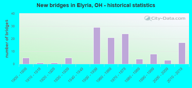
- New bridges - historical statistics
- 51900-1909
- 11910-1919
- 11920-1929
- 51930-1939
- 291950-1959
- 211960-1969
- 241970-1979
- 41980-1989
- 81990-1999
- 32000-2009
- 172010-2019

- Reconstructed bridges - Historical Statistics
- 21960-1969
- 11970-1979
- 111980-1989
- 141990-1999
- 52000-2009
- 12010-2019
- 12020-2022


- Bridge Condition - Deck
- 22.6%Excellent
- 19.0%Very good
- 29.8%Good
- 19.0%Satisfactory
- 7.1%Fair
- 1.2%Poor
- 1.2%Serious

- Bridge Condition - Superstructure
- 22.4%Excellent
- 15.3%Very good
- 35.3%Good
- 16.5%Satisfactory
- 9.4%Fair
- 1.2%Serious

- Bridge Condition - Substructure
- 18.8%Excellent
- 16.5%Very good
- 29.4%Good
- 24.7%Satisfactory
- 10.6%Fair

- Bridge Condition - Channel
- 15.8%Excellent
- 23.7%Very good
- 28.9%Good
- 21.1%Satisfactory
- 7.9%Fair
- 2.6%Poor
Find on map >> Show street view
Structure Number: 4701089, Location: 6.97 MILES EAST OF SR 58 (Lat: 41.320781, Lng: -82.108189), Route carried "on" structure: US 20, Year Built: 1968, Status: Open, Structure Length: 3.69m (12.11ft), Average Daily Traffic: 11,701 (year 2015), Truck Traffic: 11%, Average Future Daily Traffic: 16,241 (year 2035), Design Load: HS 20, Features Intersected: OVER LOR-114-0016 CH
Minimum Vertical Clearance: 30+ m (98+ ft), Kilometerpoint: 21.823, Lanes on structure: 2, Lanes under structure: 2, Base Highway Network: Yes, Owner: State Highway Agency, Approaching Roadway Width: 12.2m (40.0ft), Skew: 1 degrees, Material/Design: Concrete continuous, Design/Construction: Slab, Number Of Spans In Main Unit: 3, Length of Maximum Span: 14.0m (45.9ft), Curb-To-Curb Width: 11.9m (39.0ft), Out-to-Out Width: 12.8m (42.0ft)
Condition: Deck: Satisfactory, Superstructure: Satisfactory, Substructure: Satisfactory, Operating Rating: 61.6 metric tons, Method Used To Determine Operating Rating: Allowable Stress (AS) rating reported by rating factor (RF) method using MS18 loading, Inventory Rating: 35.6 metric tons, Method Used To Determine Inventory Rating: Allowable Stress (AS) rating reported by rating factor (RF) method using MS18 loading, Structural Evaluation: Equal to present minimum criteria, Deck Geometry: Better than present minimum criteria, Underclear: High priority of corrective action, Approach Roadway Alignment: Equal to present desirable criteria, Designated Inspection Frequency: Every 12 months, Inspection Date: November 2021, Deck Structure Type: Concrete Cast-file-Place, Wearing Surface/Protective System: Wearing Surface: Integral Concrete
Find on map >> Show street view
Structure Number: 4701119, Location: 6.97 MILES EAST OF SR 58 (Lat: 41.320589, Lng: -82.108189), Route carried "on" structure: US 20, Year Built: 1968, Status: Open, Structure Length: 3.69m (12.11ft), Average Daily Traffic: 11,701 (year 2015), Truck Traffic: 11%, Average Future Daily Traffic: 16,241 (year 2035), Design Load: HS 20, Features Intersected: OVER LOR-114-0017 CH
Minimum Vertical Clearance: 30+ m (98+ ft), Kilometerpoint: 21.823, Lanes on structure: 2, Lanes under structure: 2, Base Highway Network: Yes, Owner: State Highway Agency, Approaching Roadway Width: 12.2m (40.0ft), Skew: 1 degrees, Material/Design: Concrete continuous, Design/Construction: Slab, Number Of Spans In Main Unit: 3, Length of Maximum Span: 14.0m (45.9ft), Curb-To-Curb Width: 11.9m (39.0ft), Out-to-Out Width: 12.8m (42.0ft)
Condition: Deck: Satisfactory, Superstructure: Satisfactory, Substructure: Fair, Operating Rating: 61.6 metric tons, Method Used To Determine Operating Rating: Allowable Stress (AS) rating reported by rating factor (RF) method using MS18 loading, Inventory Rating: 35.6 metric tons, Method Used To Determine Inventory Rating: Allowable Stress (AS) rating reported by rating factor (RF) method using MS18 loading, Structural Evaluation: Somewhat better than minimum adequacy, Deck Geometry: Better than present minimum criteria, Underclear: Meets minimum limits, Approach Roadway Alignment: Equal to present desirable criteria, Designated Inspection Frequency: Every 12 months, Inspection Date: November 2021, Deck Structure Type: Concrete Cast-file-Place, Wearing Surface/Protective System: Wearing Surface: Integral Concrete
Find on map >> Show street view
Structure Number: 4701143, Location: .77 MILES EAST OF SR 301 (Lat: 41.321881, Lng: -82.103839), Route carried "on" structure: US 20, Year Built: 1968, Status: Open, Structure Length: 4.30m (14.11ft), Average Daily Traffic: 11,701 (year 2015), Truck Traffic: 11%, Average Future Daily Traffic: 16,241 (year 2035), Design Load: HS 20, Features Intersected: OVER B&O RR
Minimum Vertical Clearance: 30+ m (98+ ft), Kilometerpoint: 22.209, Lanes on structure: 2, Base Highway Network: Yes, Owner: State Highway Agency, Approaching Roadway Width: 15.2m (49.9ft), Material/Design: Steel continuous, Design/Construction: Stringer/Multi-beam, Number Of Spans In Main Unit: 3, Length of Maximum Span: 16.2m (53.1ft), Curb-To-Curb Width: 11.7m (38.4ft), Out-to-Out Width: 12.8m (42.0ft)
Condition: Deck: Good, Superstructure: Very good, Substructure: Very good, Operating Rating: 58.3 metric tons, Method Used To Determine Operating Rating: Load and Resistance Factor Rating (LRFR) rating reported by rating factor(RF) method using HL-93 loadings, Inventory Rating: 45.4 metric tons, Method Used To Determine Inventory Rating: Load and Resistance Factor Rating (LRFR) rating reported by rating factor(RF) method using HL-93 loadings, Structural Evaluation: Equal to present desirable criteria, Deck Geometry: Better than present minimum criteria, Underclear: Superior to present desirable criteria, Approach Roadway Alignment: Equal to present desirable criteria, Designated Inspection Frequency: Every 24 months, Inspection Date: November 2021, Deck Structure Type: Concrete Cast-file-Place, Wearing Surface/Protective System: Wearing Surface: Integral Concrete
Find on map >> Show street view
Structure Number: 4701178, Location: .77 MILES EAST OF SR 301 (Lat: 41.321719, Lng: -82.103750), Route carried "on" structure: US 20, Year Built: 1968, Status: Open, Structure Length: 4.30m (14.11ft), Average Daily Traffic: 11,701 (year 2015), Truck Traffic: 11%, Average Future Daily Traffic: 16,241 (year 2035), Design Load: HS 20, Features Intersected: OVER B&O RR
Minimum Vertical Clearance: 30+ m (98+ ft), Kilometerpoint: 22.209, Lanes on structure: 2, Base Highway Network: Yes, Owner: State Highway Agency, Approaching Roadway Width: 15.2m (49.9ft), Material/Design: Steel continuous, Design/Construction: Stringer/Multi-beam, Number Of Spans In Main Unit: 3, Length of Maximum Span: 16.0m (52.5ft), Curb-To-Curb Width: 11.6m (38.1ft), Out-to-Out Width: 12.8m (42.0ft)
Condition: Deck: Satisfactory, Superstructure: Very good, Substructure: Good, Operating Rating: 58.3 metric tons, Method Used To Determine Operating Rating: Load and Resistance Factor Rating (LRFR) rating reported by rating factor(RF) method using HL-93 loadings, Inventory Rating: 45.4 metric tons, Method Used To Determine Inventory Rating: Load and Resistance Factor Rating (LRFR) rating reported by rating factor(RF) method using HL-93 loadings, Structural Evaluation: Better than present minimum criteria, Deck Geometry: Better than present minimum criteria, Underclear: Better than present minimum criteria, Approach Roadway Alignment: Equal to present desirable criteria, Designated Inspection Frequency: Every 12 months, Inspection Date: November 2021, Deck Structure Type: Concrete Cast-file-Place, Wearing Surface/Protective System: Wearing Surface: Integral Concrete
Find on map >> Show street view
Structure Number: 4701208, Location: 1.48 MILES EAST OF SR 301 (Lat: 41.324981, Lng: -82.090769), Route carried "on" structure: US 20, Year Built: 1968, Status: Open, Structure Length: 3.69m (12.11ft), Average Daily Traffic: 11,701 (year 2015), Truck Traffic: 11%, Average Future Daily Traffic: 16,241 (year 2035), Design Load: HS 20, Features Intersected: OVER LOR-026-0016 CH
Minimum Vertical Clearance: 30+ m (98+ ft), Kilometerpoint: 23.352, Lanes on structure: 2, Lanes under structure: 2, Base Highway Network: Yes, Owner: State Highway Agency, Approaching Roadway Width: 15.2m (49.9ft), Skew: 2 degrees, Material/Design: Concrete continuous, Design/Construction: Slab, Number Of Spans In Main Unit: 3, Length of Maximum Span: 14.0m (45.9ft), Curb-To-Curb Width: 11.9m (39.0ft), Out-to-Out Width: 12.8m (42.0ft)
Condition: Deck: Satisfactory, Superstructure: Satisfactory, Substructure: Satisfactory, Operating Rating: 61.6 metric tons, Method Used To Determine Operating Rating: Allowable Stress (AS) rating reported by rating factor (RF) method using MS18 loading, Inventory Rating: 38.9 metric tons, Method Used To Determine Inventory Rating: Allowable Stress (AS) rating reported by rating factor (RF) method using MS18 loading, Structural Evaluation: Equal to present minimum criteria, Deck Geometry: Equal to present minimum criteria, Underclear: Meets minimum limits, Approach Roadway Alignment: Equal to present desirable criteria, Designated Inspection Frequency: Every 12 months, Inspection Date: November 2021, Deck Structure Type: Concrete Cast-file-Place, Wearing Surface/Protective System: Wearing Surface: Integral Concrete
Find on map >> Show street view
Structure Number: 4701232, Location: 1.48 MILES EAST OF SR 301 (Lat: 41.324789, Lng: -82.090761), Route carried "on" structure: US 20, Year Built: 1968, Status: Open, Structure Length: 3.69m (12.11ft), Average Daily Traffic: 11,701 (year 2015), Truck Traffic: 11%, Average Future Daily Traffic: 16,241 (year 2035), Design Load: HS 20, Features Intersected: OVER LOR-026-0017 CH
Minimum Vertical Clearance: 30+ m (98+ ft), Kilometerpoint: 23.352, Lanes on structure: 2, Lanes under structure: 2, Base Highway Network: Yes, Owner: State Highway Agency, Approaching Roadway Width: 15.2m (49.9ft), Skew: 2 degrees, Material/Design: Concrete continuous, Design/Construction: Slab, Number Of Spans In Main Unit: 3, Length of Maximum Span: 14.0m (45.9ft), Curb-To-Curb Width: 11.6m (38.1ft), Out-to-Out Width: 12.8m (42.0ft)
Condition: Deck: Satisfactory, Superstructure: Satisfactory, Substructure: Satisfactory, Operating Rating: 61.6 metric tons, Method Used To Determine Operating Rating: Allowable Stress (AS) rating reported by rating factor (RF) method using MS18 loading, Inventory Rating: 38.9 metric tons, Method Used To Determine Inventory Rating: Allowable Stress (AS) rating reported by rating factor (RF) method using MS18 loading, Structural Evaluation: Equal to present minimum criteria, Deck Geometry: Equal to present minimum criteria, Underclear: High priority of corrective action, Approach Roadway Alignment: Equal to present desirable criteria, Designated Inspection Frequency: Every 12 months, Inspection Date: November 2021, Deck Structure Type: Concrete Cast-file-Place, Wearing Surface/Protective System: Wearing Surface: Integral Concrete
Find on map >> Show street view
Structure Number: 4701267, Location: 8.74 MILES EAST OF SR 58 (Lat: 41.328969, Lng: -82.075939), Route carried "on" structure: US 20, Year Built: 1958, Year Reconstructed: 1997, Status: Open, Structure Length: 5.37m (17.62ft), Average Daily Traffic: 20,320 (year 2015), Truck Traffic: 11%, Average Future Daily Traffic: 28,204 (year 2035), Design Load: HS 20+Mod, Features Intersected: OVER LOR-205-0415 CH
Minimum Vertical Clearance: 30+ m (98+ ft), Kilometerpoint: 24.671, Lanes on structure: 4, Lanes under structure: 4, Base Highway Network: Yes, Owner: State Highway Agency, Approaching Roadway Width: 12.4m (40.7ft), Skew: 32 degrees, Material/Design: Concrete continuous, Design/Construction: Slab, Number Of Spans In Main Unit: 4, Length of Maximum Span: 14.5m (47.6ft), Curb-To-Curb Width: 24.8m (81.4ft), Out-to-Out Width: 26.5m (86.9ft)
Condition: Deck: Good, Superstructure: Good, Substructure: Very good, Operating Rating: 42.1 metric tons, Method Used To Determine Operating Rating: Load Factor (LF) rating reported by rating factor (RF) method using MS18 loading, Inventory Rating: 32.4 metric tons, Method Used To Determine Inventory Rating: Load Factor (LF) rating reported by rating factor (RF) method using MS18 loading, Structural Evaluation: Better than present minimum criteria, Deck Geometry: Superior to present desirable criteria, Underclear: High priority of corrective action, Approach Roadway Alignment: Equal to present desirable criteria, Designated Inspection Frequency: Every 24 months, Inspection Date: December 2021, Deck Structure Type: Concrete Cast-file-Place, Wearing Surface/Protective System: Wearing Surface: Monolithic Concrete, Deck Protection: Epoxy Coated Reinforcing
Find on map >> Show street view
Structure Number: 4701321, Location: 9.00 MILES EAST OF SR 58 (Lat: 41.330531, Lng: -82.071469), Route carried "on" structure: US 20, Year Built: 1958, Year Reconstructed: 1997, Status: Open, Structure Length: 6.48m (21.26ft), Average Daily Traffic: 25,862 (year 2015), Truck Traffic: 10%, Average Future Daily Traffic: 35,896 (year 2035), Design Load: HS 20+Mod, Features Intersected: EAST BRANCH BLACK RIVER
Minimum Vertical Clearance: 30+ m (98+ ft), Kilometerpoint: 25.090, Lanes on structure: 5, Base Highway Network: Yes, Owner: State Highway Agency, Approaching Roadway Width: 16.0m (52.5ft), Skew: 31 degrees, Material/Design: Steel continuous, Design/Construction: Stringer/Multi-beam, Number Of Spans In Main Unit: 3, Length of Maximum Span: 24.4m (80.1ft), Curb-To-Curb Width: 33.3m (109.3ft), Out-to-Out Width: 34.3m (112.5ft)
Condition: Deck: Good, Superstructure: Very good, Substructure: Very good, Channel: Good, Operating Rating: 32.4 metric tons, Method Used To Determine Operating Rating: Load and Resistance Factor Rating (LRFR) rating reported by rating factor(RF) method using HL-93 loadings, Inventory Rating: 25.9 metric tons, Method Used To Determine Inventory Rating: Load and Resistance Factor Rating (LRFR) rating reported by rating factor(RF) method using HL-93 loadings, Structural Evaluation: Equal to present minimum criteria, Deck Geometry: Superior to present desirable criteria, Waterway Adequacy: Superior to present desirable criteria, Approach Roadway Alignment: Equal to present desirable criteria, Designated Inspection Frequency: Every 24 months, Inspection Date: December 2021, Deck Structure Type: Concrete Cast-file-Place, Wearing Surface/Protective System: Wearing Surface: Monolithic Concrete, Deck Protection: Epoxy Coated Reinforcing
Find on map >> Show street view
Structure Number: 470141, Location: .53 MI E OF GRAFTON ROAD (Lat: 41.332589, Lng: -82.066961), Route carried "on" structure: State highway 10, Year Built: 1970, Year Reconstructed: 1997, Status: Open, Structure Length: 8.05m (26.41ft), Average Daily Traffic: 15,529 (year 2015), Truck Traffic: 10%, Average Future Daily Traffic: 21,554 (year 2035), Design Load: HS 20, Features Intersected: OVER LOR-20-1612
Minimum Vertical Clearance: 30+ m (98+ ft), Kilometerpoint: 0.016, Lanes on structure: 2, Lanes under structure: 5, Base Highway Network: Yes, Owner: State Highway Agency, Approaching Roadway Width: 9.8m (32.2ft), Skew: 3 degrees, Material/Design: Steel continuous, Design/Construction: Stringer/Multi-beam, Number Of Spans In Main Unit: 4, Length of Maximum Span: 24.1m (79.1ft), Curb-To-Curb Width: 11.6m (38.1ft), Out-to-Out Width: 12.5m (41.0ft)
Condition: Deck: Very good, Superstructure: Good, Substructure: Satisfactory, Operating Rating: 55.1 metric tons, Method Used To Determine Operating Rating: Load and Resistance Factor Rating (LRFR) rating reported by rating factor(RF) method using HL-93 loadings, Inventory Rating: 42.1 metric tons, Method Used To Determine Inventory Rating: Load and Resistance Factor Rating (LRFR) rating reported by rating factor(RF) method using HL-93 loadings, Structural Evaluation: Equal to present minimum criteria, Deck Geometry: Equal to present minimum criteria, Underclear: High priority of corrective action, Approach Roadway Alignment: Equal to present desirable criteria, Designated Inspection Frequency: Every 12 months, Inspection Date: December 2021, Deck Structure Type: Concrete Cast-file-Place, Wearing Surface/Protective System: Wearing Surface: Monolithic Concrete, Deck Protection: Epoxy Coated Reinforcing
Find on map >> Show street view
Structure Number: 4701968, Location: 5.49 MILES EAST OF SR 58 (Lat: 41.311750, Lng: -82.133169), Route carried "on" structure: US 20, Year Built: 1987, Status: Open, Structure Length: 8.14m (26.71ft), Average Daily Traffic: 7,567 (year 2015), Truck Traffic: 11%, Average Future Daily Traffic: 10,503 (year 2035), Design Load: HS 20+Mod, Features Intersected: WEST BRANCH BLACK RIVER
Minimum Vertical Clearance: 30+ m (98+ ft), Kilometerpoint: 19.441, Lanes on structure: 2, Base Highway Network: Yes, Owner: State Highway Agency, Approaching Roadway Width: 13.4m (44.0ft), Skew: 5 degrees, Material/Design: Steel continuous, Design/Construction: Stringer/Multi-beam, Number Of Spans In Main Unit: 3, Length of Maximum Span: 30.5m (100.1ft), Curb-To-Curb Width: 12.2m (40.0ft), Out-to-Out Width: 12.2m (40.0ft)
Condition: Deck: Very good, Superstructure: Very good, Substructure: Very good, Channel: Good, Operating Rating: 35.6 metric tons, Method Used To Determine Operating Rating: Load and Resistance Factor Rating (LRFR) rating reported by rating factor(RF) method using HL-93 loadings, Inventory Rating: 25.9 metric tons, Method Used To Determine Inventory Rating: Load and Resistance Factor Rating (LRFR) rating reported by rating factor(RF) method using HL-93 loadings, Structural Evaluation: Equal to present minimum criteria, Deck Geometry: Better than present minimum criteria, Waterway Adequacy: Equal to present desirable criteria, Approach Roadway Alignment: Equal to present desirable criteria, Designated Inspection Frequency: Every 24 months, Inspection Date: November 2021, Deck Structure Type: Concrete Cast-file-Place, Wearing Surface/Protective System: Wearing Surface: Bituminous, Deck Protection: Epoxy Coated Reinforcing
Find on map >> Show street view
Structure Number: 4701976, Location: 5.49 MILES EAST OF SR 58 (Lat: 41.311450, Lng: -82.133350), Route carried "on" structure: US 20, Year Built: 1987, Status: Open, Structure Length: 8.14m (26.71ft), Average Daily Traffic: 7,567 (year 2015), Truck Traffic: 11%, Average Future Daily Traffic: 10,503 (year 2035), Design Load: HS 20+Mod, Features Intersected: WEST BRANCH BLACK RIVER
Minimum Vertical Clearance: 30+ m (98+ ft), Kilometerpoint: 19.441, Lanes on structure: 2, Base Highway Network: Yes, Owner: State Highway Agency, Approaching Roadway Width: 13.4m (44.0ft), Skew: 5 degrees, Material/Design: Steel continuous, Design/Construction: Stringer/Multi-beam, Number Of Spans In Main Unit: 3, Length of Maximum Span: 30.5m (100.1ft), Curb-To-Curb Width: 12.2m (40.0ft), Out-to-Out Width: 12.2m (40.0ft)
Condition: Deck: Very good, Superstructure: Very good, Substructure: Very good, Channel: Good, Operating Rating: 35.6 metric tons, Method Used To Determine Operating Rating: Load and Resistance Factor Rating (LRFR) rating reported by rating factor(RF) method using HL-93 loadings, Inventory Rating: 25.9 metric tons, Method Used To Determine Inventory Rating: Load and Resistance Factor Rating (LRFR) rating reported by rating factor(RF) method using HL-93 loadings, Structural Evaluation: Equal to present minimum criteria, Deck Geometry: Better than present minimum criteria, Waterway Adequacy: Equal to present desirable criteria, Approach Roadway Alignment: Equal to present desirable criteria, Designated Inspection Frequency: Every 24 months, Inspection Date: November 2021, Deck Structure Type: Concrete Cast-file-Place, Wearing Surface/Protective System: Wearing Surface: Bituminous, Deck Protection: Epoxy Coated Reinforcing
Find on map >> Show street view
Structure Number: 4702522, Location: .04 MILES SOUTH OF SR 82 (Lat: 41.315111, Lng: -82.069761), Route carried "on" structure: State highway 57, Year Built: 1963, Status: Open, Structure Length: 1.77m (5.81ft), Average Daily Traffic: 10,132 (year 2015), Truck Traffic: 4%, Average Future Daily Traffic: 14,063 (year 2035), Design Load: H 20, Features Intersected: LAKE BRENTWOOD
Minimum Vertical Clearance: 30+ m (98+ ft), Kilometerpoint: 18.910, Lanes on structure: 4, Owner: State Highway Agency, Approaching Roadway Width: 17.4m (57.1ft), Material/Design: Steel, Design/Construction: Stringer/Multi-beam, Number Of Spans In Main Unit: 1, Length of Maximum Span: 16.2m (53.1ft), Curb or Sidewalk Widths: Left: 1.2m (3.9ft), Right: 1.2m (3.9ft), Curb-To-Curb Width: 16.9m (55.4ft), Out-to-Out Width: 20.2m (66.3ft)
Condition: Deck: Good, Superstructure: Satisfactory, Substructure: Satisfactory, Channel: Satisfactory, Operating Rating: 55.1 metric tons, Method Used To Determine Operating Rating: Load and Resistance Factor Rating (LRFR) rating reported by rating factor(RF) method using HL-93 loadings, Inventory Rating: 42.1 metric tons, Method Used To Determine Inventory Rating: Load and Resistance Factor Rating (LRFR) rating reported by rating factor(RF) method using HL-93 loadings, Structural Evaluation: Equal to present minimum criteria, Deck Geometry: Somewhat better than minimum adequacy, Waterway Adequacy: Equal to present desirable criteria, Approach Roadway Alignment: Equal to present desirable criteria, Designated Inspection Frequency: Every 12 months, Inspection Date: August 2021, Deck Structure Type: Concrete Cast-file-Place, Wearing Surface/Protective System: Wearing Surface: Integral Concrete
Find on map >> Show street view
Structure Number: 4702581, Location: .75 MI NORTH OF SR 82 (Lat: 41.326811, Lng: -82.069161), Route carried "on" structure: State highway 57, Year Built: 1963, Year Reconstructed: 2011, Status: Open, Structure Length: 3.63m (11.91ft), Average Daily Traffic: 6,270 (year 2015), Truck Traffic: 6%, Average Future Daily Traffic: 8,703 (year 2035), Design Load: HS 20+Mod, Features Intersected: BRANCH OF BLACK RIVER
Minimum Vertical Clearance: 30+ m (98+ ft), Kilometerpoint: 20.181, Lanes on structure: 2, Owner: State Highway Agency, Approaching Roadway Width: 12.8m (42.0ft), Material/Design: Concrete continuous, Design/Construction: Slab, Number Of Spans In Main Unit: 3, Length of Maximum Span: 13.7m (44.9ft), Curb-To-Curb Width: 12.2m (40.0ft), Out-to-Out Width: 12.2m (40.0ft)
Condition: Deck: Excellent, Superstructure: Excellent, Substructure: Very good, Channel: Good, Operating Rating: 51.8 metric tons, Method Used To Determine Operating Rating: Load and Resistance Factor Rating (LRFR) rating reported by rating factor(RF) method using HL-93 loadings, Inventory Rating: 42.1 metric tons, Method Used To Determine Inventory Rating: Load and Resistance Factor Rating (LRFR) rating reported by rating factor(RF) method using HL-93 loadings, Structural Evaluation: Equal to present desirable criteria, Deck Geometry: Better than present minimum criteria, Waterway Adequacy: Superior to present desirable criteria, Approach Roadway Alignment: Equal to present desirable criteria, Designated Inspection Frequency: Every 24 months, Inspection Date: August 2021, Deck Structure Type: Concrete Cast-file-Place, Wearing Surface/Protective System: Wearing Surface: Monolithic Concrete, Deck Protection: Epoxy Coated Reinforcing
Find on map >> Show street view
Structure Number: 4702611, Location: .75 MI NORTH OF SR 82 (Lat: 41.326650, Lng: -82.068850), Route carried "on" structure: State highway 57, Year Built: 1963, Year Reconstructed: 2011, Status: Open, Structure Length: 3.63m (11.91ft), Average Daily Traffic: 6,270 (year 2015), Truck Traffic: 6%, Average Future Daily Traffic: 8,703 (year 2035), Design Load: HS 20+Mod, Features Intersected: BRANCH OF BLACK RIVER
Minimum Vertical Clearance: 30+ m (98+ ft), Kilometerpoint: 20.181, Lanes on structure: 2, Owner: State Highway Agency, Approaching Roadway Width: 12.8m (42.0ft), Material/Design: Concrete continuous, Design/Construction: Slab, Number Of Spans In Main Unit: 3, Length of Maximum Span: 13.7m (44.9ft), Curb-To-Curb Width: 12.2m (40.0ft), Out-to-Out Width: 12.2m (40.0ft)
Condition: Deck: Excellent, Superstructure: Excellent, Substructure: Good, Channel: Good, Operating Rating: 55.1 metric tons, Method Used To Determine Operating Rating: Load and Resistance Factor Rating (LRFR) rating reported by rating factor(RF) method using HL-93 loadings, Inventory Rating: 42.1 metric tons, Method Used To Determine Inventory Rating: Load and Resistance Factor Rating (LRFR) rating reported by rating factor(RF) method using HL-93 loadings, Structural Evaluation: Better than present minimum criteria, Deck Geometry: Better than present minimum criteria, Waterway Adequacy: Superior to present desirable criteria, Approach Roadway Alignment: Equal to present desirable criteria, Designated Inspection Frequency: Every 24 months, Inspection Date: August 2021, Deck Structure Type: Concrete Cast-file-Place, Wearing Surface/Protective System: Wearing Surface: Monolithic Concrete, Deck Protection: Epoxy Coated Reinforcing
Find on map >> Show street view
Structure Number: 470267, Location: 12.56 MILES EAST OF SR 58 (Lat: 41.374150, Lng: -82.076031), Route carried "on" structure: US 20, Year Built: 1963, Status: Open, Structure Length: 10.45m (34.28ft), Average Daily Traffic: 16,184 (year 2015), Truck Traffic: 5%, Average Future Daily Traffic: 22,463 (year 2035), Design Load: H 15, Features Intersected: OVER N&S RR YARDS
Minimum Vertical Clearance: 30+ m (98+ ft), Kilometerpoint: 30.819, Lanes on structure: 2, Base Highway Network: Yes, Owner: State Highway Agency, Approaching Roadway Width: 11.3m (37.1ft), Material/Design: Steel continuous, Design/Construction: Stringer/Multi-beam, Number Of Spans In Main Unit: 6, Length of Maximum Span: 19.5m (64.0ft), Curb-To-Curb Width: 11.4m (37.4ft), Out-to-Out Width: 12.4m (40.7ft)
Condition: Deck: Good, Superstructure: Good, Substructure: Satisfactory, Operating Rating: 45.4 metric tons, Method Used To Determine Operating Rating: Load and Resistance Factor Rating (LRFR) rating reported by rating factor(RF) method using HL-93 loadings, Inventory Rating: 35.6 metric tons, Method Used To Determine Inventory Rating: Load and Resistance Factor Rating (LRFR) rating reported by rating factor(RF) method using HL-93 loadings, Structural Evaluation: Equal to present minimum criteria, Deck Geometry: Equal to present minimum criteria, Underclear: Meets minimum limits, Approach Roadway Alignment: Equal to present desirable criteria, Length Of Structure Improvement: 30.48m (100.00ft), Designated Inspection Frequency: Every 12 months, Inspection Date: August 2021, Bridge Improvement Cost: $13,000, Roadway Improvement Cost: $1,000, Total Project Cost: $15,000, Deck Structure Type: Concrete Cast-file-Place, Wearing Surface/Protective System: Wearing Surface: Integral Concrete
Find on map >> Show street view
Structure Number: 47027, Location: 12.56 MILES EAST OF SR 58 (Lat: 41.374200, Lng: -82.075850), Route carried "on" structure: US 20, Year Built: 1963, Status: Open, Structure Length: 10.45m (34.28ft), Average Daily Traffic: 16,184 (year 2015), Truck Traffic: 5%, Average Future Daily Traffic: 22,463 (year 2035), Design Load: H 15, Features Intersected: OVER N&S RR YARDS
Minimum Vertical Clearance: 30+ m (98+ ft), Kilometerpoint: 30.819, Lanes on structure: 2, Base Highway Network: Yes, Owner: State Highway Agency, Approaching Roadway Width: 11.3m (37.1ft), Material/Design: Steel continuous, Design/Construction: Stringer/Multi-beam, Number Of Spans In Main Unit: 6, Length of Maximum Span: 19.5m (64.0ft), Curb-To-Curb Width: 11.4m (37.4ft), Out-to-Out Width: 12.4m (40.7ft)
Condition: Deck: Good, Superstructure: Good, Substructure: Satisfactory, Operating Rating: 45.4 metric tons, Method Used To Determine Operating Rating: Load and Resistance Factor Rating (LRFR) rating reported by rating factor(RF) method using HL-93 loadings, Inventory Rating: 35.6 metric tons, Method Used To Determine Inventory Rating: Load and Resistance Factor Rating (LRFR) rating reported by rating factor(RF) method using HL-93 loadings, Structural Evaluation: Equal to present minimum criteria, Deck Geometry: Equal to present minimum criteria, Underclear: Meets minimum limits, Approach Roadway Alignment: Equal to present desirable criteria, Length Of Structure Improvement: 30.48m (100.00ft), Designated Inspection Frequency: Every 12 months, Inspection Date: August 2021, Bridge Improvement Cost: $13,000, Roadway Improvement Cost: $1,000, Total Project Cost: $15,000, Deck Structure Type: Concrete Cast-file-Place, Wearing Surface/Protective System: Wearing Surface: Integral Concrete
Find on map >> Show street view
Structure Number: 4702832, Location: 1.8 MI.S.OF OH.TURNPIKE (Lat: 41.383389, Lng: -82.102900), Route carried "on" structure: State highway 57, Year Built: 2004, Status: Open, Structure Length: 14.52m (47.64ft), Average Daily Traffic: 21,990 (year 2015), Truck Traffic: 5%, Average Future Daily Traffic: 30,522 (year 2035), Design Load: HS 25 or greater, Features Intersected: BLACK RIVER
Minimum Vertical Clearance: 30+ m (98+ ft), Kilometerpoint: 29.258, Lanes on structure: 6, Base Highway Network: Yes, Owner: State Highway Agency, Approaching Roadway Width: 11.6m (38.1ft), Skew: 32 degrees, Material/Design: Prestressed concrete continuous, Design/Construction: Stringer/Multi-beam, Number Of Spans In Main Unit: 4, Length of Maximum Span: 48.2m (158.1ft), Curb-To-Curb Width: 29.9m (98.1ft), Out-to-Out Width: 31.5m (103.3ft)
Condition: Deck: Very good, Superstructure: Very good, Substructure: Very good, Channel: Excellent, Operating Rating: 42.1 metric tons, Method Used To Determine Operating Rating: Load Factor (LF) rating reported by rating factor (RF) method using MS18 loading, Inventory Rating: 32.4 metric tons, Method Used To Determine Inventory Rating: Load Factor (LF) rating reported by rating factor (RF) method using MS18 loading, Structural Evaluation: Equal to present desirable criteria, Deck Geometry: Superior to present desirable criteria, Waterway Adequacy: Superior to present desirable criteria, Approach Roadway Alignment: Equal to present desirable criteria, Designated Inspection Frequency: Every 24 months, Inspection Date: July 2021, Deck Structure Type: Concrete Cast-file-Place, Wearing Surface/Protective System: Wearing Surface: Monolithic Concrete, Deck Protection: Epoxy Coated Reinforcing
Find on map >> Show street view
Structure Number: 4703456, Location: 9.28 MILES EAST OF SR 58 (Lat: 41.332419, Lng: -82.066889), Route carried "on" structure: US 20, Year Built: 1963, Year Reconstructed: 1997, Status: Open, Structure Length: 8.05m (26.41ft), Average Daily Traffic: 25,862 (year 2015), Truck Traffic: 10%, Average Future Daily Traffic: 35,896 (year 2035), Design Load: HS 20+Mod, Features Intersected: OVER LOR-20-1610
Minimum Vertical Clearance: 30+ m (98+ ft), Kilometerpoint: 25.540, Lanes on structure: 3, Lanes under structure: 7, Base Highway Network: Yes, Owner: State Highway Agency, Approaching Roadway Width: 15.2m (49.9ft), Skew: 3 degrees, Material/Design: Steel continuous, Design/Construction: Stringer/Multi-beam, Number Of Spans In Main Unit: 4, Length of Maximum Span: 25.1m (82.3ft), Curb-To-Curb Width: 15.2m (49.9ft), Out-to-Out Width: 16.3m (53.5ft)
Condition: Deck: Very good, Superstructure: Good, Substructure: Good, Operating Rating: 71.3 metric tons, Method Used To Determine Operating Rating: Load and Resistance Factor Rating (LRFR) rating reported by rating factor(RF) method using HL-93 loadings, Inventory Rating: 55.1 metric tons, Method Used To Determine Inventory Rating: Load and Resistance Factor Rating (LRFR) rating reported by rating factor(RF) method using HL-93 loadings, Structural Evaluation: Better than present minimum criteria, Deck Geometry: Meets minimum limits, Underclear: Meets minimum limits, Approach Roadway Alignment: Equal to present desirable criteria, Designated Inspection Frequency: Every 24 months, Inspection Date: December 2021, Deck Structure Type: Concrete Cast-file-Place, Wearing Surface/Protective System: Wearing Surface: Monolithic Concrete, Deck Protection: Epoxy Coated Reinforcing
Find on map >> Show street view
Structure Number: 4704355, Location: .48 MILES EAST OF SR 2 (Lat: 41.403950, Lng: -82.132319), Route carried "on" structure: Interstate 90, Year Built: 1967, Year Reconstructed: 2009, Status: Open, Structure Length: 5.08m (16.67ft), Average Daily Traffic: 31,861 (year 2015), Truck Traffic: 28%, Average Future Daily Traffic: 44,223 (year 2035), Design Load: HS 25 or greater, Features Intersected: OVER LAKE AVE CH-204
Minimum Vertical Clearance: 30+ m (98+ ft), Kilometerpoint: 20.020, Lanes on structure: 2, Lanes under structure: 4, Base Highway Network: Yes, Owner: State Highway Agency, Approaching Roadway Width: 18.3m (60.0ft), Skew: 1 degrees, Material/Design: Steel continuous, Design/Construction: Stringer/Multi-beam, Number Of Spans In Main Unit: 3, Length of Maximum Span: 20.9m (68.6ft), Curb-To-Curb Width: 18.3m (60.0ft), Out-to-Out Width: 19.2m (63.0ft)
Condition: Deck: Excellent, Superstructure: Excellent, Substructure: Excellent, Operating Rating: 68.0 metric tons, Method Used To Determine Operating Rating: Load and Resistance Factor Rating (LRFR) rating reported by rating factor(RF) method using HL-93 loadings, Inventory Rating: 51.8 metric tons, Method Used To Determine Inventory Rating: Load and Resistance Factor Rating (LRFR) rating reported by rating factor(RF) method using HL-93 loadings, Structural Evaluation: Superior to present desirable criteria, Deck Geometry: Superior to present desirable criteria, Underclear: High priority of corrective action, Approach Roadway Alignment: Equal to present desirable criteria, Designated Inspection Frequency: Every 24 months, Inspection Date: December 2021, Deck Structure Type: Concrete Cast-file-Place, Wearing Surface/Protective System: Wearing Surface: Monolithic Concrete, Deck Protection: Epoxy Coated Reinforcing
Find on map >> Show street view
Structure Number: 4704371, Location: 2.09 MI EAST OF ERIE CO (Lat: 41.402650, Lng: -82.149031), Route carried "on" structure: Interstate 90, Year Built: 1974, Status: Open, Structure Length: 3.72m (12.20ft), Average Daily Traffic: 3,911 (year 2015), Truck Traffic: 28%, Average Future Daily Traffic: 5,428 (year 2035), Design Load: HS 20+Mod, Features Intersected: OVER LOR-54-0514 TH-54
Minimum Vertical Clearance: 30+ m (98+ ft), Kilometerpoint: 18.620, Lanes on structure: 2, Lanes under structure: 2, Base Highway Network: Yes, Owner: State Highway Agency, Approaching Roadway Width: 12.8m (42.0ft), Skew: 2 degrees, Material/Design: Steel continuous, Design/Construction: Stringer/Multi-beam, Number Of Spans In Main Unit: 3, Length of Maximum Span: 15.2m (49.9ft), Curb-To-Curb Width: 12.3m (40.4ft), Out-to-Out Width: 12.8m (42.0ft)
Condition: Deck: Poor, Superstructure: Good, Substructure: Good, Operating Rating: 38.9 metric tons, Method Used To Determine Operating Rating: Load and Resistance Factor Rating (LRFR) rating reported by rating factor(RF) method using HL-93 loadings, Inventory Rating: 29.2 metric tons, Method Used To Determine Inventory Rating: Load and Resistance Factor Rating (LRFR) rating reported by rating factor(RF) method using HL-93 loadings, Structural Evaluation: Better than present minimum criteria, Deck Geometry: Better than present minimum criteria, Underclear: Somewhat better than minimum adequacy, Approach Roadway Alignment: Equal to present desirable criteria, Designated Inspection Frequency: Every 12 months, Inspection Date: November 2021, Deck Structure Type: Concrete Cast-file-Place, Wearing Surface/Protective System: Wearing Surface: Bituminous
Find on map >> Show street view
Structure Number: 4704398, Location: 2.09 MI EAST OF ERIE CO (Lat: 41.402981, Lng: -82.149031), Route carried "on" structure: Interstate 90, Year Built: 1974, Status: Open, Structure Length: 3.93m (12.89ft), Average Daily Traffic: 3,911 (year 2015), Truck Traffic: 28%, Average Future Daily Traffic: 5,428 (year 2035), Design Load: HS 20+Mod, Features Intersected: OVER LOR-54-0514 TH-54
Minimum Vertical Clearance: 30+ m (98+ ft), Kilometerpoint: 18.620, Lanes on structure: 2, Lanes under structure: 2, Base Highway Network: Yes, Owner: State Highway Agency, Approaching Roadway Width: 12.8m (42.0ft), Skew: 2 degrees, Material/Design: Steel continuous, Design/Construction: Stringer/Multi-beam, Number Of Spans In Main Unit: 3, Length of Maximum Span: 15.5m (50.9ft), Curb-To-Curb Width: 12.2m (40.0ft), Out-to-Out Width: 13.4m (44.0ft)
Condition: Deck: Fair, Superstructure: Good, Substructure: Good, Operating Rating: 48.6 metric tons, Method Used To Determine Operating Rating: Load and Resistance Factor Rating (LRFR) rating reported by rating factor(RF) method using HL-93 loadings, Inventory Rating: 35.6 metric tons, Method Used To Determine Inventory Rating: Load and Resistance Factor Rating (LRFR) rating reported by rating factor(RF) method using HL-93 loadings, Structural Evaluation: Better than present minimum criteria, Deck Geometry: Better than present minimum criteria, Underclear: Somewhat better than minimum adequacy, Approach Roadway Alignment: Equal to present desirable criteria, Designated Inspection Frequency: Every 12 months, Inspection Date: November 2021, Deck Structure Type: Concrete Cast-file-Place, Wearing Surface/Protective System: Wearing Surface: Bituminous
Find on map >> Show street view
Structure Number: 4704401, Location: 2.38 MI E OF OHIO TRNPK (Lat: 41.403919, Lng: -82.145239), Route carried "on" structure: Interstate 90, Year Built: 1974, Year Reconstructed: 2019, Status: Open, Structure Length: 6.92m (22.70ft), Average Daily Traffic: 7,000 (year 2019), Truck Traffic: 31%, Average Future Daily Traffic: 9,716 (year 2039), Design Load: HL 93, Features Intersected: OVER LOR-002-1169R
Minimum Vertical Clearance: 30+ m (98+ ft), Kilometerpoint: 18.958, Lanes on structure: 2, Lanes under structure: 2, Base Highway Network: Yes, Owner: State Highway Agency, Approaching Roadway Width: 12.8m (42.0ft), Skew: 5 degrees, Material/Design: Steel continuous, Design/Construction: Stringer/Multi-beam, Number Of Spans In Main Unit: 3, Length of Maximum Span: 28.3m (92.8ft), Curb-To-Curb Width: 12.5m (41.0ft), Out-to-Out Width: 13.4m (44.0ft)
Condition: Deck: Excellent, Superstructure: Excellent, Substructure: Excellent, Operating Rating: 84.2 metric tons, Method Used To Determine Operating Rating: Load and Resistance Factor Rating (LRFR) rating reported by rating factor(RF) method using HL-93 loadings, Inventory Rating: 64.8 metric tons, Method Used To Determine Inventory Rating: Load and Resistance Factor Rating (LRFR) rating reported by rating factor(RF) method using HL-93 loadings, Structural Evaluation: Superior to present desirable criteria, Deck Geometry: Better than present minimum criteria, Underclear: Somewhat better than minimum adequacy, Approach Roadway Alignment: Equal to present desirable criteria, Designated Inspection Frequency: Every 12 months, Inspection Date: December 2021, Deck Structure Type: Concrete Cast-file-Place, Wearing Surface/Protective System: Wearing Surface: Monolithic Concrete, Membrane: Other, Deck Protection: Epoxy Coated Reinforcing
Find on map >> Show street view
Structure Number: 4704444, Location: .48 MILES EAST OF SR 2 (Lat: 41.403669, Lng: -82.132200), Route carried "on" structure: Interstate 90, Year Built: 1967, Year Reconstructed: 2009, Status: Open, Structure Length: 4.97m (16.31ft), Average Daily Traffic: 31,861 (year 2015), Truck Traffic: 28%, Average Future Daily Traffic: 44,223 (year 2035), Design Load: HS 25 or greater, Features Intersected: OVER LAKE AVE CH-204
Minimum Vertical Clearance: 30+ m (98+ ft), Kilometerpoint: 20.020, Lanes on structure: 2, Lanes under structure: 4, Base Highway Network: Yes, Owner: State Highway Agency, Approaching Roadway Width: 18.3m (60.0ft), Skew: 1 degrees, Material/Design: Steel continuous, Design/Construction: Stringer/Multi-beam, Number Of Spans In Main Unit: 3, Length of Maximum Span: 20.4m (66.9ft), Curb-To-Curb Width: 18.3m (60.0ft), Out-to-Out Width: 19.2m (63.0ft)
Condition: Deck: Excellent, Superstructure: Excellent, Substructure: Excellent, Operating Rating: 71.3 metric tons, Method Used To Determine Operating Rating: Load and Resistance Factor Rating (LRFR) rating reported by rating factor(RF) method using HL-93 loadings, Inventory Rating: 55.1 metric tons, Method Used To Determine Inventory Rating: Load and Resistance Factor Rating (LRFR) rating reported by rating factor(RF) method using HL-93 loadings, Structural Evaluation: Superior to present desirable criteria, Deck Geometry: Superior to present desirable criteria, Underclear: High priority of corrective action, Approach Roadway Alignment: Equal to present desirable criteria, Designated Inspection Frequency: Every 24 months, Inspection Date: December 2021, Deck Structure Type: Concrete Cast-file-Place, Wearing Surface/Protective System: Wearing Surface: Monolithic Concrete, Deck Protection: Epoxy Coated Reinforcing
Find on map >> Show street view
Structure Number: 4704487, Location: .60 MILES EAST OF SR 2 (Lat: 41.404111, Lng: -82.130039), Route carried "on" structure: Interstate 90, Year Built: 2009, Status: Open, Structure Length: 4.42m (14.50ft), Average Daily Traffic: 31,861 (year 2015), Truck Traffic: 28%, Average Future Daily Traffic: 44,223 (year 2035), Design Load: HS 25 or greater, Features Intersected: OVER CSX RR
Minimum Vertical Clearance: 30+ m (98+ ft), Kilometerpoint: 20.213, Lanes on structure: 2, Base Highway Network: Yes, Owner: State Highway Agency, Approaching Roadway Width: 19.2m (63.0ft), Material/Design: Steel continuous, Design/Construction: Stringer/Multi-beam, Number Of Spans In Main Unit: 3, Length of Maximum Span: 17.4m (57.1ft), Curb-To-Curb Width: 18.3m (60.0ft), Out-to-Out Width: 19.2m (63.0ft)
Condition: Deck: Excellent, Superstructure: Excellent, Substructure: Excellent, Operating Rating: 68.0 metric tons, Method Used To Determine Operating Rating: Load and Resistance Factor Rating (LRFR) rating reported by rating factor(RF) method using HL-93 loadings, Inventory Rating: 51.8 metric tons, Method Used To Determine Inventory Rating: Load and Resistance Factor Rating (LRFR) rating reported by rating factor(RF) method using HL-93 loadings, Structural Evaluation: Superior to present desirable criteria, Deck Geometry: Superior to present desirable criteria, Underclear: Meets minimum limits, Approach Roadway Alignment: Equal to present desirable criteria, Designated Inspection Frequency: Every 24 months, Inspection Date: December 2021, Deck Structure Type: Concrete Cast-file-Place, Wearing Surface/Protective System: Wearing Surface: Monolithic Concrete, Deck Protection: Epoxy Coated Reinforcing
Find on map >> Show street view
Structure Number: 4704517, Location: .60 MILES EAST OF SR 2 (Lat: 41.403831, Lng: -82.129939), Route carried "on" structure: Interstate 90, Year Built: 2009, Status: Open, Structure Length: 4.42m (14.50ft), Average Daily Traffic: 31,861 (year 2015), Truck Traffic: 28%, Average Future Daily Traffic: 44,223 (year 2035), Design Load: HS 25 or greater, Features Intersected: OVER CSX RR
Minimum Vertical Clearance: 30+ m (98+ ft), Kilometerpoint: 20.213, Lanes on structure: 2, Base Highway Network: Yes, Owner: State Highway Agency, Approaching Roadway Width: 19.2m (63.0ft), Material/Design: Steel continuous, Design/Construction: Stringer/Multi-beam, Number Of Spans In Main Unit: 3, Length of Maximum Span: 17.4m (57.1ft), Curb-To-Curb Width: 18.3m (60.0ft), Out-to-Out Width: 19.2m (63.0ft)
Condition: Deck: Excellent, Superstructure: Excellent, Substructure: Excellent, Operating Rating: 68.0 metric tons, Method Used To Determine Operating Rating: Load and Resistance Factor Rating (LRFR) rating reported by rating factor(RF) method using HL-93 loadings, Inventory Rating: 51.8 metric tons, Method Used To Determine Inventory Rating: Load and Resistance Factor Rating (LRFR) rating reported by rating factor(RF) method using HL-93 loadings, Structural Evaluation: Superior to present desirable criteria, Deck Geometry: Superior to present desirable criteria, Underclear: Meets minimum limits, Approach Roadway Alignment: Equal to present desirable criteria, Designated Inspection Frequency: Every 24 months, Inspection Date: December 2021, Deck Structure Type: Concrete Cast-file-Place, Wearing Surface/Protective System: Wearing Surface: Monolithic Concrete, Deck Protection: Epoxy Coated Reinforcing
Find on map >> Show street view
Structure Number: 4704665, Location: 1.06 MILES EAST OF SR 57 (Lat: 41.410619, Lng: -82.100400), Route carried "on" structure: Interstate 90, Year Built: 2013, Status: Open, Structure Length: 11.06m (36.29ft), Average Daily Traffic: 25,861 (year 2015), Truck Traffic: 28%, Average Future Daily Traffic: 35,895 (year 2035), Design Load: HL 93, Features Intersected: OVER BLACK RIVER/PARK RD
Minimum Vertical Clearance: 30+ m (98+ ft), Kilometerpoint: 22.949, Lanes on structure: 2, Base Highway Network: Yes, Owner: State Highway Agency, Approaching Roadway Width: 18.9m (62.0ft), Material/Design: Prestressed concrete continuous, Design/Construction: Stringer/Multi-beam, Number Of Spans In Main Unit: 3, Length of Maximum Span: 42.7m (140.1ft), Curb-To-Curb Width: 19.5m (64.0ft), Out-to-Out Width: 20.4m (66.9ft)
Condition: Deck: Excellent, Superstructure: Excellent, Substructure: Excellent, Channel: Excellent, Operating Rating: 74.5 metric tons, Method Used To Determine Operating Rating: Load and Resistance Factor Rating (LRFR) rating reported by rating factor(RF) method using HL-93 loadings, Inventory Rating: 29.2 metric tons, Method Used To Determine Inventory Rating: Load and Resistance Factor Rating (LRFR) rating reported by rating factor(RF) method using HL-93 loadings, Structural Evaluation: Better than present minimum criteria, Deck Geometry: Superior to present desirable criteria, Waterway Adequacy: Equal to present desirable criteria, Approach Roadway Alignment: Equal to present desirable criteria, Designated Inspection Frequency: Every 24 months, Inspection Date: December 2021, Deck Structure Type: Concrete Cast-file-Place, Wearing Surface/Protective System: Wearing Surface: Monolithic Concrete, Deck Protection: Epoxy Coated Reinforcing
Find on map >> Show street view
Structure Number: 4704703, Location: 1.06 MILES EAST OF SR 57 (Lat: 41.410569, Lng: -82.100100), Route carried "on" structure: Interstate 90, Year Built: 2013, Status: Open, Structure Length: 11.06m (36.29ft), Average Daily Traffic: 25,861 (year 2015), Truck Traffic: 28%, Average Future Daily Traffic: 35,895 (year 2035), Design Load: HL 93, Features Intersected: OVER BLACK RIVER/PARK RD
Minimum Vertical Clearance: 30+ m (98+ ft), Kilometerpoint: 22.949, Lanes on structure: 2, Base Highway Network: Yes, Owner: State Highway Agency, Approaching Roadway Width: 18.9m (62.0ft), Material/Design: Prestressed concrete continuous, Design/Construction: Stringer/Multi-beam, Number Of Spans In Main Unit: 3, Length of Maximum Span: 42.7m (140.1ft), Curb-To-Curb Width: 19.5m (64.0ft), Out-to-Out Width: 20.4m (66.9ft)
Condition: Deck: Excellent, Superstructure: Excellent, Substructure: Excellent, Channel: Excellent, Operating Rating: 74.5 metric tons, Method Used To Determine Operating Rating: Load and Resistance Factor Rating (LRFR) rating reported by rating factor(RF) method using HL-93 loadings, Inventory Rating: 68.0 metric tons, Method Used To Determine Inventory Rating: Load and Resistance Factor Rating (LRFR) rating reported by rating factor(RF) method using HL-93 loadings, Structural Evaluation: Superior to present desirable criteria, Deck Geometry: Superior to present desirable criteria, Waterway Adequacy: Equal to present desirable criteria, Approach Roadway Alignment: Equal to present desirable criteria, Designated Inspection Frequency: Every 24 months, Inspection Date: December 2021, Deck Structure Type: Concrete Cast-file-Place, Wearing Surface/Protective System: Wearing Surface: Monolithic Concrete, Deck Protection: Epoxy Coated Reinforcing
Find on map >> Show street view
Structure Number: 4704738, Location: 1.23 MILES EAST OF SR 57 (Lat: 41.412781, Lng: -82.098900), Route carried "on" structure: Interstate 90, Year Built: 2013, Status: Open, Structure Length: 4.62m (15.16ft), Average Daily Traffic: 25,861 (year 2015), Truck Traffic: 28%, Average Future Daily Traffic: 35,895 (year 2035), Design Load: HL 93, Features Intersected: OVER FORD ROAD TH-108
Minimum Vertical Clearance: 30+ m (98+ ft), Kilometerpoint: 23.223, Lanes on structure: 2, Lanes under structure: 2, Base Highway Network: Yes, Owner: State Highway Agency, Approaching Roadway Width: 18.9m (62.0ft), Material/Design: Steel continuous, Design/Construction: Stringer/Multi-beam, Number Of Spans In Main Unit: 3, Length of Maximum Span: 19.5m (64.0ft), Curb-To-Curb Width: 18.9m (62.0ft), Out-to-Out Width: 19.8m (65.0ft)
Condition: Deck: Excellent, Superstructure: Excellent, Substructure: Excellent, Channel: Excellent, Operating Rating: 61.6 metric tons, Method Used To Determine Operating Rating: Load and Resistance Factor Rating (LRFR) rating reported by rating factor(RF) method using HL-93 loadings, Inventory Rating: 48.6 metric tons, Method Used To Determine Inventory Rating: Load and Resistance Factor Rating (LRFR) rating reported by rating factor(RF) method using HL-93 loadings, Structural Evaluation: Superior to present desirable criteria, Deck Geometry: Superior to present desirable criteria, Underclear: High priority of corrective action, Approach Roadway Alignment: Equal to present desirable criteria, Designated Inspection Frequency: Every 24 months, Inspection Date: December 2021, Deck Structure Type: Concrete Cast-file-Place, Wearing Surface/Protective System: Wearing Surface: Monolithic Concrete, Deck Protection: Epoxy Coated Reinforcing
Find on map >> Show street view
Structure Number: 4704754, Location: 1.23 MILES EAST OF SR 57 (Lat: 41.412619, Lng: -82.098569), Route carried "on" structure: Interstate 90, Year Built: 2013, Status: Open, Structure Length: 5.46m (17.91ft), Average Daily Traffic: 25,861 (year 2015), Truck Traffic: 28%, Average Future Daily Traffic: 35,895 (year 2035), Design Load: HL 93, Features Intersected: OVER FORD ROAD TH-108
Minimum Vertical Clearance: 30+ m (98+ ft), Kilometerpoint: 23.223, Lanes on structure: 2, Lanes under structure: 2, Base Highway Network: Yes, Owner: State Highway Agency, Approaching Roadway Width: 18.9m (62.0ft), Material/Design: Steel continuous, Design/Construction: Stringer/Multi-beam, Number Of Spans In Main Unit: 3, Length of Maximum Span: 22.4m (73.5ft), Curb-To-Curb Width: 18.9m (62.0ft), Out-to-Out Width: 19.8m (65.0ft)
Condition: Deck: Excellent, Superstructure: Excellent, Substructure: Excellent, Operating Rating: 42.1 metric tons, Method Used To Determine Operating Rating: Load and Resistance Factor Rating (LRFR) rating reported by rating factor(RF) method using HL-93 loadings, Inventory Rating: 32.4 metric tons, Method Used To Determine Inventory Rating: Load and Resistance Factor Rating (LRFR) rating reported by rating factor(RF) method using HL-93 loadings, Structural Evaluation: Equal to present desirable criteria, Deck Geometry: Superior to present desirable criteria, Underclear: High priority of corrective action, Approach Roadway Alignment: Equal to present desirable criteria, Designated Inspection Frequency: Every 24 months, Inspection Date: December 2021, Deck Structure Type: Concrete Cast-file-Place, Wearing Surface/Protective System: Wearing Surface: Monolithic Concrete, Deck Protection: Epoxy Coated Reinforcing
Find on map >> Show street view
Structure Number: 4704789, Location: 1.58 MI.EAST OF SR 57 (Lat: 41.415489, Lng: -82.092950), Route carried "on" structure: County highway C0017, Year Built: 2011, Status: Open, Structure Length: 9.42m (30.91ft), Average Daily Traffic: 8,902 (year 2015), Truck Traffic: 2%, Average Future Daily Traffic: 71,790 (year 2035), Design Load: HL 93, Features Intersected: OVER LOR-90-14.78, Facility Carried by Structure: CR 17 GULF ROAD
Minimum Vertical Clearance: 30+ m (98+ ft), Kilometerpoint: 5.423, Lanes on structure: 2, Lanes under structure: 4, Owner: State Highway Agency, Approaching Roadway Width: 9.8m (32.2ft), Skew: 1 degrees, Material/Design: Steel continuous, Design/Construction: Stringer/Multi-beam, Number Of Spans In Main Unit: 4, Length of Maximum Span: 27.1m (88.9ft), Curb or Sidewalk Widths: Left: 1.5m (4.9ft), Right: 1.5m (4.9ft), Curb-To-Curb Width: 9.1m (29.9ft), Out-to-Out Width: 12.8m (42.0ft)
Condition: Deck: Excellent, Superstructure: Excellent, Substructure: Excellent, Operating Rating: 71.3 metric tons, Method Used To Determine Operating Rating: Load and Resistance Factor Rating (LRFR) rating reported by rating factor(RF) method using HL-93 loadings, Inventory Rating: 55.1 metric tons, Method Used To Determine Inventory Rating: Load and Resistance Factor Rating (LRFR) rating reported by rating factor(RF) method using HL-93 loadings, Structural Evaluation: Superior to present desirable criteria, Deck Geometry: Meets minimum limits, Underclear: High priority of corrective action, Approach Roadway Alignment: Equal to present desirable criteria, Designated Inspection Frequency: Every 24 months, Inspection Date: December 2021, Deck Structure Type: Concrete Cast-file-Place, Wearing Surface/Protective System: Wearing Surface: Monolithic Concrete, Deck Protection: Epoxy Coated Reinforcing
Find on map >> Show street view
Structure Number: 4705491, Location: 3.13 MILES EAST OF SR 58 (Lat: 41.378781, Lng: -82.154519), Route carried "on" structure: State highway 113, Year Built: 1970, Status: Open, Structure Length: 6.16m (20.21ft), Average Daily Traffic: 3,506 (year 2015), Truck Traffic: 6%, Average Future Daily Traffic: 4,866 (year 2035), Design Load: H 20, Features Intersected: OVER N S RR
Minimum Vertical Clearance: 30+ m (98+ ft), Kilometerpoint: 17.075, Lanes on structure: 2, Owner: State Highway Agency, Approaching Roadway Width: 12.2m (40.0ft), Skew: 1 degrees, Material/Design: Steel continuous, Design/Construction: Stringer/Multi-beam, Number Of Spans In Main Unit: 3, Length of Maximum Span: 25.0m (82.0ft), Curb or Sidewalk Widths: Left: 0.3m (1.0ft), Right: 0.3m (1.0ft), Curb-To-Curb Width: 11.7m (38.4ft), Out-to-Out Width: 12.8m (42.0ft)
Condition: Deck: Good, Superstructure: Good, Substructure: Satisfactory, Operating Rating: 48.6 metric tons, Method Used To Determine Operating Rating: Load and Resistance Factor Rating (LRFR) rating reported by rating factor(RF) method using HL-93 loadings, Inventory Rating: 35.6 metric tons, Method Used To Determine Inventory Rating: Load and Resistance Factor Rating (LRFR) rating reported by rating factor(RF) method using HL-93 loadings, Structural Evaluation: Equal to present minimum criteria, Deck Geometry: Better than present minimum criteria, Underclear: Superior to present desirable criteria, Approach Roadway Alignment: Equal to present desirable criteria, Designated Inspection Frequency: Every 12 months, Inspection Date: December 2021, Deck Structure Type: Concrete Cast-file-Place, Wearing Surface/Protective System: Wearing Surface: Integral Concrete
Find on map >> Show street view
Structure Number: 4705521, Location: 3.13 MILES EAST OF SR 58 (Lat: 41.378700, Lng: -82.154281), Route carried "on" structure: State highway 113, Year Built: 1970, Status: Open, Structure Length: 6.16m (20.21ft), Average Daily Traffic: 3,506 (year 2015), Truck Traffic: 6%, Average Future Daily Traffic: 4,866 (year 2035), Design Load: H 20, Features Intersected: OVER NS RR
Minimum Vertical Clearance: 30+ m (98+ ft), Kilometerpoint: 17.075, Lanes on structure: 2, Owner: State Highway Agency, Approaching Roadway Width: 12.2m (40.0ft), Skew: 1 degrees, Material/Design: Steel continuous, Design/Construction: Stringer/Multi-beam, Number Of Spans In Main Unit: 3, Length of Maximum Span: 25.0m (82.0ft), Curb or Sidewalk Widths: Left: 0.3m (1.0ft), Right: 0.3m (1.0ft), Curb-To-Curb Width: 11.7m (38.4ft), Out-to-Out Width: 12.8m (42.0ft)
Condition: Deck: Good, Superstructure: Good, Substructure: Satisfactory, Operating Rating: 48.6 metric tons, Method Used To Determine Operating Rating: Load and Resistance Factor Rating (LRFR) rating reported by rating factor(RF) method using HL-93 loadings, Inventory Rating: 35.6 metric tons, Method Used To Determine Inventory Rating: Load and Resistance Factor Rating (LRFR) rating reported by rating factor(RF) method using HL-93 loadings, Structural Evaluation: Equal to present minimum criteria, Deck Geometry: Better than present minimum criteria, Underclear: Superior to present desirable criteria, Approach Roadway Alignment: Equal to present desirable criteria, Designated Inspection Frequency: Every 12 months, Inspection Date: December 2021, Deck Structure Type: Concrete Cast-file-Place, Wearing Surface/Protective System: Wearing Surface: Integral Concrete
Find on map >> Show street view
Structure Number: 470561, Location: .38 MILES WEST OF SR 57 (Lat: 41.385511, Lng: -82.123661), Route carried "on" structure: State highway 113, Year Built: 1970, Status: Posted for load, Structure Length: 5.52m (18.11ft), Average Daily Traffic: 13,525 (year 2015), Truck Traffic: 4%, Average Future Daily Traffic: 18,773 (year 2035), Design Load: HS 20, Features Intersected: OVER CSXT RR
Minimum Vertical Clearance: 30+ m (98+ ft), Kilometerpoint: 19.891, Lanes on structure: 4, Owner: State Highway Agency, Approaching Roadway Width: 25.3m (83.0ft), Skew: 32 degrees, Material/Design: Steel continuous, Design/Construction: Stringer/Multi-beam, Number Of Spans In Main Unit: 3, Length of Maximum Span: 20.7m (67.9ft), Curb or Sidewalk Widths: Left: 0.3m (1.0ft), Right: 0.3m (1.0ft), Curb-To-Curb Width: 20.7m (67.9ft), Out-to-Out Width: 23.0m (75.5ft)
Condition: Deck: Satisfactory, Superstructure: Good, Substructure: Good, Operating Rating: 38.9 metric tons, Method Used To Determine Operating Rating: Load and Resistance Factor Rating (LRFR) rating reported by rating factor(RF) method using HL-93 loadings, Inventory Rating: 29.2 metric tons, Method Used To Determine Inventory Rating: Load and Resistance Factor Rating (LRFR) rating reported by rating factor(RF) method using HL-93 loadings, Structural Evaluation: Better than present minimum criteria, Deck Geometry: Superior to present desirable criteria, Underclear: Better than present minimum criteria, Approach Roadway Alignment: Better than present minimum criteria, Bridge Posting: Required (Relationship of Operating Rating to Maximum Legal Load: 0.1 - 9.9% below), Designated Inspection Frequency: Every 12 months, Inspection Date: December 2021, Deck Structure Type: Concrete Cast-file-Place, Wearing Surface/Protective System: Wearing Surface: Integral Concrete
Find on map >> Show street view
Structure Number: 4705734, Location: .27 MILES WEST OF SR 57 (Lat: 41.384900, Lng: -82.121600), Route carried "on" structure: State highway 113, Year Built: 1970, Status: Posted for load, Structure Length: 6.37m (20.90ft), Average Daily Traffic: 13,525 (year 2015), Truck Traffic: 4%, Average Future Daily Traffic: 18,773 (year 2035), Design Load: HS 20, Features Intersected: OVER ADAMS ST & BELL AVE
Minimum Vertical Clearance: 30+ m (98+ ft), Kilometerpoint: 20.069, Lanes on structure: 4, Lanes under structure: 2, Owner: State Highway Agency, Approaching Roadway Width: 25.3m (83.0ft), Skew: 30 degrees, Material/Design: Steel continuous, Design/Construction: Stringer/Multi-beam, Number Of Spans In Main Unit: 3, Length of Maximum Span: 25.6m (84.0ft), Curb or Sidewalk Widths: Left: 0.3m (1.0ft), Right: 0.3m (1.0ft), Curb-To-Curb Width: 20.7m (67.9ft), Out-to-Out Width: 21.0m (68.9ft)
Condition: Deck: Satisfactory, Superstructure: Good, Substructure: Good, Operating Rating: 25.9 metric tons, Method Used To Determine Operating Rating: Load and Resistance Factor Rating (LRFR) rating reported by rating factor(RF) method using HL-93 loadings, Inventory Rating: 19.4 metric tons, Method Used To Determine Inventory Rating: Load and Resistance Factor Rating (LRFR) rating reported by rating factor(RF) method using HL-93 loadings, Structural Evaluation: Meets minimum limits, Deck Geometry: Superior to present desirable criteria, Underclear: High priority of corrective action, Approach Roadway Alignment: Better than present minimum criteria, Bridge Posting: Required (Relationship of Operating Rating to Maximum Legal Load: 20.0 - 29.9% below), Designated Inspection Frequency: Every 12 months, Critical Feature Inspection Frequency: Every 24 months, Inspection Date: December 2021, Critical Feature Inspection Date: July 2020, Deck Structure Type: Concrete Cast-file-Place, Wearing Surface/Protective System: Wearing Surface: Integral Concrete
Find on map >> Show street view
Structure Number: 4706609, Location: 5.43 MI NORTH OF SR 303 (Lat: 41.317861, Lng: -82.117631), Route carried "on" structure: State highway 301, Year Built: 1970, Status: Open, Structure Length: 6.77m (22.21ft), Average Daily Traffic: 4,986 (year 2015), Truck Traffic: 7%, Average Future Daily Traffic: 6,921 (year 2035), Design Load: HS 20, Features Intersected: OVER LOR-20-1303
Minimum Vertical Clearance: 30+ m (98+ ft), Kilometerpoint: 19.972, Lanes on structure: 2, Lanes under structure: 4, Owner: State Highway Agency, Approaching Roadway Width: 25.3m (83.0ft), Skew: 22 degrees, Material/Design: Steel continuous, Design/Construction: Stringer/Multi-beam, Number Of Spans In Main Unit: 4, Length of Maximum Span: 19.5m (64.0ft), Curb or Sidewalk Widths: Left: 30.5m (100.1ft), Right: 30.5m (100.1ft), Curb-To-Curb Width: 21.9m (71.9ft), Out-to-Out Width: 23.0m (75.5ft)
Condition: Deck: Satisfactory, Superstructure: Good, Substructure: Good, Operating Rating: 55.1 metric tons, Method Used To Determine Operating Rating: Load Factor (LF) rating reported by rating factor (RF) method using MS18 loading, Inventory Rating: 32.4 metric tons, Method Used To Determine Inventory Rating: Load Factor (LF) rating reported by rating factor (RF) method using MS18 loading, Structural Evaluation: Better than present minimum criteria, Deck Geometry: Superior to present desirable criteria, Underclear: High priority of corrective action, Approach Roadway Alignment: Equal to present desirable criteria, Designated Inspection Frequency: Every 12 months, Inspection Date: August 2021, Deck Structure Type: Concrete Cast-file-Place, Wearing Surface/Protective System: Wearing Surface: Integral Concrete
Find on map >> Show street view
Structure Number: 4708377, Location: 1.09 MI EAST OF SR 57 (Lat: 41.342339, Lng: -82.050531), Route carried "on" structure: County highway C0050, Year Built: 1979, Status: Open, Structure Length: 7.10m (23.29ft), Average Daily Traffic: 1,619 (year 2015), Truck Traffic: 5%, Average Future Daily Traffic: 43,107 (year 2035), Design Load: HS 20, Features Intersected: OVER LOR-020-1617, Facility Carried by Structure: C-50 DURKEE ROAD
Minimum Vertical Clearance: 30+ m (98+ ft), Kilometerpoint: 7.902, Lanes on structure: 2, Lanes under structure: 4, Owner: State Highway Agency, Approaching Roadway Width: 10.7m (35.1ft), Skew: 3 degrees, Material/Design: Steel continuous, Design/Construction: Stringer/Multi-beam, Number Of Spans In Main Unit: 4, Length of Maximum Span: 20.4m (66.9ft), Curb-To-Curb Width: 10.5m (34.4ft), Out-to-Out Width: 11.7m (38.4ft)
Condition: Deck: Good, Superstructure: Good, Substructure: Satisfactory, Operating Rating: 45.4 metric tons, Method Used To Determine Operating Rating: Load and Resistance Factor Rating (LRFR) rating reported by rating factor(RF) method using HL-93 loadings, Inventory Rating: 35.6 metric tons, Method Used To Determine Inventory Rating: Load and Resistance Factor Rating (LRFR) rating reported by rating factor(RF) method using HL-93 loadings, Structural Evaluation: Equal to present minimum criteria, Deck Geometry: Equal to present minimum criteria, Underclear: High priority of corrective action, Approach Roadway Alignment: Equal to present desirable criteria, Designated Inspection Frequency: Every 12 months, Inspection Date: December 2021, Deck Structure Type: Concrete Cast-file-Place, Wearing Surface/Protective System: Wearing Surface: Monolithic Concrete, Deck Protection: Epoxy Coated Reinforcing
Find on map >> Show street view
Structure Number: 471, Location: 1.24 M East of SR2 (Lat: 41.404719, Lng: -82.117219), Route carried "on" structure: Interstate 90, Year Built: 2017, Status: Open, Structure Length: 5.55m (18.21ft), Average Daily Traffic: 29,272 (year 2016), Truck Traffic: 13%, Average Future Daily Traffic: 40,630 (year 2036), Design Load: HL 93, Features Intersected: SR 57
Minimum Vertical Clearance: 30+ m (98+ ft), Kilometerpoint: 21.243, Lanes on structure: 2, Lanes under structure: 4, Base Highway Network: Yes, Owner: State Highway Agency, Approaching Roadway Width: 18.3m (60.0ft), Material/Design: Prestressed concrete continuous, Design/Construction: Box Beam or Girders - Multiple, Number Of Spans In Main Unit: 2, Length of Maximum Span: 27.0m (88.6ft), Curb-To-Curb Width: 18.3m (60.0ft), Out-to-Out Width: 19.3m (63.3ft)
Condition: Deck: Excellent, Superstructure: Excellent, Substructure: Excellent, Operating Rating: 61.6 metric tons, Method Used To Determine Operating Rating: Load and Resistance Factor Rating (LRFR) rating reported by rating factor(RF) method using HL-93 loadings, Inventory Rating: 38.9 metric tons, Method Used To Determine Inventory Rating: Load and Resistance Factor Rating (LRFR) rating reported by rating factor(RF) method using HL-93 loadings, Structural Evaluation: Superior to present desirable criteria, Deck Geometry: Superior to present desirable criteria, Underclear: High priority of replacement, Approach Roadway Alignment: Equal to present desirable criteria, Designated Inspection Frequency: Every 24 months, Inspection Date: December 2021, Deck Structure Type: Concrete Cast-file-Place, Wearing Surface/Protective System: Wearing Surface: Monolithic Concrete, Deck Protection: Epoxy Coated Reinforcing
Find on map >> Show street view
Structure Number: 4710001, Location: 1.24 Mile E. of SR 2 (Lat: 41.404519, Lng: -82.117481), Route carried "on" structure: Interstate 90, Year Built: 2018, Status: Open, Structure Length: 5.55m (18.21ft), Average Daily Traffic: 25,958 (year 2016), Truck Traffic: 13%, Average Future Daily Traffic: 36,030 (year 2036), Design Load: HL 93, Features Intersected: Over Lor 057 19.16
Minimum Vertical Clearance: 30+ m (98+ ft), Kilometerpoint: 21.243, Lanes on structure: 2, Lanes under structure: 7, Base Highway Network: Yes, Owner: State Highway Agency, Approaching Roadway Width: 18.3m (60.0ft), Material/Design: Prestressed concrete continuous, Design/Construction: Box Beam or Girders - Multiple, Number Of Spans In Main Unit: 2, Length of Maximum Span: 27.0m (88.6ft), Curb-To-Curb Width: 18.3m (60.0ft), Out-to-Out Width: 19.3m (63.3ft)
Condition: Deck: Excellent, Superstructure: Excellent, Substructure: Excellent, Operating Rating: 61.6 metric tons, Method Used To Determine Operating Rating: Load and Resistance Factor Rating (LRFR) rating reported by rating factor(RF) method using HL-93 loadings, Inventory Rating: 38.9 metric tons, Method Used To Determine Inventory Rating: Load and Resistance Factor Rating (LRFR) rating reported by rating factor(RF) method using HL-93 loadings, Structural Evaluation: Superior to present desirable criteria, Deck Geometry: Superior to present desirable criteria, Underclear: High priority of replacement, Approach Roadway Alignment: Equal to present desirable criteria, Length Of Structure Improvement: 5.55m (18.21ft), Designated Inspection Frequency: Every 24 months, Inspection Date: December 2021, Deck Structure Type: Concrete Cast-file-Place, Wearing Surface/Protective System: Wearing Surface: Monolithic Concrete, Deck Protection: Epoxy Coated Reinforcing