Bridge Statistics for Duluth, Georgia (GA)
Condition, Traffic, Stress, Structural Evaluation, Project Costs
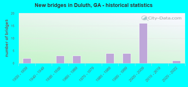
- New bridges - historical statistics
- 21930-1939
- 31950-1959
- 31960-1969
- 41980-1989
- 41990-1999
- 162000-2009
- 12020-2022

- Reconstructed bridges - Historical Statistics
- 11950-1959
- 01960-1969
- 11970-1979
- 01980-1989
- 11990-1999
- 52000-2009


- Bridge Condition - Deck
- 10.7%Very good
- 89.3%Good

- Bridge Condition - Superstructure
- 67.9%Very good
- 28.6%Good
- 3.6%Satisfactory

- Bridge Condition - Substructure
- 17.9%Very good
- 75.0%Good
- 7.1%Satisfactory

- Bridge Condition - Channel
- 5.6%Excellent
- 50.0%Very good
- 27.8%Good
- 16.7%Satisfactory

- Bridge Condition - Culverts
- 60.0%Good
- 40.0%Satisfactory
Find on map >> Show street view
Structure Number: 1350022, Location: 1 MI SE OF DULUTH (Lat: 33.984797, Lng: -84.127650), Route carried "on" structure: State highway 120, Year Built: 1939, Year Reconstructed: 1950, Status: Open, Structure Length: 0.82m (2.69ft), Average Daily Traffic: 14,900 (year 2012), Truck Traffic: 1%, Average Future Daily Traffic: 22,350 (year 2032), Design Load: H 15, Features Intersected: KNOX BRANCH, Facility Carried by Structure: DULUTH HIGHWAY
Minimum Vertical Clearance: 30+ m (98+ ft), Kilometerpoint: 6.437, Lanes on structure: 2, Base Highway Network: Yes, Owner: State Highway Agency, Approaching Roadway Width: 7.6m (24.9ft), Skew: 1 degrees, Material/Design: Concrete, Design/Construction: Culvert, Number Of Spans In Main Unit: 3, Length of Maximum Span: 2.4m (7.9ft)
Condition: Channel: Satisfactory, Culverts: Good, Structural Evaluation: Better than present minimum criteria, Waterway Adequacy: Equal to present desirable criteria, Approach Roadway Alignment: Equal to present minimum criteria, Designated Inspection Frequency: Every 24 months, Inspection Date: December 2021, Bridge Improvement Cost: $105,000, Roadway Improvement Cost: $11,000, Total Project Cost: $158,000
Find on map >> Show street view
Structure Number: 1350023, Location: 1.5 MI E OF DULUTH (Lat: 33.978689, Lng: -84.109497), Route carried "on" structure: State highway 120, Year Built: 1938, Status: Open, Structure Length: 2.29m (7.51ft), Average Daily Traffic: 20,360 (year 2012), Truck Traffic: 1%, Average Future Daily Traffic: 30,540 (year 2032), Design Load: H 15, Features Intersected: SWEETWATER CREEK, Facility Carried by Structure: DULUTH HIGHWAY
Minimum Vertical Clearance: 30+ m (98+ ft), Kilometerpoint: 8.047, Lanes on structure: 2, Base Highway Network: Yes, Owner: State Highway Agency, Approaching Roadway Width: 12.2m (40.0ft), Skew: 2 degrees, Material/Design: Steel continuous, Design/Construction: Stringer/Multi-beam, Number Of Spans In Main Unit: 3, Length of Maximum Span: 7.6m (24.9ft), Curb-To-Curb Width: 7.3m (24.0ft), Out-to-Out Width: 8.1m (26.6ft)
Condition: Deck: Good, Superstructure: Very good, Substructure: Satisfactory, Channel: Very good, Operating Rating: 31.7 metric tons, Method Used To Determine Operating Rating: Allowable Stress (AS), Inventory Rating: 19.9 metric tons, Method Used To Determine Inventory Rating: Allowable Stress (AS), Structural Evaluation: Somewhat better than minimum adequacy, Deck Geometry: High priority of replacement, Waterway Adequacy: Equal to present desirable criteria, Approach Roadway Alignment: Equal to present minimum criteria, Length Of Structure Improvement: 42.58m (139.70ft), Designated Inspection Frequency: Every 24 months, Inspection Date: December 2021, Bridge Improvement Cost: $293,000, Roadway Improvement Cost: $29,000, Total Project Cost: $440,000, Deck Structure Type: Concrete Cast-file-Place, Wearing Surface/Protective System: Wearing Surface: Bituminous
Find on map >> Show street view
Structure Number: 1350038, Location: 7.2 MI W OF LAWRENCEVILLE (Lat: 33.963558, Lng: -84.089917), Route carried "on" structure: State highway 316, Year Built: 1960, Year Reconstructed: 2007, Status: Open, Structure Length: 0.91m (2.99ft), Average Daily Traffic: 87,580 (year 2012), Truck Traffic: 1%, Average Future Daily Traffic: 131,370 (year 2032), Design Load: HS 20+Mod, Features Intersected: FORK CREEK
Minimum Vertical Clearance: 30+ m (98+ ft), Kilometerpoint: 1.609, Lanes on structure: 9, Base Highway Network: Yes, Owner: State Highway Agency, Approaching Roadway Width: 38.4m (126.0ft), Skew: 19 degrees, Material/Design: Concrete, Design/Construction: Culvert, Number Of Spans In Main Unit: 2, Length of Maximum Span: 4.3m (14.1ft)
Condition: Channel: Very good, Culverts: Good, Operating Rating: 55.3 metric tons, Method Used To Determine Operating Rating: Load Factor (LF), Inventory Rating: 32.6 metric tons, Method Used To Determine Inventory Rating: Load Factor (LF), Structural Evaluation: Better than present minimum criteria, Waterway Adequacy: Equal to present desirable criteria, Approach Roadway Alignment: Equal to present desirable criteria, Designated Inspection Frequency: Every 24 months, Underwater Inspection Frequency: Every 60 months, Inspection Date: October 2021, Underwater Inspection Date: November 2021, Bridge Improvement Cost: $341,000, Roadway Improvement Cost: $34,000, Total Project Cost: $511,000
Find on map >> Show street view
Structure Number: 1350052, Location: 3.5 MI SE OF DULUTH (Lat: 33.962811, Lng: -84.104475), Route carried "on" structure: Interstate 85, Year Built: 1958, Year Reconstructed: 2008, Status: Open, Structure Length: 4.63m (15.19ft), Average Daily Traffic: 146,900 (year 2012), Truck Traffic: 12%, Average Future Daily Traffic: 220,350 (year 2032), Design Load: HS 20+Mod, Features Intersected: SWEETWATER CREEK
Minimum Vertical Clearance: 30+ m (98+ ft), Kilometerpoint: 170.590, Lanes on structure: 7, Base Highway Network: Yes, Owner: State Highway Agency, Approaching Roadway Width: 39.9m (130.9ft), Skew: 10 degrees, Material/Design: Prestressed concrete, Design/Construction: Stringer/Multi-beam, Number Of Spans In Main Unit: 3, Length of Maximum Span: 17.1m (56.1ft), Curb-To-Curb Width: 39.6m (129.9ft), Out-to-Out Width: 40.6m (133.2ft)
Condition: Deck: Good, Superstructure: Very good, Substructure: Good, Channel: Good, Operating Rating: 67.1 metric tons, Method Used To Determine Operating Rating: Load Factor (LF), Inventory Rating: 38.1 metric tons, Method Used To Determine Inventory Rating: Load Factor (LF), Structural Evaluation: Better than present minimum criteria, Deck Geometry: Superior to present desirable criteria, Waterway Adequacy: Equal to present desirable criteria, Approach Roadway Alignment: Equal to present desirable criteria, Designated Inspection Frequency: Every 24 months, Inspection Date: January 2022, Bridge Improvement Cost: $1,404,000, Roadway Improvement Cost: $140,000, Total Project Cost: $2,106,000, Deck Structure Type: Concrete Cast-file-Place
Find on map >> Show street view
Structure Number: 1350053, Location: 3.5 MI SE OF DULUTH (Lat: 33.963389, Lng: -84.105189), Route carried "on" structure: Interstate 85, Year Built: 1958, Year Reconstructed: 2008, Status: Open, Structure Length: 4.63m (15.19ft), Average Daily Traffic: 146,900 (year 2012), Truck Traffic: 12%, Average Future Daily Traffic: 220,350 (year 2032), Design Load: HS 20+Mod, Features Intersected: SWEETWATER CREEK
Minimum Vertical Clearance: 30+ m (98+ ft), Kilometerpoint: 170.590, Lanes on structure: 6, Base Highway Network: Yes, Owner: State Highway Agency, Approaching Roadway Width: 34.1m (111.9ft), Skew: 10 degrees, Material/Design: Prestressed concrete, Design/Construction: Stringer/Multi-beam, Number Of Spans In Main Unit: 3, Length of Maximum Span: 17.1m (56.1ft), Curb-To-Curb Width: 34.7m (113.8ft), Out-to-Out Width: 35.7m (117.1ft)
Condition: Deck: Good, Superstructure: Good, Substructure: Good, Channel: Satisfactory, Operating Rating: 64.4 metric tons, Method Used To Determine Operating Rating: Load Factor (LF), Inventory Rating: 35.3 metric tons, Method Used To Determine Inventory Rating: Load Factor (LF), Structural Evaluation: Better than present minimum criteria, Deck Geometry: Superior to present desirable criteria, Waterway Adequacy: Superior to present desirable criteria, Approach Roadway Alignment: Equal to present desirable criteria, Designated Inspection Frequency: Every 24 months, Inspection Date: January 2022, Bridge Improvement Cost: $1,242,000, Roadway Improvement Cost: $124,000, Total Project Cost: $1,863,000, Deck Structure Type: Concrete Cast-file-Place, Wearing Surface/Protective System: Deck Protection: Epoxy Coated Reinforcing
Find on map >> Show street view
Structure Number: 1350073, Location: 3.3 MI S OF DULUTH (Lat: 33.952247, Lng: -84.129975), Route carried "on" structure: County highway 2343, Year Built: 1958, Year Reconstructed: 1984, Status: Open, Structure Length: 6.46m (21.19ft), Average Daily Traffic: 48,770 (year 2012), Truck Traffic: 1%, Average Future Daily Traffic: 73,155 (year 2032), Design Load: HS 20+Mod, Features Intersected: I-85, Facility Carried by Structure: PLEASANT HILL RD
Minimum Vertical Clearance: 30+ m (98+ ft), Kilometerpoint: 1.609, Lanes on structure: 8, Lanes under structure: 12, Base Highway Network: Yes, Owner: State Highway Agency, Approaching Roadway Width: 26.2m (86.0ft), Material/Design: Steel continuous, Design/Construction: Stringer/Multi-beam, Number Of Spans In Main Unit: 4, Length of Maximum Span: 24.7m (81.0ft), Curb or Sidewalk Widths: Left: 3.0m (9.8ft), Right: 1.8m (5.9ft), Curb-To-Curb Width: 30.6m (100.4ft), Out-to-Out Width: 34.8m (114.2ft)
Condition: Deck: Good, Superstructure: Very good, Substructure: Good, Operating Rating: 56.2 metric tons, Method Used To Determine Operating Rating: Load Factor (LF), Inventory Rating: 33.5 metric tons, Method Used To Determine Inventory Rating: Load Factor (LF), Structural Evaluation: Better than present minimum criteria, Deck Geometry: Somewhat better than minimum adequacy, Underclear: High priority of corrective action, Approach Roadway Alignment: Better than present minimum criteria, Designated Inspection Frequency: Every 24 months, Inspection Date: January 2022, Bridge Improvement Cost: $2,184,000, Roadway Improvement Cost: $218,000, Total Project Cost: $3,276,000, Deck Structure Type: Concrete Cast-file-Place
Find on map >> Show street view
Structure Number: 1350102, Location: 1 MI N OF DULUTH (Lat: 34.032858, Lng: -84.107150), Route carried "on" structure: County highway 2947, Year Built: 1982, Status: Open, Structure Length: 8.53m (27.99ft), Average Daily Traffic: 33,620 (year 2012), Truck Traffic: 1%, Average Future Daily Traffic: 50,430 (year 2032), Design Load: HS 20+Mod, Features Intersected: SUWANEE CREEK, Facility Carried by Structure: P'TREE IND N/B
Minimum Vertical Clearance: 30+ m (98+ ft), Kilometerpoint: 17.703, Lanes on structure: 2, Base Highway Network: Yes, Owner: County Highway Agency, Approaching Roadway Width: 11.3m (37.1ft), Skew: 10 degrees, Material/Design: Prestressed concrete, Design/Construction: Stringer/Multi-beam, Number Of Spans In Main Unit: 4, Length of Maximum Span: 21.3m (69.9ft), Curb-To-Curb Width: 14.6m (47.9ft), Out-to-Out Width: 15.5m (50.9ft)
Condition: Deck: Good, Superstructure: Very good, Substructure: Good, Channel: Satisfactory, Operating Rating: 72.5 metric tons, Method Used To Determine Operating Rating: Load Factor (LF), Inventory Rating: 29.0 metric tons, Method Used To Determine Inventory Rating: Load Factor (LF), Structural Evaluation: Better than present minimum criteria, Deck Geometry: Superior to present desirable criteria, Waterway Adequacy: Equal to present desirable criteria, Approach Roadway Alignment: Better than present minimum criteria, Designated Inspection Frequency: Every 24 months, Underwater Inspection Frequency: Every 60 months, Inspection Date: December 2021, Underwater Inspection Date: January 2022, Bridge Improvement Cost: $1,094,000, Roadway Improvement Cost: $109,000, Total Project Cost: $1,641,000, Deck Structure Type: Concrete Cast-file-Place
Find on map >> Show street view
Structure Number: 1350107, Location: 3.8 MI S OF DULUTH (Lat: 33.948486, Lng: -84.137719), Route carried "on" structure: County highway 557, Year Built: 1986, Year Reconstructed: 2003, Status: Open, Structure Length: 6.28m (20.60ft), Average Daily Traffic: 38,420 (year 2012), Truck Traffic: 1%, Average Future Daily Traffic: 57,630 (year 2032), Design Load: HS 20+Mod, Features Intersected: I-85, Facility Carried by Structure: STEVE REYNOLDS BLV
Minimum Vertical Clearance: 30+ m (98+ ft), Kilometerpoint: 1.609, Lanes on structure: 7, Lanes under structure: 12, Owner: State Highway Agency, Approaching Roadway Width: 29.9m (98.1ft), Material/Design: Prestressed concrete, Design/Construction: Stringer/Multi-beam, Number Of Spans In Main Unit: 2, Length of Maximum Span: 31.4m (103.0ft), Curb or Sidewalk Widths: Left: 1.8m (5.9ft), Right: 1.8m (5.9ft), Curb-To-Curb Width: 29.0m (95.1ft), Out-to-Out Width: 33.5m (109.9ft)
Condition: Deck: Good, Superstructure: Good, Substructure: Good, Operating Rating: 46.2 metric tons, Method Used To Determine Operating Rating: Allowable Stress (AS), Inventory Rating: 32.6 metric tons, Method Used To Determine Inventory Rating: Allowable Stress (AS), Structural Evaluation: Better than present minimum criteria, Deck Geometry: Somewhat better than minimum adequacy, Underclear: Equal to present minimum criteria, Approach Roadway Alignment: Equal to present desirable criteria, Designated Inspection Frequency: Every 24 months, Inspection Date: January 2022, Bridge Improvement Cost: $1,902,000, Roadway Improvement Cost: $190,000, Total Project Cost: $2,854,000, Deck Structure Type: Concrete Cast-file-Place
Find on map >> Show street view
Structure Number: 1355108, Location: 2.3 MI SE OF DULUTH (Lat: 33.964989, Lng: -84.107858), Route carried "on" structure: County highway 2001, Year Built: 1983, Status: Open, Structure Length: 1.22m (4.00ft), Average Daily Traffic: 34,100 (year 2012), Truck Traffic: 1%, Average Future Daily Traffic: 51,150 (year 2032), Design Load: HS 20+Mod, Features Intersected: SWEETWATER CREEK, Facility Carried by Structure: SATELLITE BLVD.
Minimum Vertical Clearance: 30+ m (98+ ft), Kilometerpoint: 4.828, Lanes on structure: 5, Base Highway Network: Yes, Owner: County Highway Agency, Approaching Roadway Width: 19.2m (63.0ft), Skew: 1 degrees, Material/Design: Concrete, Design/Construction: Culvert, Number Of Spans In Main Unit: 4, Length of Maximum Span: 2.7m (8.9ft)
Condition: Channel: Very good, Culverts: Satisfactory, Operating Rating: 55.3 metric tons, Method Used To Determine Operating Rating: Field evaluation and documented engineering judgment, Inventory Rating: 32.6 metric tons, Method Used To Determine Inventory Rating: Field evaluation and documented engineering judgment, Structural Evaluation: Equal to present minimum criteria, Waterway Adequacy: Equal to present desirable criteria, Approach Roadway Alignment: Equal to present desirable criteria, Designated Inspection Frequency: Every 24 months, Inspection Date: December 2021, Bridge Improvement Cost: $284,000, Roadway Improvement Cost: $28,000, Total Project Cost: $426,000
Find on map >> Show street view
Structure Number: 1355109, Location: 2.4 MI SE OF DULUTH (Lat: 33.966342, Lng: -84.104508), Route carried "on" structure: County highway 2001, Year Built: 1983, Status: Open, Structure Length: 0.98m (3.22ft), Average Daily Traffic: 34,100 (year 2012), Truck Traffic: 1%, Average Future Daily Traffic: 51,150 (year 2032), Design Load: HS 20+Mod, Features Intersected: SINGLETON CREEK, Facility Carried by Structure: SATELLITE BLVD
Minimum Vertical Clearance: 30+ m (98+ ft), Kilometerpoint: 4.828, Lanes on structure: 5, Base Highway Network: Yes, Owner: County Highway Agency, Approaching Roadway Width: 19.8m (65.0ft), Material/Design: Concrete, Design/Construction: Culvert, Number Of Spans In Main Unit: 3, Length of Maximum Span: 3.0m (9.8ft)
Condition: Channel: Very good, Culverts: Good, Operating Rating: 55.3 metric tons, Method Used To Determine Operating Rating: Field evaluation and documented engineering judgment, Inventory Rating: 32.6 metric tons, Method Used To Determine Inventory Rating: Field evaluation and documented engineering judgment, Structural Evaluation: Better than present minimum criteria, Waterway Adequacy: Better than present minimum criteria, Approach Roadway Alignment: Equal to present desirable criteria, Designated Inspection Frequency: Every 24 months, Inspection Date: December 2021, Bridge Improvement Cost: $227,000, Roadway Improvement Cost: $23,000, Total Project Cost: $341,000
Find on map >> Show street view
Structure Number: 1355125, Location: 2 MI SE OF DULUTH (Lat: 33.974247, Lng: -84.129400), Route carried "on" structure: County highway 588, Year Built: 1960, Status: Open, Structure Length: 1.10m (3.61ft), Average Daily Traffic: 1,930 (year 2012), Truck Traffic: 1%, Average Future Daily Traffic: 2,895 (year 2032), Design Load: H 15, Features Intersected: SWEETWATER CREEK (LAKE), Facility Carried by Structure: CARDINAL LAKE DR.
Minimum Vertical Clearance: 30+ m (98+ ft), Kilometerpoint: 0.000, Lanes on structure: 2, Base Highway Network: Yes, Owner: County Highway Agency, Approaching Roadway Width: 6.4m (21.0ft), Material/Design: Concrete, Design/Construction: Tee Beam, Number Of Spans In Main Unit: 3, Length of Maximum Span: 3.7m (12.1ft), Curb-To-Curb Width: 6.2m (20.3ft), Out-to-Out Width: 6.2m (20.3ft)
Condition: Deck: Good, Superstructure: Good, Substructure: Good, Channel: Very good, Operating Rating: 35.3 metric tons, Method Used To Determine Operating Rating: Field evaluation and documented engineering judgment, Inventory Rating: 24.4 metric tons, Method Used To Determine Inventory Rating: Field evaluation and documented engineering judgment, Structural Evaluation: Equal to present minimum criteria, Deck Geometry: High priority of replacement, Waterway Adequacy: Superior to present desirable criteria, Approach Roadway Alignment: Equal to present minimum criteria, Designated Inspection Frequency: Every 24 months, Inspection Date: December 2021, Bridge Improvement Cost: $141,000, Roadway Improvement Cost: $14,000, Total Project Cost: $211,000, Deck Structure Type: Concrete Cast-file-Place, Wearing Surface/Protective System: Wearing Surface: Bituminous
Find on map >> Show street view
Structure Number: 1355129, Location: 1.5 MI SE OF DULUTH (Lat: 33.985239, Lng: -84.137600), Route carried "on" structure: County highway 1876, Year Built: 1960, Status: Open, Structure Length: 0.70m (2.30ft), Average Daily Traffic: 1,930 (year 2012), Truck Traffic: 1%, Average Future Daily Traffic: 2,895 (year 2032), Design Load: H 15, Features Intersected: SWEETWATER CREEK (LAKE), Facility Carried by Structure: BRISTOL DRIVE
Minimum Vertical Clearance: 30+ m (98+ ft), Kilometerpoint: 0.000, Lanes on structure: 2, Base Highway Network: Yes, Owner: County Highway Agency, Approaching Roadway Width: 7.6m (24.9ft), Material/Design: Concrete, Design/Construction: Tee Beam, Number Of Spans In Main Unit: 2, Length of Maximum Span: 3.7m (12.1ft), Curb or Sidewalk Widths: Left: 0.1m (0.3ft), Right: 0.1m (0.3ft), Curb-To-Curb Width: 7.7m (25.3ft), Out-to-Out Width: 8.1m (26.6ft)
Condition: Deck: Good, Superstructure: Satisfactory, Substructure: Good, Channel: Very good, Operating Rating: 34.4 metric tons, Method Used To Determine Operating Rating: Field evaluation and documented engineering judgment, Inventory Rating: 24.4 metric tons, Method Used To Determine Inventory Rating: Field evaluation and documented engineering judgment, Structural Evaluation: Equal to present minimum criteria, Deck Geometry: Meets minimum limits, Waterway Adequacy: Equal to present desirable criteria, Approach Roadway Alignment: Equal to present minimum criteria, Designated Inspection Frequency: Every 24 months, Inspection Date: December 2021, Bridge Improvement Cost: $90,000, Roadway Improvement Cost: $9,000, Total Project Cost: $135,000, Deck Structure Type: Concrete Cast-file-Place, Wearing Surface/Protective System: Wearing Surface: Bituminous
Find on map >> Show street view
Structure Number: 1355173, Location: 3 MI N OF DULUTH (Lat: 33.987628, Lng: -84.084100), Route carried "on" structure: Interstate 85, Year Built: 1999, Status: Open, Structure Length: 4.94m (16.21ft), Average Daily Traffic: 146,660 (year 2012), Truck Traffic: 1%, Average Future Daily Traffic: 219,990 (year 2032), Design Load: HS 20+Mod, Features Intersected: SUGARLOAF PARKWAY
Minimum Vertical Clearance: 30+ m (98+ ft), Kilometerpoint: 173.809, Lanes on structure: 16, Lanes under structure: 9, Base Highway Network: Yes, Owner: State Highway Agency, Approaching Roadway Width: 61.0m (200.1ft), Skew: 30 degrees, Material/Design: Steel, Design/Construction: Stringer/Multi-beam, Number Of Spans In Main Unit: 1, Length of Maximum Span: 49.4m (162.1ft), Curb-To-Curb Width: 108.1m (354.7ft), Out-to-Out Width: 113.2m (371.4ft)
Condition: Deck: Good, Superstructure: Very good, Substructure: Good, Operating Rating: 46.2 metric tons, Method Used To Determine Operating Rating: Allowable Stress (AS), Inventory Rating: 32.6 metric tons, Method Used To Determine Inventory Rating: Allowable Stress (AS), Structural Evaluation: Better than present minimum criteria, Deck Geometry: Superior to present desirable criteria, Underclear: Equal to present minimum criteria, Approach Roadway Alignment: Equal to present desirable criteria, Designated Inspection Frequency: Every 24 months, Inspection Date: January 2022, Bridge Improvement Cost: $3,050,000, Roadway Improvement Cost: $305,000, Total Project Cost: $4,575,000, Deck Structure Type: Concrete Cast-file-Place
Find on map >> Show street view
Structure Number: 1355177, Location: 3.3 MI SE OF DULUTH (Lat: 33.964197, Lng: -84.094839), Route carried "on" structure: City street 9462, Year Built: 1999, Year Reconstructed: 2008, Status: Open, Structure Length: 8.90m (29.20ft), Average Daily Traffic: 18,190 (year 2012), Truck Traffic: 1%, Average Future Daily Traffic: 27,285 (year 2032), Design Load: HS 20+Mod, Features Intersected: SR 316, RAMPS 316 EB, WB, Facility Carried by Structure: BOGGS ROAD
Minimum Vertical Clearance: 30+ m (98+ ft), Kilometerpoint: 1.609, Lanes on structure: 5, Lanes under structure: 9, Base Highway Network: Yes, Owner: State Highway Agency, Approaching Roadway Width: 17.1m (56.1ft), Skew: 23 degrees, Material/Design: Prestressed concrete, Design/Construction: Stringer/Multi-beam, Number Of Spans In Main Unit: 4, Length of Maximum Span: 29.3m (96.1ft), Curb or Sidewalk Widths: Left: 1.8m (5.9ft), Right: 1.8m (5.9ft), Curb-To-Curb Width: 21.9m (71.9ft), Out-to-Out Width: 26.4m (86.6ft)
Condition: Deck: Good, Superstructure: Very good, Substructure: Good, Operating Rating: 38.1 metric tons, Method Used To Determine Operating Rating: Load Factor (LF), Inventory Rating: 22.6 metric tons, Method Used To Determine Inventory Rating: Load Factor (LF), Structural Evaluation: Somewhat better than minimum adequacy, Deck Geometry: Somewhat better than minimum adequacy, Underclear: Equal to present minimum criteria, Approach Roadway Alignment: Equal to present desirable criteria, Designated Inspection Frequency: Every 24 months, Inspection Date: September 2021, Bridge Improvement Cost: $2,074,000, Roadway Improvement Cost: $207,000, Total Project Cost: $3,112,000, Deck Structure Type: Concrete Cast-file-Place
Find on map >> Show street view
Structure Number: 1355181, Location: 3.2 MI SE OF DULUTH (Lat: 33.967331, Lng: -84.096431), Route carried "on" structure: City street 9462, Year Built: 1999, Status: Open, Structure Length: 12.71m (41.70ft), Average Daily Traffic: 11,060 (year 2012), Truck Traffic: 1%, Average Future Daily Traffic: 16,590 (year 2032), Design Load: HS 20+Mod, Features Intersected: I-85, Facility Carried by Structure: BOGGS ROAD
Minimum Vertical Clearance: 30+ m (98+ ft), Kilometerpoint: 1.609, Lanes on structure: 5, Lanes under structure: 16, Base Highway Network: Yes, Owner: State Highway Agency, Approaching Roadway Width: 20.7m (67.9ft), Skew: 20 degrees, Material/Design: Prestressed concrete, Design/Construction: Stringer/Multi-beam, Number Of Spans In Main Unit: 4, Length of Maximum Span: 35.4m (116.1ft), Curb or Sidewalk Widths: Left: 1.8m (5.9ft), Right: 1.8m (5.9ft), Curb-To-Curb Width: 28.0m (91.9ft), Out-to-Out Width: 32.7m (107.3ft)
Condition: Deck: Good, Superstructure: Very good, Substructure: Good, Operating Rating: 44.4 metric tons, Method Used To Determine Operating Rating: Load Factor (LF), Inventory Rating: 26.3 metric tons, Method Used To Determine Inventory Rating: Load Factor (LF), Structural Evaluation: Equal to present minimum criteria, Deck Geometry: Superior to present desirable criteria, Underclear: Somewhat better than minimum adequacy, Approach Roadway Alignment: Equal to present desirable criteria, Designated Inspection Frequency: Every 24 months, Inspection Date: October 2021, Bridge Improvement Cost: $2,962,000, Roadway Improvement Cost: $296,000, Total Project Cost: $4,444,000, Deck Structure Type: Concrete Cast-file-Place
Find on map >> Show street view
Structure Number: 1355191, Location: 1 MI N OF DULUTH (Lat: 34.032589, Lng: -84.107078), Route carried "on" structure: County highway 2947, Year Built: 2000, Status: Open, Structure Length: 14.57m (47.80ft), Average Daily Traffic: 33,620 (year 2012), Truck Traffic: 1%, Average Future Daily Traffic: 50,430 (year 2032), Design Load: HS 20+Mod, Features Intersected: SUWANEE CREEK, Facility Carried by Structure: P'TREE IND S/B
Minimum Vertical Clearance: 30+ m (98+ ft), Kilometerpoint: 17.703, Lanes on structure: 2, Base Highway Network: Yes, Owner: County Highway Agency, Approaching Roadway Width: 11.3m (37.1ft), Skew: 11 degrees, Material/Design: Prestressed concrete, Design/Construction: Stringer/Multi-beam, Number Of Spans In Main Unit: 4, Length of Maximum Span: 36.6m (120.1ft), Curb-To-Curb Width: 11.4m (37.4ft), Out-to-Out Width: 12.5m (41.0ft)
Condition: Deck: Good, Superstructure: Very good, Substructure: Good, Channel: Very good, Operating Rating: 84.3 metric tons, Method Used To Determine Operating Rating: Allowable Stress (AS), Inventory Rating: 40.8 metric tons, Method Used To Determine Inventory Rating: Allowable Stress (AS), Structural Evaluation: Better than present minimum criteria, Deck Geometry: Equal to present minimum criteria, Waterway Adequacy: Superior to present desirable criteria, Approach Roadway Alignment: Better than present minimum criteria, Designated Inspection Frequency: Every 24 months, Inspection Date: December 2021, Bridge Improvement Cost: $1,868,000, Roadway Improvement Cost: $187,000, Total Project Cost: $2,801,000, Deck Structure Type: Concrete Cast-file-Place
Find on map >> Show street view
Structure Number: 1355193, Location: 2.5 MI E OF DULUTH (Lat: 33.976797, Lng: -84.089550), Route carried "on" structure: State highway 120, Year Built: 2001, Status: Open, Structure Length: 12.80m (41.99ft), Average Daily Traffic: 20,870 (year 2012), Truck Traffic: 1%, Average Future Daily Traffic: 31,305 (year 2032), Design Load: HS 20+Mod, Features Intersected: I-85, 2 RAMPS, Facility Carried by Structure: DULUTH HIGHWAY
Minimum Vertical Clearance: 30+ m (98+ ft), Kilometerpoint: 9.656, Lanes on structure: 9, Lanes under structure: 14, Base Highway Network: Yes, Owner: State Highway Agency, Approaching Roadway Width: 35.4m (116.1ft), Skew: 21 degrees, Material/Design: Prestressed concrete, Design/Construction: Stringer/Multi-beam, Number Of Spans In Main Unit: 4, Length of Maximum Span: 39.6m (129.9ft), Curb or Sidewalk Widths: Left: 1.8m (5.9ft), Right: 1.8m (5.9ft), Curb-To-Curb Width: 40.2m (131.9ft), Out-to-Out Width: 46.1m (151.2ft)
Condition: Deck: Good, Superstructure: Good, Substructure: Good, Operating Rating: 49.8 metric tons, Method Used To Determine Operating Rating: Load Factor (LF), Inventory Rating: 29.9 metric tons, Method Used To Determine Inventory Rating: Load Factor (LF), Structural Evaluation: Better than present minimum criteria, Deck Geometry: Superior to present desirable criteria, Underclear: Meets minimum limits, Approach Roadway Alignment: Equal to present minimum criteria, Designated Inspection Frequency: Every 24 months, Inspection Date: October 2021, Bridge Improvement Cost: $4,774,000, Roadway Improvement Cost: $477,000, Total Project Cost: $7,161,000, Deck Structure Type: Concrete Cast-file-Place
Find on map >> Show street view
Structure Number: 1355194, Location: 2 MI E OF DULUTH (Lat: 33.980928, Lng: -84.086686), Route carried "on" structure: Ramp Interstate 85, Year Built: 2001, Status: Open, Structure Length: 6.34m (20.80ft), Average Daily Traffic: 4,810 (year 2012), Truck Traffic: 1%, Average Future Daily Traffic: 7,215 (year 2032), Design Load: HS 20, Features Intersected: 403 CONNECTOR.
Minimum Vertical Clearance: 30+ m (98+ ft), Kilometerpoint: 173.809, Lanes on structure: 2, Lanes under structure: 4, Base Highway Network: Yes, Owner: State Highway Agency, Approaching Roadway Width: 12.2m (40.0ft), Material/Design: Prestressed concrete, Design/Construction: Stringer/Multi-beam, Number Of Spans In Main Unit: 1, Length of Maximum Span: 26.8m (87.9ft), Curb-To-Curb Width: 13.4m (44.0ft), Out-to-Out Width: 14.3m (46.9ft)
Condition: Deck: Good, Superstructure: Very good, Substructure: Good, Operating Rating: 46.2 metric tons, Method Used To Determine Operating Rating: Allowable Stress (AS), Inventory Rating: 18.1 metric tons, Method Used To Determine Inventory Rating: Allowable Stress (AS), Structural Evaluation: Somewhat better than minimum adequacy, Deck Geometry: Superior to present desirable criteria, Underclear: Equal to present minimum criteria, Approach Roadway Alignment: Equal to present minimum criteria, Designated Inspection Frequency: Every 24 months, Inspection Date: October 2021, Bridge Improvement Cost: $813,000, Roadway Improvement Cost: $81,000, Total Project Cost: $1,219,000, Deck Structure Type: Concrete Cast-file-Place
Find on map >> Show street view
Structure Number: 1355195, Location: 2.5 MI E OF DULUTH (Lat: 33.982006, Lng: -84.087778), Route carried "on" structure: Ramp Interstate 85, Year Built: 2001, Status: Open, Structure Length: 7.62m (25.00ft), Average Daily Traffic: 7,830 (year 2012), Truck Traffic: 1%, Average Future Daily Traffic: 11,745 (year 2032), Design Load: HS 20, Features Intersected: 403 CONNECTOR.
Minimum Vertical Clearance: 30+ m (98+ ft), Kilometerpoint: 172.200, Lanes on structure: 2, Lanes under structure: 4, Owner: State Highway Agency, Approaching Roadway Width: 11.6m (38.1ft), Material/Design: Prestressed concrete, Design/Construction: Stringer/Multi-beam, Number Of Spans In Main Unit: 1, Length of Maximum Span: 26.8m (87.9ft), Curb-To-Curb Width: 13.3m (43.6ft), Out-to-Out Width: 14.3m (46.9ft)
Condition: Deck: Good, Superstructure: Very good, Substructure: Good, Operating Rating: 45.3 metric tons, Method Used To Determine Operating Rating: Allowable Stress (AS), Inventory Rating: 32.6 metric tons, Method Used To Determine Inventory Rating: Allowable Stress (AS), Structural Evaluation: Better than present minimum criteria, Deck Geometry: Superior to present desirable criteria, Underclear: Equal to present desirable criteria, Approach Roadway Alignment: Equal to present minimum criteria, Designated Inspection Frequency: Every 24 months, Inspection Date: January 2022, Bridge Improvement Cost: $977,000, Roadway Improvement Cost: $98,000, Total Project Cost: $1,465,000, Deck Structure Type: Concrete Cast-file-Place
Find on map >> Show street view
Structure Number: 1355196, Location: 5.5 MI W OF LARWENCEVILLE (Lat: 33.963475, Lng: -84.088944), Route carried "on" structure: County highway 2731, Year Built: 2001, Status: Open, Structure Length: 15.09m (49.51ft), Average Daily Traffic: 16,630 (year 2012), Truck Traffic: 1%, Average Future Daily Traffic: 24,945 (year 2032), Design Load: HS 20+Mod, Features Intersected: SR 316, Facility Carried by Structure: BRECKINRIDGE BLVD
Minimum Vertical Clearance: 30+ m (98+ ft), Kilometerpoint: 4.828, Lanes on structure: 4, Lanes under structure: 5, Base Highway Network: Yes, Owner: State Highway Agency, Approaching Roadway Width: 19.2m (63.0ft), Skew: 24 degrees, Material/Design: Prestressed concrete, Design/Construction: Stringer/Multi-beam, Number Of Spans In Main Unit: 4, Length of Maximum Span: 43.0m (141.1ft), Curb or Sidewalk Widths: Left: 1.8m (5.9ft), Right: 1.8m (5.9ft), Curb-To-Curb Width: 24.0m (78.7ft), Out-to-Out Width: 31.2m (102.4ft)
Condition: Deck: Good, Superstructure: Very good, Substructure: Good, Operating Rating: 76.2 metric tons, Method Used To Determine Operating Rating: Allowable Stress (AS), Inventory Rating: 38.1 metric tons, Method Used To Determine Inventory Rating: Allowable Stress (AS), Structural Evaluation: Better than present minimum criteria, Deck Geometry: Superior to present desirable criteria, Underclear: High priority of corrective action, Approach Roadway Alignment: Better than present minimum criteria, Designated Inspection Frequency: Every 24 months, Inspection Date: October 2021, Bridge Improvement Cost: $2,989,000, Roadway Improvement Cost: $299,000, Total Project Cost: $4,484,000, Deck Structure Type: Concrete Cast-file-Place
Find on map >> Show street view
Structure Number: 1355203, Location: 3.3 MI SE OF DULUTH (Lat: 33.959561, Lng: -84.114383), Route carried "on" structure: County highway 1046, Year Built: 2007, Status: Open, Structure Length: 13.84m (45.41ft), Average Daily Traffic: 24,760 (year 2012), Truck Traffic: 1%, Average Future Daily Traffic: 37,140 (year 2032), Design Load: HS 20+Mod, Features Intersected: I-85 NB + SB, NBCD, SBCD, Facility Carried by Structure: OLD NORCROSS ROAD
Minimum Vertical Clearance: 30+ m (98+ ft), Kilometerpoint: 3.219, Lanes on structure: 4, Lanes under structure: 20, Owner: State Highway Agency, Approaching Roadway Width: 17.1m (56.1ft), Skew: 22 degrees, Material/Design: Prestressed concrete, Design/Construction: Stringer/Multi-beam, Number Of Spans In Main Unit: 4, Length of Maximum Span: 44.8m (147.0ft), Curb or Sidewalk Widths: Left: 1.8m (5.9ft), Right: 1.8m (5.9ft), Curb-To-Curb Width: 21.9m (71.9ft), Out-to-Out Width: 26.3m (86.3ft)
Condition: Deck: Good, Superstructure: Good, Substructure: Good, Operating Rating: 58.9 metric tons, Method Used To Determine Operating Rating: Load Factor (LF), Inventory Rating: 35.3 metric tons, Method Used To Determine Inventory Rating: Load Factor (LF), Structural Evaluation: Better than present minimum criteria, Deck Geometry: Superior to present desirable criteria, Underclear: High priority of corrective action, Approach Roadway Alignment: Equal to present desirable criteria, Designated Inspection Frequency: Every 24 months, Inspection Date: January 2022, Bridge Improvement Cost: $2,741,000, Roadway Improvement Cost: $274,000, Total Project Cost: $4,112,000, Deck Structure Type: Concrete Cast-file-Place, Wearing Surface/Protective System: Deck Protection: Epoxy Coated Reinforcing
Find on map >> Show street view
Structure Number: 135521, Location: 2.1 MI SE OF DULUTH (Lat: 33.977581, Lng: -84.164694), Route carried "on" structure: County highway 613, Year Built: 2007, Status: Open, Structure Length: 6.31m (20.70ft), Average Daily Traffic: 1,930 (year 2012), Truck Traffic: 1%, Average Future Daily Traffic: 2,895 (year 2032), Design Load: HS 20+Mod, Features Intersected: NS RAILROAD, Facility Carried by Structure: BERKLEY LAKE ROAD
Minimum Vertical Clearance: 30+ m (98+ ft), Kilometerpoint: 0.000, Lanes on structure: 4, Owner: County Highway Agency, Approaching Roadway Width: 16.5m (54.1ft), Skew: 1 degrees, Material/Design: Prestressed concrete, Design/Construction: Stringer/Multi-beam, Number Of Spans In Main Unit: 3, Length of Maximum Span: 26.8m (87.9ft), Curb or Sidewalk Widths: Left: 3.4m (11.2ft), Right: 1.8m (5.9ft), Curb-To-Curb Width: 23.2m (76.1ft), Out-to-Out Width: 30.0m (98.4ft)
Condition: Deck: Very good, Superstructure: Very good, Substructure: Good, Operating Rating: 52.6 metric tons, Method Used To Determine Operating Rating: Allowable Stress (AS), Inventory Rating: 31.7 metric tons, Method Used To Determine Inventory Rating: Allowable Stress (AS), Structural Evaluation: Better than present minimum criteria, Deck Geometry: Superior to present desirable criteria, Underclear: Superior to present desirable criteria, Approach Roadway Alignment: Equal to present minimum criteria, Designated Inspection Frequency: Every 24 months, Inspection Date: Febuary 2022, Bridge Improvement Cost: $1,250,000, Roadway Improvement Cost: $125,000, Total Project Cost: $1,875,000, Deck Structure Type: Concrete Cast-file-Place
Find on map >> Show street view
Structure Number: 1355211, Location: 1.5 MI S.OF DULUTH (Lat: 33.981708, Lng: -84.156758), Route carried "on" structure: State highway 13, Year Built: 2007, Status: Open, Structure Length: 6.22m (20.41ft), Average Daily Traffic: 23,730 (year 2012), Truck Traffic: 1%, Average Future Daily Traffic: 35,595 (year 2032), Design Load: HS 20+Mod, Features Intersected: PLEASANT HILL ROAD
Minimum Vertical Clearance: 30+ m (98+ ft), Kilometerpoint: 11.265, Lanes on structure: 6, Lanes under structure: 7, Base Highway Network: Yes, Owner: State Highway Agency, Approaching Roadway Width: 27.7m (90.9ft), Material/Design: Prestressed concrete, Design/Construction: Stringer/Multi-beam, Number Of Spans In Main Unit: 2, Length of Maximum Span: 31.4m (103.0ft), Curb or Sidewalk Widths: Left: 1.8m (5.9ft), Right: 1.8m (5.9ft), Curb-To-Curb Width: 25.6m (84.0ft), Out-to-Out Width: 30.0m (98.4ft)
Condition: Deck: Good, Superstructure: Very good, Substructure: Good, Operating Rating: 47.1 metric tons, Method Used To Determine Operating Rating: Load Factor (LF), Inventory Rating: 28.1 metric tons, Method Used To Determine Inventory Rating: Load Factor (LF), Structural Evaluation: Better than present minimum criteria, Deck Geometry: Somewhat better than minimum adequacy, Underclear: Superior to present desirable criteria, Approach Roadway Alignment: Better than present minimum criteria, Designated Inspection Frequency: Every 24 months, Inspection Date: Febuary 2022, Bridge Improvement Cost: $1,667,000, Roadway Improvement Cost: $167,000, Total Project Cost: $2,500,000, Deck Structure Type: Concrete Cast-file-Place
Find on map >> Show street view
Structure Number: 1355213, Location: 2 MILES SE OF DULUTH (Lat: 33.965031, Lng: -84.100344), Route carried "on" structure: Ramp State highway 316, Year Built: 2007, Status: Open, Structure Length: 35.39m (116.11ft), Average Daily Traffic: 87,580 (year 2012), Truck Traffic: 1%, Average Future Daily Traffic: 131,370 (year 2032), Design Load: HS 20+Mod, Features Intersected: I-85, NBCD
Minimum Vertical Clearance: 30+ m (98+ ft), Kilometerpoint: 0.000, Lanes on structure: 2, Lanes under structure: 13, Owner: State Highway Agency, Approaching Roadway Width: 18.3m (60.0ft), Skew: 9 degrees, Material/Design: Prestressed concrete, Design/Construction: Stringer/Multi-beam, Number Of Spans In Main Unit: 10, Length of Maximum Span: 40.5m (132.9ft), Curb-To-Curb Width: 18.3m (60.0ft), Out-to-Out Width: 19.3m (63.3ft)
Condition: Deck: Good, Superstructure: Good, Substructure: Satisfactory, Operating Rating: 56.2 metric tons, Method Used To Determine Operating Rating: Load Factor (LF), Inventory Rating: 25.4 metric tons, Method Used To Determine Inventory Rating: Load Factor (LF), Structural Evaluation: Equal to present minimum criteria, Deck Geometry: Superior to present desirable criteria, Underclear: Equal to present minimum criteria, Approach Roadway Alignment: Somewhat better than minimum adequacy, Designated Inspection Frequency: Every 24 months, Inspection Date: January 2022, Bridge Improvement Cost: $4,536,000, Roadway Improvement Cost: $454,000, Total Project Cost: $6,804,000, Deck Structure Type: Concrete Cast-file-Place, Wearing Surface/Protective System: Deck Protection: Epoxy Coated Reinforcing
Find on map >> Show street view
Structure Number: 1355214, Location: 2 MILES SE OF DULUTH (Lat: 33.965536, Lng: -84.102792), Route carried "on" structure: Ramp State highway 316, Year Built: 2007, Status: Open, Structure Length: 79.31m (260.20ft), Average Daily Traffic: 8,200 (year 2012), Truck Traffic: 1%, Average Future Daily Traffic: 12,300 (year 2032), Design Load: HS 20+Mod, Features Intersected: I-85, I-85 NBCD & SBCD
Minimum Vertical Clearance: 30+ m (98+ ft), Kilometerpoint: 0.000, Lanes on structure: 1, Lanes under structure: 16, Owner: State Highway Agency, Approaching Roadway Width: 8.2m (26.9ft), Skew: 9 degrees, Material/Design: Prestressed concrete, Design/Construction: Stringer/Multi-beam, Number Of Spans In Main Unit: 21, Length of Maximum Span: 50.0m (164.0ft), Curb-To-Curb Width: 8.5m (27.9ft), Out-to-Out Width: 9.5m (31.2ft)
Condition: Deck: Good, Superstructure: Good, Substructure: Good, Channel: Very good, Operating Rating: 58.9 metric tons, Method Used To Determine Operating Rating: Allowable Stress (AS), Inventory Rating: 31.7 metric tons, Method Used To Determine Inventory Rating: Allowable Stress (AS), Structural Evaluation: Better than present minimum criteria, Deck Geometry: Superior to present desirable criteria, Underclear: High priority of corrective action, Waterway Adequacy: Equal to present desirable criteria, Approach Roadway Alignment: Equal to present desirable criteria, Designated Inspection Frequency: Every 24 months, Inspection Date: January 2022, Bridge Improvement Cost: $7,394,000, Roadway Improvement Cost: $739,000, Total Project Cost: $11,091,000, Deck Structure Type: Concrete Cast-file-Place, Wearing Surface/Protective System: Deck Protection: Epoxy Coated Reinforcing
Find on map >> Show street view
Structure Number: 1355215, Location: 2 MILES SE OF DULUTH (Lat: 33.963847, Lng: -84.105547), Route carried "on" structure: Ramp Interstate 85, Year Built: 2007, Status: Open, Structure Length: 5.82m (19.09ft), Average Daily Traffic: 8,200 (year 2012), Truck Traffic: 1%, Average Future Daily Traffic: 12,300 (year 2032), Design Load: HS 20+Mod, Features Intersected: SWEETWATER CREEK
Minimum Vertical Clearance: 30+ m (98+ ft), Kilometerpoint: 8.047, Lanes on structure: 2, Owner: State Highway Agency, Approaching Roadway Width: 18.3m (60.0ft), Material/Design: Prestressed concrete, Design/Construction: Stringer/Multi-beam, Number Of Spans In Main Unit: 3, Length of Maximum Span: 30.2m (99.1ft), Curb-To-Curb Width: 18.3m (60.0ft), Out-to-Out Width: 19.3m (63.3ft)
Condition: Deck: Good, Superstructure: Very good, Substructure: Very good, Channel: Good, Operating Rating: 67.1 metric tons, Method Used To Determine Operating Rating: Load Factor (LF), Inventory Rating: 29.9 metric tons, Method Used To Determine Inventory Rating: Load Factor (LF), Structural Evaluation: Better than present minimum criteria, Deck Geometry: Superior to present desirable criteria, Waterway Adequacy: Equal to present desirable criteria, Approach Roadway Alignment: Equal to present desirable criteria, Designated Inspection Frequency: Every 24 months, Inspection Date: January 2022, Bridge Improvement Cost: $746,000, Roadway Improvement Cost: $75,000, Total Project Cost: $1,119,000, Deck Structure Type: Concrete Cast-file-Place, Wearing Surface/Protective System: Deck Protection: Epoxy Coated Reinforcing
Find on map >> Show street view
Structure Number: 1355216, Location: 2 MILES SE OF DULUTH (Lat: 33.963678, Lng: -84.105350), Route carried "on" structure: State highway 316, Year Built: 2007, Status: Open, Structure Length: 7.47m (24.51ft), Average Daily Traffic: 87,580 (year 2012), Truck Traffic: 1%, Average Future Daily Traffic: 131,370 (year 2032), Design Load: HS 20+Mod, Features Intersected: SWEETWATER CREEK
Minimum Vertical Clearance: 30+ m (98+ ft), Kilometerpoint: 3.219, Lanes on structure: 2, Base Highway Network: Yes, Owner: State Highway Agency, Approaching Roadway Width: 18.3m (60.0ft), Material/Design: Prestressed concrete, Design/Construction: Stringer/Multi-beam, Number Of Spans In Main Unit: 3, Length of Maximum Span: 30.2m (99.1ft), Curb-To-Curb Width: 18.3m (60.0ft), Out-to-Out Width: 19.3m (63.3ft)
Condition: Deck: Good, Superstructure: Very good, Substructure: Very good, Channel: Very good, Operating Rating: 65.3 metric tons, Method Used To Determine Operating Rating: Load Factor (LF), Inventory Rating: 35.3 metric tons, Method Used To Determine Inventory Rating: Load Factor (LF), Structural Evaluation: Equal to present desirable criteria, Deck Geometry: Superior to present desirable criteria, Waterway Adequacy: Equal to present desirable criteria, Approach Roadway Alignment: Equal to present desirable criteria, Designated Inspection Frequency: Every 24 months, Inspection Date: January 2022, Bridge Improvement Cost: $957,000, Roadway Improvement Cost: $96,000, Total Project Cost: $1,436,000, Deck Structure Type: Concrete Cast-file-Place, Wearing Surface/Protective System: Deck Protection: Epoxy Coated Reinforcing
Find on map >> Show street view
Structure Number: 1355217, Location: 3.5 MI SE OF DULUTH (Lat: 33.962531, Lng: -84.104303), Route carried "on" structure: Ramp Interstate 85, Year Built: 2008, Status: Open, Structure Length: 5.33m (17.49ft), Average Daily Traffic: 25,520 (year 2012), Truck Traffic: 1%, Average Future Daily Traffic: 38,280 (year 2032), Design Load: HS 20+Mod, Features Intersected: SWEETWATER CREEK
Minimum Vertical Clearance: 30+ m (98+ ft), Kilometerpoint: 4.828, Lanes on structure: 3, Owner: State Highway Agency, Approaching Roadway Width: 18.3m (60.0ft), Skew: 3 degrees, Material/Design: Prestressed concrete, Design/Construction: Stringer/Multi-beam, Number Of Spans In Main Unit: 3, Length of Maximum Span: 22.9m (75.1ft), Curb-To-Curb Width: 18.3m (60.0ft), Out-to-Out Width: 19.3m (63.3ft)
Condition: Deck: Good, Superstructure: Very good, Substructure: Good, Channel: Good, Operating Rating: 72.5 metric tons, Method Used To Determine Operating Rating: Load Factor (LF), Inventory Rating: 37.1 metric tons, Method Used To Determine Inventory Rating: Load Factor (LF), Structural Evaluation: Better than present minimum criteria, Deck Geometry: Superior to present desirable criteria, Waterway Adequacy: Equal to present desirable criteria, Approach Roadway Alignment: Better than present minimum criteria, Designated Inspection Frequency: Every 24 months, Inspection Date: January 2022, Bridge Improvement Cost: $870,000, Roadway Improvement Cost: $87,000, Total Project Cost: $1,305,000, Deck Structure Type: Concrete Cast-file-Place, Wearing Surface/Protective System: Deck Protection: Epoxy Coated Reinforcing
Find on map >> Show street view
Structure Number: 1355218, Location: 3.5 MI SE DULUTH (Lat: 33.963189, Lng: -84.104969), Route carried "on" structure: State highway 316, Year Built: 2008, Status: Open, Structure Length: 5.64m (18.50ft), Average Daily Traffic: 1,270 (year 2012), Truck Traffic: 1%, Average Future Daily Traffic: 1,905 (year 2032), Design Load: HS 20+Mod, Features Intersected: SWEETWATER CREEK
Minimum Vertical Clearance: 30+ m (98+ ft), Kilometerpoint: 0.000, Lanes on structure: 1, Base Highway Network: Yes, Owner: State Highway Agency, Approaching Roadway Width: 9.1m (29.9ft), Skew: 3 degrees, Material/Design: Prestressed concrete, Design/Construction: Stringer/Multi-beam, Number Of Spans In Main Unit: 3, Length of Maximum Span: 22.9m (75.1ft), Curb-To-Curb Width: 9.1m (29.9ft), Out-to-Out Width: 10.1m (33.1ft)
Condition: Deck: Good, Superstructure: Very good, Substructure: Good, Channel: Good, Operating Rating: 71.6 metric tons, Method Used To Determine Operating Rating: Load Factor (LF), Inventory Rating: 38.1 metric tons, Method Used To Determine Inventory Rating: Load Factor (LF), Structural Evaluation: Better than present minimum criteria, Deck Geometry: Somewhat better than minimum adequacy, Waterway Adequacy: Equal to present desirable criteria, Approach Roadway Alignment: Equal to present minimum criteria, Designated Inspection Frequency: Every 24 months, Inspection Date: January 2022, Bridge Improvement Cost: $526,000, Roadway Improvement Cost: $53,000, Total Project Cost: $789,000, Deck Structure Type: Concrete Cast-file-Place, Wearing Surface/Protective System: Deck Protection: Epoxy Coated Reinforcing
Find on map >> Show street view
Structure Number: 1355219, Location: 3.3 MI SE OF DULUTH (Lat: 33.964550, Lng: -84.099856), Route carried "on" structure: Ramp State highway 316, Year Built: 2008, Status: Open, Structure Length: 5.82m (19.09ft), Average Daily Traffic: 8,000 (year 2005), Truck Traffic: 10%, Average Future Daily Traffic: 16,000 (year 2031), Design Load: HS 20+Mod, Features Intersected: I-85 NB
Minimum Vertical Clearance: 30+ m (98+ ft), Kilometerpoint: 0.000, Lanes on structure: 2, Lanes under structure: 5, Base Highway Network: Yes, Owner: State Highway Agency, Approaching Roadway Width: 18.3m (60.0ft), Skew: 35 degrees, Material/Design: Steel, Design/Construction: Stringer/Multi-beam, Number Of Spans In Main Unit: 1, Length of Maximum Span: 58.2m (190.9ft), Curb-To-Curb Width: 18.1m (59.4ft), Out-to-Out Width: 19.8m (65.0ft)
Condition: Deck: Good, Superstructure: Good, Substructure: Very good, Operating Rating: 58.0 metric tons, Method Used To Determine Operating Rating: Allowable Stress (AS), Inventory Rating: 32.6 metric tons, Method Used To Determine Inventory Rating: Allowable Stress (AS), Structural Evaluation: Better than present minimum criteria, Deck Geometry: Superior to present desirable criteria, Underclear: Equal to present minimum criteria, Approach Roadway Alignment: Equal to present minimum criteria, Designated Inspection Frequency: Every 24 months, Inspection Date: September 2021, Bridge Improvement Cost: $746,000, Roadway Improvement Cost: $75,000, Total Project Cost: $1,119,000, Deck Structure Type: Concrete Cast-file-Place
Find on map >> Show street view
Structure Number: 1355221, Location: 3.3 MI SE OF DULUTH (Lat: 33.963744, Lng: -84.099528), Route carried "on" structure: Ramp State highway 316, Year Built: 2008, Status: Open, Structure Length: 4.75m (15.58ft), Average Daily Traffic: 87,580 (year 2012), Truck Traffic: 1%, Average Future Daily Traffic: 131,370 (year 2032), Design Load: HS 20+Mod, Features Intersected: I-85 NBCD
Minimum Vertical Clearance: 30+ m (98+ ft), Kilometerpoint: 0.000, Lanes on structure: 2, Lanes under structure: 3, Base Highway Network: Yes, Owner: State Highway Agency, Approaching Roadway Width: 18.3m (60.0ft), Skew: 6 degrees, Material/Design: Prestressed concrete, Design/Construction: Stringer/Multi-beam, Number Of Spans In Main Unit: 1, Length of Maximum Span: 47.5m (155.8ft), Curb-To-Curb Width: 18.3m (60.0ft), Out-to-Out Width: 19.3m (63.3ft)
Condition: Deck: Very good, Superstructure: Very good, Substructure: Very good, Operating Rating: 89.8 metric tons, Method Used To Determine Operating Rating: Allowable Stress (AS), Inventory Rating: 39.9 metric tons, Method Used To Determine Inventory Rating: Allowable Stress (AS), Structural Evaluation: Equal to present desirable criteria, Deck Geometry: Superior to present desirable criteria, Underclear: Superior to present desirable criteria, Approach Roadway Alignment: Equal to present minimum criteria, Designated Inspection Frequency: Every 24 months, Inspection Date: September 2021, Bridge Improvement Cost: $610,000, Roadway Improvement Cost: $61,000, Total Project Cost: $914,000, Deck Structure Type: Concrete Cast-file-Place
Find on map >> Show street view
Structure Number: 1355225, Location: 2 MI EAST OF DULUTH (Lat: 33.969450, Lng: -84.093969), Route carried "on" structure: Interstate 85, Year Built: 1990, Year Reconstructed: 2008, Status: Open, Structure Length: 0.70m (2.30ft), Average Daily Traffic: 146,900 (year 2012), Truck Traffic: 12%, Average Future Daily Traffic: 220,350 (year 2032), Design Load: HS 20+Mod, Features Intersected: FORK CREEK
Minimum Vertical Clearance: 30+ m (98+ ft), Kilometerpoint: 172.200, Lanes on structure: 19, Base Highway Network: Yes, Owner: State Highway Agency, Approaching Roadway Width: 76.2m (250.0ft), Skew: 33 degrees, Material/Design: Concrete, Design/Construction: Culvert, Number Of Spans In Main Unit: 2, Length of Maximum Span: 3.4m (11.2ft)
Condition: Channel: Good, Culverts: Satisfactory, Structural Evaluation: Equal to present minimum criteria, Waterway Adequacy: Superior to present desirable criteria, Approach Roadway Alignment: Equal to present desirable criteria, Designated Inspection Frequency: Every 24 months, Underwater Inspection Frequency: Every 60 months, Inspection Date: December 2021, Underwater Inspection Date: April 2019, Bridge Improvement Cost: $507,000, Roadway Improvement Cost: $51,000, Total Project Cost: $760,000
Find on map >> Show street view
Structure Number: 1355283, Location: 1.5 MI E OF DULUTH (Lat: 33.978689, Lng: -84.109497), Route carried "on" structure: State highway 120, Year Built: 2021, Status: Not yet open, Structure Length: 5.94m (19.49ft), Average Daily Traffic: 26,600 (year 2020), Truck Traffic: 9%, Average Future Daily Traffic: 32,450 (year 2040), Design Load: HL 93, Features Intersected: SWEETWATER CREEK
Minimum Vertical Clearance: 30+ m (98+ ft), Kilometerpoint: 8.047, Lanes on structure: 2, Owner: State Highway Agency, Approaching Roadway Width: 15.2m (49.9ft), Skew: 1 degrees, Material/Design: Prestressed concrete, Design/Construction: Stringer/Multi-beam, Number Of Spans In Main Unit: 3, Length of Maximum Span: 19.8m (65.0ft), Curb or Sidewalk Widths: Left: 1.7m (5.6ft), Right: 1.7m (5.6ft), Curb-To-Curb Width: 15.2m (49.9ft), Out-to-Out Width: 19.2m (63.0ft)
Condition: Deck: Very good, Superstructure: Very good, Substructure: Very good, Channel: Excellent, Operating Rating: 78.0 metric tons, Method Used To Determine Operating Rating: Load Factor (LF), Inventory Rating: 44.4 metric tons, Method Used To Determine Inventory Rating: Load Factor (LF), Structural Evaluation: Equal to present desirable criteria, Deck Geometry: Superior to present desirable criteria, Waterway Adequacy: Equal to present desirable criteria, Approach Roadway Alignment: Equal to present desirable criteria, Length Of Structure Improvement: 7.13m (23.39ft), Designated Inspection Frequency: Every 24 months, Inspection Date: Febuary 2022, Bridge Improvement Cost: $17,316,000, Roadway Improvement Cost: $1,732,000, Total Project Cost: $25,974,000 ( Estimate for 2022), Deck Structure Type: Concrete Cast-file-Place
Find on map >> Show street view
Structure Number: 1350073, Location: 3.3 MI S OF DULUTH (Lat: 33.952247, Lng: -84.129975), Route carried "under" structure: Interstate 85, Structure Length: 0. m, Average Daily Traffic: 208,800 (year 1998), Truck Traffic: 1%, Features Intersected: FAS 2343 PLEASANT HILL R, Facility Carried by Structure: PLEASANT HILL RD
Minimum Vertical Clearance: 5.28m (17.32ft), Kilometerpoint: 167.372, Lanes on structure: 8, Length of Maximum Span: 0.0m
Find on map >> Show street view
Structure Number: 1350107, Location: 3.8 MI S OF DULUTH (Lat: 33.948486, Lng: -84.137719), Route carried "under" structure: Interstate 85, Structure Length: 0. m, Average Daily Traffic: 211,500 (year 1998), Truck Traffic: 1%, Features Intersected: STEVE REYNOLDS BLVD, Facility Carried by Structure: STEVE REYNOLDS BLV
Minimum Vertical Clearance: 5.91m (19.39ft), Kilometerpoint: 167.372, Lanes on structure: 7, Length of Maximum Span: 0.0m
Find on map >> Show street view
Structure Number: 1355173, Location: 3 MI N OF DULUTH (Lat: 33.987628, Lng: -84.084100), Route carried "under" structure: County highway 6512, Structure Length: 0. m, Average Daily Traffic: 1,710 (year 1995), Truck Traffic: 1%, Features Intersected: SR 403, Facility Carried by Structure: I-85 NB,SB and CDs
Minimum Vertical Clearance: 5.84m (19.16ft), Kilometerpoint: 4.828, Lanes on structure: 16, Length of Maximum Span: 0.0m
Find on map >> Show street view
Structure Number: 1355177, Location: 3.3 MI SE OF DULUTH (Lat: 33.964197, Lng: -84.094839), Route carried "under" structure: Ramp State highway 316, Structure Length: 0. m, Average Daily Traffic: 11,500 (year 1999), Truck Traffic: 5%, Features Intersected: FAM 9462 BOGGS ROAD, Facility Carried by Structure: BOGGS ROAD
Minimum Vertical Clearance: 5.91m (19.39ft), Kilometerpoint: 0.000, Lanes on structure: 5, Length of Maximum Span: 0.0m
Find on map >> Show street view
Structure Number: 1355177, Location: 3.3 MI SE OF DULUTH (Lat: 33.964197, Lng: -84.094839), Route carried "under" structure: Ramp State highway 316, Structure Length: 0. m, Average Daily Traffic: 11,500 (year 1999), Features Intersected: FAM 09462 BOGGS ROAD, Facility Carried by Structure: BOGGS ROAD
Minimum Vertical Clearance: 5.43m (17.81ft), Kilometerpoint: 0.000, Lanes on structure: 5, Length of Maximum Span: 0.0m
Find on map >> Show street view
Structure Number: 1355177, Location: 3.3 MI SE OF DULUTH (Lat: 33.964197, Lng: -84.094839), Route carried "under" structure: State highway 316, Structure Length: 0. m, Average Daily Traffic: 81,200 (year 1996), Truck Traffic: 1%, Features Intersected: FAM 09462 BOGGS ROAD, Facility Carried by Structure: BOGGS ROAD
Minimum Vertical Clearance: 6.04m (19.82ft), Kilometerpoint: 0.000, Lanes on structure: 5, Length of Maximum Span: 0.0m
Find on map >> Show street view
Structure Number: 1355181, Location: 3.2 MI SE OF DULUTH (Lat: 33.967331, Lng: -84.096431), Route carried "under" structure: Interstate 85, Structure Length: 0. m, Average Daily Traffic: 106,000 (year 1994), Truck Traffic: 1%, Features Intersected: FAM 9462 BOGGS ROAD, Facility Carried by Structure: BOGGS ROAD
Minimum Vertical Clearance: 5.46m (17.91ft), Kilometerpoint: 170.590, Lanes on structure: 5, Length of Maximum Span: 0.0m
Find on map >> Show street view
Structure Number: 1355181, Location: 3.2 MI SE OF DULUTH (Lat: 33.967331, Lng: -84.096431), Route carried "under" structure: Ramp Interstate 85, Structure Length: 0. m, Average Daily Traffic: 11,500 (year 2004), Truck Traffic: 16%, Features Intersected: FAM 9462 BOGGS, Facility Carried by Structure: BOGGS ROAD
Minimum Vertical Clearance: 5.48m (17.98ft), Kilometerpoint: 170.590, Lanes on structure: 5, Length of Maximum Span: 0.0m
Find on map >> Show street view
Structure Number: 1355181, Location: 3.2 MI SE OF DULUTH (Lat: 33.967331, Lng: -84.096431), Route carried "under" structure: Ramp Interstate 85, Structure Length: 0. m, Average Daily Traffic: 106,000 (year 1994), Truck Traffic: 16%, Features Intersected: FAM 9462 BOGGS ROAD, Facility Carried by Structure: BOGGS ROAD
Minimum Vertical Clearance: 6.17m (20.24ft), Kilometerpoint: 170.590, Lanes on structure: 5, Length of Maximum Span: 0.0m
Find on map >> Show street view
Structure Number: 1355193, Location: 2.5 MI E OF DULUTH (Lat: 33.976797, Lng: -84.089550), Route carried "under" structure: Interstate 85, Structure Length: 0. m, Average Daily Traffic: 98,400 (year 1998), Features Intersected: SR 120 - DULUTH, Facility Carried by Structure: DULUTH HIGHWAY
Minimum Vertical Clearance: 6.09m (19.98ft), Kilometerpoint: 172.200, Lanes on structure: 9, Length of Maximum Span: 0.0m
Find on map >> Show street view
Structure Number: 1355193, Location: 2.5 MI E OF DULUTH (Lat: 33.976797, Lng: -84.089550), Route carried "under" structure: Ramp Interstate 85, Structure Length: 0. m, Average Daily Traffic: 98,400 (year 1998), Truck Traffic: 1%, Features Intersected: SR 120 - DULUTH, Facility Carried by Structure: DULUTH HIGHWAY
Minimum Vertical Clearance: 5.23m (17.16ft), Kilometerpoint: 172.200, Lanes on structure: 9, Length of Maximum Span: 0.0m
Find on map >> Show street view
Structure Number: 1355193, Location: 2.5 MI E OF DULUTH (Lat: 33.976797, Lng: -84.089550), Route carried "under" structure: Ramp Interstate 85, Structure Length: 0. m, Average Daily Traffic: 98,400 (year 1998), Features Intersected: SR 120 - DULUTH, Facility Carried by Structure: DULUTH HIGHWAY
Minimum Vertical Clearance: 7.08m (23.23ft), Kilometerpoint: 172.200, Lanes on structure: 9, Length of Maximum Span: 0.0m
Find on map >> Show street view
Structure Number: 1355194, Location: 2 MI E OF DULUTH (Lat: 33.980928, Lng: -84.086686), Route carried "under" structure: Ramp Interstate 85, Structure Length: 0. m, Average Daily Traffic: 21,300 (year 2006), Truck Traffic: 2%, Features Intersected: I-85 RAMP
Minimum Vertical Clearance: 5.41m (17.75ft), Kilometerpoint: 175.419, Lanes on structure: 2, Length of Maximum Span: 0.0m
Find on map >> Show street view
Structure Number: 1355195, Location: 2.5 MI E OF DULUTH (Lat: 33.982006, Lng: -84.087778), Route carried "under" structure: Ramp Interstate 85, Structure Length: 0. m, Average Daily Traffic: 14,300 (year 1999), Truck Traffic: 5%, Features Intersected: I-85 RAMP
Minimum Vertical Clearance: 5.63m (18.47ft), Kilometerpoint: 175.419, Lanes on structure: 2, Length of Maximum Span: 0.0m
Find on map >> Show street view
Structure Number: 1355196, Location: 5.5 MI W OF LARWENCEVILLE (Lat: 33.963475, Lng: -84.088944), Route carried "under" structure: State highway 316, Structure Length: 0. m, Average Daily Traffic: 11,500 (year 2004), Truck Traffic: 5%, Features Intersected: BRECKINRIDGE BLVD, Facility Carried by Structure: BRECKINRIDGE BLVD
Minimum Vertical Clearance: 6.19m (20.31ft), Kilometerpoint: 1.609, Lanes on structure: 4, Length of Maximum Span: 0.0m
Find on map >> Show street view
Structure Number: 1355196, Location: 5.5 MI W OF LARWENCEVILLE (Lat: 33.963475, Lng: -84.088944), Route carried "under" structure: State highway 316, Structure Length: 0. m, Average Daily Traffic: 11,500 (year 2004), Truck Traffic: 5%, Features Intersected: BRECKINRIDGE BL, Facility Carried by Structure: BRECKINRIDGE BLVD
Minimum Vertical Clearance: 5.20m (17.06ft), Kilometerpoint: 1.609, Lanes on structure: 4, Length of Maximum Span: 0.0m
Find on map >> Show street view
Structure Number: 1355203, Location: 3.3 MI SE OF DULUTH (Lat: 33.959561, Lng: -84.114383), Route carried "under" structure: Ramp Interstate 85, Structure Length: 0. m, Average Daily Traffic: 30,100 (year 2005), Truck Traffic: 7%, Features Intersected: S 1046 OLD NORCROSS RD, Facility Carried by Structure: OLD NORCROSS ROAD
Minimum Vertical Clearance: 5.76m (18.90ft), Kilometerpoint: 3.219, Lanes on structure: 4, Length of Maximum Span: 0.0m
Find on map >> Show street view
Structure Number: 1355203, Location: 3.3 MI SE OF DULUTH (Lat: 33.959561, Lng: -84.114383), Route carried "under" structure: Interstate 85, Structure Length: 0. m, Average Daily Traffic: 320,000 (year 2005), Truck Traffic: 5%, Features Intersected: S 1046 OLD NORCROSS RD, Facility Carried by Structure: OLD NORCROSS ROAD
Minimum Vertical Clearance: 7.13m (23.39ft), Kilometerpoint: 168.981, Lanes on structure: 4, Length of Maximum Span: 0.0m
Find on map >> Show street view
Structure Number: 1355203, Location: 3.3 MI SE OF DULUTH (Lat: 33.959561, Lng: -84.114383), Route carried "under" structure: Ramp Interstate 85, Structure Length: 0. m, Average Daily Traffic: 30,100 (year 2005), Truck Traffic: 7%, Features Intersected: S 1046 OLD NORCROSS RD, Facility Carried by Structure: OLD NORCROSS ROAD
Minimum Vertical Clearance: 6.90m (22.64ft), Kilometerpoint: 9.656, Lanes on structure: 4, Length of Maximum Span: 0.0m