Bridge Statistics for Des Moines, Iowa (IA)
Condition, Traffic, Stress, Structural Evaluation, Project Costs
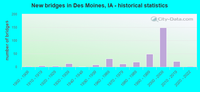
- New bridges - historical statistics
- 21900-1909
- 51910-1919
- 31920-1929
- 131930-1939
- 11940-1949
- 81950-1959
- 311960-1969
- 121970-1979
- 191980-1989
- 491990-1999
- 1492000-2009
- 212010-2019
- 22020-2022
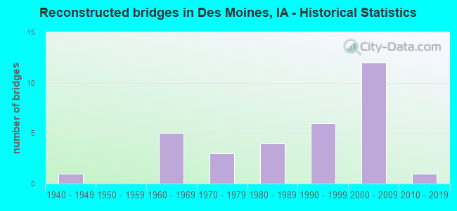
- Reconstructed bridges - Historical Statistics
- 11940-1949
- 01950-1959
- 51960-1969
- 31970-1979
- 41980-1989
- 61990-1999
- 122000-2009
- 12010-2019
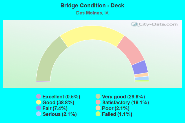
- Bridge Condition - Deck
- 0.5%Excellent
- 29.8%Very good
- 38.8%Good
- 18.1%Satisfactory
- 7.4%Fair
- 2.1%Poor
- 2.1%Serious
- 1.1%Failed
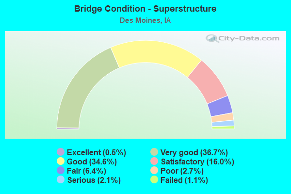
- Bridge Condition - Superstructure
- 0.5%Excellent
- 36.7%Very good
- 34.6%Good
- 16.0%Satisfactory
- 6.4%Fair
- 2.7%Poor
- 2.1%Serious
- 1.1%Failed
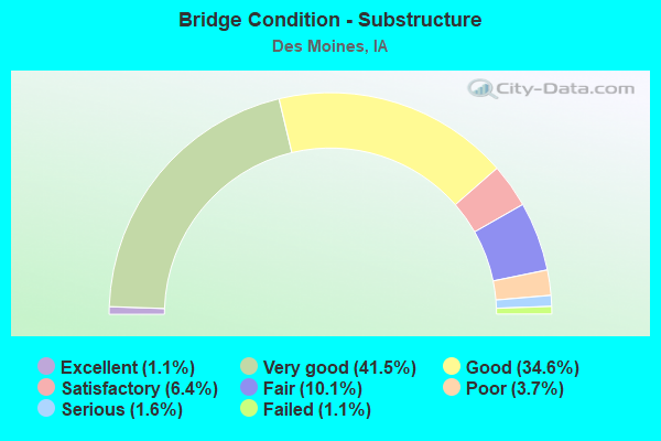
- Bridge Condition - Substructure
- 1.1%Excellent
- 41.5%Very good
- 34.6%Good
- 6.4%Satisfactory
- 10.1%Fair
- 3.7%Poor
- 1.6%Serious
- 1.1%Failed
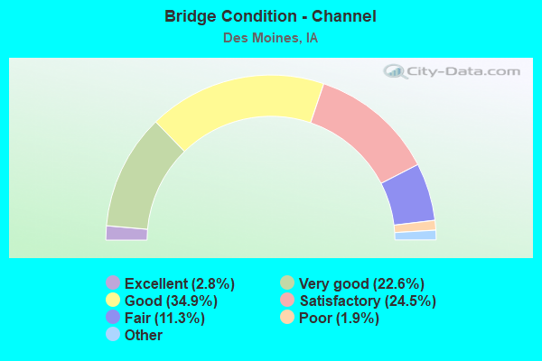
- Bridge Condition - Channel
- 2.8%Excellent
- 22.6%Very good
- 34.9%Good
- 24.5%Satisfactory
- 11.3%Fair
- 1.9%Poor
- 1.9%Serious
- 0.9%Failed
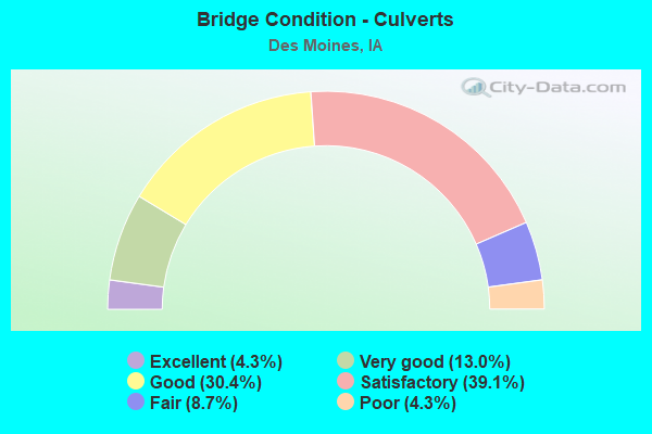
- Bridge Condition - Culverts
- 4.3%Excellent
- 13.0%Very good
- 30.4%Good
- 39.1%Satisfactory
- 8.7%Fair
- 4.3%Poor
Find on map >> Show street view
Structure Number: 3681, Location: 078242700 (Lat: 41.540681, Lng: -93.597900), Route carried "on" structure: City street , Year Built: 1984, Status: Open, Structure Length: 1.34m (4.40ft), Average Daily Traffic: 4,340 (year 2016), Average Future Daily Traffic: 4,340 (year 2041), Design Load: HS 20, Features Intersected: YEADER CREEK, Facility Carried by Structure: E. MCKINLEY AVE
Minimum Vertical Clearance: 30+ m (98+ ft), Kilometerpoint: 1.519, Lanes on structure: 2, Owner: City or Municipal Highway Agency, Approaching Roadway Width: 13.4m (44.0ft), Material/Design: Concrete continuous, Design/Construction: Culvert, Number Of Spans In Main Unit: 2, Length of Maximum Span: 6.1m (20.0ft), Out-to-Out Width: 13.4m (44.0ft)
Condition: Channel: Fair, Culverts: Good, Operating Rating: 44.1 metric tons, Method Used To Determine Operating Rating: Assigned rating based on Load Factor Design (LFD) reported in metric tons, Inventory Rating: 32.7 metric tons, Method Used To Determine Inventory Rating: Assigned rating based on Load Factor Design (LFD) reported in metric tons, Structural Evaluation: Better than present minimum criteria, Waterway Adequacy: Somewhat better than minimum adequacy, Approach Roadway Alignment: Equal to present desirable criteria, Length Of Structure Improvement: 4.40m (14.44ft), Designated Inspection Frequency: Every 24 months, Inspection Date: July 2021, Bridge Improvement Cost: $15,000, Roadway Improvement Cost: $2,000
Find on map >> Show street view
Structure Number: 3683, Location: 078252400 (Lat: 41.555536, Lng: -93.680217), Route carried "on" structure: City street , Year Built: 1997, Status: Open, Structure Length: 1.59m (5.22ft), Average Daily Traffic: 15,500 (year 2016), Average Future Daily Traffic: 15,500 (year 2041), Design Load: HS 20, Features Intersected: FRINK CREEK, Facility Carried by Structure: PARK AVE
Minimum Vertical Clearance: 30+ m (98+ ft), Kilometerpoint: 1.942, Lanes on structure: 2, Owner: City or Municipal Highway Agency, Approaching Roadway Width: 13.4m (44.0ft), Skew: 3 degrees, Material/Design: Concrete continuous, Design/Construction: Culvert, Number Of Spans In Main Unit: 3, Length of Maximum Span: 4.3m (14.1ft)
Condition: Channel: Good, Culverts: Good, Operating Rating: 44.1 metric tons, Method Used To Determine Operating Rating: Assigned rating based on Load Factor Design (LFD) reported in metric tons, Inventory Rating: 32.7 metric tons, Method Used To Determine Inventory Rating: Assigned rating based on Load Factor Design (LFD) reported in metric tons, Structural Evaluation: Better than present minimum criteria, Waterway Adequacy: Equal to present minimum criteria, Approach Roadway Alignment: Equal to present desirable criteria, Length Of Structure Improvement: 5.20m (17.06ft), Designated Inspection Frequency: Every 24 months, Inspection Date: July 2021, Bridge Improvement Cost: $15,000, Roadway Improvement Cost: $2,000
Find on map >> Show street view
Structure Number: 3684, Location: 078241000 (Lat: 41.578647, Lng: -93.612231), Route carried "on" structure: City street , Year Built: 1937, Year Reconstructed: 2021, Status: Open, Structure Length: 22.77m (74.70ft), Average Daily Traffic: 4,590 (year 2012), Average Future Daily Traffic: 4,590 (year 2041), Design Load: H 20, Features Intersected: DES MOINES RIVER, Facility Carried by Structure: SCOTT AVE
Minimum Vertical Clearance: 30+ m (98+ ft), Kilometerpoint: 1.075, Lanes on structure: 2, Owner: City or Municipal Highway Agency, Approaching Roadway Width: 11.0m (36.1ft), Material/Design: Concrete continuous, Design/Construction: Arch - Deck, Number Of Spans In Main Unit: 8, Length of Maximum Span: 26.5m (86.9ft), Curb or Sidewalk Widths: Left: 2.4m (7.9ft), Right: 0.0m, Curb-To-Curb Width: 14.9m (48.9ft), Out-to-Out Width: 18.6m (61.0ft)
Condition: Deck: Satisfactory, Superstructure: Fair, Substructure: Fair, Channel: Satisfactory, Operating Rating: 66.0 metric tons, Method Used To Determine Operating Rating: Load Factor (LF), Inventory Rating: 39.5 metric tons, Method Used To Determine Inventory Rating: Load Factor (LF), Structural Evaluation: Somewhat better than minimum adequacy, Deck Geometry: Superior to present desirable criteria, Waterway Adequacy: Better than present minimum criteria, Approach Roadway Alignment: Better than present minimum criteria, Length Of Structure Improvement: 74.70m (245.08ft), Designated Inspection Frequency: Every 24 months, Inspection Date: July 2021, Bridge Improvement Cost: $1,000,000, Roadway Improvement Cost: $100,000, Deck Structure Type: Concrete Cast-file-Place, Wearing Surface/Protective System: Wearing Surface: Low Slump Concrete
Find on map >> Show street view
Structure Number: 3687, Location: 078230700 (Lat: 41.583950, Lng: -93.551956), Route carried "on" structure: City street , Year Built: 2010, Status: Open, Structure Length: 1.22m (4.00ft), Average Daily Traffic: 2,790 (year 2016), Average Future Daily Traffic: 2,790 (year 2041), Design Load: HS 20, Features Intersected: LEE TOWN CREEKWAY, Facility Carried by Structure: SCOTT AVE
Minimum Vertical Clearance: 30+ m (98+ ft), Kilometerpoint: 3.991, Lanes on structure: 2, Owner: City or Municipal Highway Agency, Approaching Roadway Width: 8.5m (27.9ft), Skew: 1 degrees, Material/Design: Concrete continuous, Design/Construction: Culvert, Number Of Spans In Main Unit: 3, Length of Maximum Span: 3.7m (12.1ft), Curb or Sidewalk Widths: Left: 1.5m (4.9ft), Right: 0.0m, Curb-To-Curb Width: 9.4m (30.8ft), Out-to-Out Width: 9.4m (30.8ft)
Condition: Channel: Very good, Culverts: Good, Operating Rating: 44.1 metric tons, Method Used To Determine Operating Rating: Assigned rating based on Load Factor Design (LFD) reported in metric tons, Inventory Rating: 32.7 metric tons, Method Used To Determine Inventory Rating: Assigned rating based on Load Factor Design (LFD) reported in metric tons, Structural Evaluation: Better than present minimum criteria, Deck Geometry: Meets minimum limits, Waterway Adequacy: Equal to present desirable criteria, Approach Roadway Alignment: Equal to present desirable criteria, Designated Inspection Frequency: Every 24 months, Inspection Date: July 2021
Find on map >> Show street view
Structure Number: 3689, Location: F20610970 (Lat: 41.583183, Lng: -93.533314), Route carried "on" structure: City street , Year Built: 1993, Status: Open, Structure Length: 7.41m (24.31ft), Average Daily Traffic: 2,860 (year 2016), Average Future Daily Traffic: 2,860 (year 2041), Design Load: HS 20, Features Intersected: FOUR MILE CREEK, Facility Carried by Structure: SCOTT AVE
Minimum Vertical Clearance: 30+ m (98+ ft), Kilometerpoint: 5.549, Lanes on structure: 2, Owner: City or Municipal Highway Agency, Approaching Roadway Width: 11.9m (39.0ft), Skew: 1 degrees, Material/Design: Prestressed concrete, Design/Construction: Stringer/Multi-beam, Number Of Spans In Main Unit: 3, Length of Maximum Span: 24.7m (81.0ft), Curb-To-Curb Width: 11.0m (36.1ft), Out-to-Out Width: 13.7m (44.9ft)
Condition: Deck: Satisfactory, Superstructure: Very good, Substructure: Good, Channel: Satisfactory, Operating Rating: 86.5 metric tons, Method Used To Determine Operating Rating: Load Factor (LF), Inventory Rating: 51.9 metric tons, Method Used To Determine Inventory Rating: Load Factor (LF), Structural Evaluation: Better than present minimum criteria, Deck Geometry: Somewhat better than minimum adequacy, Waterway Adequacy: Equal to present desirable criteria, Approach Roadway Alignment: Better than present minimum criteria, Length Of Structure Improvement: 24.30m (79.72ft), Designated Inspection Frequency: Every 24 months, Inspection Date: July 2021, Bridge Improvement Cost: $15,000, Roadway Improvement Cost: $2,000, Deck Structure Type: Concrete Cast-file-Place
Find on map >> Show street view
Structure Number: 369, Location: 000000000 (Lat: 41.585892, Lng: -93.617586), Route carried "on" structure: City street , Year Built: 1918, Year Reconstructed: 1982, Status: Open, Structure Length: 15.12m (49.61ft), Average Daily Traffic: 9,900 (year 1992), Average Future Daily Traffic: 9,900 (year 2041), Design Load: HS 20, Features Intersected: DES MOINES RIVER, Facility Carried by Structure: COURT AVE
Minimum Vertical Clearance: 30+ m (98+ ft), Kilometerpoint: 0.459, Lanes on structure: 4, Owner: City or Municipal Highway Agency, Approaching Roadway Width: 12.2m (40.0ft), Material/Design: Concrete continuous, Design/Construction: Arch - Deck, Number Of Spans In Main Unit: 5, Length of Maximum Span: 28.0m (91.9ft), Curb or Sidewalk Widths: Left: 4.6m (15.1ft), Right: 4.6m (15.1ft), Curb-To-Curb Width: 21.0m (68.9ft), Out-to-Out Width: 30.8m (101.0ft)
Condition: Deck: Satisfactory, Superstructure: Satisfactory, Substructure: Fair, Channel: Good, Operating Rating: 44.1 metric tons, Method Used To Determine Operating Rating: Load Factor (LF), Inventory Rating: 26.4 metric tons, Method Used To Determine Inventory Rating: Load Factor (LF), Structural Evaluation: Somewhat better than minimum adequacy, Deck Geometry: Superior to present desirable criteria, Waterway Adequacy: Equal to present minimum criteria, Approach Roadway Alignment: Better than present minimum criteria, Length Of Structure Improvement: 49.60m (162.73ft), Designated Inspection Frequency: Every 24 months, Inspection Date: July 2021, Bridge Improvement Cost: $150,000, Roadway Improvement Cost: $15,000, Deck Structure Type: Concrete Cast-file-Place, Wearing Surface/Protective System: Wearing Surface: Monolithic Concrete
Find on map >> Show street view
Structure Number: 37, Location: 078240400 (Lat: 41.587239, Lng: -93.618278), Route carried "on" structure: City street , Year Built: 1911, Year Reconstructed: 1966, Status: Open, Structure Length: 15.33m (50.30ft), Average Daily Traffic: 4,080 (year 2016), Average Future Daily Traffic: 4,080 (year 2041), Design Load: H 20, Features Intersected: DES MOINES RIVER, Facility Carried by Structure: WALNUT ST
Minimum Vertical Clearance: 30+ m (98+ ft), Kilometerpoint: 1.670, Lanes on structure: 4, Owner: City or Municipal Highway Agency, Approaching Roadway Width: 16.5m (54.1ft), Material/Design: Concrete continuous, Design/Construction: Arch - Deck, Number Of Spans In Main Unit: 6, Length of Maximum Span: 22.9m (75.1ft), Curb or Sidewalk Widths: Left: 2.4m (7.9ft), Right: 2.4m (7.9ft), Curb-To-Curb Width: 20.7m (67.9ft), Out-to-Out Width: 25.9m (85.0ft)
Condition: Deck: Serious, Superstructure: Serious, Substructure: Poor, Channel: Good, Operating Rating: 21.4 metric tons, Method Used To Determine Operating Rating: Load Factor (LF), Inventory Rating: 12.9 metric tons, Method Used To Determine Inventory Rating: Load Factor (LF), Structural Evaluation: High priority of corrective action, Deck Geometry: Superior to present desirable criteria, Waterway Adequacy: Equal to present minimum criteria, Approach Roadway Alignment: Better than present minimum criteria, Length Of Structure Improvement: 50.30m (165.03ft), Designated Inspection Frequency: Every 24 months, Underwater Inspection Frequency: Every 60 months, Inspection Date: July 2021, Underwater Inspection Date: August 2017, Bridge Improvement Cost: $200,000, Roadway Improvement Cost: $20,000, Deck Structure Type: Concrete Cast-file-Place, Wearing Surface/Protective System: Wearing Surface: Bituminous
Find on map >> Show street view
Structure Number: 3711, Location: 078240400 (Lat: 41.588161, Lng: -93.618642), Route carried "on" structure: City street , Year Built: 2020, Status: Open, Structure Length: 13.69m (44.91ft), Average Daily Traffic: 6,400 (year 2016), Average Future Daily Traffic: 6,400 (year 2041), Design Load: HL 93, Features Intersected: DES MOINES RIVER, Facility Carried by Structure: EAST LOCUST ST
Minimum Vertical Clearance: 30+ m (98+ ft), Kilometerpoint: 1.926, Lanes on structure: 2, Owner: City or Municipal Highway Agency, Approaching Roadway Width: 12.8m (42.0ft), Material/Design: Prestressed concrete, Design/Construction: Stringer/Multi-beam, Number Of Spans In Main Unit: 4, Length of Maximum Span: 37.2m (122.0ft), Curb or Sidewalk Widths: Left: 0.0m, Right: 3.7m (12.1ft), Curb-To-Curb Width: 12.8m (42.0ft), Out-to-Out Width: 21.1m (69.2ft)
Condition: Deck: Very good, Superstructure: Very good, Substructure: Very good, Channel: Good, Operating Rating: 66.4 metric tons, Method Used To Determine Operating Rating: Load and Resistance Factor Rating (LRFR) rating reported by rating factor(RF) method using HL-93 loadings, Inventory Rating: 42.4 metric tons, Method Used To Determine Inventory Rating: Load and Resistance Factor Rating (LRFR) rating reported by rating factor(RF) method using HL-93 loadings, Structural Evaluation: Equal to present desirable criteria, Deck Geometry: Somewhat better than minimum adequacy, Waterway Adequacy: Equal to present desirable criteria, Approach Roadway Alignment: Better than present minimum criteria, Designated Inspection Frequency: Every 24 months, Inspection Date: July 2021, Deck Structure Type: Concrete Cast-file-Place, Wearing Surface/Protective System: Wearing Surface: Monolithic Concrete, Deck Protection: Epoxy Coated Reinforcing
Find on map >> Show street view
Structure Number: 3715, Location: 078240700 (Lat: 41.579503, Lng: -93.664006), Route carried "on" structure: City street , Year Built: 1900, Status: Open, Structure Length: 1.22m (4.00ft), Average Daily Traffic: 853 (year 1998), Average Future Daily Traffic: 853 (year 2041), Features Intersected: DRAINAGE, Facility Carried by Structure: ST JOHNS RD
Minimum Vertical Clearance: 30+ m (98+ ft), Kilometerpoint: 0.249, Lanes on structure: 2, Owner: City or Municipal Highway Agency, Approaching Roadway Width: 7.3m (24.0ft), Material/Design: Concrete, Design/Construction: Arch - Deck, Number Of Spans In Main Unit: 1, Length of Maximum Span: 6.1m (20.0ft), Curb or Sidewalk Widths: Left: 0.0m, Right: 1.2m (3.9ft), Curb-To-Curb Width: 7.3m (24.0ft), Out-to-Out Width: 12.3m (40.4ft)
Condition: Deck: Satisfactory, Superstructure: Poor, Substructure: Fair, Channel: Satisfactory, Operating Rating: 24.4 metric tons, Method Used To Determine Operating Rating: Load Factor (LF), Inventory Rating: 14.6 metric tons, Method Used To Determine Inventory Rating: Load Factor (LF), Structural Evaluation: Meets minimum limits, Deck Geometry: Meets minimum limits, Waterway Adequacy: Equal to present minimum criteria, Approach Roadway Alignment: Meets minimum limits, Length Of Structure Improvement: 4.00m (13.12ft), Designated Inspection Frequency: Every 24 months, Inspection Date: July 2021, Bridge Improvement Cost: $15,000, Roadway Improvement Cost: $2,000, Deck Structure Type: Concrete Cast-file-Place, Wearing Surface/Protective System: Wearing Surface: Bituminous
Find on map >> Show street view
Structure Number: 3722, Location: 078240400 (Lat: 41.589125, Lng: -93.618858), Route carried "on" structure: City street , Year Built: 2017, Status: Open, Structure Length: 13.59m (44.59ft), Average Daily Traffic: 8,200 (year 2012), Average Future Daily Traffic: 8,200 (year 2041), Design Load: HL 93, Features Intersected: DES MOINES RIVER, Facility Carried by Structure: GRAND AVE
Minimum Vertical Clearance: 30+ m (98+ ft), Kilometerpoint: 5.470, Lanes on structure: 4, Owner: City or Municipal Highway Agency, Approaching Roadway Width: 16.5m (54.1ft), Material/Design: Prestressed concrete, Design/Construction: Stringer/Multi-beam, Number Of Spans In Main Unit: 4, Length of Maximum Span: 36.6m (120.1ft), Curb or Sidewalk Widths: Left: 4.3m (14.1ft), Right: 4.3m (14.1ft), Curb-To-Curb Width: 16.5m (54.1ft), Out-to-Out Width: 26.0m (85.3ft)
Condition: Deck: Very good, Superstructure: Very good, Substructure: Very good, Channel: Good, Operating Rating: 69.7 metric tons, Method Used To Determine Operating Rating: Load and Resistance Factor Rating (LRFR) rating reported by rating factor(RF) method using HL-93 loadings, Inventory Rating: 47.3 metric tons, Method Used To Determine Inventory Rating: Load and Resistance Factor Rating (LRFR) rating reported by rating factor(RF) method using HL-93 loadings, Structural Evaluation: Equal to present desirable criteria, Deck Geometry: Meets minimum limits, Waterway Adequacy: Superior to present desirable criteria, Approach Roadway Alignment: Better than present minimum criteria, Designated Inspection Frequency: Every 24 months, Inspection Date: July 2021, Deck Structure Type: Concrete Cast-file-Place, Wearing Surface/Protective System: Wearing Surface: Monolithic Concrete, Membrane: Built-up, Deck Protection: Epoxy Coated Reinforcing
Find on map >> Show street view
Structure Number: 3732, Location: GRAND AVENUE (Lat: 41.582697, Lng: -93.703222), Route carried "on" structure: City street , Year Built: 2013, Status: Open, Structure Length: 5.12m (16.80ft), Average Daily Traffic: 15,800 (year 2016), Average Future Daily Traffic: 15,800 (year 2041), Design Load: HL 93, Features Intersected: WALNUT CREEK, Facility Carried by Structure: GRAND AVE
Minimum Vertical Clearance: 30+ m (98+ ft), Kilometerpoint: 0.016, Lanes on structure: 5, Owner: City or Municipal Highway Agency, Approaching Roadway Width: 21.0m (68.9ft), Skew: 1 degrees, Material/Design: Concrete continuous, Design/Construction: Slab, Number Of Spans In Main Unit: 3, Length of Maximum Span: 19.8m (65.0ft), Curb or Sidewalk Widths: Left: 1.5m (4.9ft), Right: 2.4m (7.9ft), Curb-To-Curb Width: 21.0m (68.9ft), Out-to-Out Width: 26.2m (86.0ft)
Condition: Deck: Good, Superstructure: Good, Substructure: Very good, Channel: Very good, Operating Rating: 42.1 metric tons, Method Used To Determine Operating Rating: Assigned ratings based on Load and Resistance Factor Design (LRFD) reported by rating factor (RF) using HL93 loadings, Inventory Rating: 32.4 metric tons, Method Used To Determine Inventory Rating: Assigned ratings based on Load and Resistance Factor Design (LRFD) reported by rating factor (RF) using HL93 loadings, Structural Evaluation: Better than present minimum criteria, Deck Geometry: Somewhat better than minimum adequacy, Waterway Adequacy: Equal to present desirable criteria, Approach Roadway Alignment: Somewhat better than minimum adequacy, Designated Inspection Frequency: Every 24 months, Inspection Date: July 2021, Deck Structure Type: Concrete Cast-file-Place, Wearing Surface/Protective System: Wearing Surface: Monolithic Concrete, Deck Protection: Epoxy Coated Reinforcing
Find on map >> Show street view
Structure Number: 374, Location: 079232901 (Lat: 41.625553, Lng: -93.551419), Route carried "on" structure: City street , Year Built: 2002, Status: Open, Structure Length: 5.61m (18.41ft), Average Daily Traffic: 8,930 (year 2016), Average Future Daily Traffic: 8,930 (year 2041), Design Load: HS 20, Features Intersected: FOUR MILE CREEK, Facility Carried by Structure: HUBBELL AVE
Minimum Vertical Clearance: 30+ m (98+ ft), Kilometerpoint: 4.609, Lanes on structure: 5, Owner: City or Municipal Highway Agency, Approaching Roadway Width: 20.7m (67.9ft), Skew: 3 degrees, Material/Design: Concrete continuous, Design/Construction: Slab, Number Of Spans In Main Unit: 4, Length of Maximum Span: 15.5m (50.9ft), Curb or Sidewalk Widths: Left: 3.0m (9.8ft), Right: 1.5m (4.9ft), Curb-To-Curb Width: 20.7m (67.9ft), Out-to-Out Width: 26.7m (87.6ft)
Condition: Deck: Satisfactory, Superstructure: Satisfactory, Substructure: Good, Channel: Good, Inventory Rating: 53.8 metric tons, Method Used To Determine Inventory Rating: Load Factor (LF), Structural Evaluation: Equal to present minimum criteria, Deck Geometry: Somewhat better than minimum adequacy, Waterway Adequacy: Better than present minimum criteria, Approach Roadway Alignment: Equal to present desirable criteria, Length Of Structure Improvement: 18.10m (59.38ft), Designated Inspection Frequency: Every 24 months, Inspection Date: July 2021, Bridge Improvement Cost: $15,000, Roadway Improvement Cost: $2,000, Deck Structure Type: Concrete Cast-file-Place, Wearing Surface/Protective System: Wearing Surface: Monolithic Concrete, Deck Protection: Epoxy Coated Reinforcing
Find on map >> Show street view
Structure Number: 3762, Location: 0792332 (Lat: 41.613917, Lng: -93.545533), Route carried "on" structure: City street , Year Built: 2011, Status: Open, Structure Length: 4.88m (16.01ft), Average Daily Traffic: 8,600 (year 2012), Average Future Daily Traffic: 8,600 (year 2041), Design Load: HS 20, Features Intersected: FOUR MILE CREEK, Facility Carried by Structure: EASTON BLVD
Minimum Vertical Clearance: 30+ m (98+ ft), Kilometerpoint: 3.916, Lanes on structure: 2, Owner: City or Municipal Highway Agency, Approaching Roadway Width: 10.4m (34.1ft), Material/Design: Concrete continuous, Design/Construction: Slab, Number Of Spans In Main Unit: 4, Length of Maximum Span: 13.7m (44.9ft), Curb or Sidewalk Widths: Left: 4.3m (14.1ft), Right: 6.1m (20.0ft), Curb-To-Curb Width: 12.8m (42.0ft), Out-to-Out Width: 19.1m (62.7ft)
Condition: Deck: Good, Superstructure: Good, Substructure: Good, Channel: Good, Inventory Rating: 55.3 metric tons, Method Used To Determine Inventory Rating: Load Factor (LF), Structural Evaluation: Better than present minimum criteria, Deck Geometry: Somewhat better than minimum adequacy, Waterway Adequacy: Equal to present desirable criteria, Approach Roadway Alignment: Equal to present desirable criteria, Designated Inspection Frequency: Every 24 months, Inspection Date: July 2021, Deck Structure Type: Concrete Cast-file-Place, Wearing Surface/Protective System: Wearing Surface: Monolithic Concrete, Deck Protection: Epoxy Coated Reinforcing
Find on map >> Show street view
Structure Number: 377, Location: 078240300 (Lat: 41.600367, Lng: -93.615283), Route carried "on" structure: City street , Year Built: 1920, Year Reconstructed: 2004, Status: Open, Structure Length: 25.88m (84.91ft), Average Daily Traffic: 17,300 (year 2016), Average Future Daily Traffic: 17,300 (year 2041), Design Load: H 20, Features Intersected: DES MOINES RIVER, Facility Carried by Structure: UNIV AVE
Minimum Vertical Clearance: 30+ m (98+ ft), Kilometerpoint: 0.011, Lanes on structure: 4, Owner: City or Municipal Highway Agency, Approaching Roadway Width: 12.8m (42.0ft), Material/Design: Concrete continuous, Design/Construction: Arch - Deck, Number Of Spans In Main Unit: 6, Length of Maximum Span: 52.7m (172.9ft), Curb or Sidewalk Widths: Left: 1.5m (4.9ft), Right: 1.5m (4.9ft), Curb-To-Curb Width: 15.2m (49.9ft), Out-to-Out Width: 18.9m (62.0ft)
Condition: Deck: Fair, Superstructure: Fair, Substructure: Fair, Channel: Good, Operating Rating: 44.7 metric tons, Method Used To Determine Operating Rating: Load Factor (LF), Inventory Rating: 26.8 metric tons, Method Used To Determine Inventory Rating: Load Factor (LF), Structural Evaluation: Somewhat better than minimum adequacy, Deck Geometry: High priority of corrective action, Waterway Adequacy: Better than present minimum criteria, Approach Roadway Alignment: Better than present minimum criteria, Length Of Structure Improvement: 84.90m (278.54ft), Designated Inspection Frequency: Every 24 months, Underwater Inspection Frequency: Every 60 months, Inspection Date: July 2021, Underwater Inspection Date: September 2017, Bridge Improvement Cost: $100,000, Roadway Improvement Cost: $10,000, Deck Structure Type: Concrete Cast-file-Place, Wearing Surface/Protective System: Wearing Surface: Low Slump Concrete
Find on map >> Show street view
Structure Number: 3773, Location: 078240500 (Lat: 41.600425, Lng: -93.638717), Route carried "on" structure: City street , Year Built: 1987, Status: Open, Structure Length: 3.23m (10.60ft), Average Daily Traffic: 14,900 (year 2012), Average Future Daily Traffic: 14,900 (year 2041), Design Load: HS 20, Features Intersected: KEOSAUQUA, Facility Carried by Structure: UNIV AVE
Minimum Vertical Clearance: 30+ m (98+ ft), Kilometerpoint: 5.419, Lanes on structure: 4, Lanes under structure: 4, Owner: City or Municipal Highway Agency, Approaching Roadway Width: 16.5m (54.1ft), Skew: 4 degrees, Material/Design: Prestressed concrete, Design/Construction: Stringer/Multi-beam, Number Of Spans In Main Unit: 1, Length of Maximum Span: 31.1m (102.0ft), Curb or Sidewalk Widths: Left: 1.5m (4.9ft), Right: 1.5m (4.9ft), Curb-To-Curb Width: 16.5m (54.1ft), Out-to-Out Width: 21.0m (68.9ft)
Condition: Deck: Fair, Superstructure: Good, Substructure: Fair, Operating Rating: 84.2 metric tons, Method Used To Determine Operating Rating: Load Factor (LF), Inventory Rating: 45.0 metric tons, Method Used To Determine Inventory Rating: Load Factor (LF), Structural Evaluation: Somewhat better than minimum adequacy, Deck Geometry: Meets minimum limits, Underclear: Meets minimum limits, Approach Roadway Alignment: Better than present minimum criteria, Length Of Structure Improvement: 10.20m (33.46ft), Designated Inspection Frequency: Every 24 months, Inspection Date: July 2021, Bridge Improvement Cost: $15,000, Roadway Improvement Cost: $2,000, Deck Structure Type: Concrete Cast-file-Place, Wearing Surface/Protective System: Wearing Surface: Monolithic Concrete
Find on map >> Show street view
Structure Number: 378, Location: 000000000 (Lat: 41.603983, Lng: -93.666731), Route carried "on" structure: City street , Year Built: 1900, Year Reconstructed: 1981, Status: Open, Structure Length: 2.41m (7.91ft), Average Daily Traffic: 2,770 (year 2016), Average Future Daily Traffic: 2,770 (year 2041), Design Load: HS 20, Features Intersected: CLOSES CREEK, Facility Carried by Structure: FOREST AVE
Minimum Vertical Clearance: 30+ m (98+ ft), Kilometerpoint: 2.105, Lanes on structure: 2, Owner: City or Municipal Highway Agency, Approaching Roadway Width: 9.4m (30.8ft), Material/Design: Prestressed concrete, Design/Construction: Stringer/Multi-beam, Number Of Spans In Main Unit: 1, Length of Maximum Span: 23.2m (76.1ft), Curb or Sidewalk Widths: Left: 1.5m (4.9ft), Right: 1.5m (4.9ft), Curb-To-Curb Width: 9.4m (30.8ft), Out-to-Out Width: 14.1m (46.3ft)
Condition: Deck: Fair, Superstructure: Satisfactory, Substructure: Fair, Channel: Good, Operating Rating: 89.1 metric tons, Method Used To Determine Operating Rating: Load Factor (LF), Inventory Rating: 50.2 metric tons, Method Used To Determine Inventory Rating: Load Factor (LF), Structural Evaluation: Somewhat better than minimum adequacy, Deck Geometry: Meets minimum limits, Waterway Adequacy: Equal to present desirable criteria, Approach Roadway Alignment: Better than present minimum criteria, Length Of Structure Improvement: 7.90m (25.92ft), Designated Inspection Frequency: Every 24 months, Inspection Date: July 2021, Bridge Improvement Cost: $15,000, Roadway Improvement Cost: $2,000, Deck Structure Type: Concrete Cast-file-Place, Wearing Surface/Protective System: Wearing Surface: Monolithic Concrete, Deck Protection: Epoxy Coated Reinforcing
Find on map >> Show street view
Structure Number: 3796, Location: 000000000 (Lat: 41.629572, Lng: -93.548211), Route carried "on" structure: City street , Year Built: 1999, Status: Open, Structure Length: 5.40m (17.72ft), Average Daily Traffic: 870 (year 2016), Average Future Daily Traffic: 870 (year 2041), Design Load: HS 20, Features Intersected: FOUR MILE CREEK, Facility Carried by Structure: E DOUGLAS AVE
Minimum Vertical Clearance: 30+ m (98+ ft), Kilometerpoint: 3.510, Lanes on structure: 2, Owner: City or Municipal Highway Agency, Approaching Roadway Width: 7.9m (25.9ft), Skew: 1 degrees, Material/Design: Concrete continuous, Design/Construction: Slab, Number Of Spans In Main Unit: 4, Length of Maximum Span: 14.9m (48.9ft), Curb or Sidewalk Widths: Left: 0.0m, Right: 2.4m (7.9ft), Curb-To-Curb Width: 9.8m (32.2ft), Out-to-Out Width: 13.3m (43.6ft)
Condition: Deck: Satisfactory, Superstructure: Satisfactory, Substructure: Very good, Channel: Good, Operating Rating: 87.3 metric tons, Method Used To Determine Operating Rating: Load Factor (LF), Inventory Rating: 52.2 metric tons, Method Used To Determine Inventory Rating: Load Factor (LF), Structural Evaluation: Equal to present minimum criteria, Deck Geometry: Equal to present minimum criteria, Waterway Adequacy: Equal to present desirable criteria, Approach Roadway Alignment: Better than present minimum criteria, Length Of Structure Improvement: 17.40m (57.09ft), Designated Inspection Frequency: Every 24 months, Inspection Date: July 2021, Bridge Improvement Cost: $15,000, Roadway Improvement Cost: $2,000, Deck Structure Type: Concrete Cast-file-Place, Wearing Surface/Protective System: Wearing Surface: Monolithic Concrete, Deck Protection: Epoxy Coated Reinforcing
Find on map >> Show street view
Structure Number: 39, Location: 078241700 (Lat: 41.565753, Lng: -93.644914), Route carried "on" structure: City street , Year Built: 1936, Year Reconstructed: 2011, Status: Open, Structure Length: 7.35m (24.11ft), Average Daily Traffic: 16,600 (year 2016), Average Future Daily Traffic: 16,600 (year 2041), Design Load: HS 20, Features Intersected: OLD UP RR & SW 22ND, Facility Carried by Structure: FLEUR DR
Minimum Vertical Clearance: 30+ m (98+ ft), Kilometerpoint: 7.960, Lanes on structure: 4, Lanes under structure: 2, Base Highway Network: Yes, Owner: City or Municipal Highway Agency, Approaching Roadway Width: 19.2m (63.0ft), Skew: 21 degrees, Material/Design: Steel continuous, Design/Construction: Stringer/Multi-beam, Number Of Spans In Main Unit: 4, Length of Maximum Span: 23.5m (77.1ft), Curb or Sidewalk Widths: Left: 1.5m (4.9ft), Right: 1.5m (4.9ft), Curb-To-Curb Width: 16.5m (54.1ft), Out-to-Out Width: 22.2m (72.8ft)
Condition: Deck: Good, Superstructure: Good, Substructure: Fair, Operating Rating: 49.0 metric tons, Method Used To Determine Operating Rating: Load Factor (LF), Inventory Rating: 29.3 metric tons, Method Used To Determine Inventory Rating: Load Factor (LF), Structural Evaluation: Somewhat better than minimum adequacy, Deck Geometry: Meets minimum limits, Approach Roadway Alignment: Equal to present desirable criteria, Length Of Structure Improvement: 23.60m (77.43ft), Designated Inspection Frequency: Every 24 months, Inspection Date: August 2021, Bridge Improvement Cost: $1,869,000, Roadway Improvement Cost: $187,000, Deck Structure Type: Concrete Cast-file-Place, Wearing Surface/Protective System: Wearing Surface: Monolithic Concrete
Find on map >> Show street view
Structure Number: 391, Location: 078240800 (Lat: 41.581461, Lng: -93.642806), Route carried "on" structure: City street , Year Built: 1936, Year Reconstructed: 2008, Status: Open, Structure Length: 28.86m (94.69ft), Average Daily Traffic: 3,000 (year 2016), Average Future Daily Traffic: 3,000 (year 2041), Design Load: HS 20, Features Intersected: RACCOON AND RR, Facility Carried by Structure: FLEUR DR
Minimum Vertical Clearance: 30+ m (98+ ft), Kilometerpoint: 9.737, Lanes on structure: 4, Owner: City or Municipal Highway Agency, Approaching Roadway Width: 18.3m (60.0ft), Skew: 21 degrees, Material/Design: Steel continuous, Design/Construction: Girder and Floorbeam System, Number Of Spans In Main Unit: 11, Number Of Approach Spans: 2, Length of Maximum Span: 33.5m (109.9ft), Curb or Sidewalk Widths: Left: 1.5m (4.9ft), Right: 1.5m (4.9ft), Curb-To-Curb Width: 17.7m (58.1ft), Out-to-Out Width: 21.9m (71.9ft)
Condition: Deck: Fair, Superstructure: Fair, Substructure: Poor, Channel: Good, Operating Rating: 34.9 metric tons, Method Used To Determine Operating Rating: Load Factor (LF), Inventory Rating: 20.9 metric tons, Method Used To Determine Inventory Rating: Load Factor (LF), Structural Evaluation: Meets minimum limits, Deck Geometry: Somewhat better than minimum adequacy, Underclear: Meets minimum limits, Waterway Adequacy: Somewhat better than minimum adequacy, Approach Roadway Alignment: Better than present minimum criteria, Length Of Structure Improvement: 94.70m (310.70ft), Designated Inspection Frequency: Every 24 months, Underwater Inspection Frequency: Every 60 months, Inspection Date: July 2021, Underwater Inspection Date: August 2017, Bridge Improvement Cost: $1,000,000, Roadway Improvement Cost: $100,000, Deck Structure Type: Concrete Cast-file-Place, Wearing Surface/Protective System: Wearing Surface: Monolithic Concrete
Find on map >> Show street view
Structure Number: 3974, Location: 078240900 (Lat: 41.579881, Lng: -93.625050), Route carried "on" structure: City street , Year Built: 1967, Year Reconstructed: 2006, Status: Open, Structure Length: 46.18m (151.51ft), Average Daily Traffic: 7,300 (year 2016), Average Future Daily Traffic: 7,300 (year 2041), Design Load: HS 20, Features Intersected: RR, CHERRY, MLK JR PKWY, Facility Carried by Structure: SW 8TH ST
Minimum Vertical Clearance: 30+ m (98+ ft), Kilometerpoint: 2.063, Lanes on structure: 2, Lanes under structure: 6, Owner: City or Municipal Highway Agency, Approaching Roadway Width: 12.5m (41.0ft), Material/Design: Steel continuous, Design/Construction: Girder and Floorbeam System, Number Of Spans In Main Unit: 3, Number Of Approach Spans: 14, Length of Maximum Span: 47.9m (157.2ft), Curb-To-Curb Width: 7.9m (25.9ft), Out-to-Out Width: 9.5m (31.2ft)
Condition: Deck: Fair, Superstructure: Poor, Substructure: Fair, Operating Rating: 60.0 metric tons, Method Used To Determine Operating Rating: Load Factor (LF), Inventory Rating: 33.9 metric tons, Method Used To Determine Inventory Rating: Load Factor (LF), Structural Evaluation: Meets minimum limits, Deck Geometry: High priority of replacement, Underclear: High priority of corrective action, Approach Roadway Alignment: Equal to present minimum criteria, Length Of Structure Improvement: 151.50m (497.05ft), Designated Inspection Frequency: Every 24 months, Critical Feature Inspection Frequency: Every 24 months, Inspection Date: July 2021, Critical Feature Inspection Date: July 2021, Bridge Improvement Cost: $20,000, Roadway Improvement Cost: $2,000, Deck Structure Type: Concrete Cast-file-Place, Wearing Surface/Protective System: Wearing Surface: Bituminous
Find on map >> Show street view
Structure Number: 398, Location: 000000000 (Lat: 41.573258, Lng: -93.621289), Route carried "on" structure: City street , Year Built: 1915, Year Reconstructed: 1968, Status: Open, Structure Length: 24.35m (79.89ft), Average Daily Traffic: 7,700 (year 2016), Average Future Daily Traffic: 7,700 (year 2041), Design Load: H 20, Features Intersected: RACCOON R & TRAIL, Facility Carried by Structure: SW 7TH ST
Minimum Vertical Clearance: 30+ m (98+ ft), Kilometerpoint: 2.758, Lanes on structure: 4, Owner: City or Municipal Highway Agency, Approaching Roadway Width: 13.1m (43.0ft), Skew: 3 degrees, Material/Design: Concrete continuous, Design/Construction: Arch - Deck, Number Of Spans In Main Unit: 4, Number Of Approach Spans: 7, Length of Maximum Span: 37.2m (122.0ft), Curb or Sidewalk Widths: Left: 0.0m, Right: 1.5m (4.9ft), Curb-To-Curb Width: 15.2m (49.9ft), Out-to-Out Width: 17.8m (58.4ft)
Condition: Deck: Fair, Superstructure: Fair, Substructure: Fair, Channel: Good, Operating Rating: 44.1 metric tons, Method Used To Determine Operating Rating: Load Factor (LF), Inventory Rating: 26.4 metric tons, Method Used To Determine Inventory Rating: Load Factor (LF), Structural Evaluation: Somewhat better than minimum adequacy, Deck Geometry: High priority of corrective action, Waterway Adequacy: Equal to present desirable criteria, Approach Roadway Alignment: Meets minimum limits, Length Of Structure Improvement: 79.90m (262.14ft), Designated Inspection Frequency: Every 24 months, Underwater Inspection Frequency: Every 60 months, Inspection Date: July 2021, Underwater Inspection Date: August 2017, Bridge Improvement Cost: $500,000, Roadway Improvement Cost: $50,000, Deck Structure Type: Concrete Cast-file-Place, Wearing Surface/Protective System: Wearing Surface: Bituminous
Find on map >> Show street view
Structure Number: 401, Location: 079243400 (Lat: 41.613258, Lng: -93.625461), Route carried "on" structure: City street , Year Built: 1966, Year Reconstructed: 2012, Status: Open, Structure Length: 16.64m (54.59ft), Average Daily Traffic: 14,900 (year 2016), Average Future Daily Traffic: 14,900 (year 2041), Design Load: H 20, Features Intersected: DES MOINES RVR & BIRDLAN, Facility Carried by Structure: 6TH AVE
Minimum Vertical Clearance: 30+ m (98+ ft), Kilometerpoint: 3.615, Lanes on structure: 4, Lanes under structure: 2, Owner: City or Municipal Highway Agency, Approaching Roadway Width: 15.2m (49.9ft), Material/Design: Steel continuous, Design/Construction: Stringer/Multi-beam, Number Of Spans In Main Unit: 5, Length of Maximum Span: 36.3m (119.1ft), Curb or Sidewalk Widths: Left: 1.2m (3.9ft), Right: 1.2m (3.9ft), Curb-To-Curb Width: 15.2m (49.9ft), Out-to-Out Width: 18.9m (62.0ft)
Condition: Deck: Good, Superstructure: Very good, Substructure: Good, Channel: Good, Operating Rating: 53.7 metric tons, Method Used To Determine Operating Rating: Load Factor (LF), Inventory Rating: 32.2 metric tons, Method Used To Determine Inventory Rating: Load Factor (LF), Structural Evaluation: Better than present minimum criteria, Deck Geometry: High priority of corrective action, Underclear: Equal to present minimum criteria, Waterway Adequacy: Better than present minimum criteria, Approach Roadway Alignment: Equal to present minimum criteria, Length Of Structure Improvement: 54.60m (179.13ft), Designated Inspection Frequency: Every 24 months, Inspection Date: July 2021, Bridge Improvement Cost: $100,000, Roadway Improvement Cost: $10,000, Deck Structure Type: Concrete Cast-file-Place, Wearing Surface/Protective System: Wearing Surface: Bituminous
Find on map >> Show street view
Structure Number: 4071, Location: 078242700 (Lat: 41.537069, Lng: -93.616083), Route carried "on" structure: City street , Year Built: 1976, Year Reconstructed: 2014, Status: Open, Structure Length: 2.68m (8.79ft), Average Daily Traffic: 4,360 (year 2016), Average Future Daily Traffic: 4,360 (year 2041), Design Load: H 20, Features Intersected: YEADER CREEK, Facility Carried by Structure: S UNION
Minimum Vertical Clearance: 30+ m (98+ ft), Kilometerpoint: 1.193, Lanes on structure: 2, Owner: City or Municipal Highway Agency, Approaching Roadway Width: 7.3m (24.0ft), Material/Design: Prestressed concrete, Design/Construction: Stringer/Multi-beam, Number Of Spans In Main Unit: 1, Length of Maximum Span: 25.9m (85.0ft), Curb or Sidewalk Widths: Left: 1.5m (4.9ft), Right: 1.5m (4.9ft), Curb-To-Curb Width: 9.1m (29.9ft), Out-to-Out Width: 13.8m (45.3ft)
Condition: Deck: Satisfactory, Superstructure: Satisfactory, Substructure: Fair, Channel: Satisfactory, Operating Rating: 89.8 metric tons, Method Used To Determine Operating Rating: Load Factor (LF), Inventory Rating: 56.4 metric tons, Method Used To Determine Inventory Rating: Load Factor (LF), Structural Evaluation: Somewhat better than minimum adequacy, Deck Geometry: Meets minimum limits, Waterway Adequacy: Equal to present minimum criteria, Approach Roadway Alignment: Better than present minimum criteria, Length Of Structure Improvement: 8.80m (28.87ft), Designated Inspection Frequency: Every 24 months, Inspection Date: July 2021, Bridge Improvement Cost: $175,000, Roadway Improvement Cost: $25,000, Deck Structure Type: Concrete Cast-file-Place, Wearing Surface/Protective System: Wearing Surface: Monolithic Concrete
Find on map >> Show street view
Structure Number: 4081, Location: 078242800 (Lat: 41.537506, Lng: -93.625744), Route carried "on" structure: City street , Year Built: 2004, Status: Open, Structure Length: 2.74m (8.99ft), Average Daily Traffic: 16,100 (year 2016), Average Future Daily Traffic: 16,100 (year 2041), Design Load: HS 20, Features Intersected: YEADER CREEK, Facility Carried by Structure: SW 9TH ST
Minimum Vertical Clearance: 30+ m (98+ ft), Kilometerpoint: 5.156, Lanes on structure: 4, Owner: City or Municipal Highway Agency, Approaching Roadway Width: 12.2m (40.0ft), Material/Design: Concrete continuous, Design/Construction: Slab, Number Of Spans In Main Unit: 3, Length of Maximum Span: 10.7m (35.1ft), Curb or Sidewalk Widths: Left: 1.5m (4.9ft), Right: 1.5m (4.9ft), Curb-To-Curb Width: 18.0m (59.1ft), Out-to-Out Width: 22.5m (73.8ft)
Condition: Deck: Very good, Superstructure: Very good, Substructure: Very good, Channel: Very good, Operating Rating: 79.5 metric tons, Method Used To Determine Operating Rating: Load Factor (LF), Inventory Rating: 47.6 metric tons, Method Used To Determine Inventory Rating: Load Factor (LF), Structural Evaluation: Equal to present desirable criteria, Deck Geometry: Somewhat better than minimum adequacy, Waterway Adequacy: Equal to present desirable criteria, Approach Roadway Alignment: Equal to present desirable criteria, Length Of Structure Improvement: 9.00m (29.53ft), Designated Inspection Frequency: Every 24 months, Inspection Date: July 2021, Bridge Improvement Cost: $15,000, Roadway Improvement Cost: $2,000, Deck Structure Type: Concrete Cast-file-Place, Wearing Surface/Protective System: Wearing Surface: Monolithic Concrete, Deck Protection: Epoxy Coated Reinforcing
Find on map >> Show street view
Structure Number: 409, Location: 000000000 (Lat: 41.576433, Lng: -93.605222), Route carried "on" structure: City street , Year Built: 1976, Year Reconstructed: 2010, Status: Open, Structure Length: 25.30m (83.01ft), Average Daily Traffic: 8,400 (year 2016), Average Future Daily Traffic: 8,400 (year 2041), Design Load: HS 20, Features Intersected: DES MOINES RIVER, Facility Carried by Structure: SE 6TH ST
Minimum Vertical Clearance: 30+ m (98+ ft), Kilometerpoint: 2.625, Lanes on structure: 2, Owner: City or Municipal Highway Agency, Approaching Roadway Width: 7.3m (24.0ft), Skew: 5 degrees, Material/Design: Steel continuous, Design/Construction: Stringer/Multi-beam, Number Of Spans In Main Unit: 7, Length of Maximum Span: 42.7m (140.1ft), Curb or Sidewalk Widths: Left: 1.8m (5.9ft), Right: 1.8m (5.9ft), Curb-To-Curb Width: 15.2m (49.9ft), Out-to-Out Width: 19.9m (65.3ft)
Condition: Deck: Satisfactory, Superstructure: Fair, Substructure: Good, Channel: Good, Operating Rating: 43.7 metric tons, Method Used To Determine Operating Rating: Load Factor (LF), Inventory Rating: 25.4 metric tons, Method Used To Determine Inventory Rating: Load Factor (LF), Structural Evaluation: Somewhat better than minimum adequacy, Deck Geometry: Superior to present desirable criteria, Waterway Adequacy: Better than present minimum criteria, Approach Roadway Alignment: Equal to present minimum criteria, Length Of Structure Improvement: 83.00m (272.31ft), Designated Inspection Frequency: Every 24 months, Underwater Inspection Frequency: Every 60 months, Inspection Date: July 2021, Underwater Inspection Date: September 2017, Bridge Improvement Cost: $100,000, Roadway Improvement Cost: $10,000, Deck Structure Type: Concrete Cast-file-Place, Wearing Surface/Protective System: Wearing Surface: Monolithic Concrete
Find on map >> Show street view
Structure Number: 4111, Location: 5.1 mi. E of Jct. IA #28 (Lat: 41.594361, Lng: -93.606442), Route carried "on" structure: City street , Year Built: 2001, Status: Open, Structure Length: 12.98m (42.59ft), Average Daily Traffic: 1,900 (year 2012), Average Future Daily Traffic: 1,900 (year 2041), Design Load: HS 20, Features Intersected: I-235, Facility Carried by Structure: E 9TH STREET
Minimum Vertical Clearance: 30+ m (98+ ft), Kilometerpoint: 0.291, Lanes on structure: 2, Lanes under structure: 10, Owner: State Highway Agency, Approaching Roadway Width: 15.9m (52.2ft), Material/Design: Steel continuous, Design/Construction: Stringer/Multi-beam, Number Of Spans In Main Unit: 4, Length of Maximum Span: 38.7m (127.0ft), Curb or Sidewalk Widths: Left: 2.4m (7.9ft), Right: 2.4m (7.9ft), Curb-To-Curb Width: 9.0m (29.5ft), Out-to-Out Width: 15.3m (50.2ft)
Condition: Deck: Very good, Superstructure: Very good, Substructure: Very good, Operating Rating: 72.6 metric tons, Method Used To Determine Operating Rating: Load Factor (LF), Inventory Rating: 43.5 metric tons, Method Used To Determine Inventory Rating: Load Factor (LF), Structural Evaluation: Equal to present desirable criteria, Deck Geometry: Somewhat better than minimum adequacy, Underclear: Equal to present minimum criteria, Approach Roadway Alignment: Equal to present desirable criteria, Designated Inspection Frequency: Every 24 months, Inspection Date: September 2021, Deck Structure Type: Concrete Cast-file-Place, Wearing Surface/Protective System: Wearing Surface: Monolithic Concrete, Deck Protection: Epoxy Coated Reinforcing
Find on map >> Show street view
Structure Number: 4122, Location: 078243502 (Lat: 41.514053, Lng: -93.596742), Route carried "on" structure: City street , Year Built: 1980, Status: Open, Structure Length: 2.29m (7.51ft), Average Daily Traffic: 660 (year 2008), Average Future Daily Traffic: 660 (year 2041), Design Load: HS 20, Features Intersected: CREEK, Facility Carried by Structure: SE 14TH ST
Minimum Vertical Clearance: 30+ m (98+ ft), Kilometerpoint: 0.246, Lanes on structure: 2, Owner: City or Municipal Highway Agency, Approaching Roadway Width: 12.5m (41.0ft), Material/Design: Prestressed concrete, Design/Construction: Stringer/Multi-beam, Number Of Spans In Main Unit: 1, Length of Maximum Span: 21.9m (71.9ft), Curb-To-Curb Width: 9.4m (30.8ft), Out-to-Out Width: 10.4m (34.1ft)
Condition: Deck: Satisfactory, Superstructure: Good, Substructure: Fair, Channel: Serious, Operating Rating: 84.9 metric tons, Method Used To Determine Operating Rating: Load Factor (LF), Inventory Rating: 50.9 metric tons, Method Used To Determine Inventory Rating: Load Factor (LF), Structural Evaluation: Somewhat better than minimum adequacy, Deck Geometry: Equal to present minimum criteria, Waterway Adequacy: Better than present minimum criteria, Approach Roadway Alignment: Better than present minimum criteria, Length Of Structure Improvement: 7.40m (24.28ft), Designated Inspection Frequency: Every 24 months, Inspection Date: July 2021, Bridge Improvement Cost: $15,000, Roadway Improvement Cost: $2,000, Deck Structure Type: Concrete Cast-file-Place, Wearing Surface/Protective System: Wearing Surface: Monolithic Concrete, Deck Protection: Epoxy Coated Reinforcing
Find on map >> Show street view
Structure Number: 414, Location: 079233302 (Lat: 41.606100, Lng: -93.533364), Route carried "on" structure: City street , Year Built: 1978, Status: Open, Structure Length: 7.50m (24.61ft), Average Daily Traffic: 4,150 (year 2016), Average Future Daily Traffic: 4,150 (year 2041), Design Load: HS 20, Features Intersected: FOUR MILE CREEK, Facility Carried by Structure: WILLIAMS ST
Minimum Vertical Clearance: 30+ m (98+ ft), Kilometerpoint: 1.984, Lanes on structure: 2, Owner: City or Municipal Highway Agency, Approaching Roadway Width: 9.1m (29.9ft), Material/Design: Prestressed concrete, Design/Construction: Stringer/Multi-beam, Number Of Spans In Main Unit: 3, Length of Maximum Span: 25.0m (82.0ft), Curb or Sidewalk Widths: Left: 1.5m (4.9ft), Right: 1.5m (4.9ft), Curb-To-Curb Width: 11.0m (36.1ft), Out-to-Out Width: 15.6m (51.2ft)
Condition: Deck: Fair, Superstructure: Satisfactory, Substructure: Good, Channel: Satisfactory, Operating Rating: 88.2 metric tons, Method Used To Determine Operating Rating: Load Factor (LF), Inventory Rating: 42.4 metric tons, Method Used To Determine Inventory Rating: Load Factor (LF), Structural Evaluation: Equal to present minimum criteria, Deck Geometry: Somewhat better than minimum adequacy, Waterway Adequacy: Better than present minimum criteria, Approach Roadway Alignment: Better than present minimum criteria, Length Of Structure Improvement: 24.30m (79.72ft), Designated Inspection Frequency: Every 24 months, Inspection Date: July 2021, Bridge Improvement Cost: $15,000, Roadway Improvement Cost: $2,000, Deck Structure Type: Concrete Cast-file-Place, Wearing Surface/Protective System: Wearing Surface: Monolithic Concrete
Find on map >> Show street view
Structure Number: 11141, Location: 071370302 (Lat: 40.978842, Lng: -95.099161), Route carried "on" structure: City street , Year Built: 1960, Status: Open, Structure Length: 3.14m (10.30ft), Average Daily Traffic: 860 (year 2012), Average Future Daily Traffic: 860 (year 2040), Design Load: H 20, Features Intersected: DRAINAGE, Facility Carried by Structure: HALLAND AVE
Minimum Vertical Clearance: 30+ m (98+ ft), Kilometerpoint: 0.610, Lanes on structure: 2, Owner: County Highway Agency, Approaching Roadway Width: 7.3m (24.0ft), Material/Design: Concrete continuous, Design/Construction: Slab, Number Of Spans In Main Unit: 3, Length of Maximum Span: 12.2m (40.0ft), Curb or Sidewalk Widths: Left: 1.2m (3.9ft), Right: 0.0m, Curb-To-Curb Width: 7.3m (24.0ft), Out-to-Out Width: 9.1m (29.9ft)
Condition: Deck: Satisfactory, Superstructure: Satisfactory, Substructure: Satisfactory, Channel: Satisfactory, Operating Rating: 49.8 metric tons, Method Used To Determine Operating Rating: Allowable Stress (AS), Inventory Rating: 30.0 metric tons, Method Used To Determine Inventory Rating: Allowable Stress (AS), Structural Evaluation: Equal to present minimum criteria, Deck Geometry: Meets minimum limits, Waterway Adequacy: Better than present minimum criteria, Approach Roadway Alignment: Better than present minimum criteria, Length Of Structure Improvement: 10.30m (33.79ft), Designated Inspection Frequency: Every 24 months, Inspection Date: May 2020, Bridge Improvement Cost: $15,000, Roadway Improvement Cost: $2,000, Deck Structure Type: Concrete Cast-file-Place, Wearing Surface/Protective System: Wearing Surface: Monolithic Concrete
Find on map >> Show street view
Structure Number: 11286, Location: 000000000 (Lat: 42.941842, Lng: -93.384606), Route carried "on" structure: City street , Year Built: 2009, Status: Open, Structure Length: 2.53m (8.30ft), Average Daily Traffic: 289 (year 1998), Average Future Daily Traffic: 289 (year 2040), Design Load: HS 25 or greater, Features Intersected: OLD CHANNEL CREEK, Facility Carried by Structure: 5TH ST SO
Minimum Vertical Clearance: 30+ m (98+ ft), Kilometerpoint: 0.026, Lanes on structure: 2, Owner: City or Municipal Highway Agency, Approaching Roadway Width: 9.1m (29.9ft), Skew: 1 degrees, Material/Design: Prestressed concrete, Design/Construction: Stringer/Multi-beam, Number Of Spans In Main Unit: 1, Length of Maximum Span: 24.4m (80.1ft), Curb-To-Curb Width: 9.1m (29.9ft), Out-to-Out Width: 10.1m (33.1ft)
Condition: Deck: Very good, Superstructure: Very good, Substructure: Very good, Channel: Excellent, Operating Rating: 83.9 metric tons, Method Used To Determine Operating Rating: Load Factor (LF), Inventory Rating: 34.9 metric tons, Method Used To Determine Inventory Rating: Load Factor (LF), Structural Evaluation: Equal to present desirable criteria, Deck Geometry: Equal to present minimum criteria, Waterway Adequacy: Somewhat better than minimum adequacy, Approach Roadway Alignment: Equal to present desirable criteria, Designated Inspection Frequency: Every 24 months, Inspection Date: Febuary 2020, Deck Structure Type: Concrete Cast-file-Place, Wearing Surface/Protective System: Wearing Surface: Monolithic Concrete, Deck Protection: Epoxy Coated Reinforcing
Find on map >> Show street view
Structure Number: 1134, Location: 083151503 (Lat: 42.000081, Lng: -92.589106), Route carried "on" structure: County highway , Year Built: 1954, Year Reconstructed: 1996, Status: Posted for load-capacity, Structure Length: 5.43m (17.81ft), Average Daily Traffic: 280 (year 2021), Truck Traffic: 9%, Average Future Daily Traffic: 280 (year 2040), Features Intersected: DEER CREEK, Facility Carried by Structure: FM
Minimum Vertical Clearance: 30+ m (98+ ft), Kilometerpoint: 3.053, Lanes on structure: 2, Owner: County Highway Agency, Approaching Roadway Width: 8.5m (27.9ft), Material/Design: Steel continuous, Design/Construction: Stringer/Multi-beam, Number Of Spans In Main Unit: 3, Length of Maximum Span: 20.7m (67.9ft), Curb-To-Curb Width: 6.5m (21.3ft), Out-to-Out Width: 6.7m (22.0ft)
Condition: Deck: Good, Superstructure: Poor, Substructure: Serious, Channel: Satisfactory, Operating Rating: 28.9 metric tons, Method Used To Determine Operating Rating: Load Factor (LF), Inventory Rating: 17.3 metric tons, Method Used To Determine Inventory Rating: Load Factor (LF), Structural Evaluation: High priority of corrective action, Deck Geometry: Meets minimum limits, Waterway Adequacy: Better than present minimum criteria, Approach Roadway Alignment: Better than present minimum criteria, Bridge Posting: Required (Relationship of Operating Rating to Maximum Legal Load: 0.1 - 9.9% below), Length Of Structure Improvement: 17.80m (58.40ft), Designated Inspection Frequency: Every 24 months, Inspection Date: September 2020, Bridge Improvement Cost: $15,000, Roadway Improvement Cost: $2,000, Deck Structure Type: Concrete Cast-file-Place, Wearing Surface/Protective System: Wearing Surface: Monolithic Concrete
Find on map >> Show street view
Structure Number: 1205, Location: CITY BRIDGE NO. 17 (Lat: 42.487783, Lng: -92.376981), Route carried "on" structure: City street , Year Built: 1971, Year Reconstructed: 1988, Status: Open, Structure Length: 14.84m (48.69ft), Average Daily Traffic: 8,400 (year 2021), Average Future Daily Traffic: 8,400 (year 2041), Design Load: HS 20, Features Intersected: BLACK HAWK CREEK, Facility Carried by Structure: ANSBOROUGH AVE
Minimum Vertical Clearance: 30+ m (98+ ft), Kilometerpoint: 6.190, Lanes on structure: 4, Owner: City or Municipal Highway Agency, Approaching Roadway Width: 28.3m (92.8ft), Skew: 20 degrees, Material/Design: Prestressed concrete continuous, Design/Construction: Stringer/Multi-beam, Number Of Spans In Main Unit: 6, Length of Maximum Span: 25.0m (82.0ft), Curb or Sidewalk Widths: Left: 1.2m (3.9ft), Right: 3.0m (9.8ft), Curb-To-Curb Width: 17.1m (56.1ft), Out-to-Out Width: 27.7m (90.9ft)
Condition: Deck: Satisfactory, Superstructure: Good, Substructure: Satisfactory, Channel: Fair, Operating Rating: 44.1 metric tons, Method Used To Determine Operating Rating: Load Factor (LF), Inventory Rating: 26.2 metric tons, Method Used To Determine Inventory Rating: Load Factor (LF), Structural Evaluation: Equal to present minimum criteria, Deck Geometry: Somewhat better than minimum adequacy, Waterway Adequacy: Superior to present desirable criteria, Approach Roadway Alignment: Equal to present desirable criteria, Length Of Structure Improvement: 49.20m (161.42ft), Designated Inspection Frequency: Every 24 months, Inspection Date: July 2021, Bridge Improvement Cost: $600,000, Roadway Improvement Cost: $60,000, Deck Structure Type: Concrete Cast-file-Place, Wearing Surface/Protective System: Wearing Surface: Monolithic Concrete, Deck Protection: Epoxy Coated Reinforcing
Find on map >> Show street view
Structure Number: 1224, Location: 000000000 (Lat: 42.737019, Lng: -92.470311), Route carried "on" structure: City street , Year Built: 1968, Status: Open, Structure Length: 15.48m (50.79ft), Average Daily Traffic: 3,670 (year 2021), Average Future Daily Traffic: 3,670 (year 2040), Design Load: HS 20+Mod, Features Intersected: CEDAR RIVER, Facility Carried by Structure: ADAMS PKWY
Minimum Vertical Clearance: 30+ m (98+ ft), Kilometerpoint: 0.000, Lanes on structure: 2, Owner: City or Municipal Highway Agency, Approaching Roadway Width: 9.8m (32.2ft), Skew: 1 degrees, Material/Design: Steel continuous, Design/Construction: Girder and Floorbeam System, Number Of Spans In Main Unit: 5, Length of Maximum Span: 33.5m (109.9ft), Curb or Sidewalk Widths: Left: 1.8m (5.9ft), Right: 0.9m (3.0ft), Curb-To-Curb Width: 9.1m (29.9ft), Out-to-Out Width: 11.9m (39.0ft)
Condition: Deck: Good, Superstructure: Good, Substructure: Good, Channel: Good, Operating Rating: 47.3 metric tons, Method Used To Determine Operating Rating: Load Factor (LF), Inventory Rating: 28.3 metric tons, Method Used To Determine Inventory Rating: Load Factor (LF), Structural Evaluation: Better than present minimum criteria, Deck Geometry: Meets minimum limits, Waterway Adequacy: Equal to present desirable criteria, Approach Roadway Alignment: Equal to present minimum criteria, Designated Inspection Frequency: Every 24 months, Critical Feature Inspection Frequency: Every 24 months, Inspection Date: March 2020, Critical Feature Inspection Date: March 2020, Deck Structure Type: Concrete Cast-file-Place, Wearing Surface/Protective System: Wearing Surface: Monolithic Concrete
Find on map >> Show street view
Structure Number: 1231, Location: 000000000 (Lat: 42.457653, Lng: -93.819319), Route carried "on" structure: City street , Year Built: 1920, Year Reconstructed: 2014, Status: Open, Structure Length: 1.37m (4.49ft), Average Daily Traffic: 400 (year 1975), Average Future Daily Traffic: 400 (year 2041), Features Intersected: BREWER CREEK, Facility Carried by Structure: WILLSON AVE
Minimum Vertical Clearance: 30+ m (98+ ft), Kilometerpoint: 0.158, Lanes on structure: 2, Owner: City or Municipal Highway Agency, Approaching Roadway Width: 9.8m (32.2ft), Material/Design: Steel, Design/Construction: Stringer/Multi-beam, Number Of Spans In Main Unit: 1, Length of Maximum Span: 13.7m (44.9ft), Curb or Sidewalk Widths: Left: 1.2m (3.9ft), Right: 1.2m (3.9ft), Curb-To-Curb Width: 7.4m (24.3ft), Out-to-Out Width: 9.6m (31.5ft)
Condition: Deck: Satisfactory, Superstructure: Satisfactory, Substructure: Good, Channel: Good, Operating Rating: 51.2 metric tons, Method Used To Determine Operating Rating: Load Factor (LF), Inventory Rating: 30.7 metric tons, Method Used To Determine Inventory Rating: Load Factor (LF), Structural Evaluation: Equal to present minimum criteria, Deck Geometry: Somewhat better than minimum adequacy, Waterway Adequacy: Equal to present desirable criteria, Approach Roadway Alignment: Equal to present desirable criteria, Length Of Structure Improvement: 4.50m (14.76ft), Designated Inspection Frequency: Every 24 months, Inspection Date: October 2021, Bridge Improvement Cost: $85,000, Roadway Improvement Cost: $40,000, Deck Structure Type: Concrete Cast-file-Place, Wearing Surface/Protective System: Wearing Surface: Monolithic Concrete
Find on map >> Show street view
Structure Number: 404, Location: 3.6 MILES W OF JCT I-235 (Lat: 41.627633, Lng: -93.646028), Route carried "on" structure: US 6, Year Built: 1933, Year Reconstructed: 1969, Status: Open, Structure Length: 18.41m (60.40ft), Average Daily Traffic: 19,900 (year 2020), Truck Traffic: 3%, Average Future Daily Traffic: 19,900 (year 2041), Design Load: H 20, Features Intersected: DES MOINES RIVER
Minimum Vertical Clearance: 30+ m (98+ ft), Kilometerpoint: 226.885, Lanes on structure: 4, Base Highway Network: Yes, Owner: State Highway Agency, Approaching Roadway Width: 17.1m (56.1ft), Skew: 20 degrees, Material/Design: Steel continuous, Design/Construction: Stringer/Multi-beam, Number Of Spans In Main Unit: 7, Length of Maximum Span: 33.5m (109.9ft), Curb or Sidewalk Widths: Left: 1.5m (4.9ft), Right: 1.5m (4.9ft), Curb-To-Curb Width: 17.1m (56.1ft), Out-to-Out Width: 22.6m (74.1ft)
Condition: Deck: Good, Superstructure: Satisfactory, Substructure: Satisfactory, Channel: Good, Operating Rating: 53.9 metric tons, Method Used To Determine Operating Rating: Allowable Stress (AS), Inventory Rating: 33.8 metric tons, Method Used To Determine Inventory Rating: Allowable Stress (AS), Structural Evaluation: Equal to present minimum criteria, Deck Geometry: Somewhat better than minimum adequacy, Waterway Adequacy: Equal to present desirable criteria, Approach Roadway Alignment: Equal to present desirable criteria, Designated Inspection Frequency: Every 23 months, Underwater Inspection Frequency: Every 60 months, Inspection Date: May 2021, Underwater Inspection Date: March 2020, Deck Structure Type: Concrete Cast-file-Place, Wearing Surface/Protective System: Wearing Surface: Low Slump Concrete
Find on map >> Show street view
Structure Number: 40441, Location: 1.3 MI. E OF JCT. I-235 (Lat: 41.627711, Lng: -93.549700), Route carried "on" structure: US 6, Year Built: 2014, Status: Open, Structure Length: 6.63m (21.75ft), Average Daily Traffic: 13,000 (year 2020), Truck Traffic: 3%, Average Future Daily Traffic: 13,000 (year 2040), Design Load: HL 93, Features Intersected: FOUR MILE CREEK & TRAIL
Minimum Vertical Clearance: 30+ m (98+ ft), Kilometerpoint: 234.913, Lanes on structure: 4, Base Highway Network: Yes, Owner: State Highway Agency, Approaching Roadway Width: 20.1m (65.9ft), Skew: 23 degrees, Material/Design: Prestressed concrete, Design/Construction: Stringer/Multi-beam, Number Of Spans In Main Unit: 3, Length of Maximum Span: 28.0m (91.9ft), Curb or Sidewalk Widths: Left: 1.5m (4.9ft), Right: 1.5m (4.9ft), Curb-To-Curb Width: 9.1m (29.9ft), Out-to-Out Width: 24.6m (80.7ft)
Condition: Deck: Very good, Superstructure: Very good, Substructure: Very good, Channel: Very good, Operating Rating: 42.1 metric tons, Method Used To Determine Operating Rating: Assigned ratings based on Load and Resistance Factor Design (LRFD) reported by rating factor (RF) using HL93 loadings, Inventory Rating: 32.4 metric tons, Method Used To Determine Inventory Rating: Assigned ratings based on Load and Resistance Factor Design (LRFD) reported by rating factor (RF) using HL93 loadings, Structural Evaluation: Equal to present desirable criteria, Deck Geometry: High priority of replacement, Waterway Adequacy: Superior to present desirable criteria, Approach Roadway Alignment: Equal to present desirable criteria, Designated Inspection Frequency: Every 24 months, Inspection Date: September 2020, Deck Structure Type: Concrete Cast-file-Place, Wearing Surface/Protective System: Wearing Surface: Monolithic Concrete, Deck Protection: Epoxy Coated Reinforcing
Find on map >> Show street view
Structure Number: 40491, Location: 3.8 MILES S OF JCT I-235 (Lat: 41.541100, Lng: -93.596769), Route carried "on" structure: US 69, Year Built: 1984, Status: Open, Structure Length: 1.25m (4.10ft), Average Daily Traffic: 29,600 (year 2020), Truck Traffic: 3%, Average Future Daily Traffic: 29,600 (year 2041), Design Load: HS 20, Features Intersected: YEADER CREEK
Minimum Vertical Clearance: 30+ m (98+ ft), Kilometerpoint: 133.180, Lanes on structure: 6, Base Highway Network: Yes, Owner: State Highway Agency, Approaching Roadway Width: 14.6m (47.9ft), Skew: 20 degrees, Material/Design: Concrete continuous, Design/Construction: Culvert, Number Of Spans In Main Unit: 2, Length of Maximum Span: 6.1m (20.0ft)
Condition: Channel: Very good, Culverts: Good, Operating Rating: 50.5 metric tons, Method Used To Determine Operating Rating: Load Factor (LF), Inventory Rating: 30.3 metric tons, Method Used To Determine Inventory Rating: Load Factor (LF), Structural Evaluation: Better than present minimum criteria, Waterway Adequacy: Equal to present desirable criteria, Approach Roadway Alignment: Better than present minimum criteria, Designated Inspection Frequency: Every 24 months, Inspection Date: July 2021
Find on map >> Show street view
Structure Number: 405, Location: 1.4 MI. S OF JCT. I-235 (Lat: 41.574719, Lng: -93.596861), Route carried "on" structure: US 69, Year Built: 1936, Year Reconstructed: 1973, Status: Open, Structure Length: 23.10m (75.79ft), Average Daily Traffic: 28,200 (year 2020), Truck Traffic: 3%, Average Future Daily Traffic: 28,200 (year 2041), Design Load: HS 20, Features Intersected: DES MOINES RIVER
Minimum Vertical Clearance: 30+ m (98+ ft), Kilometerpoint: 136.913, Lanes on structure: 4, Base Highway Network: Yes, Owner: State Highway Agency, Approaching Roadway Width: 7.9m (25.9ft), Skew: 20 degrees, Material/Design: Steel continuous, Design/Construction: Stringer/Multi-beam, Number Of Spans In Main Unit: 6, Length of Maximum Span: 41.1m (134.8ft), Curb or Sidewalk Widths: Left: 1.2m (3.9ft), Right: 1.2m (3.9ft), Curb-To-Curb Width: 8.0m (26.2ft), Out-to-Out Width: 20.7m (67.9ft)
Condition: Deck: Fair, Superstructure: Satisfactory, Substructure: Fair, Channel: Satisfactory, Operating Rating: 55.1 metric tons, Method Used To Determine Operating Rating: Allowable Stress (AS), Inventory Rating: 32.1 metric tons, Method Used To Determine Inventory Rating: Allowable Stress (AS), Structural Evaluation: Somewhat better than minimum adequacy, Deck Geometry: High priority of replacement, Waterway Adequacy: Equal to present minimum criteria, Approach Roadway Alignment: Equal to present minimum criteria, Designated Inspection Frequency: Every 24 months, Underwater Inspection Frequency: Every 60 months, Inspection Date: April 2021, Underwater Inspection Date: March 2020, Deck Structure Type: Concrete Cast-file-Place, Wearing Surface/Protective System: Wearing Surface: Low Slump Concrete