Bridge Statistics for Cutlerville, Michigan (MI)
Condition, Traffic, Stress, Structural Evaluation, Project Costs
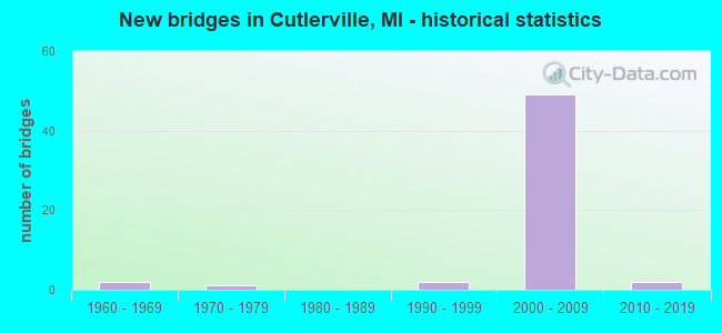
- New bridges - historical statistics
- 21960-1969
- 11970-1979
- 21990-1999
- 492000-2009
- 22010-2019


- Bridge Condition - Deck
- 3.3%Very good
- 83.3%Good
- 13.3%Satisfactory

- Bridge Condition - Superstructure
- 26.7%Very good
- 50.0%Good
- 23.3%Satisfactory

- Bridge Condition - Substructure
- 30.0%Very good
- 56.7%Good
- 13.3%Satisfactory

- Bridge Condition - Channel
- 50.0%Very good
- 12.5%Good
- 37.5%Satisfactory

- Bridge Condition - Culverts
- 40.0%Very good
- 40.0%Good
- 20.0%Satisfactory
Find on map >> Show street view
Structure Number: 505, Location: 11 MI NE OF LANSE (Lat: 46.840611, Lng: -88.251833), Route carried "on" structure: County highway 776, Year Built: 2011, Status: Open, Structure Length: 1.91m (6.27ft), Average Daily Traffic: 944 (year 2014), Truck Traffic: 10%, Average Future Daily Traffic: 1,400 (year 2034), Design Load: Greater than HL93, Features Intersected: RAVINE RIVER, Facility Carried by Structure: SKANEE ROAD
Minimum Vertical Clearance: 30+ m (98+ ft), Kilometerpoint: 19.963, Lanes on structure: 2, Owner: County Highway Agency, Approaching Roadway Width: 11.0m (36.1ft), Material/Design: Concrete, Design/Construction: Culvert, Number Of Spans In Main Unit: 1, Length of Maximum Span: 18.3m (60.0ft), Curb-To-Curb Width: 11.0m (36.1ft), Out-to-Out Width: 13.7m (44.9ft)
Condition: Channel: Very good, Culverts: Very good, Operating Rating: 52.5 metric tons, Method Used To Determine Operating Rating: Load and Resistance Factor (LRFR), Inventory Rating: 36.5 metric tons, Method Used To Determine Inventory Rating: Load and Resistance Factor (LRFR), Structural Evaluation: Equal to present desirable criteria, Deck Geometry: Better than present minimum criteria, Waterway Adequacy: Better than present minimum criteria, Approach Roadway Alignment: Equal to present minimum criteria, Designated Inspection Frequency: Every 24 months, Inspection Date: September 2021, Deck Structure Type: Concrete Cast-file-Place, Wearing Surface/Protective System: Wearing Surface: Bituminous
Find on map >> Show street view
Structure Number: 4939, Location: 1.4 MI S OF WYOMING (Lat: 42.835639, Lng: -85.676442), Route carried "on" structure: US 131, Year Built: 2000, Status: Open, Structure Length: 1.22m (4.00ft), Average Daily Traffic: 61,220 (year 2007), Truck Traffic: 10%, Average Future Daily Traffic: 67,917 (year 2018), Design Load: HS 25 or greater, Features Intersected: BUCK CREEK
Minimum Vertical Clearance: 30.48m (100.00ft), Kilometerpoint: 7.624, Lanes on structure: 6, Base Highway Network: Yes (Inventory Route: 41, Subroute: 3), Owner: State Highway Agency, Approaching Roadway Width: 49.7m (163.1ft), Skew: 13 degrees, Material/Design: Concrete, Design/Construction: Culvert, Number Of Spans In Main Unit: 1, Length of Maximum Span: 12.2m (40.0ft), Curb-To-Curb Width: 54.3m (178.1ft), Out-to-Out Width: 78.2m (256.6ft)
Condition: Channel: Satisfactory, Culverts: Good, Operating Rating: 53.1 metric tons, Method Used To Determine Operating Rating: Load Factor (LF) rating reported by rating factor (RF) method using MS18 loading, Inventory Rating: 34.7 metric tons, Method Used To Determine Inventory Rating: Load Factor (LF) rating reported by rating factor (RF) method using MS18 loading, Structural Evaluation: Better than present minimum criteria, Deck Geometry: Superior to present desirable criteria, Waterway Adequacy: Equal to present desirable criteria, Approach Roadway Alignment: Equal to present desirable criteria, Designated Inspection Frequency: Every 24 months, Inspection Date: September 2020
Find on map >> Show street view
Structure Number: 4944, Location: 6.3 MI S OF GRAND RAPIDS (Lat: 42.832022, Lng: -85.674908), Route carried "on" structure: US 131, Year Built: 2000, Status: Open, Structure Length: 6.89m (22.60ft), Average Daily Traffic: 61,220 (year 2007), Truck Traffic: 10%, Average Future Daily Traffic: 67,917 (year 2018), Design Load: HS 25 or greater, Features Intersected: CONRAIL
Minimum Vertical Clearance: 30.48m (100.00ft), Kilometerpoint: 7.212, Lanes on structure: 8, Base Highway Network: Yes (Inventory Route: 41, Subroute: 3), Owner: State Highway Agency, Approaching Roadway Width: 33.5m (109.9ft), Skew: 34 degrees, Material/Design: Prestressed concrete, Design/Construction: Box Beam or Girders - Multiple, Number Of Spans In Main Unit: 3, Length of Maximum Span: 23.5m (77.1ft), Curb-To-Curb Width: 41.8m (137.1ft), Out-to-Out Width: 43.8m (143.7ft)
Condition: Deck: Satisfactory, Superstructure: Good, Substructure: Good, Operating Rating: 72.9 metric tons, Method Used To Determine Operating Rating: Load Factor (LF) rating reported by rating factor (RF) method using MS18 loading, Inventory Rating: 39.5 metric tons, Method Used To Determine Inventory Rating: Load Factor (LF) rating reported by rating factor (RF) method using MS18 loading, Structural Evaluation: Better than present minimum criteria, Deck Geometry: Superior to present desirable criteria, Approach Roadway Alignment: Better than present minimum criteria, Designated Inspection Frequency: Every 24 months, Inspection Date: September 2020, Deck Structure Type: Concrete Cast-file-Place, Wearing Surface/Protective System: Wearing Surface: Monolithic Concrete, Deck Protection: Epoxy Coated Reinforcing
Find on map >> Show street view
Structure Number: 4963, Location: 2.4 MI S OF WYOMING (Lat: 42.811714, Lng: -85.668733), Route carried "on" structure: County highway 4108, Year Built: 1998, Status: Open, Structure Length: 3.38m (11.09ft), Average Daily Traffic: 12,750 (year 1998), Truck Traffic: 3%, Average Future Daily Traffic: 13,150 (year 2018), Design Load: HS 25 or greater, Features Intersected: US-131, Facility Carried by Structure: 84TH ST
Minimum Vertical Clearance: 30.48m (100.00ft), Kilometerpoint: 9.331, Lanes on structure: 6, Lanes under structure: 4, Owner: State Highway Agency, Approaching Roadway Width: 22.8m (74.8ft), Material/Design: Prestressed concrete, Design/Construction: Box Beam or Girders - Single/Spread, Number Of Spans In Main Unit: 2, Length of Maximum Span: 16.9m (55.4ft), Curb or Sidewalk Widths: Left: 2.4m (7.9ft), Right: 2.4m (7.9ft), Curb-To-Curb Width: 22.8m (74.8ft), Out-to-Out Width: 28.3m (92.8ft)
Condition: Deck: Good, Superstructure: Good, Substructure: Satisfactory, Operating Rating: 67.1 metric tons, Method Used To Determine Operating Rating: Load Factor (LF) rating reported by rating factor (RF) method using MS18 loading, Inventory Rating: 41.1 metric tons, Method Used To Determine Inventory Rating: Load Factor (LF) rating reported by rating factor (RF) method using MS18 loading, Structural Evaluation: Equal to present minimum criteria, Deck Geometry: Meets minimum limits, Underclear: Somewhat better than minimum adequacy, Approach Roadway Alignment: Better than present minimum criteria, Designated Inspection Frequency: Every 24 months, Inspection Date: October 2021, Deck Structure Type: Concrete Cast-file-Place, Wearing Surface/Protective System: Wearing Surface: Epoxy Overlay, Deck Protection: Epoxy Coated Reinforcing
Find on map >> Show street view
Structure Number: 4964, Location: 2.0 MI S OF WYOMING (Lat: 42.826250, Lng: -85.671844), Route carried "on" structure: County highway 2001, Year Built: 2000, Status: Open, Structure Length: 4.13m (13.55ft), Average Daily Traffic: 14,400 (year 2000), Truck Traffic: 15%, Average Future Daily Traffic: 17,700 (year 2020), Design Load: HS 25 or greater, Features Intersected: US-131, Facility Carried by Structure: 76TH ST
Minimum Vertical Clearance: 30.48m (100.00ft), Kilometerpoint: 9.066, Lanes on structure: 6, Lanes under structure: 4, Owner: State Highway Agency, Approaching Roadway Width: 10.3m (33.8ft), Skew: 2 degrees, Material/Design: Prestressed concrete, Design/Construction: Box Beam or Girders - Multiple, Number Of Spans In Main Unit: 2, Length of Maximum Span: 20.6m (67.6ft), Curb or Sidewalk Widths: Left: 2.5m (8.2ft), Right: 2.5m (8.2ft), Curb-To-Curb Width: 21.3m (69.9ft), Out-to-Out Width: 26.9m (88.3ft)
Condition: Deck: Satisfactory, Superstructure: Good, Substructure: Good, Operating Rating: 89.1 metric tons, Method Used To Determine Operating Rating: Load Factor (LF) rating reported by rating factor (RF) method using MS18 loading, Inventory Rating: 53.5 metric tons, Method Used To Determine Inventory Rating: Load Factor (LF) rating reported by rating factor (RF) method using MS18 loading, Structural Evaluation: Better than present minimum criteria, Deck Geometry: High priority of replacement, Underclear: Equal to present minimum criteria, Approach Roadway Alignment: Better than present minimum criteria, Designated Inspection Frequency: Every 24 months, Inspection Date: April 2021, Deck Structure Type: Concrete Cast-file-Place, Wearing Surface/Protective System: Wearing Surface: Monolithic Concrete, Deck Protection: Epoxy Coated Reinforcing
Find on map >> Show street view
Structure Number: 4965, Location: 0.4 MI S OF WYOMING (Lat: 42.840933, Lng: -85.677794), Route carried "on" structure: County highway 2001, Year Built: 2000, Status: Open, Structure Length: 6.29m (20.64ft), Average Daily Traffic: 22,905 (year 1995), Truck Traffic: 10%, Average Future Daily Traffic: 41,369 (year 2015), Design Load: HS 20, Features Intersected: US-131, Facility Carried by Structure: 68TH ST
Minimum Vertical Clearance: 30.48m (100.00ft), Kilometerpoint: 2.068, Lanes on structure: 4, Lanes under structure: 4, Base Highway Network: Yes (Inventory Route: 341, Subroute: 29), Owner: State Highway Agency, Approaching Roadway Width: 10.3m (33.8ft), Material/Design: Prestressed concrete, Design/Construction: Box Beam or Girders - Single/Spread, Number Of Spans In Main Unit: 4, Length of Maximum Span: 17.9m (58.7ft), Curb or Sidewalk Widths: Left: 2.2m (7.2ft), Right: 2.2m (7.2ft), Curb-To-Curb Width: 21.0m (68.9ft), Out-to-Out Width: 23.3m (76.4ft)
Condition: Deck: Good, Superstructure: Satisfactory, Substructure: Good, Operating Rating: 73.9 metric tons, Method Used To Determine Operating Rating: Load Factor (LF) rating reported by rating factor (RF) method using MS18 loading, Inventory Rating: 44.1 metric tons, Method Used To Determine Inventory Rating: Load Factor (LF) rating reported by rating factor (RF) method using MS18 loading, Structural Evaluation: Equal to present minimum criteria, Deck Geometry: Superior to present desirable criteria, Underclear: High priority of corrective action, Approach Roadway Alignment: Better than present minimum criteria, Designated Inspection Frequency: Every 24 months, Inspection Date: May 2021, Deck Structure Type: Concrete Cast-file-Place, Wearing Surface/Protective System: Wearing Surface: Latex Concrete, Deck Protection: Epoxy Coated Reinforcing
Find on map >> Show street view
Structure Number: 5013, Location: 0.45 MI W OF DIVISION AVE (Lat: 42.840850, Lng: -85.672608), Route carried "on" structure: County highway 2001, Year Built: 2002, Status: Open, Structure Length: 1.53m (5.02ft), Average Daily Traffic: 27,000 (year 2004), Truck Traffic: 3%, Average Future Daily Traffic: 45,900 (year 2024), Design Load: HS 20, Features Intersected: BUCK CREEK, Facility Carried by Structure: 68TH STREET
Minimum Vertical Clearance: 30.48m (100.00ft), Kilometerpoint: 2.507, Lanes on structure: 5, Base Highway Network: Yes (Inventory Route: 341, Subroute: 29), Owner: County Highway Agency, Approaching Roadway Width: 18.0m (59.1ft), Material/Design: Prestressed concrete, Design/Construction: Box Beam or Girders - Multiple, Number Of Spans In Main Unit: 1, Length of Maximum Span: 13.5m (44.3ft), Curb or Sidewalk Widths: Left: 2.1m (6.9ft), Right: 2.1m (6.9ft), Curb-To-Curb Width: 22.2m (72.8ft), Out-to-Out Width: 23.1m (75.8ft)
Condition: Deck: Good, Superstructure: Very good, Substructure: Very good, Channel: Very good, Operating Rating: 72.7 metric tons, Method Used To Determine Operating Rating: Load Factor (LF), Inventory Rating: 43.6 metric tons, Method Used To Determine Inventory Rating: Load Factor (LF), Structural Evaluation: Equal to present desirable criteria, Deck Geometry: Equal to present minimum criteria, Waterway Adequacy: Equal to present minimum criteria, Approach Roadway Alignment: Equal to present desirable criteria, Designated Inspection Frequency: Every 24 months, Inspection Date: October 2021, Deck Structure Type: Concrete Cast-file-Place, Wearing Surface/Protective System: Wearing Surface: Monolithic Concrete
Find on map >> Show street view
Structure Number: 5045, Location: 0.25 MILE S OF 76TH ST (Lat: 42.822844, Lng: -85.683442), Route carried "on" structure: County highway , Year Built: 1963, Year Reconstructed: 1974, Status: Open, Structure Length: 0.88m (2.89ft), Average Daily Traffic: 6,431 (year 2003), Average Future Daily Traffic: 10,930 (year 2023), Design Load: HS 20+Mod, Features Intersected: BUCK CREEK, Facility Carried by Structure: CLYDE PARK AVE
Minimum Vertical Clearance: 30.48m (100.00ft), Kilometerpoint: 6.071, Lanes on structure: 4, Owner: County Highway Agency, Approaching Roadway Width: 15.5m (50.9ft), Material/Design: Steel, Design/Construction: Culvert, Number Of Spans In Main Unit: 2, Length of Maximum Span: 4.2m (13.8ft)
Condition: Channel: Satisfactory, Culverts: Good, Operating Rating: 97.2 metric tons, Method Used To Determine Operating Rating: Load Factor (LF) rating reported by rating factor (RF) method using MS18 loading, Inventory Rating: 97.2 metric tons, Method Used To Determine Inventory Rating: Load Factor (LF) rating reported by rating factor (RF) method using MS18 loading, Structural Evaluation: Better than present minimum criteria, Waterway Adequacy: Equal to present desirable criteria, Approach Roadway Alignment: Better than present minimum criteria, Designated Inspection Frequency: Every 24 months, Inspection Date: October 2021
Find on map >> Show street view
Structure Number: 505, Location: 0.3 MI N OF 68TH ST (Lat: 42.845383, Lng: -85.663697), Route carried "on" structure: County highway 2001, Year Built: 1961, Status: Open, Structure Length: 0.64m (2.10ft), Average Daily Traffic: 18,648 (year 2004), Average Future Daily Traffic: 31,700 (year 2024), Design Load: HS 20+Mod, Features Intersected: CUTLERVILLE DRAIN, Facility Carried by Structure: DIVISION AVE
Minimum Vertical Clearance: 30.48m (100.00ft), Kilometerpoint: 9.486, Lanes on structure: 2, Owner: County Highway Agency, Approaching Roadway Width: 14.0m (45.9ft), Material/Design: Concrete, Design/Construction: Culvert, Number Of Spans In Main Unit: 2, Length of Maximum Span: 2.7m (8.9ft)
Condition: Channel: Very good, Culverts: Satisfactory, Operating Rating: 42.1 metric tons, Method Used To Determine Operating Rating: Load Factor (LF) rating reported by rating factor (RF) method using MS18 loading, Inventory Rating: 32.4 metric tons, Method Used To Determine Inventory Rating: Load Factor (LF) rating reported by rating factor (RF) method using MS18 loading, Structural Evaluation: Equal to present minimum criteria, Waterway Adequacy: Equal to present desirable criteria, Approach Roadway Alignment: Equal to present desirable criteria, Designated Inspection Frequency: Every 24 months, Inspection Date: October 2021
Find on map >> Show street view
Structure Number: 5139, Location: 0.25 MI E OF DIVISION AVE (Lat: 42.820761, Lng: -85.658575), Route carried "on" structure: County highway , Year Built: 1976, Status: Open, Structure Length: 0.67m (2.20ft), Average Daily Traffic: 704 (year 2003), Average Future Daily Traffic: 1,200 (year 2023), Design Load: HS 20+Mod, Features Intersected: SHARPS CREEK, Facility Carried by Structure: 79TH STREET
Minimum Vertical Clearance: 30.48m (100.00ft), Kilometerpoint: 0.410, Lanes on structure: 2, Owner: County Highway Agency, Approaching Roadway Width: 6.7m (22.0ft), Material/Design: Steel, Design/Construction: Culvert, Number Of Spans In Main Unit: 2, Length of Maximum Span: 2.7m (8.9ft)
Condition: Channel: Good, Culverts: Very good, Operating Rating: 41.1 metric tons, Method Used To Determine Operating Rating: Load Factor (LF) rating reported by rating factor (RF) method using MS18 loading, Inventory Rating: 34.0 metric tons, Method Used To Determine Inventory Rating: Load Factor (LF) rating reported by rating factor (RF) method using MS18 loading, Structural Evaluation: Equal to present desirable criteria, Waterway Adequacy: Equal to present desirable criteria, Approach Roadway Alignment: Equal to present minimum criteria, Designated Inspection Frequency: Every 24 months, Inspection Date: November 2021
Find on map >> Show street view
Structure Number: 12893, Location: BYRON TWP SEC 1 (Lat: 42.848533, Lng: -85.668600), Route carried "on" structure: State highway 6, Year Built: 2001, Status: Open, Structure Length: 15.60m (51.18ft), Average Daily Traffic: 26,271 (year 2007), Truck Traffic: 5%, Average Future Daily Traffic: 47,355 (year 2018), Design Load: HS 25 or greater, Features Intersected: BUCK CREEK
Minimum Vertical Clearance: 30.48m (100.00ft), Kilometerpoint: 9.494, Lanes on structure: 3, Base Highway Network: Yes (Inventory Route: 200, Subroute: 1), Owner: State Highway Agency, Approaching Roadway Width: 19.8m (65.0ft), Material/Design: Prestressed concrete, Design/Construction: Stringer/Multi-beam, Number Of Spans In Main Unit: 4, Length of Maximum Span: 44.7m (146.7ft), Curb-To-Curb Width: 19.8m (65.0ft), Out-to-Out Width: 22.1m (72.5ft)
Condition: Deck: Good, Superstructure: Good, Substructure: Very good, Channel: Very good, Operating Rating: 61.6 metric tons, Method Used To Determine Operating Rating: Load Factor (LF) rating reported by rating factor (RF) method using MS18 loading, Inventory Rating: 27.5 metric tons, Method Used To Determine Inventory Rating: Load Factor (LF) rating reported by rating factor (RF) method using MS18 loading, Structural Evaluation: Equal to present minimum criteria, Deck Geometry: Superior to present desirable criteria, Waterway Adequacy: Superior to present desirable criteria, Approach Roadway Alignment: Equal to present desirable criteria, Designated Inspection Frequency: Every 24 months, Inspection Date: September 2020, Deck Structure Type: Concrete Cast-file-Place, Wearing Surface/Protective System: Wearing Surface: Monolithic Concrete, Deck Protection: Epoxy Coated Reinforcing
Find on map >> Show street view
Structure Number: 129, Location: BYRON TWP SEC 1 (Lat: 42.848953, Lng: -85.668667), Route carried "on" structure: State highway 6, Year Built: 2000, Status: Open, Structure Length: 15.60m (51.18ft), Average Daily Traffic: 26,271 (year 2007), Truck Traffic: 3%, Average Future Daily Traffic: 49,200 (year 2020), Design Load: HS 25 or greater, Features Intersected: BUCK CREEK
Minimum Vertical Clearance: 30.48m (100.00ft), Kilometerpoint: 9.487, Lanes on structure: 3, Base Highway Network: Yes (Inventory Route: 200, Subroute: 2), Owner: State Highway Agency, Approaching Roadway Width: 19.8m (65.0ft), Material/Design: Prestressed concrete, Design/Construction: Stringer/Multi-beam, Number Of Spans In Main Unit: 4, Length of Maximum Span: 44.7m (146.7ft), Curb-To-Curb Width: 19.8m (65.0ft), Out-to-Out Width: 20.8m (68.2ft)
Condition: Deck: Good, Superstructure: Very good, Substructure: Very good, Channel: Satisfactory, Operating Rating: 71.9 metric tons, Method Used To Determine Operating Rating: Load Factor (LF) rating reported by rating factor (RF) method using MS18 loading, Inventory Rating: 43.1 metric tons, Method Used To Determine Inventory Rating: Load Factor (LF) rating reported by rating factor (RF) method using MS18 loading, Structural Evaluation: Equal to present desirable criteria, Deck Geometry: Superior to present desirable criteria, Waterway Adequacy: Equal to present desirable criteria, Approach Roadway Alignment: Equal to present desirable criteria, Designated Inspection Frequency: Every 24 months, Inspection Date: September 2020, Deck Structure Type: Concrete Cast-file-Place, Wearing Surface/Protective System: Wearing Surface: Monolithic Concrete, Deck Protection: Epoxy Coated Reinforcing
Find on map >> Show street view
Structure Number: 12904, Location: BYRON TWP SEC 1 (Lat: 42.848939, Lng: -85.673767), Route carried "on" structure: State highway 6, Year Built: 2000, Status: Open, Structure Length: 2.20m (7.22ft), Average Daily Traffic: 26,271 (year 2007), Truck Traffic: 3%, Average Future Daily Traffic: 20,200 (year 2025), Design Load: HS 20, Features Intersected: NORFOLK SOUTHERN RR
Minimum Vertical Clearance: 30.48m (100.00ft), Kilometerpoint: 9.072, Lanes on structure: 2, Base Highway Network: Yes (Inventory Route: 200, Subroute: 2), Owner: State Highway Agency, Approaching Roadway Width: 12.8m (42.0ft), Material/Design: Prestressed concrete, Design/Construction: Stringer/Multi-beam, Number Of Spans In Main Unit: 1, Length of Maximum Span: 22.0m (72.2ft), Curb-To-Curb Width: 13.1m (43.0ft), Out-to-Out Width: 14.2m (46.6ft)
Condition: Deck: Good, Superstructure: Good, Substructure: Good, Operating Rating: 71.9 metric tons, Method Used To Determine Operating Rating: Load Factor (LF) rating reported by rating factor (RF) method using MS18 loading, Inventory Rating: 43.1 metric tons, Method Used To Determine Inventory Rating: Load Factor (LF) rating reported by rating factor (RF) method using MS18 loading, Structural Evaluation: Better than present minimum criteria, Deck Geometry: Superior to present desirable criteria, Underclear: Equal to present desirable criteria, Approach Roadway Alignment: Equal to present desirable criteria, Designated Inspection Frequency: Every 24 months, Inspection Date: September 2020, Deck Structure Type: Concrete Cast-file-Place, Wearing Surface/Protective System: Wearing Surface: Monolithic Concrete, Deck Protection: Epoxy Coated Reinforcing
Find on map >> Show street view
Structure Number: 12905, Location: BYRON TWP SEC 1 (Lat: 42.848658, Lng: -85.673758), Route carried "on" structure: State highway 6, Year Built: 2000, Status: Open, Structure Length: 2.20m (7.22ft), Average Daily Traffic: 26,271 (year 2007), Truck Traffic: 3%, Average Future Daily Traffic: 24,900 (year 2025), Design Load: HS 20, Features Intersected: NORFOLK SOUTHERN RR
Minimum Vertical Clearance: 30.48m (100.00ft), Kilometerpoint: 9.072, Lanes on structure: 2, Base Highway Network: Yes (Inventory Route: 200, Subroute: 1), Owner: State Highway Agency, Approaching Roadway Width: 13.1m (43.0ft), Material/Design: Prestressed concrete, Design/Construction: Stringer/Multi-beam, Number Of Spans In Main Unit: 1, Length of Maximum Span: 22.0m (72.2ft), Curb-To-Curb Width: 13.1m (43.0ft), Out-to-Out Width: 14.2m (46.6ft)
Condition: Deck: Good, Superstructure: Very good, Substructure: Good, Operating Rating: 73.6 metric tons, Method Used To Determine Operating Rating: Load Factor (LF), Inventory Rating: 40.7 metric tons, Method Used To Determine Inventory Rating: Load Factor (LF), Structural Evaluation: Better than present minimum criteria, Deck Geometry: Superior to present desirable criteria, Underclear: Equal to present desirable criteria, Approach Roadway Alignment: Equal to present desirable criteria, Designated Inspection Frequency: Every 24 months, Inspection Date: September 2020, Deck Structure Type: Concrete Cast-file-Place, Wearing Surface/Protective System: Wearing Surface: Monolithic Concrete, Deck Protection: Epoxy Coated Reinforcing
Find on map >> Show street view
Structure Number: 12907, Location: BYRON TWP SEC 1 (Lat: 42.849608, Lng: -85.673778), Route carried "on" structure: Ramp State highway 6, Year Built: 2000, Status: Open, Structure Length: 2.20m (7.22ft), Average Daily Traffic: 9,700 (year 2000), Truck Traffic: 6%, Average Future Daily Traffic: 9,700 (year 2015), Design Load: HS 25 or greater, Features Intersected: NORFOLK SOUTHERN RR
Minimum Vertical Clearance: 30.48m (100.00ft), Kilometerpoint: 0.346, Lanes on structure: 1, Owner: State Highway Agency, Approaching Roadway Width: 8.2m (26.9ft), Skew: 2 degrees, Material/Design: Prestressed concrete, Design/Construction: Stringer/Multi-beam, Number Of Spans In Main Unit: 1, Length of Maximum Span: 22.0m (72.2ft), Curb-To-Curb Width: 9.4m (30.8ft), Out-to-Out Width: 10.4m (34.1ft)
Condition: Deck: Good, Superstructure: Good, Substructure: Satisfactory, Operating Rating: 69.2 metric tons, Method Used To Determine Operating Rating: Load Factor (LF), Inventory Rating: 47.1 metric tons, Method Used To Determine Inventory Rating: Load Factor (LF), Structural Evaluation: Equal to present minimum criteria, Deck Geometry: Superior to present desirable criteria, Underclear: Equal to present desirable criteria, Approach Roadway Alignment: Equal to present desirable criteria, Designated Inspection Frequency: Every 24 months, Inspection Date: September 2020, Deck Structure Type: Concrete Cast-file-Place, Wearing Surface/Protective System: Wearing Surface: Monolithic Concrete, Deck Protection: Epoxy Coated Reinforcing
Find on map >> Show street view
Structure Number: 12908, Location: BYRON TWP SEC 1 (Lat: 42.849192, Lng: -85.673772), Route carried "on" structure: Ramp State highway 6, Year Built: 2000, Status: Open, Structure Length: 2.20m (7.22ft), Average Daily Traffic: 15,300 (year 2000), Truck Traffic: 6%, Average Future Daily Traffic: 15,300 (year 2015), Design Load: HS 25 or greater, Features Intersected: NORFOLK SOUTHERN RR
Minimum Vertical Clearance: 30.48m (100.00ft), Kilometerpoint: 1.448, Lanes on structure: 1, Owner: State Highway Agency, Approaching Roadway Width: 8.8m (28.9ft), Material/Design: Prestressed concrete, Design/Construction: Stringer/Multi-beam, Number Of Spans In Main Unit: 1, Length of Maximum Span: 22.0m (72.2ft), Curb-To-Curb Width: 9.4m (30.8ft), Out-to-Out Width: 10.3m (33.8ft)
Condition: Deck: Good, Superstructure: Very good, Substructure: Good, Operating Rating: 75.5 metric tons, Method Used To Determine Operating Rating: Load Factor (LF) rating reported by rating factor (RF) method using MS18 loading, Inventory Rating: 45.0 metric tons, Method Used To Determine Inventory Rating: Load Factor (LF) rating reported by rating factor (RF) method using MS18 loading, Structural Evaluation: Better than present minimum criteria, Deck Geometry: Superior to present desirable criteria, Underclear: Equal to present desirable criteria, Approach Roadway Alignment: Equal to present desirable criteria, Designated Inspection Frequency: Every 24 months, Inspection Date: September 2020, Deck Structure Type: Concrete Cast-file-Place, Wearing Surface/Protective System: Wearing Surface: Monolithic Concrete, Deck Protection: Epoxy Coated Reinforcing
Find on map >> Show street view
Structure Number: 1291, Location: BYRON TWP SEC 1 (Lat: 42.848392, Lng: -85.673753), Route carried "on" structure: Ramp State highway 6, Year Built: 2000, Status: Open, Structure Length: 2.20m (7.22ft), Average Daily Traffic: 15,300 (year 2000), Truck Traffic: 6%, Average Future Daily Traffic: 15,300 (year 2015), Design Load: HS 25 or greater, Features Intersected: NORFOLK SOUTHERN RR
Minimum Vertical Clearance: 30.48m (100.00ft), Kilometerpoint: 1.334, Lanes on structure: 1, Owner: State Highway Agency, Approaching Roadway Width: 8.8m (28.9ft), Material/Design: Prestressed concrete, Design/Construction: Stringer/Multi-beam, Number Of Spans In Main Unit: 1, Length of Maximum Span: 22.0m (72.2ft), Curb-To-Curb Width: 9.4m (30.8ft), Out-to-Out Width: 10.3m (33.8ft)
Condition: Deck: Good, Superstructure: Very good, Substructure: Good, Operating Rating: 84.6 metric tons, Method Used To Determine Operating Rating: Load Factor (LF) rating reported by rating factor (RF) method using MS18 loading, Inventory Rating: 50.5 metric tons, Method Used To Determine Inventory Rating: Load Factor (LF) rating reported by rating factor (RF) method using MS18 loading, Structural Evaluation: Better than present minimum criteria, Deck Geometry: Superior to present desirable criteria, Approach Roadway Alignment: Equal to present desirable criteria, Designated Inspection Frequency: Every 24 months, Inspection Date: September 2021, Deck Structure Type: Concrete Cast-file-Place, Wearing Surface/Protective System: Wearing Surface: Monolithic Concrete, Deck Protection: Epoxy Coated Reinforcing
Find on map >> Show street view
Structure Number: 12911, Location: BYRON TWP SEC 1 (Lat: 42.848069, Lng: -85.673747), Route carried "on" structure: Ramp State highway 6, Year Built: 2000, Status: Open, Structure Length: 2.33m (7.64ft), Average Daily Traffic: 5,600 (year 2000), Average Future Daily Traffic: 5,600 (year 2015), Design Load: HS 25 or greater, Features Intersected: NORFOLK SOUTHERN RR
Minimum Vertical Clearance: 30.48m (100.00ft), Kilometerpoint: 0.597, Lanes on structure: 1, Owner: State Highway Agency, Approaching Roadway Width: 8.2m (26.9ft), Skew: 2 degrees, Material/Design: Prestressed concrete, Design/Construction: Stringer/Multi-beam, Number Of Spans In Main Unit: 1, Length of Maximum Span: 23.3m (76.4ft), Curb-To-Curb Width: 9.8m (32.2ft), Out-to-Out Width: 11.9m (39.0ft)
Condition: Deck: Good, Superstructure: Very good, Substructure: Satisfactory, Operating Rating: 68.7 metric tons, Method Used To Determine Operating Rating: Load Factor (LF) rating reported by rating factor (RF) method using MS18 loading, Inventory Rating: 41.1 metric tons, Method Used To Determine Inventory Rating: Load Factor (LF) rating reported by rating factor (RF) method using MS18 loading, Structural Evaluation: Equal to present minimum criteria, Deck Geometry: Superior to present desirable criteria, Underclear: Equal to present desirable criteria, Approach Roadway Alignment: Equal to present desirable criteria, Designated Inspection Frequency: Every 24 months, Inspection Date: September 2021, Deck Structure Type: Concrete Cast-file-Place, Wearing Surface/Protective System: Wearing Surface: Monolithic Concrete, Deck Protection: Epoxy Coated Reinforcing
Find on map >> Show street view
Structure Number: 12913, Location: BYRON TWP SEC 2&3 (Lat: 42.852656, Lng: -85.703311), Route carried "on" structure: County highway , Year Built: 2001, Status: Open, Structure Length: 8.76m (28.74ft), Average Daily Traffic: 5,200 (year 2000), Truck Traffic: 5%, Average Future Daily Traffic: 6,700 (year 2015), Design Load: HS 20, Features Intersected: M-6, Facility Carried by Structure: BURLINGAME AVE
Minimum Vertical Clearance: 30.48m (100.00ft), Kilometerpoint: 9.343, Lanes on structure: 2, Lanes under structure: 6, Owner: State Highway Agency, Approaching Roadway Width: 14.2m (46.6ft), Skew: 1 degrees, Material/Design: Prestressed concrete, Design/Construction: Stringer/Multi-beam, Number Of Spans In Main Unit: 2, Length of Maximum Span: 44.8m (147.0ft), Curb-To-Curb Width: 13.2m (43.3ft), Out-to-Out Width: 14.2m (46.6ft)
Condition: Deck: Good, Superstructure: Very good, Substructure: Very good, Operating Rating: 53.1 metric tons, Method Used To Determine Operating Rating: Load and Resistance Factor Rating (LRFR) rating reported by rating factor(RF) method using HL-93 loadings, Inventory Rating: 41.1 metric tons, Method Used To Determine Inventory Rating: Load and Resistance Factor Rating (LRFR) rating reported by rating factor(RF) method using HL-93 loadings, Structural Evaluation: Equal to present desirable criteria, Deck Geometry: Somewhat better than minimum adequacy, Underclear: Somewhat better than minimum adequacy, Approach Roadway Alignment: Equal to present desirable criteria, Designated Inspection Frequency: Every 24 months, Inspection Date: May 2021, Deck Structure Type: Concrete Cast-file-Place, Wearing Surface/Protective System: Wearing Surface: Monolithic Concrete, Deck Protection: Epoxy Coated Reinforcing
Find on map >> Show street view
Structure Number: 12914, Location: BYRON TWP SEC 1&2 (Lat: 42.848378, Lng: -85.683578), Route carried "on" structure: Ramp State highway 6, Year Built: 2000, Status: Open, Structure Length: 3.90m (12.80ft), Average Daily Traffic: 8,500 (year 2000), Truck Traffic: 9%, Average Future Daily Traffic: 8,500 (year 2015), Design Load: HS 25 or greater, Features Intersected: CLYDE PARK AVENUE
Minimum Vertical Clearance: 30.48m (100.00ft), Kilometerpoint: 0.533, Lanes on structure: 1, Lanes under structure: 4, Owner: State Highway Agency, Approaching Roadway Width: 7.9m (25.9ft), Material/Design: Prestressed concrete, Design/Construction: Stringer/Multi-beam, Number Of Spans In Main Unit: 1, Length of Maximum Span: 39.0m (128.0ft), Curb-To-Curb Width: 9.3m (30.5ft), Out-to-Out Width: 10.4m (34.1ft)
Condition: Deck: Good, Superstructure: Good, Substructure: Very good, Operating Rating: 78.4 metric tons, Method Used To Determine Operating Rating: Load Factor (LF) rating reported by rating factor (RF) method using MS18 loading, Inventory Rating: 47.0 metric tons, Method Used To Determine Inventory Rating: Load Factor (LF) rating reported by rating factor (RF) method using MS18 loading, Structural Evaluation: Better than present minimum criteria, Deck Geometry: Superior to present desirable criteria, Underclear: Meets minimum limits, Approach Roadway Alignment: Equal to present desirable criteria, Designated Inspection Frequency: Every 24 months, Inspection Date: August 2020, Deck Structure Type: Concrete Cast-file-Place, Wearing Surface/Protective System: Wearing Surface: Monolithic Concrete, Deck Protection: Epoxy Coated Reinforcing
Find on map >> Show street view
Structure Number: 12915, Location: BYRON TWP SEC 1&2 (Lat: 42.848633, Lng: -85.683583), Route carried "on" structure: State highway 6, Year Built: 2000, Status: Open, Structure Length: 3.90m (12.80ft), Average Daily Traffic: 25,815 (year 2007), Truck Traffic: 9%, Average Future Daily Traffic: 23,750 (year 2015), Design Load: HS 25 or greater, Features Intersected: CLYDE PARK AVENUE
Minimum Vertical Clearance: 30.48m (100.00ft), Kilometerpoint: 8.271, Lanes on structure: 2, Lanes under structure: 4, Base Highway Network: Yes (Inventory Route: 200, Subroute: 1), Owner: State Highway Agency, Approaching Roadway Width: 11.2m (36.7ft), Material/Design: Prestressed concrete, Design/Construction: Stringer/Multi-beam, Number Of Spans In Main Unit: 1, Length of Maximum Span: 39.0m (128.0ft), Curb-To-Curb Width: 13.2m (43.3ft), Out-to-Out Width: 14.2m (46.6ft)
Condition: Deck: Good, Superstructure: Very good, Substructure: Very good, Operating Rating: 72.3 metric tons, Method Used To Determine Operating Rating: Load Factor (LF) rating reported by rating factor (RF) method using MS18 loading, Inventory Rating: 43.4 metric tons, Method Used To Determine Inventory Rating: Load Factor (LF) rating reported by rating factor (RF) method using MS18 loading, Structural Evaluation: Equal to present desirable criteria, Deck Geometry: Superior to present desirable criteria, Underclear: Meets minimum limits, Approach Roadway Alignment: Equal to present desirable criteria, Designated Inspection Frequency: Every 24 months, Inspection Date: August 2020, Deck Structure Type: Concrete Cast-file-Place, Wearing Surface/Protective System: Wearing Surface: Monolithic Concrete, Deck Protection: Epoxy Coated Reinforcing
Find on map >> Show street view
Structure Number: 12916, Location: BYRON TWP SEC 1&2 (Lat: 42.848914, Lng: -85.683583), Route carried "on" structure: State highway 6, Year Built: 2000, Status: Open, Structure Length: 3.90m (12.80ft), Average Daily Traffic: 25,815 (year 2007), Truck Traffic: 10%, Average Future Daily Traffic: 24,250 (year 2015), Design Load: HS 25 or greater, Features Intersected: CLYDE PARK AVENUE
Minimum Vertical Clearance: 30.48m (100.00ft), Kilometerpoint: 8.269, Lanes on structure: 2, Lanes under structure: 4, Base Highway Network: Yes (Inventory Route: 200, Subroute: 2), Owner: State Highway Agency, Approaching Roadway Width: 11.2m (36.7ft), Material/Design: Prestressed concrete, Design/Construction: Stringer/Multi-beam, Number Of Spans In Main Unit: 1, Length of Maximum Span: 39.0m (128.0ft), Curb-To-Curb Width: 13.2m (43.3ft), Out-to-Out Width: 14.2m (46.6ft)
Condition: Deck: Good, Superstructure: Good, Substructure: Good, Operating Rating: 83.3 metric tons, Method Used To Determine Operating Rating: Load Factor (LF) rating reported by rating factor (RF) method using MS18 loading, Inventory Rating: 49.9 metric tons, Method Used To Determine Inventory Rating: Load Factor (LF) rating reported by rating factor (RF) method using MS18 loading, Structural Evaluation: Better than present minimum criteria, Deck Geometry: Superior to present desirable criteria, Underclear: High priority of corrective action, Approach Roadway Alignment: Equal to present desirable criteria, Designated Inspection Frequency: Every 24 months, Inspection Date: August 2020, Deck Structure Type: Concrete Cast-file-Place, Wearing Surface/Protective System: Wearing Surface: Monolithic Concrete, Deck Protection: Epoxy Coated Reinforcing
Find on map >> Show street view
Structure Number: 12917, Location: BYRON TWP SEC 1&2 (Lat: 42.849189, Lng: -85.683583), Route carried "on" structure: Ramp State highway 6, Year Built: 2000, Status: Open, Structure Length: 3.90m (12.80ft), Average Daily Traffic: 8,250 (year 2000), Truck Traffic: 8%, Average Future Daily Traffic: 8,250 (year 2015), Design Load: HS 25 or greater, Features Intersected: CLYDE PARK AVENUE
Minimum Vertical Clearance: 30.48m (100.00ft), Kilometerpoint: 0.647, Lanes on structure: 1, Lanes under structure: 4, Owner: State Highway Agency, Approaching Roadway Width: 8.5m (27.9ft), Material/Design: Prestressed concrete, Design/Construction: Stringer/Multi-beam, Number Of Spans In Main Unit: 1, Length of Maximum Span: 39.0m (128.0ft), Curb-To-Curb Width: 9.3m (30.5ft), Out-to-Out Width: 10.4m (34.1ft)
Condition: Deck: Good, Superstructure: Satisfactory, Substructure: Very good, Operating Rating: 81.0 metric tons, Method Used To Determine Operating Rating: Load Factor (LF) rating reported by rating factor (RF) method using MS18 loading, Inventory Rating: 48.6 metric tons, Method Used To Determine Inventory Rating: Load Factor (LF) rating reported by rating factor (RF) method using MS18 loading, Structural Evaluation: Equal to present minimum criteria, Deck Geometry: Superior to present desirable criteria, Underclear: Meets minimum limits, Approach Roadway Alignment: Equal to present desirable criteria, Designated Inspection Frequency: Every 24 months, Inspection Date: August 2020, Deck Structure Type: Concrete Cast-file-Place, Wearing Surface/Protective System: Wearing Surface: Monolithic Concrete, Deck Protection: Epoxy Coated Reinforcing
Find on map >> Show street view
Structure Number: 12918, Location: BYRON TWP SEC 1 (Lat: 42.843103, Lng: -85.677683), Route carried "on" structure: Ramp State highway 6, Year Built: 2000, Status: Open, Structure Length: 5.51m (18.08ft), Average Daily Traffic: 8,250 (year 2000), Truck Traffic: 8%, Average Future Daily Traffic: 8,250 (year 2015), Design Load: HS 25 or greater, Features Intersected: US-131NB C-D & RAMP B
Minimum Vertical Clearance: 30.48m (100.00ft), Kilometerpoint: 0.243, Lanes on structure: 2, Lanes under structure: 2, Owner: State Highway Agency, Approaching Roadway Width: 10.9m (35.8ft), Skew: 7 degrees, Material/Design: Steel, Design/Construction: Stringer/Multi-beam, Number Of Spans In Main Unit: 1, Length of Maximum Span: 55.1m (180.8ft), Curb-To-Curb Width: 12.2m (40.0ft), Out-to-Out Width: 13.2m (43.3ft)
Condition: Deck: Good, Superstructure: Satisfactory, Substructure: Good, Operating Rating: 75.0 metric tons, Method Used To Determine Operating Rating: Load Factor (LF), Inventory Rating: 45.0 metric tons, Method Used To Determine Inventory Rating: Load Factor (LF), Structural Evaluation: Equal to present minimum criteria, Deck Geometry: Superior to present desirable criteria, Underclear: Better than present minimum criteria, Approach Roadway Alignment: Equal to present desirable criteria, Designated Inspection Frequency: Every 24 months, Inspection Date: September 2021, Deck Structure Type: Concrete Cast-file-Place, Wearing Surface/Protective System: Wearing Surface: Monolithic Concrete, Deck Protection: Epoxy Coated Reinforcing
Find on map >> Show street view
Structure Number: 12919, Location: BYRON TWP SEC 1&2 (Lat: 42.843942, Lng: -85.679233), Route carried "on" structure: Ramp State highway 6, Year Built: 2000, Status: Open, Structure Length: 5.73m (18.80ft), Average Daily Traffic: 9,250 (year 2000), Truck Traffic: 8%, Average Future Daily Traffic: 9,250 (year 2015), Design Load: HS 25 or greater, Features Intersected: US-131SB C-D & RAMP C
Minimum Vertical Clearance: 30.48m (100.00ft), Kilometerpoint: 0.388, Lanes on structure: 1, Lanes under structure: 2, Owner: State Highway Agency, Approaching Roadway Width: 9.3m (30.5ft), Skew: 7 degrees, Material/Design: Steel, Design/Construction: Stringer/Multi-beam, Number Of Spans In Main Unit: 1, Length of Maximum Span: 57.3m (188.0ft), Curb-To-Curb Width: 9.3m (30.5ft), Out-to-Out Width: 10.3m (33.8ft)
Condition: Deck: Satisfactory, Superstructure: Satisfactory, Substructure: Satisfactory, Operating Rating: 69.9 metric tons, Method Used To Determine Operating Rating: Load Factor (LF), Inventory Rating: 41.8 metric tons, Method Used To Determine Inventory Rating: Load Factor (LF), Structural Evaluation: Equal to present minimum criteria, Deck Geometry: Superior to present desirable criteria, Underclear: High priority of corrective action, Approach Roadway Alignment: Equal to present desirable criteria, Designated Inspection Frequency: Every 24 months, Inspection Date: September 2021, Deck Structure Type: Concrete Cast-file-Place, Wearing Surface/Protective System: Wearing Surface: Monolithic Concrete, Deck Protection: Epoxy Coated Reinforcing
Find on map >> Show street view
Structure Number: 1292, Location: BYRON TWP SEC 1 (Lat: 42.848394, Lng: -85.678053), Route carried "on" structure: Ramp State highway 6, Year Built: 2000, Status: Open, Structure Length: 11.69m (38.35ft), Average Daily Traffic: 15,250 (year 2000), Truck Traffic: 8%, Average Future Daily Traffic: 15,250 (year 2015), Design Load: HS 25 or greater, Features Intersected: US-131
Minimum Vertical Clearance: 30.48m (100.00ft), Kilometerpoint: 0.950, Lanes on structure: 2, Lanes under structure: 13, Owner: State Highway Agency, Approaching Roadway Width: 11.7m (38.4ft), Material/Design: Prestressed concrete, Design/Construction: Stringer/Multi-beam, Number Of Spans In Main Unit: 4, Length of Maximum Span: 35.1m (115.2ft), Curb-To-Curb Width: 13.1m (43.0ft), Out-to-Out Width: 14.1m (46.3ft)
Condition: Deck: Good, Superstructure: Good, Substructure: Good, Operating Rating: 57.0 metric tons, Method Used To Determine Operating Rating: Load Factor (LF) rating reported by rating factor (RF) method using MS18 loading, Inventory Rating: 36.0 metric tons, Method Used To Determine Inventory Rating: Load Factor (LF) rating reported by rating factor (RF) method using MS18 loading, Structural Evaluation: Better than present minimum criteria, Deck Geometry: Superior to present desirable criteria, Underclear: Somewhat better than minimum adequacy, Approach Roadway Alignment: Equal to present desirable criteria, Designated Inspection Frequency: Every 24 months, Inspection Date: September 2020, Deck Structure Type: Concrete Cast-file-Place, Wearing Surface/Protective System: Wearing Surface: Monolithic Concrete, Deck Protection: Epoxy Coated Reinforcing
Find on map >> Show street view
Structure Number: 12921, Location: BYRON TWP SEC 1 (Lat: 42.849183, Lng: -85.678094), Route carried "on" structure: Ramp State highway 6, Year Built: 2000, Status: Open, Structure Length: 11.69m (38.35ft), Average Daily Traffic: 13,750 (year 2000), Truck Traffic: 7%, Average Future Daily Traffic: 15,813 (year 2020), Design Load: HS 25 or greater, Features Intersected: US-131
Minimum Vertical Clearance: 30.48m (100.00ft), Kilometerpoint: 1.062, Lanes on structure: 2, Lanes under structure: 13, Owner: State Highway Agency, Approaching Roadway Width: 11.7m (38.4ft), Material/Design: Prestressed concrete, Design/Construction: Stringer/Multi-beam, Number Of Spans In Main Unit: 4, Length of Maximum Span: 35.1m (115.2ft), Curb-To-Curb Width: 13.1m (43.0ft), Out-to-Out Width: 14.1m (46.3ft)
Condition: Deck: Good, Superstructure: Good, Substructure: Good, Operating Rating: 57.0 metric tons, Method Used To Determine Operating Rating: Load Factor (LF) rating reported by rating factor (RF) method using MS18 loading, Inventory Rating: 36.0 metric tons, Method Used To Determine Inventory Rating: Load Factor (LF) rating reported by rating factor (RF) method using MS18 loading, Structural Evaluation: Better than present minimum criteria, Deck Geometry: Superior to present desirable criteria, Underclear: Somewhat better than minimum adequacy, Approach Roadway Alignment: Equal to present desirable criteria, Designated Inspection Frequency: Every 24 months, Inspection Date: September 2021, Deck Structure Type: Concrete Cast-file-Place, Wearing Surface/Protective System: Wearing Surface: Monolithic Concrete, Deck Protection: Epoxy Coated Reinforcing
Find on map >> Show street view
Structure Number: 12922, Location: BYRON TWP SEC 1 (Lat: 42.848928, Lng: -85.678081), Route carried "on" structure: State highway 6, Year Built: 2000, Status: Open, Structure Length: 11.69m (38.35ft), Average Daily Traffic: 26,271 (year 2007), Truck Traffic: 10%, Average Future Daily Traffic: 24,250 (year 2015), Design Load: HS 25 or greater, Features Intersected: US-131
Minimum Vertical Clearance: 30.48m (100.00ft), Kilometerpoint: 8.686, Lanes on structure: 2, Lanes under structure: 13, Base Highway Network: Yes (Inventory Route: 200, Subroute: 2), Owner: State Highway Agency, Approaching Roadway Width: 12.4m (40.7ft), Material/Design: Prestressed concrete, Design/Construction: Stringer/Multi-beam, Number Of Spans In Main Unit: 4, Length of Maximum Span: 35.1m (115.2ft), Curb-To-Curb Width: 13.2m (43.3ft), Out-to-Out Width: 14.2m (46.6ft)
Condition: Deck: Good, Superstructure: Good, Substructure: Good, Operating Rating: 57.0 metric tons, Method Used To Determine Operating Rating: Load Factor (LF) rating reported by rating factor (RF) method using MS18 loading, Inventory Rating: 36.0 metric tons, Method Used To Determine Inventory Rating: Load Factor (LF) rating reported by rating factor (RF) method using MS18 loading, Structural Evaluation: Better than present minimum criteria, Deck Geometry: Superior to present desirable criteria, Underclear: Equal to present minimum criteria, Approach Roadway Alignment: Equal to present desirable criteria, Designated Inspection Frequency: Every 24 months, Inspection Date: September 2021, Deck Structure Type: Concrete Cast-file-Place, Wearing Surface/Protective System: Wearing Surface: Monolithic Concrete, Deck Protection: Epoxy Coated Reinforcing
Find on map >> Show street view
Structure Number: 12923, Location: BYRON TWP SEC 1 (Lat: 42.848644, Lng: -85.678067), Route carried "on" structure: State highway 6, Year Built: 2000, Status: Open, Structure Length: 11.69m (38.35ft), Average Daily Traffic: 26,271 (year 2007), Truck Traffic: 10%, Average Future Daily Traffic: 23,750 (year 2015), Design Load: HS 25 or greater, Features Intersected: US-131
Minimum Vertical Clearance: 30.48m (100.00ft), Kilometerpoint: 8.688, Lanes on structure: 2, Lanes under structure: 13, Base Highway Network: Yes (Inventory Route: 200, Subroute: 1), Owner: State Highway Agency, Approaching Roadway Width: 12.4m (40.7ft), Material/Design: Prestressed concrete, Design/Construction: Stringer/Multi-beam, Number Of Spans In Main Unit: 4, Length of Maximum Span: 35.1m (115.2ft), Curb-To-Curb Width: 13.2m (43.3ft), Out-to-Out Width: 14.2m (46.6ft)
Condition: Deck: Good, Superstructure: Good, Substructure: Good, Operating Rating: 57.0 metric tons, Method Used To Determine Operating Rating: Load Factor (LF) rating reported by rating factor (RF) method using MS18 loading, Inventory Rating: 36.0 metric tons, Method Used To Determine Inventory Rating: Load Factor (LF) rating reported by rating factor (RF) method using MS18 loading, Structural Evaluation: Better than present minimum criteria, Deck Geometry: Superior to present desirable criteria, Underclear: Better than present minimum criteria, Approach Roadway Alignment: Equal to present desirable criteria, Designated Inspection Frequency: Every 24 months, Inspection Date: September 2021, Deck Structure Type: Concrete Cast-file-Place, Wearing Surface/Protective System: Wearing Surface: Monolithic Concrete, Deck Protection: Epoxy Coated Reinforcing
Find on map >> Show street view
Structure Number: 12924, Location: BYRON TWP SEC 1 (Lat: 42.848964, Lng: -85.663708), Route carried "on" structure: State highway 6, Year Built: 2000, Status: Open, Structure Length: 4.54m (14.90ft), Average Daily Traffic: 26,271 (year 2007), Truck Traffic: 8%, Average Future Daily Traffic: 39,500 (year 2015), Design Load: HS 25 or greater, Features Intersected: DIVISION AVENUE
Minimum Vertical Clearance: 30.48m (100.00ft), Kilometerpoint: 9.893, Lanes on structure: 3, Lanes under structure: 5, Base Highway Network: Yes (Inventory Route: 200, Subroute: 2), Owner: State Highway Agency, Approaching Roadway Width: 17.4m (57.1ft), Material/Design: Steel, Design/Construction: Stringer/Multi-beam, Number Of Spans In Main Unit: 1, Length of Maximum Span: 45.4m (149.0ft), Curb-To-Curb Width: 18.0m (59.1ft), Out-to-Out Width: 20.2m (66.3ft)
Condition: Deck: Good, Superstructure: Satisfactory, Substructure: Good, Operating Rating: 88.1 metric tons, Method Used To Determine Operating Rating: Load Factor (LF) rating reported by rating factor (RF) method using MS18 loading, Inventory Rating: 52.8 metric tons, Method Used To Determine Inventory Rating: Load Factor (LF) rating reported by rating factor (RF) method using MS18 loading, Structural Evaluation: Equal to present minimum criteria, Deck Geometry: Better than present minimum criteria, Underclear: Equal to present minimum criteria, Approach Roadway Alignment: Equal to present desirable criteria, Designated Inspection Frequency: Every 24 months, Inspection Date: September 2020, Deck Structure Type: Concrete Cast-file-Place, Wearing Surface/Protective System: Wearing Surface: Monolithic Concrete, Deck Protection: Epoxy Coated Reinforcing
Find on map >> Show street view
Structure Number: 12925, Location: BYRON TWP SEC 1 (Lat: 42.848681, Lng: -85.663708), Route carried "on" structure: State highway 6, Year Built: 2000, Status: Open, Structure Length: 4.54m (14.90ft), Average Daily Traffic: 26,271 (year 2007), Truck Traffic: 8%, Average Future Daily Traffic: 39,500 (year 2015), Design Load: HS 20, Features Intersected: DIVISION AVENUE
Minimum Vertical Clearance: 30.48m (100.00ft), Kilometerpoint: 9.895, Lanes on structure: 3, Lanes under structure: 5, Base Highway Network: Yes (Inventory Route: 200, Subroute: 1), Owner: State Highway Agency, Approaching Roadway Width: 17.4m (57.1ft), Material/Design: Steel, Design/Construction: Stringer/Multi-beam, Number Of Spans In Main Unit: 1, Length of Maximum Span: 45.4m (149.0ft), Curb-To-Curb Width: 18.0m (59.1ft), Out-to-Out Width: 20.2m (66.3ft)
Condition: Deck: Good, Superstructure: Satisfactory, Substructure: Good, Operating Rating: 94.6 metric tons, Method Used To Determine Operating Rating: Load Factor (LF) rating reported by rating factor (RF) method using MS18 loading, Inventory Rating: 56.7 metric tons, Method Used To Determine Inventory Rating: Load Factor (LF) rating reported by rating factor (RF) method using MS18 loading, Structural Evaluation: Equal to present minimum criteria, Deck Geometry: Better than present minimum criteria, Underclear: Equal to present minimum criteria, Approach Roadway Alignment: Equal to present desirable criteria, Designated Inspection Frequency: Every 24 months, Inspection Date: September 2020, Deck Structure Type: Concrete Cast-file-Place, Wearing Surface/Protective System: Wearing Surface: Monolithic Concrete, Deck Protection: Epoxy Coated Reinforcing
Find on map >> Show street view
Structure Number: 12926, Location: GAINES TWP SEC 5&6 (Lat: 42.848586, Lng: -85.644517), Route carried "on" structure: State highway 6, Year Built: 2001, Status: Open, Structure Length: 4.07m (13.35ft), Average Daily Traffic: 26,271 (year 2007), Truck Traffic: 3%, Average Future Daily Traffic: 20,500 (year 2015), Design Load: HS 25 or greater, Features Intersected: EASTERN AVENUE
Minimum Vertical Clearance: 30.48m (100.00ft), Kilometerpoint: 11.462, Lanes on structure: 2, Lanes under structure: 4, Base Highway Network: Yes (Inventory Route: 200, Subroute: 1), Owner: State Highway Agency, Approaching Roadway Width: 18.0m (59.1ft), Skew: 10 degrees, Material/Design: Steel, Design/Construction: Stringer/Multi-beam, Number Of Spans In Main Unit: 1, Length of Maximum Span: 40.7m (133.5ft), Curb-To-Curb Width: 18.0m (59.1ft), Out-to-Out Width: 19.1m (62.7ft)
Condition: Deck: Very good, Superstructure: Good, Substructure: Good, Operating Rating: 71.3 metric tons, Method Used To Determine Operating Rating: Load Factor (LF) rating reported by rating factor (RF) method using MS18 loading, Inventory Rating: 42.8 metric tons, Method Used To Determine Inventory Rating: Load Factor (LF) rating reported by rating factor (RF) method using MS18 loading, Structural Evaluation: Better than present minimum criteria, Deck Geometry: Superior to present desirable criteria, Underclear: Better than present minimum criteria, Approach Roadway Alignment: Equal to present desirable criteria, Designated Inspection Frequency: Every 24 months, Inspection Date: November 2020, Deck Structure Type: Concrete Cast-file-Place, Wearing Surface/Protective System: Wearing Surface: Monolithic Concrete, Deck Protection: Epoxy Coated Reinforcing
Find on map >> Show street view
Structure Number: 12927, Location: GAINES TWP SEC 5&6 (Lat: 42.848867, Lng: -85.644517), Route carried "on" structure: State highway 6, Year Built: 2001, Status: Open, Structure Length: 4.07m (13.35ft), Average Daily Traffic: 26,271 (year 2007), Truck Traffic: 3%, Average Future Daily Traffic: 20,500 (year 2015), Design Load: HS 25 or greater, Features Intersected: EASTERN AVENUE
Minimum Vertical Clearance: 30.48m (100.00ft), Kilometerpoint: 11.462, Lanes on structure: 2, Lanes under structure: 4, Base Highway Network: Yes (Inventory Route: 200, Subroute: 2), Owner: State Highway Agency, Approaching Roadway Width: 18.0m (59.1ft), Skew: 10 degrees, Material/Design: Steel, Design/Construction: Stringer/Multi-beam, Number Of Spans In Main Unit: 1, Length of Maximum Span: 40.7m (133.5ft), Curb-To-Curb Width: 18.0m (59.1ft), Out-to-Out Width: 19.1m (62.7ft)
Condition: Deck: Good, Superstructure: Good, Substructure: Good, Operating Rating: 71.3 metric tons, Method Used To Determine Operating Rating: Load Factor (LF) rating reported by rating factor (RF) method using MS18 loading, Inventory Rating: 42.8 metric tons, Method Used To Determine Inventory Rating: Load Factor (LF) rating reported by rating factor (RF) method using MS18 loading, Structural Evaluation: Better than present minimum criteria, Deck Geometry: Superior to present desirable criteria, Underclear: Equal to present minimum criteria, Approach Roadway Alignment: Equal to present desirable criteria, Designated Inspection Frequency: Every 24 months, Inspection Date: November 2020, Deck Structure Type: Concrete Cast-file-Place, Wearing Surface/Protective System: Wearing Surface: Monolithic Concrete, Deck Protection: Epoxy Coated Reinforcing
Find on map >> Show street view
Structure Number: 12934, Location: BYRON TWP SEC 1&2 (Lat: 42.849811, Lng: -85.683589), Route carried "on" structure: Ramp US 131, Year Built: 2000, Status: Open, Structure Length: 3.90m (12.80ft), Average Daily Traffic: 8,500 (year 2000), Truck Traffic: 9%, Average Future Daily Traffic: 8,500 (year 2015), Design Load: HS 25 or greater, Features Intersected: CLYDE PARK AVENUE
Minimum Vertical Clearance: 30.48m (100.00ft), Kilometerpoint: 0.748, Lanes on structure: 1, Lanes under structure: 4, Owner: State Highway Agency, Approaching Roadway Width: 8.7m (28.5ft), Skew: 1 degrees, Material/Design: Prestressed concrete, Design/Construction: Stringer/Multi-beam, Number Of Spans In Main Unit: 1, Length of Maximum Span: 39.0m (128.0ft), Curb-To-Curb Width: 9.3m (30.5ft), Out-to-Out Width: 10.6m (34.8ft)
Condition: Deck: Satisfactory, Superstructure: Satisfactory, Substructure: Very good, Operating Rating: 88.1 metric tons, Method Used To Determine Operating Rating: Load Factor (LF) rating reported by rating factor (RF) method using MS18 loading, Inventory Rating: 52.8 metric tons, Method Used To Determine Inventory Rating: Load Factor (LF) rating reported by rating factor (RF) method using MS18 loading, Structural Evaluation: Equal to present minimum criteria, Deck Geometry: Superior to present desirable criteria, Underclear: Meets minimum limits, Approach Roadway Alignment: Equal to present desirable criteria, Designated Inspection Frequency: Every 24 months, Inspection Date: August 2020, Deck Structure Type: Concrete Cast-file-Place, Wearing Surface/Protective System: Wearing Surface: Monolithic Concrete, Deck Protection: Epoxy Coated Reinforcing
Find on map >> Show street view
Structure Number: 12935, Location: BYRON TWP SEC 1&2 (Lat: 42.848042, Lng: -85.683572), Route carried "on" structure: Ramp State highway 6, Year Built: 2000, Status: Open, Structure Length: 4.13m (13.55ft), Average Daily Traffic: 9,750 (year 2000), Truck Traffic: 8%, Average Future Daily Traffic: 9,750 (year 2020), Design Load: HS 25 or greater, Features Intersected: CLYDE PARK AVENUE
Minimum Vertical Clearance: 30.48m (100.00ft), Kilometerpoint: 0.291, Lanes on structure: 1, Lanes under structure: 2, Owner: State Highway Agency, Approaching Roadway Width: 9.3m (30.5ft), Skew: 2 degrees, Material/Design: Prestressed concrete, Design/Construction: Stringer/Multi-beam, Number Of Spans In Main Unit: 2, Length of Maximum Span: 22.3m (73.2ft), Curb-To-Curb Width: 9.3m (30.5ft), Out-to-Out Width: 10.6m (34.8ft)
Condition: Deck: Good, Superstructure: Good, Substructure: Very good, Operating Rating: 97.2 metric tons, Method Used To Determine Operating Rating: Load Factor (LF) rating reported by rating factor (RF) method using MS18 loading, Inventory Rating: 43.4 metric tons, Method Used To Determine Inventory Rating: Load Factor (LF) rating reported by rating factor (RF) method using MS18 loading, Structural Evaluation: Better than present minimum criteria, Deck Geometry: Superior to present desirable criteria, Underclear: Somewhat better than minimum adequacy, Approach Roadway Alignment: Equal to present desirable criteria, Designated Inspection Frequency: Every 24 months, Inspection Date: August 2020, Deck Structure Type: Concrete Cast-file-Place, Wearing Surface/Protective System: Wearing Surface: Monolithic Concrete, Deck Protection: Epoxy Coated Reinforcing
Find on map >> Show street view
Structure Number: 4963, Location: 2.4 MI S OF WYOMING (Lat: 42.811714, Lng: -85.668733), Route carried "under" structure: US 131, Year Built: 1998, Structure Length: 0. m, Average Daily Traffic: 56,065 (year 2015), Truck Traffic: 7%, Features Intersected: US-131, Facility Carried by Structure: 84TH ST
Minimum Vertical Clearance: 5.05m (16.57ft), Kilometerpoint: 4.868, Lanes on structure: 6, Lanes under structure: 4, Material/Design: Prestressed concrete, Design/Construction: Box Beam or Girders - Single/Spread, Length of Maximum Span: 16.9m (55.4ft)
Find on map >> Show street view
Structure Number: 4964, Location: 2.0 MI S OF WYOMING (Lat: 42.826250, Lng: -85.671844), Route carried "under" structure: US 131, Year Built: 2000, Structure Length: 0. m, Average Daily Traffic: 61,220 (year 2007), Truck Traffic: 10%, Features Intersected: US-131, Facility Carried by Structure: 76TH ST
Minimum Vertical Clearance: 5.18m (16.99ft), Kilometerpoint: 6.523, Lanes on structure: 6, Lanes under structure: 4, Material/Design: Prestressed concrete, Design/Construction: Box Beam or Girders - Multiple, Length of Maximum Span: 20.6m (67.6ft)
Find on map >> Show street view
Structure Number: 4965, Location: 0.4 MI S OF WYOMING (Lat: 42.840933, Lng: -85.677794), Route carried "under" structure: US 131, Year Built: 2000, Structure Length: 0. m, Average Daily Traffic: 61,220 (year 2007), Truck Traffic: 9%, Features Intersected: US-131, Facility Carried by Structure: 68TH ST
Minimum Vertical Clearance: 5.92m (19.42ft), Kilometerpoint: 8.235, Lanes on structure: 4, Lanes under structure: 4, Material/Design: Prestressed concrete, Design/Construction: Box Beam or Girders - Single/Spread, Length of Maximum Span: 17.9m (58.7ft)
Find on map >> Show street view
Structure Number: 12913, Location: BYRON TWP SEC 2&3 (Lat: 42.852656, Lng: -85.703311), Route carried "under" structure: State highway 6, Year Built: 2001, Structure Length: 0. m, Average Daily Traffic: 51,630 (year 2007), Truck Traffic: 5%, Features Intersected: M-6, Facility Carried by Structure: BURLINGAME AVE
Minimum Vertical Clearance: 5.49m (18.01ft), Kilometerpoint: 6.600, Lanes on structure: 2, Lanes under structure: 6, Material/Design: Prestressed concrete, Design/Construction: Stringer/Multi-beam, Length of Maximum Span: 44.8m (147.0ft)
Find on map >> Show street view
Structure Number: 12914, Location: BYRON TWP SEC 1&2 (Lat: 42.848378, Lng: -85.683578), Route carried "under" structure: County highway , Year Built: 2000, Structure Length: 0. m, Average Daily Traffic: 3,500 (year 2000), Truck Traffic: 3%, Features Intersected: CLYDE PARK AVENUE, Facility Carried by Structure: M-6 EB C-D
Minimum Vertical Clearance: 6.40m (21.00ft), Kilometerpoint: 8.906, Lanes on structure: 1, Lanes under structure: 4, Material/Design: Prestressed concrete, Design/Construction: Stringer/Multi-beam, Length of Maximum Span: 39.0m (128.0ft)
Find on map >> Show street view
Structure Number: 12915, Location: BYRON TWP SEC 1&2 (Lat: 42.848633, Lng: -85.683583), Route carried "under" structure: County highway , Year Built: 2000, Structure Length: 0. m, Average Daily Traffic: 3,500 (year 2000), Features Intersected: CLYDE PARK AVENUE, Facility Carried by Structure: M-6 EB
Minimum Vertical Clearance: 5.84m (19.16ft), Kilometerpoint: 8.935, Lanes on structure: 2, Lanes under structure: 4, Material/Design: Prestressed concrete, Design/Construction: Stringer/Multi-beam, Length of Maximum Span: 39.0m (128.0ft)
Find on map >> Show street view
Structure Number: 12916, Location: BYRON TWP SEC 1&2 (Lat: 42.848914, Lng: -85.683583), Route carried "under" structure: County highway , Year Built: 2000, Structure Length: 0. m, Average Daily Traffic: 3,500 (year 2000), Features Intersected: CLYDE PARK AVENUE, Facility Carried by Structure: M-6 WB
Minimum Vertical Clearance: 4.98m (16.34ft), Kilometerpoint: 8.966, Lanes on structure: 2, Lanes under structure: 4, Material/Design: Prestressed concrete, Design/Construction: Stringer/Multi-beam, Length of Maximum Span: 39.0m (128.0ft)
Find on map >> Show street view
Structure Number: 12917, Location: BYRON TWP SEC 1&2 (Lat: 42.849189, Lng: -85.683583), Route carried "under" structure: County highway , Year Built: 2000, Structure Length: 0. m, Average Daily Traffic: 3,500 (year 2000), Features Intersected: CLYDE PARK AVENUE, Facility Carried by Structure: M-6 WB C-D
Minimum Vertical Clearance: 4.60m (15.09ft), Kilometerpoint: 8.997, Lanes on structure: 1, Lanes under structure: 4, Material/Design: Prestressed concrete, Design/Construction: Stringer/Multi-beam, Length of Maximum Span: 39.0m (128.0ft)
Find on map >> Show street view
Structure Number: 12918, Location: BYRON TWP SEC 1 (Lat: 42.843103, Lng: -85.677683), Route carried "under" structure: Ramp US 131, Year Built: 2000, Structure Length: 0. m, Average Daily Traffic: 12,000 (year 2000), Truck Traffic: 8%, Features Intersected: US-131NB C-D & RAMP B, Facility Carried by Structure: M-6, RAMPS J & T
Minimum Vertical Clearance: 5.51m (18.08ft), Kilometerpoint: 0.896, Lanes on structure: 2, Lanes under structure: 2, Material/Design: Steel, Design/Construction: Stringer/Multi-beam, Length of Maximum Span: 55.1m (180.8ft)
Find on map >> Show street view
Structure Number: 12919, Location: BYRON TWP SEC 1&2 (Lat: 42.843942, Lng: -85.679233), Route carried "under" structure: US 131, Year Built: 2000, Structure Length: 0. m, Average Daily Traffic: 14,750 (year 2000), Truck Traffic: 10%, Features Intersected: US-131SB C-D & RAMP C, Facility Carried by Structure: M-6 RAMP M
Minimum Vertical Clearance: 5.26m (17.26ft), Kilometerpoint: 1.239, Lanes on structure: 1, Lanes under structure: 2, Material/Design: Steel, Design/Construction: Stringer/Multi-beam, Length of Maximum Span: 57.3m (188.0ft)
Find on map >> Show street view
Structure Number: 1292, Location: BYRON TWP SEC 1 (Lat: 42.848394, Lng: -85.678053), Route carried "under" structure: US 131, Year Built: 2000, Structure Length: 0. m, Average Daily Traffic: 61,220 (year 2007), Truck Traffic: 9%, Features Intersected: US-131, Facility Carried by Structure: M-6 EB C-D
Minimum Vertical Clearance: 5.31m (17.42ft), Kilometerpoint: 9.066, Lanes on structure: 2, Lanes under structure: 13, Material/Design: Prestressed concrete, Design/Construction: Stringer/Multi-beam, Length of Maximum Span: 35.1m (115.2ft)
Find on map >> Show street view
Structure Number: 12921, Location: BYRON TWP SEC 1 (Lat: 42.849183, Lng: -85.678094), Route carried "under" structure: US 131, Year Built: 2000, Structure Length: 0. m, Average Daily Traffic: 58,040 (year 2007), Truck Traffic: 9%, Features Intersected: US-131, Facility Carried by Structure: M-6 WB C-D
Minimum Vertical Clearance: 5.28m (17.32ft), Kilometerpoint: 9.153, Lanes on structure: 2, Lanes under structure: 13, Material/Design: Prestressed concrete, Design/Construction: Stringer/Multi-beam, Length of Maximum Span: 35.1m (115.2ft)