Bridge Statistics for Coeur d'Alene, Idaho (ID)
Condition, Traffic, Stress, Structural Evaluation, Project Costs
- National Bridge Inventory (NBI) Statistics
- 59Number of bridges
- 932ft / 284mTotal length
- $88,506,000Total costs
- 859,429Total average daily traffic
- 75,667Total average daily truck traffic
- National Bridge Inventory (NBI) Registered Bridges for Coeur d'Alene
- No street view available for this location
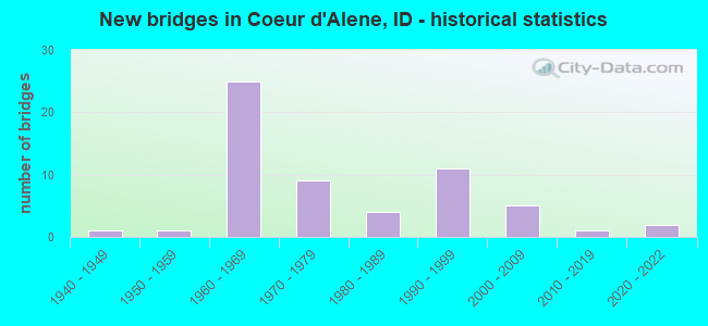
- New bridges - historical statistics
- 11940-1949
- 11950-1959
- 251960-1969
- 91970-1979
- 41980-1989
- 111990-1999
- 52000-2009
- 12010-2019
- 22020-2022

- Reconstructed bridges - Historical Statistics
- 11980-1989
- 11990-1999
- 22000-2009


- Bridge Condition - Deck
- 5.6%Excellent
- 19.4%Good
- 69.4%Satisfactory
- 5.6%Fair

- Bridge Condition - Superstructure
- 2.8%Excellent
- 22.2%Very good
- 19.4%Good
- 50.0%Satisfactory
- 5.6%Fair

- Bridge Condition - Substructure
- 2.8%Excellent
- 5.6%Very good
- 11.1%Good
- 63.9%Satisfactory
- 16.7%Fair

- Bridge Condition - Channel
- 11.1%Excellent
- 33.3%Very good
- 33.3%Good
- 22.2%Satisfactory
Find on map >> Show street view
Structure Number: 1318, Location: 3.3 SW. CAREY (Lat: 43.255806, Lng: -113.946103), Route carried "on" structure: US 93, Year Built: 1987, Status: Open, Structure Length: 1.25m (4.10ft), Average Daily Traffic: 820 (year 2019), Truck Traffic: 28%, Average Future Daily Traffic: 1,230 (year 2039), Design Load: HS 25 or greater, Features Intersected: LITTLE WOOD RIVER
Minimum Vertical Clearance: 30+ m (98+ ft), Kilometerpoint: 323.316, Lanes on structure: 2, Base Highway Network: Yes (Inventory Route: US0, Subroute: 3), Owner: State Highway Agency, Approaching Roadway Width: 10.4m (34.1ft), Skew: 2 degrees, Material/Design: Prestressed concrete, Design/Construction: Box Beam or Girders - Multiple, Number Of Spans In Main Unit: 1, Length of Maximum Span: 11.6m (38.1ft), Curb-To-Curb Width: 11.3m (37.1ft), Out-to-Out Width: 12.2m (40.0ft)
Condition: Deck: Excellent, Superstructure: Satisfactory, Substructure: Satisfactory, Channel: Very good, Operating Rating: 75.3 metric tons, Method Used To Determine Operating Rating: Load Factor (LF), Inventory Rating: 44.5 metric tons, Method Used To Determine Inventory Rating: Load Factor (LF), Structural Evaluation: Equal to present minimum criteria, Deck Geometry: Better than present minimum criteria, Waterway Adequacy: Equal to present desirable criteria, Approach Roadway Alignment: Equal to present desirable criteria, Designated Inspection Frequency: Every 48 months, Inspection Date: May 2018, Deck Structure Type: Concrete Cast-file-Place, Wearing Surface/Protective System: Wearing Surface: Latex Concrete, Deck Protection: Epoxy Coated Reinforcing
Find on map >> Show street view
Structure Number: 16795, Location: 3.8 W. COEUR D'ALENE (Lat: 47.707825, Lng: -116.850694), Route carried "on" structure: Interstate 90, Year Built: 1971, Status: Open, Structure Length: 3.47m (11.38ft), Average Daily Traffic: 29,500 (year 2019), Truck Traffic: 6%, Average Future Daily Traffic: 44,250 (year 2039), Design Load: HS 20, Features Intersected: HUETTER ROAD GS
Minimum Vertical Clearance: 30+ m (98+ ft), Kilometerpoint: 14.828, Lanes on structure: 2, Lanes under structure: 2, Base Highway Network: Yes (Inventory Route: I, Subroute: 1), Owner: State Highway Agency, Approaching Roadway Width: 11.6m (38.1ft), Skew: 2 degrees, Material/Design: Prestressed concrete, Design/Construction: Stringer/Multi-beam, Number Of Spans In Main Unit: 3, Length of Maximum Span: 12.8m (42.0ft), Curb-To-Curb Width: 11.6m (38.1ft), Out-to-Out Width: 12.4m (40.7ft)
Condition: Deck: Satisfactory, Superstructure: Satisfactory, Substructure: Satisfactory, Operating Rating: 48.1 metric tons, Method Used To Determine Operating Rating: Load Factor (LF), Inventory Rating: 28.1 metric tons, Method Used To Determine Inventory Rating: Load Factor (LF), Structural Evaluation: Equal to present minimum criteria, Deck Geometry: Equal to present minimum criteria, Underclear: High priority of corrective action, Approach Roadway Alignment: Equal to present desirable criteria, Designated Inspection Frequency: Every 48 months, Inspection Date: March 2018, Deck Structure Type: Concrete Cast-file-Place, Wearing Surface/Protective System: Wearing Surface: Bituminous
Find on map >> Show street view
Structure Number: 16805, Location: 2.6 W. COEUR D'ALENE (Lat: 47.702972, Lng: -116.828139), Route carried "on" structure: Interstate 90, Year Built: 1971, Status: Open, Structure Length: 2.93m (9.61ft), Average Daily Traffic: 29,500 (year 2019), Truck Traffic: 6%, Average Future Daily Traffic: 44,250 (year 2039), Design Load: HS 20, Features Intersected: ATLAS ROAD GS
Minimum Vertical Clearance: 30+ m (98+ ft), Kilometerpoint: 16.616, Lanes on structure: 2, Lanes under structure: 2, Base Highway Network: Yes (Inventory Route: I, Subroute: 1), Owner: State Highway Agency, Approaching Roadway Width: 11.6m (38.1ft), Skew: 1 degrees, Material/Design: Prestressed concrete, Design/Construction: Stringer/Multi-beam, Number Of Spans In Main Unit: 3, Length of Maximum Span: 12.8m (42.0ft), Curb-To-Curb Width: 11.6m (38.1ft), Out-to-Out Width: 12.4m (40.7ft)
Condition: Deck: Satisfactory, Superstructure: Satisfactory, Substructure: Satisfactory, Operating Rating: 48.1 metric tons, Method Used To Determine Operating Rating: Load Factor (LF), Inventory Rating: 28.1 metric tons, Method Used To Determine Inventory Rating: Load Factor (LF), Structural Evaluation: Equal to present minimum criteria, Deck Geometry: Equal to present minimum criteria, Underclear: High priority of replacement, Approach Roadway Alignment: Equal to present desirable criteria, Length Of Structure Improvement: 3.69m (12.11ft), Designated Inspection Frequency: Every 48 months, Inspection Date: March 2019, Bridge Improvement Cost: $839,000, Roadway Improvement Cost: $84,000, Total Project Cost: $1,258,000 ( Estimate for 2018), Deck Structure Type: Concrete Cast-file-Place, Wearing Surface/Protective System: Wearing Surface: Bituminous, Deck Protection: Epoxy Coated Reinforcing
Find on map >> Show street view
Structure Number: 1681, Location: 2.6 W. COEUR D'ALENE (Lat: 47.703111, Lng: -116.827778), Route carried "on" structure: Interstate 90, Year Built: 1971, Status: Open, Structure Length: 2.93m (9.61ft), Average Daily Traffic: 29,500 (year 2019), Truck Traffic: 6%, Average Future Daily Traffic: 44,250 (year 2039), Design Load: HS 20, Features Intersected: ATLAS ROAD GS
Minimum Vertical Clearance: 30+ m (98+ ft), Kilometerpoint: 16.618, Lanes on structure: 2, Lanes under structure: 2, Base Highway Network: Yes (Inventory Route: I, Subroute: 1), Owner: State Highway Agency, Approaching Roadway Width: 11.6m (38.1ft), Skew: 1 degrees, Material/Design: Prestressed concrete, Design/Construction: Stringer/Multi-beam, Number Of Spans In Main Unit: 3, Length of Maximum Span: 12.8m (42.0ft), Curb-To-Curb Width: 11.6m (38.1ft), Out-to-Out Width: 12.4m (40.7ft)
Condition: Deck: Satisfactory, Superstructure: Satisfactory, Substructure: Satisfactory, Operating Rating: 48.1 metric tons, Method Used To Determine Operating Rating: Load Factor (LF), Inventory Rating: 28.1 metric tons, Method Used To Determine Inventory Rating: Load Factor (LF), Structural Evaluation: Equal to present minimum criteria, Deck Geometry: Equal to present minimum criteria, Underclear: High priority of replacement, Approach Roadway Alignment: Equal to present desirable criteria, Length Of Structure Improvement: 3.69m (12.11ft), Designated Inspection Frequency: Every 48 months, Inspection Date: March 2019, Bridge Improvement Cost: $839,000, Roadway Improvement Cost: $84,000, Total Project Cost: $1,258,000 ( Estimate for 2018), Deck Structure Type: Concrete Cast-file-Place, Wearing Surface/Protective System: Wearing Surface: Bituminous
Find on map >> Show street view
Structure Number: 16815, Location: COEUR D'ALENE NWCL (Lat: 47.701000, Lng: -116.815722), Route carried "on" structure: Interstate 90, Year Built: 1971, Status: Open, Structure Length: 3.96m (12.99ft), Average Daily Traffic: 29,500 (year 2019), Truck Traffic: 6%, Average Future Daily Traffic: 44,250 (year 2039), Design Load: HS 20, Features Intersected: PEDESTRIAN/BIKE PATH
Minimum Vertical Clearance: 30+ m (98+ ft), Kilometerpoint: 17.576, Lanes on structure: 2, Base Highway Network: Yes (Inventory Route: I, Subroute: 1), Owner: State Highway Agency, Approaching Roadway Width: 11.6m (38.1ft), Skew: 3 degrees, Material/Design: Prestressed concrete, Design/Construction: Stringer/Multi-beam, Number Of Spans In Main Unit: 3, Length of Maximum Span: 13.4m (44.0ft), Curb-To-Curb Width: 11.6m (38.1ft), Out-to-Out Width: 12.4m (40.7ft)
Condition: Deck: Good, Superstructure: Very good, Substructure: Satisfactory, Operating Rating: 49.0 metric tons, Method Used To Determine Operating Rating: Load Factor (LF), Inventory Rating: 29.0 metric tons, Method Used To Determine Inventory Rating: Load Factor (LF), Structural Evaluation: Equal to present minimum criteria, Deck Geometry: Equal to present minimum criteria, Approach Roadway Alignment: Equal to present desirable criteria, Designated Inspection Frequency: Every 48 months, Inspection Date: March 2019, Deck Structure Type: Concrete Cast-file-Place, Wearing Surface/Protective System: Wearing Surface: Latex Concrete
Find on map >> Show street view
Structure Number: 1682, Location: COEUR D'ALENE NWCL (Lat: 47.701056, Lng: -116.815000), Route carried "on" structure: Interstate 90, Year Built: 1971, Status: Open, Structure Length: 3.96m (12.99ft), Average Daily Traffic: 29,500 (year 2019), Truck Traffic: 6%, Average Future Daily Traffic: 44,250 (year 2039), Design Load: HS 20, Features Intersected: PEDESTRIAN/BIKE PATH
Minimum Vertical Clearance: 30+ m (98+ ft), Kilometerpoint: 17.577, Lanes on structure: 2, Base Highway Network: Yes (Inventory Route: I, Subroute: 1), Owner: State Highway Agency, Approaching Roadway Width: 11.6m (38.1ft), Skew: 3 degrees, Material/Design: Prestressed concrete, Design/Construction: Stringer/Multi-beam, Number Of Spans In Main Unit: 3, Length of Maximum Span: 13.4m (44.0ft), Curb-To-Curb Width: 11.6m (38.1ft), Out-to-Out Width: 12.4m (40.7ft)
Condition: Deck: Good, Superstructure: Very good, Substructure: Fair, Operating Rating: 49.0 metric tons, Method Used To Determine Operating Rating: Load Factor (LF), Inventory Rating: 29.0 metric tons, Method Used To Determine Inventory Rating: Load Factor (LF), Structural Evaluation: Somewhat better than minimum adequacy, Deck Geometry: Equal to present minimum criteria, Approach Roadway Alignment: Equal to present desirable criteria, Designated Inspection Frequency: Every 24 months, Inspection Date: March 2021, Deck Structure Type: Concrete Cast-file-Place, Wearing Surface/Protective System: Wearing Surface: Latex Concrete
Find on map >> Show street view
Structure Number: 16855, Location: IN COUER D'ALENE;15TH ST. (Lat: 47.688611, Lng: -116.765000), Route carried "on" structure: Interstate 90, Year Built: 1960, Status: Open, Structure Length: 3.17m (10.40ft), Average Daily Traffic: 11,750 (year 2019), Truck Traffic: 15%, Average Future Daily Traffic: 17,625 (year 2039), Design Load: HS 20, Features Intersected: SMA 7335;FIFTEENTH ST.IC
Minimum Vertical Clearance: 30+ m (98+ ft), Kilometerpoint: 21.808, Lanes on structure: 2, Lanes under structure: 3, Base Highway Network: Yes (Inventory Route: I, Subroute: 1), Owner: State Highway Agency, Approaching Roadway Width: 15.8m (51.8ft), Skew: 5 degrees, Material/Design: Prestressed concrete, Design/Construction: Stringer/Multi-beam, Number Of Spans In Main Unit: 1, Length of Maximum Span: 31.7m (104.0ft), Curb-To-Curb Width: 11.6m (38.1ft), Out-to-Out Width: 12.2m (40.0ft)
Condition: Deck: Satisfactory, Superstructure: Good, Substructure: Satisfactory, Operating Rating: 59.0 metric tons, Method Used To Determine Operating Rating: Load Factor (LF), Inventory Rating: 36.3 metric tons, Method Used To Determine Inventory Rating: Load Factor (LF), Structural Evaluation: Equal to present minimum criteria, Deck Geometry: Equal to present minimum criteria, Underclear: Meets minimum limits, Approach Roadway Alignment: Equal to present desirable criteria, Length Of Structure Improvement: 4.11m (13.48ft), Designated Inspection Frequency: Every 24 months, Inspection Date: March 2020, Bridge Improvement Cost: $936,000, Roadway Improvement Cost: $94,000, Total Project Cost: $1,403,000 ( Estimate for 2020), Deck Structure Type: Concrete Cast-file-Place, Wearing Surface/Protective System: Wearing Surface: Bituminous
Find on map >> Show street view
Structure Number: 1686, Location: IN COEUR D'ALENE;15TH ST. (Lat: 47.688622, Lng: -116.764747), Route carried "on" structure: Interstate 90, Year Built: 1960, Status: Open, Structure Length: 3.17m (10.40ft), Average Daily Traffic: 11,750 (year 2019), Truck Traffic: 15%, Average Future Daily Traffic: 17,625 (year 2039), Design Load: HS 20, Features Intersected: SMA 7335;FIFTEENTH ST.IC
Minimum Vertical Clearance: 30+ m (98+ ft), Kilometerpoint: 21.810, Lanes on structure: 2, Lanes under structure: 3, Base Highway Network: Yes (Inventory Route: I, Subroute: 1), Owner: State Highway Agency, Approaching Roadway Width: 15.8m (51.8ft), Skew: 5 degrees, Material/Design: Prestressed concrete, Design/Construction: Stringer/Multi-beam, Number Of Spans In Main Unit: 1, Length of Maximum Span: 31.7m (104.0ft), Curb-To-Curb Width: 11.6m (38.1ft), Out-to-Out Width: 12.2m (40.0ft)
Condition: Deck: Satisfactory, Superstructure: Satisfactory, Substructure: Satisfactory, Operating Rating: 59.0 metric tons, Method Used To Determine Operating Rating: Load Factor (LF), Inventory Rating: 36.3 metric tons, Method Used To Determine Inventory Rating: Load Factor (LF), Structural Evaluation: Equal to present minimum criteria, Deck Geometry: Equal to present minimum criteria, Underclear: Meets minimum limits, Approach Roadway Alignment: Equal to present desirable criteria, Length Of Structure Improvement: 4.11m (13.48ft), Designated Inspection Frequency: Every 24 months, Inspection Date: March 2020, Bridge Improvement Cost: $935,000, Roadway Improvement Cost: $94,000, Total Project Cost: $1,403,000 ( Estimate for 2020), Deck Structure Type: Concrete Cast-file-Place, Wearing Surface/Protective System: Wearing Surface: Bituminous
Find on map >> Show street view
Structure Number: 16865, Location: IN COEUR D'ALENE;ELM AVE. (Lat: 47.683667, Lng: -116.760139), Route carried "on" structure: Interstate 90, Year Built: 1960, Status: Open, Structure Length: 4.30m (14.11ft), Average Daily Traffic: 11,750 (year 2019), Truck Traffic: 15%, Average Future Daily Traffic: 17,625 (year 2039), Design Load: HS 20, Features Intersected: STC 7325;ELM AVE.GS
Minimum Vertical Clearance: 30+ m (98+ ft), Kilometerpoint: 22.491, Lanes on structure: 2, Lanes under structure: 2, Base Highway Network: Yes (Inventory Route: I, Subroute: 1), Owner: State Highway Agency, Approaching Roadway Width: 15.8m (51.8ft), Skew: 3 degrees, Material/Design: Concrete, Design/Construction: Stringer/Multi-beam, Number Of Spans In Main Unit: 3, Length of Maximum Span: 14.0m (45.9ft), Curb-To-Curb Width: 11.6m (38.1ft), Out-to-Out Width: 12.2m (40.0ft)
Condition: Deck: Satisfactory, Superstructure: Satisfactory, Substructure: Satisfactory, Operating Rating: 57.2 metric tons, Method Used To Determine Operating Rating: Load Factor (LF), Inventory Rating: 34.5 metric tons, Method Used To Determine Inventory Rating: Load Factor (LF), Structural Evaluation: Equal to present minimum criteria, Deck Geometry: Equal to present minimum criteria, Underclear: Somewhat better than minimum adequacy, Approach Roadway Alignment: Equal to present desirable criteria, Length Of Structure Improvement: 5.15m (16.90ft), Designated Inspection Frequency: Every 48 months, Inspection Date: March 2018, Bridge Improvement Cost: $1,060,000, Roadway Improvement Cost: $106,000, Total Project Cost: $1,590,000, Deck Structure Type: Concrete Cast-file-Place, Wearing Surface/Protective System: Wearing Surface: Bituminous
Find on map >> Show street view
Structure Number: 1687, Location: IN COEUR D'ALENE;ELM AVE. (Lat: 47.683328, Lng: -116.759539), Route carried "on" structure: Interstate 90, Year Built: 1960, Status: Open, Structure Length: 4.30m (14.11ft), Average Daily Traffic: 11,750 (year 2019), Truck Traffic: 15%, Average Future Daily Traffic: 17,625 (year 2039), Design Load: HS 20, Features Intersected: STC 7325;ELM AVE.GS
Minimum Vertical Clearance: 30+ m (98+ ft), Kilometerpoint: 22.492, Lanes on structure: 2, Lanes under structure: 2, Base Highway Network: Yes (Inventory Route: I, Subroute: 1), Owner: State Highway Agency, Approaching Roadway Width: 15.8m (51.8ft), Skew: 3 degrees, Material/Design: Concrete, Design/Construction: Stringer/Multi-beam, Number Of Spans In Main Unit: 3, Length of Maximum Span: 14.0m (45.9ft), Curb-To-Curb Width: 11.6m (38.1ft), Out-to-Out Width: 12.2m (40.0ft)
Condition: Deck: Satisfactory, Superstructure: Satisfactory, Substructure: Satisfactory, Operating Rating: 57.2 metric tons, Method Used To Determine Operating Rating: Load Factor (LF), Inventory Rating: 34.5 metric tons, Method Used To Determine Inventory Rating: Load Factor (LF), Structural Evaluation: Equal to present minimum criteria, Deck Geometry: Equal to present minimum criteria, Underclear: Meets minimum limits, Approach Roadway Alignment: Equal to present desirable criteria, Length Of Structure Improvement: 5.15m (16.90ft), Designated Inspection Frequency: Every 48 months, Inspection Date: March 2018, Bridge Improvement Cost: $1,060,000, Roadway Improvement Cost: $106,000, Total Project Cost: $1,590,000, Deck Structure Type: Concrete Cast-file-Place, Wearing Surface/Protective System: Wearing Surface: Bituminous
Find on map >> Show street view
Structure Number: 16876, Location: COEUR D' ALENE ECL (Lat: 47.679167, Lng: -116.755611), Route carried "on" structure: Interstate 90, Year Built: 2020, Status: Open, Structure Length: 5.06m (16.60ft), Average Daily Traffic: 23,500 (year 2020), Truck Traffic: 15%, Average Future Daily Traffic: 35,250 (year 2040), Design Load: HL 93, Features Intersected: STC7405; PENN AVE GS
Minimum Vertical Clearance: 30+ m (98+ ft), Kilometerpoint: 23.083, Lanes on structure: 4, Lanes under structure: 2, Base Highway Network: Yes (Inventory Route: I, Subroute: 1), Owner: State Highway Agency, Approaching Roadway Width: 29.3m (96.1ft), Skew: 33 degrees, Material/Design: Prestressed concrete, Design/Construction: Stringer/Multi-beam, Number Of Spans In Main Unit: 3, Length of Maximum Span: 21.3m (69.9ft), Curb-To-Curb Width: 29.3m (96.1ft), Out-to-Out Width: 30.7m (100.7ft)
Condition: Deck: Excellent, Superstructure: Excellent, Substructure: Excellent, Operating Rating: 47.3 metric tons, Method Used To Determine Operating Rating: Load and Resistance Factor Rating (LRFR) rating reported by rating factor(RF) method using HL-93 loadings, Inventory Rating: 36.3 metric tons, Method Used To Determine Inventory Rating: Load and Resistance Factor Rating (LRFR) rating reported by rating factor(RF) method using HL-93 loadings, Structural Evaluation: Superior to present desirable criteria, Deck Geometry: Superior to present desirable criteria, Underclear: Better than present minimum criteria, Approach Roadway Alignment: Equal to present desirable criteria, Designated Inspection Frequency: Every 24 months, Inspection Date: March 2021, Deck Structure Type: Concrete Precast Panels, Wearing Surface/Protective System: Wearing Surface: Latex Concrete, Deck Protection: Epoxy Coated Reinforcing
Find on map >> Show street view
Structure Number: 16885, Location: IN COEUR D'ALENE;SHERMAN (Lat: 47.673389, Lng: -116.751361), Route carried "on" structure: Interstate 90, Year Built: 1960, Status: Open, Structure Length: 1.65m (5.41ft), Average Daily Traffic: 11,750 (year 2019), Truck Traffic: 15%, Average Future Daily Traffic: 17,625 (year 2039), Design Load: HS 20, Features Intersected: SMA 7445;SHERMAN AVE.IC
Minimum Vertical Clearance: 30+ m (98+ ft), Kilometerpoint: 23.778, Lanes on structure: 2, Lanes under structure: 3, Base Highway Network: Yes (Inventory Route: I, Subroute: 1), Owner: State Highway Agency, Approaching Roadway Width: 15.8m (51.8ft), Skew: 1 degrees, Material/Design: Concrete, Design/Construction: Tee Beam, Number Of Spans In Main Unit: 1, Length of Maximum Span: 16.5m (54.1ft), Curb-To-Curb Width: 11.6m (38.1ft), Out-to-Out Width: 12.2m (40.0ft)
Condition: Deck: Satisfactory, Superstructure: Satisfactory, Substructure: Fair, Operating Rating: 43.5 metric tons, Method Used To Determine Operating Rating: Load Factor (LF), Inventory Rating: 25.4 metric tons, Method Used To Determine Inventory Rating: Load Factor (LF), Structural Evaluation: Somewhat better than minimum adequacy, Deck Geometry: Equal to present minimum criteria, Underclear: High priority of replacement, Approach Roadway Alignment: Equal to present desirable criteria, Length Of Structure Improvement: 2.53m (8.30ft), Designated Inspection Frequency: Every 24 months, Inspection Date: March 2020, Bridge Improvement Cost: $575,000, Roadway Improvement Cost: $58,000, Total Project Cost: $863,000 ( Estimate for 2020), Deck Structure Type: Concrete Cast-file-Place, Wearing Surface/Protective System: Wearing Surface: Bituminous
Find on map >> Show street view
Structure Number: 1689, Location: IN COEUR D'ALENE;SHERMAN (Lat: 47.673236, Lng: -116.751081), Route carried "on" structure: Interstate 90, Year Built: 1960, Status: Open, Structure Length: 1.65m (5.41ft), Average Daily Traffic: 11,750 (year 2019), Truck Traffic: 15%, Average Future Daily Traffic: 17,625 (year 2039), Design Load: HS 20, Features Intersected: SMA 7445;SHERMAN AVE.IC
Minimum Vertical Clearance: 30+ m (98+ ft), Kilometerpoint: 23.780, Lanes on structure: 2, Lanes under structure: 2, Base Highway Network: Yes (Inventory Route: I, Subroute: 1), Owner: State Highway Agency, Approaching Roadway Width: 15.8m (51.8ft), Skew: 1 degrees, Material/Design: Concrete, Design/Construction: Tee Beam, Number Of Spans In Main Unit: 1, Length of Maximum Span: 16.5m (54.1ft), Curb-To-Curb Width: 11.6m (38.1ft), Out-to-Out Width: 12.2m (40.0ft)
Condition: Deck: Satisfactory, Superstructure: Satisfactory, Substructure: Satisfactory, Operating Rating: 43.5 metric tons, Method Used To Determine Operating Rating: Load Factor (LF), Inventory Rating: 25.4 metric tons, Method Used To Determine Inventory Rating: Load Factor (LF), Structural Evaluation: Equal to present minimum criteria, Deck Geometry: Equal to present minimum criteria, Underclear: High priority of replacement, Approach Roadway Alignment: Equal to present desirable criteria, Length Of Structure Improvement: 2.53m (8.30ft), Designated Inspection Frequency: Every 24 months, Inspection Date: March 2020, Bridge Improvement Cost: $575,000, Roadway Improvement Cost: $58,000, Total Project Cost: $863,000 ( Estimate for 2020), Deck Structure Type: Concrete Cast-file-Place, Wearing Surface/Protective System: Wearing Surface: Bituminous
Find on map >> Show street view
Structure Number: 16894, Location: 0.5 S. COEUR D'ALENE (Lat: 47.666028, Lng: -116.750611), Route carried "on" structure: Interstate 90, Year Built: 1992, Status: Open, Structure Length: 7.25m (23.79ft), Average Daily Traffic: 14,000 (year 2019), Truck Traffic: 18%, Average Future Daily Traffic: 21,000 (year 2039), Design Load: HS 25 or greater, Features Intersected: POTLATCH HILL RD. GS
Minimum Vertical Clearance: 30+ m (98+ ft), Kilometerpoint: 24.587, Lanes on structure: 4, Lanes under structure: 2, Base Highway Network: Yes (Inventory Route: I, Subroute: 2), Owner: State Highway Agency, Approaching Roadway Width: 23.8m (78.1ft), Skew: 35 degrees, Material/Design: Prestressed concrete continuous, Design/Construction: Stringer/Multi-beam, Number Of Spans In Main Unit: 3, Length of Maximum Span: 28.0m (91.9ft), Curb-To-Curb Width: 24.0m (78.7ft), Out-to-Out Width: 25.5m (83.7ft)
Condition: Deck: Satisfactory, Superstructure: Very good, Substructure: Satisfactory, Operating Rating: 71.7 metric tons, Method Used To Determine Operating Rating: Load Factor (LF), Inventory Rating: 39.9 metric tons, Method Used To Determine Inventory Rating: Load Factor (LF), Structural Evaluation: Equal to present minimum criteria, Deck Geometry: Superior to present desirable criteria, Underclear: Meets minimum limits, Approach Roadway Alignment: Equal to present desirable criteria, Length Of Structure Improvement: 8.17m (26.80ft), Designated Inspection Frequency: Every 48 months, Inspection Date: September 2018, Bridge Improvement Cost: $3,626,000, Roadway Improvement Cost: $363,000, Total Project Cost: $5,439,000 ( Estimate for 2018), Deck Structure Type: Concrete Cast-file-Place, Wearing Surface/Protective System: Wearing Surface: Monolithic Concrete, Deck Protection: Epoxy Coated Reinforcing
Find on map >> Show street view
Structure Number: 16896, Location: 2.0E. 2.0S. COEUR D'ALENE (Lat: 47.649500, Lng: -116.715000), Route carried "on" structure: Interstate 90, Year Built: 1991, Status: Open, Structure Length: 52.73m (173.00ft), Average Daily Traffic: 12,500 (year 2019), Truck Traffic: 19%, Average Future Daily Traffic: 18,750 (year 2039), Design Load: HS 25 or greater, Features Intersected: BENNETT BAY;SUNNYSIDE RD
Minimum Vertical Clearance: 30+ m (98+ ft), Kilometerpoint: 28.405, Lanes on structure: 4, Lanes under structure: 2, Base Highway Network: Yes (Inventory Route: I, Subroute: 2), Owner: State Highway Agency, Approaching Roadway Width: 32.0m (105.0ft), Skew: 30 degrees, Material/Design: Prestressed concrete continuous, Design/Construction: Segmental Box Girder, Number Of Spans In Main Unit: 4, Length of Maximum Span: 158.5m (520.0ft), Curb-To-Curb Width: 24.0m (78.7ft), Out-to-Out Width: 25.5m (83.7ft)
Condition: Deck: Good, Superstructure: Good, Substructure: Satisfactory, Channel: Excellent, Operating Rating: 59.0 metric tons, Method Used To Determine Operating Rating: Load Factor (LF), Inventory Rating: 44.5 metric tons, Method Used To Determine Inventory Rating: Load Factor (LF), Structural Evaluation: Equal to present minimum criteria, Deck Geometry: Superior to present desirable criteria, Underclear: Meets minimum limits, Waterway Adequacy: Superior to present desirable criteria, Approach Roadway Alignment: Equal to present desirable criteria, Length Of Structure Improvement: 52.73m (173.00ft), Designated Inspection Frequency: Every 24 months, Inspection Date: May 2021, Bridge Improvement Cost: $24,000,000, Roadway Improvement Cost: $2,400,000, Total Project Cost: $36,000,000 ( Estimate for 2017), Deck Structure Type: Concrete Cast-file-Place, Wearing Surface/Protective System: Wearing Surface: Epoxy Overlay, Deck Protection: Epoxy Coated Reinforcing
Find on map >> Show street view
Structure Number: 16897, Location: 4.0E. 4.0S. COEUR D'ALENE (Lat: 47.638528, Lng: -116.707944), Route carried "on" structure: Interstate 90, Year Built: 1992, Status: Open, Structure Length: 6.43m (21.10ft), Average Daily Traffic: 12,500 (year 2019), Truck Traffic: 19%, Average Future Daily Traffic: 18,750 (year 2039), Design Load: HS 25 or greater, Features Intersected: TIMOTHY LN;EVERGREEN GS
Minimum Vertical Clearance: 30+ m (98+ ft), Kilometerpoint: 29.823, Lanes on structure: 4, Lanes under structure: 2, Base Highway Network: Yes (Inventory Route: I, Subroute: 2), Owner: State Highway Agency, Approaching Roadway Width: 23.8m (78.1ft), Skew: 34 degrees, Material/Design: Prestressed concrete, Design/Construction: Stringer/Multi-beam, Number Of Spans In Main Unit: 3, Length of Maximum Span: 25.9m (85.0ft), Curb-To-Curb Width: 23.4m (76.8ft), Out-to-Out Width: 25.5m (83.7ft)
Condition: Deck: Satisfactory, Superstructure: Very good, Substructure: Good, Operating Rating: 76.2 metric tons, Method Used To Determine Operating Rating: Load Factor (LF), Inventory Rating: 45.4 metric tons, Method Used To Determine Inventory Rating: Load Factor (LF), Structural Evaluation: Better than present minimum criteria, Deck Geometry: Superior to present desirable criteria, Underclear: Better than present minimum criteria, Approach Roadway Alignment: Equal to present desirable criteria, Length Of Structure Improvement: 7.38m (24.21ft), Designated Inspection Frequency: Every 48 months, Inspection Date: September 2018, Bridge Improvement Cost: $3,274,000, Roadway Improvement Cost: $327,000, Total Project Cost: $4,911,000 ( Estimate for 2018), Deck Structure Type: Concrete Cast-file-Place, Wearing Surface/Protective System: Wearing Surface: Epoxy Overlay, Deck Protection: Epoxy Coated Reinforcing
Find on map >> Show street view
Structure Number: 16898, Location: 2.5S. 2.5E. COEUR D'ALENE (Lat: 47.632139, Lng: -116.705944), Route carried "on" structure: County highway , Year Built: 1991, Status: Open, Structure Length: 8.23m (27.00ft), Average Daily Traffic: 350 (year 2019), Truck Traffic: 14%, Average Future Daily Traffic: 525 (year 2039), Design Load: HS 25 or greater, Features Intersected: I90;YELLOWSTONE TRAIL GS, Facility Carried by Structure: YELLOWSTONE TRAIL
Minimum Vertical Clearance: 30+ m (98+ ft), Kilometerpoint: 161.047, Lanes on structure: 2, Lanes under structure: 4, Owner: State Highway Agency, Approaching Roadway Width: 9.1m (29.9ft), Skew: 5 degrees, Material/Design: Prestressed concrete continuous, Design/Construction: Box Beam or Girders - Single/Spread, Number Of Spans In Main Unit: 2, Length of Maximum Span: 45.7m (149.9ft), Curb-To-Curb Width: 9.4m (30.8ft), Out-to-Out Width: 10.4m (34.1ft)
Condition: Deck: Good, Superstructure: Good, Substructure: Satisfactory, Operating Rating: 54.4 metric tons, Method Used To Determine Operating Rating: Load and Resistance Factor (LRFR), Inventory Rating: 39.9 metric tons, Method Used To Determine Inventory Rating: Load and Resistance Factor (LRFR), Structural Evaluation: Equal to present minimum criteria, Deck Geometry: Equal to present minimum criteria, Underclear: High priority of corrective action, Approach Roadway Alignment: Equal to present desirable criteria, Designated Inspection Frequency: Every 48 months, Inspection Date: March 2021, Deck Structure Type: Concrete Cast-file-Place, Wearing Surface/Protective System: Wearing Surface: Epoxy Overlay, Deck Protection: Epoxy Coated Reinforcing
Find on map >> Show street view
Structure Number: 16899, Location: 1.0 E. COEUR D'ALENE (Lat: 47.655250, Lng: -116.727750), Route carried "on" structure: County highway , Year Built: 1991, Status: Open, Structure Length: 6.98m (22.90ft), Average Daily Traffic: 1,300 (year 2019), Average Future Daily Traffic: 1,950 (year 2039), Design Load: HS 25 or greater, Features Intersected: I90;MULLAN TRAIL RD IC, Facility Carried by Structure: MULLAN TRAIL RD
Minimum Vertical Clearance: 30+ m (98+ ft), Kilometerpoint: 161.278, Lanes on structure: 2, Lanes under structure: 4, Owner: State Highway Agency, Approaching Roadway Width: 10.4m (34.1ft), Material/Design: Concrete continuous, Design/Construction: Box Beam or Girders - Single/Spread, Number Of Spans In Main Unit: 2, Length of Maximum Span: 36.9m (121.1ft), Curb-To-Curb Width: 11.2m (36.7ft), Out-to-Out Width: 12.1m (39.7ft)
Condition: Deck: Satisfactory, Superstructure: Satisfactory, Substructure: Satisfactory, Operating Rating: 41.7 metric tons, Method Used To Determine Operating Rating: Load and Resistance Factor (LRFR), Inventory Rating: 32.7 metric tons, Method Used To Determine Inventory Rating: Load and Resistance Factor (LRFR), Structural Evaluation: Equal to present minimum criteria, Deck Geometry: Equal to present minimum criteria, Underclear: Somewhat better than minimum adequacy, Approach Roadway Alignment: Equal to present desirable criteria, Designated Inspection Frequency: Every 48 months, Inspection Date: March 2021, Deck Structure Type: Concrete Cast-file-Place, Wearing Surface/Protective System: Wearing Surface: Epoxy Overlay, Deck Protection: Epoxy Coated Reinforcing
Find on map >> Show street view
Structure Number: 16901, Location: 6.0E. 4.0S. COUER D'ALENE (Lat: 47.630222, Lng: -116.686472), Route carried "on" structure: Interstate 90, Year Built: 1992, Status: Open, Structure Length: 4.08m (13.39ft), Average Daily Traffic: 12,500 (year 2019), Truck Traffic: 19%, Average Future Daily Traffic: 18,750 (year 2039), Design Load: HS 25 or greater, Features Intersected: BLUE CREEK BAY WEST GS
Minimum Vertical Clearance: 30+ m (98+ ft), Kilometerpoint: 32.056, Lanes on structure: 4, Base Highway Network: Yes (Inventory Route: I, Subroute: 2), Owner: State Highway Agency, Approaching Roadway Width: 23.8m (78.1ft), Skew: 32 degrees, Material/Design: Concrete, Design/Construction: Stringer/Multi-beam, Number Of Spans In Main Unit: 1, Length of Maximum Span: 40.8m (133.9ft), Curb-To-Curb Width: 24.0m (78.7ft), Out-to-Out Width: 25.5m (83.7ft)
Condition: Deck: Satisfactory, Superstructure: Very good, Substructure: Satisfactory, Inventory Rating: 53.5 metric tons, Method Used To Determine Inventory Rating: Load Factor (LF), Structural Evaluation: Equal to present minimum criteria, Deck Geometry: Superior to present desirable criteria, Approach Roadway Alignment: Equal to present desirable criteria, Length Of Structure Improvement: 4.97m (16.31ft), Designated Inspection Frequency: Every 48 months, Inspection Date: September 2018, Bridge Improvement Cost: $2,205,000, Roadway Improvement Cost: $221,000, Total Project Cost: $3,308,000 ( Estimate for 2018), Deck Structure Type: Concrete Cast-file-Place, Wearing Surface/Protective System: Wearing Surface: Monolithic Concrete, Deck Protection: Epoxy Coated Reinforcing
Find on map >> Show street view
Structure Number: 16905, Location: 7.7 E. COEUR D'ALENE (Lat: 47.628056, Lng: -116.679444), Route carried "on" structure: Interstate 90, Year Built: 1972, Status: Open, Structure Length: 40.20m (131.89ft), Average Daily Traffic: 6,250 (year 2019), Truck Traffic: 19%, Average Future Daily Traffic: 9,375 (year 2039), Design Load: HS 20, Features Intersected: CD'A LAKE;BLUE CREEK BAY
Minimum Vertical Clearance: 30+ m (98+ ft), Kilometerpoint: 32.637, Lanes on structure: 2, Base Highway Network: Yes (Inventory Route: I, Subroute: 1), Owner: State Highway Agency, Approaching Roadway Width: 12.2m (40.0ft), Navigation Control: Yes ( Vertical Clearance: 7.0m (23.0ft), Horizontal Clearance: 37.0m (121.4ft)), Material/Design: Steel continuous, Design/Construction: Stringer/Multi-beam, Number Of Spans In Main Unit: 10, Length of Maximum Span: 32.2m (105.6ft), Curb-To-Curb Width: 12.0m (39.4ft), Out-to-Out Width: 12.7m (41.7ft)
Condition: Deck: Good, Superstructure: Satisfactory, Substructure: Satisfactory, Channel: Good, Operating Rating: 66.2 metric tons, Method Used To Determine Operating Rating: Load Factor (LF), Inventory Rating: 39.0 metric tons, Method Used To Determine Inventory Rating: Load Factor (LF), Structural Evaluation: Equal to present minimum criteria, Deck Geometry: Equal to present minimum criteria, Waterway Adequacy: Superior to present desirable criteria, Approach Roadway Alignment: Equal to present desirable criteria, Designated Inspection Frequency: Every 24 months, Underwater Inspection Frequency: Every 60 months, Other Special Inspection Frequency: Every 48 months, Inspection Date: March 2020, Underwater Inspection Date: December 2021, Other Special Inspection Date: March 2018, Deck Structure Type: Concrete Cast-file-Place, Wearing Surface/Protective System: Wearing Surface: Latex Concrete
Find on map >> Show street view
Structure Number: 17336, Location: COEUR D ALENE WCL (Lat: 47.699583, Lng: -116.807528), Route carried "on" structure: Business Interstate 90, Year Built: 2001, Status: Open, Structure Length: 5.58m (18.31ft), Average Daily Traffic: 33,000 (year 2019), Truck Traffic: 2%, Average Future Daily Traffic: 49,500 (year 2039), Design Load: HS 25 or greater, Features Intersected: I 90 EB-WB;NW BLVD IC
Minimum Vertical Clearance: 5.26m (17.26ft), Kilometerpoint: 0.111, Lanes on structure: 7, Lanes under structure: 4, Owner: State Highway Agency, Approaching Roadway Width: 25.3m (83.0ft), Skew: 2 degrees, Material/Design: Prestressed concrete continuous, Design/Construction: Stringer/Multi-beam, Number Of Spans In Main Unit: 2, Length of Maximum Span: 27.4m (89.9ft), Curb or Sidewalk Widths: Left: 1.5m (4.9ft), Right: 1.5m (4.9ft), Curb-To-Curb Width: 28.8m (94.5ft), Out-to-Out Width: 32.3m (106.0ft)
Condition: Deck: Satisfactory, Superstructure: Very good, Substructure: Very good, Operating Rating: 88.9 metric tons, Method Used To Determine Operating Rating: Load Factor (LF), Inventory Rating: 39.9 metric tons, Method Used To Determine Inventory Rating: Load Factor (LF), Structural Evaluation: Equal to present desirable criteria, Deck Geometry: Somewhat better than minimum adequacy, Underclear: Equal to present minimum criteria, Approach Roadway Alignment: Equal to present desirable criteria, Designated Inspection Frequency: Every 48 months, Inspection Date: March 2021, Deck Structure Type: Concrete Cast-file-Place, Wearing Surface/Protective System: Wearing Surface: Monolithic Concrete, Deck Protection: Epoxy Coated Reinforcing
Find on map >> Show street view
Structure Number: 1793, Location: 1.0 N. NORTH FORK (Lat: 45.420278, Lng: -113.994972), Route carried "on" structure: US 93, Year Built: 1955, Status: Open, Structure Length: 1.80m (5.91ft), Average Daily Traffic: 670 (year 2019), Truck Traffic: 19%, Average Future Daily Traffic: 1,005 (year 2039), Design Load: HS 20, Features Intersected: N.FK.SALMON RIVER
Minimum Vertical Clearance: 30+ m (98+ ft), Kilometerpoint: 526.665, Lanes on structure: 2, Base Highway Network: Yes (Inventory Route: US0, Subroute: 1), Owner: State Highway Agency, Approaching Roadway Width: 8.2m (26.9ft), Skew: 2 degrees, Material/Design: Concrete, Design/Construction: Tee Beam, Number Of Spans In Main Unit: 1, Length of Maximum Span: 16.2m (53.1ft), Curb-To-Curb Width: 8.5m (27.9ft), Out-to-Out Width: 9.8m (32.2ft)
Condition: Deck: Satisfactory, Superstructure: Satisfactory, Substructure: Satisfactory, Channel: Satisfactory, Operating Rating: 56.2 metric tons, Method Used To Determine Operating Rating: Load Factor (LF), Inventory Rating: 33.6 metric tons, Method Used To Determine Inventory Rating: Load Factor (LF), Structural Evaluation: Equal to present minimum criteria, Deck Geometry: Somewhat better than minimum adequacy, Waterway Adequacy: Equal to present minimum criteria, Approach Roadway Alignment: Equal to present desirable criteria, Length Of Structure Improvement: 2.44m (8.01ft), Designated Inspection Frequency: Every 48 months, Inspection Date: October 2018, Bridge Improvement Cost: $528,000, Roadway Improvement Cost: $53,000, Total Project Cost: $792,000 ( Estimate for 2018), Deck Structure Type: Concrete Cast-file-Place, Wearing Surface/Protective System: Wearing Surface: Bituminous
Find on map >> Show street view
Structure Number: 1867, Location: 4.1 S. COEUR D'ALENE (Lat: 47.658111, Lng: -116.840028), Route carried "on" structure: US 95, Year Built: 1985, Status: Open, Structure Length: 2.23m (7.32ft), Average Daily Traffic: 9,400 (year 2019), Truck Traffic: 10%, Average Future Daily Traffic: 14,100 (year 2039), Design Load: HS 25 or greater, Features Intersected: COUGAR CREEK
Minimum Vertical Clearance: 30+ m (98+ ft), Kilometerpoint: 686.369, Lanes on structure: 3, Base Highway Network: Yes (Inventory Route: US0, Subroute: 1), Owner: State Highway Agency, Approaching Roadway Width: 15.8m (51.8ft), Skew: 4 degrees, Material/Design: Prestressed concrete, Design/Construction: Stringer/Multi-beam, Number Of Spans In Main Unit: 1, Length of Maximum Span: 21.0m (68.9ft), Curb-To-Curb Width: 16.7m (54.8ft), Out-to-Out Width: 17.6m (57.7ft)
Condition: Deck: Satisfactory, Superstructure: Very good, Substructure: Good, Channel: Good, Operating Rating: 70.8 metric tons, Method Used To Determine Operating Rating: Load Factor (LF), Inventory Rating: 43.5 metric tons, Method Used To Determine Inventory Rating: Load Factor (LF), Structural Evaluation: Better than present minimum criteria, Deck Geometry: Superior to present desirable criteria, Waterway Adequacy: Superior to present desirable criteria, Approach Roadway Alignment: Equal to present desirable criteria, Designated Inspection Frequency: Every 48 months, Inspection Date: August 2021, Deck Structure Type: Concrete Cast-file-Place, Wearing Surface/Protective System: Wearing Surface: Bituminous
Find on map >> Show street view
Structure Number: 18675, Location: 1.3 S. COEUR D'ALENE (Lat: 47.681167, Lng: -116.806583), Route carried "on" structure: US 95, Year Built: 1969, Status: Open, Structure Length: 3.72m (12.20ft), Average Daily Traffic: 12,500 (year 2019), Truck Traffic: 6%, Average Future Daily Traffic: 18,750 (year 2039), Design Load: HS 20, Features Intersected: BLACKWELL SLOUGH
Minimum Vertical Clearance: 30+ m (98+ ft), Kilometerpoint: 690.386, Lanes on structure: 2, Base Highway Network: Yes (Inventory Route: US0, Subroute: 1), Owner: State Highway Agency, Approaching Roadway Width: 12.8m (42.0ft), Skew: 4 degrees, Navigation Control: Yes ( Vertical Clearance: 3.0m (9.8ft), Horizontal Clearance: 9.1m (29.9ft)), Material/Design: Concrete, Design/Construction: Stringer/Multi-beam, Number Of Spans In Main Unit: 3, Length of Maximum Span: 13.4m (44.0ft), Curb-To-Curb Width: 12.2m (40.0ft), Out-to-Out Width: 13.1m (43.0ft)
Condition: Deck: Satisfactory, Superstructure: Satisfactory, Substructure: Satisfactory, Channel: Very good, Operating Rating: 54.4 metric tons, Method Used To Determine Operating Rating: Load Factor (LF), Inventory Rating: 32.7 metric tons, Method Used To Determine Inventory Rating: Load Factor (LF), Structural Evaluation: Equal to present minimum criteria, Deck Geometry: Somewhat better than minimum adequacy, Waterway Adequacy: Superior to present desirable criteria, Approach Roadway Alignment: Equal to present desirable criteria, Length Of Structure Improvement: 4.57m (14.99ft), Designated Inspection Frequency: Every 48 months, Inspection Date: April 2020, Bridge Improvement Cost: $1,535,000, Roadway Improvement Cost: $154,000, Total Project Cost: $2,302,000 ( Estimate for 2020), Deck Structure Type: Concrete Cast-file-Place, Wearing Surface/Protective System: Wearing Surface: Latex Concrete
Find on map >> Show street view
Structure Number: 1868, Location: WCL COEUR D'ALENE (Lat: 47.685472, Lng: -116.800889), Route carried "on" structure: US 95, Year Built: 1968, Year Reconstructed: 1998, Status: Open, Structure Length: 31.03m (101.80ft), Average Daily Traffic: 12,500 (year 2019), Truck Traffic: 6%, Average Future Daily Traffic: 18,750 (year 2039), Design Load: HS 20, Features Intersected: SPOKANE R;PED/BIKE PATH
Minimum Vertical Clearance: 30+ m (98+ ft), Kilometerpoint: 691.057, Lanes on structure: 2, Base Highway Network: Yes (Inventory Route: US0, Subroute: 1), Owner: State Highway Agency, Approaching Roadway Width: 12.5m (41.0ft), Navigation Control: Yes ( Vertical Clearance: 12.2m (40.0ft), Horizontal Clearance: 38.0m (124.7ft)), Material/Design: Steel, Design/Construction: Stringer/Multi-beam, Number Of Spans In Main Unit: 9, Number Of Approach Spans: 1, Length of Maximum Span: 39.3m (128.9ft), Curb or Sidewalk Widths: Left: 0.5m (1.6ft), Right: 0.6m (2.0ft), Curb-To-Curb Width: 9.8m (32.2ft), Out-to-Out Width: 11.2m (36.7ft)
Condition: Deck: Satisfactory, Superstructure: Satisfactory, Substructure: Fair, Channel: Good, Operating Rating: 52.6 metric tons, Method Used To Determine Operating Rating: Load Factor (LF), Inventory Rating: 31.8 metric tons, Method Used To Determine Inventory Rating: Load Factor (LF), Structural Evaluation: Somewhat better than minimum adequacy, Deck Geometry: Meets minimum limits, Waterway Adequacy: Superior to present desirable criteria, Approach Roadway Alignment: Equal to present desirable criteria, Length Of Structure Improvement: 31.09m (102.00ft), Designated Inspection Frequency: Every 24 months, Underwater Inspection Frequency: Every 60 months, Other Special Inspection Frequency: Every 48 months, Inspection Date: April 2020, Underwater Inspection Date: October 2021, Other Special Inspection Date: April 2020, Bridge Improvement Cost: $10,435,000, Roadway Improvement Cost: $1,044,000, Total Project Cost: $15,652,000 ( Estimate for 2020), Deck Structure Type: Concrete Cast-file-Place, Wearing Surface/Protective System: Wearing Surface: Latex Concrete
Find on map >> Show street view
Structure Number: 18685, Location: IN COEUR D'ALENE (Lat: 47.687000, Lng: -116.796833), Route carried "on" structure: US 95, Year Built: 1968, Status: Open, Structure Length: 2.59m (8.50ft), Average Daily Traffic: 12,500 (year 2019), Truck Traffic: 5%, Average Future Daily Traffic: 18,750 (year 2039), Design Load: HS 20, Features Intersected: I 90B;NW BLVD;US 95 IC
Minimum Vertical Clearance: 30+ m (98+ ft), Kilometerpoint: 691.405, Lanes on structure: 3, Lanes under structure: 4, Base Highway Network: Yes (Inventory Route: US0, Subroute: 1), Owner: State Highway Agency, Approaching Roadway Width: 14.9m (48.9ft), Material/Design: Steel, Design/Construction: Stringer/Multi-beam, Number Of Spans In Main Unit: 1, Length of Maximum Span: 25.9m (85.0ft), Curb or Sidewalk Widths: Left: 0.2m (0.7ft), Right: 1.5m (4.9ft), Curb-To-Curb Width: 14.9m (48.9ft), Out-to-Out Width: 17.3m (56.8ft)
Condition: Deck: Fair, Superstructure: Satisfactory, Substructure: Satisfactory, Operating Rating: 83.5 metric tons, Method Used To Determine Operating Rating: Load Factor (LF), Inventory Rating: 49.9 metric tons, Method Used To Determine Inventory Rating: Load Factor (LF), Structural Evaluation: Equal to present minimum criteria, Deck Geometry: Equal to present minimum criteria, Underclear: Meets minimum limits, Approach Roadway Alignment: Equal to present desirable criteria, Designated Inspection Frequency: Every 24 months, Other Special Inspection Frequency: Every 48 months, Inspection Date: April 2020, Other Special Inspection Date: April 2018, Deck Structure Type: Concrete Cast-file-Place, Wearing Surface/Protective System: Wearing Surface: Monolithic Concrete
Find on map >> Show street view
Structure Number: 1869, Location: IN COEUR D'ALENE (Lat: 47.698528, Lng: -116.791694), Route carried "on" structure: US 95, Year Built: 1960, Year Reconstructed: 2009, Status: Open, Structure Length: 5.85m (19.19ft), Average Daily Traffic: 36,500 (year 2019), Truck Traffic: 4%, Average Future Daily Traffic: 54,750 (year 2039), Design Load: HS 20, Features Intersected: I 90 E-WB;LINCOLN WAY IC
Minimum Vertical Clearance: 30+ m (98+ ft), Kilometerpoint: 692.969, Lanes on structure: 5, Lanes under structure: 4, Base Highway Network: Yes (Inventory Route: US0, Subroute: 1), Owner: State Highway Agency, Approaching Roadway Width: 22.9m (75.1ft), Material/Design: Prestressed concrete, Design/Construction: Stringer/Multi-beam, Number Of Spans In Main Unit: 4, Length of Maximum Span: 18.0m (59.1ft), Curb or Sidewalk Widths: Left: 0.2m (0.7ft), Right: 0.2m (0.7ft), Curb-To-Curb Width: 20.1m (65.9ft), Out-to-Out Width: 21.6m (70.9ft)
Condition: Deck: Satisfactory, Superstructure: Fair, Substructure: Satisfactory, Operating Rating: 44.5 metric tons, Method Used To Determine Operating Rating: Load Factor (LF), Inventory Rating: 26.3 metric tons, Method Used To Determine Inventory Rating: Load Factor (LF), Structural Evaluation: Somewhat better than minimum adequacy, Deck Geometry: Somewhat better than minimum adequacy, Underclear: Equal to present minimum criteria, Approach Roadway Alignment: Equal to present desirable criteria, Length Of Structure Improvement: 7.01m (23.00ft), Designated Inspection Frequency: Every 24 months, Inspection Date: April 2021, Bridge Improvement Cost: $2,350,000, Roadway Improvement Cost: $235,000, Total Project Cost: $3,525,000 ( Estimate for 2017), Deck Structure Type: Concrete Cast-file-Place, Wearing Surface/Protective System: Wearing Surface: Latex Concrete
Find on map >> Show street view
Structure Number: 1981, Location: 2.0 S. 2.8 E. MERIDIAN (Lat: 43.584889, Lng: -116.334375), Route carried "on" structure: County highway 7013, Year Built: 1969, Status: Open, Structure Length: 1.04m (3.41ft), Average Daily Traffic: 12,000 (year 2019), Truck Traffic: 3%, Average Future Daily Traffic: 18,000 (year 2039), Design Load: HS 20, Features Intersected: RIDENBAUGH CANAL
Minimum Vertical Clearance: 30+ m (98+ ft), Kilometerpoint: 10.709, Lanes on structure: 2, Owner: County Highway Agency, Approaching Roadway Width: 12.2m (40.0ft), Skew: 3 degrees, Material/Design: Prestressed concrete, Design/Construction: Tee Beam, Number Of Spans In Main Unit: 1, Length of Maximum Span: 9.8m (32.2ft), Curb-To-Curb Width: 9.2m (30.2ft), Out-to-Out Width: 9.8m (32.2ft)
Condition: Deck: Good, Superstructure: Good, Substructure: Fair, Channel: Very good, Operating Rating: 57.2 metric tons, Method Used To Determine Operating Rating: Load Factor (LF), Inventory Rating: 30.8 metric tons, Method Used To Determine Inventory Rating: Load Factor (LF), Structural Evaluation: Somewhat better than minimum adequacy, Deck Geometry: High priority of corrective action, Waterway Adequacy: Somewhat better than minimum adequacy, Approach Roadway Alignment: Equal to present desirable criteria, Length Of Structure Improvement: 1.71m (5.61ft), Designated Inspection Frequency: Every 24 months, Inspection Date: Febuary 2020, Bridge Improvement Cost: $573,000, Roadway Improvement Cost: $57,000, Total Project Cost: $860,000 ( Estimate for 2018), Deck Structure Type: Concrete Cast-file-Place, Wearing Surface/Protective System: Wearing Surface: Bituminous
Find on map >> Show street view
Structure Number: 21331, Location: IN COEUR D' ALENE (Lat: 47.698083, Lng: -116.786306), Route carried "on" structure: City street 7155, Year Built: 2006, Status: Open, Structure Length: 5.33m (17.49ft), Average Daily Traffic: 38,000 (year 2019), Truck Traffic: 10%, Average Future Daily Traffic: 57,000 (year 2039), Design Load: HL 93, Features Intersected: I 90 EB-WB; GOVT WAY GS
Minimum Vertical Clearance: 30+ m (98+ ft), Kilometerpoint: 18.662, Lanes on structure: 4, Lanes under structure: 4, Owner: State Highway Agency, Approaching Roadway Width: 14.4m (47.2ft), Skew: 1 degrees, Material/Design: Steel continuous, Design/Construction: Stringer/Multi-beam, Number Of Spans In Main Unit: 2, Length of Maximum Span: 25.9m (85.0ft), Curb or Sidewalk Widths: Left: 1.5m (4.9ft), Right: 1.5m (4.9ft), Curb-To-Curb Width: 18.0m (59.1ft), Out-to-Out Width: 21.5m (70.5ft)
Condition: Deck: Satisfactory, Superstructure: Very good, Substructure: Very good, Operating Rating: 78.9 metric tons, Method Used To Determine Operating Rating: Load Factor (LF), Inventory Rating: 47.2 metric tons, Method Used To Determine Inventory Rating: Load Factor (LF), Structural Evaluation: Equal to present desirable criteria, Deck Geometry: Somewhat better than minimum adequacy, Underclear: Equal to present minimum criteria, Approach Roadway Alignment: Equal to present desirable criteria, Designated Inspection Frequency: Every 48 months, Inspection Date: April 2018, Deck Structure Type: Concrete Cast-file-Place, Wearing Surface/Protective System: Wearing Surface: Monolithic Concrete, Deck Protection: Epoxy Coated Reinforcing
Find on map >> Show street view
Structure Number: 21365, Location: IN COEUR D'ALENE;4TH ST. (Lat: 47.697194, Lng: -116.780806), Route carried "on" structure: City street 7195, Year Built: 1985, Status: Open, Structure Length: 6.25m (20.51ft), Average Daily Traffic: 22,500 (year 2019), Truck Traffic: 2%, Average Future Daily Traffic: 33,750 (year 2039), Design Load: HS 20, Features Intersected: I 90 EB-WB;4TH ST.IC
Minimum Vertical Clearance: 5.79m (19.00ft), Kilometerpoint: 2.638, Lanes on structure: 5, Lanes under structure: 4, Owner: State Highway Agency, Approaching Roadway Width: 25.0m (82.0ft), Skew: 1 degrees, Material/Design: Steel continuous, Design/Construction: Stringer/Multi-beam, Number Of Spans In Main Unit: 2, Length of Maximum Span: 30.5m (100.1ft), Curb or Sidewalk Widths: Left: 2.1m (6.9ft), Right: 2.1m (6.9ft), Curb-To-Curb Width: 24.9m (81.7ft), Out-to-Out Width: 30.1m (98.8ft)
Condition: Deck: Satisfactory, Superstructure: Good, Substructure: Satisfactory, Operating Rating: 49.0 metric tons, Method Used To Determine Operating Rating: Load Factor (LF), Inventory Rating: 29.0 metric tons, Method Used To Determine Inventory Rating: Load Factor (LF), Structural Evaluation: Equal to present minimum criteria, Deck Geometry: Superior to present desirable criteria, Underclear: Somewhat better than minimum adequacy, Approach Roadway Alignment: Equal to present desirable criteria, Designated Inspection Frequency: Every 24 months, Other Special Inspection Frequency: Every 72 months, Inspection Date: April 2021, Other Special Inspection Date: April 2019, Deck Structure Type: Concrete Cast-file-Place, Wearing Surface/Protective System: Wearing Surface: Monolithic Concrete, Deck Protection: Epoxy Coated Reinforcing
Find on map >> Show street view
Structure Number: 214, Location: IN COEUR D'ALENE (Lat: 47.695139, Lng: -116.772944), Route carried "on" structure: City street , Year Built: 1960, Year Reconstructed: 2009, Status: Open, Structure Length: 6.98m (22.90ft), Average Daily Traffic: 2,400 (year 2019), Average Future Daily Traffic: 3,600 (year 2039), Design Load: HS 20, Features Intersected: I 90 EB-WB;9TH ST GS, Facility Carried by Structure: 9TH ST
Minimum Vertical Clearance: 30+ m (98+ ft), Kilometerpoint: 18.723, Lanes on structure: 2, Lanes under structure: 4, Owner: State Highway Agency, Approaching Roadway Width: 12.2m (40.0ft), Skew: 3 degrees, Material/Design: Steel continuous, Design/Construction: Stringer/Multi-beam, Number Of Spans In Main Unit: 2, Number Of Approach Spans: 2, Length of Maximum Span: 21.6m (70.9ft), Curb or Sidewalk Widths: Left: 1.5m (4.9ft), Right: 1.5m (4.9ft), Curb-To-Curb Width: 12.2m (40.0ft), Out-to-Out Width: 15.1m (49.5ft)
Condition: Deck: Satisfactory, Superstructure: Good, Substructure: Fair, Operating Rating: 59.9 metric tons, Method Used To Determine Operating Rating: Load Factor (LF), Inventory Rating: 35.4 metric tons, Method Used To Determine Inventory Rating: Load Factor (LF), Structural Evaluation: Somewhat better than minimum adequacy, Deck Geometry: Equal to present minimum criteria, Underclear: Somewhat better than minimum adequacy, Approach Roadway Alignment: Equal to present desirable criteria, Length Of Structure Improvement: 9.20m (30.18ft), Designated Inspection Frequency: Every 24 months, Inspection Date: April 2021, Bridge Improvement Cost: $1,993,000, Roadway Improvement Cost: $200,000, Total Project Cost: $3,000,000 ( Estimate for 2021), Deck Structure Type: Concrete Cast-file-Place, Wearing Surface/Protective System: Wearing Surface: Monolithic Concrete
Find on map >> Show street view
Structure Number: 30425, Location: 0.9S. 2.5W. COEUR D'ALENE (Lat: 47.659333, Lng: -116.835778), Route carried "on" structure: County highway , Year Built: 1940, Year Reconstructed: 1989, Status: Posted for load, Structure Length: 1.01m (3.31ft), Average Daily Traffic: 10 (year 2019), Truck Traffic: 10%, Average Future Daily Traffic: 15 (year 2039), Design Load: H 10, Features Intersected: COUGAR CREEK, Facility Carried by Structure: S MCAVOY ROAD
Minimum Vertical Clearance: 30+ m (98+ ft), Kilometerpoint: 160.973, Lanes on structure: 1, Owner: Local Agency, Approaching Roadway Width: 3.7m (12.1ft), Material/Design: Wood or Timber, Design/Construction: Stringer/Multi-beam, Number Of Spans In Main Unit: 1, Length of Maximum Span: 9.4m (30.8ft), Curb-To-Curb Width: 5.0m (16.4ft), Out-to-Out Width: 5.0m (16.4ft)
Condition: Deck: Good, Superstructure: Satisfactory, Substructure: Good, Channel: Satisfactory, Operating Rating: 32.7 metric tons, Method Used To Determine Operating Rating: Allowable Stress (AS), Inventory Rating: 24.5 metric tons, Method Used To Determine Inventory Rating: Allowable Stress (AS), Structural Evaluation: Equal to present minimum criteria, Deck Geometry: High priority of corrective action, Waterway Adequacy: Equal to present minimum criteria, Approach Roadway Alignment: Meets minimum limits, Length Of Structure Improvement: 1.62m (5.31ft), Designated Inspection Frequency: Every 24 months, Inspection Date: August 2021, Bridge Improvement Cost: $245,000, Roadway Improvement Cost: $25,000, Total Project Cost: $368,000 ( Estimate for 2019), Deck Structure Type: Wood or Timber, Wearing Surface/Protective System: Wearing Surface: Wood or Timber
Find on map >> Show street view
Structure Number: 30541, Location: AT COEUR D'ALENE WCL (Lat: 47.700528, Lng: -116.816556), Route carried "on" structure: County highway 7605, Year Built: 2007, Status: Open, Structure Length: 5.03m (16.50ft), Average Daily Traffic: 13,000 (year 2019), Truck Traffic: 2%, Average Future Daily Traffic: 19,500 (year 2039), Design Load: HS 25 or greater, Features Intersected: SELTICE WAY PED OP
Minimum Vertical Clearance: 30+ m (98+ ft), Kilometerpoint: 8.690, Lanes on structure: 4, Owner: City or Municipal Highway Agency, Approaching Roadway Width: 19.2m (63.0ft), Skew: 4 degrees, Material/Design: Concrete, Design/Construction: Stringer/Multi-beam, Number Of Spans In Main Unit: 1, Number Of Approach Spans: 2, Length of Maximum Span: 22.9m (75.1ft), Curb-To-Curb Width: 20.2m (66.3ft), Out-to-Out Width: 21.0m (68.9ft)
Condition: Deck: Satisfactory, Superstructure: Good, Substructure: Satisfactory, Operating Rating: 90.6 metric tons, Method Used To Determine Operating Rating: Load Factor (LF), Inventory Rating: 46.3 metric tons, Method Used To Determine Inventory Rating: Load Factor (LF), Structural Evaluation: Equal to present minimum criteria, Deck Geometry: Better than present minimum criteria, Approach Roadway Alignment: Equal to present desirable criteria, Designated Inspection Frequency: Every 48 months, Inspection Date: June 2019, Deck Structure Type: Concrete Cast-file-Place, Wearing Surface/Protective System: Wearing Surface: Monolithic Concrete
Find on map >> Show street view
Structure Number: 30615, Location: COEUR D'ALENE (Lat: 47.696167, Lng: -116.775639), Route carried "on" structure: City street , Year Built: 1960, Status: Open, Structure Length: 6.43m (21.10ft), Average Daily Traffic: 2,800 (year 2019), Average Future Daily Traffic: 4,200 (year 2039), Design Load: HS 20, Features Intersected: I 90 EB-WB;7TH ST GS, Facility Carried by Structure: 7TH STREET
Minimum Vertical Clearance: 30+ m (98+ ft), Kilometerpoint: 161.140, Lanes on structure: 2, Lanes under structure: 4, Owner: State Highway Agency, Approaching Roadway Width: 12.2m (40.0ft), Skew: 2 degrees, Material/Design: Prestressed concrete, Design/Construction: Stringer/Multi-beam, Number Of Spans In Main Unit: 4, Length of Maximum Span: 19.2m (63.0ft), Curb or Sidewalk Widths: Left: 1.2m (3.9ft), Right: 1.2m (3.9ft), Curb-To-Curb Width: 12.2m (40.0ft), Out-to-Out Width: 15.1m (49.5ft)
Condition: Deck: Satisfactory, Superstructure: Satisfactory, Substructure: Satisfactory, Operating Rating: 49.0 metric tons, Method Used To Determine Operating Rating: Load Factor (LF), Inventory Rating: 29.9 metric tons, Method Used To Determine Inventory Rating: Load Factor (LF), Structural Evaluation: Equal to present minimum criteria, Deck Geometry: Equal to present minimum criteria, Underclear: Somewhat better than minimum adequacy, Approach Roadway Alignment: Equal to present desirable criteria, Designated Inspection Frequency: Every 24 months, Inspection Date: April 2020, Deck Structure Type: Concrete Cast-file-Place, Wearing Surface/Protective System: Wearing Surface: Monolithic Concrete
Find on map >> Show street view
Structure Number: 3062, Location: 0.9 E. COEUR D'ALENE (Lat: 47.661694, Lng: -116.749139), Route carried "on" structure: County highway , Year Built: 1960, Status: Open, Structure Length: 5.18m (16.99ft), Average Daily Traffic: 150 (year 2019), Truck Traffic: 10%, Average Future Daily Traffic: 225 (year 2039), Design Load: HS 20, Features Intersected: SMA 7235;POTLATCH RD GS, Facility Carried by Structure: POTLATCH HILL ROAD
Minimum Vertical Clearance: 30+ m (98+ ft), Kilometerpoint: 162.454, Lanes on structure: 2, Lanes under structure: 4, Owner: State Highway Agency, Approaching Roadway Width: 8.5m (27.9ft), Material/Design: Prestressed concrete, Design/Construction: Stringer/Multi-beam, Number Of Spans In Main Unit: 2, Number Of Approach Spans: 2, Length of Maximum Span: 17.1m (56.1ft), Curb or Sidewalk Widths: Left: 0.2m (0.7ft), Right: 0.2m (0.7ft), Curb-To-Curb Width: 8.5m (27.9ft), Out-to-Out Width: 10.0m (32.8ft)
Condition: Deck: Fair, Superstructure: Fair, Substructure: Fair, Operating Rating: 47.2 metric tons, Method Used To Determine Operating Rating: Load Factor (LF), Inventory Rating: 28.1 metric tons, Method Used To Determine Inventory Rating: Load Factor (LF), Structural Evaluation: Somewhat better than minimum adequacy, Deck Geometry: Equal to present minimum criteria, Underclear: Meets minimum limits, Approach Roadway Alignment: High priority of corrective action, Length Of Structure Improvement: 6.22m (20.41ft), Designated Inspection Frequency: Every 24 months, Inspection Date: March 2021, Bridge Improvement Cost: $1,414,000, Roadway Improvement Cost: $141,000, Total Project Cost: $2,121,000 ( Estimate for 2021), Deck Structure Type: Concrete Cast-file-Place, Wearing Surface/Protective System: Wearing Surface: Monolithic Concrete
Find on map >> Show street view
Structure Number: 37, Location: IN COEUR D'ALENE (Lat: 47.672611, Lng: -116.781861), Route carried "on" structure: City street , Year Built: 2014, Status: Open, Structure Length: 26.55m (87.11ft), Average Daily Traffic: 6,049 (year 2019), Truck Traffic: 5%, Average Future Daily Traffic: 9,074 (year 2039), Design Load: HS 20, Features Intersected: CDA PARKING GARAGE, Facility Carried by Structure: FRONT AVENUE
Minimum Vertical Clearance: 30+ m (98+ ft), Kilometerpoint: 161.092, Lanes on structure: 2, Owner: City or Municipal Highway Agency, Approaching Roadway Width: 7.9m (25.9ft), Material/Design: Concrete, Design/Construction: Slab, Number Of Spans In Main Unit: 30, Length of Maximum Span: 12.5m (41.0ft), Curb or Sidewalk Widths: Left: 4.9m (16.1ft), Right: 3.7m (12.1ft), Curb-To-Curb Width: 13.5m (44.3ft), Out-to-Out Width: 20.1m (65.9ft)
Condition: Deck: Satisfactory, Superstructure: Satisfactory, Substructure: Good, Operating Rating: 36.3 metric tons, Method Used To Determine Operating Rating: Load Factor (LF), Inventory Rating: 21.8 metric tons, Method Used To Determine Inventory Rating: Load Factor (LF), Structural Evaluation: Somewhat better than minimum adequacy, Deck Geometry: Superior to present desirable criteria, Approach Roadway Alignment: Equal to present desirable criteria, Designated Inspection Frequency: Every 24 months, Inspection Date: October 2021, Deck Structure Type: Concrete Cast-file-Place, Wearing Surface/Protective System: Wearing Surface: Bituminous, Membrane: Preformed Fabric, Deck Protection: Epoxy Coated Reinforcing
Find on map >> Show street view
Structure Number: 16795, Location: 3.8 W. COEUR D'ALENE (Lat: 47.707825, Lng: -116.850694), Route carried "under" structure: County highway 7125, Year Built: 1971, Structure Length: 0. m, Average Daily Traffic: 3,200 (year 2018), Features Intersected: HUETTER ROAD GS, Facility Carried by Structure: I 90 WBL
Minimum Vertical Clearance: 4.65m (15.26ft), Kilometerpoint: 161.649, Lanes on structure: 2, Lanes under structure: 2, Material/Design: Prestressed concrete, Design/Construction: Stringer/Multi-beam, Length of Maximum Span: 12.8m (42.0ft)
Find on map >> Show street view
Structure Number: 16805, Location: 2.6 W. COEUR D'ALENE (Lat: 47.702972, Lng: -116.828139), Route carried "under" structure: County highway 7145, Year Built: 1971, Structure Length: 0. m, Average Daily Traffic: 8,200 (year 2018), Truck Traffic: 7%, Features Intersected: ATLAS ROAD GS, Facility Carried by Structure: I 90 EBL
Minimum Vertical Clearance: 4.52m (14.83ft), Kilometerpoint: 16.303, Lanes on structure: 2, Lanes under structure: 2, Material/Design: Prestressed concrete, Design/Construction: Stringer/Multi-beam, Length of Maximum Span: 12.8m (42.0ft)
Find on map >> Show street view
Structure Number: 1681, Location: 2.6 W. COEUR D'ALENE (Lat: 47.703111, Lng: -116.827778), Route carried "under" structure: County highway 7145, Year Built: 1971, Structure Length: 0. m, Average Daily Traffic: 8,200 (year 2018), Truck Traffic: 7%, Features Intersected: ATLAS ROAD GS, Facility Carried by Structure: I 90 WBL
Minimum Vertical Clearance: 4.37m (14.34ft), Kilometerpoint: 16.319, Lanes on structure: 2, Lanes under structure: 2, Material/Design: Prestressed concrete, Design/Construction: Stringer/Multi-beam, Length of Maximum Span: 12.8m (42.0ft)
Find on map >> Show street view
Structure Number: 16855, Location: IN COUER D'ALENE;15TH ST. (Lat: 47.688611, Lng: -116.765000), Route carried "under" structure: City street 7335, Year Built: 1960, Structure Length: 0. m, Average Daily Traffic: 11,500 (year 2018), Features Intersected: SMA 7335;FIFTEENTH ST.IC, Facility Carried by Structure: I 90 EBL
Minimum Vertical Clearance: 4.67m (15.32ft), Kilometerpoint: 17.775, Lanes on structure: 2, Lanes under structure: 2, Material/Design: Prestressed concrete, Design/Construction: Stringer/Multi-beam, Length of Maximum Span: 31.7m (104.0ft)