Bridge Statistics for Burlington, New Jersey (NJ)
Condition, Traffic, Stress, Structural Evaluation, Project Costs
- National Bridge Inventory (NBI) Statistics
- 46Number of bridges
- 633ft / 193mTotal length
- $18,840,000Total costs
- 1,497,415Total average daily traffic
- 147,355Total average daily truck traffic
- National Bridge Inventory (NBI) Registered Bridges for Burlington
- No street view available for this location
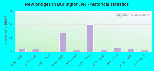
- New bridges - historical statistics
- 21920-1929
- 21930-1939
- 141950-1959
- 11960-1969
- 201970-1979
- 11980-1989
- 31990-1999
- 22000-2009
- 12010-2019

- Reconstructed bridges - Historical Statistics
- 11960-1969
- 01970-1979
- 11980-1989
- 21990-1999
- 12000-2009


- Bridge Condition - Deck
- 3.3%Very good
- 40.0%Good
- 40.0%Satisfactory
- 13.3%Fair
- 3.3%Poor

- Bridge Condition - Superstructure
- 3.3%Very good
- 40.0%Good
- 26.7%Satisfactory
- 20.0%Fair
- 10.0%Poor

- Bridge Condition - Substructure
- 6.7%Very good
- 26.7%Good
- 50.0%Satisfactory
- 10.0%Fair
- 6.7%Poor

- Bridge Condition - Channel
- 13.3%Very good
- 26.7%Good
- 26.7%Satisfactory
- 33.3%Fair
Find on map >> Show street view
Structure Number: 31715, Location: 0.2 MI N OF RT670 (Lat: 40.074169, Lng: -74.848431), Route carried "on" structure: US 130, Year Built: 1963, Status: Open, Structure Length: 3.05m (10.01ft), Average Daily Traffic: 23,380 (year 2020), Truck Traffic: 4%, Average Future Daily Traffic: 32,180 (year 2040), Design Load: HS 20, Features Intersected: ASSISCUNK CREEK
Minimum Vertical Clearance: 30+ m (98+ ft), Kilometerpoint: 75.076, Lanes on structure: 3, Base Highway Network: Yes, Owner: State Highway Agency, Approaching Roadway Width: 14.3m (46.9ft), Material/Design: Prestressed concrete, Design/Construction: Box Beam or Girders - Multiple, Number Of Spans In Main Unit: 2, Length of Maximum Span: 14.6m (47.9ft), Curb or Sidewalk Widths: Left: 1.2m (3.9ft), Right: 2.0m (6.6ft), Curb-To-Curb Width: 14.3m (46.9ft), Out-to-Out Width: 18.1m (59.4ft)
Condition: Deck: Fair, Superstructure: Good, Substructure: Satisfactory, Channel: Very good, Operating Rating: 77.1 metric tons, Method Used To Determine Operating Rating: Load Factor (LF), Inventory Rating: 39.0 metric tons, Method Used To Determine Inventory Rating: Load Factor (LF), Structural Evaluation: Equal to present minimum criteria, Deck Geometry: Somewhat better than minimum adequacy, Waterway Adequacy: Superior to present desirable criteria, Approach Roadway Alignment: Equal to present minimum criteria, Length Of Structure Improvement: 3.05m (10.01ft), Designated Inspection Frequency: Every 24 months, Underwater Inspection Frequency: Every 24 months, Inspection Date: December 2020, Underwater Inspection Date: April 2021, Bridge Improvement Cost: $612,000, Total Project Cost: $612,000 ( Estimate for 2021), Deck Structure Type: Concrete Cast-file-Place, Wearing Surface/Protective System: Wearing Surface: Monolithic Concrete
Find on map >> Show street view
Structure Number: 317152, Location: 0.5 MI N OF RT541 (Lat: 40.074481, Lng: -74.848969), Route carried "on" structure: US 130, Year Built: 1935, Year Reconstructed: 2006, Status: Open, Structure Length: 3.17m (10.40ft), Average Daily Traffic: 23,352 (year 2020), Truck Traffic: 4%, Average Future Daily Traffic: 28,023 (year 2040), Features Intersected: ASSISCUNK CREEK
Minimum Vertical Clearance: 30.45m (99.90ft), Kilometerpoint: 75.076, Lanes on structure: 2, Base Highway Network: Yes, Owner: State Highway Agency, Approaching Roadway Width: 9.8m (32.2ft), Skew: 2 degrees, Navigation Control: Yes ( Vertical Clearance: 1.5m (4.9ft), Horizontal Clearance: 1.2m (3.9ft)), Material/Design: Steel, Design/Construction: Stringer/Multi-beam, Number Of Spans In Main Unit: 2, Length of Maximum Span: 14.6m (47.9ft), Curb or Sidewalk Widths: Left: 1.9m (6.2ft), Right: 0.0m, Curb-To-Curb Width: 9.8m (32.2ft), Out-to-Out Width: 12.5m (41.0ft)
Condition: Deck: Good, Superstructure: Satisfactory, Substructure: Poor, Channel: Good, Inventory Rating: 73.5 metric tons, Method Used To Determine Inventory Rating: Load Factor (LF), Structural Evaluation: Meets minimum limits, Deck Geometry: Meets minimum limits, Waterway Adequacy: Equal to present minimum criteria, Approach Roadway Alignment: Better than present minimum criteria, Length Of Structure Improvement: 3.17m (10.40ft), Designated Inspection Frequency: Every 24 months, Underwater Inspection Frequency: Every 24 months, Inspection Date: September 2020, Underwater Inspection Date: April 2020, Bridge Improvement Cost: $2,207,000, Roadway Improvement Cost: $221,000, Total Project Cost: $3,700,000 ( Estimate for 2020), Deck Structure Type: Concrete Cast-file-Place, Wearing Surface/Protective System: Wearing Surface: Monolithic Concrete, Deck Protection: Epoxy Coated Reinforcing
Find on map >> Show street view
Structure Number: 327169, Location: 4.3 MI NORTH OF RT 38 (Lat: 40.009081, Lng: -74.851111), Route carried "on" structure: County highway 626, Year Built: 1971, Status: Open, Structure Length: 9.14m (29.99ft), Average Daily Traffic: 4,905 (year 2020), Truck Traffic: 4%, Average Future Daily Traffic: 5,985 (year 2040), Design Load: HS 20, Features Intersected: I-295, Facility Carried by Structure: RANCOCAS-MT HOLLY
Minimum Vertical Clearance: 30+ m (98+ ft), Kilometerpoint: 10.074, Lanes on structure: 6, Lanes under structure: 9, Base Highway Network: Yes, Owner: State Highway Agency, Approaching Roadway Width: 22.3m (73.2ft), Skew: 24 degrees, Material/Design: Steel, Design/Construction: Stringer/Multi-beam, Number Of Spans In Main Unit: 2, Length of Maximum Span: 47.9m (157.2ft), Curb or Sidewalk Widths: Left: 0.5m (1.6ft), Right: 1.8m (5.9ft), Curb-To-Curb Width: 22.3m (73.2ft), Out-to-Out Width: 27.3m (89.6ft)
Condition: Deck: Satisfactory, Superstructure: Good, Substructure: Good, Operating Rating: 68.0 metric tons, Method Used To Determine Operating Rating: Load Factor (LF), Inventory Rating: 40.8 metric tons, Method Used To Determine Inventory Rating: Load Factor (LF), Structural Evaluation: Better than present minimum criteria, Deck Geometry: Meets minimum limits, Underclear: High priority of corrective action, Approach Roadway Alignment: Equal to present desirable criteria, Length Of Structure Improvement: 9.14m (29.99ft), Designated Inspection Frequency: Every 24 months, Inspection Date: May 2020, Bridge Improvement Cost: $831,000, Roadway Improvement Cost: $195,000, Total Project Cost: $1,250,000 ( Estimate for 2020), Deck Structure Type: Concrete Cast-file-Place, Wearing Surface/Protective System: Wearing Surface: Monolithic Concrete
Find on map >> Show street view
Structure Number: 32717, Location: 5.4 MI NORTH OF RT 38 (Lat: 40.022031, Lng: -74.845050), Route carried "on" structure: County highway 630, Year Built: 1971, Status: Open, Structure Length: 6.28m (20.60ft), Average Daily Traffic: 7,812 (year 2020), Truck Traffic: 4%, Average Future Daily Traffic: 9,532 (year 2040), Design Load: HS 20, Features Intersected: I-295
Minimum Vertical Clearance: 30+ m (98+ ft), Kilometerpoint: 8.851, Lanes on structure: 2, Lanes under structure: 6, Owner: State Highway Agency, Approaching Roadway Width: 12.2m (40.0ft), Material/Design: Steel, Design/Construction: Stringer/Multi-beam, Number Of Spans In Main Unit: 2, Length of Maximum Span: 30.8m (101.0ft), Curb or Sidewalk Widths: Left: 0.5m (1.6ft), Right: 1.8m (5.9ft), Curb-To-Curb Width: 9.1m (29.9ft), Out-to-Out Width: 12.0m (39.4ft)
Condition: Deck: Satisfactory, Superstructure: Fair, Substructure: Good, Operating Rating: 61.7 metric tons, Method Used To Determine Operating Rating: Load Factor (LF), Inventory Rating: 37.2 metric tons, Method Used To Determine Inventory Rating: Load Factor (LF), Structural Evaluation: Somewhat better than minimum adequacy, Deck Geometry: Meets minimum limits, Underclear: High priority of corrective action, Approach Roadway Alignment: Better than present minimum criteria, Length Of Structure Improvement: 6.28m (20.60ft), Designated Inspection Frequency: Every 24 months, Inspection Date: June 2020, Bridge Improvement Cost: $821,000, Roadway Improvement Cost: $169,000, Total Project Cost: $1,280,000 ( Estimate for 2020), Deck Structure Type: Concrete Cast-file-Place, Wearing Surface/Protective System: Wearing Surface: Monolithic Concrete
Find on map >> Show street view
Structure Number: 327172, Location: 6.37 Miles N of NJ 38 Jct (Lat: 40.036989, Lng: -74.838431), Route carried "on" structure: City street , Year Built: 1971, Status: Open, Structure Length: 6.55m (21.49ft), Average Daily Traffic: 2,960 (year 2020), Truck Traffic: 1%, Average Future Daily Traffic: 3,555 (year 2040), Design Load: HS 20, Features Intersected: I-295, Facility Carried by Structure: Elbow Lane
Minimum Vertical Clearance: 30+ m (98+ ft), Kilometerpoint: 0.000, Lanes on structure: 2, Lanes under structure: 6, Owner: State Highway Agency, Approaching Roadway Width: 9.2m (30.2ft), Skew: 1 degrees, Material/Design: Steel, Design/Construction: Stringer/Multi-beam, Number Of Spans In Main Unit: 2, Length of Maximum Span: 32.0m (105.0ft), Curb or Sidewalk Widths: Left: 0.5m (1.6ft), Right: 1.8m (5.9ft), Curb-To-Curb Width: 9.1m (29.9ft), Out-to-Out Width: 12.0m (39.4ft)
Condition: Deck: Satisfactory, Superstructure: Satisfactory, Substructure: Satisfactory, Operating Rating: 57.2 metric tons, Method Used To Determine Operating Rating: Load Factor (LF), Inventory Rating: 34.5 metric tons, Method Used To Determine Inventory Rating: Load Factor (LF), Structural Evaluation: Equal to present minimum criteria, Deck Geometry: Meets minimum limits, Underclear: High priority of corrective action, Approach Roadway Alignment: Equal to present minimum criteria, Length Of Structure Improvement: 6.55m (21.49ft), Designated Inspection Frequency: Every 24 months, Inspection Date: August 2020, Roadway Improvement Cost: $520,000, Total Project Cost: $552,000 ( Estimate for 2020), Deck Structure Type: Concrete Cast-file-Place, Wearing Surface/Protective System: Wearing Surface: Monolithic Concrete
Find on map >> Show street view
Structure Number: 327173, Location: I-295 SB Exit 47 A (Lat: 40.044439, Lng: -74.834281), Route carried "on" structure: Interstate 295, Year Built: 1971, Year Reconstructed: 1990, Status: Open, Structure Length: 3.84m (12.60ft), Average Daily Traffic: 47,399 (year 2020), Truck Traffic: 9%, Average Future Daily Traffic: 56,878 (year 2040), Design Load: HS 20, Features Intersected: BURLINGTON MT HOLLY ROAD
Minimum Vertical Clearance: 30+ m (98+ ft), Kilometerpoint: 76.492, Lanes on structure: 4, Lanes under structure: 6, Base Highway Network: Yes, Owner: State Highway Agency, Approaching Roadway Width: 16.1m (52.8ft), Skew: 1 degrees, Material/Design: Steel, Design/Construction: Stringer/Multi-beam, Number Of Spans In Main Unit: 1, Length of Maximum Span: 36.9m (121.1ft), Curb or Sidewalk Widths: Left: 0.2m (0.7ft), Right: 0.0m, Curb-To-Curb Width: 16.1m (52.8ft), Out-to-Out Width: 17.6m (57.7ft)
Condition: Deck: Satisfactory, Superstructure: Satisfactory, Substructure: Satisfactory, Operating Rating: 57.2 metric tons, Method Used To Determine Operating Rating: Load Factor (LF), Inventory Rating: 34.5 metric tons, Method Used To Determine Inventory Rating: Load Factor (LF), Structural Evaluation: Equal to present minimum criteria, Deck Geometry: High priority of replacement, Underclear: Meets minimum limits, Approach Roadway Alignment: Better than present minimum criteria, Length Of Structure Improvement: 3.84m (12.60ft), Designated Inspection Frequency: Every 24 months, Inspection Date: June 2020, Bridge Improvement Cost: $476,000, Roadway Improvement Cost: $163,000, Total Project Cost: $780,000 ( Estimate for 2020), Deck Structure Type: Concrete Cast-file-Place, Wearing Surface/Protective System: Wearing Surface: Bituminous
Find on map >> Show street view
Structure Number: 327174, Location: 7 MI NORTH OF RT 38 (Lat: 40.044961, Lng: -74.834419), Route carried "on" structure: Interstate 295, Year Built: 1971, Year Reconstructed: 1990, Status: Open, Structure Length: 3.81m (12.50ft), Average Daily Traffic: 47,399 (year 2020), Truck Traffic: 9%, Average Future Daily Traffic: 56,879 (year 2040), Design Load: HS 20+Mod, Features Intersected: BURLINGTON MT HOLLY ROAD
Minimum Vertical Clearance: 30+ m (98+ ft), Kilometerpoint: 76.492, Lanes on structure: 4, Lanes under structure: 6, Base Highway Network: Yes, Owner: State Highway Agency, Approaching Roadway Width: 16.1m (52.8ft), Skew: 1 degrees, Material/Design: Steel, Design/Construction: Stringer/Multi-beam, Number Of Spans In Main Unit: 1, Length of Maximum Span: 36.9m (121.1ft), Curb or Sidewalk Widths: Left: 0.0m, Right: 0.2m (0.7ft), Curb-To-Curb Width: 16.1m (52.8ft), Out-to-Out Width: 17.6m (57.7ft)
Condition: Deck: Good, Superstructure: Fair, Substructure: Satisfactory, Operating Rating: 57.2 metric tons, Method Used To Determine Operating Rating: Load Factor (LF), Inventory Rating: 34.5 metric tons, Method Used To Determine Inventory Rating: Load Factor (LF), Structural Evaluation: Somewhat better than minimum adequacy, Deck Geometry: High priority of replacement, Underclear: Somewhat better than minimum adequacy, Approach Roadway Alignment: Equal to present desirable criteria, Length Of Structure Improvement: 3.84m (12.60ft), Designated Inspection Frequency: Every 24 months, Other Special Inspection Frequency: Every 12 months, Inspection Date: June 2020, Other Special Inspection Date: June 2021, Bridge Improvement Cost: $530,000, Roadway Improvement Cost: $184,000, Total Project Cost: $910,000 ( Estimate for 2020), Deck Structure Type: Concrete Cast-file-Place, Wearing Surface/Protective System: Wearing Surface: Bituminous
Find on map >> Show street view
Structure Number: 32815, Location: 7.5 MI NE OF I295&38 JCT (Lat: 40.054300, Lng: -74.822019), Route carried "on" structure: Other road , Year Built: 1971, Status: Open, Structure Length: 6.49m (21.29ft), Average Daily Traffic: 1,034 (year 2020), Truck Traffic: 1%, Average Future Daily Traffic: 1,262 (year 2040), Design Load: HS 20, Features Intersected: I-295, Facility Carried by Structure: OXMEAD ROAD
Minimum Vertical Clearance: 30+ m (98+ ft), Kilometerpoint: 0.000, Lanes on structure: 2, Lanes under structure: 6, Owner: State Highway Agency, Approaching Roadway Width: 9.1m (29.9ft), Skew: 1 degrees, Material/Design: Steel, Design/Construction: Stringer/Multi-beam, Number Of Spans In Main Unit: 2, Length of Maximum Span: 31.7m (104.0ft), Curb or Sidewalk Widths: Left: 0.5m (1.6ft), Right: 1.9m (6.2ft), Curb-To-Curb Width: 9.1m (29.9ft), Out-to-Out Width: 12.4m (40.7ft)
Condition: Deck: Satisfactory, Superstructure: Satisfactory, Substructure: Good, Operating Rating: 58.1 metric tons, Method Used To Determine Operating Rating: Load Factor (LF), Inventory Rating: 34.5 metric tons, Method Used To Determine Inventory Rating: Load Factor (LF), Structural Evaluation: Equal to present minimum criteria, Deck Geometry: Somewhat better than minimum adequacy, Underclear: High priority of corrective action, Approach Roadway Alignment: Better than present minimum criteria, Length Of Structure Improvement: 6.49m (21.29ft), Designated Inspection Frequency: Every 24 months, Inspection Date: June 2020, Bridge Improvement Cost: $827,000, Roadway Improvement Cost: $165,000, Total Project Cost: $1,256,000 ( Estimate for 2020), Deck Structure Type: Concrete Cast-file-Place, Wearing Surface/Protective System: Wearing Surface: Monolithic Concrete
Find on map >> Show street view
Structure Number: 328152, Location: 3.29 MI SOUTH OF EXIT 52 (Lat: 40.059319, Lng: -74.813850), Route carried "on" structure: Interstate 295, Year Built: 1971, Status: Open, Structure Length: 3.35m (10.99ft), Average Daily Traffic: 47,413 (year 2020), Truck Traffic: 9%, Average Future Daily Traffic: 56,895 (year 2040), Design Load: HS 20, Features Intersected: BURL - JACKS RD (CR 670)
Minimum Vertical Clearance: 30+ m (98+ ft), Kilometerpoint: 78.922, Lanes on structure: 3, Lanes under structure: 2, Base Highway Network: Yes, Owner: State Highway Agency, Approaching Roadway Width: 16.3m (53.5ft), Skew: 3 degrees, Material/Design: Steel, Design/Construction: Stringer/Multi-beam, Number Of Spans In Main Unit: 1, Length of Maximum Span: 32.0m (105.0ft), Curb-To-Curb Width: 16.3m (53.5ft), Out-to-Out Width: 17.3m (56.8ft)
Condition: Deck: Satisfactory, Superstructure: Poor, Substructure: Satisfactory, Operating Rating: 61.7 metric tons, Method Used To Determine Operating Rating: Load Factor (LF), Inventory Rating: 37.2 metric tons, Method Used To Determine Inventory Rating: Load Factor (LF), Structural Evaluation: Meets minimum limits, Deck Geometry: Equal to present minimum criteria, Underclear: Equal to present minimum criteria, Approach Roadway Alignment: Equal to present desirable criteria, Designated Inspection Frequency: Every 24 months, Other Special Inspection Frequency: Every 12 months, Inspection Date: May 2020, Other Special Inspection Date: March 2021, Deck Structure Type: Concrete Cast-file-Place, Wearing Surface/Protective System: Wearing Surface: Bituminous
Find on map >> Show street view
Structure Number: 328153, Location: 3.29 MI SOUTH OF EXIT 52 (Lat: 40.059919, Lng: -74.813981), Route carried "on" structure: Interstate 295, Year Built: 1971, Status: Open, Structure Length: 3.32m (10.89ft), Average Daily Traffic: 47,413 (year 2020), Truck Traffic: 9%, Average Future Daily Traffic: 56,895 (year 2040), Design Load: HS 20, Features Intersected: BURLINGTN-JACKSONVLLE RD
Minimum Vertical Clearance: 30+ m (98+ ft), Kilometerpoint: 78.922, Lanes on structure: 3, Lanes under structure: 2, Base Highway Network: Yes, Owner: State Highway Agency, Approaching Roadway Width: 16.2m (53.1ft), Skew: 3 degrees, Material/Design: Steel, Design/Construction: Stringer/Multi-beam, Number Of Spans In Main Unit: 1, Length of Maximum Span: 32.0m (105.0ft), Curb-To-Curb Width: 16.2m (53.1ft), Out-to-Out Width: 17.3m (56.8ft)
Condition: Deck: Good, Superstructure: Poor, Substructure: Satisfactory, Operating Rating: 61.7 metric tons, Method Used To Determine Operating Rating: Load Factor (LF), Inventory Rating: 37.2 metric tons, Method Used To Determine Inventory Rating: Load Factor (LF), Structural Evaluation: Meets minimum limits, Deck Geometry: Equal to present minimum criteria, Underclear: Meets minimum limits, Approach Roadway Alignment: Equal to present desirable criteria, Designated Inspection Frequency: Every 24 months, Other Special Inspection Frequency: Every 12 months, Inspection Date: May 2020, Other Special Inspection Date: March 2021, Deck Structure Type: Concrete Cast-file-Place, Wearing Surface/Protective System: Wearing Surface: Bituminous
Find on map >> Show street view
Structure Number: 328154, Location: 6.9 MI SOUTH OF RT 130 (Lat: 40.063650, Lng: -74.798719), Route carried "on" structure: Interstate 295, Year Built: 1971, Status: Open, Structure Length: 2.50m (8.20ft), Average Daily Traffic: 41,279 (year 2020), Truck Traffic: 9%, Average Future Daily Traffic: 49,535 (year 2040), Design Load: HS 20, Features Intersected: ASSISCUNK CREEK
Minimum Vertical Clearance: 30+ m (98+ ft), Kilometerpoint: 80.290, Lanes on structure: 4, Base Highway Network: Yes, Owner: State Highway Agency, Approaching Roadway Width: 19.2m (63.0ft), Skew: 2 degrees, Material/Design: Steel, Design/Construction: Stringer/Multi-beam, Number Of Spans In Main Unit: 1, Length of Maximum Span: 23.8m (78.1ft), Curb-To-Curb Width: 19.3m (63.3ft), Out-to-Out Width: 20.4m (66.9ft)
Condition: Deck: Good, Superstructure: Good, Substructure: Good, Channel: Fair, Operating Rating: 77.1 metric tons, Method Used To Determine Operating Rating: Load Factor (LF), Inventory Rating: 46.3 metric tons, Method Used To Determine Inventory Rating: Load Factor (LF), Structural Evaluation: Better than present minimum criteria, Deck Geometry: Somewhat better than minimum adequacy, Waterway Adequacy: Equal to present desirable criteria, Approach Roadway Alignment: Equal to present desirable criteria, Designated Inspection Frequency: Every 24 months, Underwater Inspection Frequency: Every 48 months, Inspection Date: June 2020, Underwater Inspection Date: June 2020, Deck Structure Type: Concrete Cast-file-Place, Wearing Surface/Protective System: Wearing Surface: Bituminous
Find on map >> Show street view
Structure Number: 328155, Location: 6.9 MI SOUTH OF RT 130 (Lat: 40.064661, Lng: -74.798381), Route carried "on" structure: Interstate 295, Year Built: 1971, Status: Open, Structure Length: 2.50m (8.20ft), Average Daily Traffic: 41,279 (year 2020), Truck Traffic: 9%, Average Future Daily Traffic: 49,535 (year 2040), Design Load: HS 20, Features Intersected: ASSISCUNK CREEK
Minimum Vertical Clearance: 30+ m (98+ ft), Kilometerpoint: 80.290, Lanes on structure: 3, Base Highway Network: Yes, Owner: State Highway Agency, Approaching Roadway Width: 19.2m (63.0ft), Skew: 2 degrees, Material/Design: Steel, Design/Construction: Stringer/Multi-beam, Number Of Spans In Main Unit: 1, Length of Maximum Span: 23.8m (78.1ft), Curb-To-Curb Width: 19.4m (63.6ft), Out-to-Out Width: 20.6m (67.6ft)
Condition: Deck: Good, Superstructure: Good, Substructure: Satisfactory, Channel: Satisfactory, Operating Rating: 56.2 metric tons, Method Used To Determine Operating Rating: Load Factor (LF), Inventory Rating: 33.6 metric tons, Method Used To Determine Inventory Rating: Load Factor (LF), Structural Evaluation: Equal to present minimum criteria, Deck Geometry: Superior to present desirable criteria, Waterway Adequacy: Equal to present minimum criteria, Approach Roadway Alignment: Equal to present desirable criteria, Designated Inspection Frequency: Every 24 months, Underwater Inspection Frequency: Every 48 months, Inspection Date: June 2020, Underwater Inspection Date: June 2020, Deck Structure Type: Concrete Cast-file-Place, Wearing Surface/Protective System: Wearing Surface: Bituminous
Find on map >> Show street view
Structure Number: 3C2002, Location: 0.87 MI SW OF C.R. 658 (Lat: 40.087589, Lng: -74.834561), Route carried "on" structure: County highway 656, Year Built: 1925, Status: Open, Structure Length: 1.01m (3.31ft), Average Daily Traffic: 2,142 (year 2021), Truck Traffic: 3%, Average Future Daily Traffic: 2,570 (year 2041), Features Intersected: R.R. ROW
Minimum Vertical Clearance: 30+ m (98+ ft), Kilometerpoint: 1.561, Lanes on structure: 2, Owner: County Highway Agency, Approaching Roadway Width: 10.1m (33.1ft), Material/Design: Steel, Design/Construction: Stringer/Multi-beam, Number Of Spans In Main Unit: 1, Length of Maximum Span: 9.8m (32.2ft), Curb-To-Curb Width: 8.5m (27.9ft), Out-to-Out Width: 11.4m (37.4ft)
Condition: Deck: Poor, Superstructure: Poor, Substructure: Poor, Operating Rating: 68.9 metric tons, Method Used To Determine Operating Rating: Load Factor (LF), Inventory Rating: 41.7 metric tons, Method Used To Determine Inventory Rating: Load Factor (LF), Structural Evaluation: Meets minimum limits, Deck Geometry: Meets minimum limits, Approach Roadway Alignment: Somewhat better than minimum adequacy, Length Of Structure Improvement: 1.01m (3.31ft), Designated Inspection Frequency: Every 24 months, Inspection Date: September 2021, Bridge Improvement Cost: $681,000, Roadway Improvement Cost: $200,000, Total Project Cost: $1,355,000 ( Estimate for 2019), Deck Structure Type: Concrete Cast-file-Place, Wearing Surface/Protective System: Wearing Surface: Bituminous
Find on map >> Show street view
Structure Number: 3C3105, Location: 0.89 MI E OF NJ RT 413 (Lat: 40.078400, Lng: -74.850711), Route carried "on" structure: City street , Year Built: 1981, Status: Open, Structure Length: 3.66m (12.01ft), Average Daily Traffic: 7,850 (year 2021), Truck Traffic: 4%, Average Future Daily Traffic: 9,420 (year 2041), Design Load: HS 20+Mod, Features Intersected: ASSISCUNK CREEK, Facility Carried by Structure: EAST BROAD STREET
Minimum Vertical Clearance: 30+ m (98+ ft), Kilometerpoint: 1.432, Lanes on structure: 2, Owner: County Highway Agency, Approaching Roadway Width: 8.5m (27.9ft), Material/Design: Steel, Design/Construction: Stringer/Multi-beam, Number Of Spans In Main Unit: 2, Length of Maximum Span: 17.4m (57.1ft), Curb or Sidewalk Widths: Left: 1.5m (4.9ft), Right: 1.5m (4.9ft), Curb-To-Curb Width: 8.5m (27.9ft), Out-to-Out Width: 12.2m (40.0ft)
Condition: Deck: Good, Superstructure: Good, Substructure: Fair, Channel: Fair, Inventory Rating: 59.0 metric tons, Method Used To Determine Inventory Rating: Load Factor (LF), Structural Evaluation: Somewhat better than minimum adequacy, Deck Geometry: High priority of replacement, Waterway Adequacy: Superior to present desirable criteria, Approach Roadway Alignment: Equal to present desirable criteria, Length Of Structure Improvement: 3.66m (12.01ft), Designated Inspection Frequency: Every 24 months, Underwater Inspection Frequency: Every 48 months, Inspection Date: September 2021, Underwater Inspection Date: September 2021, Bridge Improvement Cost: $192,000, Roadway Improvement Cost: $100,000, Total Project Cost: $424,000 ( Estimate for 2019), Deck Structure Type: Concrete Cast-file-Place, Wearing Surface/Protective System: Wearing Surface: Monolithic Concrete, Deck Protection: Epoxy Coated Reinforcing
Find on map >> Show street view
Structure Number: 3C3106, Location: .1 MI N OF US RTE 130 (Lat: 40.075100, Lng: -74.849861), Route carried "on" structure: City street , Year Built: 1979, Status: Open, Structure Length: 3.66m (12.01ft), Average Daily Traffic: 1,965 (year 2020), Truck Traffic: 1%, Average Future Daily Traffic: 2,930 (year 2040), Design Load: HS 20, Features Intersected: ASSISCUNK CREEK, Facility Carried by Structure: MITCHELL AVENUE
Minimum Vertical Clearance: 30+ m (98+ ft), Kilometerpoint: 0.000, Lanes on structure: 2, Owner: County Highway Agency, Approaching Roadway Width: 7.9m (25.9ft), Material/Design: Steel, Design/Construction: Stringer/Multi-beam, Number Of Spans In Main Unit: 2, Length of Maximum Span: 17.4m (57.1ft), Curb or Sidewalk Widths: Left: 1.6m (5.2ft), Right: 0.5m (1.6ft), Curb-To-Curb Width: 7.9m (25.9ft), Out-to-Out Width: 10.5m (34.4ft)
Condition: Deck: Good, Superstructure: Satisfactory, Substructure: Satisfactory, Channel: Good, Inventory Rating: 61.7 metric tons, Method Used To Determine Inventory Rating: Load Factor (LF), Structural Evaluation: Equal to present minimum criteria, Deck Geometry: Meets minimum limits, Waterway Adequacy: Superior to present desirable criteria, Approach Roadway Alignment: Equal to present desirable criteria, Designated Inspection Frequency: Every 24 months, Underwater Inspection Frequency: Every 48 months, Inspection Date: September 2020, Underwater Inspection Date: October 2020, Deck Structure Type: Concrete Cast-file-Place, Wearing Surface/Protective System: Wearing Surface: Monolithic Concrete
Find on map >> Show street view
Structure Number: 3C3116, Location: 1 MI E OF CR413&CR656 JCT (Lat: 40.081200, Lng: -74.849961), Route carried "on" structure: County highway 656, Year Built: 1997, Status: Open, Structure Length: 2.59m (8.50ft), Average Daily Traffic: 2,143 (year 2021), Truck Traffic: 3%, Average Future Daily Traffic: 2,572 (year 2041), Design Load: HS 25 or greater, Features Intersected: ASSISCUNK CREEK
Minimum Vertical Clearance: 30+ m (98+ ft), Kilometerpoint: 0.000, Lanes on structure: 2, Owner: County Highway Agency, Approaching Roadway Width: 9.1m (29.9ft), Material/Design: Prestressed concrete, Design/Construction: Box Beam or Girders - Multiple, Number Of Spans In Main Unit: 1, Length of Maximum Span: 25.3m (83.0ft), Curb or Sidewalk Widths: Left: 1.8m (5.9ft), Right: 1.9m (6.2ft), Curb-To-Curb Width: 9.1m (29.9ft), Out-to-Out Width: 13.5m (44.3ft)
Condition: Deck: Good, Superstructure: Good, Substructure: Good, Channel: Very good, Inventory Rating: 39.0 metric tons, Method Used To Determine Inventory Rating: Load Factor (LF), Structural Evaluation: Better than present minimum criteria, Deck Geometry: Meets minimum limits, Waterway Adequacy: Superior to present desirable criteria, Approach Roadway Alignment: Equal to present desirable criteria, Designated Inspection Frequency: Every 24 months, Underwater Inspection Frequency: Every 48 months, Inspection Date: September 2021, Underwater Inspection Date: December 2019, Deck Structure Type: Concrete Cast-file-Place, Wearing Surface/Protective System: Wearing Surface: Monolithic Concrete, Deck Protection: Epoxy Coated Reinforcing
Find on map >> Show street view
Structure Number: 3C339, Location: 0.5 MI N OF C.R. 630 (Lat: 40.031500, Lng: -74.853689), Route carried "on" structure: County highway 635, Year Built: 2009, Status: Open, Structure Length: 0.76m (2.49ft), Average Daily Traffic: 10,358 (year 2021), Truck Traffic: 4%, Average Future Daily Traffic: 12,429 (year 2041), Design Load: HS 20+Mod, Features Intersected: MILL CREEK
Minimum Vertical Clearance: 30+ m (98+ ft), Kilometerpoint: 8.481, Lanes on structure: 2, Owner: County Highway Agency, Approaching Roadway Width: 13.1m (43.0ft), Material/Design: Concrete, Design/Construction: Frame, Number Of Spans In Main Unit: 1, Length of Maximum Span: 7.6m (24.9ft), Curb or Sidewalk Widths: Left: 0.0m, Right: 5.7m (18.7ft), Curb-To-Curb Width: 13.1m (43.0ft), Out-to-Out Width: 19.7m (64.6ft)
Condition: Deck: Good, Superstructure: Good, Substructure: Good, Channel: Satisfactory, Operating Rating: 76.2 metric tons, Method Used To Determine Operating Rating: Load Factor (LF), Inventory Rating: 45.4 metric tons, Method Used To Determine Inventory Rating: Load Factor (LF), Structural Evaluation: Better than present minimum criteria, Deck Geometry: Somewhat better than minimum adequacy, Waterway Adequacy: Superior to present desirable criteria, Approach Roadway Alignment: Equal to present desirable criteria, Designated Inspection Frequency: Every 24 months, Inspection Date: September 2021, Deck Structure Type: Concrete Cast-file-Place, Wearing Surface/Protective System: Wearing Surface: Bituminous
Find on map >> Show street view
Structure Number: 3C364, Location: 0.31 MI N OF LEVITT PRKWY (Lat: 40.033061, Lng: -74.878831), Route carried "on" structure: County highway 633, Year Built: 2013, Status: Open, Structure Length: 0.85m (2.79ft), Average Daily Traffic: 6,879 (year 2021), Truck Traffic: 4%, Average Future Daily Traffic: 8,254 (year 2041), Design Load: HL 93, Features Intersected: MILL CREEK
Minimum Vertical Clearance: 30+ m (98+ ft), Kilometerpoint: 2.012, Lanes on structure: 2, Owner: County Highway Agency, Approaching Roadway Width: 11.6m (38.1ft), Material/Design: Concrete, Design/Construction: Frame, Number Of Spans In Main Unit: 1, Length of Maximum Span: 8.5m (27.9ft), Curb or Sidewalk Widths: Left: 1.9m (6.2ft), Right: 1.9m (6.2ft), Curb-To-Curb Width: 11.0m (36.1ft), Out-to-Out Width: 15.5m (50.9ft)
Condition: Deck: Very good, Superstructure: Very good, Substructure: Very good, Channel: Good, Operating Rating: 65.4 metric tons, Method Used To Determine Operating Rating: Load and Resistance Factor Rating (LRFR) rating reported by rating factor(RF) method using HL-93 loadings, Inventory Rating: 50.5 metric tons, Method Used To Determine Inventory Rating: Load and Resistance Factor Rating (LRFR) rating reported by rating factor(RF) method using HL-93 loadings, Structural Evaluation: Equal to present desirable criteria, Deck Geometry: Meets minimum limits, Waterway Adequacy: Equal to present desirable criteria, Approach Roadway Alignment: Better than present minimum criteria, Designated Inspection Frequency: Every 24 months, Inspection Date: September 2021, Deck Structure Type: Concrete Precast Panels, Wearing Surface/Protective System: Wearing Surface: Bituminous, Membrane: Preformed Fabric
Find on map >> Show street view
Structure Number: 3D036, Location: 0.98 MI E OF JCT CR 670 (Lat: 40.068489, Lng: -74.816369), Route carried "on" structure: County highway 660, Year Built: 1925, Year Reconstructed: 1973, Status: Open, Structure Length: 0.88m (2.89ft), Average Daily Traffic: 5,201 (year 2021), Truck Traffic: 4%, Average Future Daily Traffic: 6,241 (year 2041), Features Intersected: BR.ASSISCUNK CREEK, Facility Carried by Structure: OLD YORK RD
Minimum Vertical Clearance: 30+ m (98+ ft), Kilometerpoint: 1.577, Lanes on structure: 2, Owner: County Highway Agency, Approaching Roadway Width: 7.3m (24.0ft), Material/Design: Prestressed concrete, Design/Construction: Slab, Number Of Spans In Main Unit: 1, Length of Maximum Span: 8.5m (27.9ft), Curb-To-Curb Width: 6.8m (22.3ft), Out-to-Out Width: 7.3m (24.0ft)
Condition: Deck: Satisfactory, Superstructure: Satisfactory, Substructure: Satisfactory, Channel: Satisfactory, Operating Rating: 46.3 metric tons, Method Used To Determine Operating Rating: Load Factor (LF), Inventory Rating: 28.1 metric tons, Method Used To Determine Inventory Rating: Load Factor (LF), Structural Evaluation: Equal to present minimum criteria, Deck Geometry: High priority of replacement, Waterway Adequacy: Superior to present desirable criteria, Approach Roadway Alignment: Equal to present desirable criteria, Length Of Structure Improvement: 0.88m (2.89ft), Designated Inspection Frequency: Every 24 months, Inspection Date: September 2021, Bridge Improvement Cost: $253,000, Roadway Improvement Cost: $100,000, Total Project Cost: $588,000 ( Estimate for 2019), Deck Structure Type: Concrete Precast Panels, Wearing Surface/Protective System: Wearing Surface: Bituminous
Find on map >> Show street view
Structure Number: 3D3043, Location: 0.5 MI SW JCT TPK & RT541 (Lat: 40.024711, Lng: -74.824558), Route carried "on" structure: County highway 637, Year Built: 1990, Status: Open, Structure Length: 0.61m (2.00ft), Average Daily Traffic: 4,055 (year 2020), Truck Traffic: 1%, Average Future Daily Traffic: 4,947 (year 2040), Design Load: HS 20, Features Intersected: MILL CREEK
Minimum Vertical Clearance: 30+ m (98+ ft), Kilometerpoint: 2.173, Lanes on structure: 2, Owner: County Highway Agency, Approaching Roadway Width: 7.3m (24.0ft), Material/Design: Concrete, Design/Construction: Culvert, Number Of Spans In Main Unit: 1, Length of Maximum Span: 6.1m (20.0ft), Curb-To-Curb Width: 13.4m (44.0ft), Out-to-Out Width: 14.6m (47.9ft)
Condition: Channel: Fair, Culverts: Good, Operating Rating: 45.4 metric tons, Method Used To Determine Operating Rating: Load Factor (LF), Inventory Rating: 27.2 metric tons, Method Used To Determine Inventory Rating: Load Factor (LF), Structural Evaluation: Equal to present minimum criteria, Deck Geometry: Better than present minimum criteria, Waterway Adequacy: Equal to present desirable criteria, Approach Roadway Alignment: Equal to present minimum criteria, Designated Inspection Frequency: Every 24 months, Underwater Inspection Frequency: Every 24 months, Inspection Date: August 2020, Underwater Inspection Date: November 2020, Wearing Surface/Protective System: Wearing Surface: Bituminous
Find on map >> Show street view
Structure Number: 3D3063, Location: 1.5mi SW CR543&660 JCT (Lat: 40.073061, Lng: -74.814469), Route carried "on" structure: City street , Year Built: 1976, Status: Open, Structure Length: 3.90m (12.80ft), Average Daily Traffic: 6,488 (year 2021), Truck Traffic: 4%, Average Future Daily Traffic: 7,786 (year 2041), Design Load: HS 20+Mod, Features Intersected: ASSISCUNK CREEK, Facility Carried by Structure: NECK ROAD
Minimum Vertical Clearance: 30+ m (98+ ft), Kilometerpoint: 0.547, Lanes on structure: 2, Owner: County Highway Agency, Approaching Roadway Width: 10.4m (34.1ft), Material/Design: Prestressed concrete, Design/Construction: Box Beam or Girders - Multiple, Number Of Spans In Main Unit: 2, Length of Maximum Span: 18.9m (62.0ft), Curb or Sidewalk Widths: Left: 1.2m (3.9ft), Right: 1.2m (3.9ft), Curb-To-Curb Width: 8.0m (26.2ft), Out-to-Out Width: 11.1m (36.4ft)
Condition: Deck: Fair, Superstructure: Fair, Substructure: Fair, Channel: Fair, Operating Rating: 58.1 metric tons, Method Used To Determine Operating Rating: Load Factor (LF), Inventory Rating: 25.4 metric tons, Method Used To Determine Inventory Rating: Load Factor (LF), Structural Evaluation: Somewhat better than minimum adequacy, Deck Geometry: High priority of replacement, Waterway Adequacy: Superior to present desirable criteria, Approach Roadway Alignment: Equal to present desirable criteria, Length Of Structure Improvement: 3.90m (12.80ft), Designated Inspection Frequency: Every 24 months, Underwater Inspection Frequency: Every 48 months, Inspection Date: September 2021, Underwater Inspection Date: November 2021, Bridge Improvement Cost: $253,000, Roadway Improvement Cost: $38,000, Total Project Cost: $392,000 ( Estimate for 2021), Deck Structure Type: Concrete Precast Panels, Wearing Surface/Protective System: Wearing Surface: Bituminous, Membrane: Other
Find on map >> Show street view
Structure Number: 3D3068, Location: 0.79mi W of CR543&660 JCT (Lat: 40.072019, Lng: -74.799011), Route carried "on" structure: County highway 660, Year Built: 1993, Status: Open, Structure Length: 1.92m (6.30ft), Average Daily Traffic: 2,028 (year 2021), Truck Traffic: 3%, Average Future Daily Traffic: 2,434 (year 2041), Design Load: HS 20+Mod, Features Intersected: Assiscunk Creek
Minimum Vertical Clearance: 30+ m (98+ ft), Kilometerpoint: 3.154, Lanes on structure: 2, Owner: County Highway Agency, Approaching Roadway Width: 8.5m (27.9ft), Material/Design: Prestressed concrete, Design/Construction: Box Beam or Girders - Multiple, Number Of Spans In Main Unit: 1, Length of Maximum Span: 18.0m (59.1ft), Curb-To-Curb Width: 8.5m (27.9ft), Out-to-Out Width: 9.8m (32.2ft)
Condition: Deck: Good, Superstructure: Good, Substructure: Satisfactory, Channel: Fair, Inventory Rating: 61.7 metric tons, Method Used To Determine Inventory Rating: Load Factor (LF), Structural Evaluation: Equal to present minimum criteria, Deck Geometry: Meets minimum limits, Waterway Adequacy: Superior to present desirable criteria, Approach Roadway Alignment: Better than present minimum criteria, Length Of Structure Improvement: 1.92m (6.30ft), Designated Inspection Frequency: Every 24 months, Inspection Date: September 2021, Deck Structure Type: Concrete Cast-file-Place, Wearing Surface/Protective System: Wearing Surface: Monolithic Concrete, Deck Protection: Epoxy Coated Reinforcing
Find on map >> Show street view
Structure Number: 3D354, Location: 1.1MI E CR660&CR670 JCT (Lat: 40.059739, Lng: -74.815111), Route carried "on" structure: County highway 670, Year Built: 2006, Status: Open, Structure Length: 0.98m (3.22ft), Average Daily Traffic: 6,092 (year 2021), Truck Traffic: 3%, Average Future Daily Traffic: 7,310 (year 2041), Design Load: HS 20+Mod, Features Intersected: BRANCH ASSISCUNK CREEK
Minimum Vertical Clearance: 30+ m (98+ ft), Kilometerpoint: 3.460, Lanes on structure: 3, Owner: County Highway Agency, Approaching Roadway Width: 14.0m (45.9ft), Material/Design: Prestressed concrete, Design/Construction: Slab, Number Of Spans In Main Unit: 1, Length of Maximum Span: 8.5m (27.9ft), Curb or Sidewalk Widths: Left: 3.1m (10.2ft), Right: 0.0m, Curb-To-Curb Width: 14.0m (45.9ft), Out-to-Out Width: 18.0m (59.1ft)
Condition: Deck: Good, Superstructure: Good, Substructure: Very good, Channel: Satisfactory, Inventory Rating: 63.5 metric tons, Method Used To Determine Inventory Rating: Load Factor (LF), Structural Evaluation: Better than present minimum criteria, Deck Geometry: Somewhat better than minimum adequacy, Waterway Adequacy: Superior to present desirable criteria, Approach Roadway Alignment: Equal to present desirable criteria, Designated Inspection Frequency: Every 24 months, Inspection Date: September 2021, Deck Structure Type: Concrete Precast Panels, Wearing Surface/Protective System: Wearing Surface: Monolithic Concrete, Deck Protection: Epoxy Coated Reinforcing
Find on map >> Show street view
Structure Number: 3000002, Location: 0.8 MI NNW JCT US RT 130 (Lat: 40.081669, Lng: -74.870000), Route carried "on" structure: County highway 413, Year Built: 1931, Status: Posted for load, Structure Length: 70.13m (230.09ft), Average Daily Traffic: 26,315 (year 2007), Truck Traffic: 4%, Average Future Daily Traffic: 40,000 (year 2025), Features Intersected: DELAWARE RIVER
Minimum Vertical Clearance: 4.88m (16.01ft), Kilometerpoint: 0.000, Lanes on structure: 2, Base Highway Network: Yes, Toll: Toll bridge, Owner: Local Toll Authority, Approaching Roadway Width: 7.3m (24.0ft), Navigation Control: Yes ( Vertical Clearance: 41.1m (134.8ft), Horizontal Clearance: 164.6m (540.0ft)), Material/Design: Steel, Design/Construction: Movable - Lift, Number Of Spans In Main Unit: 3, Number Of Approach Spans: 23, Length of Maximum Span: 164.6m (540.0ft), Curb or Sidewalk Widths: Left: 0.2m (0.7ft), Right: 1.3m (4.3ft), Curb-To-Curb Width: 6.1m (20.0ft), Out-to-Out Width: 7.6m (24.9ft)
Condition: Deck: Satisfactory, Superstructure: Fair, Substructure: Fair, Channel: Good, Operating Rating: 36.5 metric tons, Method Used To Determine Operating Rating: Load Factor (LF), Inventory Rating: 36.2 metric tons, Method Used To Determine Inventory Rating: Load Factor (LF), Structural Evaluation: Somewhat better than minimum adequacy, Deck Geometry: High priority of replacement, Waterway Adequacy: Superior to present desirable criteria, Approach Roadway Alignment: Equal to present desirable criteria, Length Of Structure Improvement: 268.00m (879.27ft), Designated Inspection Frequency: Every 24 months, Critical Feature Inspection Frequency: Every 24 months, Underwater Inspection Frequency: Every 24 months, Inspection Date: July 2020, Critical Feature Inspection Date: July 2020, Underwater Inspection Date: August 2021, Bridge Improvement Cost: $2,410,000, Roadway Improvement Cost: $83,000, Total Project Cost: $3,758,000, Deck Structure Type: Concrete Cast-file-Place, Wearing Surface/Protective System: Wearing Surface: Bituminous, Membrane: Other, Deck Protection: Other
Find on map >> Show street view
Structure Number: M04259, Location: 1.5 MI SOUTH OF EXIT 5 (Lat: 40.009083, Lng: -74.840169), Route carried "on" structure: County highway 626, Year Built: 1950, Status: Open, Structure Length: 6.86m (22.51ft), Average Daily Traffic: 8,139 (year 2020), Truck Traffic: 5%, Average Future Daily Traffic: 9,931 (year 2040), Design Load: H 20, Features Intersected: NJ TURNPIKE, Facility Carried by Structure: RANCOCAS ROAD
Minimum Vertical Clearance: 30+ m (98+ ft), Kilometerpoint: 11.088, Lanes on structure: 2, Lanes under structure: 6, Base Highway Network: Yes, Owner: State Toll Authority, Approaching Roadway Width: 9.1m (29.9ft), Skew: 3 degrees, Material/Design: Steel, Design/Construction: Stringer/Multi-beam, Number Of Spans In Main Unit: 4, Length of Maximum Span: 11.3m (37.1ft), Curb or Sidewalk Widths: Left: 0.9m (3.0ft), Right: 0.9m (3.0ft), Curb-To-Curb Width: 9.1m (29.9ft), Out-to-Out Width: 11.0m (36.1ft)
Condition: Deck: Satisfactory, Superstructure: Good, Substructure: Satisfactory, Operating Rating: 37.3 metric tons, Method Used To Determine Operating Rating: Load and Resistance Factor Rating (LRFR) rating reported by rating factor(RF) method using HL-93 loadings, Inventory Rating: 28.5 metric tons, Method Used To Determine Inventory Rating: Load and Resistance Factor Rating (LRFR) rating reported by rating factor(RF) method using HL-93 loadings, Structural Evaluation: Equal to present minimum criteria, Deck Geometry: Meets minimum limits, Underclear: High priority of corrective action, Approach Roadway Alignment: Equal to present desirable criteria, Length Of Structure Improvement: 6.86m (22.51ft), Designated Inspection Frequency: Every 24 months, Inspection Date: March 2020, Bridge Improvement Cost: $200,000, Roadway Improvement Cost: $100,000, Total Project Cost: $300,000 ( Estimate for 2018), Deck Structure Type: Concrete Cast-file-Place, Wearing Surface/Protective System: Wearing Surface: Bituminous, Membrane: Preformed Fabric
Find on map >> Show street view
Structure Number: M04356, Location: 0.5 MI SOUTH OF EXIT 5 (Lat: 40.019944, Lng: -74.828694), Route carried "on" structure: County highway 630, Year Built: 1950, Status: Open, Structure Length: 5.85m (19.19ft), Average Daily Traffic: 9,057 (year 2020), Truck Traffic: 4%, Average Future Daily Traffic: 11,051 (year 2040), Design Load: H 20, Features Intersected: NJ TURNPIKE, Facility Carried by Structure: IRICK ROAD
Minimum Vertical Clearance: 30+ m (98+ ft), Kilometerpoint: 10.300, Lanes on structure: 2, Lanes under structure: 6, Owner: State Toll Authority, Approaching Roadway Width: 9.1m (29.9ft), Material/Design: Steel, Design/Construction: Stringer/Multi-beam, Number Of Spans In Main Unit: 4, Length of Maximum Span: 18.9m (62.0ft), Curb or Sidewalk Widths: Left: 0.9m (3.0ft), Right: 0.9m (3.0ft), Curb-To-Curb Width: 9.1m (29.9ft), Out-to-Out Width: 11.6m (38.1ft)
Condition: Deck: Satisfactory, Superstructure: Good, Substructure: Satisfactory, Operating Rating: 30.8 metric tons, Method Used To Determine Operating Rating: Load and Resistance Factor Rating (LRFR) rating reported by rating factor(RF) method using HL-93 loadings, Inventory Rating: 23.7 metric tons, Method Used To Determine Inventory Rating: Load and Resistance Factor Rating (LRFR) rating reported by rating factor(RF) method using HL-93 loadings, Structural Evaluation: Somewhat better than minimum adequacy, Deck Geometry: High priority of corrective action, Underclear: High priority of corrective action, Approach Roadway Alignment: Equal to present minimum criteria, Length Of Structure Improvement: 5.85m (19.19ft), Designated Inspection Frequency: Every 24 months, Inspection Date: March 2020, Bridge Improvement Cost: $404,000, Roadway Improvement Cost: $85,000, Total Project Cost: $674,000 ( Estimate for 2016), Deck Structure Type: Concrete Cast-file-Place, Wearing Surface/Protective System: Wearing Surface: Bituminous, Membrane: Preformed Fabric
Find on map >> Show street view
Structure Number: M04405A, Location: AT INTERCHANGE 5 (Lat: 40.025750, Lng: -74.822944), Route carried "on" structure: Ramp Other road NJTPK, Year Built: 1950, Status: Open, Structure Length: 6.37m (20.90ft), Average Daily Traffic: 5,906 (year 2020), Truck Traffic: 11%, Average Future Daily Traffic: 7,206 (year 2040), Design Load: HS 20, Features Intersected: TURNPIKE MAINLINE, Facility Carried by Structure: TPK RAMPS NT & TS
Minimum Vertical Clearance: 30+ m (98+ ft), Kilometerpoint: 71.391, Lanes on structure: 2, Lanes under structure: 7, Toll: On toll road, Owner: State Toll Authority, Approaching Roadway Width: 14.6m (47.9ft), Skew: 20 degrees, Material/Design: Steel, Design/Construction: Stringer/Multi-beam, Number Of Spans In Main Unit: 4, Length of Maximum Span: 25.6m (84.0ft), Curb-To-Curb Width: 14.6m (47.9ft), Out-to-Out Width: 15.8m (51.8ft)
Condition: Deck: Fair, Superstructure: Fair, Substructure: Satisfactory, Operating Rating: 34.7 metric tons, Method Used To Determine Operating Rating: Load and Resistance Factor Rating (LRFR) rating reported by rating factor(RF) method using HL-93 loadings, Inventory Rating: 26.9 metric tons, Method Used To Determine Inventory Rating: Load and Resistance Factor Rating (LRFR) rating reported by rating factor(RF) method using HL-93 loadings, Structural Evaluation: Somewhat better than minimum adequacy, Deck Geometry: Superior to present desirable criteria, Underclear: High priority of corrective action, Approach Roadway Alignment: Equal to present desirable criteria, Length Of Structure Improvement: 4.08m (13.39ft), Designated Inspection Frequency: Every 24 months, Inspection Date: May 2020, Bridge Improvement Cost: $169,000, Roadway Improvement Cost: $36,000, Total Project Cost: $283,000 ( Estimate for 2018), Deck Structure Type: Concrete Cast-file-Place, Wearing Surface/Protective System: Wearing Surface: Latex Concrete, Membrane: Other
Find on map >> Show street view
Structure Number: M04436, Location: 0.3 MI NORTH OF INT. 5 (Lat: 40.029222, Lng: -74.819361), Route carried "on" structure: County highway 541, Year Built: 1950, Year Reconstructed: 1987, Status: Open, Structure Length: 6.43m (21.10ft), Average Daily Traffic: 33,174 (year 2020), Truck Traffic: 4%, Average Future Daily Traffic: 40,478 (year 2040), Design Load: H 20, Features Intersected: TURNPIKE MAINLINE
Minimum Vertical Clearance: 30+ m (98+ ft), Kilometerpoint: 32.702, Lanes on structure: 5, Lanes under structure: 7, Base Highway Network: Yes, Owner: State Toll Authority, Approaching Roadway Width: 30.5m (100.1ft), Skew: 21 degrees, Material/Design: Steel, Design/Construction: Stringer/Multi-beam, Number Of Spans In Main Unit: 4, Length of Maximum Span: 23.2m (76.1ft), Curb or Sidewalk Widths: Left: 1.8m (5.9ft), Right: 1.8m (5.9ft), Curb-To-Curb Width: 30.5m (100.1ft), Out-to-Out Width: 35.7m (117.1ft)
Condition: Deck: Good, Superstructure: Good, Substructure: Satisfactory, Operating Rating: 40.5 metric tons, Method Used To Determine Operating Rating: Load and Resistance Factor Rating (LRFR) rating reported by rating factor(RF) method using HL-93 loadings, Inventory Rating: 31.1 metric tons, Method Used To Determine Inventory Rating: Load and Resistance Factor Rating (LRFR) rating reported by rating factor(RF) method using HL-93 loadings, Structural Evaluation: Equal to present minimum criteria, Deck Geometry: Superior to present desirable criteria, Underclear: High priority of corrective action, Approach Roadway Alignment: Equal to present desirable criteria, Length Of Structure Improvement: 6.43m (21.10ft), Designated Inspection Frequency: Every 24 months, Inspection Date: March 2020, Bridge Improvement Cost: $135,000, Roadway Improvement Cost: $29,000, Total Project Cost: $226,000 ( Estimate for 2018), Deck Structure Type: Concrete Cast-file-Place, Wearing Surface/Protective System: Wearing Surface: Monolithic Concrete, Deck Protection: Epoxy Coated Reinforcing
Find on map >> Show street view
Structure Number: M04475, Location: 0.75 MI NORTH OF EXIT 5 (Lat: 40.033575, Lng: -74.814064), Route carried "on" structure: Other road , Year Built: 1950, Status: Open, Structure Length: 5.70m (18.70ft), Average Daily Traffic: 723 (year 2020), Truck Traffic: 1%, Average Future Daily Traffic: 883 (year 2040), Design Load: H 20, Features Intersected: NJ TURNPIKE, Facility Carried by Structure: HANCOCK LANE
Minimum Vertical Clearance: 30+ m (98+ ft), Kilometerpoint: 0.000, Lanes on structure: 2, Lanes under structure: 6, Owner: State Toll Authority, Approaching Roadway Width: 8.5m (27.9ft), Material/Design: Steel, Design/Construction: Stringer/Multi-beam, Number Of Spans In Main Unit: 4, Length of Maximum Span: 19.2m (63.0ft), Curb or Sidewalk Widths: Left: 0.3m (1.0ft), Right: 0.3m (1.0ft), Curb-To-Curb Width: 7.3m (24.0ft), Out-to-Out Width: 8.5m (27.9ft)
Condition: Deck: Fair, Superstructure: Satisfactory, Substructure: Good, Operating Rating: 39.2 metric tons, Method Used To Determine Operating Rating: Load and Resistance Factor Rating (LRFR) rating reported by rating factor(RF) method using HL-93 loadings, Inventory Rating: 30.1 metric tons, Method Used To Determine Inventory Rating: Load and Resistance Factor Rating (LRFR) rating reported by rating factor(RF) method using HL-93 loadings, Structural Evaluation: Equal to present minimum criteria, Deck Geometry: Meets minimum limits, Underclear: High priority of corrective action, Approach Roadway Alignment: Equal to present desirable criteria, Length Of Structure Improvement: 5.70m (18.70ft), Designated Inspection Frequency: Every 24 months, Inspection Date: March 2020, Bridge Improvement Cost: $200,000, Roadway Improvement Cost: $50,000, Total Project Cost: $275,000 ( Estimate for 2018), Deck Structure Type: Concrete Cast-file-Place, Wearing Surface/Protective System: Wearing Surface: Monolithic Concrete
Find on map >> Show street view
Structure Number: M04543, Location: 1.5 MI NORTH OF EXIT 5 (Lat: 40.041278, Lng: -74.806583), Route carried "on" structure: City street , Year Built: 1950, Status: Open, Structure Length: 6.13m (20.11ft), Average Daily Traffic: 689 (year 2020), Truck Traffic: 1%, Average Future Daily Traffic: 840 (year 2040), Design Load: H 20, Features Intersected: NJ TURNPIKE, Facility Carried by Structure: OXMEAD ROAD
Minimum Vertical Clearance: 30+ m (98+ ft), Kilometerpoint: 0.000, Lanes on structure: 2, Lanes under structure: 6, Owner: State Toll Authority, Approaching Roadway Width: 8.5m (27.9ft), Skew: 1 degrees, Material/Design: Steel, Design/Construction: Stringer/Multi-beam, Number Of Spans In Main Unit: 4, Length of Maximum Span: 20.1m (65.9ft), Curb or Sidewalk Widths: Left: 0.6m (2.0ft), Right: 0.6m (2.0ft), Curb-To-Curb Width: 8.5m (27.9ft), Out-to-Out Width: 10.4m (34.1ft)
Condition: Deck: Satisfactory, Superstructure: Satisfactory, Substructure: Good, Operating Rating: 35.0 metric tons, Method Used To Determine Operating Rating: Load and Resistance Factor Rating (LRFR) rating reported by rating factor(RF) method using HL-93 loadings, Inventory Rating: 26.9 metric tons, Method Used To Determine Inventory Rating: Load and Resistance Factor Rating (LRFR) rating reported by rating factor(RF) method using HL-93 loadings, Structural Evaluation: Equal to present minimum criteria, Deck Geometry: Somewhat better than minimum adequacy, Underclear: High priority of corrective action, Approach Roadway Alignment: Equal to present desirable criteria, Designated Inspection Frequency: Every 24 months, Inspection Date: March 2020, Deck Structure Type: Concrete Cast-file-Place, Wearing Surface/Protective System: Wearing Surface: Monolithic Concrete
Find on map >> Show street view
Structure Number: M04688, Location: 3 MI NORTH OF EXIT 5 (Lat: 40.054175, Lng: -74.785592), Route carried "on" structure: County highway 670, Year Built: 1950, Status: Open, Structure Length: 10.45m (34.28ft), Average Daily Traffic: 4,309 (year 2020), Truck Traffic: 3%, Average Future Daily Traffic: 5,258 (year 2040), Design Load: H 20, Features Intersected: NJ TURNPIKE, Facility Carried by Structure: BURL-JACKSNVILL RD
Minimum Vertical Clearance: 30+ m (98+ ft), Kilometerpoint: 6.116, Lanes on structure: 2, Lanes under structure: 6, Owner: State Toll Authority, Approaching Roadway Width: 9.1m (29.9ft), Skew: 3 degrees, Material/Design: Steel, Design/Construction: Stringer/Multi-beam, Number Of Spans In Main Unit: 4, Length of Maximum Span: 34.4m (112.9ft), Curb or Sidewalk Widths: Left: 0.9m (3.0ft), Right: 0.9m (3.0ft), Curb-To-Curb Width: 9.1m (29.9ft), Out-to-Out Width: 11.6m (38.1ft)
Condition: Deck: Satisfactory, Superstructure: Fair, Substructure: Satisfactory, Operating Rating: 38.6 metric tons, Method Used To Determine Operating Rating: Load and Resistance Factor Rating (LRFR) rating reported by rating factor(RF) method using HL-93 loadings, Inventory Rating: 29.8 metric tons, Method Used To Determine Inventory Rating: Load and Resistance Factor Rating (LRFR) rating reported by rating factor(RF) method using HL-93 loadings, Structural Evaluation: Somewhat better than minimum adequacy, Deck Geometry: Meets minimum limits, Underclear: High priority of corrective action, Approach Roadway Alignment: Equal to present minimum criteria, Length Of Structure Improvement: 10.45m (34.28ft), Designated Inspection Frequency: Every 24 months, Inspection Date: March 2020, Bridge Improvement Cost: $150,000, Roadway Improvement Cost: $75,000, Total Project Cost: $225,000 ( Estimate for 2014), Deck Structure Type: Concrete Cast-file-Place, Wearing Surface/Protective System: Wearing Surface: Bituminous
Find on map >> Show street view
Structure Number: 327169, Location: 4.3 MI NORTH OF RT 38 (Lat: 40.009081, Lng: -74.851111), Route carried "under" structure: Interstate 295, Year Built: 1971, Structure Length: 0. m, Average Daily Traffic: 91,148 (year 2020), Truck Traffic: 9%, Features Intersected: I-295, Facility Carried by Structure: RANCOCAS-MT HOLLY
Minimum Vertical Clearance: 4.55m (14.93ft), Kilometerpoint: 72.324, Lanes on structure: 6, Lanes under structure: 9, Material/Design: Steel, Design/Construction: Stringer/Multi-beam, Length of Maximum Span: 47.9m (157.2ft)
Find on map >> Show street view
Structure Number: 32717, Location: 5.4 MI NORTH OF RT 38 (Lat: 40.022031, Lng: -74.845050), Route carried "under" structure: Interstate 295, Year Built: 1971, Structure Length: 0. m, Average Daily Traffic: 84,724 (year 2020), Truck Traffic: 9%, Features Intersected: I-295, Facility Carried by Structure: WOODLANE RD(CR630)
Minimum Vertical Clearance: 4.72m (15.49ft), Kilometerpoint: 73.853, Lanes on structure: 2, Lanes under structure: 6, Material/Design: Steel, Design/Construction: Stringer/Multi-beam, Length of Maximum Span: 30.8m (101.0ft)
Find on map >> Show street view
Structure Number: 327172, Location: 6.37 Miles N of NJ 38 Jct (Lat: 40.036989, Lng: -74.838431), Route carried "under" structure: Interstate 295, Year Built: 1971, Structure Length: 0. m, Average Daily Traffic: 89,790 (year 2020), Truck Traffic: 9%, Features Intersected: I-295, Facility Carried by Structure: Elbow Lane
Minimum Vertical Clearance: 4.60m (15.09ft), Kilometerpoint: 75.591, Lanes on structure: 2, Lanes under structure: 6, Material/Design: Steel, Design/Construction: Stringer/Multi-beam, Length of Maximum Span: 32.0m (105.0ft)
Find on map >> Show street view
Structure Number: 327173, Location: I-295 SB Exit 47 A (Lat: 40.044439, Lng: -74.834281), Route carried "under" structure: County highway 541, Year Built: 1971, Structure Length: 0. m, Average Daily Traffic: 23,868 (year 2020), Truck Traffic: 4%, Features Intersected: BURLINGTON MT HOLLY ROAD, Facility Carried by Structure: I-295 NB
Minimum Vertical Clearance: 4.60m (15.09ft), Kilometerpoint: 34.810, Lanes on structure: 4, Lanes under structure: 6, Material/Design: Steel, Design/Construction: Stringer/Multi-beam, Length of Maximum Span: 36.9m (121.1ft)
Find on map >> Show street view
Structure Number: 327174, Location: 7 MI NORTH OF RT 38 (Lat: 40.044961, Lng: -74.834419), Route carried "under" structure: County highway 541, Year Built: 1971, Structure Length: 0. m, Average Daily Traffic: 23,469 (year 2020), Truck Traffic: 4%, Features Intersected: BURLINGTON MT HOLLY ROAD, Facility Carried by Structure: I-295 SB
Minimum Vertical Clearance: 4.57m (14.99ft), Kilometerpoint: 34.810, Lanes on structure: 4, Lanes under structure: 6, Material/Design: Steel, Design/Construction: Stringer/Multi-beam, Length of Maximum Span: 36.9m (121.1ft)
Find on map >> Show street view
Structure Number: 32815, Location: 7.5 MI NE OF I295&38 JCT (Lat: 40.054300, Lng: -74.822019), Route carried "under" structure: Interstate 295, Year Built: 1971, Structure Length: 0. m, Average Daily Traffic: 105,073 (year 2020), Truck Traffic: 9%, Features Intersected: I-295, Facility Carried by Structure: OXMEAD ROAD
Minimum Vertical Clearance: 4.67m (15.32ft), Kilometerpoint: 78.005, Lanes on structure: 2, Lanes under structure: 6, Material/Design: Steel, Design/Construction: Stringer/Multi-beam, Length of Maximum Span: 31.7m (104.0ft)
Find on map >> Show street view
Structure Number: 328152, Location: 3.29 MI SOUTH OF EXIT 52 (Lat: 40.059319, Lng: -74.813850), Route carried "under" structure: County highway 670, Year Built: 1971, Structure Length: 0. m, Average Daily Traffic: 5,822 (year 2020), Truck Traffic: 3%, Features Intersected: BURL - JACKS RD (CR 670), Facility Carried by Structure: I-295 NB
Minimum Vertical Clearance: 4.44m (14.57ft), Kilometerpoint: 3.557, Lanes on structure: 3, Lanes under structure: 2, Material/Design: Steel, Design/Construction: Stringer/Multi-beam, Length of Maximum Span: 32.0m (105.0ft)
Find on map >> Show street view
Structure Number: 328153, Location: 3.29 MI SOUTH OF EXIT 52 (Lat: 40.059919, Lng: -74.813981), Route carried "under" structure: County highway 670, Year Built: 1971, Structure Length: 0. m, Average Daily Traffic: 5,822 (year 2020), Truck Traffic: 3%, Features Intersected: BURLINGTN-JACKSONVLLE RD, Facility Carried by Structure: I-295 SB
Minimum Vertical Clearance: 4.31m (14.14ft), Kilometerpoint: 3.557, Lanes on structure: 3, Lanes under structure: 2, Material/Design: Steel, Design/Construction: Stringer/Multi-beam, Length of Maximum Span: 32.0m (105.0ft)
Find on map >> Show street view
Structure Number: M04259, Location: 1.5 MI SOUTH OF EXIT 5 (Lat: 40.009083, Lng: -74.840169), Route carried "under" structure: Other road NJTPK, Year Built: 1950, Structure Length: 0. m, Average Daily Traffic: 81,924 (year 2020), Truck Traffic: 16%, Features Intersected: NJ TURNPIKE, Facility Carried by Structure: RANCOCAS ROAD
Minimum Vertical Clearance: 4.47m (14.67ft), Kilometerpoint: 68.944, Lanes on structure: 2, Lanes under structure: 6, Toll: On toll road, Material/Design: Steel, Design/Construction: Stringer/Multi-beam, Length of Maximum Span: 11.3m (37.1ft)
Find on map >> Show street view
Structure Number: M04356, Location: 0.5 MI SOUTH OF EXIT 5 (Lat: 40.019944, Lng: -74.828694), Route carried "under" structure: Other road NJTPK, Year Built: 1950, Structure Length: 0. m, Average Daily Traffic: 65,204 (year 2020), Truck Traffic: 10%, Features Intersected: NJ TURNPIKE, Facility Carried by Structure: IRICK ROAD
Minimum Vertical Clearance: 4.60m (15.09ft), Kilometerpoint: 70.200, Lanes on structure: 2, Lanes under structure: 6, Toll: On toll road, Material/Design: Steel, Design/Construction: Stringer/Multi-beam, Length of Maximum Span: 18.9m (62.0ft)
Find on map >> Show street view
Structure Number: M04405A, Location: AT INTERCHANGE 5 (Lat: 40.025750, Lng: -74.822944), Route carried "under" structure: Other road NJTPK, Year Built: 1950, Structure Length: 0. m, Average Daily Traffic: 81,924 (year 2020), Truck Traffic: 11%, Features Intersected: TURNPIKE MAINLINE, Facility Carried by Structure: TPK RAMPS NT & TS
Minimum Vertical Clearance: 4.42m (14.50ft), Kilometerpoint: 71.391, Lanes on structure: 2, Lanes under structure: 7, Toll: On toll road, Material/Design: Steel, Design/Construction: Stringer/Multi-beam, Length of Maximum Span: 25.6m (84.0ft)
Find on map >> Show street view
Structure Number: M04436, Location: 0.3 MI NORTH OF INT. 5 (Lat: 40.029222, Lng: -74.819361), Route carried "under" structure: Other road NJTPK, Year Built: 1950, Structure Length: 0. m, Average Daily Traffic: 88,983 (year 2020), Truck Traffic: 10%, Features Intersected: TURNPIKE MAINLINE, Facility Carried by Structure: CR 541
Minimum Vertical Clearance: 4.57m (14.99ft), Kilometerpoint: 71.905, Lanes on structure: 5, Lanes under structure: 7, Toll: On toll road, Material/Design: Steel, Design/Construction: Stringer/Multi-beam, Length of Maximum Span: 23.2m (76.1ft)
Find on map >> Show street view
Structure Number: M04475, Location: 0.75 MI NORTH OF EXIT 5 (Lat: 40.033575, Lng: -74.814064), Route carried "under" structure: Other road NJTPK, Year Built: 1950, Structure Length: 0. m, Average Daily Traffic: 90,772 (year 2020), Truck Traffic: 14%, Features Intersected: NJ TURNPIKE, Facility Carried by Structure: HANCOCK LANE
Minimum Vertical Clearance: 4.52m (14.83ft), Kilometerpoint: 72.453, Lanes on structure: 2, Lanes under structure: 6, Toll: On toll road, Material/Design: Steel, Design/Construction: Stringer/Multi-beam, Length of Maximum Span: 19.2m (63.0ft)
Find on map >> Show street view
Structure Number: M04543, Location: 1.5 MI NORTH OF EXIT 5 (Lat: 40.041278, Lng: -74.806583), Route carried "under" structure: Other road NJTPK, Year Built: 1950, Structure Length: 0. m, Average Daily Traffic: 88,983 (year 2020), Truck Traffic: 16%, Features Intersected: NJ TURNPIKE, Facility Carried by Structure: OXMEAD ROAD
Minimum Vertical Clearance: 4.52m (14.83ft), Kilometerpoint: 73.450, Lanes on structure: 2, Lanes under structure: 6, Toll: On toll road, Material/Design: Steel, Design/Construction: Stringer/Multi-beam, Length of Maximum Span: 20.1m (65.9ft)
Find on map >> Show street view
Structure Number: M04688, Location: 3 MI NORTH OF EXIT 5 (Lat: 40.054175, Lng: -74.785592), Route carried "under" structure: Other road NJTPK, Year Built: 1950, Structure Length: 0. m, Average Daily Traffic: 90,771 (year 2020), Truck Traffic: 16%, Features Intersected: NJ TURNPIKE, Facility Carried by Structure: BURL-JACKSNVILL RD
Minimum Vertical Clearance: 4.78m (15.68ft), Kilometerpoint: 75.704, Lanes on structure: 2, Lanes under structure: 6, Toll: On toll road, Material/Design: Steel, Design/Construction: Stringer/Multi-beam, Length of Maximum Span: 34.4m (112.9ft)