Bridge Statistics for Brandermill, Virginia (VA)
Condition, Traffic, Stress, Structural Evaluation, Project Costs
- National Bridge Inventory (NBI) Statistics
- 72Number of bridges
- 653ft / 199mTotal length
- $1,707,000Total costs
- 1,400,576Total average daily traffic
- 55,136Total average daily truck traffic
- National Bridge Inventory (NBI) Registered Bridges for Brandermill
- No street view available for this location
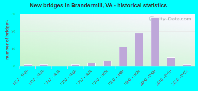
- New bridges - historical statistics
- 11920-1929
- 11930-1939
- 11950-1959
- 21960-1969
- 31970-1979
- 111980-1989
- 191990-1999
- 282000-2009
- 52010-2019
- 12020-2022

- Reconstructed bridges - Historical Statistics
- 11980-1989
- 31990-1999
- 22000-2009


- Bridge Condition - Deck
- 76.7%Good
- 20.0%Satisfactory
- 3.3%Fair

- Bridge Condition - Superstructure
- 20.0%Very good
- 53.3%Good
- 16.7%Satisfactory
- 10.0%Fair

- Bridge Condition - Substructure
- 3.3%Very good
- 46.7%Good
- 43.3%Satisfactory
- 6.7%Fair

- Bridge Condition - Channel
- 3.6%Very good
- 10.7%Good
- 28.6%Satisfactory
- 46.4%Fair
- 10.7%Poor

- Bridge Condition - Culverts
- 5.3%Very good
- 26.3%Good
- 52.6%Satisfactory
- 10.5%Fair
- 5.3%Poor
Find on map >> Show street view
Structure Number: 5012, Location: 0.26 FR 667 & 0.61 TO 707 (Lat: 37.507269, Lng: -77.673094), Route carried "on" structure: US 60, Year Built: 1938, Year Reconstructed: 2007, Status: Open, Structure Length: 5.21m (17.09ft), Average Daily Traffic: 16,870 (year 2020), Truck Traffic: 2%, Average Future Daily Traffic: 23,618 (year 2040), Design Load: HS 20+Mod, Features Intersected: NS RAILWAY, Facility Carried by Structure: MIDLOTHN TRNPK WBL
Minimum Vertical Clearance: 30+ m (98+ ft), Kilometerpoint: 282.941, Lanes on structure: 2, Base Highway Network: Yes, Owner: State Highway Agency, Approaching Roadway Width: 11.0m (36.1ft), Skew: 4 degrees, Material/Design: Steel continuous, Design/Construction: Stringer/Multi-beam, Number Of Spans In Main Unit: 3, Length of Maximum Span: 18.0m (59.1ft), Curb-To-Curb Width: 11.0m (36.1ft), Out-to-Out Width: 12.0m (39.4ft)
Condition: Deck: Good, Superstructure: Very good, Substructure: Satisfactory, Operating Rating: 89.8 metric tons, Method Used To Determine Operating Rating: Load and Resistance Factor (LRFR), Inventory Rating: 79.7 metric tons, Method Used To Determine Inventory Rating: Load and Resistance Factor (LRFR), Structural Evaluation: Equal to present minimum criteria, Deck Geometry: Equal to present minimum criteria, Underclear: Somewhat better than minimum adequacy, Approach Roadway Alignment: Equal to present desirable criteria, Designated Inspection Frequency: Every 24 months, Inspection Date: October 2021, Deck Structure Type: Concrete Cast-file-Place, Wearing Surface/Protective System: Deck Protection: Epoxy Coated Reinforcing
Find on map >> Show street view
Structure Number: 5017, Location: 0.26 FR 667 & 0.62 TO 707 (Lat: 37.507167, Lng: -77.673394), Route carried "on" structure: US 60, Year Built: 1969, Status: Open, Structure Length: 4.94m (16.21ft), Average Daily Traffic: 16,870 (year 2020), Truck Traffic: 2%, Average Future Daily Traffic: 23,618 (year 2040), Design Load: HS 20+Mod, Features Intersected: NS RAILWAY, Facility Carried by Structure: MIDLOTHIAN TPK EBL
Minimum Vertical Clearance: 30+ m (98+ ft), Kilometerpoint: 282.910, Lanes on structure: 2, Base Highway Network: Yes, Owner: State Highway Agency, Approaching Roadway Width: 11.9m (39.0ft), Skew: 4 degrees, Material/Design: Steel, Design/Construction: Stringer/Multi-beam, Number Of Spans In Main Unit: 3, Length of Maximum Span: 16.2m (53.1ft), Curb or Sidewalk Widths: Left: 0.2m (0.7ft), Right: 0.2m (0.7ft), Curb-To-Curb Width: 11.8m (38.7ft), Out-to-Out Width: 12.7m (41.7ft)
Condition: Deck: Fair, Superstructure: Fair, Substructure: Fair, Operating Rating: 89.8 metric tons, Method Used To Determine Operating Rating: Load and Resistance Factor (LRFR), Inventory Rating: 82.6 metric tons, Method Used To Determine Inventory Rating: Load and Resistance Factor (LRFR), Structural Evaluation: Somewhat better than minimum adequacy, Deck Geometry: Better than present minimum criteria, Underclear: Somewhat better than minimum adequacy, Approach Roadway Alignment: Equal to present desirable criteria, Designated Inspection Frequency: Every 24 months, Inspection Date: October 2021, Deck Structure Type: Concrete Cast-file-Place
Find on map >> Show street view
Structure Number: 5142, Location: 2.59 Fr 604 & 1.06 To 360 (Lat: 37.411475, Lng: -77.616386), Route carried "on" structure: State highway 288, Year Built: 1990, Status: Open, Structure Length: 4.31m (14.14ft), Average Daily Traffic: 19,974 (year 2020), Truck Traffic: 5%, Average Future Daily Traffic: 27,964 (year 2040), Design Load: HS 20+Mod, Features Intersected: ROUTE 654
Minimum Vertical Clearance: 30+ m (98+ ft), Kilometerpoint: 20.113, Lanes on structure: 2, Lanes under structure: 2, Base Highway Network: Yes, Owner: State Highway Agency, Approaching Roadway Width: 12.4m (40.7ft), Skew: 2 degrees, Material/Design: Steel, Design/Construction: Stringer/Multi-beam, Number Of Spans In Main Unit: 3, Length of Maximum Span: 15.8m (51.8ft), Curb-To-Curb Width: 12.4m (40.7ft), Out-to-Out Width: 13.4m (44.0ft)
Condition: Deck: Good, Superstructure: Good, Substructure: Satisfactory, Operating Rating: 63.5 metric tons, Method Used To Determine Operating Rating: Load and Resistance Factor (LRFR), Inventory Rating: 49.0 metric tons, Method Used To Determine Inventory Rating: Load and Resistance Factor (LRFR), Structural Evaluation: Equal to present minimum criteria, Deck Geometry: Better than present minimum criteria, Underclear: Meets minimum limits, Approach Roadway Alignment: Equal to present desirable criteria, Designated Inspection Frequency: Every 24 months, Inspection Date: April 2020, Deck Structure Type: Concrete Cast-file-Place, Wearing Surface/Protective System: Deck Protection: Epoxy Coated Reinforcing
Find on map >> Show street view
Structure Number: 5144, Location: 2.59 Fr 604 & 1.06 To 360 (Lat: 37.411331, Lng: -77.616692), Route carried "on" structure: State highway 288, Year Built: 1990, Status: Open, Structure Length: 4.93m (16.17ft), Average Daily Traffic: 19,974 (year 2020), Truck Traffic: 5%, Average Future Daily Traffic: 27,964 (year 2040), Design Load: HS 20+Mod, Features Intersected: ROUTE 654
Minimum Vertical Clearance: 30+ m (98+ ft), Kilometerpoint: 20.113, Lanes on structure: 2, Lanes under structure: 2, Base Highway Network: Yes, Owner: State Highway Agency, Approaching Roadway Width: 12.5m (41.0ft), Skew: 2 degrees, Material/Design: Steel, Design/Construction: Stringer/Multi-beam, Number Of Spans In Main Unit: 3, Length of Maximum Span: 15.8m (51.8ft), Curb-To-Curb Width: 12.4m (40.7ft), Out-to-Out Width: 13.4m (44.0ft)
Condition: Deck: Good, Superstructure: Good, Substructure: Satisfactory, Operating Rating: 63.5 metric tons, Method Used To Determine Operating Rating: Load and Resistance Factor (LRFR), Inventory Rating: 49.0 metric tons, Method Used To Determine Inventory Rating: Load and Resistance Factor (LRFR), Structural Evaluation: Equal to present minimum criteria, Deck Geometry: Better than present minimum criteria, Underclear: Meets minimum limits, Approach Roadway Alignment: Equal to present desirable criteria, Designated Inspection Frequency: Every 24 months, Inspection Date: April 2020, Deck Structure Type: Concrete Cast-file-Place, Wearing Surface/Protective System: Deck Protection: Epoxy Coated Reinforcing
Find on map >> Show street view
Structure Number: 5146, Location: 1.0 FR 360 & .30 TO 288 (Lat: 37.415736, Lng: -77.622700), Route carried "on" structure: Ramp State highway 288, Year Built: 1990, Status: Open, Structure Length: 10.67m (35.01ft), Average Daily Traffic: 200 (year 1990), Truck Traffic: 10%, Average Future Daily Traffic: 280 (year 2026), Design Load: HS 20+Mod, Features Intersected: RTE 288, Facility Carried by Structure: COM CTR PKY FLYOVR
Minimum Vertical Clearance: 30+ m (98+ ft), Kilometerpoint: 0.000, Lanes on structure: 1, Lanes under structure: 6, Owner: State Highway Agency, Approaching Roadway Width: 9.1m (29.9ft), Skew: 9 degrees, Material/Design: Steel continuous, Design/Construction: Stringer/Multi-beam, Number Of Spans In Main Unit: 2, Length of Maximum Span: 54.6m (179.1ft), Curb-To-Curb Width: 9.1m (29.9ft), Out-to-Out Width: 10.2m (33.5ft)
Condition: Deck: Good, Superstructure: Good, Substructure: Satisfactory, Operating Rating: 70.8 metric tons, Method Used To Determine Operating Rating: Load and Resistance Factor (LRFR), Inventory Rating: 54.4 metric tons, Method Used To Determine Inventory Rating: Load and Resistance Factor (LRFR), Structural Evaluation: Equal to present minimum criteria, Deck Geometry: Superior to present desirable criteria, Underclear: Equal to present minimum criteria, Approach Roadway Alignment: Equal to present desirable criteria, Designated Inspection Frequency: Every 24 months, Inspection Date: April 2020, Deck Structure Type: Concrete Cast-file-Place, Wearing Surface/Protective System: Deck Protection: Epoxy Coated Reinforcing
Find on map >> Show street view
Structure Number: 5157, Location: 1.80 Fr 604 & 2.10 To 360 (Lat: 37.410475, Lng: -77.597992), Route carried "on" structure: State highway 288, Year Built: 1990, Status: Open, Structure Length: 4.21m (13.81ft), Average Daily Traffic: 19,974 (year 2020), Truck Traffic: 5%, Average Future Daily Traffic: 27,964 (year 2040), Design Load: HS 20+Mod, Features Intersected: Unnamed Tributary
Minimum Vertical Clearance: 30+ m (98+ ft), Kilometerpoint: 18.504, Lanes on structure: 2, Base Highway Network: Yes, Owner: State Highway Agency, Approaching Roadway Width: 12.5m (41.0ft), Skew: 4 degrees, Material/Design: Concrete, Design/Construction: Culvert, Number Of Spans In Main Unit: 3, Length of Maximum Span: 3.0m (9.8ft)
Condition: Channel: Fair, Culverts: Satisfactory, Operating Rating: 54.4 metric tons, Method Used To Determine Operating Rating: Field evaluation and documented engineering judgment, Inventory Rating: 32.7 metric tons, Method Used To Determine Inventory Rating: Field evaluation and documented engineering judgment, Structural Evaluation: Equal to present minimum criteria, Waterway Adequacy: Equal to present desirable criteria, Approach Roadway Alignment: Equal to present desirable criteria, Designated Inspection Frequency: Every 24 months, Inspection Date: April 2020
Find on map >> Show street view
Structure Number: 5158, Location: 1.80 Fr 604 & 2.17 To 360 (Lat: 37.411017, Lng: -77.598536), Route carried "on" structure: State highway 288, Year Built: 1990, Status: Open, Structure Length: 3.11m (10.20ft), Average Daily Traffic: 19,974 (year 2020), Truck Traffic: 5%, Average Future Daily Traffic: 27,964 (year 2040), Design Load: HS 20+Mod, Features Intersected: Unnamed Tributary
Minimum Vertical Clearance: 30+ m (98+ ft), Kilometerpoint: 18.343, Lanes on structure: 2, Base Highway Network: Yes, Owner: State Highway Agency, Approaching Roadway Width: 12.5m (41.0ft), Material/Design: Concrete, Design/Construction: Culvert, Number Of Spans In Main Unit: 3, Length of Maximum Span: 3.0m (9.8ft)
Condition: Channel: Fair, Culverts: Satisfactory, Operating Rating: 54.4 metric tons, Method Used To Determine Operating Rating: Field evaluation and documented engineering judgment, Inventory Rating: 32.7 metric tons, Method Used To Determine Inventory Rating: Field evaluation and documented engineering judgment, Structural Evaluation: Equal to present minimum criteria, Waterway Adequacy: Equal to present desirable criteria, Approach Roadway Alignment: Equal to present desirable criteria, Designated Inspection Frequency: Every 24 months, Inspection Date: April 2020
Find on map >> Show street view
Structure Number: 5159, Location: 3.20 Fr 604 & 0.70 To 360 (Lat: 37.415678, Lng: -77.621531), Route carried "on" structure: State highway 288, Year Built: 1990, Status: Open, Structure Length: 2.87m (9.42ft), Average Daily Traffic: 39,948 (year 2020), Truck Traffic: 5%, Average Future Daily Traffic: 55,927 (year 2040), Design Load: HS 20+Mod, Features Intersected: Nuttree Branch
Minimum Vertical Clearance: 30+ m (98+ ft), Kilometerpoint: 20.756, Lanes on structure: 6, Base Highway Network: Yes, Owner: State Highway Agency, Approaching Roadway Width: 29.9m (98.1ft), Skew: 25 degrees, Material/Design: Concrete, Design/Construction: Culvert, Number Of Spans In Main Unit: 5, Length of Maximum Span: 5.2m (17.1ft)
Condition: Channel: Fair, Culverts: Satisfactory, Operating Rating: 89.8 metric tons, Method Used To Determine Operating Rating: Field evaluation and documented engineering judgment, Inventory Rating: 89.8 metric tons, Method Used To Determine Inventory Rating: Field evaluation and documented engineering judgment, Structural Evaluation: Equal to present minimum criteria, Waterway Adequacy: Equal to present desirable criteria, Approach Roadway Alignment: Equal to present desirable criteria, Designated Inspection Frequency: Every 24 months, Inspection Date: April 2020
Find on map >> Show street view
Structure Number: 5163, Location: 4.05 FR 604 & 2.34 TO 76 (Lat: 37.423508, Lng: -77.630117), Route carried "on" structure: State highway 288, Year Built: 1988, Status: Open, Structure Length: 6.33m (20.77ft), Average Daily Traffic: 25,652 (year 2020), Truck Traffic: 5%, Average Future Daily Traffic: 35,914 (year 2040), Design Load: HS 20+Mod, Features Intersected: ROUTE 360
Minimum Vertical Clearance: 30+ m (98+ ft), Kilometerpoint: 21.915, Lanes on structure: 3, Lanes under structure: 8, Base Highway Network: Yes, Owner: State Highway Agency, Approaching Roadway Width: 16.2m (53.1ft), Material/Design: Steel continuous, Design/Construction: Stringer/Multi-beam, Number Of Spans In Main Unit: 2, Length of Maximum Span: 31.2m (102.4ft), Curb-To-Curb Width: 16.1m (52.8ft), Out-to-Out Width: 17.1m (56.1ft)
Condition: Deck: Good, Superstructure: Fair, Substructure: Satisfactory, Operating Rating: 67.1 metric tons, Method Used To Determine Operating Rating: Load and Resistance Factor (LRFR), Inventory Rating: 51.7 metric tons, Method Used To Determine Inventory Rating: Load and Resistance Factor (LRFR), Structural Evaluation: Somewhat better than minimum adequacy, Deck Geometry: Equal to present minimum criteria, Underclear: Better than present minimum criteria, Approach Roadway Alignment: Equal to present desirable criteria, Length Of Structure Improvement: 6.34m (20.80ft), Designated Inspection Frequency: Every 24 months, Inspection Date: September 2021, Bridge Improvement Cost: $75,000, Roadway Improvement Cost: $5,000, Total Project Cost: $85,000, Deck Structure Type: Concrete Cast-file-Place, Wearing Surface/Protective System: Deck Protection: Epoxy Coated Reinforcing
Find on map >> Show street view
Structure Number: 5165, Location: 4.05 To 604 & 2.34 Fr 76 (Lat: 37.423422, Lng: -77.630400), Route carried "on" structure: State highway 288, Year Built: 1988, Status: Open, Structure Length: 6.33m (20.77ft), Average Daily Traffic: 25,652 (year 2020), Truck Traffic: 5%, Average Future Daily Traffic: 35,914 (year 2040), Design Load: HS 20+Mod, Features Intersected: ROUTE 360
Minimum Vertical Clearance: 30+ m (98+ ft), Kilometerpoint: 21.915, Lanes on structure: 3, Lanes under structure: 5, Base Highway Network: Yes, Owner: State Highway Agency, Approaching Roadway Width: 16.2m (53.1ft), Material/Design: Steel continuous, Design/Construction: Stringer/Multi-beam, Number Of Spans In Main Unit: 2, Length of Maximum Span: 31.2m (102.4ft), Curb-To-Curb Width: 16.1m (52.8ft), Out-to-Out Width: 17.1m (56.1ft)
Condition: Deck: Good, Superstructure: Satisfactory, Substructure: Satisfactory, Operating Rating: 57.2 metric tons, Method Used To Determine Operating Rating: Load and Resistance Factor (LRFR), Inventory Rating: 44.5 metric tons, Method Used To Determine Inventory Rating: Load and Resistance Factor (LRFR), Structural Evaluation: Equal to present minimum criteria, Deck Geometry: Equal to present minimum criteria, Underclear: Better than present minimum criteria, Approach Roadway Alignment: Equal to present desirable criteria, Designated Inspection Frequency: Every 24 months, Inspection Date: September 2021, Deck Structure Type: Concrete Cast-file-Place, Wearing Surface/Protective System: Deck Protection: Epoxy Coated Reinforcing
Find on map >> Show street view
Structure Number: 5167, Location: 2.66 Fr 360 & 0.85 To 720 (Lat: 37.461050, Lng: -77.638533), Route carried "on" structure: State highway 288, Year Built: 1988, Year Reconstructed: 2003, Status: Open, Structure Length: 6.77m (22.21ft), Average Daily Traffic: 25,652 (year 2020), Truck Traffic: 5%, Average Future Daily Traffic: 35,914 (year 2040), Design Load: HS 20+Mod, Features Intersected: ROUTE 76
Minimum Vertical Clearance: 30+ m (98+ ft), Kilometerpoint: 26.211, Lanes on structure: 5, Lanes under structure: 6, Base Highway Network: Yes, Owner: State Highway Agency, Approaching Roadway Width: 28.3m (92.8ft), Skew: 30 degrees, Material/Design: Steel continuous, Design/Construction: Stringer/Multi-beam, Number Of Spans In Main Unit: 2, Length of Maximum Span: 33.5m (109.9ft), Curb-To-Curb Width: 29.8m (97.8ft), Out-to-Out Width: 30.3m (99.4ft)
Condition: Deck: Good, Superstructure: Good, Substructure: Satisfactory, Operating Rating: 48.1 metric tons, Method Used To Determine Operating Rating: Load and Resistance Factor (LRFR), Inventory Rating: 37.2 metric tons, Method Used To Determine Inventory Rating: Load and Resistance Factor (LRFR), Structural Evaluation: Equal to present minimum criteria, Deck Geometry: Superior to present desirable criteria, Underclear: Somewhat better than minimum adequacy, Approach Roadway Alignment: Equal to present desirable criteria, Designated Inspection Frequency: Every 24 months, Inspection Date: September 2021, Deck Structure Type: Concrete Cast-file-Place, Wearing Surface/Protective System: Deck Protection: Epoxy Coated Reinforcing
Find on map >> Show street view
Structure Number: 5169, Location: 0.35 Fr 360 & 2.29 To 76 (Lat: 37.428431, Lng: -77.632439), Route carried "on" structure: State highway 288, Year Built: 1988, Status: Open, Structure Length: 1.28m (4.20ft), Average Daily Traffic: 51,305 (year 2020), Truck Traffic: 5%, Average Future Daily Traffic: 71,827 (year 2040), Design Load: HS 20+Mod, Features Intersected: NUTTREE BRANCH
Minimum Vertical Clearance: 30+ m (98+ ft), Kilometerpoint: 22.429, Lanes on structure: 5, Base Highway Network: Yes, Owner: State Highway Agency, Approaching Roadway Width: 28.7m (94.2ft), Skew: 24 degrees, Material/Design: Concrete, Design/Construction: Culvert, Number Of Spans In Main Unit: 3, Length of Maximum Span: 4.0m (13.1ft)
Condition: Channel: Fair, Culverts: Satisfactory, Operating Rating: 89.8 metric tons, Method Used To Determine Operating Rating: Field evaluation and documented engineering judgment, Inventory Rating: 89.8 metric tons, Method Used To Determine Inventory Rating: Field evaluation and documented engineering judgment, Structural Evaluation: Equal to present minimum criteria, Waterway Adequacy: Equal to present desirable criteria, Approach Roadway Alignment: Equal to present desirable criteria, Designated Inspection Frequency: Every 24 months, Inspection Date: August 2020
Find on map >> Show street view
Structure Number: 517, Location: 1.20 Fr 360 & 1.05 To 76 (Lat: 37.440636, Lng: -77.635650), Route carried "on" structure: State highway 288, Year Built: 1988, Status: Open, Structure Length: 1.01m (3.31ft), Average Daily Traffic: 51,305 (year 2020), Truck Traffic: 5%, Average Future Daily Traffic: 71,827 (year 2040), Design Load: HS 20+Mod, Features Intersected: TRIB. OF NUTTREE BRANCH
Minimum Vertical Clearance: 30+ m (98+ ft), Kilometerpoint: 23.926, Lanes on structure: 4, Base Highway Network: Yes, Owner: State Highway Agency, Approaching Roadway Width: 28.7m (94.2ft), Skew: 23 degrees, Material/Design: Concrete, Design/Construction: Culvert, Number Of Spans In Main Unit: 3, Length of Maximum Span: 3.0m (9.8ft)
Condition: Channel: Fair, Culverts: Satisfactory, Operating Rating: 89.8 metric tons, Method Used To Determine Operating Rating: Field evaluation and documented engineering judgment, Inventory Rating: 89.8 metric tons, Method Used To Determine Inventory Rating: Field evaluation and documented engineering judgment, Structural Evaluation: Equal to present minimum criteria, Waterway Adequacy: Equal to present desirable criteria, Approach Roadway Alignment: Equal to present desirable criteria, Designated Inspection Frequency: Every 24 months, Inspection Date: August 2020
Find on map >> Show street view
Structure Number: 5223, Location: .62 FR 690 & .62 TO 621 (Lat: 37.403358, Lng: -77.681533), Route carried "on" structure: US 360, Year Built: 1928, Year Reconstructed: 1985, Status: Open, Structure Length: 1.19m (3.90ft), Average Daily Traffic: 22,853 (year 2020), Truck Traffic: 7%, Average Future Daily Traffic: 31,994 (year 2040), Design Load: HS 20+Mod, Features Intersected: DRY CREEK, Facility Carried by Structure: HULL ST. ROAD WBL
Minimum Vertical Clearance: 30+ m (98+ ft), Kilometerpoint: 199.070, Lanes on structure: 3, Base Highway Network: Yes, Owner: State Highway Agency, Approaching Roadway Width: 13.1m (43.0ft), Skew: 4 degrees, Material/Design: Steel, Design/Construction: Stringer/Multi-beam, Number Of Spans In Main Unit: 1, Length of Maximum Span: 11.9m (39.0ft), Curb or Sidewalk Widths: Left: 0.2m (0.7ft), Right: 0.2m (0.7ft), Curb-To-Curb Width: 13.0m (42.7ft), Out-to-Out Width: 14.1m (46.3ft)
Condition: Deck: Good, Superstructure: Good, Substructure: Satisfactory, Channel: Good, Operating Rating: 44.5 metric tons, Method Used To Determine Operating Rating: Load and Resistance Factor (LRFR), Inventory Rating: 34.5 metric tons, Method Used To Determine Inventory Rating: Load and Resistance Factor (LRFR), Structural Evaluation: Equal to present minimum criteria, Deck Geometry: Meets minimum limits, Waterway Adequacy: Equal to present minimum criteria, Approach Roadway Alignment: Equal to present desirable criteria, Designated Inspection Frequency: Every 24 months, Underwater Inspection Frequency: Every 60 months, Inspection Date: June 2021, Underwater Inspection Date: June 2020, Deck Structure Type: Concrete Cast-file-Place, Wearing Surface/Protective System: Deck Protection: Epoxy Coated Reinforcing
Find on map >> Show street view
Structure Number: 5228, Location: 0.36 Fr 787 & 0.63 To 907 (Lat: 37.424939, Lng: -77.627625), Route carried "on" structure: US 360, Year Built: 1957, Status: Open, Structure Length: 1.07m (3.51ft), Average Daily Traffic: 41,201 (year 2020), Truck Traffic: 6%, Average Future Daily Traffic: 55,040 (year 2040), Design Load: HS 20, Features Intersected: NUTTREE BRANCH, Facility Carried by Structure: HULL STREET ROAD
Minimum Vertical Clearance: 30+ m (98+ ft), Kilometerpoint: 204.633, Lanes on structure: 6, Base Highway Network: Yes, Owner: State Highway Agency, Approaching Roadway Width: 18.3m (60.0ft), Skew: 22 degrees, Material/Design: Concrete, Design/Construction: Culvert, Number Of Spans In Main Unit: 3, Length of Maximum Span: 3.4m (11.2ft)
Condition: Channel: Fair, Culverts: Fair, Operating Rating: 64.9 metric tons, Method Used To Determine Operating Rating: Load and Resistance Factor (LRFR), Inventory Rating: 50.0 metric tons, Method Used To Determine Inventory Rating: Load and Resistance Factor (LRFR), Structural Evaluation: Somewhat better than minimum adequacy, Waterway Adequacy: Better than present minimum criteria, Approach Roadway Alignment: Equal to present desirable criteria, Designated Inspection Frequency: Every 24 months, Inspection Date: March 2021
Find on map >> Show street view
Structure Number: 5241, Location: 0.69 Fr 754 & 0.50 To 907 (Lat: 37.450311, Lng: -77.637589), Route carried "on" structure: County highway 604, Year Built: 1988, Year Reconstructed: 2004, Status: Open, Structure Length: 6.52m (21.39ft), Average Daily Traffic: 13,220 (year 2020), Truck Traffic: 1%, Average Future Daily Traffic: 18,508 (year 2040), Design Load: HS 20+Mod, Features Intersected: ROUTE 288, Facility Carried by Structure: GENITO ROAD
Minimum Vertical Clearance: 30+ m (98+ ft), Kilometerpoint: 14.627, Lanes on structure: 4, Lanes under structure: 6, Owner: State Highway Agency, Approaching Roadway Width: 17.4m (57.1ft), Skew: 20 degrees, Material/Design: Steel continuous, Design/Construction: Stringer/Multi-beam, Number Of Spans In Main Unit: 2, Length of Maximum Span: 32.0m (105.0ft), Curb or Sidewalk Widths: Left: 0.0m, Right: 2.3m (7.5ft), Curb-To-Curb Width: 17.2m (56.4ft), Out-to-Out Width: 25.2m (82.7ft)
Condition: Deck: Good, Superstructure: Good, Substructure: Satisfactory, Operating Rating: 59.0 metric tons, Method Used To Determine Operating Rating: Load and Resistance Factor (LRFR), Inventory Rating: 45.4 metric tons, Method Used To Determine Inventory Rating: Load and Resistance Factor (LRFR), Structural Evaluation: Equal to present minimum criteria, Deck Geometry: Somewhat better than minimum adequacy, Underclear: Equal to present minimum criteria, Approach Roadway Alignment: Equal to present desirable criteria, Designated Inspection Frequency: Every 24 months, Inspection Date: June 2020, Deck Structure Type: Concrete Cast-file-Place, Wearing Surface/Protective System: Deck Protection: Epoxy Coated Reinforcing
Find on map >> Show street view
Structure Number: 5287, Location: .81 FR 654 & .76 TO 653 (Lat: 37.409811, Lng: -77.603192), Route carried "on" structure: County highway 651, Year Built: 1990, Status: Open, Structure Length: 13.17m (43.21ft), Average Daily Traffic: 3,820 (year 2020), Truck Traffic: 1%, Average Future Daily Traffic: 5,166 (year 2040), Design Load: HS 20+Mod, Features Intersected: ROUTE 288
Minimum Vertical Clearance: 30+ m (98+ ft), Kilometerpoint: 3.107, Lanes on structure: 2, Lanes under structure: 4, Owner: State Highway Agency, Approaching Roadway Width: 8.8m (28.9ft), Skew: 3 degrees, Material/Design: Steel continuous, Design/Construction: Stringer/Multi-beam, Number Of Spans In Main Unit: 3, Number Of Approach Spans: 2, Length of Maximum Span: 39.6m (129.9ft), Curb-To-Curb Width: 8.7m (28.5ft), Out-to-Out Width: 9.8m (32.2ft)
Condition: Deck: Good, Superstructure: Good, Substructure: Good, Operating Rating: 79.8 metric tons, Method Used To Determine Operating Rating: Load and Resistance Factor (LRFR), Inventory Rating: 61.7 metric tons, Method Used To Determine Inventory Rating: Load and Resistance Factor (LRFR), Structural Evaluation: Better than present minimum criteria, Deck Geometry: Meets minimum limits, Underclear: Equal to present minimum criteria, Approach Roadway Alignment: Equal to present desirable criteria, Designated Inspection Frequency: Every 24 months, Inspection Date: April 2020, Deck Structure Type: Concrete Cast-file-Place, Wearing Surface/Protective System: Deck Protection: Epoxy Coated Reinforcing
Find on map >> Show street view
Structure Number: 5297, Location: 0.57 Fr 670 & 0.07 To 685 (Lat: 37.497183, Lng: -77.708517), Route carried "on" structure: County highway 652, Year Built: 1974, Status: Open, Structure Length: 3.57m (11.71ft), Average Daily Traffic: 5,377 (year 2020), Truck Traffic: 2%, Average Future Daily Traffic: 5,915 (year 2040), Design Load: HS 20+Mod, Features Intersected: NORTHFOLK SOUTHERN RR, Facility Carried by Structure: OLD HUNDRED ROAD
Minimum Vertical Clearance: 30+ m (98+ ft), Kilometerpoint: 6.626, Lanes on structure: 2, Owner: State Highway Agency, Approaching Roadway Width: 8.5m (27.9ft), Material/Design: Steel, Design/Construction: Stringer/Multi-beam, Number Of Spans In Main Unit: 3, Length of Maximum Span: 13.4m (44.0ft), Curb-To-Curb Width: 8.5m (27.9ft), Out-to-Out Width: 9.8m (32.2ft)
Condition: Deck: Satisfactory, Superstructure: Fair, Substructure: Good, Operating Rating: 62.6 metric tons, Method Used To Determine Operating Rating: Load and Resistance Factor (LRFR), Inventory Rating: 48.1 metric tons, Method Used To Determine Inventory Rating: Load and Resistance Factor (LRFR), Structural Evaluation: Somewhat better than minimum adequacy, Deck Geometry: High priority of replacement, Underclear: Somewhat better than minimum adequacy, Approach Roadway Alignment: Equal to present minimum criteria, Length Of Structure Improvement: 3.57m (11.71ft), Designated Inspection Frequency: Every 24 months, Inspection Date: April 2021, Bridge Improvement Cost: $800,000, Roadway Improvement Cost: $200,000, Total Project Cost: $1,050,000, Deck Structure Type: Concrete Cast-file-Place
Find on map >> Show street view
Structure Number: 5301, Location: .16 FR 651 & .9 TO 756 (Lat: 37.405167, Lng: -77.593233), Route carried "on" structure: County highway 653, Year Built: 1990, Status: Open, Structure Length: 2.51m (8.23ft), Average Daily Traffic: 5,292 (year 2020), Truck Traffic: 2%, Average Future Daily Traffic: 7,409 (year 2040), Design Load: HS 20+Mod, Features Intersected: TRIBUTARY 4 TO SWIFT CK, Facility Carried by Structure: QUALLA ROAD
Minimum Vertical Clearance: 30+ m (98+ ft), Kilometerpoint: 14.135, Lanes on structure: 2, Owner: State Highway Agency, Approaching Roadway Width: 12.2m (40.0ft), Material/Design: Steel, Design/Construction: Stringer/Multi-beam, Number Of Spans In Main Unit: 1, Length of Maximum Span: 23.9m (78.4ft), Curb-To-Curb Width: 12.2m (40.0ft), Out-to-Out Width: 13.2m (43.3ft)
Condition: Deck: Satisfactory, Superstructure: Good, Substructure: Satisfactory, Channel: Poor, Operating Rating: 77.8 metric tons, Method Used To Determine Operating Rating: Load and Resistance Factor (LRFR), Inventory Rating: 60.1 metric tons, Method Used To Determine Inventory Rating: Load and Resistance Factor (LRFR), Structural Evaluation: Equal to present minimum criteria, Deck Geometry: Somewhat better than minimum adequacy, Waterway Adequacy: Equal to present desirable criteria, Approach Roadway Alignment: Equal to present desirable criteria, Designated Inspection Frequency: Every 24 months, Inspection Date: April 2020, Deck Structure Type: Concrete Cast-file-Place, Wearing Surface/Protective System: Deck Protection: Epoxy Coated Reinforcing
Find on map >> Show street view
Structure Number: 5302, Location: 1.02 Fr 654 & 0.50 To 649 (Lat: 37.395322, Lng: -77.597061), Route carried "on" structure: County highway 653, Year Built: 1960, Year Reconstructed: 2013, Status: Open, Structure Length: 4.45m (14.60ft), Average Daily Traffic: 6,174 (year 2020), Truck Traffic: 2%, Average Future Daily Traffic: 7,260 (year 2040), Design Load: HS 20+Mod, Features Intersected: SWIFT CREEK, Facility Carried by Structure: QUALLA ROAD
Minimum Vertical Clearance: 30+ m (98+ ft), Kilometerpoint: 12.941, Lanes on structure: 2, Owner: State Highway Agency, Approaching Roadway Width: 9.1m (29.9ft), Material/Design: Prestressed concrete, Design/Construction: Slab, Number Of Spans In Main Unit: 3, Length of Maximum Span: 14.9m (48.9ft), Curb or Sidewalk Widths: Left: 0.5m (1.6ft), Right: 0.5m (1.6ft), Curb-To-Curb Width: 7.3m (24.0ft), Out-to-Out Width: 8.2m (26.9ft)
Condition: Deck: Good, Superstructure: Good, Substructure: Fair, Channel: Satisfactory, Operating Rating: 64.4 metric tons, Method Used To Determine Operating Rating: Load and Resistance Factor (LRFR), Inventory Rating: 49.0 metric tons, Method Used To Determine Inventory Rating: Load and Resistance Factor (LRFR), Structural Evaluation: Somewhat better than minimum adequacy, Deck Geometry: High priority of replacement, Waterway Adequacy: Equal to present desirable criteria, Approach Roadway Alignment: Equal to present desirable criteria, Length Of Structure Improvement: 4.45m (14.60ft), Designated Inspection Frequency: Every 24 months, Underwater Inspection Frequency: Every 24 months, Inspection Date: March 2021, Underwater Inspection Date: March 2021, Bridge Improvement Cost: $380,000, Roadway Improvement Cost: $60,000, Total Project Cost: $572,000, Deck Structure Type: Other, Wearing Surface/Protective System: Wearing Surface: Bituminous
Find on map >> Show street view
Structure Number: 5314, Location: .35 FR 652 & 2.45 TO 60 (Lat: 37.479669, Lng: -77.688547), Route carried "on" structure: County highway 667, Year Built: 1979, Status: Open, Structure Length: 0.67m (2.20ft), Average Daily Traffic: 2,824 (year 2020), Truck Traffic: 1%, Average Future Daily Traffic: 3,106 (year 2040), Design Load: H 20, Features Intersected: TOMAHAWK CREEK, Facility Carried by Structure: OTTERDALE ROAD
Minimum Vertical Clearance: 30+ m (98+ ft), Kilometerpoint: 12.759, Lanes on structure: 2, Owner: State Highway Agency, Approaching Roadway Width: 9.1m (29.9ft), Material/Design: Steel, Design/Construction: Culvert, Number Of Spans In Main Unit: 3, Length of Maximum Span: 1.8m (5.9ft)
Condition: Channel: Poor, Culverts: Poor, Operating Rating: 44.5 metric tons, Method Used To Determine Operating Rating: Field evaluation and documented engineering judgment, Inventory Rating: 32.7 metric tons, Method Used To Determine Inventory Rating: Field evaluation and documented engineering judgment, Structural Evaluation: Meets minimum limits, Waterway Adequacy: Equal to present minimum criteria, Approach Roadway Alignment: Equal to present minimum criteria, Designated Inspection Frequency: Every 12 months, Inspection Date: March 2021
Find on map >> Show street view
Structure Number: 5353, Location: .09 FR 1873 & .09 TO 1871 (Lat: 37.444319, Lng: -77.653836), Route carried "on" structure: County highway 1878, Year Built: 1978, Status: Open, Structure Length: 0.67m (2.20ft), Average Daily Traffic: 718 (year 2015), Average Future Daily Traffic: 806 (year 2040), Design Load: H 20, Features Intersected: NUTTREE BRANCH, Facility Carried by Structure: OVERCREEK LANE
Minimum Vertical Clearance: 30+ m (98+ ft), Kilometerpoint: 0.145, Lanes on structure: 2, Owner: State Highway Agency, Approaching Roadway Width: 8.8m (28.9ft), Material/Design: Steel, Design/Construction: Culvert, Number Of Spans In Main Unit: 2, Length of Maximum Span: 3.0m (9.8ft)
Condition: Channel: Satisfactory, Culverts: Satisfactory, Operating Rating: 44.5 metric tons, Method Used To Determine Operating Rating: Field evaluation and documented engineering judgment, Inventory Rating: 32.7 metric tons, Method Used To Determine Inventory Rating: Field evaluation and documented engineering judgment, Structural Evaluation: Equal to present minimum criteria, Waterway Adequacy: Equal to present desirable criteria, Approach Roadway Alignment: Equal to present minimum criteria, Designated Inspection Frequency: Every 24 months, Inspection Date: September 2021
Find on map >> Show street view
Structure Number: 23384, Location: .55 FR 1921 & 1.49 TO 667 (Lat: 37.461494, Lng: -77.668939), Route carried "on" structure: County highway 652, Year Built: 1991, Status: Open, Structure Length: 1.43m (4.69ft), Average Daily Traffic: 16,891 (year 2020), Truck Traffic: 1%, Average Future Daily Traffic: 23,647 (year 2040), Design Load: H 20, Features Intersected: UNNAMED TRIBUTARY, Facility Carried by Structure: OLD HUNDRED ROAD
Minimum Vertical Clearance: 30+ m (98+ ft), Kilometerpoint: 1.207, Lanes on structure: 2, Owner: State Highway Agency, Approaching Roadway Width: 25.9m (85.0ft), Skew: 4 degrees, Material/Design: Steel, Design/Construction: Culvert, Number Of Spans In Main Unit: 4, Length of Maximum Span: 2.7m (8.9ft)
Condition: Channel: Satisfactory, Culverts: Satisfactory, Operating Rating: 54.4 metric tons, Method Used To Determine Operating Rating: Field evaluation and documented engineering judgment, Inventory Rating: 32.7 metric tons, Method Used To Determine Inventory Rating: Field evaluation and documented engineering judgment, Structural Evaluation: Equal to present minimum criteria, Waterway Adequacy: Equal to present desirable criteria, Approach Roadway Alignment: Equal to present desirable criteria, Designated Inspection Frequency: Every 24 months, Inspection Date: January 2022
Find on map >> Show street view
Structure Number: 23386, Location: .69 Fr 1921 & 1.35 To 667 (Lat: 37.462186, Lng: -77.672703), Route carried "on" structure: County highway 652, Year Built: 1991, Status: Open, Structure Length: 1.28m (4.20ft), Average Daily Traffic: 16,891 (year 2020), Truck Traffic: 1%, Average Future Daily Traffic: 23,647 (year 2040), Design Load: HS 20+Mod, Features Intersected: LITTLE TOMAHAWK CREEK, Facility Carried by Structure: OLD HUNDRED ROAD
Minimum Vertical Clearance: 30+ m (98+ ft), Kilometerpoint: 1.432, Lanes on structure: 2, Owner: State Highway Agency, Approaching Roadway Width: 17.7m (58.1ft), Material/Design: Concrete, Design/Construction: Culvert, Number Of Spans In Main Unit: 4, Length of Maximum Span: 3.0m (9.8ft)
Condition: Channel: Fair, Culverts: Satisfactory, Operating Rating: 54.4 metric tons, Method Used To Determine Operating Rating: Field evaluation and documented engineering judgment, Inventory Rating: 32.7 metric tons, Method Used To Determine Inventory Rating: Field evaluation and documented engineering judgment, Structural Evaluation: Equal to present minimum criteria, Waterway Adequacy: Equal to present desirable criteria, Approach Roadway Alignment: Equal to present desirable criteria, Designated Inspection Frequency: Every 24 months, Inspection Date: January 2022
Find on map >> Show street view
Structure Number: 24145, Location: .10 Fr 4715 & .10 To 4706 (Lat: 37.403003, Lng: -77.647561), Route carried "on" structure: County highway 4713, Year Built: 1989, Status: Open, Structure Length: 1.07m (3.51ft), Average Daily Traffic: 1,559 (year 2016), Average Future Daily Traffic: 2,307 (year 2040), Design Load: HS 20, Features Intersected: SPRING RUN, Facility Carried by Structure: BUCK RUB DRIVE
Minimum Vertical Clearance: 30+ m (98+ ft), Kilometerpoint: 1.947, Lanes on structure: 2, Owner: State Highway Agency, Approaching Roadway Width: 14.3m (46.9ft), Material/Design: Aluminum, Iron, Design/Construction: Arch - Deck, Number Of Spans In Main Unit: 2, Length of Maximum Span: 4.9m (16.1ft), Curb-To-Curb Width: 14.3m (46.9ft), Out-to-Out Width: 14.9m (48.9ft)
Condition: Deck: Satisfactory, Superstructure: Satisfactory, Substructure: Satisfactory, Channel: Fair, Operating Rating: 45.4 metric tons, Method Used To Determine Operating Rating: Load and Resistance Factor (LRFR), Inventory Rating: 25.4 metric tons, Method Used To Determine Inventory Rating: Load and Resistance Factor (LRFR), Structural Evaluation: Equal to present minimum criteria, Deck Geometry: Superior to present desirable criteria, Waterway Adequacy: Equal to present minimum criteria, Approach Roadway Alignment: Equal to present minimum criteria, Designated Inspection Frequency: Every 24 months, Inspection Date: October 2020, Wearing Surface/Protective System: Wearing Surface: Bituminous
Find on map >> Show street view
Structure Number: 25289, Location: 1.62 Fr 655 & 0.50 To End (Lat: 37.384492, Lng: -77.580969), Route carried "on" structure: County highway 780, Year Built: 1998, Status: Open, Structure Length: 1.58m (5.18ft), Average Daily Traffic: 361 (year 2018), Average Future Daily Traffic: 401 (year 2040), Design Load: HS 20+Mod, Features Intersected: THIRD BRANCH, Facility Carried by Structure: STATE PARK ROAD
Minimum Vertical Clearance: 30+ m (98+ ft), Kilometerpoint: 15.720, Lanes on structure: 2, Owner: State Highway Agency, Approaching Roadway Width: 8.8m (28.9ft), Material/Design: Prestressed concrete, Design/Construction: Box Beam or Girders - Multiple, Number Of Spans In Main Unit: 1, Length of Maximum Span: 15.4m (50.5ft), Curb or Sidewalk Widths: Left: 0.2m (0.7ft), Right: 0.2m (0.7ft), Curb-To-Curb Width: 8.7m (28.5ft), Out-to-Out Width: 9.8m (32.2ft)
Condition: Deck: Satisfactory, Superstructure: Satisfactory, Substructure: Good, Channel: Satisfactory, Operating Rating: 77.1 metric tons, Method Used To Determine Operating Rating: Load and Resistance Factor (LRFR), Inventory Rating: 59.0 metric tons, Method Used To Determine Inventory Rating: Load and Resistance Factor (LRFR), Structural Evaluation: Equal to present minimum criteria, Deck Geometry: Equal to present minimum criteria, Waterway Adequacy: Better than present minimum criteria, Approach Roadway Alignment: Equal to present desirable criteria, Designated Inspection Frequency: Every 24 months, Inspection Date: November 2021, Deck Structure Type: Other, Wearing Surface/Protective System: Wearing Surface: Bituminous, Membrane: Epoxy, Deck Protection: Epoxy Coated Reinforcing
Find on map >> Show street view
Structure Number: 25395, Location: 0.58 FR 817 & 0.52 TO 768 (Lat: 37.410981, Lng: -77.618461), Route carried "on" structure: County highway 654, Year Built: 2013, Status: Open, Structure Length: 5.56m (18.24ft), Average Daily Traffic: 10,240 (year 2020), Truck Traffic: 2%, Average Future Daily Traffic: 14,112 (year 2040), Design Load: HS 20+Mod, Features Intersected: SWIFT CREEK, Facility Carried by Structure: BAILEY BRIDGE ROAD
Minimum Vertical Clearance: 30+ m (98+ ft), Kilometerpoint: 0.000, Lanes on structure: 2, Owner: State Highway Agency, Approaching Roadway Width: 17.7m (58.1ft), Material/Design: Steel, Design/Construction: Stringer/Multi-beam, Number Of Spans In Main Unit: 3, Length of Maximum Span: 21.1m (69.2ft), Curb or Sidewalk Widths: Left: 0.0m, Right: 1.8m (5.9ft), Curb-To-Curb Width: 19.7m (64.6ft), Out-to-Out Width: 20.2m (66.3ft)
Condition: Deck: Good, Superstructure: Very good, Substructure: Good, Channel: Satisfactory, Operating Rating: 83.5 metric tons, Method Used To Determine Operating Rating: Load and Resistance Factor (LRFR), Inventory Rating: 64.4 metric tons, Method Used To Determine Inventory Rating: Load and Resistance Factor (LRFR), Structural Evaluation: Better than present minimum criteria, Deck Geometry: Superior to present desirable criteria, Waterway Adequacy: Equal to present desirable criteria, Approach Roadway Alignment: Equal to present minimum criteria, Designated Inspection Frequency: Every 24 months, Inspection Date: June 2021, Deck Structure Type: Concrete Cast-file-Place, Wearing Surface/Protective System: Wearing Surface: Monolithic Concrete, Deck Protection: Epoxy Coated Reinforcing
Find on map >> Show street view
Structure Number: 25579, Location: 2.66 Fr 360 & 0.85 To 720 (Lat: 37.461053, Lng: -77.637958), Route carried "on" structure: Ramp State highway 288, Year Built: 2003, Status: Open, Structure Length: 6.78m (22.24ft), Average Daily Traffic: 25,500 (year 2020), Truck Traffic: 5%, Average Future Daily Traffic: 10,500 (year 2023), Design Load: HS 20+Mod, Features Intersected: ROUTE 76
Minimum Vertical Clearance: 30+ m (98+ ft), Kilometerpoint: 26.211, Lanes on structure: 3, Lanes under structure: 6, Base Highway Network: Yes, Owner: State Highway Agency, Approaching Roadway Width: 16.2m (53.1ft), Material/Design: Steel continuous, Design/Construction: Stringer/Multi-beam, Number Of Spans In Main Unit: 2, Length of Maximum Span: 34.6m (113.5ft), Curb-To-Curb Width: 16.2m (53.1ft), Out-to-Out Width: 17.2m (56.4ft)
Condition: Deck: Good, Superstructure: Good, Substructure: Good, Operating Rating: 65.0 metric tons, Method Used To Determine Operating Rating: Load and Resistance Factor (LRFR), Inventory Rating: 50.1 metric tons, Method Used To Determine Inventory Rating: Load and Resistance Factor (LRFR), Structural Evaluation: Better than present minimum criteria, Deck Geometry: Superior to present desirable criteria, Underclear: High priority of corrective action, Approach Roadway Alignment: Equal to present desirable criteria, Designated Inspection Frequency: Every 24 months, Inspection Date: September 2021, Deck Structure Type: Concrete Cast-file-Place, Wearing Surface/Protective System: Deck Protection: Epoxy Coated Reinforcing
Find on map >> Show street view
Structure Number: 2558, Location: .60 FR 754 & 0.85 TO 3750 (Lat: 37.468917, Lng: -77.647847), Route carried "on" structure: County highway 720, Year Built: 2002, Year Reconstructed: 2003, Status: Open, Structure Length: 8.29m (27.20ft), Average Daily Traffic: 789 (year 2020), Truck Traffic: 1%, Average Future Daily Traffic: 868 (year 2040), Design Load: HS 20+Mod, Features Intersected: RTE 288 & COLL DIST RDS, Facility Carried by Structure: LUCKS LANE
Minimum Vertical Clearance: 30+ m (98+ ft), Kilometerpoint: 0.965, Lanes on structure: 4, Lanes under structure: 16, Owner: State Highway Agency, Approaching Roadway Width: 19.8m (65.0ft), Skew: 22 degrees, Material/Design: Steel continuous, Design/Construction: Stringer/Multi-beam, Number Of Spans In Main Unit: 2, Length of Maximum Span: 44.5m (146.0ft), Curb or Sidewalk Widths: Left: 2.5m (8.2ft), Right: 2.5m (8.2ft), Curb-To-Curb Width: 24.6m (80.7ft), Out-to-Out Width: 30.4m (99.7ft)
Condition: Deck: Good, Superstructure: Good, Substructure: Good, Operating Rating: 52.6 metric tons, Method Used To Determine Operating Rating: Load and Resistance Factor (LRFR), Inventory Rating: 40.8 metric tons, Method Used To Determine Inventory Rating: Load and Resistance Factor (LRFR), Structural Evaluation: Better than present minimum criteria, Deck Geometry: Superior to present desirable criteria, Underclear: Meets minimum limits, Approach Roadway Alignment: Equal to present desirable criteria, Designated Inspection Frequency: Every 24 months, Inspection Date: September 2021, Deck Structure Type: Concrete Cast-file-Place, Wearing Surface/Protective System: Deck Protection: Epoxy Coated Reinforcing
Find on map >> Show street view
Structure Number: 26641, Location: 1.30 Fr 754 & 0.65 To 952 (Lat: 37.483250, Lng: -77.664464), Route carried "on" structure: County highway 950, Year Built: 2003, Status: Open, Structure Length: 7.90m (25.92ft), Average Daily Traffic: 6,000 (year 2019), Truck Traffic: 1%, Average Future Daily Traffic: 7,000 (year 2025), Design Load: HS 20+Mod, Features Intersected: ROUTE 288, Facility Carried by Structure: CHARTER COLONY PKY
Minimum Vertical Clearance: 30+ m (98+ ft), Kilometerpoint: 0.000, Lanes on structure: 2, Lanes under structure: 4, Owner: State Highway Agency, Approaching Roadway Width: 10.7m (35.1ft), Skew: 2 degrees, Material/Design: Steel continuous, Design/Construction: Stringer/Multi-beam, Number Of Spans In Main Unit: 2, Length of Maximum Span: 42.1m (138.1ft), Curb or Sidewalk Widths: Left: 0.0m, Right: 1.7m (5.6ft), Curb-To-Curb Width: 10.6m (34.8ft), Out-to-Out Width: 13.2m (43.3ft)
Condition: Deck: Good, Superstructure: Very good, Substructure: Good, Operating Rating: 50.8 metric tons, Method Used To Determine Operating Rating: Load and Resistance Factor (LRFR), Inventory Rating: 39.0 metric tons, Method Used To Determine Inventory Rating: Load and Resistance Factor (LRFR), Structural Evaluation: Better than present minimum criteria, Deck Geometry: Meets minimum limits, Underclear: Superior to present desirable criteria, Approach Roadway Alignment: Equal to present desirable criteria, Designated Inspection Frequency: Every 24 months, Inspection Date: November 2020, Deck Structure Type: Concrete Cast-file-Place, Wearing Surface/Protective System: Deck Protection: Epoxy Coated Reinforcing
Find on map >> Show street view
Structure Number: 26642, Location: 1.27 Fr 3840 & 0.49 To 60 (Lat: 37.502886, Lng: -77.686550), Route carried "on" structure: State highway 288, Year Built: 2003, Status: Open, Structure Length: 6.66m (21.85ft), Average Daily Traffic: 19,320 (year 2020), Truck Traffic: 4%, Average Future Daily Traffic: 27,049 (year 2040), Design Load: HS 20+Mod, Features Intersected: NORFOLK SOUTHERN RAILWAY
Minimum Vertical Clearance: 30+ m (98+ ft), Kilometerpoint: 33.049, Lanes on structure: 3, Base Highway Network: Yes, Owner: State Highway Agency, Approaching Roadway Width: 23.7m (77.8ft), Skew: 1 degrees, Material/Design: Steel continuous, Design/Construction: Stringer/Multi-beam, Number Of Spans In Main Unit: 2, Length of Maximum Span: 32.2m (105.6ft), Curb-To-Curb Width: 23.7m (77.8ft), Out-to-Out Width: 25.6m (84.0ft)
Condition: Deck: Good, Superstructure: Very good, Substructure: Good, Operating Rating: 62.1 metric tons, Method Used To Determine Operating Rating: Load and Resistance Factor (LRFR), Inventory Rating: 47.9 metric tons, Method Used To Determine Inventory Rating: Load and Resistance Factor (LRFR), Structural Evaluation: Better than present minimum criteria, Deck Geometry: Superior to present desirable criteria, Underclear: Somewhat better than minimum adequacy, Approach Roadway Alignment: Equal to present desirable criteria, Designated Inspection Frequency: Every 24 months, Inspection Date: November 2020, Deck Structure Type: Concrete Cast-file-Place, Wearing Surface/Protective System: Deck Protection: Epoxy Coated Reinforcing
Find on map >> Show street view
Structure Number: 26644, Location: 1.27 Fr 3840 & 0.49 To 60 (Lat: 37.502794, Lng: -77.686869), Route carried "on" structure: State highway 288, Year Built: 2003, Status: Open, Structure Length: 6.66m (21.85ft), Average Daily Traffic: 19,320 (year 2020), Truck Traffic: 4%, Average Future Daily Traffic: 27,049 (year 2040), Design Load: HS 20+Mod, Features Intersected: NORFOLK SOUTHERN RAILWAY
Minimum Vertical Clearance: 30+ m (98+ ft), Kilometerpoint: 33.049, Lanes on structure: 4, Base Highway Network: Yes, Owner: State Highway Agency, Approaching Roadway Width: 27.4m (89.9ft), Skew: 31 degrees, Material/Design: Steel continuous, Design/Construction: Stringer/Multi-beam, Number Of Spans In Main Unit: 2, Length of Maximum Span: 32.2m (105.6ft), Curb-To-Curb Width: 27.0m (88.6ft), Out-to-Out Width: 28.6m (93.8ft)
Condition: Deck: Good, Superstructure: Very good, Substructure: Good, Operating Rating: 61.6 metric tons, Method Used To Determine Operating Rating: Load and Resistance Factor (LRFR), Inventory Rating: 47.5 metric tons, Method Used To Determine Inventory Rating: Load and Resistance Factor (LRFR), Structural Evaluation: Better than present minimum criteria, Deck Geometry: Superior to present desirable criteria, Underclear: Somewhat better than minimum adequacy, Approach Roadway Alignment: Equal to present desirable criteria, Designated Inspection Frequency: Every 24 months, Inspection Date: November 2020, Deck Structure Type: Concrete Cast-file-Place, Wearing Surface/Protective System: Deck Protection: Epoxy Coated Reinforcing
Find on map >> Show street view
Structure Number: 26645, Location: 0.40 FR 667 & 0.41 TO 971 (Lat: 37.509731, Lng: -77.687567), Route carried "on" structure: State highway 60, Year Built: 2003, Status: Open, Structure Length: 8.56m (28.08ft), Average Daily Traffic: 17,435 (year 2020), Truck Traffic: 1%, Average Future Daily Traffic: 24,409 (year 2040), Design Load: HS 20+Mod, Features Intersected: RTE 288 & COLL DIST RDS, Facility Carried by Structure: EBL MIDLOTHIAN TPK
Minimum Vertical Clearance: 30+ m (98+ ft), Kilometerpoint: 281.655, Lanes on structure: 4, Lanes under structure: 9, Base Highway Network: Yes, Owner: State Highway Agency, Approaching Roadway Width: 20.7m (67.9ft), Material/Design: Steel continuous, Design/Construction: Stringer/Multi-beam, Number Of Spans In Main Unit: 2, Length of Maximum Span: 42.1m (138.1ft), Curb-To-Curb Width: 19.8m (65.0ft), Out-to-Out Width: 20.8m (68.2ft)
Condition: Deck: Good, Superstructure: Good, Substructure: Good, Operating Rating: 56.2 metric tons, Method Used To Determine Operating Rating: Load and Resistance Factor (LRFR), Inventory Rating: 42.6 metric tons, Method Used To Determine Inventory Rating: Load and Resistance Factor (LRFR), Structural Evaluation: Better than present minimum criteria, Deck Geometry: Better than present minimum criteria, Underclear: High priority of corrective action, Approach Roadway Alignment: Equal to present desirable criteria, Designated Inspection Frequency: Every 24 months, Inspection Date: January 2021, Deck Structure Type: Concrete Cast-file-Place, Wearing Surface/Protective System: Deck Protection: Epoxy Coated Reinforcing
Find on map >> Show street view
Structure Number: 26646, Location: 0.40 FR 667 & 0.41 TO 971 (Lat: 37.509969, Lng: -77.687575), Route carried "on" structure: US 60, Year Built: 2003, Status: Open, Structure Length: 8.56m (28.08ft), Average Daily Traffic: 17,435 (year 2020), Truck Traffic: 1%, Average Future Daily Traffic: 24,409 (year 2040), Design Load: HS 20+Mod, Features Intersected: RTE 288 & COLL DIST RDS, Facility Carried by Structure: WBL MIDLOTHIAN TPK
Minimum Vertical Clearance: 30+ m (98+ ft), Kilometerpoint: 281.655, Lanes on structure: 3, Lanes under structure: 9, Base Highway Network: Yes, Owner: State Highway Agency, Approaching Roadway Width: 15.5m (50.9ft), Material/Design: Steel continuous, Design/Construction: Stringer/Multi-beam, Number Of Spans In Main Unit: 2, Length of Maximum Span: 42.1m (138.1ft), Curb-To-Curb Width: 15.6m (51.2ft), Out-to-Out Width: 16.6m (54.5ft)
Condition: Deck: Good, Superstructure: Good, Substructure: Good, Operating Rating: 68.0 metric tons, Method Used To Determine Operating Rating: Load and Resistance Factor (LRFR), Inventory Rating: 52.6 metric tons, Method Used To Determine Inventory Rating: Load and Resistance Factor (LRFR), Structural Evaluation: Better than present minimum criteria, Deck Geometry: Equal to present minimum criteria, Underclear: Somewhat better than minimum adequacy, Approach Roadway Alignment: Equal to present desirable criteria, Designated Inspection Frequency: Every 24 months, Inspection Date: January 2021, Deck Structure Type: Concrete Cast-file-Place, Wearing Surface/Protective System: Deck Protection: Epoxy Coated Reinforcing
Find on map >> Show street view
Structure Number: 26647, Location: 2.02 Fr 652 & 0.78 To 60 (Lat: 37.501225, Lng: -77.693267), Route carried "on" structure: County highway 667, Year Built: 2003, Status: Open, Structure Length: 5.58m (18.31ft), Average Daily Traffic: 2,800 (year 2019), Truck Traffic: 2%, Average Future Daily Traffic: 1,650 (year 2025), Design Load: HS 20+Mod, Features Intersected: NORFOLK SOUTHERN RAILWAY, Facility Carried by Structure: WATKINS CNTR PRKWY
Minimum Vertical Clearance: 30+ m (98+ ft), Kilometerpoint: 0.000, Lanes on structure: 2, Owner: State Highway Agency, Approaching Roadway Width: 11.9m (39.0ft), Skew: 2 degrees, Material/Design: Steel continuous, Design/Construction: Stringer/Multi-beam, Number Of Spans In Main Unit: 3, Length of Maximum Span: 19.5m (64.0ft), Curb-To-Curb Width: 12.0m (39.4ft), Out-to-Out Width: 13.0m (42.7ft)
Condition: Deck: Good, Superstructure: Good, Substructure: Good, Operating Rating: 88.9 metric tons, Method Used To Determine Operating Rating: Load and Resistance Factor (LRFR), Inventory Rating: 68.9 metric tons, Method Used To Determine Inventory Rating: Load and Resistance Factor (LRFR), Structural Evaluation: Better than present minimum criteria, Deck Geometry: Somewhat better than minimum adequacy, Underclear: Superior to present desirable criteria, Approach Roadway Alignment: Equal to present desirable criteria, Designated Inspection Frequency: Every 24 months, Inspection Date: September 2020, Deck Structure Type: Concrete Cast-file-Place, Wearing Surface/Protective System: Deck Protection: Epoxy Coated Reinforcing
Find on map >> Show street view
Structure Number: 26648, Location: 1.81 FR 720 & .22 TO 3840 (Lat: 37.487236, Lng: -77.669803), Route carried "on" structure: State highway 288, Year Built: 2003, Status: Open, Structure Length: 0.91m (2.99ft), Average Daily Traffic: 42,029 (year 2020), Truck Traffic: 5%, Average Future Daily Traffic: 58,841 (year 2040), Design Load: HS 20+Mod, Features Intersected: LITTLE TOMAHAWK CREEK
Minimum Vertical Clearance: 30+ m (98+ ft), Kilometerpoint: 0.000, Lanes on structure: 6, Base Highway Network: Yes, Owner: State Highway Agency, Approaching Roadway Width: 37.2m (122.0ft), Skew: 11 degrees, Material/Design: Concrete, Design/Construction: Culvert, Number Of Spans In Main Unit: 4, Length of Maximum Span: 2.1m (6.9ft)
Condition: Channel: Fair, Culverts: Satisfactory, Operating Rating: 89.8 metric tons, Method Used To Determine Operating Rating: Field evaluation and documented engineering judgment, Inventory Rating: 89.8 metric tons, Method Used To Determine Inventory Rating: Field evaluation and documented engineering judgment, Structural Evaluation: Equal to present minimum criteria, Waterway Adequacy: Equal to present desirable criteria, Approach Roadway Alignment: Equal to present desirable criteria, Designated Inspection Frequency: Every 24 months, Inspection Date: March 2021
Find on map >> Show street view
Structure Number: 26702, Location: 2.66 Fr 360 & 0.85 To 720 (Lat: 37.461111, Lng: -77.638167), Route carried "on" structure: State highway 288, Year Built: 2003, Status: Open, Structure Length: 6.78m (22.24ft), Average Daily Traffic: 25,652 (year 2020), Truck Traffic: 5%, Average Future Daily Traffic: 35,914 (year 2040), Design Load: HS 20+Mod, Features Intersected: ROUTE 76
Minimum Vertical Clearance: 30+ m (98+ ft), Kilometerpoint: 26.211, Lanes on structure: 2, Lanes under structure: 6, Base Highway Network: Yes, Owner: State Highway Agency, Approaching Roadway Width: 11.9m (39.0ft), Material/Design: Steel continuous, Design/Construction: Stringer/Multi-beam, Number Of Spans In Main Unit: 2, Length of Maximum Span: 34.6m (113.5ft), Curb-To-Curb Width: 12.0m (39.4ft), Out-to-Out Width: 13.2m (43.3ft)
Condition: Deck: Good, Superstructure: Good, Substructure: Good, Inventory Rating: 75.8 metric tons, Method Used To Determine Inventory Rating: Load and Resistance Factor (LRFR), Structural Evaluation: Better than present minimum criteria, Deck Geometry: Equal to present minimum criteria, Underclear: High priority of corrective action, Approach Roadway Alignment: Equal to present desirable criteria, Designated Inspection Frequency: Every 24 months, Inspection Date: September 2021, Deck Structure Type: Concrete Cast-file-Place, Wearing Surface/Protective System: Deck Protection: Epoxy Coated Reinforcing
Find on map >> Show street view
Structure Number: 26792, Location: 1.31 Fr 702 & 0.59 To 754 (Lat: 37.414197, Lng: -77.643958), Route carried "on" structure: US 360, Year Built: 2002, Status: Open, Structure Length: 5.18m (16.99ft), Average Daily Traffic: 33,924 (year 2020), Truck Traffic: 7%, Average Future Daily Traffic: 47,494 (year 2040), Design Load: HS 20+Mod, Features Intersected: SWIFT CREEK, Facility Carried by Structure: HULL SREET RD EBL
Minimum Vertical Clearance: 30+ m (98+ ft), Kilometerpoint: 202.702, Lanes on structure: 4, Base Highway Network: Yes, Owner: State Highway Agency, Approaching Roadway Width: 18.3m (60.0ft), Material/Design: Steel continuous, Design/Construction: Stringer/Multi-beam, Number Of Spans In Main Unit: 3, Length of Maximum Span: 21.3m (69.9ft), Curb or Sidewalk Widths: Left: 0.0m, Right: 2.0m (6.6ft), Curb-To-Curb Width: 20.3m (66.6ft), Out-to-Out Width: 21.2m (69.6ft)
Condition: Deck: Good, Superstructure: Good, Substructure: Good, Channel: Good, Operating Rating: 70.8 metric tons, Method Used To Determine Operating Rating: Load and Resistance Factor (LRFR), Inventory Rating: 54.4 metric tons, Method Used To Determine Inventory Rating: Load and Resistance Factor (LRFR), Structural Evaluation: Better than present minimum criteria, Deck Geometry: Equal to present desirable criteria, Waterway Adequacy: Equal to present desirable criteria, Approach Roadway Alignment: Equal to present desirable criteria, Designated Inspection Frequency: Every 24 months, Inspection Date: Febuary 2021, Deck Structure Type: Concrete Cast-file-Place, Wearing Surface/Protective System: Deck Protection: Epoxy Coated Reinforcing
Find on map >> Show street view
Structure Number: 27381, Location: 0.20 FR 653 & 1.48 TO 604 (Lat: 37.401550, Lng: -77.591011), Route carried "on" structure: County highway 651, Year Built: 2007, Status: Open, Structure Length: 1.46m (4.79ft), Average Daily Traffic: 3,592 (year 2020), Average Future Daily Traffic: 4,494 (year 2040), Design Load: HS 20+Mod, Features Intersected: N FORK SWIFT CREEK, Facility Carried by Structure: NEWBYS BRIDGE ROAD
Minimum Vertical Clearance: 30+ m (98+ ft), Kilometerpoint: 0.000, Lanes on structure: 2, Owner: State Highway Agency, Approaching Roadway Width: 11.9m (39.0ft), Skew: 3 degrees, Material/Design: Concrete, Design/Construction: Culvert, Number Of Spans In Main Unit: 4, Length of Maximum Span: 3.7m (12.1ft)
Condition: Channel: Fair, Culverts: Good, Operating Rating: 54.4 metric tons, Method Used To Determine Operating Rating: Field evaluation and documented engineering judgment, Inventory Rating: 32.7 metric tons, Method Used To Determine Inventory Rating: Field evaluation and documented engineering judgment, Structural Evaluation: Better than present minimum criteria, Waterway Adequacy: Superior to present desirable criteria, Approach Roadway Alignment: Equal to present desirable criteria, Designated Inspection Frequency: Every 24 months, Inspection Date: November 2021
Find on map >> Show street view
Structure Number: 27934, Location: 0.04Fr D.end &1.00 To 950 (Lat: 37.488508, Lng: -77.673828), Route carried "on" structure: County highway 3840, Year Built: 2003, Status: Open, Structure Length: 7.58m (24.87ft), Average Daily Traffic: 19,000 (year 2019), Average Future Daily Traffic: 2,800 (year 2025), Design Load: HS 20+Mod, Features Intersected: ROUTE 288, Facility Carried by Structure: WOOLRIDGE ROAD
Minimum Vertical Clearance: 30+ m (98+ ft), Kilometerpoint: 0.000, Lanes on structure: 4, Lanes under structure: 4, Owner: State Highway Agency, Approaching Roadway Width: 16.2m (53.1ft), Skew: 20 degrees, Material/Design: Prestressed concrete continuous, Design/Construction: Stringer/Multi-beam, Number Of Spans In Main Unit: 2, Length of Maximum Span: 37.3m (122.4ft), Curb or Sidewalk Widths: Left: 1.6m (5.2ft), Right: 1.6m (5.2ft), Curb-To-Curb Width: 16.2m (53.1ft), Out-to-Out Width: 25.1m (82.3ft)
Condition: Deck: Satisfactory, Superstructure: Satisfactory, Substructure: Satisfactory, Operating Rating: 77.5 metric tons, Method Used To Determine Operating Rating: Load and Resistance Factor (LRFR), Inventory Rating: 59.8 metric tons, Method Used To Determine Inventory Rating: Load and Resistance Factor (LRFR), Structural Evaluation: Equal to present minimum criteria, Deck Geometry: Meets minimum limits, Underclear: Equal to present minimum criteria, Approach Roadway Alignment: Equal to present desirable criteria, Designated Inspection Frequency: Every 24 months, Inspection Date: November 2020, Deck Structure Type: Concrete Cast-file-Place, Wearing Surface/Protective System: Deck Protection: Epoxy Coated Reinforcing
Find on map >> Show street view
Structure Number: 27935, Location: 1.19 Fr 360 & 1.16 To 604 (Lat: 37.433833, Lng: -77.642875), Route carried "on" structure: County highway 754, Year Built: 2004, Status: Open, Structure Length: 0.67m (2.20ft), Average Daily Traffic: 8,567 (year 2020), Truck Traffic: 2%, Average Future Daily Traffic: 11,994 (year 2040), Design Load: H 20, Features Intersected: NUTTREE BRANCH, Facility Carried by Structure: OLD HUNDRED ROAD
Minimum Vertical Clearance: 30+ m (98+ ft), Kilometerpoint: 2.214, Lanes on structure: 2, Owner: State Highway Agency, Approaching Roadway Width: 7.3m (24.0ft), Material/Design: Steel, Design/Construction: Culvert, Number Of Spans In Main Unit: 3, Length of Maximum Span: 1.8m (5.9ft)
Condition: Channel: Poor, Culverts: Fair, Operating Rating: 44.5 metric tons, Method Used To Determine Operating Rating: Field evaluation and documented engineering judgment, Inventory Rating: 32.7 metric tons, Method Used To Determine Inventory Rating: Field evaluation and documented engineering judgment, Structural Evaluation: Somewhat better than minimum adequacy, Waterway Adequacy: Equal to present minimum criteria, Approach Roadway Alignment: Better than present minimum criteria, Designated Inspection Frequency: Every 24 months, Inspection Date: August 2020
Find on map >> Show street view
Structure Number: 28314, Location: 0.8 FRM 604 & 0.7 TO 5589 (Lat: 37.450517, Lng: -77.679744), Route carried "on" structure: County highway 5583, Year Built: 2003, Status: Open, Structure Length: 2.71m (8.89ft), Average Daily Traffic: 2,322 (year 2012), Average Future Daily Traffic: 2,647 (year 2040), Design Load: HS 20, Features Intersected: TOMAHAWK CREEK, Facility Carried by Structure: WATERMILL PARKWAY
Minimum Vertical Clearance: 30+ m (98+ ft), Kilometerpoint: 1.287, Lanes on structure: 2, Owner: State Highway Agency, Approaching Roadway Width: 9.4m (30.8ft), Material/Design: Concrete, Design/Construction: Frame, Number Of Spans In Main Unit: 2, Length of Maximum Span: 12.8m (42.0ft), Curb-To-Curb Width: 9.4m (30.8ft), Out-to-Out Width: 22.4m (73.5ft)
Condition: Deck: Satisfactory, Superstructure: Satisfactory, Substructure: Satisfactory, Channel: Satisfactory, Operating Rating: 89.8 metric tons, Method Used To Determine Operating Rating: Load Factor (LF), Inventory Rating: 79.9 metric tons, Method Used To Determine Inventory Rating: Load Factor (LF), Structural Evaluation: Equal to present minimum criteria, Deck Geometry: Meets minimum limits, Waterway Adequacy: Superior to present desirable criteria, Approach Roadway Alignment: Equal to present desirable criteria, Designated Inspection Frequency: Every 24 months, Inspection Date: April 2020
Find on map >> Show street view
Structure Number: 28716, Location: 0.25 FR 653 & 1.43 TO 604 (Lat: 37.401583, Lng: -77.590436), Route carried "on" structure: County highway 651, Year Built: 2007, Status: Open, Structure Length: 0.67m (2.20ft), Average Daily Traffic: 3,592 (year 2020), Average Future Daily Traffic: 4,494 (year 2040), Design Load: HS 20+Mod, Features Intersected: N BRANCH OF SWIFT CREEK, Facility Carried by Structure: NEWBYS BRIDGE ROAD
Minimum Vertical Clearance: 30+ m (98+ ft), Kilometerpoint: 0.000, Lanes on structure: 2, Owner: State Highway Agency, Approaching Roadway Width: 11.9m (39.0ft), Skew: 2 degrees, Material/Design: Concrete, Design/Construction: Culvert, Number Of Spans In Main Unit: 2, Length of Maximum Span: 3.0m (9.8ft)
Condition: Channel: Satisfactory, Culverts: Good, Operating Rating: 54.4 metric tons, Method Used To Determine Operating Rating: Field evaluation and documented engineering judgment, Inventory Rating: 32.7 metric tons, Method Used To Determine Inventory Rating: Field evaluation and documented engineering judgment, Structural Evaluation: Better than present minimum criteria, Waterway Adequacy: Equal to present desirable criteria, Approach Roadway Alignment: Equal to present desirable criteria, Designated Inspection Frequency: Every 24 months, Inspection Date: November 2021