Bridge Statistics for Boise, Idaho (ID)
Condition, Traffic, Stress, Structural Evaluation, Project Costs
- National Bridge Inventory (NBI) Statistics
- 163Number of bridges
- 2,018ft / 615mTotal length
- $65,588,000Total costs
- 3,560,861Total average daily traffic
- 216,662Total average daily truck traffic
- National Bridge Inventory (NBI) Registered Bridges for Boise
- No street view available for this location
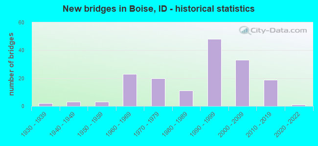
- New bridges - historical statistics
- 21930-1939
- 31940-1949
- 31950-1959
- 231960-1969
- 201970-1979
- 111980-1989
- 481990-1999
- 332000-2009
- 192010-2019
- 12020-2022

- Reconstructed bridges - Historical Statistics
- 21970-1979
- 41980-1989
- 51990-1999
- 42000-2009
- 22010-2019


- Bridge Condition - Deck
- 9.9%Very good
- 41.3%Good
- 45.5%Satisfactory
- 3.3%Fair

- Bridge Condition - Superstructure
- 24.0%Very good
- 36.4%Good
- 34.7%Satisfactory
- 5.0%Fair

- Bridge Condition - Substructure
- 14.9%Very good
- 46.3%Good
- 33.1%Satisfactory
- 5.8%Fair

- Bridge Condition - Channel
- 18.0%Excellent
- 48.0%Very good
- 21.0%Good
- 12.0%Satisfactory
- 1.0%Poor

- Bridge Condition - Culverts
- 33.3%Very good
- 22.2%Good
- 33.3%Satisfactory
- 11.1%Fair
Find on map >> Show street view
Structure Number: 12263, Location: IN BOISE;BOISE CONNECTOR (Lat: 43.618389, Lng: -116.229000), Route carried "on" structure: US 20, Year Built: 1990, Status: Open, Structure Length: 18.20m (59.71ft), Average Daily Traffic: 40,500 (year 2019), Truck Traffic: 3%, Average Future Daily Traffic: 60,750 (year 2039), Design Load: HS 25 or greater, Features Intersected: BOISE RIVER
Minimum Vertical Clearance: 30+ m (98+ ft), Kilometerpoint: 76.556, Lanes on structure: 7, Base Highway Network: Yes (Inventory Route: US0, Subroute: 3), Owner: State Highway Agency, Approaching Roadway Width: 36.6m (120.1ft), Skew: 32 degrees, Material/Design: Prestressed concrete continuous, Design/Construction: Box Beam or Girders - Multiple, Number Of Spans In Main Unit: 4, Length of Maximum Span: 49.4m (162.1ft), Curb-To-Curb Width: 35.6m (116.8ft), Out-to-Out Width: 37.5m (123.0ft)
Condition: Deck: Satisfactory, Superstructure: Satisfactory, Substructure: Satisfactory, Channel: Satisfactory, Operating Rating: 49.0 metric tons, Method Used To Determine Operating Rating: Load and Resistance Factor (LRFR), Inventory Rating: 27.2 metric tons, Method Used To Determine Inventory Rating: Load and Resistance Factor (LRFR), Structural Evaluation: Equal to present minimum criteria, Deck Geometry: Superior to present desirable criteria, Waterway Adequacy: Superior to present desirable criteria, Approach Roadway Alignment: Equal to present desirable criteria, Designated Inspection Frequency: Every 48 months, Underwater Inspection Frequency: Every 60 months, Inspection Date: Febuary 2021, Underwater Inspection Date: October 2017, Deck Structure Type: Concrete Cast-file-Place, Wearing Surface/Protective System: Wearing Surface: Latex Concrete, Deck Protection: Epoxy Coated Reinforcing
Find on map >> Show street view
Structure Number: 12264, Location: IN BOISE;BOISE CONNECTOR (Lat: 43.619067, Lng: -116.224011), Route carried "on" structure: US 20, Year Built: 1990, Status: Open, Structure Length: 2.65m (8.69ft), Average Daily Traffic: 40,500 (year 2019), Truck Traffic: 3%, Average Future Daily Traffic: 60,750 (year 2039), Design Load: HS 25 or greater, Features Intersected: SMA 9083;27TH STREET
Minimum Vertical Clearance: 30+ m (98+ ft), Kilometerpoint: 76.959, Lanes on structure: 6, Lanes under structure: 4, Base Highway Network: Yes (Inventory Route: US0, Subroute: 3), Owner: State Highway Agency, Approaching Roadway Width: 32.3m (106.0ft), Skew: 30 degrees, Material/Design: Prestressed concrete, Design/Construction: Stringer/Multi-beam, Number Of Spans In Main Unit: 1, Length of Maximum Span: 25.6m (84.0ft), Curb-To-Curb Width: 32.3m (106.0ft), Out-to-Out Width: 33.8m (110.9ft)
Condition: Deck: Satisfactory, Superstructure: Very good, Substructure: Very good, Operating Rating: 78.0 metric tons, Method Used To Determine Operating Rating: Load Factor (LF), Inventory Rating: 46.3 metric tons, Method Used To Determine Inventory Rating: Load Factor (LF), Structural Evaluation: Equal to present desirable criteria, Deck Geometry: Superior to present desirable criteria, Underclear: Meets minimum limits, Approach Roadway Alignment: Equal to present desirable criteria, Designated Inspection Frequency: Every 48 months, Inspection Date: April 2021, Deck Structure Type: Concrete Cast-file-Place, Wearing Surface/Protective System: Wearing Surface: Epoxy Overlay, Deck Protection: Epoxy Coated Reinforcing
Find on map >> Show street view
Structure Number: 12271, Location: IN BOISE; BROADWAY AVE (Lat: 43.603222, Lng: -116.193472), Route carried "on" structure: US 20, Year Built: 2016, Status: Open, Structure Length: 14.39m (47.21ft), Average Daily Traffic: 28,500 (year 2019), Truck Traffic: 3%, Average Future Daily Traffic: 42,750 (year 2039), Design Load: HL 93, Features Intersected: BOISE RIVER;BROADWAY BR
Minimum Vertical Clearance: 30+ m (98+ ft), Kilometerpoint: 80.345, Lanes on structure: 6, Base Highway Network: Yes (Inventory Route: US0, Subroute: 1), Owner: State Highway Agency, Approaching Roadway Width: 21.9m (71.9ft), Skew: 4 degrees, Material/Design: Steel continuous, Design/Construction: Stringer/Multi-beam, Number Of Spans In Main Unit: 4, Number Of Approach Spans: 2, Length of Maximum Span: 41.1m (134.8ft), Curb or Sidewalk Widths: Left: 3.0m (9.8ft), Right: 3.0m (9.8ft), Curb-To-Curb Width: 25.9m (85.0ft), Out-to-Out Width: 33.0m (108.3ft)
Condition: Deck: Good, Superstructure: Very good, Substructure: Good, Channel: Very good, Operating Rating: 49.9 metric tons, Method Used To Determine Operating Rating: Load and Resistance Factor Rating (LRFR) rating reported by rating factor(RF) method using HL-93 loadings, Inventory Rating: 38.6 metric tons, Method Used To Determine Inventory Rating: Load and Resistance Factor Rating (LRFR) rating reported by rating factor(RF) method using HL-93 loadings, Structural Evaluation: Better than present minimum criteria, Deck Geometry: Equal to present minimum criteria, Waterway Adequacy: Equal to present desirable criteria, Approach Roadway Alignment: Equal to present desirable criteria, Designated Inspection Frequency: Every 48 months, Underwater Inspection Frequency: Every 60 months, Inspection Date: September 2020, Underwater Inspection Date: October 2019, Deck Structure Type: Concrete Cast-file-Place, Wearing Surface/Protective System: Wearing Surface: Epoxy Overlay, Deck Protection: Epoxy Coated Reinforcing
Find on map >> Show street view
Structure Number: 12275, Location: IN BOISE;BROADWAY AVE (Lat: 43.575417, Lng: -116.193583), Route carried "on" structure: US 20, Year Built: 1970, Status: Open, Structure Length: 1.37m (4.49ft), Average Daily Traffic: 32,000 (year 2019), Truck Traffic: 6%, Average Future Daily Traffic: 48,000 (year 2039), Design Load: HS 20, Features Intersected: RIDENBAUGH CANAL
Minimum Vertical Clearance: 30+ m (98+ ft), Kilometerpoint: 83.605, Lanes on structure: 4, Base Highway Network: Yes (Inventory Route: US0, Subroute: 1), Owner: State Highway Agency, Approaching Roadway Width: 25.6m (84.0ft), Skew: 26 degrees, Material/Design: Concrete, Design/Construction: Frame, Number Of Spans In Main Unit: 1, Length of Maximum Span: 13.7m (44.9ft), Curb-To-Curb Width: 37.0m (121.4ft), Out-to-Out Width: 37.2m (122.0ft)
Condition: Deck: Good, Superstructure: Good, Substructure: Satisfactory, Channel: Very good, Operating Rating: 74.4 metric tons, Method Used To Determine Operating Rating: Load Factor (LF), Inventory Rating: 44.5 metric tons, Method Used To Determine Inventory Rating: Load Factor (LF), Structural Evaluation: Equal to present minimum criteria, Deck Geometry: Superior to present desirable criteria, Waterway Adequacy: Equal to present desirable criteria, Approach Roadway Alignment: Equal to present desirable criteria, Designated Inspection Frequency: Every 48 months, Inspection Date: November 2018, Deck Structure Type: Concrete Cast-file-Place, Wearing Surface/Protective System: Wearing Surface: Bituminous
Find on map >> Show street view
Structure Number: 12285, Location: 1 S. BOISE;BROADWAY AVE (Lat: 43.568222, Lng: -116.195528), Route carried "on" structure: US 20, Year Built: 1970, Status: Open, Structure Length: 9.20m (30.18ft), Average Daily Traffic: 38,500 (year 2019), Truck Traffic: 7%, Average Future Daily Traffic: 57,750 (year 2039), Design Load: HS 20, Features Intersected: UPRR;NEW YORK CANAL
Minimum Vertical Clearance: 30+ m (98+ ft), Kilometerpoint: 84.553, Lanes on structure: 5, Base Highway Network: Yes (Inventory Route: US0, Subroute: 1), Owner: State Highway Agency, Approaching Roadway Width: 24.6m (80.7ft), Material/Design: Steel continuous, Design/Construction: Stringer/Multi-beam, Number Of Spans In Main Unit: 3, Length of Maximum Span: 42.1m (138.1ft), Curb-To-Curb Width: 24.6m (80.7ft), Out-to-Out Width: 25.5m (83.7ft)
Condition: Deck: Fair, Superstructure: Satisfactory, Substructure: Satisfactory, Channel: Very good, Operating Rating: 49.0 metric tons, Method Used To Determine Operating Rating: Load Factor (LF), Inventory Rating: 29.0 metric tons, Method Used To Determine Inventory Rating: Load Factor (LF), Structural Evaluation: Equal to present minimum criteria, Deck Geometry: Superior to present desirable criteria, Underclear: Better than present minimum criteria, Waterway Adequacy: Superior to present desirable criteria, Approach Roadway Alignment: Equal to present desirable criteria, Designated Inspection Frequency: Every 24 months, Other Special Inspection Frequency: Every 48 months, Inspection Date: Febuary 2020, Other Special Inspection Date: Febuary 2020, Deck Structure Type: Concrete Cast-file-Place, Wearing Surface/Protective System: Wearing Surface: Latex Concrete
Find on map >> Show street view
Structure Number: 12291, Location: BOISE SCL (Lat: 43.566667, Lng: -116.196944), Route carried "on" structure: US 20, Year Built: 2015, Status: Open, Structure Length: 5.09m (16.70ft), Average Daily Traffic: 34,500 (year 2019), Truck Traffic: 8%, Average Future Daily Traffic: 51,750 (year 2039), Design Load: HL 93, Features Intersected: I 84 EB-WB;BROADWAY IC
Minimum Vertical Clearance: 5.49m (18.01ft), Kilometerpoint: 84.843, Lanes on structure: 4, Lanes under structure: 6, Base Highway Network: Yes (Inventory Route: US0, Subroute: 1), Owner: State Highway Agency, Approaching Roadway Width: 28.7m (94.2ft), Material/Design: Prestressed concrete, Design/Construction: Stringer/Multi-beam, Number Of Spans In Main Unit: 2, Length of Maximum Span: 24.7m (81.0ft), Curb or Sidewalk Widths: Left: 2.9m (9.5ft), Right: 3.0m (9.8ft), Curb-To-Curb Width: 28.7m (94.2ft), Out-to-Out Width: 61.0m (200.1ft)
Condition: Deck: Good, Superstructure: Very good, Substructure: Very good, Operating Rating: 56.7 metric tons, Method Used To Determine Operating Rating: Load and Resistance Factor Rating (LRFR) rating reported by rating factor(RF) method using HL-93 loadings, Inventory Rating: 43.7 metric tons, Method Used To Determine Inventory Rating: Load and Resistance Factor Rating (LRFR) rating reported by rating factor(RF) method using HL-93 loadings, Structural Evaluation: Equal to present desirable criteria, Deck Geometry: Superior to present desirable criteria, Underclear: Equal to present minimum criteria, Approach Roadway Alignment: Equal to present desirable criteria, Designated Inspection Frequency: Every 48 months, Inspection Date: September 2021, Deck Structure Type: Concrete Cast-file-Place, Wearing Surface/Protective System: Wearing Surface: Epoxy Overlay, Deck Protection: Epoxy Coated Reinforcing
Find on map >> Show street view
Structure Number: 1276, Location: IN BOISE;FAIRVIEW AVE EBL (Lat: 43.619411, Lng: -116.229611), Route carried "on" structure: County highway 7343, Year Built: 1976, Status: Open, Structure Length: 11.64m (38.19ft), Average Daily Traffic: 13,500 (year 2019), Average Future Daily Traffic: 20,250 (year 2039), Design Load: HS 20, Features Intersected: BOISE RIVER
Minimum Vertical Clearance: 30+ m (98+ ft), Kilometerpoint: 76.444, Lanes on structure: 2, Owner: County Highway Agency, Approaching Roadway Width: 9.4m (30.8ft), Material/Design: Prestressed concrete, Design/Construction: Stringer/Multi-beam, Number Of Spans In Main Unit: 5, Length of Maximum Span: 22.9m (75.1ft), Curb or Sidewalk Widths: Left: 1.7m (5.6ft), Right: 0.0m, Curb-To-Curb Width: 9.5m (31.2ft), Out-to-Out Width: 11.6m (38.1ft)
Condition: Deck: Satisfactory, Superstructure: Good, Substructure: Satisfactory, Channel: Very good, Operating Rating: 39.9 metric tons, Method Used To Determine Operating Rating: Load Factor (LF), Inventory Rating: 24.5 metric tons, Method Used To Determine Inventory Rating: Load Factor (LF), Structural Evaluation: Equal to present minimum criteria, Deck Geometry: Meets minimum limits, Waterway Adequacy: Equal to present desirable criteria, Approach Roadway Alignment: Equal to present desirable criteria, Length Of Structure Improvement: 12.65m (41.50ft), Designated Inspection Frequency: Every 24 months, Underwater Inspection Frequency: Every 60 months, Inspection Date: September 2020, Underwater Inspection Date: August 2017, Bridge Improvement Cost: $3,629,000, Roadway Improvement Cost: $363,000, Total Project Cost: $5,444,000 ( Estimate for 2018), Deck Structure Type: Concrete Cast-file-Place, Wearing Surface/Protective System: Wearing Surface: Monolithic Concrete
Find on map >> Show street view
Structure Number: 12765, Location: BOISE;FAIRVIEW EBL (Lat: 43.619331, Lng: -116.229561), Route carried "on" structure: County highway 7343, Year Built: 1932, Year Reconstructed: 1996, Status: Open, Structure Length: 11.52m (37.80ft), Average Daily Traffic: 13,500 (year 2019), Average Future Daily Traffic: 20,250 (year 2039), Design Load: H 15, Features Intersected: BOISE RIVER
Minimum Vertical Clearance: 30+ m (98+ ft), Kilometerpoint: 76.445, Lanes on structure: 2, Owner: County Highway Agency, Approaching Roadway Width: 9.4m (30.8ft), Material/Design: Concrete, Design/Construction: Arch - Deck, Number Of Spans In Main Unit: 5, Length of Maximum Span: 21.3m (69.9ft), Curb or Sidewalk Widths: Left: 0.0m, Right: 1.8m (5.9ft), Curb-To-Curb Width: 9.5m (31.2ft), Out-to-Out Width: 11.6m (38.1ft)
Condition: Deck: Satisfactory, Superstructure: Satisfactory, Substructure: Satisfactory, Channel: Very good, Operating Rating: 57.2 metric tons, Method Used To Determine Operating Rating: Field evaluation and documented engineering judgment, Inventory Rating: 34.5 metric tons, Method Used To Determine Inventory Rating: Field evaluation and documented engineering judgment, Structural Evaluation: Equal to present minimum criteria, Deck Geometry: Meets minimum limits, Waterway Adequacy: Equal to present minimum criteria, Approach Roadway Alignment: Better than present minimum criteria, Designated Inspection Frequency: Every 24 months, Underwater Inspection Frequency: Every 60 months, Inspection Date: September 2020, Underwater Inspection Date: August 2017, Deck Structure Type: Concrete Cast-file-Place, Wearing Surface/Protective System: Wearing Surface: Latex Concrete
Find on map >> Show street view
Structure Number: 1277, Location: IN BOISE;MAIN ST.WBL (Lat: 43.619694, Lng: -116.232833), Route carried "on" structure: County highway 7343, Year Built: 1965, Year Reconstructed: 1991, Status: Open, Structure Length: 0.79m (2.59ft), Average Daily Traffic: 10,000 (year 2019), Truck Traffic: 6%, Average Future Daily Traffic: 15,000 (year 2039), Design Load: HS 20, Features Intersected: BOISE RIVER SLOUGH
Minimum Vertical Clearance: 30+ m (98+ ft), Kilometerpoint: 125.101, Lanes on structure: 5, Base Highway Network: Yes (Inventory Route: 73, Subroute: 1), Owner: County Highway Agency, Approaching Roadway Width: 24.1m (79.1ft), Skew: 2 degrees, Material/Design: Concrete, Design/Construction: Frame, Number Of Spans In Main Unit: 1, Length of Maximum Span: 7.9m (25.9ft), Curb-To-Curb Width: 24.1m (79.1ft), Out-to-Out Width: 48.7m (159.8ft)
Condition: Deck: Good, Superstructure: Good, Substructure: Good, Channel: Good, Operating Rating: 54.4 metric tons, Method Used To Determine Operating Rating: Load Factor (LF), Inventory Rating: 32.7 metric tons, Method Used To Determine Inventory Rating: Load Factor (LF), Structural Evaluation: Better than present minimum criteria, Deck Geometry: Superior to present desirable criteria, Waterway Adequacy: Equal to present desirable criteria, Approach Roadway Alignment: Equal to present desirable criteria, Designated Inspection Frequency: Every 48 months, Inspection Date: Febuary 2018, Deck Structure Type: Concrete Cast-file-Place, Wearing Surface/Protective System: Wearing Surface: Bituminous
Find on map >> Show street view
Structure Number: 12773, Location: IN BOISE; MYRTLE STREET (Lat: 43.618750, Lng: -116.214889), Route carried "on" structure: US 20, Year Built: 1992, Status: Open, Structure Length: 16.46m (54.00ft), Average Daily Traffic: 16,750 (year 2019), Truck Traffic: 2%, Average Future Daily Traffic: 25,125 (year 2039), Design Load: HS 25 or greater, Features Intersected: AMERICANA BLVD;15TH ST.
Minimum Vertical Clearance: 30+ m (98+ ft), Kilometerpoint: 77.688, Lanes on structure: 3, Lanes under structure: 9, Base Highway Network: Yes (Inventory Route: US0, Subroute: 3), Owner: State Highway Agency, Approaching Roadway Width: 16.2m (53.1ft), Skew: 9 degrees, Material/Design: Prestressed concrete continuous, Design/Construction: Box Beam or Girders - Multiple, Number Of Spans In Main Unit: 4, Length of Maximum Span: 42.7m (140.1ft), Curb-To-Curb Width: 16.2m (53.1ft), Out-to-Out Width: 17.1m (56.1ft)
Condition: Deck: Satisfactory, Superstructure: Good, Substructure: Good, Operating Rating: 60.8 metric tons, Method Used To Determine Operating Rating: Load and Resistance Factor (LRFR), Inventory Rating: 28.1 metric tons, Method Used To Determine Inventory Rating: Load and Resistance Factor (LRFR), Structural Evaluation: Better than present minimum criteria, Deck Geometry: Better than present minimum criteria, Underclear: Equal to present minimum criteria, Approach Roadway Alignment: Equal to present desirable criteria, Designated Inspection Frequency: Every 48 months, Inspection Date: July 2021, Deck Structure Type: Concrete Cast-file-Place, Wearing Surface/Protective System: Wearing Surface: Latex Concrete, Deck Protection: Epoxy Coated Reinforcing
Find on map >> Show street view
Structure Number: 12774, Location: IN BOISE; FRONT STREET (Lat: 43.618103, Lng: -116.213003), Route carried "on" structure: US 20, Year Built: 1992, Status: Open, Structure Length: 16.73m (54.89ft), Average Daily Traffic: 17,000 (year 2019), Truck Traffic: 4%, Average Future Daily Traffic: 25,500 (year 2039), Design Load: HS 25 or greater, Features Intersected: AMERICANA BLVD;15TH ST.
Minimum Vertical Clearance: 30+ m (98+ ft), Kilometerpoint: 77.691, Lanes on structure: 3, Lanes under structure: 6, Base Highway Network: Yes (Inventory Route: US0, Subroute: 4), Owner: State Highway Agency, Approaching Roadway Width: 16.2m (53.1ft), Material/Design: Prestressed concrete continuous, Design/Construction: Box Beam or Girders - Multiple, Number Of Spans In Main Unit: 4, Length of Maximum Span: 42.7m (140.1ft), Curb-To-Curb Width: 16.2m (53.1ft), Out-to-Out Width: 17.1m (56.1ft)
Condition: Deck: Satisfactory, Superstructure: Satisfactory, Substructure: Good, Operating Rating: 49.0 metric tons, Method Used To Determine Operating Rating: Load and Resistance Factor (LRFR), Inventory Rating: 31.8 metric tons, Method Used To Determine Inventory Rating: Load and Resistance Factor (LRFR), Structural Evaluation: Equal to present minimum criteria, Deck Geometry: Better than present minimum criteria, Underclear: Equal to present minimum criteria, Approach Roadway Alignment: Equal to present desirable criteria, Designated Inspection Frequency: Every 48 months, Inspection Date: July 2021, Deck Structure Type: Concrete Cast-file-Place, Wearing Surface/Protective System: Wearing Surface: Latex Concrete, Deck Protection: Epoxy Coated Reinforcing
Find on map >> Show street view
Structure Number: 12775, Location: IN BOISE;MAIN ST. WBL (Lat: 43.620333, Lng: -116.231361), Route carried "on" structure: County highway 7343, Year Built: 1965, Status: Open, Structure Length: 8.66m (28.41ft), Average Daily Traffic: 13,500 (year 2019), Truck Traffic: 7%, Average Future Daily Traffic: 20,250 (year 2039), Design Load: HS 20, Features Intersected: BOISE RIVER
Minimum Vertical Clearance: 30+ m (98+ ft), Kilometerpoint: 76.123, Lanes on structure: 3, Base Highway Network: Yes (Inventory Route: 73, Subroute: 2), Owner: County Highway Agency, Approaching Roadway Width: 11.1m (36.4ft), Skew: 3 degrees, Material/Design: Prestressed concrete, Design/Construction: Stringer/Multi-beam, Number Of Spans In Main Unit: 4, Length of Maximum Span: 21.0m (68.9ft), Curb or Sidewalk Widths: Left: 1.5m (4.9ft), Right: 0.4m (1.3ft), Curb-To-Curb Width: 10.8m (35.4ft), Out-to-Out Width: 17.8m (58.4ft)
Condition: Deck: Satisfactory, Superstructure: Good, Substructure: Good, Channel: Satisfactory, Operating Rating: 78.9 metric tons, Method Used To Determine Operating Rating: Load Factor (LF), Inventory Rating: 40.8 metric tons, Method Used To Determine Inventory Rating: Load Factor (LF), Structural Evaluation: Better than present minimum criteria, Deck Geometry: High priority of replacement, Waterway Adequacy: Equal to present desirable criteria, Approach Roadway Alignment: Equal to present desirable criteria, Length Of Structure Improvement: 9.75m (31.99ft), Designated Inspection Frequency: Every 48 months, Underwater Inspection Frequency: Every 60 months, Inspection Date: September 2020, Underwater Inspection Date: October 2017, Bridge Improvement Cost: $2,904,000, Roadway Improvement Cost: $290,000, Total Project Cost: $4,356,000 ( Estimate for 2020), Deck Structure Type: Concrete Cast-file-Place, Wearing Surface/Protective System: Wearing Surface: Epoxy Overlay
Find on map >> Show street view
Structure Number: 128, Location: AT BOISE ECL;HEALY ROAD (Lat: 43.562389, Lng: -116.131111), Route carried "on" structure: County highway 7643, Year Built: 1964, Status: Open, Structure Length: 3.47m (11.38ft), Average Daily Traffic: 7,300 (year 2019), Average Future Daily Traffic: 10,950 (year 2039), Design Load: HS 20, Features Intersected: NEW YORK CANAL
Minimum Vertical Clearance: 30+ m (98+ ft), Kilometerpoint: 6.132, Lanes on structure: 2, Owner: County Highway Agency, Approaching Roadway Width: 9.8m (32.2ft), Skew: 5 degrees, Material/Design: Concrete, Design/Construction: Tee Beam, Number Of Spans In Main Unit: 3, Length of Maximum Span: 11.3m (37.1ft), Curb-To-Curb Width: 9.7m (31.8ft), Out-to-Out Width: 10.7m (35.1ft)
Condition: Deck: Fair, Superstructure: Good, Substructure: Fair, Channel: Very good, Operating Rating: 56.2 metric tons, Method Used To Determine Operating Rating: Load Factor (LF), Inventory Rating: 33.6 metric tons, Method Used To Determine Inventory Rating: Load Factor (LF), Structural Evaluation: Somewhat better than minimum adequacy, Deck Geometry: High priority of corrective action, Waterway Adequacy: Superior to present desirable criteria, Approach Roadway Alignment: Equal to present minimum criteria, Length Of Structure Improvement: 4.48m (14.70ft), Designated Inspection Frequency: Every 24 months, Inspection Date: Febuary 2020, Bridge Improvement Cost: $1,164,000, Roadway Improvement Cost: $116,000, Total Project Cost: $1,746,000 ( Estimate for 2018), Deck Structure Type: Concrete Cast-file-Place, Wearing Surface/Protective System: Wearing Surface: Bituminous
Find on map >> Show street view
Structure Number: 12805, Location: AT BOISE ECL;ECKERT RD (Lat: 43.565111, Lng: -116.133056), Route carried "on" structure: County highway 7643, Year Built: 1954, Status: Open, Structure Length: 2.16m (7.09ft), Average Daily Traffic: 6,000 (year 2019), Truck Traffic: 3%, Average Future Daily Traffic: 9,000 (year 2039), Design Load: HS 15, Features Intersected: RIDENBAUGH CANAL
Minimum Vertical Clearance: 30+ m (98+ ft), Kilometerpoint: 6.468, Lanes on structure: 2, Owner: County Highway Agency, Approaching Roadway Width: 7.9m (25.9ft), Skew: 2 degrees, Material/Design: Concrete, Design/Construction: Stringer/Multi-beam, Number Of Spans In Main Unit: 2, Length of Maximum Span: 10.4m (34.1ft), Curb or Sidewalk Widths: Left: 3.7m (12.1ft), Right: 0.0m, Curb-To-Curb Width: 8.7m (28.5ft), Out-to-Out Width: 13.4m (44.0ft)
Condition: Deck: Satisfactory, Superstructure: Fair, Substructure: Fair, Channel: Good, Operating Rating: 41.7 metric tons, Method Used To Determine Operating Rating: Load Factor (LF), Inventory Rating: 24.5 metric tons, Method Used To Determine Inventory Rating: Load Factor (LF), Structural Evaluation: Somewhat better than minimum adequacy, Deck Geometry: High priority of replacement, Waterway Adequacy: Superior to present desirable criteria, Approach Roadway Alignment: Better than present minimum criteria, Length Of Structure Improvement: 2.99m (9.81ft), Designated Inspection Frequency: Every 24 months, Inspection Date: October 2020, Bridge Improvement Cost: $1,003,000, Roadway Improvement Cost: $100,000, Total Project Cost: $1,505,000 ( Estimate for 2020), Deck Structure Type: Concrete Cast-file-Place, Wearing Surface/Protective System: Wearing Surface: Bituminous
Find on map >> Show street view
Structure Number: 1281, Location: AT BOISE ECL;ECKERT RD (Lat: 43.565361, Lng: -116.132694), Route carried "on" structure: County highway 7643, Year Built: 1954, Year Reconstructed: 1998, Status: Open, Structure Length: 9.60m (31.50ft), Average Daily Traffic: 6,000 (year 2019), Truck Traffic: 3%, Average Future Daily Traffic: 9,000 (year 2039), Design Load: HS 15, Features Intersected: BOISE RIVER(BARBER BR)
Minimum Vertical Clearance: 30+ m (98+ ft), Kilometerpoint: 6.502, Lanes on structure: 2, Owner: County Highway Agency, Approaching Roadway Width: 7.9m (25.9ft), Material/Design: Concrete, Design/Construction: Stringer/Multi-beam, Number Of Spans In Main Unit: 9, Length of Maximum Span: 10.4m (34.1ft), Curb or Sidewalk Widths: Left: 3.7m (12.1ft), Right: 0.0m, Curb-To-Curb Width: 7.3m (24.0ft), Out-to-Out Width: 12.0m (39.4ft)
Condition: Deck: Good, Superstructure: Satisfactory, Substructure: Satisfactory, Channel: Satisfactory, Operating Rating: 36.3 metric tons, Method Used To Determine Operating Rating: Load Factor (LF), Inventory Rating: 21.8 metric tons, Method Used To Determine Inventory Rating: Load Factor (LF), Structural Evaluation: Somewhat better than minimum adequacy, Deck Geometry: High priority of replacement, Waterway Adequacy: Superior to present desirable criteria, Approach Roadway Alignment: Better than present minimum criteria, Length Of Structure Improvement: 10.58m (34.71ft), Designated Inspection Frequency: Every 24 months, Underwater Inspection Frequency: Every 60 months, Inspection Date: October 2020, Underwater Inspection Date: August 2017, Bridge Improvement Cost: $3,550,000, Roadway Improvement Cost: $355,000, Total Project Cost: $5,325,000 ( Estimate for 2020), Deck Structure Type: Concrete Cast-file-Place, Wearing Surface/Protective System: Wearing Surface: Bituminous
Find on map >> Show street view
Structure Number: 1353, Location: IN BOISE;FAIRVIEW RAMP (Lat: 43.618278, Lng: -116.249111), Route carried "on" structure: Ramp US 30, Year Built: 1968, Status: Open, Structure Length: 7.16m (23.49ft), Average Daily Traffic: 11,000 (year 2019), Average Future Daily Traffic: 16,500 (year 2039), Design Load: HS 20, Features Intersected: I 184B WB-EB;FAIRVIEW RP
Minimum Vertical Clearance: 30+ m (98+ ft), Kilometerpoint: 0.140, Lanes on structure: 1, Lanes under structure: 6, Owner: State Highway Agency, Approaching Roadway Width: 6.7m (22.0ft), Material/Design: Concrete, Design/Construction: Box Beam or Girders - Single/Spread, Number Of Spans In Main Unit: 4, Length of Maximum Span: 25.3m (83.0ft), Curb-To-Curb Width: 6.6m (21.7ft), Out-to-Out Width: 7.5m (24.6ft)
Condition: Deck: Satisfactory, Superstructure: Satisfactory, Substructure: Satisfactory, Operating Rating: 47.2 metric tons, Method Used To Determine Operating Rating: Load Factor (LF), Inventory Rating: 28.1 metric tons, Method Used To Determine Inventory Rating: Load Factor (LF), Structural Evaluation: Equal to present minimum criteria, Deck Geometry: Somewhat better than minimum adequacy, Underclear: High priority of corrective action, Approach Roadway Alignment: Equal to present minimum criteria, Designated Inspection Frequency: Every 24 months, Inspection Date: November 2020, Deck Structure Type: Concrete Cast-file-Place, Wearing Surface/Protective System: Wearing Surface: Latex Concrete, Deck Protection: Cathodic Protection
Find on map >> Show street view
Structure Number: 1573, Location: IN BOISE;NEAR ORCHARD ST. (Lat: 43.573611, Lng: -116.240236), Route carried "on" structure: Interstate 84, Year Built: 1968, Year Reconstructed: 2009, Status: Open, Structure Length: 3.29m (10.79ft), Average Daily Traffic: 46,250 (year 2019), Truck Traffic: 11%, Average Future Daily Traffic: 69,375 (year 2039), Design Load: HS 20, Features Intersected: NEW YORK CANAL
Minimum Vertical Clearance: 30+ m (98+ ft), Kilometerpoint: 84.128, Lanes on structure: 5, Base Highway Network: Yes (Inventory Route: I, Subroute: 1), Owner: State Highway Agency, Approaching Roadway Width: 34.1m (111.9ft), Skew: 1 degrees, Material/Design: Prestressed concrete, Design/Construction: Stringer/Multi-beam, Number Of Spans In Main Unit: 3, Length of Maximum Span: 10.4m (34.1ft), Curb-To-Curb Width: 34.3m (112.5ft), Out-to-Out Width: 35.8m (117.5ft)
Condition: Deck: Satisfactory, Superstructure: Very good, Substructure: Good, Channel: Very good, Operating Rating: 65.3 metric tons, Method Used To Determine Operating Rating: Load Factor (LF), Inventory Rating: 39.0 metric tons, Method Used To Determine Inventory Rating: Load Factor (LF), Structural Evaluation: Better than present minimum criteria, Deck Geometry: Superior to present desirable criteria, Waterway Adequacy: Equal to present desirable criteria, Approach Roadway Alignment: Equal to present desirable criteria, Designated Inspection Frequency: Every 48 months, Inspection Date: Febuary 2018, Deck Structure Type: Concrete Cast-file-Place, Wearing Surface/Protective System: Wearing Surface: Epoxy Overlay
Find on map >> Show street view
Structure Number: 15735, Location: IN BOISE;NEAR ORCHARD ST. (Lat: 43.573536, Lng: -116.239542), Route carried "on" structure: Interstate 84, Year Built: 1968, Year Reconstructed: 2009, Status: Open, Structure Length: 3.29m (10.79ft), Average Daily Traffic: 46,250 (year 2019), Truck Traffic: 11%, Average Future Daily Traffic: 69,375 (year 2039), Design Load: HS 20, Features Intersected: NEW YORK CANAL
Minimum Vertical Clearance: 30+ m (98+ ft), Kilometerpoint: 84.132, Lanes on structure: 5, Base Highway Network: Yes (Inventory Route: I, Subroute: 1), Owner: State Highway Agency, Approaching Roadway Width: 29.3m (96.1ft), Skew: 1 degrees, Material/Design: Prestressed concrete, Design/Construction: Stringer/Multi-beam, Number Of Spans In Main Unit: 3, Length of Maximum Span: 10.4m (34.1ft), Curb-To-Curb Width: 29.4m (96.5ft), Out-to-Out Width: 32.4m (106.3ft)
Condition: Deck: Satisfactory, Superstructure: Very good, Substructure: Good, Channel: Good, Operating Rating: 60.8 metric tons, Method Used To Determine Operating Rating: Load Factor (LF), Inventory Rating: 36.3 metric tons, Method Used To Determine Inventory Rating: Load Factor (LF), Structural Evaluation: Better than present minimum criteria, Deck Geometry: Superior to present desirable criteria, Waterway Adequacy: Equal to present desirable criteria, Approach Roadway Alignment: Equal to present desirable criteria, Designated Inspection Frequency: Every 48 months, Inspection Date: Febuary 2018, Deck Structure Type: Concrete Cast-file-Place, Wearing Surface/Protective System: Wearing Surface: Epoxy Overlay
Find on map >> Show street view
Structure Number: 15751, Location: BOISE SCL (Lat: 43.563639, Lng: -116.191056), Route carried "on" structure: Interstate 84, Year Built: 2015, Status: Open, Structure Length: 3.60m (11.81ft), Average Daily Traffic: 24,250 (year 2019), Truck Traffic: 17%, Average Future Daily Traffic: 36,375 (year 2039), Design Load: HL 93, Features Intersected: UPRR; GOWEN SPUR
Minimum Vertical Clearance: 30+ m (98+ ft), Kilometerpoint: 88.271, Lanes on structure: 3, Base Highway Network: Yes (Inventory Route: I, Subroute: 1), Owner: State Highway Agency, Approaching Roadway Width: 19.8m (65.0ft), Skew: 5 degrees, Material/Design: Prestressed concrete, Design/Construction: Stringer/Multi-beam, Number Of Spans In Main Unit: 1, Length of Maximum Span: 34.4m (112.9ft), Curb-To-Curb Width: 21.5m (70.5ft), Out-to-Out Width: 22.3m (73.2ft)
Condition: Deck: Good, Superstructure: Very good, Substructure: Good, Operating Rating: 54.8 metric tons, Method Used To Determine Operating Rating: Load and Resistance Factor Rating (LRFR) rating reported by rating factor(RF) method using HL-93 loadings, Inventory Rating: 42.4 metric tons, Method Used To Determine Inventory Rating: Load and Resistance Factor Rating (LRFR) rating reported by rating factor(RF) method using HL-93 loadings, Structural Evaluation: Better than present minimum criteria, Deck Geometry: Superior to present desirable criteria, Underclear: Better than present minimum criteria, Approach Roadway Alignment: Equal to present desirable criteria, Designated Inspection Frequency: Every 48 months, Inspection Date: January 2019, Deck Structure Type: Concrete Cast-file-Place, Wearing Surface/Protective System: Wearing Surface: Epoxy Overlay, Deck Protection: Epoxy Coated Reinforcing
Find on map >> Show street view
Structure Number: 15756, Location: BOISE SCL (Lat: 43.563397, Lng: -116.190242), Route carried "on" structure: Interstate 84, Year Built: 2015, Status: Open, Structure Length: 3.54m (11.61ft), Average Daily Traffic: 24,250 (year 2019), Truck Traffic: 17%, Average Future Daily Traffic: 36,375 (year 2039), Design Load: HL 93, Features Intersected: UPRR; GOWEN SPUR
Minimum Vertical Clearance: 30+ m (98+ ft), Kilometerpoint: 88.289, Lanes on structure: 3, Base Highway Network: Yes (Inventory Route: I, Subroute: 1), Owner: State Highway Agency, Approaching Roadway Width: 18.0m (59.1ft), Skew: 5 degrees, Material/Design: Prestressed concrete, Design/Construction: Stringer/Multi-beam, Number Of Spans In Main Unit: 1, Length of Maximum Span: 33.5m (109.9ft), Curb-To-Curb Width: 19.1m (62.7ft), Out-to-Out Width: 19.9m (65.3ft)
Condition: Deck: Good, Superstructure: Good, Substructure: Good, Operating Rating: 54.4 metric tons, Method Used To Determine Operating Rating: Load and Resistance Factor Rating (LRFR) rating reported by rating factor(RF) method using HL-93 loadings, Inventory Rating: 41.8 metric tons, Method Used To Determine Inventory Rating: Load and Resistance Factor Rating (LRFR) rating reported by rating factor(RF) method using HL-93 loadings, Structural Evaluation: Better than present minimum criteria, Deck Geometry: Superior to present desirable criteria, Underclear: Better than present minimum criteria, Approach Roadway Alignment: Equal to present desirable criteria, Designated Inspection Frequency: Every 48 months, Inspection Date: January 2019, Deck Structure Type: Concrete Cast-file-Place, Wearing Surface/Protective System: Wearing Surface: Epoxy Overlay, Deck Protection: Epoxy Coated Reinforcing
Find on map >> Show street view
Structure Number: 1576, Location: BOISE SCL (Lat: 43.545167, Lng: -116.164722), Route carried "on" structure: Interstate 84, Year Built: 1969, Year Reconstructed: 2014, Status: Open, Structure Length: 4.45m (14.60ft), Average Daily Traffic: 24,250 (year 2019), Truck Traffic: 17%, Average Future Daily Traffic: 36,375 (year 2039), Design Load: HS 20, Features Intersected: UPRR
Minimum Vertical Clearance: 30+ m (98+ ft), Kilometerpoint: 91.242, Lanes on structure: 4, Base Highway Network: Yes (Inventory Route: I, Subroute: 1), Owner: State Highway Agency, Approaching Roadway Width: 23.2m (76.1ft), Skew: 1 degrees, Material/Design: Steel continuous, Design/Construction: Stringer/Multi-beam, Number Of Spans In Main Unit: 3, Length of Maximum Span: 16.0m (52.5ft), Curb-To-Curb Width: 23.2m (76.1ft), Out-to-Out Width: 24.0m (78.7ft)
Condition: Deck: Satisfactory, Superstructure: Satisfactory, Substructure: Satisfactory, Operating Rating: 71.7 metric tons, Method Used To Determine Operating Rating: Load Factor (LF), Inventory Rating: 42.6 metric tons, Method Used To Determine Inventory Rating: Load Factor (LF), Structural Evaluation: Equal to present minimum criteria, Deck Geometry: Superior to present desirable criteria, Underclear: Superior to present desirable criteria, Approach Roadway Alignment: Equal to present desirable criteria, Designated Inspection Frequency: Every 48 months, Other Special Inspection Frequency: Every 48 months, Inspection Date: October 2020, Other Special Inspection Date: October 2020, Deck Structure Type: Concrete Cast-file-Place, Wearing Surface/Protective System: Wearing Surface: Epoxy Overlay, Deck Protection: Epoxy Coated Reinforcing
Find on map >> Show street view
Structure Number: 15765, Location: BOISE SCL (Lat: 43.545306, Lng: -116.164389), Route carried "on" structure: Interstate 84, Year Built: 1969, Year Reconstructed: 2004, Status: Open, Structure Length: 4.47m (14.67ft), Average Daily Traffic: 24,250 (year 2019), Truck Traffic: 17%, Average Future Daily Traffic: 36,375 (year 2039), Design Load: HS 20, Features Intersected: UPRR
Minimum Vertical Clearance: 30+ m (98+ ft), Kilometerpoint: 91.230, Lanes on structure: 4, Base Highway Network: Yes (Inventory Route: I, Subroute: 1), Owner: State Highway Agency, Approaching Roadway Width: 19.8m (65.0ft), Skew: 1 degrees, Material/Design: Steel continuous, Design/Construction: Stringer/Multi-beam, Number Of Spans In Main Unit: 3, Length of Maximum Span: 16.0m (52.5ft), Curb-To-Curb Width: 19.8m (65.0ft), Out-to-Out Width: 20.6m (67.6ft)
Condition: Deck: Satisfactory, Superstructure: Fair, Substructure: Satisfactory, Operating Rating: 71.7 metric tons, Method Used To Determine Operating Rating: Load Factor (LF), Inventory Rating: 42.6 metric tons, Method Used To Determine Inventory Rating: Load Factor (LF), Structural Evaluation: Somewhat better than minimum adequacy, Deck Geometry: Equal to present minimum criteria, Underclear: Superior to present desirable criteria, Approach Roadway Alignment: Equal to present desirable criteria, Designated Inspection Frequency: Every 24 months, Other Special Inspection Frequency: Every 24 months, Inspection Date: October 2020, Other Special Inspection Date: October 2020, Deck Structure Type: Concrete Cast-file-Place, Wearing Surface/Protective System: Wearing Surface: Epoxy Overlay, Deck Protection: Epoxy Coated Reinforcing
Find on map >> Show street view
Structure Number: 15769, Location: NEAR DIVERSION DAM (Lat: 43.543592, Lng: -116.102142), Route carried "on" structure: State highway 21, Year Built: 1996, Status: Open, Structure Length: 45.57m (149.51ft), Average Daily Traffic: 6,600 (year 2019), Truck Traffic: 8%, Average Future Daily Traffic: 9,900 (year 2039), Design Load: HS 25 or greater, Features Intersected: BOISE RIVER
Minimum Vertical Clearance: 30+ m (98+ ft), Kilometerpoint: 5.037, Lanes on structure: 2, Owner: State Highway Agency, Approaching Roadway Width: 12.5m (41.0ft), Skew: 9 degrees, Material/Design: Steel, Design/Construction: Stringer/Multi-beam, Number Of Spans In Main Unit: 9, Length of Maximum Span: 56.4m (185.0ft), Curb-To-Curb Width: 11.6m (38.1ft), Out-to-Out Width: 12.7m (41.7ft)
Condition: Deck: Good, Superstructure: Good, Substructure: Good, Channel: Excellent, Operating Rating: 69.9 metric tons, Method Used To Determine Operating Rating: Load Factor (LF), Inventory Rating: 41.7 metric tons, Method Used To Determine Inventory Rating: Load Factor (LF), Structural Evaluation: Better than present minimum criteria, Deck Geometry: Somewhat better than minimum adequacy, Waterway Adequacy: Superior to present desirable criteria, Approach Roadway Alignment: Equal to present minimum criteria, Designated Inspection Frequency: Every 48 months, Inspection Date: January 2022, Deck Structure Type: Concrete Cast-file-Place, Wearing Surface/Protective System: Wearing Surface: Epoxy Overlay, Deck Protection: Epoxy Coated Reinforcing
Find on map >> Show street view
Structure Number: 15771, Location: BOISE SCL (Lat: 43.542222, Lng: -116.161111), Route carried "on" structure: Interstate 84, Year Built: 2015, Status: Open, Structure Length: 5.33m (17.49ft), Average Daily Traffic: 48,500 (year 2019), Truck Traffic: 17%, Average Future Daily Traffic: 72,750 (year 2039), Design Load: HL 93, Features Intersected: SH 21;GOWEN RD IC
Minimum Vertical Clearance: 30+ m (98+ ft), Kilometerpoint: 91.750, Lanes on structure: 4, Lanes under structure: 6, Base Highway Network: Yes (Inventory Route: I, Subroute: 1), Owner: State Highway Agency, Approaching Roadway Width: 29.3m (96.1ft), Skew: 14 degrees, Material/Design: Prestressed concrete, Design/Construction: Stringer/Multi-beam, Number Of Spans In Main Unit: 1, Length of Maximum Span: 51.8m (169.9ft), Curb-To-Curb Width: 29.3m (96.1ft), Out-to-Out Width: 35.7m (117.1ft)
Condition: Deck: Satisfactory, Superstructure: Very good, Substructure: Good, Operating Rating: 70.3 metric tons, Method Used To Determine Operating Rating: Load and Resistance Factor Rating (LRFR) rating reported by rating factor(RF) method using HL-93 loadings, Inventory Rating: 54.4 metric tons, Method Used To Determine Inventory Rating: Load and Resistance Factor Rating (LRFR) rating reported by rating factor(RF) method using HL-93 loadings, Structural Evaluation: Better than present minimum criteria, Deck Geometry: Superior to present desirable criteria, Underclear: Meets minimum limits, Approach Roadway Alignment: Equal to present desirable criteria, Designated Inspection Frequency: Every 48 months, Inspection Date: November 2018, Deck Structure Type: Concrete Cast-file-Place, Wearing Surface/Protective System: Wearing Surface: Epoxy Overlay, Deck Protection: Epoxy Coated Reinforcing
Find on map >> Show street view
Structure Number: 15778, Location: 3.0 E. BOISE (Lat: 43.507611, Lng: -116.143500), Route carried "on" structure: County highway 9423, Year Built: 1997, Status: Open, Structure Length: 8.28m (27.17ft), Average Daily Traffic: 980 (year 2019), Average Future Daily Traffic: 1,470 (year 2039), Design Load: HS 25 or greater, Features Intersected: I 84;ISAAC'S CANYON IC
Minimum Vertical Clearance: 30+ m (98+ ft), Kilometerpoint: 159.045, Lanes on structure: 5, Lanes under structure: 5, Owner: State Highway Agency, Approaching Roadway Width: 26.8m (87.9ft), Skew: 3 degrees, Material/Design: Prestressed concrete continuous, Design/Construction: Stringer/Multi-beam, Number Of Spans In Main Unit: 2, Length of Maximum Span: 40.2m (131.9ft), Curb-To-Curb Width: 27.8m (91.2ft), Out-to-Out Width: 28.7m (94.2ft)
Condition: Deck: Good, Superstructure: Very good, Substructure: Very good, Operating Rating: 78.9 metric tons, Method Used To Determine Operating Rating: Load Factor (LF), Inventory Rating: 39.0 metric tons, Method Used To Determine Inventory Rating: Load Factor (LF), Structural Evaluation: Equal to present desirable criteria, Deck Geometry: Superior to present desirable criteria, Underclear: Equal to present minimum criteria, Approach Roadway Alignment: Equal to present desirable criteria, Designated Inspection Frequency: Every 48 months, Inspection Date: October 2019, Deck Structure Type: Concrete Cast-file-Place, Wearing Surface/Protective System: Wearing Surface: Epoxy Overlay, Deck Protection: Epoxy Coated Reinforcing
Find on map >> Show street view
Structure Number: 18946, Location: 4.3 W. BOISE (Lat: 43.597000, Lng: -116.291694), Route carried "on" structure: Interstate 184, Year Built: 2001, Status: Open, Structure Length: 4.72m (15.49ft), Average Daily Traffic: 60,000 (year 2019), Truck Traffic: 4%, Average Future Daily Traffic: 90,000 (year 2039), Design Load: HS 25 or greater, Features Intersected: I 84 WBL
Minimum Vertical Clearance: 30+ m (98+ ft), Kilometerpoint: 0.256, Lanes on structure: 3, Lanes under structure: 3, Base Highway Network: Yes, Owner: State Highway Agency, Approaching Roadway Width: 18.3m (60.0ft), Skew: 7 degrees, Material/Design: Steel, Design/Construction: Stringer/Multi-beam, Number Of Spans In Main Unit: 1, Length of Maximum Span: 45.4m (149.0ft), Curb-To-Curb Width: 18.3m (60.0ft), Out-to-Out Width: 92.1m (302.2ft)
Condition: Deck: Good, Superstructure: Very good, Substructure: Very good, Inventory Rating: 68.9 metric tons, Method Used To Determine Inventory Rating: Load Factor (LF), Structural Evaluation: Equal to present desirable criteria, Deck Geometry: Better than present minimum criteria, Underclear: Somewhat better than minimum adequacy, Approach Roadway Alignment: Equal to present desirable criteria, Designated Inspection Frequency: Every 48 months, Inspection Date: January 2022, Deck Structure Type: Concrete Cast-file-Place, Wearing Surface/Protective System: Wearing Surface: Epoxy Overlay, Deck Protection: Epoxy Coated Reinforcing
Find on map >> Show street view
Structure Number: 18956, Location: 1.0 W. BOISE (Lat: 43.604639, Lng: -116.278500), Route carried "on" structure: Business Interstate 184, Year Built: 2001, Status: Open, Structure Length: 13.05m (42.81ft), Average Daily Traffic: 80,000 (year 2019), Truck Traffic: 5%, Average Future Daily Traffic: 120,000 (year 2039), Design Load: HS 25 or greater, Features Intersected: S7403;UPRR;FRANKLIN IC
Minimum Vertical Clearance: 30+ m (98+ ft), Kilometerpoint: 1.696, Lanes on structure: 8, Lanes under structure: 4, Base Highway Network: Yes, Owner: State Highway Agency, Approaching Roadway Width: 42.1m (138.1ft), Skew: 4 degrees, Material/Design: Steel continuous, Design/Construction: Stringer/Multi-beam, Number Of Spans In Main Unit: 3, Length of Maximum Span: 58.0m (190.3ft), Curb-To-Curb Width: 40.5m (132.9ft), Out-to-Out Width: 42.1m (138.1ft)
Condition: Deck: Satisfactory, Superstructure: Good, Substructure: Good, Operating Rating: 74.4 metric tons, Method Used To Determine Operating Rating: Load Factor (LF), Inventory Rating: 44.5 metric tons, Method Used To Determine Inventory Rating: Load Factor (LF), Structural Evaluation: Better than present minimum criteria, Deck Geometry: Superior to present desirable criteria, Underclear: Somewhat better than minimum adequacy, Approach Roadway Alignment: Equal to present desirable criteria, Designated Inspection Frequency: Every 48 months, Inspection Date: June 2019, Deck Structure Type: Concrete Cast-file-Place, Wearing Surface/Protective System: Wearing Surface: Epoxy Overlay, Deck Protection: Epoxy Coated Reinforcing
Find on map >> Show street view
Structure Number: 18966, Location: 0.7 W. BOISE WCL (Lat: 43.607217, Lng: -116.274594), Route carried "on" structure: Business Interstate 184, Year Built: 2001, Status: Open, Structure Length: 7.22m (23.69ft), Average Daily Traffic: 80,000 (year 2019), Truck Traffic: 5%, Average Future Daily Traffic: 120,000 (year 2039), Design Load: HS 25 or greater, Features Intersected: S7073;CANAL;COLE RD
Minimum Vertical Clearance: 30+ m (98+ ft), Kilometerpoint: 2.108, Lanes on structure: 6, Lanes under structure: 5, Base Highway Network: Yes, Owner: State Highway Agency, Approaching Roadway Width: 33.2m (108.9ft), Skew: 4 degrees, Material/Design: Steel continuous, Design/Construction: Stringer/Multi-beam, Number Of Spans In Main Unit: 3, Length of Maximum Span: 33.5m (109.9ft), Curb-To-Curb Width: 33.2m (108.9ft), Out-to-Out Width: 34.7m (113.8ft)
Condition: Deck: Satisfactory, Superstructure: Very good, Substructure: Good, Channel: Very good, Operating Rating: 72.6 metric tons, Method Used To Determine Operating Rating: Load Factor (LF), Inventory Rating: 43.5 metric tons, Method Used To Determine Inventory Rating: Load Factor (LF), Structural Evaluation: Better than present minimum criteria, Deck Geometry: Superior to present desirable criteria, Underclear: High priority of corrective action, Waterway Adequacy: Equal to present desirable criteria, Approach Roadway Alignment: Equal to present desirable criteria, Designated Inspection Frequency: Every 48 months, Inspection Date: April 2021, Deck Structure Type: Concrete Cast-file-Place, Wearing Surface/Protective System: Wearing Surface: Epoxy Overlay, Deck Protection: Epoxy Coated Reinforcing
Find on map >> Show street view
Structure Number: 18995, Location: IN BOISE (Lat: 43.617778, Lng: -116.234167), Route carried "on" structure: Interstate 184, Year Built: 1967, Year Reconstructed: 1991, Status: Open, Structure Length: 1.37m (4.49ft), Average Daily Traffic: 60,000 (year 2019), Truck Traffic: 3%, Average Future Daily Traffic: 90,000 (year 2039), Design Load: HS 20, Features Intersected: SETTLERS CANAL
Minimum Vertical Clearance: 30+ m (98+ ft), Kilometerpoint: 5.515, Lanes on structure: 13, Base Highway Network: Yes, Owner: State Highway Agency, Approaching Roadway Width: 63.4m (208.0ft), Skew: 35 degrees, Material/Design: Concrete, Design/Construction: Culvert, Number Of Spans In Main Unit: 2, Length of Maximum Span: 5.8m (19.0ft), Out-to-Out Width: 137.9m (452.4ft)
Condition: Channel: Good, Culverts: Satisfactory, Operating Rating: 76.2 metric tons, Method Used To Determine Operating Rating: Load Factor (LF), Inventory Rating: 45.4 metric tons, Method Used To Determine Inventory Rating: Load Factor (LF), Structural Evaluation: Equal to present minimum criteria, Waterway Adequacy: Equal to present desirable criteria, Approach Roadway Alignment: Equal to present desirable criteria, Length Of Structure Improvement: 27.58m (90.49ft), Designated Inspection Frequency: Every 48 months, Inspection Date: October 2021, Bridge Improvement Cost: $1,717,000, Roadway Improvement Cost: $172,000, Total Project Cost: $2,576,000 ( Estimate for 2017)
Find on map >> Show street view
Structure Number: 18997, Location: IN BOISE;CHINDEN BLVD IC (Lat: 43.618411, Lng: -116.231608), Route carried "on" structure: Ramp Interstate 184, Year Built: 1991, Status: Open, Structure Length: 21.79m (71.49ft), Average Daily Traffic: 30,000 (year 2019), Truck Traffic: 3%, Average Future Daily Traffic: 45,000 (year 2039), Design Load: HS 25 or greater, Features Intersected: US 20-26;BOISE RV SLOUGH
Minimum Vertical Clearance: 30+ m (98+ ft), Kilometerpoint: 5.731, Lanes on structure: 3, Lanes under structure: 8, Base Highway Network: Yes, Owner: State Highway Agency, Approaching Roadway Width: 16.0m (52.5ft), Material/Design: Prestressed concrete continuous, Design/Construction: Box Beam or Girders - Single/Spread, Number Of Spans In Main Unit: 6, Length of Maximum Span: 42.1m (138.1ft), Curb-To-Curb Width: 16.0m (52.5ft), Out-to-Out Width: 16.9m (55.4ft)
Condition: Deck: Satisfactory, Superstructure: Satisfactory, Substructure: Good, Channel: Very good, Operating Rating: 55.3 metric tons, Method Used To Determine Operating Rating: Load and Resistance Factor (LRFR), Inventory Rating: 30.8 metric tons, Method Used To Determine Inventory Rating: Load and Resistance Factor (LRFR), Structural Evaluation: Equal to present minimum criteria, Deck Geometry: Superior to present desirable criteria, Underclear: High priority of corrective action, Waterway Adequacy: Equal to present desirable criteria, Approach Roadway Alignment: Equal to present desirable criteria, Designated Inspection Frequency: Every 48 months, Inspection Date: June 2020, Deck Structure Type: Concrete Cast-file-Place, Wearing Surface/Protective System: Wearing Surface: Latex Concrete, Deck Protection: Epoxy Coated Reinforcing
Find on map >> Show street view
Structure Number: 18998, Location: BOISE;FAIRVIEW/CHINDEN IC (Lat: 43.618667, Lng: -116.232528), Route carried "on" structure: Ramp US 20, Year Built: 1991, Status: Open, Structure Length: 7.68m (25.20ft), Average Daily Traffic: 7,700 (year 2019), Truck Traffic: 3%, Average Future Daily Traffic: 11,550 (year 2039), Design Load: HS 25 or greater, Features Intersected: BOISE RVR SLOUGH;RAMP
Minimum Vertical Clearance: 30+ m (98+ ft), Kilometerpoint: 76.080, Lanes on structure: 1, Lanes under structure: 4, Base Highway Network: Yes (Inventory Route: US0, Subroute: 4), Owner: State Highway Agency, Approaching Roadway Width: 7.5m (24.6ft), Material/Design: Prestressed concrete continuous, Design/Construction: Box Beam or Girders - Single/Spread, Number Of Spans In Main Unit: 3, Length of Maximum Span: 33.5m (109.9ft), Curb-To-Curb Width: 7.5m (24.6ft), Out-to-Out Width: 8.4m (27.6ft)
Condition: Deck: Good, Superstructure: Good, Substructure: Good, Channel: Very good, Operating Rating: 31.8 metric tons, Method Used To Determine Operating Rating: Load and Resistance Factor (LRFR), Inventory Rating: 24.5 metric tons, Method Used To Determine Inventory Rating: Load and Resistance Factor (LRFR), Structural Evaluation: Equal to present minimum criteria, Deck Geometry: Better than present minimum criteria, Underclear: Somewhat better than minimum adequacy, Waterway Adequacy: Superior to present desirable criteria, Approach Roadway Alignment: Equal to present desirable criteria, Designated Inspection Frequency: Every 48 months, Inspection Date: June 2020, Deck Structure Type: Concrete Cast-file-Place, Wearing Surface/Protective System: Wearing Surface: Latex Concrete, Deck Protection: Epoxy Coated Reinforcing
Find on map >> Show street view
Structure Number: 19007, Location: 2.0 W. BOISE (Lat: 43.598222, Lng: -116.289083), Route carried "on" structure: Interstate 184, Year Built: 2000, Status: Open, Structure Length: 24.90m (81.69ft), Average Daily Traffic: 24,000 (year 2019), Average Future Daily Traffic: 36,000 (year 2039), Design Load: HS 25 or greater, Features Intersected: I 84;FLYING WYE IC
Minimum Vertical Clearance: 30+ m (98+ ft), Kilometerpoint: 1.054, Lanes on structure: 3, Lanes under structure: 11, Owner: State Highway Agency, Approaching Roadway Width: 17.7m (58.1ft), Skew: 9 degrees, Material/Design: Prestressed concrete continuous, Design/Construction: Box Beam or Girders - Single/Spread, Number Of Spans In Main Unit: 4, Length of Maximum Span: 67.7m (222.1ft), Curb-To-Curb Width: 17.1m (56.1ft), Out-to-Out Width: 17.7m (58.1ft)
Condition: Deck: Good, Superstructure: Good, Substructure: Good, Operating Rating: 49.0 metric tons, Method Used To Determine Operating Rating: Load Factor (LF), Inventory Rating: 29.0 metric tons, Method Used To Determine Inventory Rating: Load Factor (LF), Structural Evaluation: Better than present minimum criteria, Deck Geometry: Equal to present minimum criteria, Underclear: Somewhat better than minimum adequacy, Approach Roadway Alignment: Equal to present desirable criteria, Designated Inspection Frequency: Every 24 months, Inspection Date: April 2018, Deck Structure Type: Concrete Cast-file-Place, Wearing Surface/Protective System: Wearing Surface: Epoxy Overlay, Deck Protection: Epoxy Coated Reinforcing
Find on map >> Show street view
Structure Number: 19011, Location: 4.2 W. BOISE (Lat: 43.598250, Lng: -116.286417), Route carried "on" structure: Ramp Interstate 184, Year Built: 2003, Status: Open, Structure Length: 8.38m (27.49ft), Average Daily Traffic: 10,000 (year 2019), Average Future Daily Traffic: 15,000 (year 2039), Design Load: HS 25 or greater, Features Intersected: I 184 EB ON RAMP
Minimum Vertical Clearance: 30+ m (98+ ft), Kilometerpoint: 16.354, Lanes on structure: 1, Lanes under structure: 2, Owner: State Highway Agency, Approaching Roadway Width: 8.9m (29.2ft), Material/Design: Prestressed concrete, Design/Construction: Box Beam or Girders - Single/Spread, Number Of Spans In Main Unit: 3, Length of Maximum Span: 39.6m (129.9ft), Curb-To-Curb Width: 8.3m (27.2ft), Out-to-Out Width: 9.1m (29.9ft)
Condition: Deck: Good, Superstructure: Good, Substructure: Good, Inventory Rating: 67.1 metric tons, Method Used To Determine Inventory Rating: Load Factor (LF), Structural Evaluation: Better than present minimum criteria, Deck Geometry: Superior to present desirable criteria, Underclear: Better than present minimum criteria, Approach Roadway Alignment: Equal to present desirable criteria, Designated Inspection Frequency: Every 48 months, Inspection Date: April 2019, Deck Structure Type: Concrete Cast-file-Place, Wearing Surface/Protective System: Wearing Surface: Latex Concrete, Deck Protection: Epoxy Coated Reinforcing
Find on map >> Show street view
Structure Number: 19013, Location: 4.5 W. BOISE (Lat: 43.593750, Lng: -116.280333), Route carried "on" structure: Ramp Interstate 84, Year Built: 2003, Status: Open, Structure Length: 10.06m (33.01ft), Average Daily Traffic: 10,000 (year 2019), Average Future Daily Traffic: 15,000 (year 2039), Design Load: HS 25 or greater, Features Intersected: I 84 WB OFF RAMP
Minimum Vertical Clearance: 30+ m (98+ ft), Kilometerpoint: 0.523, Lanes on structure: 1, Lanes under structure: 1, Owner: State Highway Agency, Approaching Roadway Width: 8.6m (28.2ft), Material/Design: Prestressed concrete, Design/Construction: Box Beam or Girders - Single/Spread, Number Of Spans In Main Unit: 3, Length of Maximum Span: 47.2m (154.9ft), Curb-To-Curb Width: 8.3m (27.2ft), Out-to-Out Width: 9.1m (29.9ft)
Condition: Deck: Good, Superstructure: Satisfactory, Substructure: Good, Operating Rating: 59.9 metric tons, Method Used To Determine Operating Rating: Load and Resistance Factor (LRFR), Inventory Rating: 21.8 metric tons, Method Used To Determine Inventory Rating: Load and Resistance Factor (LRFR), Structural Evaluation: Somewhat better than minimum adequacy, Deck Geometry: Superior to present desirable criteria, Underclear: Equal to present minimum criteria, Approach Roadway Alignment: Equal to present desirable criteria, Designated Inspection Frequency: Every 48 months, Inspection Date: April 2021, Deck Structure Type: Concrete Cast-file-Place, Wearing Surface/Protective System: Wearing Surface: Latex Concrete, Deck Protection: Epoxy Coated Reinforcing
Find on map >> Show street view
Structure Number: 19805, Location: 2.1 S. 2.8 E. MERIDIAN (Lat: 43.583722, Lng: -116.334389), Route carried "on" structure: County highway 7013, Year Built: 1969, Status: Open, Structure Length: 1.34m (4.40ft), Average Daily Traffic: 12,000 (year 2019), Truck Traffic: 3%, Average Future Daily Traffic: 18,000 (year 2039), Design Load: HS 20, Features Intersected: RIDENBAUGH CANAL
Minimum Vertical Clearance: 30+ m (98+ ft), Kilometerpoint: 10.585, Lanes on structure: 2, Owner: County Highway Agency, Approaching Roadway Width: 12.2m (40.0ft), Skew: 5 degrees, Material/Design: Prestressed concrete, Design/Construction: Tee Beam, Number Of Spans In Main Unit: 1, Length of Maximum Span: 12.8m (42.0ft), Curb-To-Curb Width: 9.2m (30.2ft), Out-to-Out Width: 9.8m (32.2ft)
Condition: Deck: Satisfactory, Superstructure: Satisfactory, Substructure: Fair, Channel: Very good, Operating Rating: 58.1 metric tons, Method Used To Determine Operating Rating: Load Factor (LF), Inventory Rating: 29.0 metric tons, Method Used To Determine Inventory Rating: Load Factor (LF), Structural Evaluation: Somewhat better than minimum adequacy, Deck Geometry: High priority of corrective action, Waterway Adequacy: Superior to present desirable criteria, Approach Roadway Alignment: Equal to present desirable criteria, Length Of Structure Improvement: 2.01m (6.59ft), Designated Inspection Frequency: Every 24 months, Inspection Date: Febuary 2020, Bridge Improvement Cost: $457,000, Roadway Improvement Cost: $46,000, Total Project Cost: $503,000 ( Estimate for 2020), Deck Structure Type: Concrete Cast-file-Place, Wearing Surface/Protective System: Wearing Surface: Bituminous
Find on map >> Show street view
Structure Number: 19821, Location: 0.7S. 2.8E MERIDIAN (Lat: 43.591611, Lng: -116.334361), Route carried "on" structure: County highway 7013, Year Built: 2005, Status: Open, Structure Length: 0.70m (2.30ft), Average Daily Traffic: 16,000 (year 2019), Truck Traffic: 2%, Average Future Daily Traffic: 24,000 (year 2039), Design Load: HS 25 or greater, Features Intersected: RIDENBAUGH CANAL
Minimum Vertical Clearance: 30+ m (98+ ft), Kilometerpoint: 11.439, Lanes on structure: 5, Owner: County Highway Agency, Approaching Roadway Width: 21.3m (69.9ft), Material/Design: Concrete, Design/Construction: Frame, Number Of Spans In Main Unit: 1, Length of Maximum Span: 7.0m (23.0ft), Curb or Sidewalk Widths: Left: 2.3m (7.5ft), Right: 2.3m (7.5ft), Curb-To-Curb Width: 21.3m (69.9ft), Out-to-Out Width: 26.4m (86.6ft)
Condition: Deck: Satisfactory, Superstructure: Satisfactory, Substructure: Satisfactory, Channel: Very good, Structural Evaluation: Equal to present minimum criteria, Deck Geometry: Somewhat better than minimum adequacy, Waterway Adequacy: Superior to present desirable criteria, Approach Roadway Alignment: Equal to present desirable criteria, Designated Inspection Frequency: Every 48 months, Inspection Date: March 2020, Deck Structure Type: Concrete Cast-file-Place, Wearing Surface/Protective System: Wearing Surface: Monolithic Concrete, Deck Protection: Epoxy Coated Reinforcing
Find on map >> Show street view
Structure Number: 19827, Location: BOISE;BOGUS BASIN ROAD (Lat: 43.677056, Lng: -116.183611), Route carried "on" structure: County highway 3789, Year Built: 1998, Status: Open, Structure Length: 1.86m (6.10ft), Average Daily Traffic: 850 (year 2019), Truck Traffic: 2%, Average Future Daily Traffic: 1,275 (year 2039), Design Load: HS 25 or greater, Features Intersected: MAIN FORK STUART GULCH
Minimum Vertical Clearance: 30+ m (98+ ft), Kilometerpoint: 5.554, Lanes on structure: 2, Owner: County Highway Agency, Approaching Roadway Width: 9.1m (29.9ft), Material/Design: Concrete, Design/Construction: Culvert, Number Of Spans In Main Unit: 6, Length of Maximum Span: 3.4m (11.2ft), Curb-To-Curb Width: 16.1m (52.8ft), Out-to-Out Width: 16.2m (53.1ft)
Condition: Culverts: Good, Inventory Rating: 56.2 metric tons, Method Used To Determine Inventory Rating: Load Factor (LF), Structural Evaluation: Better than present minimum criteria, Deck Geometry: Superior to present desirable criteria, Waterway Adequacy: Better than present minimum criteria, Approach Roadway Alignment: Better than present minimum criteria, Designated Inspection Frequency: Every 48 months, Inspection Date: March 2019, Deck Structure Type: Concrete Cast-file-Place, Wearing Surface/Protective System: Wearing Surface: Epoxy Overlay, Deck Protection: Epoxy Coated Reinforcing
Find on map >> Show street view
Structure Number: 19836, Location: 1.5 S. 2.9 E. MERIDIAN (Lat: 43.590311, Lng: -116.333600), Route carried "on" structure: County highway 7563, Year Built: 1991, Status: Open, Structure Length: 0.94m (3.08ft), Average Daily Traffic: 25,000 (year 2019), Truck Traffic: 4%, Average Future Daily Traffic: 37,500 (year 2039), Design Load: HS 25 or greater, Features Intersected: RIDENBAUGH CANAL
Minimum Vertical Clearance: 30+ m (98+ ft), Kilometerpoint: 4.881, Lanes on structure: 5, Owner: County Highway Agency, Approaching Roadway Width: 19.5m (64.0ft), Skew: 1 degrees, Material/Design: Concrete, Design/Construction: Frame, Number Of Spans In Main Unit: 1, Length of Maximum Span: 9.4m (30.8ft), Curb or Sidewalk Widths: Left: 1.7m (5.6ft), Right: 1.7m (5.6ft), Curb-To-Curb Width: 19.5m (64.0ft), Out-to-Out Width: 23.3m (76.4ft)
Condition: Deck: Fair, Superstructure: Fair, Substructure: Good, Channel: Good, Operating Rating: 72.6 metric tons, Method Used To Determine Operating Rating: Load Factor (LF), Inventory Rating: 42.6 metric tons, Method Used To Determine Inventory Rating: Load Factor (LF), Structural Evaluation: Somewhat better than minimum adequacy, Deck Geometry: Meets minimum limits, Waterway Adequacy: Superior to present desirable criteria, Approach Roadway Alignment: Equal to present desirable criteria, Length Of Structure Improvement: 1.68m (5.51ft), Designated Inspection Frequency: Every 24 months, Inspection Date: Febuary 2020, Bridge Improvement Cost: $526,000, Roadway Improvement Cost: $53,000, Total Project Cost: $790,000 ( Estimate for 2020), Deck Structure Type: Concrete Cast-file-Place, Wearing Surface/Protective System: Wearing Surface: Bituminous
Find on map >> Show street view
Structure Number: 21186, Location: 6.5 W. BOISE (Lat: 43.596997, Lng: -116.334375), Route carried "on" structure: County highway 7013, Year Built: 2019, Status: Open, Structure Length: 5.91m (19.39ft), Average Daily Traffic: 17,000 (year 2020), Truck Traffic: 2%, Average Future Daily Traffic: 25,500 (year 2040), Design Load: HL 93, Features Intersected: I 84;CLOVERDALE RD GS
Minimum Vertical Clearance: 30+ m (98+ ft), Kilometerpoint: 12.062, Lanes on structure: 4, Lanes under structure: 8, Owner: State Highway Agency, Approaching Roadway Width: 21.3m (69.9ft), Material/Design: Prestressed concrete, Design/Construction: Stringer/Multi-beam, Number Of Spans In Main Unit: 2, Length of Maximum Span: 28.9m (94.8ft), Curb or Sidewalk Widths: Left: 4.1m (13.5ft), Right: 4.1m (13.5ft), Curb-To-Curb Width: 14.6m (47.9ft), Out-to-Out Width: 23.5m (77.1ft)
Condition: Deck: Good, Superstructure: Very good, Substructure: Very good, Operating Rating: 71.0 metric tons, Method Used To Determine Operating Rating: Load and Resistance Factor Rating (LRFR) rating reported by rating factor(RF) method using HL-93 loadings, Inventory Rating: 53.5 metric tons, Method Used To Determine Inventory Rating: Load and Resistance Factor Rating (LRFR) rating reported by rating factor(RF) method using HL-93 loadings, Structural Evaluation: Equal to present desirable criteria, Deck Geometry: High priority of replacement, Underclear: Equal to present minimum criteria, Approach Roadway Alignment: Equal to present desirable criteria, Designated Inspection Frequency: Every 48 months, Inspection Date: September 2021, Deck Structure Type: Concrete Precast Panels, Wearing Surface/Protective System: Wearing Surface: Epoxy Overlay, Deck Protection: Epoxy Coated Reinforcing