Bridge Statistics for Bernardsville, New Jersey (NJ)
Condition, Traffic, Stress, Structural Evaluation, Project Costs
- National Bridge Inventory (NBI) Statistics
- 51Number of bridges
- 328ft / 99.5mTotal length
- $33,298,000Total costs
- 1,065,262Total average daily traffic
- 83,113Total average daily truck traffic
- National Bridge Inventory (NBI) Registered Bridges for Bernardsville
- No street view available for this location
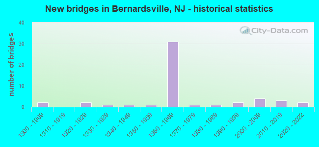
- New bridges - historical statistics
- 21900-1909
- 21920-1929
- 11930-1939
- 11940-1949
- 11950-1959
- 311960-1969
- 11970-1979
- 11980-1989
- 21990-1999
- 42000-2009
- 32010-2019
- 22020-2022

- Reconstructed bridges - Historical Statistics
- 11960-1969
- 11970-1979
- 21980-1989
- 71990-1999
- 32000-2009


- Bridge Condition - Deck
- 10.0%Very good
- 43.3%Good
- 23.3%Satisfactory
- 13.3%Fair
- 10.0%Poor

- Bridge Condition - Superstructure
- 3.0%Excellent
- 15.2%Very good
- 36.4%Good
- 27.3%Satisfactory
- 12.1%Fair
- 6.1%Poor

- Bridge Condition - Substructure
- 3.0%Excellent
- 15.2%Very good
- 27.3%Good
- 39.4%Satisfactory
- 12.1%Fair
- 3.0%Poor

- Bridge Condition - Channel
- 8.3%Very good
- 45.8%Good
- 41.7%Satisfactory
- 4.2%Fair

- Bridge Condition - Culverts
- 20.0%Good
- 60.0%Satisfactory
- 20.0%Fair
Find on map >> Show street view
Structure Number: 140054, Location: 0.16 MI WEST OF CR 605 (Lat: 40.671039, Lng: -74.525839), Route carried "on" structure: City street , Year Built: 2009, Status: Open, Structure Length: 2.13m (6.99ft), Average Daily Traffic: 1,833 (year 2021), Truck Traffic: 1%, Average Future Daily Traffic: 2,199 (year 2041), Design Load: HS 25 or greater, Features Intersected: PASSAIC RIVER, Facility Carried by Structure: STONE HOUSE ROAD
Minimum Vertical Clearance: 30+ m (98+ ft), Kilometerpoint: 0.000, Lanes on structure: 2, Owner: County Highway Agency, Approaching Roadway Width: 9.1m (29.9ft), Material/Design: Prestressed concrete, Design/Construction: Box Beam or Girders - Multiple, Number Of Spans In Main Unit: 1, Length of Maximum Span: 20.1m (65.9ft), Curb-To-Curb Width: 9.1m (29.9ft), Out-to-Out Width: 10.8m (35.4ft)
Condition: Deck: Good, Superstructure: Good, Substructure: Good, Channel: Satisfactory, Inventory Rating: 55.3 metric tons, Method Used To Determine Inventory Rating: Load Factor (LF), Structural Evaluation: Better than present minimum criteria, Deck Geometry: Somewhat better than minimum adequacy, Waterway Adequacy: Superior to present desirable criteria, Approach Roadway Alignment: Equal to present desirable criteria, Designated Inspection Frequency: Every 24 months, Inspection Date: September 2021, Deck Structure Type: Concrete Cast-file-Place, Wearing Surface/Protective System: Deck Protection: Epoxy Coated Reinforcing
Find on map >> Show street view
Structure Number: 1400541, Location: 0.60 MI WEST OF CR 605 (Lat: 40.681250, Lng: -74.528650), Route carried "on" structure: County highway 657, Year Built: 1928, Status: Open, Structure Length: 2.80m (9.19ft), Average Daily Traffic: 6,387 (year 2021), Truck Traffic: 4%, Average Future Daily Traffic: 7,664 (year 2041), Features Intersected: PASSAIC RIVER, Facility Carried by Structure: BASKING RIDGE ROAD
Minimum Vertical Clearance: 30+ m (98+ ft), Kilometerpoint: 0.000, Lanes on structure: 2, Owner: County Highway Agency, Approaching Roadway Width: 11.6m (38.1ft), Material/Design: Concrete, Design/Construction: Arch - Deck, Number Of Spans In Main Unit: 1, Length of Maximum Span: 28.0m (91.9ft), Curb or Sidewalk Widths: Left: 1.7m (5.6ft), Right: 1.7m (5.6ft), Curb-To-Curb Width: 11.0m (36.1ft), Out-to-Out Width: 15.3m (50.2ft)
Condition: Superstructure: Satisfactory, Substructure: Satisfactory, Channel: Satisfactory, Operating Rating: 33.6 metric tons, Method Used To Determine Operating Rating: Load Factor (LF), Inventory Rating: 20.0 metric tons, Method Used To Determine Inventory Rating: Load Factor (LF), Structural Evaluation: Somewhat better than minimum adequacy, Deck Geometry: Meets minimum limits, Waterway Adequacy: Superior to present desirable criteria, Approach Roadway Alignment: Equal to present desirable criteria, Designated Inspection Frequency: Every 24 months, Inspection Date: July 2021
Find on map >> Show street view
Structure Number: 1400548, Location: 2.5 MI E OF I-287 EXIT 30 (Lat: 40.722350, Lng: -74.492789), Route carried "on" structure: County highway 604, Year Built: 1993, Status: Open, Structure Length: 0.61m (2.00ft), Average Daily Traffic: 5,360 (year 2021), Truck Traffic: 3%, Average Future Daily Traffic: 6,540 (year 2041), Design Load: HS 25 or greater, Features Intersected: TRIB. OF GREAT BROOK
Minimum Vertical Clearance: 30+ m (98+ ft), Kilometerpoint: 4.249, Lanes on structure: 2, Owner: County Highway Agency, Approaching Roadway Width: 6.7m (22.0ft), Material/Design: Concrete, Design/Construction: Culvert, Number Of Spans In Main Unit: 1, Length of Maximum Span: 6.1m (20.0ft), Curb-To-Curb Width: 7.9m (25.9ft), Out-to-Out Width: 8.6m (28.2ft)
Condition: Channel: Very good, Culverts: Satisfactory, Operating Rating: 85.3 metric tons, Method Used To Determine Operating Rating: Load Factor (LF), Inventory Rating: 50.8 metric tons, Method Used To Determine Inventory Rating: Load Factor (LF), Structural Evaluation: Equal to present minimum criteria, Deck Geometry: High priority of replacement, Waterway Adequacy: Equal to present minimum criteria, Approach Roadway Alignment: Equal to present minimum criteria, Designated Inspection Frequency: Every 24 months, Underwater Inspection Frequency: Every 24 months, Inspection Date: June 2021, Underwater Inspection Date: July 2021, Deck Structure Type: Concrete Cast-file-Place, Wearing Surface/Protective System: Wearing Surface: Monolithic Concrete, Deck Protection: Epoxy Coated Reinforcing
Find on map >> Show street view
Structure Number: 1400563, Location: 1.3 MILES NORTH OF CR 657 (Lat: 40.694500, Lng: -74.514439), Route carried "on" structure: City street , Year Built: 2010, Status: Open, Structure Length: 2.29m (7.51ft), Average Daily Traffic: 2,881 (year 2021), Truck Traffic: 1%, Average Future Daily Traffic: 3,457 (year 2041), Design Load: HL 93, Features Intersected: PASSAIC RIVER, Facility Carried by Structure: WHITE BRIDGE ROAD
Minimum Vertical Clearance: 30+ m (98+ ft), Kilometerpoint: 0.000, Lanes on structure: 2, Owner: County Highway Agency, Approaching Roadway Width: 8.5m (27.9ft), Material/Design: Steel, Design/Construction: Truss - Thru, Number Of Spans In Main Unit: 1, Length of Maximum Span: 21.3m (69.9ft), Curb or Sidewalk Widths: Left: 1.5m (4.9ft), Right: 0.0m, Curb-To-Curb Width: 8.5m (27.9ft), Out-to-Out Width: 9.6m (31.5ft)
Condition: Deck: Very good, Superstructure: Very good, Substructure: Very good, Channel: Good, Operating Rating: 48.3 metric tons, Method Used To Determine Operating Rating: Load and Resistance Factor Rating (LRFR) rating reported by rating factor(RF) method using HL-93 loadings, Inventory Rating: 37.3 metric tons, Method Used To Determine Inventory Rating: Load and Resistance Factor Rating (LRFR) rating reported by rating factor(RF) method using HL-93 loadings, Structural Evaluation: Equal to present desirable criteria, Deck Geometry: Meets minimum limits, Waterway Adequacy: Better than present minimum criteria, Approach Roadway Alignment: Better than present minimum criteria, Designated Inspection Frequency: Every 24 months, Critical Feature Inspection Frequency: Every 24 months, Inspection Date: September 2021, Critical Feature Inspection Date: September 2021, Deck Structure Type: Concrete Cast-file-Place, Wearing Surface/Protective System: Wearing Surface: Monolithic Concrete, Deck Protection: Epoxy Coated Reinforcing
Find on map >> Show street view
Structure Number: 1400567, Location: 1.3 MILES WEST OF CR 604 (Lat: 40.696811, Lng: -74.500200), Route carried "on" structure: City street , Year Built: 1953, Year Reconstructed: 1967, Status: Open, Structure Length: 1.46m (4.79ft), Average Daily Traffic: 3,007 (year 2021), Truck Traffic: 1%, Average Future Daily Traffic: 3,608 (year 2041), Features Intersected: BLACK BROOK, Facility Carried by Structure: WHITE BRIDGE ROAD
Minimum Vertical Clearance: 30+ m (98+ ft), Kilometerpoint: 0.000, Lanes on structure: 2, Owner: County Highway Agency, Approaching Roadway Width: 7.3m (24.0ft), Material/Design: Steel continuous, Design/Construction: Stringer/Multi-beam, Number Of Spans In Main Unit: 2, Length of Maximum Span: 7.0m (23.0ft), Curb-To-Curb Width: 8.5m (27.9ft), Out-to-Out Width: 8.7m (28.5ft)
Condition: Deck: Satisfactory, Superstructure: Poor, Substructure: Fair, Channel: Good, Operating Rating: 62.6 metric tons, Method Used To Determine Operating Rating: Load Factor (LF), Inventory Rating: 37.2 metric tons, Method Used To Determine Inventory Rating: Load Factor (LF), Structural Evaluation: Meets minimum limits, Deck Geometry: Meets minimum limits, Waterway Adequacy: Equal to present minimum criteria, Approach Roadway Alignment: Equal to present minimum criteria, Length Of Structure Improvement: 1.46m (4.79ft), Designated Inspection Frequency: Every 24 months, Inspection Date: July 2021, Bridge Improvement Cost: $687,000, Roadway Improvement Cost: $56,000, Total Project Cost: $1,097,000 ( Estimate for 2021), Deck Structure Type: Corrugated Steel, Wearing Surface/Protective System: Wearing Surface: Bituminous
Find on map >> Show street view
Structure Number: 1400569, Location: 1.25MI E OF I-287 EXIT 30 (Lat: 40.728639, Lng: -74.515469), Route carried "on" structure: County highway 663, Year Built: 2000, Status: Open, Structure Length: 0.67m (2.20ft), Average Daily Traffic: 8,193 (year 2021), Truck Traffic: 3%, Average Future Daily Traffic: 9,997 (year 2041), Design Load: HS 25 or greater, Features Intersected: PRIMROSE BROOK
Minimum Vertical Clearance: 30+ m (98+ ft), Kilometerpoint: 1.754, Lanes on structure: 2, Owner: County Highway Agency, Approaching Roadway Width: 8.5m (27.9ft), Material/Design: Concrete, Design/Construction: Frame, Number Of Spans In Main Unit: 1, Length of Maximum Span: 6.1m (20.0ft), Curb-To-Curb Width: 9.0m (29.5ft), Out-to-Out Width: 10.1m (33.1ft)
Condition: Deck: Good, Superstructure: Good, Substructure: Good, Channel: Satisfactory, Operating Rating: 49.0 metric tons, Method Used To Determine Operating Rating: Load Factor (LF), Inventory Rating: 29.0 metric tons, Method Used To Determine Inventory Rating: Load Factor (LF), Structural Evaluation: Better than present minimum criteria, Deck Geometry: High priority of replacement, Waterway Adequacy: Better than present minimum criteria, Approach Roadway Alignment: Equal to present minimum criteria, Length Of Structure Improvement: 0.61m (2.00ft), Designated Inspection Frequency: Every 24 months, Inspection Date: June 2021, Bridge Improvement Cost: $25,000, Roadway Improvement Cost: $24,000, Total Project Cost: $79,000 ( Estimate for 2021), Deck Structure Type: Concrete Precast Panels, Wearing Surface/Protective System: Wearing Surface: Bituminous, Deck Protection: Epoxy Coated Reinforcing
Find on map >> Show street view
Structure Number: 1400658, Location: 1.4 Ml NW of Rt. 202 (Lat: 40.761250, Lng: -74.554061), Route carried "on" structure: City street , Year Built: 1980, Status: Open, Structure Length: 0.67m (2.20ft), Average Daily Traffic: 1,592 (year 2021), Truck Traffic: 1%, Average Future Daily Traffic: 1,943 (year 2041), Features Intersected: PASSAIC RIVER, Facility Carried by Structure: LEDDELL ROAD
Minimum Vertical Clearance: 30+ m (98+ ft), Kilometerpoint: 0.000, Lanes on structure: 2, Owner: County Highway Agency, Approaching Roadway Width: 8.5m (27.9ft), Material/Design: Steel, Design/Construction: Culvert, Number Of Spans In Main Unit: 2, Length of Maximum Span: 3.0m (9.8ft), Curb-To-Curb Width: 8.7m (28.5ft), Out-to-Out Width: 9.3m (30.5ft)
Condition: Channel: Fair, Culverts: Good, Operating Rating: 51.7 metric tons, Method Used To Determine Operating Rating: Field evaluation and documented engineering judgment, Inventory Rating: 30.8 metric tons, Method Used To Determine Inventory Rating: Field evaluation and documented engineering judgment, Structural Evaluation: Better than present minimum criteria, Deck Geometry: Somewhat better than minimum adequacy, Waterway Adequacy: Better than present minimum criteria, Approach Roadway Alignment: Better than present minimum criteria, Designated Inspection Frequency: Every 24 months, Inspection Date: August 2021
Find on map >> Show street view
Structure Number: 1400669, Location: 0.1 MILE N. OF JCT NJ 24 (Lat: 40.790850, Lng: -74.550800), Route carried "on" structure: Other road , Year Built: 2007, Status: Open, Structure Length: 1.34m (4.40ft), Average Daily Traffic: 1,332 (year 2021), Truck Traffic: 1%, Average Future Daily Traffic: 1,626 (year 2041), Design Load: HS 25 or greater, Features Intersected: WHIPPANY RIVER, Facility Carried by Structure: TINGLEY RD
Minimum Vertical Clearance: 30+ m (98+ ft), Kilometerpoint: 0.000, Lanes on structure: 2, Owner: County Highway Agency, Approaching Roadway Width: 7.9m (25.9ft), Material/Design: Prestressed concrete, Design/Construction: Slab, Number Of Spans In Main Unit: 1, Length of Maximum Span: 11.9m (39.0ft), Curb-To-Curb Width: 7.9m (25.9ft), Out-to-Out Width: 8.9m (29.2ft)
Condition: Deck: Very good, Superstructure: Very good, Substructure: Very good, Channel: Good, Operating Rating: 53.5 metric tons, Method Used To Determine Operating Rating: Load Factor (LF), Inventory Rating: 31.8 metric tons, Method Used To Determine Inventory Rating: Load Factor (LF), Structural Evaluation: Better than present minimum criteria, Deck Geometry: Meets minimum limits, Waterway Adequacy: Better than present minimum criteria, Approach Roadway Alignment: Equal to present minimum criteria, Designated Inspection Frequency: Every 24 months, Inspection Date: July 2021, Deck Structure Type: Concrete Cast-file-Place, Wearing Surface/Protective System: Deck Protection: Epoxy Coated Reinforcing
Find on map >> Show street view
Structure Number: 1419155, Location: 2.5 MI NO OF RT 527 JCT (Lat: 40.744131, Lng: -74.531319), Route carried "on" structure: City street , Year Built: 1968, Status: Open, Structure Length: 3.54m (11.61ft), Average Daily Traffic: 2,990 (year 2021), Truck Traffic: 1%, Average Future Daily Traffic: 3,590 (year 2041), Design Load: H 20, Features Intersected: I-287 NB, Facility Carried by Structure: BAILEY'S MILL RD
Minimum Vertical Clearance: 30+ m (98+ ft), Kilometerpoint: 0.000, Lanes on structure: 2, Lanes under structure: 3, Owner: State Highway Agency, Approaching Roadway Width: 9.1m (29.9ft), Material/Design: Steel, Design/Construction: Stringer/Multi-beam, Number Of Spans In Main Unit: 1, Length of Maximum Span: 33.5m (109.9ft), Curb or Sidewalk Widths: Left: 1.8m (5.9ft), Right: 0.5m (1.6ft), Curb-To-Curb Width: 9.1m (29.9ft), Out-to-Out Width: 12.0m (39.4ft)
Condition: Deck: Satisfactory, Superstructure: Good, Substructure: Very good, Operating Rating: 68.9 metric tons, Method Used To Determine Operating Rating: Load Factor (LF), Inventory Rating: 40.8 metric tons, Method Used To Determine Inventory Rating: Load Factor (LF), Structural Evaluation: Better than present minimum criteria, Deck Geometry: Meets minimum limits, Underclear: Somewhat better than minimum adequacy, Approach Roadway Alignment: Equal to present desirable criteria, Designated Inspection Frequency: Every 24 months, Inspection Date: August 2021, Deck Structure Type: Concrete Cast-file-Place, Wearing Surface/Protective System: Wearing Surface: Monolithic Concrete
Find on map >> Show street view
Structure Number: 1419156, Location: 5.0 MI. SO. OF JCT. 24 (Lat: 40.744531, Lng: -74.532131), Route carried "on" structure: City street , Year Built: 1968, Status: Open, Structure Length: 3.54m (11.61ft), Average Daily Traffic: 2,770 (year 2021), Truck Traffic: 1%, Average Future Daily Traffic: 3,325 (year 2041), Design Load: H 20, Features Intersected: I-287 SB, Facility Carried by Structure: BAILEY'S MILL ROAD
Minimum Vertical Clearance: 30+ m (98+ ft), Kilometerpoint: 0.000, Lanes on structure: 2, Lanes under structure: 3, Owner: State Highway Agency, Approaching Roadway Width: 9.1m (29.9ft), Material/Design: Steel, Design/Construction: Stringer/Multi-beam, Number Of Spans In Main Unit: 1, Length of Maximum Span: 33.5m (109.9ft), Curb or Sidewalk Widths: Left: 1.8m (5.9ft), Right: 0.5m (1.6ft), Curb-To-Curb Width: 9.1m (29.9ft), Out-to-Out Width: 12.0m (39.4ft)
Condition: Deck: Satisfactory, Superstructure: Good, Substructure: Good, Inventory Rating: 54.4 metric tons, Method Used To Determine Inventory Rating: Load Factor (LF), Structural Evaluation: Better than present minimum criteria, Deck Geometry: Meets minimum limits, Underclear: Somewhat better than minimum adequacy, Approach Roadway Alignment: Equal to present desirable criteria, Length Of Structure Improvement: 3.54m (11.61ft), Designated Inspection Frequency: Every 24 months, Inspection Date: August 2021, Bridge Improvement Cost: $1,265,000, Roadway Improvement Cost: $126,000, Total Project Cost: $1,967,000 ( Estimate for 2021), Deck Structure Type: Concrete Cast-file-Place, Wearing Surface/Protective System: Wearing Surface: Monolithic Concrete
Find on map >> Show street view
Structure Number: 1419159, Location: 0.05 MI EAST OF US 202 (Lat: 40.754031, Lng: -74.524900), Route carried "on" structure: County highway 646, Year Built: 1968, Year Reconstructed: 1994, Status: Open, Structure Length: 6.71m (22.01ft), Average Daily Traffic: 8,384 (year 2021), Truck Traffic: 4%, Average Future Daily Traffic: 10,062 (year 2041), Design Load: HS 20, Features Intersected: I-287, Facility Carried by Structure: GLEN ALPINE ROAD
Minimum Vertical Clearance: 30+ m (98+ ft), Kilometerpoint: 6.920, Lanes on structure: 2, Lanes under structure: 6, Owner: State Highway Agency, Approaching Roadway Width: 11.6m (38.1ft), Material/Design: Steel, Design/Construction: Stringer/Multi-beam, Number Of Spans In Main Unit: 3, Length of Maximum Span: 26.2m (86.0ft), Curb or Sidewalk Widths: Left: 1.8m (5.9ft), Right: 0.5m (1.6ft), Curb-To-Curb Width: 9.1m (29.9ft), Out-to-Out Width: 12.0m (39.4ft)
Condition: Deck: Fair, Superstructure: Satisfactory, Substructure: Fair, Inventory Rating: 58.1 metric tons, Method Used To Determine Inventory Rating: Load Factor (LF), Structural Evaluation: Somewhat better than minimum adequacy, Deck Geometry: Meets minimum limits, Underclear: Somewhat better than minimum adequacy, Approach Roadway Alignment: Equal to present desirable criteria, Designated Inspection Frequency: Every 24 months, Inspection Date: October 2021, Deck Structure Type: Concrete Cast-file-Place, Wearing Surface/Protective System: Wearing Surface: Bituminous
Find on map >> Show street view
Structure Number: 1809158, Location: 5.4 MI SOUTH OF RT 124 (Lat: 40.733489, Lng: -74.539950), Route carried "on" structure: US 202, Year Built: 2012, Status: Open, Structure Length: 2.90m (9.51ft), Average Daily Traffic: 11,215 (year 2021), Truck Traffic: 4%, Average Future Daily Traffic: 13,457 (year 2041), Design Load: HL 93, Features Intersected: PASSAIC RIVER
Minimum Vertical Clearance: 30+ m (98+ ft), Kilometerpoint: 62.893, Lanes on structure: 2, Owner: State Highway Agency, Approaching Roadway Width: 9.4m (30.8ft), Skew: 3 degrees, Material/Design: Steel, Design/Construction: Stringer/Multi-beam, Number Of Spans In Main Unit: 1, Length of Maximum Span: 27.1m (88.9ft), Curb-To-Curb Width: 9.4m (30.8ft), Out-to-Out Width: 11.0m (36.1ft)
Condition: Deck: Good, Superstructure: Very good, Substructure: Very good, Channel: Good, Operating Rating: 64.5 metric tons, Method Used To Determine Operating Rating: Load and Resistance Factor Rating (LRFR) rating reported by rating factor(RF) method using HL-93 loadings, Inventory Rating: 49.6 metric tons, Method Used To Determine Inventory Rating: Load and Resistance Factor Rating (LRFR) rating reported by rating factor(RF) method using HL-93 loadings, Structural Evaluation: Equal to present desirable criteria, Deck Geometry: High priority of corrective action, Waterway Adequacy: Better than present minimum criteria, Approach Roadway Alignment: Equal to present desirable criteria, Designated Inspection Frequency: Every 24 months, Inspection Date: May 2021, Deck Structure Type: Concrete Precast Panels, Wearing Surface/Protective System: Wearing Surface: Bituminous, Membrane: Other, Deck Protection: Epoxy Coated Reinforcing
Find on map >> Show street view
Structure Number: 1815166, Location: AT I-287 EXIT 26 (Lat: 40.688869, Lng: -74.577200), Route carried "on" structure: Interstate 287, Year Built: 1968, Year Reconstructed: 1997, Status: Open, Structure Length: 3.20m (10.50ft), Average Daily Traffic: 59,200 (year 2020), Truck Traffic: 9%, Average Future Daily Traffic: 71,100 (year 2040), Design Load: HS 20+Mod, Features Intersected: MOUNT AIRY ROAD (CO.525)
Minimum Vertical Clearance: 30+ m (98+ ft), Kilometerpoint: 42.615, Lanes on structure: 4, Lanes under structure: 3, Base Highway Network: Yes, Owner: State Highway Agency, Approaching Roadway Width: 19.8m (65.0ft), Skew: 1 degrees, Material/Design: Steel, Design/Construction: Stringer/Multi-beam, Number Of Spans In Main Unit: 3, Length of Maximum Span: 19.2m (63.0ft), Curb-To-Curb Width: 19.8m (65.0ft), Out-to-Out Width: 20.9m (68.6ft)
Condition: Deck: Good, Superstructure: Good, Substructure: Satisfactory, Operating Rating: 70.8 metric tons, Method Used To Determine Operating Rating: Load Factor (LF), Inventory Rating: 42.6 metric tons, Method Used To Determine Inventory Rating: Load Factor (LF), Structural Evaluation: Equal to present minimum criteria, Deck Geometry: Equal to present minimum criteria, Underclear: Equal to present minimum criteria, Approach Roadway Alignment: Equal to present desirable criteria, Designated Inspection Frequency: Every 24 months, Inspection Date: June 2020, Deck Structure Type: Concrete Cast-file-Place, Wearing Surface/Protective System: Wearing Surface: Bituminous
Find on map >> Show street view
Structure Number: 1815167, Location: 4.4MI NORTH OF 202&206 (Lat: 40.689611, Lng: -74.577139), Route carried "on" structure: Interstate 287, Year Built: 1968, Year Reconstructed: 1997, Status: Open, Structure Length: 3.20m (10.50ft), Average Daily Traffic: 57,200 (year 2020), Truck Traffic: 9%, Average Future Daily Traffic: 68,600 (year 2040), Design Load: HS 25 or greater, Features Intersected: MT AIRY RD(CR 525)
Minimum Vertical Clearance: 30+ m (98+ ft), Kilometerpoint: 42.615, Lanes on structure: 4, Lanes under structure: 3, Base Highway Network: Yes, Owner: State Highway Agency, Approaching Roadway Width: 21.9m (71.9ft), Skew: 1 degrees, Material/Design: Steel, Design/Construction: Stringer/Multi-beam, Number Of Spans In Main Unit: 3, Length of Maximum Span: 19.5m (64.0ft), Curb-To-Curb Width: 20.9m (68.6ft), Out-to-Out Width: 22.0m (72.2ft)
Condition: Deck: Good, Superstructure: Satisfactory, Substructure: Fair, Operating Rating: 75.3 metric tons, Method Used To Determine Operating Rating: Load Factor (LF), Inventory Rating: 45.4 metric tons, Method Used To Determine Inventory Rating: Load Factor (LF), Structural Evaluation: Somewhat better than minimum adequacy, Deck Geometry: Better than present minimum criteria, Underclear: Equal to present minimum criteria, Approach Roadway Alignment: Equal to present desirable criteria, Designated Inspection Frequency: Every 24 months, Inspection Date: August 2020, Deck Structure Type: Concrete Cast-file-Place, Wearing Surface/Protective System: Wearing Surface: Latex Concrete, Deck Protection: Epoxy Coated Reinforcing
Find on map >> Show street view
Structure Number: 1815171, Location: 1.48MI. NO. OF INTRCH 26 (Lat: 40.705611, Lng: -74.561569), Route carried "on" structure: County highway 624, Year Built: 1968, Year Reconstructed: 2006, Status: Open, Structure Length: 4.05m (13.29ft), Average Daily Traffic: 5,745 (year 2021), Truck Traffic: 3%, Average Future Daily Traffic: 6,894 (year 2041), Design Load: HS 20, Features Intersected: I-287 NB
Minimum Vertical Clearance: 30+ m (98+ ft), Kilometerpoint: 0.591, Lanes on structure: 2, Lanes under structure: 3, Owner: State Highway Agency, Approaching Roadway Width: 9.1m (29.9ft), Skew: 3 degrees, Material/Design: Steel, Design/Construction: Stringer/Multi-beam, Number Of Spans In Main Unit: 3, Length of Maximum Span: 21.9m (71.9ft), Curb or Sidewalk Widths: Left: 1.8m (5.9ft), Right: 1.8m (5.9ft), Curb-To-Curb Width: 9.1m (29.9ft), Out-to-Out Width: 13.6m (44.6ft)
Condition: Deck: Good, Superstructure: Good, Substructure: Good, Inventory Rating: 54.4 metric tons, Method Used To Determine Inventory Rating: Load Factor (LF), Structural Evaluation: Better than present minimum criteria, Deck Geometry: High priority of corrective action, Underclear: Somewhat better than minimum adequacy, Approach Roadway Alignment: Equal to present desirable criteria, Length Of Structure Improvement: 4.05m (13.29ft), Designated Inspection Frequency: Every 24 months, Inspection Date: May 2021, Bridge Improvement Cost: $53,000, Roadway Improvement Cost: $106,000, Total Project Cost: $244,000 ( Estimate for 2021), Deck Structure Type: Concrete Cast-file-Place, Wearing Surface/Protective System: Wearing Surface: Monolithic Concrete
Find on map >> Show street view
Structure Number: 1815172, Location: 5.7 MI NO. OF RT 18 JCT. (Lat: 40.705611, Lng: -74.561550), Route carried "on" structure: County highway 624, Year Built: 1966, Year Reconstructed: 2006, Status: Open, Structure Length: 4.02m (13.19ft), Average Daily Traffic: 5,690 (year 2020), Truck Traffic: 3%, Average Future Daily Traffic: 6,830 (year 2040), Design Load: HL 93, Features Intersected: I-287 SB
Minimum Vertical Clearance: 30+ m (98+ ft), Kilometerpoint: 0.563, Lanes on structure: 2, Lanes under structure: 3, Owner: State Highway Agency, Approaching Roadway Width: 9.1m (29.9ft), Skew: 3 degrees, Material/Design: Steel, Design/Construction: Stringer/Multi-beam, Number Of Spans In Main Unit: 3, Length of Maximum Span: 21.9m (71.9ft), Curb or Sidewalk Widths: Left: 1.4m (4.6ft), Right: 1.8m (5.9ft), Curb-To-Curb Width: 9.1m (29.9ft), Out-to-Out Width: 13.6m (44.6ft)
Condition: Deck: Good, Superstructure: Good, Substructure: Good, Operating Rating: 71.6 metric tons, Method Used To Determine Operating Rating: Load and Resistance Factor Rating (LRFR) rating reported by rating factor(RF) method using HL-93 loadings, Inventory Rating: 64.8 metric tons, Method Used To Determine Inventory Rating: Load and Resistance Factor Rating (LRFR) rating reported by rating factor(RF) method using HL-93 loadings, Structural Evaluation: Better than present minimum criteria, Deck Geometry: High priority of corrective action, Underclear: Somewhat better than minimum adequacy, Approach Roadway Alignment: Equal to present desirable criteria, Length Of Structure Improvement: 4.02m (13.19ft), Designated Inspection Frequency: Every 24 months, Inspection Date: May 2020, Bridge Improvement Cost: $182,000, Roadway Improvement Cost: $50,000, Total Project Cost: $278,000 ( Estimate for 2020), Deck Structure Type: Concrete Cast-file-Place, Wearing Surface/Protective System: Deck Protection: Epoxy Coated Reinforcing
Find on map >> Show street view
Structure Number: 1815174, Location: 1.93 MI NORTH OF EXIT 26 (Lat: 40.711889, Lng: -74.557261), Route carried "on" structure: City street , Year Built: 1966, Status: Open, Structure Length: 6.89m (22.60ft), Average Daily Traffic: 2,264 (year 2021), Truck Traffic: 1%, Average Future Daily Traffic: 2,717 (year 2041), Design Load: HS 20, Features Intersected: I-287, Facility Carried by Structure: WASHINGTON AVE
Minimum Vertical Clearance: 30+ m (98+ ft), Kilometerpoint: 0.000, Lanes on structure: 2, Lanes under structure: 6, Owner: State Highway Agency, Approaching Roadway Width: 9.1m (29.9ft), Skew: 2 degrees, Material/Design: Steel, Design/Construction: Stringer/Multi-beam, Number Of Spans In Main Unit: 2, Length of Maximum Span: 33.5m (109.9ft), Curb or Sidewalk Widths: Left: 1.8m (5.9ft), Right: 1.8m (5.9ft), Curb-To-Curb Width: 9.1m (29.9ft), Out-to-Out Width: 13.6m (44.6ft)
Condition: Deck: Fair, Superstructure: Satisfactory, Substructure: Satisfactory, Operating Rating: 66.2 metric tons, Method Used To Determine Operating Rating: Load Factor (LF), Inventory Rating: 39.0 metric tons, Method Used To Determine Inventory Rating: Load Factor (LF), Structural Evaluation: Equal to present minimum criteria, Deck Geometry: Meets minimum limits, Underclear: Somewhat better than minimum adequacy, Approach Roadway Alignment: Equal to present desirable criteria, Designated Inspection Frequency: Every 24 months, Inspection Date: May 2021, Deck Structure Type: Concrete Cast-file-Place, Wearing Surface/Protective System: Wearing Surface: Monolithic Concrete
Find on map >> Show street view
Structure Number: 1815176, Location: 2.11 MI N of Intrchg 26 (Lat: 40.713769, Lng: -74.555289), Route carried "on" structure: Interstate 287, Year Built: 1966, Year Reconstructed: 1997, Status: Open, Structure Length: 3.63m (11.91ft), Average Daily Traffic: 47,654 (year 2021), Truck Traffic: 9%, Average Future Daily Traffic: 57,185 (year 2041), Design Load: HS 20, Features Intersected: N.FINLEY AVE (CR 613)
Minimum Vertical Clearance: 30+ m (98+ ft), Kilometerpoint: 46.011, Lanes on structure: 3, Lanes under structure: 2, Base Highway Network: Yes, Owner: State Highway Agency, Approaching Roadway Width: 16.8m (55.1ft), Skew: 3 degrees, Material/Design: Steel, Design/Construction: Stringer/Multi-beam, Number Of Spans In Main Unit: 3, Length of Maximum Span: 20.7m (67.9ft), Curb-To-Curb Width: 16.8m (55.1ft), Out-to-Out Width: 18.6m (61.0ft)
Condition: Deck: Good, Superstructure: Good, Substructure: Good, Operating Rating: 71.7 metric tons, Method Used To Determine Operating Rating: Load Factor (LF), Inventory Rating: 42.6 metric tons, Method Used To Determine Inventory Rating: Load Factor (LF), Structural Evaluation: Better than present minimum criteria, Deck Geometry: Equal to present minimum criteria, Underclear: Somewhat better than minimum adequacy, Approach Roadway Alignment: Equal to present desirable criteria, Designated Inspection Frequency: Every 24 months, Inspection Date: May 2021, Deck Structure Type: Concrete Cast-file-Place, Wearing Surface/Protective System: Wearing Surface: Bituminous, Deck Protection: Epoxy Coated Reinforcing
Find on map >> Show street view
Structure Number: 1815177, Location: 1.35 MI S of Intchg 30 (Lat: 40.714469, Lng: -74.555369), Route carried "on" structure: Interstate 287, Year Built: 1966, Year Reconstructed: 1997, Status: Open, Structure Length: 3.75m (12.30ft), Average Daily Traffic: 47,654 (year 2021), Truck Traffic: 9%, Average Future Daily Traffic: 57,185 (year 2041), Design Load: HS 20, Features Intersected: N. FINLEY AVE (CR 613)
Minimum Vertical Clearance: 30+ m (98+ ft), Kilometerpoint: 46.011, Lanes on structure: 3, Lanes under structure: 2, Base Highway Network: Yes, Owner: State Highway Agency, Approaching Roadway Width: 16.8m (55.1ft), Skew: 3 degrees, Material/Design: Steel, Design/Construction: Stringer/Multi-beam, Number Of Spans In Main Unit: 3, Length of Maximum Span: 21.6m (70.9ft), Curb-To-Curb Width: 16.8m (55.1ft), Out-to-Out Width: 17.8m (58.4ft)
Condition: Deck: Good, Superstructure: Good, Substructure: Satisfactory, Operating Rating: 70.8 metric tons, Method Used To Determine Operating Rating: Load Factor (LF), Inventory Rating: 41.7 metric tons, Method Used To Determine Inventory Rating: Load Factor (LF), Structural Evaluation: Equal to present minimum criteria, Deck Geometry: Equal to present minimum criteria, Underclear: Somewhat better than minimum adequacy, Approach Roadway Alignment: Equal to present desirable criteria, Designated Inspection Frequency: Every 24 months, Inspection Date: May 2021, Deck Structure Type: Concrete Cast-file-Place, Wearing Surface/Protective System: Wearing Surface: Latex Concrete, Deck Protection: Epoxy Coated Reinforcing
Find on map >> Show street view
Structure Number: 1815179, Location: 8.1 MI NORTH OF I-78 JCT (Lat: 40.721719, Lng: -74.547689), Route carried "on" structure: City street , Year Built: 1966, Status: Open, Structure Length: 6.68m (21.92ft), Average Daily Traffic: 5,955 (year 2020), Truck Traffic: 3%, Average Future Daily Traffic: 7,267 (year 2040), Design Load: HS 20, Features Intersected: I-287, Facility Carried by Structure: MADISONVILLE ROAD
Minimum Vertical Clearance: 30+ m (98+ ft), Kilometerpoint: 0.644, Lanes on structure: 2, Lanes under structure: 6, Owner: State Highway Agency, Approaching Roadway Width: 9.1m (29.9ft), Skew: 3 degrees, Material/Design: Steel, Design/Construction: Stringer/Multi-beam, Number Of Spans In Main Unit: 2, Length of Maximum Span: 33.2m (108.9ft), Curb or Sidewalk Widths: Left: 0.5m (1.6ft), Right: 1.8m (5.9ft), Curb-To-Curb Width: 9.1m (29.9ft), Out-to-Out Width: 12.2m (40.0ft)
Condition: Deck: Good, Superstructure: Satisfactory, Substructure: Satisfactory, Operating Rating: 88.9 metric tons, Method Used To Determine Operating Rating: Load Factor (LF), Inventory Rating: 52.6 metric tons, Method Used To Determine Inventory Rating: Load Factor (LF), Structural Evaluation: Equal to present minimum criteria, Deck Geometry: Meets minimum limits, Underclear: Somewhat better than minimum adequacy, Approach Roadway Alignment: Equal to present minimum criteria, Designated Inspection Frequency: Every 24 months, Inspection Date: May 2020, Deck Structure Type: Concrete Cast-file-Place, Wearing Surface/Protective System: Wearing Surface: Monolithic Concrete
Find on map >> Show street view
Structure Number: 181518, Location: AT I-287 EXIT 30 (Lat: 40.728989, Lng: -74.539139), Route carried "on" structure: City street , Year Built: 1966, Status: Open, Structure Length: 4.15m (13.62ft), Average Daily Traffic: 10,720 (year 2020), Truck Traffic: 4%, Average Future Daily Traffic: 12,865 (year 2040), Design Load: HS 20, Features Intersected: I-287 NB, Facility Carried by Structure: NORTH MAPLE AVE.
Minimum Vertical Clearance: 30+ m (98+ ft), Kilometerpoint: 2.784, Lanes on structure: 2, Lanes under structure: 4, Owner: State Highway Agency, Approaching Roadway Width: 14.0m (45.9ft), Skew: 3 degrees, Material/Design: Steel, Design/Construction: Stringer/Multi-beam, Number Of Spans In Main Unit: 3, Length of Maximum Span: 22.9m (75.1ft), Curb or Sidewalk Widths: Left: 0.5m (1.6ft), Right: 1.8m (5.9ft), Curb-To-Curb Width: 14.0m (45.9ft), Out-to-Out Width: 17.1m (56.1ft)
Condition: Deck: Poor, Superstructure: Satisfactory, Substructure: Satisfactory, Operating Rating: 78.9 metric tons, Method Used To Determine Operating Rating: Load Factor (LF), Inventory Rating: 47.2 metric tons, Method Used To Determine Inventory Rating: Load Factor (LF), Structural Evaluation: Equal to present minimum criteria, Deck Geometry: Superior to present desirable criteria, Underclear: Meets minimum limits, Approach Roadway Alignment: Equal to present desirable criteria, Length Of Structure Improvement: 4.15m (13.62ft), Designated Inspection Frequency: Every 24 months, Inspection Date: May 2020, Bridge Improvement Cost: $1,714,000, Roadway Improvement Cost: $171,000, Total Project Cost: $2,200,000 ( Estimate for 2020), Deck Structure Type: Concrete Cast-file-Place, Wearing Surface/Protective System: Wearing Surface: Monolithic Concrete
Find on map >> Show street view
Structure Number: 1815181, Location: AT I-287 EXIT 30 (Lat: 40.729200, Lng: -74.539319), Route carried "on" structure: City street , Year Built: 1966, Status: Open, Structure Length: 4.15m (13.62ft), Average Daily Traffic: 10,720 (year 2020), Truck Traffic: 4%, Average Future Daily Traffic: 12,865 (year 2040), Design Load: HS 20+Mod, Features Intersected: I-287 SB, Facility Carried by Structure: NORTH MAPLE AVE.
Minimum Vertical Clearance: 30+ m (98+ ft), Kilometerpoint: 2.784, Lanes on structure: 2, Lanes under structure: 4, Owner: State Highway Agency, Approaching Roadway Width: 14.0m (45.9ft), Skew: 3 degrees, Material/Design: Steel, Design/Construction: Stringer/Multi-beam, Number Of Spans In Main Unit: 3, Length of Maximum Span: 22.9m (75.1ft), Curb or Sidewalk Widths: Left: 0.5m (1.6ft), Right: 1.8m (5.9ft), Curb-To-Curb Width: 14.0m (45.9ft), Out-to-Out Width: 17.1m (56.1ft)
Condition: Deck: Poor, Superstructure: Satisfactory, Substructure: Satisfactory, Operating Rating: 78.9 metric tons, Method Used To Determine Operating Rating: Load Factor (LF), Inventory Rating: 47.2 metric tons, Method Used To Determine Inventory Rating: Load Factor (LF), Structural Evaluation: Equal to present minimum criteria, Deck Geometry: Superior to present desirable criteria, Underclear: Somewhat better than minimum adequacy, Approach Roadway Alignment: Equal to present desirable criteria, Length Of Structure Improvement: 4.15m (13.62ft), Designated Inspection Frequency: Every 24 months, Inspection Date: May 2020, Bridge Improvement Cost: $1,714,000, Roadway Improvement Cost: $171,000, Total Project Cost: $2,200,000 ( Estimate for 2020), Deck Structure Type: Concrete Cast-file-Place, Wearing Surface/Protective System: Wearing Surface: Monolithic Concrete
Find on map >> Show street view
Structure Number: 1815182, Location: I-287 & PASSAIC RIVER (Lat: 40.731669, Lng: -74.536669), Route carried "on" structure: Interstate 287, Year Built: 1968, Year Reconstructed: 1997, Status: Open, Structure Length: 1.58m (5.18ft), Average Daily Traffic: 26,971 (year 2021), Truck Traffic: 9%, Average Future Daily Traffic: 32,365 (year 2041), Design Load: HS 20, Features Intersected: PASSAIC RIVER
Minimum Vertical Clearance: 30+ m (98+ ft), Kilometerpoint: 48.554, Lanes on structure: 4, Base Highway Network: Yes, Owner: State Highway Agency, Approaching Roadway Width: 21.9m (71.9ft), Material/Design: Concrete, Design/Construction: Culvert, Number Of Spans In Main Unit: 2, Length of Maximum Span: 7.6m (24.9ft), Curb-To-Curb Width: 19.0m (62.3ft), Out-to-Out Width: 20.1m (65.9ft)
Condition: Channel: Satisfactory, Culverts: Satisfactory, Operating Rating: 43.5 metric tons, Method Used To Determine Operating Rating: Load Factor (LF), Inventory Rating: 26.3 metric tons, Method Used To Determine Inventory Rating: Load Factor (LF), Structural Evaluation: Equal to present minimum criteria, Deck Geometry: Meets minimum limits, Waterway Adequacy: Superior to present desirable criteria, Approach Roadway Alignment: Equal to present desirable criteria, Designated Inspection Frequency: Every 24 months, Inspection Date: May 2021
Find on map >> Show street view
Structure Number: 1815183, Location: 0.25 MI N OF EXIT 30 (Lat: 40.731669, Lng: -74.538331), Route carried "on" structure: Interstate 287, Year Built: 1966, Year Reconstructed: 1997, Status: Open, Structure Length: 1.58m (5.18ft), Average Daily Traffic: 44,060 (year 2021), Truck Traffic: 9%, Average Future Daily Traffic: 52,872 (year 2041), Design Load: HS 20+Mod, Features Intersected: PASSAIC RIVER
Minimum Vertical Clearance: 30+ m (98+ ft), Kilometerpoint: 48.554, Lanes on structure: 4, Base Highway Network: Yes, Owner: State Highway Agency, Approaching Roadway Width: 19.2m (63.0ft), Material/Design: Concrete, Design/Construction: Culvert, Number Of Spans In Main Unit: 2, Length of Maximum Span: 7.6m (24.9ft), Curb-To-Curb Width: 19.2m (63.0ft), Out-to-Out Width: 20.3m (66.6ft)
Condition: Channel: Satisfactory, Culverts: Satisfactory, Operating Rating: 43.5 metric tons, Method Used To Determine Operating Rating: Load Factor (LF), Inventory Rating: 26.3 metric tons, Method Used To Determine Inventory Rating: Load Factor (LF), Structural Evaluation: Equal to present minimum criteria, Deck Geometry: Somewhat better than minimum adequacy, Waterway Adequacy: Superior to present desirable criteria, Approach Roadway Alignment: Equal to present desirable criteria, Designated Inspection Frequency: Every 24 months, Inspection Date: May 2021
Find on map >> Show street view
Structure Number: 1864154, Location: 0.8 MI NW I287& CR613 JCT (Lat: 40.717500, Lng: -74.569000), Route carried "on" structure: County highway 525, Year Built: 1969, Status: Open, Structure Length: 2.77m (9.09ft), Average Daily Traffic: 8,355 (year 2021), Truck Traffic: 4%, Average Future Daily Traffic: 10,193 (year 2041), Design Load: HS 20, Features Intersected: GLADSTONE LINE MP 34.69
Minimum Vertical Clearance: 30+ m (98+ ft), Kilometerpoint: 18.540, Lanes on structure: 2, Owner: State Agenciy, Approaching Roadway Width: 9.1m (29.9ft), Material/Design: Prestressed concrete, Design/Construction: Slab, Number Of Spans In Main Unit: 3, Length of Maximum Span: 11.3m (37.1ft), Curb or Sidewalk Widths: Left: 1.5m (4.9ft), Right: 1.5m (4.9ft), Curb-To-Curb Width: 9.1m (29.9ft), Out-to-Out Width: 12.9m (42.3ft)
Condition: Deck: Fair, Superstructure: Fair, Substructure: Satisfactory, Operating Rating: 57.2 metric tons, Method Used To Determine Operating Rating: Load Factor (LF), Inventory Rating: 31.8 metric tons, Method Used To Determine Inventory Rating: Load Factor (LF), Structural Evaluation: Somewhat better than minimum adequacy, Deck Geometry: High priority of corrective action, Underclear: High priority of replacement, Approach Roadway Alignment: Somewhat better than minimum adequacy, Length Of Structure Improvement: 3.63m (11.91ft), Designated Inspection Frequency: Every 24 months, Inspection Date: Febuary 2021, Bridge Improvement Cost: $4,659,000, Roadway Improvement Cost: $466,000, Total Project Cost: $9,117,000 ( Estimate for 2021), Deck Structure Type: Concrete Precast Panels, Wearing Surface/Protective System: Wearing Surface: Bituminous, Membrane: Epoxy
Find on map >> Show street view
Structure Number: 18F1105, Location: 1.7 MI W OF RT 525 (Lat: 40.666089, Lng: -74.596661), Route carried "on" structure: County highway 512, Year Built: 2021, Status: Closed, Structure Length: 1.34m (4.40ft), Average Daily Traffic: 10,652 (year 2021), Truck Traffic: 3%, Average Future Daily Traffic: 12,782 (year 2041), Features Intersected: DEAD RIVER
Minimum Vertical Clearance: 30+ m (98+ ft), Kilometerpoint: 27.520, Lanes on structure: 2, Owner: County Highway Agency, Approaching Roadway Width: 6.4m (21.0ft), Material/Design: Concrete, Design/Construction: Frame, Number Of Spans In Main Unit: 2, Length of Maximum Span: 6.1m (20.0ft), Curb or Sidewalk Widths: Left: 0.0m, Right: 1.5m (4.9ft), Curb-To-Curb Width: 11.0m (36.1ft), Out-to-Out Width: 13.7m (44.9ft)
Condition: Deck: Poor, Superstructure: Poor, Substructure: Satisfactory, Channel: Satisfactory, Operating Rating: 39.0 metric tons, Method Used To Determine Operating Rating: Load Factor (LF), Inventory Rating: 23.6 metric tons, Method Used To Determine Inventory Rating: Load Factor (LF), Structural Evaluation: Meets minimum limits, Deck Geometry: Meets minimum limits, Waterway Adequacy: Equal to present desirable criteria, Approach Roadway Alignment: Better than present minimum criteria, Designated Inspection Frequency: Every 24 months, Inspection Date: September 2021, Bridge Improvement Cost: $328,000, Roadway Improvement Cost: $45,000, Total Project Cost: $573,000 ( Estimate for 2019), Deck Structure Type: Concrete Precast Panels, Wearing Surface/Protective System: Wearing Surface: Monolithic Concrete, Deck Protection: Galvanized Reinforcing
Find on map >> Show street view
Structure Number: 18F1108, Location: 1.28 mi W of CR 525 (Lat: 40.653969, Lng: -74.596661), Route carried "on" structure: County highway 652, Year Built: 1996, Status: Open, Structure Length: 2.59m (8.50ft), Average Daily Traffic: 6,771 (year 2021), Truck Traffic: 3%, Average Future Daily Traffic: 8,125 (year 2041), Design Load: HS 20+Mod, Features Intersected: SPRING BROOK, Facility Carried by Structure: ALLEN ROAD
Minimum Vertical Clearance: 30+ m (98+ ft), Kilometerpoint: 5.440, Lanes on structure: 2, Owner: County Highway Agency, Approaching Roadway Width: 9.1m (29.9ft), Material/Design: Steel, Design/Construction: Stringer/Multi-beam, Number Of Spans In Main Unit: 1, Length of Maximum Span: 25.0m (82.0ft), Curb or Sidewalk Widths: Left: 0.2m (0.7ft), Right: 1.8m (5.9ft), Curb-To-Curb Width: 9.1m (29.9ft), Out-to-Out Width: 11.9m (39.0ft)
Condition: Deck: Satisfactory, Superstructure: Satisfactory, Substructure: Good, Channel: Very good, Inventory Rating: 59.9 metric tons, Method Used To Determine Inventory Rating: Load Factor (LF), Structural Evaluation: Equal to present minimum criteria, Deck Geometry: High priority of corrective action, Waterway Adequacy: Equal to present desirable criteria, Approach Roadway Alignment: Equal to present desirable criteria, Length Of Structure Improvement: 2.59m (8.50ft), Designated Inspection Frequency: Every 24 months, Inspection Date: October 2021, Bridge Improvement Cost: $47,000, Roadway Improvement Cost: $13,000, Total Project Cost: $88,000 ( Estimate for 2021), Deck Structure Type: Concrete Cast-file-Place, Wearing Surface/Protective System: Wearing Surface: Monolithic Concrete, Deck Protection: Epoxy Coated Reinforcing
Find on map >> Show street view
Structure Number: 18F1204, Location: 0.1 MI SO RT 202 (Lat: 40.694869, Lng: -74.608231), Route carried "on" structure: City street , Year Built: 1906, Year Reconstructed: 1990, Status: Open, Structure Length: 0.91m (2.99ft), Average Daily Traffic: 1,173 (year 2021), Truck Traffic: 1%, Average Future Daily Traffic: 1,408 (year 2041), Design Load: HS 20+Mod, Features Intersected: MINE BROOK, Facility Carried by Structure: WHITENACK ROAD
Minimum Vertical Clearance: 30+ m (98+ ft), Kilometerpoint: 0.000, Lanes on structure: 2, Owner: County Highway Agency, Approaching Roadway Width: 6.5m (21.3ft), Material/Design: Wood or Timber, Design/Construction: Slab, Number Of Spans In Main Unit: 1, Length of Maximum Span: 8.2m (26.9ft), Curb-To-Curb Width: 6.5m (21.3ft), Out-to-Out Width: 6.8m (22.3ft)
Condition: Deck: Good, Superstructure: Good, Substructure: Satisfactory, Channel: Satisfactory, Inventory Rating: 73.5 metric tons, Method Used To Determine Inventory Rating: Allowable Stress (AS), Structural Evaluation: Equal to present minimum criteria, Deck Geometry: High priority of replacement, Waterway Adequacy: Better than present minimum criteria, Approach Roadway Alignment: Equal to present desirable criteria, Length Of Structure Improvement: 1.55m (5.09ft), Designated Inspection Frequency: Every 24 months, Inspection Date: September 2021, Bridge Improvement Cost: $774,000, Roadway Improvement Cost: $300,000, Total Project Cost: $1,759,000 ( Estimate for 2021), Deck Structure Type: Wood or Timber, Wearing Surface/Protective System: Wearing Surface: Bituminous
Find on map >> Show street view
Structure Number: 18F1303, Location: 0.17 MI S RT 202 (Lat: 40.704800, Lng: -74.594689), Route carried "on" structure: City street , Year Built: 2021, Status: Open, Structure Length: 1.04m (3.41ft), Average Daily Traffic: 1,459 (year 2021), Truck Traffic: 4%, Average Future Daily Traffic: 1,804 (year 2041), Design Load: HL 93, Features Intersected: MINE BROOK, Facility Carried by Structure: MEEKER ROAD
Minimum Vertical Clearance: 30+ m (98+ ft), Kilometerpoint: 0.274, Lanes on structure: 2, Owner: County Highway Agency, Approaching Roadway Width: 9.1m (29.9ft), Material/Design: Concrete, Design/Construction: Arch - Deck, Number Of Spans In Main Unit: 1, Length of Maximum Span: 9.8m (32.2ft), Curb-To-Curb Width: 9.1m (29.9ft), Out-to-Out Width: 10.1m (33.1ft)
Condition: Superstructure: Very good, Substructure: Very good, Channel: Good, Operating Rating: 42.1 metric tons, Method Used To Determine Operating Rating: Load and Resistance Factor Rating (LRFR) rating reported by rating factor(RF) method using HL-93 loadings, Inventory Rating: 32.4 metric tons, Method Used To Determine Inventory Rating: Load and Resistance Factor Rating (LRFR) rating reported by rating factor(RF) method using HL-93 loadings, Structural Evaluation: Equal to present desirable criteria, Deck Geometry: Somewhat better than minimum adequacy, Waterway Adequacy: Equal to present desirable criteria, Approach Roadway Alignment: Equal to present desirable criteria, Length Of Structure Improvement: 1.58m (5.18ft), Designated Inspection Frequency: Every 24 months, Inspection Date: October 2021, Bridge Improvement Cost: $1,026,000, Roadway Improvement Cost: $113,000, Total Project Cost: $1,857,000 ( Estimate for 2019), Wearing Surface/Protective System: Wearing Surface: Bituminous, Deck Protection: Epoxy Coated Reinforcing
Find on map >> Show street view
Structure Number: 18G1102, Location: 0.5 MILES NORTH OF I-78 (Lat: 40.654419, Lng: -74.576000), Route carried "on" structure: County highway 525, Year Built: 1941, Year Reconstructed: 2000, Status: Open, Structure Length: 1.62m (5.31ft), Average Daily Traffic: 23,412 (year 2021), Truck Traffic: 4%, Average Future Daily Traffic: 28,567 (year 2041), Design Load: HS 20+Mod, Features Intersected: DEAD RIVER
Minimum Vertical Clearance: 30+ m (98+ ft), Kilometerpoint: 10.992, Lanes on structure: 5, Owner: County Highway Agency, Approaching Roadway Width: 18.6m (61.0ft), Skew: 3 degrees, Material/Design: Steel, Design/Construction: Stringer/Multi-beam, Number Of Spans In Main Unit: 1, Length of Maximum Span: 14.9m (48.9ft), Curb or Sidewalk Widths: Left: 0.0m, Right: 1.5m (4.9ft), Curb-To-Curb Width: 18.6m (61.0ft), Out-to-Out Width: 21.0m (68.9ft)
Condition: Deck: Satisfactory, Superstructure: Satisfactory, Substructure: Fair, Channel: Satisfactory, Operating Rating: 41.7 metric tons, Method Used To Determine Operating Rating: Load Factor (LF), Inventory Rating: 25.4 metric tons, Method Used To Determine Inventory Rating: Load Factor (LF), Structural Evaluation: Somewhat better than minimum adequacy, Deck Geometry: High priority of corrective action, Waterway Adequacy: Equal to present minimum criteria, Approach Roadway Alignment: Equal to present desirable criteria, Designated Inspection Frequency: Every 24 months, Inspection Date: September 2021, Deck Structure Type: Concrete Cast-file-Place, Wearing Surface/Protective System: Wearing Surface: Bituminous, Deck Protection: Galvanized Reinforcing
Find on map >> Show street view
Structure Number: 18G1105, Location: .41 MI W OF CNTY RT 525 (Lat: 40.651961, Lng: -74.582381), Route carried "on" structure: County highway 652, Year Built: 2005, Status: Open, Structure Length: 2.35m (7.71ft), Average Daily Traffic: 6,771 (year 2021), Truck Traffic: 3%, Average Future Daily Traffic: 8,125 (year 2041), Design Load: HS 25 or greater, Features Intersected: DEAD RIVER
Minimum Vertical Clearance: 30+ m (98+ ft), Kilometerpoint: 6.840, Lanes on structure: 4, Owner: County Highway Agency, Approaching Roadway Width: 15.4m (50.5ft), Skew: 2 degrees, Material/Design: Steel, Design/Construction: Stringer/Multi-beam, Number Of Spans In Main Unit: 1, Length of Maximum Span: 21.6m (70.9ft), Curb or Sidewalk Widths: Left: 0.0m, Right: 1.8m (5.9ft), Curb-To-Curb Width: 15.4m (50.5ft), Out-to-Out Width: 18.5m (60.7ft)
Condition: Deck: Good, Superstructure: Good, Substructure: Good, Channel: Good, Inventory Rating: 76.2 metric tons, Method Used To Determine Inventory Rating: Load Factor (LF), Structural Evaluation: Better than present minimum criteria, Deck Geometry: Meets minimum limits, Waterway Adequacy: Equal to present minimum criteria, Approach Roadway Alignment: Equal to present minimum criteria, Designated Inspection Frequency: Every 24 months, Inspection Date: September 2021, Deck Structure Type: Concrete Cast-file-Place, Wearing Surface/Protective System: Wearing Surface: Monolithic Concrete, Deck Protection: Galvanized Reinforcing
Find on map >> Show street view
Structure Number: 18G1205, Location: .7 mi East of RT 525 (Lat: 40.692369, Lng: -74.567331), Route carried "on" structure: City street , Year Built: 1969, Status: Open, Structure Length: 0.85m (2.79ft), Average Daily Traffic: 3,228 (year 2021), Truck Traffic: 3%, Average Future Daily Traffic: 3,938 (year 2041), Design Load: HS 20+Mod, Features Intersected: HARRISON'S BROOK, Facility Carried by Structure: LAKE ROAD
Minimum Vertical Clearance: 30+ m (98+ ft), Kilometerpoint: 1.110, Lanes on structure: 2, Owner: County Highway Agency, Approaching Roadway Width: 7.9m (25.9ft), Skew: 3 degrees, Material/Design: Concrete, Design/Construction: Culvert, Number Of Spans In Main Unit: 2, Length of Maximum Span: 3.4m (11.2ft), Curb or Sidewalk Widths: Left: 1.8m (5.9ft), Right: 1.8m (5.9ft), Curb-To-Curb Width: 11.3m (37.1ft), Out-to-Out Width: 15.7m (51.5ft)
Condition: Channel: Satisfactory, Culverts: Fair, Operating Rating: 65.3 metric tons, Method Used To Determine Operating Rating: Load Factor (LF), Inventory Rating: 39.0 metric tons, Method Used To Determine Inventory Rating: Load Factor (LF), Structural Evaluation: Somewhat better than minimum adequacy, Deck Geometry: Somewhat better than minimum adequacy, Waterway Adequacy: Equal to present minimum criteria, Approach Roadway Alignment: Equal to present minimum criteria, Designated Inspection Frequency: Every 24 months, Inspection Date: September 2021
Find on map >> Show street view
Structure Number: 18G1209, Location: 0.3 mi north of Lyons Rd (Lat: 40.681881, Lng: -74.563031), Route carried "on" structure: City street , Year Built: 1960, Status: Open, Structure Length: 0.91m (2.99ft), Average Daily Traffic: 287 (year 2021), Truck Traffic: 1%, Average Future Daily Traffic: 350 (year 2041), Features Intersected: TRIBUTARY TO HARRISON BR, Facility Carried by Structure: QUINCY ROAD
Minimum Vertical Clearance: 30.18m (99.02ft), Kilometerpoint: 0.000, Lanes on structure: 2, Owner: County Highway Agency, Approaching Roadway Width: 9.4m (30.8ft), Material/Design: Concrete, Design/Construction: Slab, Number Of Spans In Main Unit: 1, Length of Maximum Span: 8.5m (27.9ft), Curb or Sidewalk Widths: Left: 1.5m (4.9ft), Right: 1.5m (4.9ft), Curb-To-Curb Width: 9.5m (31.2ft), Out-to-Out Width: 13.2m (43.3ft)
Condition: Deck: Very good, Superstructure: Very good, Substructure: Good, Channel: Good, Operating Rating: 54.4 metric tons, Method Used To Determine Operating Rating: Field evaluation and documented engineering judgment, Inventory Rating: 32.7 metric tons, Method Used To Determine Inventory Rating: Field evaluation and documented engineering judgment, Structural Evaluation: Better than present minimum criteria, Deck Geometry: Equal to present minimum criteria, Waterway Adequacy: Better than present minimum criteria, Approach Roadway Alignment: Equal to present desirable criteria, Designated Inspection Frequency: Every 24 months, Inspection Date: September 2021, Deck Structure Type: Concrete Cast-file-Place, Wearing Surface/Protective System: Wearing Surface: Bituminous
Find on map >> Show street view
Structure Number: 18G1403, Location: 0.5 Miles East of RT 525 (Lat: 40.742811, Lng: -74.571619), Route carried "on" structure: City street , Year Built: 2018, Status: Open, Structure Length: 0.64m (2.10ft), Average Daily Traffic: 475 (year 2021), Truck Traffic: 1%, Average Future Daily Traffic: 580 (year 2041), Design Load: HL 93, Features Intersected: GROVE BROOK, Facility Carried by Structure: LLOYD ROAD
Minimum Vertical Clearance: 30+ m (98+ ft), Kilometerpoint: 0.000, Lanes on structure: 2, Owner: County Highway Agency, Approaching Roadway Width: 8.5m (27.9ft), Skew: 3 degrees, Material/Design: Concrete, Design/Construction: Frame, Number Of Spans In Main Unit: 1, Length of Maximum Span: 6.4m (21.0ft), Curb-To-Curb Width: 8.5m (27.9ft), Out-to-Out Width: 9.7m (31.8ft)
Condition: Superstructure: Excellent, Substructure: Excellent, Channel: Good, Operating Rating: 36.6 metric tons, Method Used To Determine Operating Rating: Load and Resistance Factor Rating (LRFR) rating reported by rating factor(RF) method using HL-93 loadings, Inventory Rating: 35.0 metric tons, Method Used To Determine Inventory Rating: Load and Resistance Factor Rating (LRFR) rating reported by rating factor(RF) method using HL-93 loadings, Structural Evaluation: Superior to present desirable criteria, Deck Geometry: Somewhat better than minimum adequacy, Waterway Adequacy: Equal to present desirable criteria, Approach Roadway Alignment: Better than present minimum criteria, Length Of Structure Improvement: 1.31m (4.30ft), Designated Inspection Frequency: Every 24 months, Inspection Date: September 2021, Bridge Improvement Cost: $407,000, Roadway Improvement Cost: $41,000, Total Project Cost: $622,000 ( Estimate for 2015), Deck Structure Type: Concrete Precast Panels, Wearing Surface/Protective System: Wearing Surface: Bituminous, Membrane: Epoxy, Deck Protection: Galvanized Reinforcing
Find on map >> Show street view
Structure Number: 18H111, Location: 0.29 mi E of CR 651 (Lat: 40.664750, Lng: -74.529739), Route carried "on" structure: County highway 512, Year Built: 1930, Status: Posted for load, Structure Length: 3.14m (10.30ft), Average Daily Traffic: 11,171 (year 2021), Truck Traffic: 4%, Average Future Daily Traffic: 13,631 (year 2041), Features Intersected: PASSAIC RIVER
Minimum Vertical Clearance: 30+ m (98+ ft), Kilometerpoint: 34.166, Lanes on structure: 2, Owner: County Highway Agency, Approaching Roadway Width: 10.1m (33.1ft), Skew: 1 degrees, Material/Design: Steel, Design/Construction: Stringer/Multi-beam, Number Of Spans In Main Unit: 3, Length of Maximum Span: 13.4m (44.0ft), Curb or Sidewalk Widths: Left: 1.7m (5.6ft), Right: 1.7m (5.6ft), Curb-To-Curb Width: 10.1m (33.1ft), Out-to-Out Width: 14.2m (46.6ft)
Condition: Deck: Satisfactory, Superstructure: Fair, Substructure: Poor, Channel: Good, Operating Rating: 28.1 metric tons, Method Used To Determine Operating Rating: Load Factor (LF), Inventory Rating: 17.2 metric tons, Method Used To Determine Inventory Rating: Load Factor (LF), Structural Evaluation: Meets minimum limits, Deck Geometry: Meets minimum limits, Waterway Adequacy: Equal to present minimum criteria, Approach Roadway Alignment: Equal to present desirable criteria, Length Of Structure Improvement: 4.08m (13.39ft), Designated Inspection Frequency: Every 24 months, Inspection Date: October 2021, Bridge Improvement Cost: $3,311,000, Roadway Improvement Cost: $331,000, Total Project Cost: $5,065,000 ( Estimate for 2021), Deck Structure Type: Concrete Cast-file-Place, Wearing Surface/Protective System: Wearing Surface: Bituminous
Find on map >> Show street view
Structure Number: 18H1305, Location: .48 MI E of N Maple Ave (Lat: 40.721100, Lng: -74.532200), Route carried "on" structure: City street , Year Built: 1975, Status: Open, Structure Length: 2.74m (8.99ft), Average Daily Traffic: 7,181 (year 2021), Truck Traffic: 3%, Average Future Daily Traffic: 8,617 (year 2041), Design Load: HS 20, Features Intersected: PASSAIC RIVER, Facility Carried by Structure: MADISONVILLE RD
Minimum Vertical Clearance: 30+ m (98+ ft), Kilometerpoint: 0.740, Lanes on structure: 2, Owner: County Highway Agency, Approaching Roadway Width: 7.9m (25.9ft), Material/Design: Prestressed concrete, Design/Construction: Box Beam or Girders - Multiple, Number Of Spans In Main Unit: 1, Length of Maximum Span: 25.6m (84.0ft), Curb or Sidewalk Widths: Left: 1.5m (4.9ft), Right: 0.5m (1.6ft), Curb-To-Curb Width: 7.9m (25.9ft), Out-to-Out Width: 10.6m (34.8ft)
Condition: Deck: Fair, Superstructure: Fair, Substructure: Satisfactory, Channel: Good, Operating Rating: 61.7 metric tons, Method Used To Determine Operating Rating: Load Factor (LF), Inventory Rating: 36.3 metric tons, Method Used To Determine Inventory Rating: Load Factor (LF), Structural Evaluation: Somewhat better than minimum adequacy, Deck Geometry: High priority of replacement, Waterway Adequacy: Better than present minimum criteria, Approach Roadway Alignment: Equal to present minimum criteria, Length Of Structure Improvement: 3.44m (11.29ft), Designated Inspection Frequency: Every 24 months, Inspection Date: October 2021, Bridge Improvement Cost: $2,364,000, Roadway Improvement Cost: $247,000, Total Project Cost: $3,593,000 ( Estimate for 2021), Deck Structure Type: Concrete Cast-file-Place, Wearing Surface/Protective System: Wearing Surface: Monolithic Concrete
Find on map >> Show street view
Structure Number: 18H1402, Location: AT OLD ARMY RD INTERSECT (Lat: 40.741500, Lng: -74.551219), Route carried "on" structure: City street , Year Built: 1900, Year Reconstructed: 1982, Status: Open, Structure Length: 0.76m (2.49ft), Average Daily Traffic: 2,259 (year 2021), Truck Traffic: 1%, Average Future Daily Traffic: 2,711 (year 2041), Design Load: HS 20+Mod, Features Intersected: INDIAN GROVE BROOK, Facility Carried by Structure: HARDSCRABBLE ROAD
Minimum Vertical Clearance: 30+ m (98+ ft), Kilometerpoint: 0.000, Lanes on structure: 2, Owner: County Highway Agency, Approaching Roadway Width: 5.2m (17.1ft), Material/Design: Wood or Timber, Design/Construction: Slab, Number Of Spans In Main Unit: 1, Length of Maximum Span: 6.7m (22.0ft), Curb-To-Curb Width: 5.9m (19.4ft), Out-to-Out Width: 6.2m (20.3ft)
Condition: Deck: Good, Superstructure: Good, Substructure: Satisfactory, Channel: Satisfactory, Operating Rating: 83.5 metric tons, Method Used To Determine Operating Rating: Allowable Stress (AS), Inventory Rating: 60.8 metric tons, Method Used To Determine Inventory Rating: Allowable Stress (AS), Structural Evaluation: Equal to present minimum criteria, Deck Geometry: High priority of replacement, Waterway Adequacy: Better than present minimum criteria, Approach Roadway Alignment: Somewhat better than minimum adequacy, Length Of Structure Improvement: 0.76m (2.49ft), Designated Inspection Frequency: Every 24 months, Inspection Date: September 2021, Bridge Improvement Cost: $99,000, Roadway Improvement Cost: $116,000, Total Project Cost: $326,000 ( Estimate for 2021), Deck Structure Type: Wood or Timber, Wearing Surface/Protective System: Wearing Surface: Bituminous
Find on map >> Show street view
Structure Number: 52530-0039, Location: PLEASANT PLAINS ROAD (Lat: 40.713667, Lng: -74.515667), Route carried "on" structure: Federal lands road , Year Built: 1922, Year Reconstructed: 1988, Status: Posted for load, Structure Length: 2.35m (7.71ft), Average Daily Traffic: 50 (year 2021), Average Future Daily Traffic: 75 (year 2041), Features Intersected: GREAT BROOK, Facility Carried by Structure: PLEASANT PLAINS RD
Minimum Vertical Clearance: 30.48m (100.00ft), Kilometerpoint: 4.345, Lanes on structure: 1, Owner: Bureau of Fish and Wildlife, Approaching Roadway Width: 5.5m (18.0ft), Material/Design: Steel, Design/Construction: Truss - Thru, Number Of Spans In Main Unit: 1, Length of Maximum Span: 22.3m (73.2ft), Curb-To-Curb Width: 4.8m (15.7ft), Out-to-Out Width: 4.9m (16.1ft)
Condition: Deck: Satisfactory, Superstructure: Fair, Substructure: Satisfactory, Channel: Good, Operating Rating: 5.4 metric tons, Method Used To Determine Operating Rating: Allowable Stress (AS), Inventory Rating: 3.6 metric tons, Method Used To Determine Inventory Rating: Allowable Stress (AS), Structural Evaluation: High priority of replacement, Deck Geometry: Equal to present desirable criteria, Waterway Adequacy: Better than present minimum criteria, Approach Roadway Alignment: Somewhat better than minimum adequacy, Bridge Posting: Required (Relationship of Operating Rating to Maximum Legal Load: > 39.9% below), Length Of Structure Improvement: 3.11m (10.20ft), Designated Inspection Frequency: Every 24 months, Critical Feature Inspection Frequency: Every 24 months, Inspection Date: July 2021, Critical Feature Inspection Date: July 2021, Bridge Improvement Cost: $1,097,000, Roadway Improvement Cost: $110,000, Total Project Cost: $2,233,000 ( Estimate for 2015), Deck Structure Type: Corrugated Steel, Wearing Surface/Protective System: Wearing Surface: Bituminous
Find on map >> Show street view
Structure Number: 1419155, Location: 2.5 MI NO OF RT 527 JCT (Lat: 40.744131, Lng: -74.531319), Route carried "under" structure: Interstate 287, Year Built: 1968, Structure Length: 0. m, Average Daily Traffic: 47,185 (year 2021), Truck Traffic: 9%, Features Intersected: I-287 NB, Facility Carried by Structure: BAILEY'S MILL RD
Minimum Vertical Clearance: 5.16m (16.93ft), Kilometerpoint: 50.018, Lanes on structure: 2, Lanes under structure: 3, Material/Design: Steel, Design/Construction: Stringer/Multi-beam, Length of Maximum Span: 33.5m (109.9ft)
Find on map >> Show street view
Structure Number: 1419156, Location: 5.0 MI. SO. OF JCT. 24 (Lat: 40.744531, Lng: -74.532131), Route carried "under" structure: Interstate 287, Year Built: 1968, Structure Length: 0. m, Average Daily Traffic: 47,265 (year 2021), Truck Traffic: 9%, Features Intersected: I-287 SB, Facility Carried by Structure: BAILEY'S MILL ROAD
Minimum Vertical Clearance: 5.31m (17.42ft), Kilometerpoint: 50.018, Lanes on structure: 2, Lanes under structure: 3, Material/Design: Steel, Design/Construction: Stringer/Multi-beam, Length of Maximum Span: 33.5m (109.9ft)
Find on map >> Show street view
Structure Number: 1419159, Location: 0.05 MI EAST OF US 202 (Lat: 40.754031, Lng: -74.524900), Route carried "under" structure: Interstate 287, Year Built: 1968, Structure Length: 0. m, Average Daily Traffic: 89,598 (year 2021), Truck Traffic: 9%, Features Intersected: I-287, Facility Carried by Structure: GLEN ALPINE ROAD
Minimum Vertical Clearance: 5.11m (16.77ft), Kilometerpoint: 51.258, Lanes on structure: 2, Lanes under structure: 6, Material/Design: Steel, Design/Construction: Stringer/Multi-beam, Length of Maximum Span: 26.2m (86.0ft)