Bridge Statistics for Battle Creek, Michigan (MI)
Condition, Traffic, Stress, Structural Evaluation, Project Costs
- National Bridge Inventory (NBI) Statistics
- 70Number of bridges
- 817ft / 249mTotal length
- $870,000Total costs
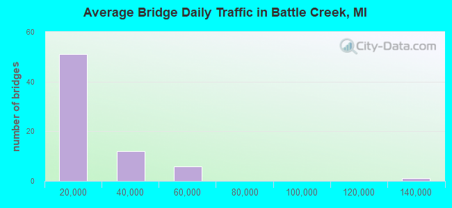
- 1,046,313Total average daily traffic
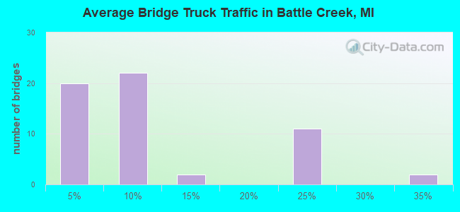
- 137,339Total average daily truck traffic
- National Bridge Inventory (NBI) Registered Bridges for Battle Creek
- No street view available for this location
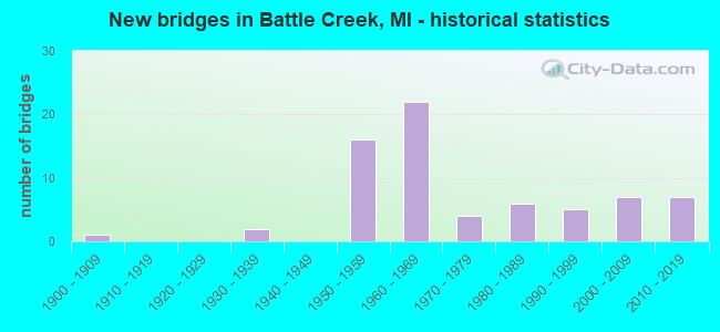
- New bridges - historical statistics
- 11900-1909
- 21930-1939
- 161950-1959
- 221960-1969
- 41970-1979
- 61980-1989
- 51990-1999
- 72000-2009
- 72010-2019
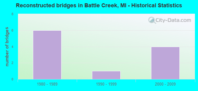
- Reconstructed bridges - Historical Statistics
- 61980-1989
- 11990-1999
- 42000-2009
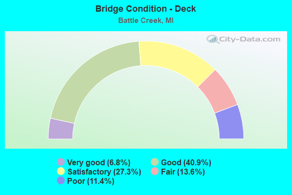
- Bridge Condition - Deck
- 6.8%Very good
- 40.9%Good
- 27.3%Satisfactory
- 13.6%Fair
- 11.4%Poor
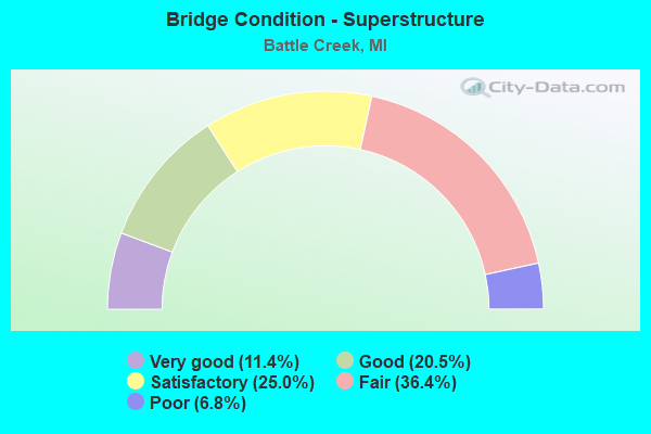
- Bridge Condition - Superstructure
- 11.4%Very good
- 20.5%Good
- 25.0%Satisfactory
- 36.4%Fair
- 6.8%Poor
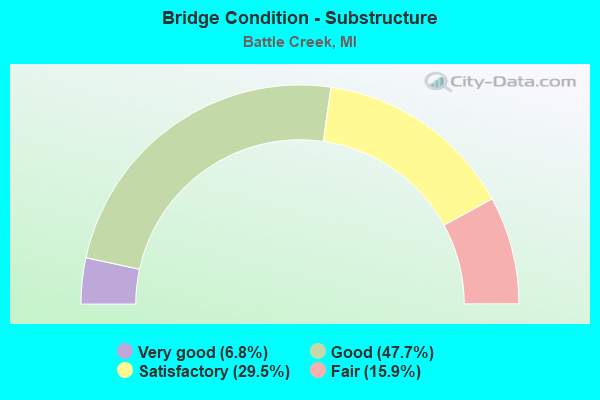
- Bridge Condition - Substructure
- 6.8%Very good
- 47.7%Good
- 29.5%Satisfactory
- 15.9%Fair
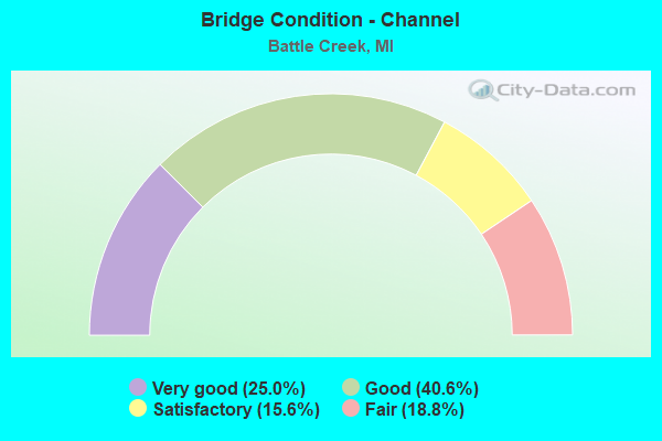
- Bridge Condition - Channel
- 25.0%Very good
- 40.6%Good
- 15.6%Satisfactory
- 18.8%Fair
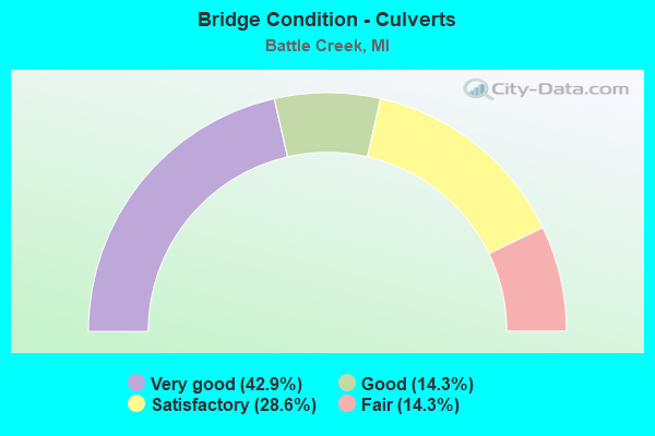
- Bridge Condition - Culverts
- 42.9%Very good
- 14.3%Good
- 28.6%Satisfactory
- 14.3%Fair
Find on map >> Show street view
Structure Number: 14, Location: 8 MI N OF M-72 (Lat: 44.773861, Lng: -83.521675), Route carried "on" structure: County highway 161, Year Built: 1936, Status: Open, Structure Length: 0.82m (2.69ft), Average Daily Traffic: 830 (year 2003), Average Future Daily Traffic: 1,125 (year 2023), Features Intersected: SUCKER CREEK, Facility Carried by Structure: HUBBARD LAKE ROAD
Minimum Vertical Clearance: 30.48m (100.00ft), Kilometerpoint: 21.510, Lanes on structure: 2, Owner: County Highway Agency, Approaching Roadway Width: 9.1m (29.9ft), Material/Design: Concrete, Design/Construction: Slab, Number Of Spans In Main Unit: 1, Length of Maximum Span: 7.9m (25.9ft), Curb-To-Curb Width: 10.1m (33.1ft), Out-to-Out Width: 10.1m (33.1ft)
Condition: Deck: Fair, Superstructure: Poor, Substructure: Fair, Channel: Fair, Operating Rating: 47.0 metric tons, Method Used To Determine Operating Rating: Field evaluation and documented engineering judgment, Inventory Rating: 28.1 metric tons, Method Used To Determine Inventory Rating: Field evaluation and documented engineering judgment, Structural Evaluation: Meets minimum limits, Deck Geometry: Equal to present minimum criteria, Waterway Adequacy: Meets minimum limits, Approach Roadway Alignment: Somewhat better than minimum adequacy, Length Of Structure Improvement: 1.65m (5.41ft), Designated Inspection Frequency: Every 24 months, Inspection Date: May 2021, Bridge Improvement Cost: $360,000, Roadway Improvement Cost: $100,000, Total Project Cost: $460,000, Deck Structure Type: Concrete Cast-file-Place, Wearing Surface/Protective System: Wearing Surface: Bituminous
Find on map >> Show street view
Structure Number: 125, Location: 1.3 MI SW OF OTTAWA COL (Lat: 42.747258, Lng: -86.066383), Route carried "on" structure: Interstate 196, Year Built: 1972, Status: Open, Structure Length: 4.26m (13.98ft), Average Daily Traffic: 9,123 (year 2007), Truck Traffic: 32%, Average Future Daily Traffic: 8,394 (year 2018), Design Load: HS 20+Mod, Features Intersected: CSX RR
Minimum Vertical Clearance: 30.48m (100.00ft), Kilometerpoint: 44.246, Lanes on structure: 3, Base Highway Network: Yes (Inventory Route: 78, Subroute: 7), Owner: State Highway Agency, Approaching Roadway Width: 12.3m (40.4ft), Material/Design: Prestressed concrete, Design/Construction: Stringer/Multi-beam, Number Of Spans In Main Unit: 3, Length of Maximum Span: 14.3m (46.9ft), Curb-To-Curb Width: 15.2m (49.9ft), Out-to-Out Width: 16.2m (53.1ft)
Condition: Deck: Satisfactory, Superstructure: Satisfactory, Substructure: Fair, Operating Rating: 71.0 metric tons, Method Used To Determine Operating Rating: Load Factor (LF) rating reported by rating factor (RF) method using MS18 loading, Inventory Rating: 39.9 metric tons, Method Used To Determine Inventory Rating: Load Factor (LF) rating reported by rating factor (RF) method using MS18 loading, Structural Evaluation: Somewhat better than minimum adequacy, Deck Geometry: Meets minimum limits, Approach Roadway Alignment: Equal to present desirable criteria, Designated Inspection Frequency: Every 24 months, Inspection Date: May 2021, Deck Structure Type: Concrete Cast-file-Place, Wearing Surface/Protective System: Wearing Surface: Monolithic Concrete
Find on map >> Show street view
Structure Number: 496, Location: 4.8 MI W OF MARQUETTE COL (Lat: 46.553564, Lng: -88.210167), Route carried "on" structure: US 41, Year Built: 1939, Status: Open, Structure Length: 1.07m (3.51ft), Average Daily Traffic: 2,625 (year 2020), Truck Traffic: 12%, Average Future Daily Traffic: 2,900 (year 2040), Design Load: H 20, Features Intersected: LAKE RUTH
Minimum Vertical Clearance: 30.48m (100.00ft), Kilometerpoint: 7.480, Lanes on structure: 2, Base Highway Network: Yes (Inventory Route: 118, Subroute: 7), Owner: State Highway Agency, Approaching Roadway Width: 12.2m (40.0ft), Material/Design: Steel, Design/Construction: Stringer/Multi-beam, Number Of Spans In Main Unit: 1, Length of Maximum Span: 10.2m (33.5ft), Curb-To-Curb Width: 11.2m (36.7ft), Out-to-Out Width: 12.2m (40.0ft)
Condition: Deck: Good, Superstructure: Satisfactory, Substructure: Satisfactory, Channel: Good, Operating Rating: 52.8 metric tons, Method Used To Determine Operating Rating: Load Factor (LF) rating reported by rating factor (RF) method using MS18 loading, Inventory Rating: 28.8 metric tons, Method Used To Determine Inventory Rating: Load Factor (LF) rating reported by rating factor (RF) method using MS18 loading, Structural Evaluation: Equal to present minimum criteria, Deck Geometry: Somewhat better than minimum adequacy, Waterway Adequacy: Better than present minimum criteria, Approach Roadway Alignment: Equal to present minimum criteria, Designated Inspection Frequency: Every 24 months, Inspection Date: July 2021, Deck Structure Type: Concrete Cast-file-Place, Wearing Surface/Protective System: Wearing Surface: Bituminous, Membrane: Preformed Fabric
Find on map >> Show street view
Structure Number: 1192, Location: 0.1 MI N OF I-94 BL (Lat: 42.320297, Lng: -85.192808), Route carried "on" structure: State highway 89, Year Built: 1982, Status: Open, Structure Length: 21.73m (71.29ft), Average Daily Traffic: 11,004 (year 2007), Truck Traffic: 2%, Average Future Daily Traffic: 20,031 (year 2018), Design Load: HS 20, Features Intersected: GTW RR & KALAMAZOO RIVER
Minimum Vertical Clearance: 30.48m (100.00ft), Kilometerpoint: 1.321, Lanes on structure: 4, Base Highway Network: Yes (Inventory Route: 129, Subroute: 6), Owner: State Highway Agency, Approaching Roadway Width: 15.8m (51.8ft), Material/Design: Steel continuous, Design/Construction: Stringer/Multi-beam, Number Of Spans In Main Unit: 8, Length of Maximum Span: 37.8m (124.0ft), Curb or Sidewalk Widths: Left: 1.8m (5.9ft), Right: 1.8m (5.9ft), Curb-To-Curb Width: 15.8m (51.8ft), Out-to-Out Width: 20.2m (66.3ft)
Condition: Deck: Satisfactory, Superstructure: Satisfactory, Substructure: Fair, Channel: Very good, Operating Rating: 42.1 metric tons, Method Used To Determine Operating Rating: Load and Resistance Factor Rating (LRFR) rating reported by rating factor(RF) method using HL-93 loadings, Inventory Rating: 32.7 metric tons, Method Used To Determine Inventory Rating: Load and Resistance Factor Rating (LRFR) rating reported by rating factor(RF) method using HL-93 loadings, Structural Evaluation: Somewhat better than minimum adequacy, Deck Geometry: Meets minimum limits, Underclear: Somewhat better than minimum adequacy, Waterway Adequacy: Superior to present desirable criteria, Approach Roadway Alignment: Equal to present desirable criteria, Designated Inspection Frequency: Every 24 months, Inspection Date: July 2021, Deck Structure Type: Concrete Cast-file-Place, Wearing Surface/Protective System: Wearing Surface: Latex Concrete, Deck Protection: Epoxy Coated Reinforcing
Find on map >> Show street view
Structure Number: 1198, Location: 3.2 MI SW OF BARRY COL (Lat: 42.396486, Lng: -85.131350), Route carried "on" structure: State highway 66, Year Built: 2012, Status: Open, Structure Length: 2.01m (6.59ft), Average Daily Traffic: 8,121 (year 2011), Truck Traffic: 5%, Average Future Daily Traffic: 8,108 (year 2031), Design Load: HL 93, Features Intersected: WANADOGA CREEK
Minimum Vertical Clearance: 30.48m (100.00ft), Kilometerpoint: 10.451, Lanes on structure: 2, Base Highway Network: Yes (Inventory Route: 313, Subroute: 86), Owner: State Highway Agency, Approaching Roadway Width: 13.3m (43.6ft), Material/Design: Prestressed concrete, Design/Construction: Box Beam or Girders - Single/Spread, Number Of Spans In Main Unit: 1, Length of Maximum Span: 19.2m (63.0ft), Curb-To-Curb Width: 13.5m (44.3ft), Out-to-Out Width: 14.2m (46.6ft)
Condition: Deck: Good, Superstructure: Very good, Substructure: Good, Channel: Fair, Operating Rating: 59.6 metric tons, Method Used To Determine Operating Rating: Load and Resistance Factor Rating (LRFR) rating reported by rating factor(RF) method using HL-93 loadings, Inventory Rating: 38.6 metric tons, Method Used To Determine Inventory Rating: Load and Resistance Factor Rating (LRFR) rating reported by rating factor(RF) method using HL-93 loadings, Structural Evaluation: Better than present minimum criteria, Deck Geometry: Superior to present desirable criteria, Waterway Adequacy: Equal to present desirable criteria, Approach Roadway Alignment: Equal to present desirable criteria, Designated Inspection Frequency: Every 24 months, Inspection Date: September 2021, Deck Structure Type: Concrete Cast-file-Place, Wearing Surface/Protective System: Wearing Surface: Monolithic Concrete, Deck Protection: Epoxy Coated Reinforcing
Find on map >> Show street view
Structure Number: 12, Location: 2.5 MI N OF I-94 (Lat: 42.304331, Lng: -85.183642), Route carried "on" structure: Interstate 194, Year Built: 1966, Status: Open, Structure Length: 11.33m (37.17ft), Average Daily Traffic: 24,600 (year 2013), Truck Traffic: 5%, Average Future Daily Traffic: 28,600 (year 2033), Design Load: HS 20+Mod, Features Intersected: KALAMAZOO RIVER
Minimum Vertical Clearance: 30.48m (100.00ft), Kilometerpoint: 5.718, Lanes on structure: 5, Base Highway Network: Yes (Inventory Route: 129, Subroute: 2), Owner: State Highway Agency, Approaching Roadway Width: 26.5m (86.9ft), Skew: 35 degrees, Material/Design: Steel continuous, Design/Construction: Stringer/Multi-beam, Number Of Spans In Main Unit: 5, Length of Maximum Span: 23.4m (76.8ft), Curb-To-Curb Width: 24.7m (81.0ft), Out-to-Out Width: 26.5m (86.9ft)
Condition: Deck: Satisfactory, Superstructure: Fair, Substructure: Fair, Channel: Fair, Operating Rating: 66.4 metric tons, Method Used To Determine Operating Rating: Load Factor (LF) rating reported by rating factor (RF) method using MS18 loading, Inventory Rating: 39.9 metric tons, Method Used To Determine Inventory Rating: Load Factor (LF) rating reported by rating factor (RF) method using MS18 loading, Structural Evaluation: Somewhat better than minimum adequacy, Deck Geometry: Better than present minimum criteria, Waterway Adequacy: Equal to present desirable criteria, Approach Roadway Alignment: Better than present minimum criteria, Designated Inspection Frequency: Every 24 months, Underwater Inspection Frequency: Every 60 months, Inspection Date: July 2021, Underwater Inspection Date: August 2017, Deck Structure Type: Concrete Cast-file-Place, Wearing Surface/Protective System: Wearing Surface: Latex Concrete
Find on map >> Show street view
Structure Number: 1207, Location: 2.1 MI N OF I-94 (Lat: 42.298489, Lng: -85.180297), Route carried "on" structure: State highway 96, Year Built: 1965, Status: Open, Structure Length: 5.00m (16.40ft), Average Daily Traffic: 20,478 (year 2007), Truck Traffic: 34%, Average Future Daily Traffic: 25,600 (year 2027), Design Load: HS 20, Features Intersected: I-194
Minimum Vertical Clearance: 30.48m (100.00ft), Kilometerpoint: 8.329, Lanes on structure: 5, Lanes under structure: 4, Base Highway Network: Yes (Inventory Route: 129, Subroute: 9), Owner: State Highway Agency, Approaching Roadway Width: 21.9m (71.9ft), Skew: 21 degrees, Material/Design: Steel, Design/Construction: Stringer/Multi-beam, Number Of Spans In Main Unit: 3, Length of Maximum Span: 28.2m (92.5ft), Curb or Sidewalk Widths: Left: 0.2m (0.7ft), Right: 0.2m (0.7ft), Curb-To-Curb Width: 21.0m (68.9ft), Out-to-Out Width: 23.9m (78.4ft)
Condition: Deck: Satisfactory, Superstructure: Fair, Substructure: Good, Operating Rating: 58.6 metric tons, Method Used To Determine Operating Rating: Load Factor (LF) rating reported by rating factor (RF) method using MS18 loading, Inventory Rating: 35.0 metric tons, Method Used To Determine Inventory Rating: Load Factor (LF) rating reported by rating factor (RF) method using MS18 loading, Structural Evaluation: Somewhat better than minimum adequacy, Deck Geometry: Somewhat better than minimum adequacy, Underclear: High priority of corrective action, Approach Roadway Alignment: Equal to present desirable criteria, Designated Inspection Frequency: Every 24 months, Inspection Date: September 2021, Bridge Improvement Cost: $177,000, Deck Structure Type: Concrete Cast-file-Place, Wearing Surface/Protective System: Wearing Surface: Monolithic Concrete
Find on map >> Show street view
Structure Number: 1208, Location: 2.8 MI N OF I-94 (Lat: 42.308644, Lng: -85.185014), Route carried "on" structure: Interstate 194, Year Built: 1966, Status: Open, Structure Length: 4.05m (13.29ft), Average Daily Traffic: 24,406 (year 2007), Truck Traffic: 6%, Average Future Daily Traffic: 27,685 (year 2018), Design Load: HS 20, Features Intersected: BURNHAM ST
Minimum Vertical Clearance: 30.48m (100.00ft), Kilometerpoint: 6.153, Lanes on structure: 6, Lanes under structure: 2, Base Highway Network: Yes (Inventory Route: 129, Subroute: 2), Owner: State Highway Agency, Approaching Roadway Width: 28.9m (94.8ft), Skew: 32 degrees, Material/Design: Prestressed concrete, Design/Construction: Stringer/Multi-beam, Number Of Spans In Main Unit: 3, Length of Maximum Span: 20.7m (67.9ft), Curb-To-Curb Width: 27.6m (90.6ft), Out-to-Out Width: 29.8m (97.8ft)
Condition: Deck: Satisfactory, Superstructure: Fair, Substructure: Fair, Operating Rating: 87.8 metric tons, Method Used To Determine Operating Rating: Load Factor (LF) rating reported by rating factor (RF) method using MS18 loading, Inventory Rating: 48.6 metric tons, Method Used To Determine Inventory Rating: Load Factor (LF) rating reported by rating factor (RF) method using MS18 loading, Structural Evaluation: Somewhat better than minimum adequacy, Deck Geometry: Equal to present minimum criteria, Underclear: Somewhat better than minimum adequacy, Approach Roadway Alignment: Equal to present desirable criteria, Designated Inspection Frequency: Every 24 months, Inspection Date: September 2021, Deck Structure Type: Concrete Cast-file-Place, Wearing Surface/Protective System: Wearing Surface: Monolithic Concrete
Find on map >> Show street view
Structure Number: 1209, Location: 3.1 MI N OF I-94 (Lat: 42.311847, Lng: -85.182014), Route carried "on" structure: Interstate 194, Year Built: 1966, Status: Open, Structure Length: 8.62m (28.28ft), Average Daily Traffic: 24,600 (year 2013), Truck Traffic: 5%, Average Future Daily Traffic: 28,600 (year 2030), Design Load: HS 20+Mod, Features Intersected: I-94 BL (DICKMAN ROAD)
Minimum Vertical Clearance: 30.48m (100.00ft), Kilometerpoint: 6.574, Lanes on structure: 5, Lanes under structure: 4, Base Highway Network: Yes (Inventory Route: 129, Subroute: 2), Owner: State Highway Agency, Approaching Roadway Width: 24.3m (79.7ft), Skew: 33 degrees, Material/Design: Steel, Design/Construction: Stringer/Multi-beam, Number Of Spans In Main Unit: 4, Length of Maximum Span: 22.2m (72.8ft), Curb-To-Curb Width: 23.9m (78.4ft), Out-to-Out Width: 26.6m (87.3ft)
Condition: Deck: Satisfactory, Superstructure: Fair, Substructure: Satisfactory, Operating Rating: 64.2 metric tons, Method Used To Determine Operating Rating: Load Factor (LF) rating reported by rating factor (RF) method using MS18 loading, Inventory Rating: 38.6 metric tons, Method Used To Determine Inventory Rating: Load Factor (LF) rating reported by rating factor (RF) method using MS18 loading, Structural Evaluation: Somewhat better than minimum adequacy, Deck Geometry: Equal to present minimum criteria, Underclear: Meets minimum limits, Approach Roadway Alignment: Equal to present desirable criteria, Designated Inspection Frequency: Every 24 months, Inspection Date: September 2021, Deck Structure Type: Concrete Cast-file-Place, Wearing Surface/Protective System: Wearing Surface: Latex Concrete
Find on map >> Show street view
Structure Number: 121, Location: 3.3 MI N OF I-94 (Lat: 42.314389, Lng: -85.180867), Route carried "on" structure: Interstate 194, Year Built: 1966, Year Reconstructed: 2013, Status: Open, Structure Length: 4.23m (13.88ft), Average Daily Traffic: 21,000 (year 2013), Truck Traffic: 5%, Average Future Daily Traffic: 24,000 (year 2033), Design Load: HS 20+Mod, Features Intersected: FOUNTAIN STREET
Minimum Vertical Clearance: 30.48m (100.00ft), Kilometerpoint: 6.890, Lanes on structure: 5, Lanes under structure: 2, Base Highway Network: Yes (Inventory Route: 129, Subroute: 2), Owner: State Highway Agency, Approaching Roadway Width: 27.1m (88.9ft), Skew: 31 degrees, Material/Design: Steel, Design/Construction: Stringer/Multi-beam, Number Of Spans In Main Unit: 3, Length of Maximum Span: 21.9m (71.9ft), Curb-To-Curb Width: 25.9m (85.0ft), Out-to-Out Width: 28.1m (92.2ft)
Condition: Deck: Satisfactory, Superstructure: Fair, Substructure: Good, Operating Rating: 64.8 metric tons, Method Used To Determine Operating Rating: Load Factor (LF) rating reported by rating factor (RF) method using MS18 loading, Inventory Rating: 38.9 metric tons, Method Used To Determine Inventory Rating: Load Factor (LF) rating reported by rating factor (RF) method using MS18 loading, Structural Evaluation: Somewhat better than minimum adequacy, Deck Geometry: Superior to present desirable criteria, Underclear: Equal to present minimum criteria, Approach Roadway Alignment: Equal to present desirable criteria, Designated Inspection Frequency: Every 24 months, Inspection Date: September 2021, Deck Structure Type: Concrete Cast-file-Place, Wearing Surface/Protective System: Wearing Surface: Latex Concrete, Deck Protection: Epoxy Coated Reinforcing
Find on map >> Show street view
Structure Number: 1248, Location: 0.1 MI E OF KALAMAZOO COL (Lat: 42.272683, Lng: -85.295483), Route carried "on" structure: Business Interstate 94, Year Built: 2015, Status: Open, Structure Length: 7.82m (25.66ft), Average Daily Traffic: 121,987 (year 2015), Truck Traffic: 9%, Average Future Daily Traffic: 14,350 (year 2035), Design Load: Greater than HL93, Features Intersected: I-94
Minimum Vertical Clearance: 30.48m (100.00ft), Kilometerpoint: 0.100, Lanes on structure: 3, Lanes under structure: 5, Base Highway Network: Yes (Inventory Route: 129, Subroute: 7), Owner: State Highway Agency, Approaching Roadway Width: 12.8m (42.0ft), Skew: 3 degrees, Material/Design: Prestressed concrete, Design/Construction: Stringer/Multi-beam, Number Of Spans In Main Unit: 2, Length of Maximum Span: 38.8m (127.3ft), Curb or Sidewalk Widths: Left: 0.0m, Right: 4.3m (14.1ft), Curb-To-Curb Width: 17.8m (58.4ft), Out-to-Out Width: 23.1m (75.8ft)
Condition: Deck: Good, Superstructure: Satisfactory, Substructure: Good, Operating Rating: 59.6 metric tons, Method Used To Determine Operating Rating: Load and Resistance Factor Rating (LRFR) rating reported by rating factor(RF) method using HL-93 loadings, Inventory Rating: 35.3 metric tons, Method Used To Determine Inventory Rating: Load and Resistance Factor Rating (LRFR) rating reported by rating factor(RF) method using HL-93 loadings, Structural Evaluation: Equal to present minimum criteria, Deck Geometry: Better than present minimum criteria, Underclear: Equal to present minimum criteria, Approach Roadway Alignment: Equal to present desirable criteria, Designated Inspection Frequency: Every 24 months, Inspection Date: September 2021, Deck Structure Type: Concrete Cast-file-Place, Wearing Surface/Protective System: Wearing Surface: Monolithic Concrete, Deck Protection: Epoxy Coated Reinforcing
Find on map >> Show street view
Structure Number: 125, Location: 3.0 MI E OF KALAMAZOO COL (Lat: 42.265300, Lng: -85.237953), Route carried "on" structure: City street 2011, Year Built: 1959, Status: Open, Structure Length: 7.81m (25.62ft), Average Daily Traffic: 3,000 (year 1974), Average Future Daily Traffic: 3,000 (year 1977), Design Load: H 20, Features Intersected: I-94, Facility Carried by Structure: HELMER ROAD
Minimum Vertical Clearance: 30.48m (100.00ft), Kilometerpoint: 2.055, Lanes on structure: 2, Lanes under structure: 4, Owner: State Highway Agency, Approaching Roadway Width: 11.9m (39.0ft), Material/Design: Concrete continuous, Design/Construction: Tee Beam, Number Of Spans In Main Unit: 4, Length of Maximum Span: 22.6m (74.1ft), Curb or Sidewalk Widths: Left: 1.2m (3.9ft), Right: 1.2m (3.9ft), Curb-To-Curb Width: 7.9m (25.9ft), Out-to-Out Width: 11.1m (36.4ft)
Condition: Deck: Fair, Superstructure: Fair, Substructure: Satisfactory, Operating Rating: 55.1 metric tons, Method Used To Determine Operating Rating: Load Factor (LF) rating reported by rating factor (RF) method using MS18 loading, Inventory Rating: 33.0 metric tons, Method Used To Determine Inventory Rating: Load Factor (LF) rating reported by rating factor (RF) method using MS18 loading, Structural Evaluation: Somewhat better than minimum adequacy, Deck Geometry: High priority of corrective action, Underclear: Meets minimum limits, Approach Roadway Alignment: Equal to present desirable criteria, Designated Inspection Frequency: Every 24 months, Inspection Date: September 2021, Deck Structure Type: Concrete Cast-file-Place, Wearing Surface/Protective System: Wearing Surface: Latex Concrete
Find on map >> Show street view
Structure Number: 1251, Location: 5.0 MI E OF KALAMAZOO COL (Lat: 42.261836, Lng: -85.198592), Route carried "on" structure: City street , Year Built: 1959, Year Reconstructed: 1992, Status: Open, Structure Length: 7.82m (25.66ft), Average Daily Traffic: 29,500 (year 1990), Average Future Daily Traffic: 29,500 (year 2015), Design Load: HS 25 or greater, Features Intersected: I-94, Facility Carried by Structure: CAPITAL AVE
Minimum Vertical Clearance: 30.48m (100.00ft), Kilometerpoint: 3.320, Lanes on structure: 5, Lanes under structure: 4, Owner: State Highway Agency, Approaching Roadway Width: 18.0m (59.1ft), Material/Design: Prestressed concrete, Design/Construction: Box Beam or Girders - Multiple, Number Of Spans In Main Unit: 4, Length of Maximum Span: 23.6m (77.4ft), Curb or Sidewalk Widths: Left: 2.4m (7.9ft), Right: 2.4m (7.9ft), Curb-To-Curb Width: 18.0m (59.1ft), Out-to-Out Width: 23.6m (77.4ft)
Condition: Deck: Poor, Superstructure: Poor, Substructure: Satisfactory, Operating Rating: 53.1 metric tons, Method Used To Determine Operating Rating: Load Factor (LF) rating reported by rating factor (RF) method using MS18 loading, Inventory Rating: 31.8 metric tons, Method Used To Determine Inventory Rating: Load Factor (LF) rating reported by rating factor (RF) method using MS18 loading, Structural Evaluation: Meets minimum limits, Deck Geometry: High priority of replacement, Underclear: High priority of corrective action, Approach Roadway Alignment: Equal to present desirable criteria, Designated Inspection Frequency: Every 24 months, Other Special Inspection Frequency: Every 18 months, Inspection Date: September 2021, Other Special Inspection Date: March 2021, Deck Structure Type: Concrete Cast-file-Place, Wearing Surface/Protective System: Wearing Surface: Latex Concrete, Deck Protection: Epoxy Coated Reinforcing
Find on map >> Show street view
Structure Number: 1252, Location: 0.5 MI W OF M-66 (Lat: 42.262864, Lng: -85.188875), Route carried "on" structure: Interstate 94, Year Built: 2009, Status: Open, Structure Length: 2.11m (6.92ft), Average Daily Traffic: 27,324 (year 2007), Truck Traffic: 23%, Average Future Daily Traffic: 78,600 (year 2029), Design Load: Greater than HL93, Features Intersected: RIVERSIDE DRIVE
Minimum Vertical Clearance: 30.48m (100.00ft), Kilometerpoint: 9.079, Lanes on structure: 2, Lanes under structure: 3, Base Highway Network: Yes (Inventory Route: 129, Subroute: 6), Owner: State Highway Agency, Approaching Roadway Width: 18.3m (60.0ft), Skew: 2 degrees, Material/Design: Prestressed concrete, Design/Construction: Box Beam or Girders - Single/Spread, Number Of Spans In Main Unit: 1, Length of Maximum Span: 18.3m (60.0ft), Curb-To-Curb Width: 18.5m (60.7ft), Out-to-Out Width: 19.4m (63.6ft)
Condition: Deck: Good, Superstructure: Satisfactory, Substructure: Good, Operating Rating: 91.1 metric tons, Method Used To Determine Operating Rating: Load Factor (LF), Inventory Rating: 42.0 metric tons, Method Used To Determine Inventory Rating: Load Factor (LF), Structural Evaluation: Equal to present minimum criteria, Deck Geometry: Superior to present desirable criteria, Underclear: Somewhat better than minimum adequacy, Approach Roadway Alignment: Equal to present desirable criteria, Designated Inspection Frequency: Every 24 months, Inspection Date: September 2021, Deck Structure Type: Concrete Cast-file-Place, Wearing Surface/Protective System: Wearing Surface: Monolithic Concrete, Deck Protection: Other
Find on map >> Show street view
Structure Number: 1253, Location: 0.5 MI W OF M-66 (Lat: 42.263153, Lng: -85.188878), Route carried "on" structure: Interstate 94, Year Built: 2009, Status: Open, Structure Length: 2.11m (6.92ft), Average Daily Traffic: 27,324 (year 2007), Truck Traffic: 23%, Average Future Daily Traffic: 78,600 (year 2029), Design Load: Greater than HL93, Features Intersected: RIVERSIDE DRIVE
Minimum Vertical Clearance: 30.48m (100.00ft), Kilometerpoint: 9.080, Lanes on structure: 2, Lanes under structure: 3, Base Highway Network: Yes (Inventory Route: 129, Subroute: 9), Owner: State Highway Agency, Approaching Roadway Width: 18.3m (60.0ft), Skew: 2 degrees, Material/Design: Prestressed concrete, Design/Construction: Box Beam or Girders - Single/Spread, Number Of Spans In Main Unit: 1, Length of Maximum Span: 18.3m (60.0ft), Curb-To-Curb Width: 18.5m (60.7ft), Out-to-Out Width: 19.4m (63.6ft)
Condition: Deck: Good, Superstructure: Satisfactory, Substructure: Good, Operating Rating: 86.3 metric tons, Method Used To Determine Operating Rating: Load Factor (LF), Inventory Rating: 41.3 metric tons, Method Used To Determine Inventory Rating: Load Factor (LF), Structural Evaluation: Equal to present minimum criteria, Deck Geometry: Superior to present desirable criteria, Underclear: Equal to present minimum criteria, Approach Roadway Alignment: Equal to present desirable criteria, Designated Inspection Frequency: Every 24 months, Inspection Date: September 2021, Deck Structure Type: Concrete Cast-file-Place, Wearing Surface/Protective System: Wearing Surface: Monolithic Concrete, Deck Protection: Other
Find on map >> Show street view
Structure Number: 1254, Location: AT M-66 (Lat: 42.268489, Lng: -85.178483), Route carried "on" structure: Interstate 194, Year Built: 1960, Year Reconstructed: 1994, Status: Open, Structure Length: 11.06m (36.29ft), Average Daily Traffic: 10,341 (year 2007), Truck Traffic: 4%, Average Future Daily Traffic: 35,000 (year 2029), Design Load: HS 25 or greater, Features Intersected: I-94
Minimum Vertical Clearance: 30.48m (100.00ft), Kilometerpoint: 1.535, Lanes on structure: 3, Lanes under structure: 6, Base Highway Network: Yes (Inventory Route: 129, Subroute: 2), Owner: State Highway Agency, Approaching Roadway Width: 16.8m (55.1ft), Skew: 4 degrees, Material/Design: Steel continuous, Design/Construction: Stringer/Multi-beam, Number Of Spans In Main Unit: 4, Length of Maximum Span: 34.4m (112.9ft), Curb-To-Curb Width: 16.5m (54.1ft), Out-to-Out Width: 17.5m (57.4ft)
Condition: Deck: Good, Superstructure: Satisfactory, Substructure: Good, Operating Rating: 68.0 metric tons, Method Used To Determine Operating Rating: Load Factor (LF) rating reported by rating factor (RF) method using MS18 loading, Inventory Rating: 40.8 metric tons, Method Used To Determine Inventory Rating: Load Factor (LF) rating reported by rating factor (RF) method using MS18 loading, Structural Evaluation: Equal to present minimum criteria, Deck Geometry: Equal to present minimum criteria, Underclear: High priority of corrective action, Approach Roadway Alignment: Equal to present desirable criteria, Designated Inspection Frequency: Every 24 months, Inspection Date: August 2021, Deck Structure Type: Concrete Cast-file-Place, Wearing Surface/Protective System: Wearing Surface: Epoxy Overlay, Deck Protection: Epoxy Coated Reinforcing
Find on map >> Show street view
Structure Number: 1255, Location: AT M-66 (Lat: 42.268228, Lng: -85.178925), Route carried "on" structure: Interstate 194, Year Built: 1960, Year Reconstructed: 1994, Status: Open, Structure Length: 11.06m (36.29ft), Average Daily Traffic: 10,341 (year 2007), Truck Traffic: 4%, Average Future Daily Traffic: 35,000 (year 2029), Design Load: HS 25 or greater, Features Intersected: I-94
Minimum Vertical Clearance: 30.48m (100.00ft), Kilometerpoint: 1.498, Lanes on structure: 3, Lanes under structure: 6, Base Highway Network: Yes (Inventory Route: 130, Subroute: 10), Owner: State Highway Agency, Approaching Roadway Width: 16.5m (54.1ft), Skew: 4 degrees, Material/Design: Steel continuous, Design/Construction: Stringer/Multi-beam, Number Of Spans In Main Unit: 4, Length of Maximum Span: 34.4m (112.9ft), Curb-To-Curb Width: 16.5m (54.1ft), Out-to-Out Width: 17.5m (57.4ft)
Condition: Deck: Good, Superstructure: Satisfactory, Substructure: Good, Operating Rating: 68.4 metric tons, Method Used To Determine Operating Rating: Load Factor (LF) rating reported by rating factor (RF) method using MS18 loading, Inventory Rating: 40.8 metric tons, Method Used To Determine Inventory Rating: Load Factor (LF) rating reported by rating factor (RF) method using MS18 loading, Structural Evaluation: Equal to present minimum criteria, Deck Geometry: Equal to present minimum criteria, Underclear: High priority of corrective action, Approach Roadway Alignment: Equal to present desirable criteria, Designated Inspection Frequency: Every 24 months, Inspection Date: August 2021, Bridge Improvement Cost: $609,000, Deck Structure Type: Concrete Cast-file-Place, Wearing Surface/Protective System: Wearing Surface: Epoxy Overlay, Deck Protection: Epoxy Coated Reinforcing
Find on map >> Show street view
Structure Number: 1262, Location: 0.5 MI E OF M-66 (Lat: 42.273847, Lng: -85.169339), Route carried "on" structure: Interstate 94, Year Built: 1959, Status: Open, Structure Length: 4.73m (15.52ft), Average Daily Traffic: 22,400 (year 2010), Truck Traffic: 23%, Average Future Daily Traffic: 24,300 (year 2030), Design Load: HS 20, Features Intersected: 6 1/2 MILE ROAD
Minimum Vertical Clearance: 30.48m (100.00ft), Kilometerpoint: 11.087, Lanes on structure: 2, Lanes under structure: 2, Base Highway Network: Yes (Inventory Route: 129, Subroute: 9), Owner: State Highway Agency, Approaching Roadway Width: 11.7m (38.4ft), Skew: 3 degrees, Material/Design: Concrete continuous, Design/Construction: Tee Beam, Number Of Spans In Main Unit: 3, Length of Maximum Span: 18.5m (60.7ft), Curb-To-Curb Width: 12.8m (42.0ft), Out-to-Out Width: 14.4m (47.2ft)
Condition: Deck: Poor, Superstructure: Fair, Substructure: Satisfactory, Operating Rating: 52.8 metric tons, Method Used To Determine Operating Rating: Load Factor (LF) rating reported by rating factor (RF) method using MS18 loading, Inventory Rating: 31.8 metric tons, Method Used To Determine Inventory Rating: Load Factor (LF) rating reported by rating factor (RF) method using MS18 loading, Structural Evaluation: Somewhat better than minimum adequacy, Deck Geometry: Equal to present desirable criteria, Underclear: Somewhat better than minimum adequacy, Approach Roadway Alignment: Equal to present desirable criteria, Designated Inspection Frequency: Every 24 months, Other Special Inspection Frequency: Every 24 months, Inspection Date: August 2021, Other Special Inspection Date: August 2020, Deck Structure Type: Concrete Cast-file-Place, Wearing Surface/Protective System: Wearing Surface: Latex Concrete
Find on map >> Show street view
Structure Number: 1263, Location: 1.5 MI E OF M-66 (Lat: 42.281428, Lng: -85.155889), Route carried "on" structure: Interstate 94, Year Built: 1959, Status: Open, Structure Length: 3.71m (12.17ft), Average Daily Traffic: 22,400 (year 2010), Truck Traffic: 23%, Average Future Daily Traffic: 24,300 (year 2030), Design Load: HS 20, Features Intersected: M-294 BEADLE LAKE
Minimum Vertical Clearance: 30.48m (100.00ft), Kilometerpoint: 12.499, Lanes on structure: 2, Lanes under structure: 2, Base Highway Network: Yes (Inventory Route: 129, Subroute: 6), Owner: State Highway Agency, Approaching Roadway Width: 11.7m (38.4ft), Skew: 2 degrees, Material/Design: Concrete, Design/Construction: Tee Beam, Number Of Spans In Main Unit: 3, Length of Maximum Span: 13.4m (44.0ft), Curb-To-Curb Width: 12.8m (42.0ft), Out-to-Out Width: 14.3m (46.9ft)
Condition: Deck: Fair, Superstructure: Fair, Substructure: Satisfactory, Operating Rating: 61.4 metric tons, Method Used To Determine Operating Rating: Load Factor (LF), Inventory Rating: 36.8 metric tons, Method Used To Determine Inventory Rating: Load Factor (LF), Structural Evaluation: Somewhat better than minimum adequacy, Deck Geometry: Equal to present desirable criteria, Underclear: Meets minimum limits, Approach Roadway Alignment: Equal to present desirable criteria, Designated Inspection Frequency: Every 24 months, Inspection Date: August 2021, Deck Structure Type: Concrete Cast-file-Place, Wearing Surface/Protective System: Wearing Surface: Latex Concrete
Find on map >> Show street view
Structure Number: 1264, Location: 1.5 MI E OF M-66 (Lat: 42.281708, Lng: -85.155994), Route carried "on" structure: Interstate 94, Year Built: 1959, Status: Open, Structure Length: 3.71m (12.17ft), Average Daily Traffic: 22,400 (year 2010), Truck Traffic: 23%, Average Future Daily Traffic: 24,300 (year 2030), Design Load: HS 20, Features Intersected: M-294 BEADLE LAKE
Minimum Vertical Clearance: 30.48m (100.00ft), Kilometerpoint: 12.492, Lanes on structure: 2, Lanes under structure: 2, Base Highway Network: Yes (Inventory Route: 129, Subroute: 9), Owner: State Highway Agency, Approaching Roadway Width: 11.7m (38.4ft), Skew: 2 degrees, Material/Design: Concrete, Design/Construction: Tee Beam, Number Of Spans In Main Unit: 3, Length of Maximum Span: 13.4m (44.0ft), Curb-To-Curb Width: 12.8m (42.0ft), Out-to-Out Width: 14.3m (46.9ft)
Condition: Deck: Fair, Superstructure: Fair, Substructure: Satisfactory, Operating Rating: 61.4 metric tons, Method Used To Determine Operating Rating: Load Factor (LF), Inventory Rating: 36.8 metric tons, Method Used To Determine Inventory Rating: Load Factor (LF), Structural Evaluation: Somewhat better than minimum adequacy, Deck Geometry: Equal to present desirable criteria, Underclear: Meets minimum limits, Approach Roadway Alignment: Equal to present desirable criteria, Designated Inspection Frequency: Every 24 months, Inspection Date: August 2021, Deck Structure Type: Concrete Cast-file-Place, Wearing Surface/Protective System: Wearing Surface: Latex Concrete
Find on map >> Show street view
Structure Number: 1291, Location: 0.1 MI W OF I-194 (Lat: 42.311872, Lng: -85.185439), Route carried "on" structure: Business Interstate 94, Year Built: 1963, Status: Open, Structure Length: 3.47m (11.38ft), Average Daily Traffic: 11,158 (year 2007), Truck Traffic: 6%, Average Future Daily Traffic: 14,660 (year 2018), Design Load: HS 20+Mod, Features Intersected: KALAMAZOO RIVER
Minimum Vertical Clearance: 30.48m (100.00ft), Kilometerpoint: 10.762, Lanes on structure: 5, Base Highway Network: Yes (Inventory Route: 129, Subroute: 8), Owner: State Highway Agency, Approaching Roadway Width: 21.9m (71.9ft), Skew: 20 degrees, Material/Design: Steel, Design/Construction: Culvert, Number Of Spans In Main Unit: 8, Length of Maximum Span: 4.2m (13.8ft)
Condition: Channel: Good, Culverts: Satisfactory, Operating Rating: 97.2 metric tons, Method Used To Determine Operating Rating: Load Factor (LF) rating reported by rating factor (RF) method using MS18 loading, Inventory Rating: 97.2 metric tons, Method Used To Determine Inventory Rating: Load Factor (LF) rating reported by rating factor (RF) method using MS18 loading, Structural Evaluation: Equal to present minimum criteria, Waterway Adequacy: Better than present minimum criteria, Approach Roadway Alignment: Equal to present minimum criteria, Designated Inspection Frequency: Every 24 months, Inspection Date: March 2021, Wearing Surface/Protective System: Wearing Surface: Bituminous
Find on map >> Show street view
Structure Number: 1306, Location: EMMETT TWP SEC 18 (Lat: 42.293781, Lng: -85.168311), Route carried "on" structure: County highway 2011, Year Built: 1971, Status: Posted for load, Structure Length: 1.09m (3.58ft), Average Daily Traffic: 2,476 (year 1995), Truck Traffic: 9%, Average Future Daily Traffic: 4,431 (year 2023), Features Intersected: MINGES CREEK, Facility Carried by Structure: GOLDEN AVE
Minimum Vertical Clearance: 30+ m (98+ ft), Kilometerpoint: 2.553, Lanes on structure: 2, Owner: County Highway Agency, Approaching Roadway Width: 12.2m (40.0ft), Material/Design: Wood or Timber, Design/Construction: Slab, Number Of Spans In Main Unit: 2, Length of Maximum Span: 5.4m (17.7ft), Curb-To-Curb Width: 9.1m (29.9ft), Out-to-Out Width: 9.6m (31.5ft)
Condition: Deck: Fair, Superstructure: Fair, Substructure: Satisfactory, Channel: Good, Operating Rating: 20.2 metric tons, Method Used To Determine Operating Rating: Allowable Stress (AS), Inventory Rating: 14.2 metric tons, Method Used To Determine Inventory Rating: Allowable Stress (AS), Structural Evaluation: Meets minimum limits, Deck Geometry: Meets minimum limits, Waterway Adequacy: Equal to present desirable criteria, Approach Roadway Alignment: Equal to present desirable criteria, Bridge Posting: Required (Relationship of Operating Rating to Maximum Legal Load: > 39.9% below), Designated Inspection Frequency: Every 12 months, Inspection Date: September 2021, Deck Structure Type: Wood or Timber, Wearing Surface/Protective System: Wearing Surface: Bituminous
Find on map >> Show street view
Structure Number: 1309, Location: 1.9 MI E OF I-194 (Lat: 42.309681, Lng: -85.145322), Route carried "on" structure: State highway 96, Year Built: 2014, Status: Open, Structure Length: 1.77m (5.81ft), Average Daily Traffic: 11,200 (year 2014), Truck Traffic: 4%, Average Future Daily Traffic: 13,000 (year 2034), Design Load: Greater than HL93, Features Intersected: RAYMOND RD
Minimum Vertical Clearance: 30.48m (100.00ft), Kilometerpoint: 11.509, Lanes on structure: 3, Lanes under structure: 2, Base Highway Network: Yes (Inventory Route: 129, Subroute: 9), Owner: State Highway Agency, Approaching Roadway Width: 17.1m (56.1ft), Skew: 1 degrees, Material/Design: Concrete, Design/Construction: Box Beam or Girders - Single/Spread, Number Of Spans In Main Unit: 1, Length of Maximum Span: 16.8m (55.1ft), Curb-To-Curb Width: 17.1m (56.1ft), Out-to-Out Width: 18.0m (59.1ft)
Condition: Deck: Good, Superstructure: Very good, Substructure: Good, Operating Rating: 53.1 metric tons, Method Used To Determine Operating Rating: Load and Resistance Factor Rating (LRFR) rating reported by rating factor(RF) method using HL-93 loadings, Inventory Rating: 40.8 metric tons, Method Used To Determine Inventory Rating: Load and Resistance Factor Rating (LRFR) rating reported by rating factor(RF) method using HL-93 loadings, Structural Evaluation: Better than present minimum criteria, Deck Geometry: Superior to present desirable criteria, Underclear: Equal to present minimum criteria, Approach Roadway Alignment: Better than present minimum criteria, Designated Inspection Frequency: Every 24 months, Inspection Date: August 2021, Deck Structure Type: Concrete Cast-file-Place, Wearing Surface/Protective System: Wearing Surface: Monolithic Concrete, Deck Protection: Epoxy Coated Reinforcing
Find on map >> Show street view
Structure Number: 1311, Location: PENNFIELD TWP SEC 21 (Lat: 42.369997, Lng: -85.128856), Route carried "on" structure: County highway 2011, Year Built: 1962, Status: Posted for load, Structure Length: 2.43m (7.97ft), Average Daily Traffic: 3,892 (year 1995), Truck Traffic: 8%, Average Future Daily Traffic: 6,965 (year 2023), Design Load: H 20, Features Intersected: WANONDAGER CREEK, Facility Carried by Structure: PENNFIELD ROAD
Minimum Vertical Clearance: 30.48m (100.00ft), Kilometerpoint: 1.366, Lanes on structure: 2, Owner: County Highway Agency, Approaching Roadway Width: 9.1m (29.9ft), Skew: 1 degrees, Material/Design: Prestressed concrete, Design/Construction: Box Beam or Girders - Multiple, Number Of Spans In Main Unit: 2, Length of Maximum Span: 12.2m (40.0ft), Curb or Sidewalk Widths: Left: 0.6m (2.0ft), Right: 0.6m (2.0ft), Curb-To-Curb Width: 7.9m (25.9ft), Out-to-Out Width: 9.7m (31.8ft)
Condition: Deck: Good, Superstructure: Satisfactory, Substructure: Good, Channel: Satisfactory, Operating Rating: 43.1 metric tons, Method Used To Determine Operating Rating: Load Factor (LF) rating reported by rating factor (RF) method using MS18 loading, Inventory Rating: 25.9 metric tons, Method Used To Determine Inventory Rating: Load Factor (LF) rating reported by rating factor (RF) method using MS18 loading, Structural Evaluation: Equal to present minimum criteria, Deck Geometry: High priority of corrective action, Waterway Adequacy: Equal to present desirable criteria, Approach Roadway Alignment: Equal to present desirable criteria, Bridge Posting: Required (Relationship of Operating Rating to Maximum Legal Load: 10.0 - 19.9% below), Designated Inspection Frequency: Every 24 months, Inspection Date: September 2021, Deck Structure Type: Concrete Precast Panels, Wearing Surface/Protective System: Wearing Surface: Bituminous
Find on map >> Show street view
Structure Number: 1314, Location: EMMETT TWP SEC 18 (Lat: 42.297586, Lng: -85.170042), Route carried "on" structure: County highway 2011, Year Built: 1957, Status: Posted for load, Structure Length: 3.65m (11.98ft), Average Daily Traffic: 2,812 (year 1995), Truck Traffic: 9%, Average Future Daily Traffic: 5,032 (year 2023), Features Intersected: KALAMAZOO RIVER, Facility Carried by Structure: MAIN ST
Minimum Vertical Clearance: 30+ m (98+ ft), Kilometerpoint: 10.479, Lanes on structure: 2, Owner: County Highway Agency, Approaching Roadway Width: 8.8m (28.9ft), Skew: 4 degrees, Material/Design: Concrete, Design/Construction: Tee Beam, Number Of Spans In Main Unit: 2, Length of Maximum Span: 18.2m (59.7ft), Curb or Sidewalk Widths: Left: 0.7m (2.3ft), Right: 0.7m (2.3ft), Curb-To-Curb Width: 7.3m (24.0ft), Out-to-Out Width: 9.7m (31.8ft)
Condition: Deck: Satisfactory, Superstructure: Good, Substructure: Fair, Channel: Fair, Operating Rating: 32.4 metric tons, Method Used To Determine Operating Rating: Load Factor (LF), Inventory Rating: 19.5 metric tons, Method Used To Determine Inventory Rating: Load Factor (LF), Structural Evaluation: Somewhat better than minimum adequacy, Deck Geometry: High priority of replacement, Waterway Adequacy: Equal to present desirable criteria, Approach Roadway Alignment: Equal to present desirable criteria, Bridge Posting: Required (Relationship of Operating Rating to Maximum Legal Load: > 39.9% below), Designated Inspection Frequency: Every 12 months, Inspection Date: September 2021, Deck Structure Type: Concrete Cast-file-Place, Wearing Surface/Protective System: Wearing Surface: Bituminous
Find on map >> Show street view
Structure Number: 1316, Location: 1.2 MI N OF I-94 (Lat: 42.297361, Lng: -85.168000), Route carried "on" structure: State highway 294, Year Built: 1995, Status: Open, Structure Length: 3.96m (12.99ft), Average Daily Traffic: 8,395 (year 2007), Truck Traffic: 4%, Average Future Daily Traffic: 7,999 (year 2018), Design Load: HS 20, Features Intersected: KALAMAZOO RIVER
Minimum Vertical Clearance: 30+ m (98+ ft), Kilometerpoint: 6.035, Lanes on structure: 2, Owner: State Highway Agency, Approaching Roadway Width: 9.8m (32.2ft), Skew: 3 degrees, Material/Design: Prestressed concrete, Design/Construction: Box Beam or Girders - Multiple, Number Of Spans In Main Unit: 2, Length of Maximum Span: 19.3m (63.3ft), Curb-To-Curb Width: 11.6m (38.1ft), Out-to-Out Width: 12.4m (40.7ft)
Condition: Deck: Good, Superstructure: Fair, Substructure: Good, Channel: Fair, Operating Rating: 83.9 metric tons, Method Used To Determine Operating Rating: Load Factor (LF) rating reported by rating factor (RF) method using MS18 loading, Inventory Rating: 49.9 metric tons, Method Used To Determine Inventory Rating: Load Factor (LF) rating reported by rating factor (RF) method using MS18 loading, Structural Evaluation: Somewhat better than minimum adequacy, Deck Geometry: Somewhat better than minimum adequacy, Waterway Adequacy: Equal to present desirable criteria, Approach Roadway Alignment: Equal to present desirable criteria, Designated Inspection Frequency: Every 24 months, Inspection Date: July 2021, Deck Structure Type: Concrete Cast-file-Place, Wearing Surface/Protective System: Wearing Surface: Monolithic Concrete, Deck Protection: Epoxy Coated Reinforcing
Find on map >> Show street view
Structure Number: 1319, Location: PENNFIELD TWP SEC 23 (Lat: 42.371617, Lng: -85.102592), Route carried "on" structure: County highway , Year Built: 1962, Status: Open, Structure Length: 3.35m (10.99ft), Average Daily Traffic: 2,258 (year 1995), Truck Traffic: 12%, Average Future Daily Traffic: 4,041 (year 2023), Design Load: H 20, Features Intersected: BATTLE CREEK RIVER, Facility Carried by Structure: 10 MILE ROAD
Minimum Vertical Clearance: 30.48m (100.00ft), Kilometerpoint: 0.818, Lanes on structure: 2, Owner: County Highway Agency, Approaching Roadway Width: 8.8m (28.9ft), Skew: 1 degrees, Material/Design: Prestressed concrete, Design/Construction: Box Beam or Girders - Multiple, Number Of Spans In Main Unit: 2, Length of Maximum Span: 16.7m (54.8ft), Curb or Sidewalk Widths: Left: 0.6m (2.0ft), Right: 0.6m (2.0ft), Curb-To-Curb Width: 7.9m (25.9ft), Out-to-Out Width: 9.7m (31.8ft)
Condition: Deck: Satisfactory, Superstructure: Satisfactory, Substructure: Satisfactory, Channel: Satisfactory, Operating Rating: 50.9 metric tons, Method Used To Determine Operating Rating: Load Factor (LF) rating reported by rating factor (RF) method using MS18 loading, Inventory Rating: 30.5 metric tons, Method Used To Determine Inventory Rating: Load Factor (LF) rating reported by rating factor (RF) method using MS18 loading, Structural Evaluation: Equal to present minimum criteria, Deck Geometry: High priority of corrective action, Waterway Adequacy: Equal to present desirable criteria, Approach Roadway Alignment: Equal to present minimum criteria, Designated Inspection Frequency: Every 24 months, Inspection Date: September 2021, Deck Structure Type: Concrete Precast Panels, Wearing Surface/Protective System: Wearing Surface: Bituminous
Find on map >> Show street view
Structure Number: 1373, Location: 6 MI S OF BATTLE CREEK (Lat: 42.227681, Lng: -85.178728), Route carried "on" structure: County highway , Year Built: 1968, Status: Open, Structure Length: 0.73m (2.40ft), Average Daily Traffic: 1,441 (year 1994), Truck Traffic: 5%, Average Future Daily Traffic: 2,688 (year 2024), Design Load: HS 20+Mod, Features Intersected: BARNUM CREEK, Facility Carried by Structure: 6 MILE ROAD
Minimum Vertical Clearance: 30.48m (100.00ft), Kilometerpoint: 7.313, Lanes on structure: 2, Owner: County Highway Agency, Approaching Roadway Width: 8.5m (27.9ft), Material/Design: Wood or Timber, Design/Construction: Slab, Number Of Spans In Main Unit: 1, Length of Maximum Span: 7.0m (23.0ft), Curb-To-Curb Width: 8.3m (27.2ft), Out-to-Out Width: 8.8m (28.9ft)
Condition: Deck: Poor, Superstructure: Poor, Substructure: Fair, Channel: Satisfactory, Operating Rating: 58.6 metric tons, Method Used To Determine Operating Rating: Load Factor (LF) rating reported by rating factor (RF) method using MS18 loading, Inventory Rating: 42.4 metric tons, Method Used To Determine Inventory Rating: Load Factor (LF) rating reported by rating factor (RF) method using MS18 loading, Structural Evaluation: Meets minimum limits, Deck Geometry: Meets minimum limits, Waterway Adequacy: Equal to present desirable criteria, Approach Roadway Alignment: Equal to present desirable criteria, Length Of Structure Improvement: 1.31m (4.30ft), Designated Inspection Frequency: Every 12 months, Inspection Date: July 2021, Bridge Improvement Cost: $180,000, Roadway Improvement Cost: $95,000, Total Project Cost: $275,000, Deck Structure Type: Wood or Timber, Wearing Surface/Protective System: Wearing Surface: Bituminous, Deck Protection: Other
Find on map >> Show street view
Structure Number: 1377, Location: 3 MI NE OF BATTLE CREEK (Lat: 42.364022, Lng: -85.122353), Route carried "on" structure: County highway , Year Built: 1964, Status: Open, Structure Length: 3.35m (10.99ft), Average Daily Traffic: 1,169 (year 1994), Truck Traffic: 5%, Average Future Daily Traffic: 2,181 (year 2024), Design Load: H 20, Features Intersected: BATTLE CREEK RIVER, Facility Carried by Structure: 9 MILE ROAD
Minimum Vertical Clearance: 30.48m (100.00ft), Kilometerpoint: 3.859, Lanes on structure: 2, Owner: County Highway Agency, Approaching Roadway Width: 8.2m (26.9ft), Skew: 2 degrees, Material/Design: Prestressed concrete, Design/Construction: Box Beam or Girders - Multiple, Number Of Spans In Main Unit: 2, Length of Maximum Span: 16.1m (52.8ft), Curb-To-Curb Width: 9.8m (32.2ft), Out-to-Out Width: 10.2m (33.5ft)
Condition: Deck: Good, Superstructure: Fair, Substructure: Good, Channel: Satisfactory, Operating Rating: 54.5 metric tons, Method Used To Determine Operating Rating: Field evaluation and documented engineering judgment, Inventory Rating: 32.7 metric tons, Method Used To Determine Inventory Rating: Field evaluation and documented engineering judgment, Structural Evaluation: Somewhat better than minimum adequacy, Deck Geometry: Somewhat better than minimum adequacy, Waterway Adequacy: Better than present minimum criteria, Approach Roadway Alignment: Equal to present desirable criteria, Length Of Structure Improvement: 4.27m (14.01ft), Designated Inspection Frequency: Every 24 months, Inspection Date: September 2020, Deck Structure Type: Concrete Precast Panels, Wearing Surface/Protective System: Wearing Surface: Bituminous, Membrane: Preformed Fabric
Find on map >> Show street view
Structure Number: 1397, Location: IN BATTLE CREEK (Lat: 42.308350, Lng: -85.189067), Route carried "on" structure: City street , Year Built: 1984, Status: Open, Structure Length: 4.29m (14.07ft), Average Daily Traffic: 1,800 (year 2019), Truck Traffic: 1%, Average Future Daily Traffic: 2,200 (year 2027), Design Load: HS 20+Mod, Features Intersected: KALAMAZOO RIVER, Facility Carried by Structure: BURNHAM STREET
Minimum Vertical Clearance: 30.48m (100.00ft), Kilometerpoint: 0.605, Lanes on structure: 2, Owner: City or Municipal Highway Agency, Approaching Roadway Width: 12.5m (41.0ft), Material/Design: Prestressed concrete, Design/Construction: Box Beam or Girders - Multiple, Number Of Spans In Main Unit: 3, Length of Maximum Span: 14.3m (46.9ft), Curb or Sidewalk Widths: Left: 1.5m (4.9ft), Right: 1.5m (4.9ft), Curb-To-Curb Width: 9.8m (32.2ft), Out-to-Out Width: 13.5m (44.3ft)
Condition: Deck: Poor, Superstructure: Fair, Substructure: Satisfactory, Channel: Good, Operating Rating: 74.8 metric tons, Method Used To Determine Operating Rating: Load Factor (LF) rating reported by rating factor (RF) method using MS18 loading, Inventory Rating: 44.7 metric tons, Method Used To Determine Inventory Rating: Load Factor (LF) rating reported by rating factor (RF) method using MS18 loading, Structural Evaluation: Somewhat better than minimum adequacy, Deck Geometry: Somewhat better than minimum adequacy, Waterway Adequacy: Superior to present desirable criteria, Approach Roadway Alignment: Equal to present desirable criteria, Designated Inspection Frequency: Every 24 months, Inspection Date: October 2021, Deck Structure Type: Concrete Cast-file-Place, Wearing Surface/Protective System: Wearing Surface: Bituminous, Membrane: Preformed Fabric, Deck Protection: Epoxy Coated Reinforcing
Find on map >> Show street view
Structure Number: 1398, Location: IN BATTLE CREEK (Lat: 42.314989, Lng: -85.187144), Route carried "on" structure: City street , Year Built: 1983, Status: Posted for load, Structure Length: 3.14m (10.30ft), Average Daily Traffic: 5,700 (year 1993), Average Future Daily Traffic: 7,000 (year 2003), Design Load: HS 20+Mod, Features Intersected: KALAMAZOO RIVER, Facility Carried by Structure: FOUNTAIN STREET
Minimum Vertical Clearance: 30.48m (100.00ft), Kilometerpoint: 1.028, Lanes on structure: 4, Owner: City or Municipal Highway Agency, Approaching Roadway Width: 12.8m (42.0ft), Material/Design: Steel, Design/Construction: Stringer/Multi-beam, Number Of Spans In Main Unit: 1, Length of Maximum Span: 25.6m (84.0ft), Curb or Sidewalk Widths: Left: 1.5m (4.9ft), Right: 1.5m (4.9ft), Curb-To-Curb Width: 15.9m (52.2ft), Out-to-Out Width: 19.6m (64.3ft)
Condition: Deck: Good, Superstructure: Good, Substructure: Good, Channel: Very good, Operating Rating: 51.8 metric tons, Method Used To Determine Operating Rating: Load Factor (LF) rating reported by rating factor (RF) method using MS18 loading, Inventory Rating: 31.1 metric tons, Method Used To Determine Inventory Rating: Load Factor (LF) rating reported by rating factor (RF) method using MS18 loading, Structural Evaluation: Better than present minimum criteria, Deck Geometry: Meets minimum limits, Waterway Adequacy: Equal to present desirable criteria, Approach Roadway Alignment: Equal to present desirable criteria, Bridge Posting: Required (Relationship of Operating Rating to Maximum Legal Load: 0.1 - 9.9% below), Designated Inspection Frequency: Every 24 months, Inspection Date: October 2021, Deck Structure Type: Concrete Cast-file-Place, Wearing Surface/Protective System: Wearing Surface: Epoxy Overlay, Deck Protection: Epoxy Coated Reinforcing
Find on map >> Show street view
Structure Number: 1399, Location: IN BATTLE CREEK (Lat: 42.322214, Lng: -85.193333), Route carried "on" structure: City street , Year Built: 1957, Year Reconstructed: 1995, Status: Open, Structure Length: 2.16m (7.09ft), Average Daily Traffic: 2,900 (year 2016), Truck Traffic: 6%, Average Future Daily Traffic: 3,500 (year 2036), Design Load: HS 20+Mod, Features Intersected: KALAMAZOO RIVER, Facility Carried by Structure: HAMBLIN AVENUE
Minimum Vertical Clearance: 30.48m (100.00ft), Kilometerpoint: 1.746, Lanes on structure: 4, Owner: City or Municipal Highway Agency, Approaching Roadway Width: 14.0m (45.9ft), Material/Design: Steel, Design/Construction: Stringer/Multi-beam, Number Of Spans In Main Unit: 1, Length of Maximum Span: 21.0m (68.9ft), Curb or Sidewalk Widths: Left: 1.8m (5.9ft), Right: 1.8m (5.9ft), Curb-To-Curb Width: 14.0m (45.9ft), Out-to-Out Width: 18.4m (60.4ft)
Condition: Deck: Good, Superstructure: Very good, Substructure: Good, Channel: Very good, Operating Rating: 66.7 metric tons, Method Used To Determine Operating Rating: Load Factor (LF) rating reported by rating factor (RF) method using MS18 loading, Inventory Rating: 39.9 metric tons, Method Used To Determine Inventory Rating: Load Factor (LF) rating reported by rating factor (RF) method using MS18 loading, Structural Evaluation: Better than present minimum criteria, Deck Geometry: High priority of replacement, Waterway Adequacy: Equal to present desirable criteria, Approach Roadway Alignment: Better than present minimum criteria, Designated Inspection Frequency: Every 24 months, Inspection Date: September 2021, Deck Structure Type: Concrete Cast-file-Place, Wearing Surface/Protective System: Wearing Surface: Latex Concrete
Find on map >> Show street view
Structure Number: 14, Location: 0.2 MI E OF SKYLINE (Lat: 42.291022, Lng: -85.272672), Route carried "on" structure: State highway 96, Year Built: 1986, Status: Open, Structure Length: 10.30m (33.79ft), Average Daily Traffic: 6,300 (year 1997), Truck Traffic: 5%, Average Future Daily Traffic: 7,700 (year 2007), Design Load: HS 20+Mod, Features Intersected: GTW RR
Minimum Vertical Clearance: 30.48m (100.00ft), Kilometerpoint: 0.439, Lanes on structure: 2, Base Highway Network: Yes (Inventory Route: 129, Subroute: 9), Owner: State Highway Agency, Approaching Roadway Width: 12.2m (40.0ft), Skew: 6 degrees, Material/Design: Prestressed concrete, Design/Construction: Stringer/Multi-beam, Number Of Spans In Main Unit: 4, Length of Maximum Span: 29.5m (96.8ft), Curb-To-Curb Width: 12.2m (40.0ft), Out-to-Out Width: 12.9m (42.3ft)
Condition: Deck: Good, Superstructure: Fair, Substructure: Satisfactory, Operating Rating: 92.0 metric tons, Method Used To Determine Operating Rating: Load Factor (LF) rating reported by rating factor (RF) method using MS18 loading, Inventory Rating: 56.1 metric tons, Method Used To Determine Inventory Rating: Load Factor (LF) rating reported by rating factor (RF) method using MS18 loading, Structural Evaluation: Somewhat better than minimum adequacy, Deck Geometry: Somewhat better than minimum adequacy, Approach Roadway Alignment: Equal to present minimum criteria, Designated Inspection Frequency: Every 24 months, Inspection Date: August 2021, Deck Structure Type: Concrete Cast-file-Place, Wearing Surface/Protective System: Deck Protection: Epoxy Coated Reinforcing
Find on map >> Show street view
Structure Number: 1401, Location: 0.2 MI S OF MICHIGAN AVE (Lat: 42.334797, Lng: -85.219414), Route carried "on" structure: City street 2011, Year Built: 1963, Year Reconstructed: 1985, Status: Open, Structure Length: 10.21m (33.50ft), Average Daily Traffic: 6,100 (year 2019), Truck Traffic: 3%, Average Future Daily Traffic: 8,800 (year 2030), Design Load: HS 20+Mod, Features Intersected: KALAMAZOO RIVER, Facility Carried by Structure: N TWENTIETH ST
Minimum Vertical Clearance: 30.48m (100.00ft), Kilometerpoint: 4.212, Lanes on structure: 2, Owner: City or Municipal Highway Agency, Approaching Roadway Width: 11.0m (36.1ft), Skew: 23 degrees, Material/Design: Prestressed concrete, Design/Construction: Box Beam or Girders - Multiple, Number Of Spans In Main Unit: 8, Length of Maximum Span: 12.8m (42.0ft), Curb or Sidewalk Widths: Left: 2.7m (8.9ft), Right: 1.5m (4.9ft), Curb-To-Curb Width: 12.2m (40.0ft), Out-to-Out Width: 17.8m (58.4ft)
Condition: Deck: Good, Superstructure: Good, Substructure: Good, Channel: Very good, Operating Rating: 57.7 metric tons, Method Used To Determine Operating Rating: Load Factor (LF) rating reported by rating factor (RF) method using MS18 loading, Inventory Rating: 34.3 metric tons, Method Used To Determine Inventory Rating: Load Factor (LF) rating reported by rating factor (RF) method using MS18 loading, Structural Evaluation: Better than present minimum criteria, Deck Geometry: Somewhat better than minimum adequacy, Waterway Adequacy: Superior to present desirable criteria, Approach Roadway Alignment: Equal to present desirable criteria, Designated Inspection Frequency: Every 24 months, Inspection Date: August 2021, Deck Structure Type: Concrete Cast-file-Place, Wearing Surface/Protective System: Wearing Surface: Epoxy Overlay, Deck Protection: Epoxy Coated Reinforcing
Find on map >> Show street view
Structure Number: 1402, Location: IN BATTLE CREEK (Lat: 42.326769, Lng: -85.204161), Route carried "on" structure: City street , Year Built: 2003, Status: Open, Structure Length: 5.52m (18.11ft), Average Daily Traffic: 7,718 (year 1997), Truck Traffic: 8%, Average Future Daily Traffic: 10,033 (year 2012), Design Load: HS 20, Features Intersected: KALAMAZOO RIVER, Facility Carried by Structure: ANGELL STREET
Minimum Vertical Clearance: 30.48m (100.00ft), Kilometerpoint: 0.134, Lanes on structure: 4, Owner: City or Municipal Highway Agency, Approaching Roadway Width: 12.8m (42.0ft), Material/Design: Prestressed concrete, Design/Construction: Stringer/Multi-beam, Number Of Spans In Main Unit: 2, Length of Maximum Span: 27.6m (90.6ft), Curb or Sidewalk Widths: Left: 1.6m (5.2ft), Right: 1.6m (5.2ft), Curb-To-Curb Width: 14.0m (45.9ft), Out-to-Out Width: 18.0m (59.1ft)
Condition: Deck: Very good, Superstructure: Very good, Substructure: Very good, Channel: Good, Operating Rating: 67.7 metric tons, Method Used To Determine Operating Rating: Load Factor (LF) rating reported by rating factor (RF) method using MS18 loading, Inventory Rating: 41.5 metric tons, Method Used To Determine Inventory Rating: Load Factor (LF) rating reported by rating factor (RF) method using MS18 loading, Structural Evaluation: Equal to present desirable criteria, Deck Geometry: High priority of replacement, Waterway Adequacy: Equal to present minimum criteria, Approach Roadway Alignment: Better than present minimum criteria, Designated Inspection Frequency: Every 24 months, Inspection Date: August 2021, Deck Structure Type: Concrete Cast-file-Place, Wearing Surface/Protective System: Wearing Surface: Monolithic Concrete, Deck Protection: Epoxy Coated Reinforcing
Find on map >> Show street view
Structure Number: 1404, Location: IN BATTLE CREEK (Lat: 42.321633, Lng: -85.182939), Route carried "on" structure: City street , Year Built: 1904, Year Reconstructed: 2006, Status: Open, Structure Length: 3.65m (11.98ft), Average Daily Traffic: 7,500 (year 2006), Average Future Daily Traffic: 8,700 (year 2026), Design Load: HS 20+Mod, Features Intersected: BATTLE CREEK RIVER, Facility Carried by Structure: MCCAMLY STREET
Minimum Vertical Clearance: 30.48m (100.00ft), Kilometerpoint: 1.799, Lanes on structure: 4, Owner: City or Municipal Highway Agency, Approaching Roadway Width: 12.2m (40.0ft), Material/Design: Concrete, Design/Construction: Culvert, Number Of Spans In Main Unit: 2, Length of Maximum Span: 18.2m (59.7ft), Curb or Sidewalk Widths: Left: 3.0m (9.8ft), Right: 3.5m (11.5ft), Curb-To-Curb Width: 12.8m (42.0ft), Out-to-Out Width: 19.8m (65.0ft)
Condition: Channel: Good, Culverts: Satisfactory, Operating Rating: 58.8 metric tons, Method Used To Determine Operating Rating: Field evaluation and documented engineering judgment, Inventory Rating: 35.9 metric tons, Method Used To Determine Inventory Rating: Field evaluation and documented engineering judgment, Structural Evaluation: Equal to present minimum criteria, Deck Geometry: High priority of replacement, Waterway Adequacy: Somewhat better than minimum adequacy, Approach Roadway Alignment: Somewhat better than minimum adequacy, Designated Inspection Frequency: Every 24 months, Inspection Date: September 2021, Deck Structure Type: Other, Wearing Surface/Protective System: Wearing Surface: Bituminous, Deck Protection: Other
Find on map >> Show street view
Structure Number: 1405, Location: IN BATTLE CREEK (Lat: 42.317750, Lng: -85.190208), Route carried "on" structure: City street , Year Built: 1957, Year Reconstructed: 1992, Status: Open, Structure Length: 2.25m (7.38ft), Average Daily Traffic: 4,100 (year 1997), Average Future Daily Traffic: 5,000 (year 2007), Design Load: HS 20+Mod, Features Intersected: KALAMAZOO RIVER, Facility Carried by Structure: MCCAMLY STREET
Minimum Vertical Clearance: 30.48m (100.00ft), Kilometerpoint: 0.034, Lanes on structure: 4, Owner: City or Municipal Highway Agency, Approaching Roadway Width: 14.0m (45.9ft), Skew: 1 degrees, Material/Design: Steel, Design/Construction: Stringer/Multi-beam, Number Of Spans In Main Unit: 1, Length of Maximum Span: 21.3m (69.9ft), Curb or Sidewalk Widths: Left: 1.5m (4.9ft), Right: 1.5m (4.9ft), Curb-To-Curb Width: 14.0m (45.9ft), Out-to-Out Width: 17.6m (57.7ft)
Condition: Deck: Good, Superstructure: Good, Substructure: Good, Channel: Very good, Operating Rating: 84.9 metric tons, Method Used To Determine Operating Rating: Load Factor (LF) rating reported by rating factor (RF) method using MS18 loading, Inventory Rating: 50.9 metric tons, Method Used To Determine Inventory Rating: Load Factor (LF) rating reported by rating factor (RF) method using MS18 loading, Structural Evaluation: Better than present minimum criteria, Deck Geometry: High priority of replacement, Waterway Adequacy: Equal to present desirable criteria, Approach Roadway Alignment: Better than present minimum criteria, Designated Inspection Frequency: Every 24 months, Inspection Date: October 2021, Deck Structure Type: Concrete Cast-file-Place, Wearing Surface/Protective System: Wearing Surface: Epoxy Overlay
Find on map >> Show street view
Structure Number: 1407, Location: IN BATTLE CREEK (ELM ST) (Lat: 42.318469, Lng: -85.172381), Route carried "on" structure: City street , Year Built: 1975, Year Reconstructed: 1992, Status: Open, Structure Length: 5.42m (17.78ft), Average Daily Traffic: 11,000 (year 1997), Truck Traffic: 7%, Average Future Daily Traffic: 13,400 (year 2007), Design Load: HS 20+Mod, Features Intersected: BATTLE CREEK RIVER, Facility Carried by Structure: ELM STREET
Minimum Vertical Clearance: 30.48m (100.00ft), Kilometerpoint: 0.464, Lanes on structure: 3, Owner: City or Municipal Highway Agency, Approaching Roadway Width: 11.0m (36.1ft), Skew: 2 degrees, Material/Design: Steel, Design/Construction: Stringer/Multi-beam, Number Of Spans In Main Unit: 3, Length of Maximum Span: 23.4m (76.8ft), Curb or Sidewalk Widths: Left: 1.8m (5.9ft), Right: 1.8m (5.9ft), Curb-To-Curb Width: 12.2m (40.0ft), Out-to-Out Width: 16.5m (54.1ft)
Condition: Deck: Fair, Superstructure: Good, Substructure: Very good, Channel: Very good, Operating Rating: 60.3 metric tons, Method Used To Determine Operating Rating: Load Factor (LF) rating reported by rating factor (RF) method using MS18 loading, Inventory Rating: 36.0 metric tons, Method Used To Determine Inventory Rating: Load Factor (LF) rating reported by rating factor (RF) method using MS18 loading, Structural Evaluation: Better than present minimum criteria, Deck Geometry: Meets minimum limits, Waterway Adequacy: Equal to present desirable criteria, Approach Roadway Alignment: Equal to present desirable criteria, Length Of Structure Improvement: 5.43m (17.81ft), Designated Inspection Frequency: Every 24 months, Inspection Date: September 2021, Bridge Improvement Cost: $100,000, Roadway Improvement Cost: $11,000, Total Project Cost: $120,000, Deck Structure Type: Concrete Cast-file-Place, Wearing Surface/Protective System: Wearing Surface: Monolithic Concrete, Deck Protection: Other