Bridge Statistics for Atchison, Kansas (KS)
Condition, Traffic, Stress, Structural Evaluation, Project Costs

- New bridges - historical statistics
- 51910-1919
- 71920-1929
- 41930-1939
- 31940-1949
- 91950-1959
- 41960-1969
- 61970-1979
- 91980-1989
- 31990-1999
- 42000-2009
- 42010-2019
- 12020-2022
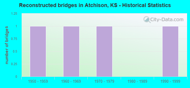
- Reconstructed bridges - Historical Statistics
- 11950-1959
- 11960-1969
- 11970-1979
- 01980-1989
- 11990-1999
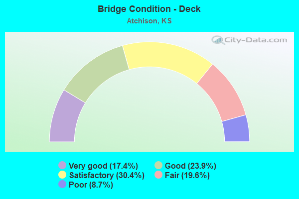
- Bridge Condition - Deck
- 17.4%Very good
- 23.9%Good
- 30.4%Satisfactory
- 19.6%Fair
- 8.7%Poor
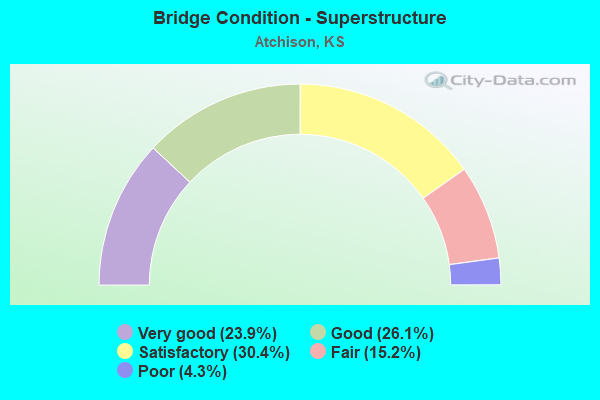
- Bridge Condition - Superstructure
- 23.9%Very good
- 26.1%Good
- 30.4%Satisfactory
- 15.2%Fair
- 4.3%Poor
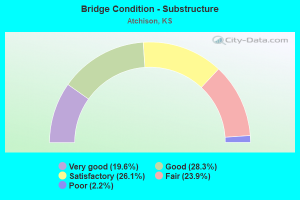
- Bridge Condition - Substructure
- 19.6%Very good
- 28.3%Good
- 26.1%Satisfactory
- 23.9%Fair
- 2.2%Poor
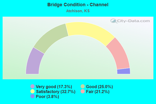
- Bridge Condition - Channel
- 17.3%Very good
- 25.0%Good
- 32.7%Satisfactory
- 21.2%Fair
- 3.8%Poor
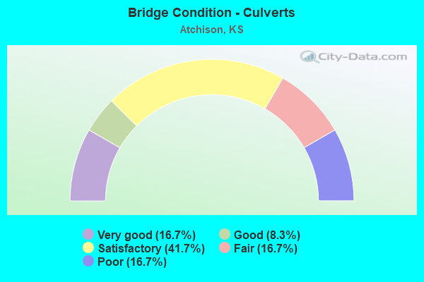
- Bridge Condition - Culverts
- 16.7%Very good
- 8.3%Good
- 41.7%Satisfactory
- 16.7%Fair
- 16.7%Poor
Find on map >> Show street view
Structure Number: 3015, Location: 1.0N 1.0E OF SHANNON (Lat: 39.579508, Lng: -95.227322), Route carried "on" structure: County highway 22, Year Built: 1971, Status: Posted for load, Structure Length: 0.73m (2.40ft), Average Daily Traffic: 267 (year 2007), Truck Traffic: 11%, Average Future Daily Traffic: 300 (year 2040), Design Load: H 15, Features Intersected: DEER CREEK
Minimum Vertical Clearance: 30.47m (99.97ft), Kilometerpoint: 1.000, Lanes on structure: 2, Owner: County Highway Agency, Approaching Roadway Width: 7.8m (25.6ft), Skew: 3 degrees, Material/Design: Concrete, Design/Construction: Culvert, Number Of Spans In Main Unit: 2, Length of Maximum Span: 3.5m (11.5ft), Curb-To-Curb Width: 7.9m (25.9ft), Out-to-Out Width: 10.7m (35.1ft)
Condition: Channel: Satisfactory, Culverts: Satisfactory, Operating Rating: 60.7 metric tons, Method Used To Determine Operating Rating: Load Factor (LF), Inventory Rating: 36.4 metric tons, Method Used To Determine Inventory Rating: Load Factor (LF), Structural Evaluation: Equal to present minimum criteria, Deck Geometry: Somewhat better than minimum adequacy, Waterway Adequacy: Better than present minimum criteria, Approach Roadway Alignment: Equal to present desirable criteria, Designated Inspection Frequency: Every 24 months, Inspection Date: July 2020
Find on map >> Show street view
Structure Number: 3026, Location: 3.0E 1.0N OF SHANNON (Lat: 39.583111, Lng: -95.180925), Route carried "on" structure: County highway 27, Year Built: 1922, Status: Posted for load, Structure Length: 1.65m (5.41ft), Average Daily Traffic: 347 (year 2007), Truck Traffic: 11%, Average Future Daily Traffic: 387 (year 2040), Features Intersected: DEER CREEK
Minimum Vertical Clearance: 30.47m (99.97ft), Kilometerpoint: 1.000, Lanes on structure: 2, Owner: County Highway Agency, Approaching Roadway Width: 6.4m (21.0ft), Material/Design: Concrete, Design/Construction: Slab, Number Of Spans In Main Unit: 1, Length of Maximum Span: 15.2m (49.9ft), Curb-To-Curb Width: 6.1m (20.0ft), Out-to-Out Width: 6.4m (21.0ft)
Condition: Deck: Fair, Superstructure: Fair, Substructure: Fair, Channel: Satisfactory, Operating Rating: 18.0 metric tons, Method Used To Determine Operating Rating: Allowable Stress (AS), Inventory Rating: 15.3 metric tons, Method Used To Determine Inventory Rating: Allowable Stress (AS), Structural Evaluation: Meets minimum limits, Deck Geometry: Meets minimum limits, Waterway Adequacy: Equal to present minimum criteria, Approach Roadway Alignment: Better than present minimum criteria, Bridge Posting: Required (Relationship of Operating Rating to Maximum Legal Load: 10.0 - 19.9% below), Designated Inspection Frequency: Every 24 months, Inspection Date: July 2020, Deck Structure Type: Other, Wearing Surface/Protective System: Wearing Surface: Gravel
Find on map >> Show street view
Structure Number: 3028, Location: 3.0N OF ATCHISON (Lat: 39.608281, Lng: -95.115239), Route carried "on" structure: County highway 28, Year Built: 2003, Status: Open, Structure Length: 4.49m (14.73ft), Average Daily Traffic: 311 (year 2007), Truck Traffic: 10%, Average Future Daily Traffic: 400 (year 2040), Design Load: HS 20, Features Intersected: DEER CREEK
Minimum Vertical Clearance: 30.47m (99.97ft), Kilometerpoint: 1.000, Lanes on structure: 2, Owner: County Highway Agency, Approaching Roadway Width: 7.3m (24.0ft), Skew: 3 degrees, Material/Design: Concrete continuous, Design/Construction: Slab, Number Of Spans In Main Unit: 3, Length of Maximum Span: 17.6m (57.7ft), Curb-To-Curb Width: 8.6m (28.2ft), Out-to-Out Width: 9.2m (30.2ft)
Condition: Deck: Very good, Superstructure: Very good, Substructure: Very good, Channel: Very good, Operating Rating: 80.6 metric tons, Method Used To Determine Operating Rating: Load Factor (LF), Inventory Rating: 48.3 metric tons, Method Used To Determine Inventory Rating: Load Factor (LF), Structural Evaluation: Equal to present desirable criteria, Deck Geometry: Equal to present minimum criteria, Waterway Adequacy: Equal to present desirable criteria, Approach Roadway Alignment: Equal to present desirable criteria, Designated Inspection Frequency: Every 24 months, Inspection Date: July 2020, Deck Structure Type: Concrete Cast-file-Place, Wearing Surface/Protective System: Wearing Surface: Low Slump Concrete
Find on map >> Show street view
Structure Number: 3038, Location: 3.7E OF FARMINGTON (Lat: 39.520442, Lng: -95.240953), Route carried "on" structure: County highway 1290, Year Built: 1958, Status: Posted for load, Structure Length: 3.87m (12.70ft), Average Daily Traffic: 97 (year 2007), Average Future Daily Traffic: 110 (year 2040), Design Load: H 15, Features Intersected: STREAM
Minimum Vertical Clearance: 30.47m (99.97ft), Kilometerpoint: 1.000, Lanes on structure: 2, Owner: County Highway Agency, Approaching Roadway Width: 6.3m (20.7ft), Skew: 1 degrees, Material/Design: Steel continuous, Design/Construction: Stringer/Multi-beam, Number Of Spans In Main Unit: 3, Length of Maximum Span: 14.3m (46.9ft), Curb-To-Curb Width: 7.3m (24.0ft), Out-to-Out Width: 8.2m (26.9ft)
Condition: Deck: Satisfactory, Superstructure: Good, Substructure: Good, Channel: Satisfactory, Operating Rating: 24.7 metric tons, Method Used To Determine Operating Rating: Load Factor (LF), Inventory Rating: 14.8 metric tons, Method Used To Determine Inventory Rating: Load Factor (LF), Structural Evaluation: Meets minimum limits, Deck Geometry: Equal to present minimum criteria, Waterway Adequacy: Better than present minimum criteria, Approach Roadway Alignment: Equal to present desirable criteria, Designated Inspection Frequency: Every 24 months, Inspection Date: July 2020, Deck Structure Type: Other, Wearing Surface/Protective System: Wearing Surface: Monolithic Concrete
Find on map >> Show street view
Structure Number: 3039, Location: 4.2E OF FARMINGTON (Lat: 39.520472, Lng: -95.231694), Route carried "on" structure: County highway 1290, Year Built: 1955, Status: Posted for load, Structure Length: 0.76m (2.49ft), Average Daily Traffic: 97 (year 2007), Truck Traffic: 30%, Average Future Daily Traffic: 110 (year 2040), Design Load: H 15, Features Intersected: STREAM
Minimum Vertical Clearance: 30.47m (99.97ft), Kilometerpoint: 1.000, Lanes on structure: 2, Owner: County Highway Agency, Approaching Roadway Width: 6.4m (21.0ft), Material/Design: Concrete, Design/Construction: Culvert, Number Of Spans In Main Unit: 2, Length of Maximum Span: 3.7m (12.1ft), Curb or Sidewalk Widths: Left: 0.4m (1.3ft), Right: 0.4m (1.3ft), Curb-To-Curb Width: 7.9m (25.9ft), Out-to-Out Width: 8.7m (28.5ft)
Condition: Channel: Fair, Culverts: Satisfactory, Operating Rating: 19.4 metric tons, Method Used To Determine Operating Rating: Load Factor (LF), Inventory Rating: 11.6 metric tons, Method Used To Determine Inventory Rating: Load Factor (LF), Structural Evaluation: Meets minimum limits, Deck Geometry: Equal to present minimum criteria, Waterway Adequacy: Equal to present minimum criteria, Approach Roadway Alignment: Equal to present desirable criteria, Bridge Posting: Required (Relationship of Operating Rating to Maximum Legal Load: 10.0 - 19.9% below), Designated Inspection Frequency: Every 24 months, Inspection Date: July 2020
Find on map >> Show street view
Structure Number: 304, Location: 3.5E 1.5S OF SHANNON (Lat: 39.543331, Lng: -95.173267), Route carried "on" structure: County highway 1290, Year Built: 1936, Year Reconstructed: 1977, Status: Posted for load, Structure Length: 0.93m (3.05ft), Average Daily Traffic: 440 (year 2007), Truck Traffic: 11%, Average Future Daily Traffic: 855 (year 2040), Features Intersected: STREAM
Minimum Vertical Clearance: 30.47m (99.97ft), Kilometerpoint: 1.000, Lanes on structure: 2, Owner: County Highway Agency, Approaching Roadway Width: 6.8m (22.3ft), Material/Design: Concrete, Design/Construction: Culvert, Number Of Spans In Main Unit: 2, Length of Maximum Span: 4.3m (14.1ft), Curb-To-Curb Width: 10.1m (33.1ft), Out-to-Out Width: 10.7m (35.1ft)
Condition: Channel: Poor, Culverts: Poor, Operating Rating: 52.1 metric tons, Method Used To Determine Operating Rating: Load Factor (LF), Inventory Rating: 31.2 metric tons, Method Used To Determine Inventory Rating: Load Factor (LF), Structural Evaluation: Meets minimum limits, Deck Geometry: Equal to present minimum criteria, Waterway Adequacy: Equal to present minimum criteria, Approach Roadway Alignment: Equal to present minimum criteria, Length Of Structure Improvement: 2.74m (8.99ft), Designated Inspection Frequency: Every 24 months, Inspection Date: July 2020, Bridge Improvement Cost: $200,000, Roadway Improvement Cost: $100,000, Total Project Cost: $305,000
Find on map >> Show street view
Structure Number: 3052, Location: 3.0N 2.0W OF ATCHISON (Lat: 39.610703, Lng: -95.153308), Route carried "on" structure: County highway 1869, Year Built: 1920, Status: Posted for load, Structure Length: 0.91m (2.99ft), Average Daily Traffic: 109 (year 2007), Average Future Daily Traffic: 113 (year 2040), Features Intersected: STREAM
Minimum Vertical Clearance: 30.47m (99.97ft), Kilometerpoint: 1.000, Lanes on structure: 1, Owner: County Highway Agency, Approaching Roadway Width: 6.4m (21.0ft), Material/Design: Steel, Design/Construction: Stringer/Multi-beam, Number Of Spans In Main Unit: 1, Length of Maximum Span: 8.5m (27.9ft), Curb-To-Curb Width: 4.6m (15.1ft), Out-to-Out Width: 4.9m (16.1ft)
Condition: Deck: Satisfactory, Superstructure: Satisfactory, Substructure: Satisfactory, Channel: Satisfactory, Operating Rating: 14.5 metric tons, Method Used To Determine Operating Rating: Load Factor (LF), Inventory Rating: 8.7 metric tons, Method Used To Determine Inventory Rating: Load Factor (LF), Structural Evaluation: High priority of corrective action, Deck Geometry: High priority of replacement, Waterway Adequacy: Equal to present minimum criteria, Approach Roadway Alignment: Meets minimum limits, Bridge Posting: Required (Relationship of Operating Rating to Maximum Legal Load: 20.0 - 29.9% below), Length Of Structure Improvement: 2.13m (6.99ft), Designated Inspection Frequency: Every 24 months, Inspection Date: July 2020, Bridge Improvement Cost: $150,000, Roadway Improvement Cost: $100,000, Total Project Cost: $255,000, Deck Structure Type: Other, Wearing Surface/Protective System: Wearing Surface: Gravel
Find on map >> Show street view
Structure Number: 3053, Location: 3.5S OF ATCHISON (Lat: 39.490769, Lng: -95.095436), Route carried "on" structure: County highway 2105, Year Built: 1922, Year Reconstructed: 1955, Status: Posted for load, Structure Length: 1.32m (4.33ft), Average Daily Traffic: 108 (year 2007), Truck Traffic: 11%, Average Future Daily Traffic: 216 (year 2040), Design Load: H 20, Features Intersected: WALNUT CREEK
Minimum Vertical Clearance: 30.47m (99.97ft), Kilometerpoint: 1.000, Lanes on structure: 2, Owner: County Highway Agency, Approaching Roadway Width: 6.8m (22.3ft), Material/Design: Concrete, Design/Construction: Slab, Number Of Spans In Main Unit: 1, Length of Maximum Span: 12.7m (41.7ft), Curb or Sidewalk Widths: Left: 0.6m (2.0ft), Right: 0.6m (2.0ft), Curb-To-Curb Width: 8.5m (27.9ft), Out-to-Out Width: 10.1m (33.1ft)
Condition: Deck: Poor, Superstructure: Poor, Substructure: Fair, Channel: Fair, Operating Rating: 37.5 metric tons, Method Used To Determine Operating Rating: Load Factor (LF), Inventory Rating: 22.4 metric tons, Method Used To Determine Inventory Rating: Load Factor (LF), Structural Evaluation: Meets minimum limits, Deck Geometry: Equal to present minimum criteria, Waterway Adequacy: Equal to present minimum criteria, Approach Roadway Alignment: Equal to present desirable criteria, Bridge Posting: Required (Relationship of Operating Rating to Maximum Legal Load: 0.1 - 9.9% below), Length Of Structure Improvement: 2.74m (8.99ft), Designated Inspection Frequency: Every 24 months, Inspection Date: July 2020, Bridge Improvement Cost: $200,000, Roadway Improvement Cost: $100,000, Total Project Cost: $305,000, Deck Structure Type: Concrete Cast-file-Place, Wearing Surface/Protective System: Wearing Surface: Bituminous
Find on map >> Show street view
Structure Number: 3B27, Location: 2.8E 1.2N OF SHANNON (Lat: 39.585700, Lng: -95.182878), Route carried "on" structure: County highway 27, Year Built: 2021, Status: Open, Structure Length: 1.98m (6.50ft), Average Daily Traffic: 347 (year 2007), Truck Traffic: 11%, Average Future Daily Traffic: 387 (year 2041), Design Load: HL 93, Features Intersected: DEER CREEK
Minimum Vertical Clearance: 30.47m (99.97ft), Kilometerpoint: 0.000, Lanes on structure: 2, Owner: County Highway Agency, Approaching Roadway Width: 6.6m (21.7ft), Material/Design: Steel, Design/Construction: Stringer/Multi-beam, Number Of Spans In Main Unit: 1, Length of Maximum Span: 19.4m (63.6ft), Curb-To-Curb Width: 8.5m (27.9ft), Out-to-Out Width: 8.7m (28.5ft)
Condition: Deck: Very good, Superstructure: Very good, Substructure: Very good, Channel: Satisfactory, Operating Rating: 82.6 metric tons, Method Used To Determine Operating Rating: Load and Resistance Factor Rating (LRFR) rating reported by rating factor(RF) method using HL-93 loadings, Inventory Rating: 60.6 metric tons, Method Used To Determine Inventory Rating: Load and Resistance Factor Rating (LRFR) rating reported by rating factor(RF) method using HL-93 loadings, Structural Evaluation: Equal to present desirable criteria, Deck Geometry: Equal to present minimum criteria, Waterway Adequacy: Equal to present minimum criteria, Approach Roadway Alignment: Better than present minimum criteria, Designated Inspection Frequency: Every 24 months, Inspection Date: September 2021, Deck Structure Type: Concrete Cast-file-Place, Wearing Surface/Protective System: Wearing Surface: Monolithic Concrete
Find on map >> Show street view
Structure Number: 70014, Location: 0.3S 4.1W OF HIAWATHA (Lat: 39.838089, Lng: -95.639175), Route carried "on" structure: County highway 61, Year Built: 1930, Status: Posted for load, Structure Length: 2.16m (7.09ft), Average Daily Traffic: 275 (year 2016), Truck Traffic: 10%, Average Future Daily Traffic: 350 (year 2041), Design Load: HS 20, Features Intersected: WALNUT CREEK
Minimum Vertical Clearance: 30.47m (99.97ft), Kilometerpoint: 1.000, Lanes on structure: 2, Owner: County Highway Agency, Approaching Roadway Width: 6.7m (22.0ft), Material/Design: Steel, Design/Construction: Truss - Thru, Number Of Spans In Main Unit: 1, Length of Maximum Span: 21.3m (69.9ft), Curb-To-Curb Width: 6.1m (20.0ft), Out-to-Out Width: 6.1m (20.0ft)
Condition: Deck: Fair, Superstructure: Fair, Substructure: Fair, Channel: Fair, Operating Rating: 36.9 metric tons, Method Used To Determine Operating Rating: Load Factor (LF), Inventory Rating: 22.2 metric tons, Method Used To Determine Inventory Rating: Load Factor (LF), Structural Evaluation: Somewhat better than minimum adequacy, Deck Geometry: Meets minimum limits, Waterway Adequacy: Equal to present minimum criteria, Approach Roadway Alignment: Equal to present desirable criteria, Length Of Structure Improvement: 2.74m (8.99ft), Designated Inspection Frequency: Every 24 months, Critical Feature Inspection Frequency: Every 24 months, Inspection Date: October 2021, Critical Feature Inspection Date: October 2021, Bridge Improvement Cost: $235,000, Roadway Improvement Cost: $130,000, Total Project Cost: $370,000 ( Estimate for 2018), Deck Structure Type: Concrete Cast-file-Place, Wearing Surface/Protective System: Wearing Surface: Bituminous
Find on map >> Show street view
Structure Number: 70018, Location: 2.6N 0.4E OF FAIRVIEW (Lat: 39.879436, Lng: -95.713964), Route carried "on" structure: County highway 62, Year Built: 1940, Year Reconstructed: 1960, Status: Posted for load, Structure Length: 0.63m (2.07ft), Average Daily Traffic: 265 (year 2016), Truck Traffic: 10%, Average Future Daily Traffic: 278 (year 2042), Design Load: HS 20, Features Intersected: MULBERRY CREEK
Minimum Vertical Clearance: 30.47m (99.97ft), Kilometerpoint: 1.000, Lanes on structure: 2, Owner: County Highway Agency, Approaching Roadway Width: 6.8m (22.3ft), Material/Design: Concrete, Design/Construction: Culvert, Number Of Spans In Main Unit: 2, Length of Maximum Span: 3.0m (9.8ft), Curb-To-Curb Width: 9.1m (29.9ft), Out-to-Out Width: 10.4m (34.1ft)
Condition: Channel: Fair, Culverts: Fair, Operating Rating: 18.1 metric tons, Method Used To Determine Operating Rating: Field evaluation and documented engineering judgment, Inventory Rating: 18.1 metric tons, Method Used To Determine Inventory Rating: Field evaluation and documented engineering judgment, Structural Evaluation: Somewhat better than minimum adequacy, Deck Geometry: Equal to present minimum criteria, Waterway Adequacy: Equal to present minimum criteria, Approach Roadway Alignment: Equal to present desirable criteria, Bridge Posting: Required (Relationship of Operating Rating to Maximum Legal Load: > 39.9% below), Length Of Structure Improvement: 2.90m (9.51ft), Designated Inspection Frequency: Every 24 months, Inspection Date: January 2022, Other Special Inspection Date: September 2021, Bridge Improvement Cost: $80,000, Roadway Improvement Cost: $40,000, Total Project Cost: $170,000
Find on map >> Show street view
Structure Number: 22003, Location: 0.5S OF DONIPHAN (Lat: 39.635278, Lng: -95.081944), Route carried "on" structure: County highway 28, Year Built: 1973, Status: Posted for load, Structure Length: 0.94m (3.08ft), Average Daily Traffic: 175 (year 2005), Truck Traffic: 11%, Average Future Daily Traffic: 200 (year 2041), Features Intersected: STREAM
Minimum Vertical Clearance: 30.47m (99.97ft), Kilometerpoint: 2.510, Lanes on structure: 2, Owner: County Highway Agency, Approaching Roadway Width: 4.2m (13.8ft), Material/Design: Steel, Design/Construction: Stringer/Multi-beam, Number Of Spans In Main Unit: 1, Length of Maximum Span: 8.7m (28.5ft), Curb-To-Curb Width: 7.1m (23.3ft), Out-to-Out Width: 7.3m (24.0ft)
Condition: Deck: Satisfactory, Superstructure: Good, Substructure: Good, Channel: Good, Operating Rating: 37.8 metric tons, Method Used To Determine Operating Rating: Load Factor (LF), Inventory Rating: 22.7 metric tons, Method Used To Determine Inventory Rating: Load Factor (LF), Structural Evaluation: Equal to present minimum criteria, Deck Geometry: Meets minimum limits, Waterway Adequacy: Equal to present minimum criteria, Approach Roadway Alignment: Meets minimum limits, Designated Inspection Frequency: Every 24 months, Inspection Date: Febuary 2021, Deck Structure Type: Corrugated Steel, Wearing Surface/Protective System: Wearing Surface: Bituminous
Find on map >> Show street view
Structure Number: 22022, Location: 1.0N 1.5W OF DONIPHAN (Lat: 39.651667, Lng: -95.110000), Route carried "on" structure: County highway 823, Year Built: 1962, Status: Posted for load, Structure Length: 4.88m (16.01ft), Average Daily Traffic: 111 (year 2005), Truck Traffic: 5%, Average Future Daily Traffic: 120 (year 2041), Design Load: H 15, Features Intersected: ROCK CREEK
Minimum Vertical Clearance: 30.47m (99.97ft), Kilometerpoint: 1.180, Lanes on structure: 2, Owner: County Highway Agency, Approaching Roadway Width: 6.3m (20.7ft), Material/Design: Concrete continuous, Design/Construction: Tee Beam, Number Of Spans In Main Unit: 3, Length of Maximum Span: 17.7m (58.1ft), Curb or Sidewalk Widths: Left: 0.3m (1.0ft), Right: 0.3m (1.0ft), Curb-To-Curb Width: 7.3m (24.0ft), Out-to-Out Width: 8.0m (26.2ft)
Condition: Deck: Satisfactory, Superstructure: Satisfactory, Substructure: Fair, Channel: Fair, Operating Rating: 8.7 metric tons, Method Used To Determine Operating Rating: Load Factor (LF), Inventory Rating: 5.2 metric tons, Method Used To Determine Inventory Rating: Load Factor (LF), Structural Evaluation: High priority of replacement, Deck Geometry: Somewhat better than minimum adequacy, Waterway Adequacy: Better than present minimum criteria, Approach Roadway Alignment: Equal to present minimum criteria, Bridge Posting: Required (Relationship of Operating Rating to Maximum Legal Load: > 39.9% below), Length Of Structure Improvement: 5.18m (16.99ft), Designated Inspection Frequency: Every 24 months, Inspection Date: Febuary 2021, Bridge Improvement Cost: $297,000, Roadway Improvement Cost: $70,000, Total Project Cost: $445,000, Deck Structure Type: Concrete Cast-file-Place
Find on map >> Show street view
Structure Number: 31041003609, Location: 0.9S 1.5E OF LANCASTER (Lat: 39.550586, Lng: -95.272547), Route carried "on" structure: County highway , Year Built: 1910, Status: Posted for load-capacity, Structure Length: 0.67m (2.20ft), Average Daily Traffic: 10 (year 2007), Average Future Daily Traffic: 15 (year 2040), Features Intersected: TRIB. INDEPENDENCE CK., Facility Carried by Structure: LOCAL RD. 17-J.1
Minimum Vertical Clearance: 30.47m (99.97ft), Kilometerpoint: 1.000, Lanes on structure: 1, Owner: County Highway Agency, Approaching Roadway Width: 5.2m (17.1ft), Material/Design: Concrete, Design/Construction: Tee Beam, Number Of Spans In Main Unit: 1, Length of Maximum Span: 6.1m (20.0ft), Curb-To-Curb Width: 4.6m (15.1ft), Out-to-Out Width: 5.0m (16.4ft)
Condition: Deck: Fair, Superstructure: Satisfactory, Substructure: Fair, Channel: Satisfactory, Operating Rating: 32.4 metric tons, Method Used To Determine Operating Rating: Allowable Stress (AS), Inventory Rating: 24.3 metric tons, Method Used To Determine Inventory Rating: Allowable Stress (AS), Structural Evaluation: Somewhat better than minimum adequacy, Deck Geometry: Better than present minimum criteria, Waterway Adequacy: Equal to present minimum criteria, Approach Roadway Alignment: Equal to present desirable criteria, Designated Inspection Frequency: Every 24 months, Inspection Date: July 2020, Deck Structure Type: Other, Wearing Surface/Protective System: Wearing Surface: Other
Find on map >> Show street view
Structure Number: 3104110358, Location: 0.5N 2.2E OF LANCASTER (Lat: 39.580139, Lng: -95.262381), Route carried "on" structure: County highway , Year Built: 1910, Status: Posted for load, Structure Length: 1.01m (3.31ft), Average Daily Traffic: 10 (year 2007), Average Future Daily Traffic: 15 (year 2040), Features Intersected: INDEPENDENCE CREEK, Facility Carried by Structure: LOCAL RD. L-17.5
Minimum Vertical Clearance: 30.47m (99.97ft), Kilometerpoint: 1.000, Lanes on structure: 2, Owner: County Highway Agency, Approaching Roadway Width: 5.2m (17.1ft), Material/Design: Concrete, Design/Construction: Stringer/Multi-beam, Number Of Spans In Main Unit: 1, Length of Maximum Span: 9.4m (30.8ft), Curb-To-Curb Width: 4.9m (16.1ft), Out-to-Out Width: 5.3m (17.4ft)
Condition: Deck: Satisfactory, Superstructure: Fair, Substructure: Fair, Channel: Good, Operating Rating: 13.5 metric tons, Method Used To Determine Operating Rating: Allowable Stress (AS), Inventory Rating: 9.0 metric tons, Method Used To Determine Inventory Rating: Allowable Stress (AS), Structural Evaluation: High priority of replacement, Deck Geometry: High priority of corrective action, Waterway Adequacy: Equal to present minimum criteria, Approach Roadway Alignment: Equal to present desirable criteria, Bridge Posting: Required (Relationship of Operating Rating to Maximum Legal Load: 30.0 - 39.9% below), Length Of Structure Improvement: 2.04m (6.69ft), Designated Inspection Frequency: Every 24 months, Inspection Date: July 2020, Bridge Improvement Cost: $150,000, Roadway Improvement Cost: $100,000, Total Project Cost: $255,000, Deck Structure Type: Other, Wearing Surface/Protective System: Wearing Surface: Other
Find on map >> Show street view
Structure Number: 31041203523, Location: 3.0N 2.3E OF LANCASTER (Lat: 39.616422, Lng: -95.260236), Route carried "on" structure: County highway , Year Built: 1947, Status: Posted for load, Structure Length: 1.55m (5.09ft), Average Daily Traffic: 10 (year 2007), Average Future Daily Traffic: 15 (year 2039), Features Intersected: INDEPENDENCE CREEK, Facility Carried by Structure: LOCAL RD. N.5-17.7
Minimum Vertical Clearance: 30.47m (99.97ft), Kilometerpoint: 1.000, Lanes on structure: 1, Owner: County Highway Agency, Approaching Roadway Width: 5.4m (17.7ft), Material/Design: Steel, Design/Construction: Girder and Floorbeam System, Number Of Spans In Main Unit: 1, Length of Maximum Span: 14.5m (47.6ft), Curb or Sidewalk Widths: Left: 0.2m (0.7ft), Right: 0.2m (0.7ft), Curb-To-Curb Width: 4.6m (15.1ft), Out-to-Out Width: 4.9m (16.1ft)
Condition: Deck: Fair, Superstructure: Satisfactory, Substructure: Fair, Channel: Satisfactory, Operating Rating: 8.8 metric tons, Method Used To Determine Operating Rating: Load Factor (LF), Inventory Rating: 6.5 metric tons, Method Used To Determine Inventory Rating: Load Factor (LF), Structural Evaluation: High priority of corrective action, Deck Geometry: Better than present minimum criteria, Waterway Adequacy: Better than present minimum criteria, Approach Roadway Alignment: Meets minimum limits, Bridge Posting: Required (Relationship of Operating Rating to Maximum Legal Load: > 39.9% below), Designated Inspection Frequency: Every 24 months, Critical Feature Inspection Frequency: Every 24 months, Inspection Date: September 2020, Critical Feature Inspection Date: September 2020, Deck Structure Type: Wood or Timber
Find on map >> Show street view
Structure Number: 31041303525, Location: 3.1N 2.2E OF LANCASTER (Lat: 39.616614, Lng: -95.260286), Route carried "on" structure: County highway , Year Built: 1985, Status: Open, Structure Length: 3.05m (10.01ft), Average Daily Traffic: 15 (year 2007), Average Future Daily Traffic: 22 (year 2040), Features Intersected: INDEPENDENCE CREEK, Facility Carried by Structure: LOCAL RD. N.6-17.5
Minimum Vertical Clearance: 30.47m (99.97ft), Kilometerpoint: 1.000, Lanes on structure: 2, Owner: County Highway Agency, Approaching Roadway Width: 5.4m (17.7ft), Material/Design: Concrete continuous, Design/Construction: Slab, Number Of Spans In Main Unit: 3, Length of Maximum Span: 12.2m (40.0ft), Curb or Sidewalk Widths: Left: 0.3m (1.0ft), Right: 0.3m (1.0ft), Curb-To-Curb Width: 6.1m (20.0ft), Out-to-Out Width: 6.7m (22.0ft)
Condition: Deck: Good, Superstructure: Very good, Substructure: Very good, Channel: Fair, Operating Rating: 52.2 metric tons, Method Used To Determine Operating Rating: Load Factor (LF), Inventory Rating: 31.5 metric tons, Method Used To Determine Inventory Rating: Load Factor (LF), Structural Evaluation: Better than present minimum criteria, Deck Geometry: Somewhat better than minimum adequacy, Waterway Adequacy: Better than present minimum criteria, Approach Roadway Alignment: Somewhat better than minimum adequacy, Designated Inspection Frequency: Every 24 months, Inspection Date: July 2020, Deck Structure Type: Concrete Cast-file-Place
Find on map >> Show street view
Structure Number: 3104130356, Location: 1.5N 2.3E OF LANCASTER (Lat: 39.594606, Lng: -95.258367), Route carried "on" structure: County highway , Year Built: 1920, Status: Posted for load, Structure Length: 0.69m (2.26ft), Average Daily Traffic: 20 (year 2007), Average Future Daily Traffic: 30 (year 2040), Features Intersected: INDEPENDENCE CREEK, Facility Carried by Structure: LOCAL RD. M-17.6
Minimum Vertical Clearance: 30.47m (99.97ft), Kilometerpoint: 1.000, Lanes on structure: 2, Owner: County Highway Agency, Approaching Roadway Width: 4.6m (15.1ft), Material/Design: Concrete, Design/Construction: Slab, Number Of Spans In Main Unit: 1, Length of Maximum Span: 6.1m (20.0ft), Curb or Sidewalk Widths: Left: 0.4m (1.3ft), Right: 0.4m (1.3ft), Curb-To-Curb Width: 5.2m (17.1ft), Out-to-Out Width: 6.1m (20.0ft)
Condition: Deck: Satisfactory, Superstructure: Satisfactory, Substructure: Satisfactory, Channel: Satisfactory, Inventory Rating: 10.4 metric tons, Method Used To Determine Inventory Rating: Load Factor (LF), Structural Evaluation: High priority of replacement, Deck Geometry: High priority of corrective action, Waterway Adequacy: Equal to present minimum criteria, Approach Roadway Alignment: Equal to present desirable criteria, Length Of Structure Improvement: 1.98m (6.50ft), Designated Inspection Frequency: Every 24 months, Inspection Date: July 2020, Bridge Improvement Cost: $140,000, Roadway Improvement Cost: $100,000, Total Project Cost: $245,000, Deck Structure Type: Concrete Cast-file-Place
Find on map >> Show street view
Structure Number: 31043003523, Location: 3.7N 3.0E OF LANCASTER (Lat: 39.618817, Lng: -95.246133), Route carried "on" structure: County highway , Year Built: 1985, Status: Posted for load, Structure Length: 0.82m (2.69ft), Average Daily Traffic: 5 (year 2007), Average Future Daily Traffic: 8 (year 2040), Features Intersected: TRIB. INDEPENDENCE CREEK, Facility Carried by Structure: LOCAL RD. 18.4-N.7
Minimum Vertical Clearance: 30.47m (99.97ft), Kilometerpoint: 1.000, Lanes on structure: 2, Owner: County Highway Agency, Approaching Roadway Width: 4.9m (16.1ft), Material/Design: Steel, Design/Construction: Stringer/Multi-beam, Number Of Spans In Main Unit: 1, Length of Maximum Span: 7.6m (24.9ft), Curb-To-Curb Width: 6.0m (19.7ft), Out-to-Out Width: 6.1m (20.0ft)
Condition: Deck: Satisfactory, Superstructure: Satisfactory, Substructure: Satisfactory, Channel: Satisfactory, Operating Rating: 21.0 metric tons, Method Used To Determine Operating Rating: Load Factor (LF), Inventory Rating: 15.7 metric tons, Method Used To Determine Inventory Rating: Load Factor (LF), Structural Evaluation: Meets minimum limits, Deck Geometry: Meets minimum limits, Waterway Adequacy: Equal to present minimum criteria, Approach Roadway Alignment: Equal to present desirable criteria, Bridge Posting: Required (Relationship of Operating Rating to Maximum Legal Load: > 39.9% below), Designated Inspection Frequency: Every 24 months, Inspection Date: July 2020, Deck Structure Type: Other, Wearing Surface/Protective System: Wearing Surface: Wood or Timber
Find on map >> Show street view
Structure Number: 31043003623, Location: 1.3S 2.6E OF LANCASTER (Lat: 39.545011, Lng: -95.253989), Route carried "on" structure: County highway 307, Year Built: 1955, Status: Open, Structure Length: 0.98m (3.22ft), Average Daily Traffic: 30 (year 2007), Average Future Daily Traffic: 45 (year 2040), Features Intersected: TRIB. TO STRANGER CREEK, Facility Carried by Structure: MINOR COL 18-I.7
Minimum Vertical Clearance: 30.47m (99.97ft), Kilometerpoint: 1.000, Lanes on structure: 2, Owner: County Highway Agency, Approaching Roadway Width: 6.7m (22.0ft), Material/Design: Steel, Design/Construction: Stringer/Multi-beam, Number Of Spans In Main Unit: 1, Length of Maximum Span: 9.3m (30.5ft), Curb-To-Curb Width: 7.3m (24.0ft), Out-to-Out Width: 7.3m (24.0ft)
Condition: Deck: Satisfactory, Superstructure: Good, Substructure: Fair, Channel: Fair, Operating Rating: 39.6 metric tons, Method Used To Determine Operating Rating: Load Factor (LF), Inventory Rating: 23.7 metric tons, Method Used To Determine Inventory Rating: Load Factor (LF), Structural Evaluation: Somewhat better than minimum adequacy, Deck Geometry: Equal to present minimum criteria, Waterway Adequacy: Equal to present minimum criteria, Approach Roadway Alignment: Equal to present desirable criteria, Designated Inspection Frequency: Every 24 months, Inspection Date: July 2020, Deck Structure Type: Concrete Cast-file-Place, Wearing Surface/Protective System: Wearing Surface: Gravel
Find on map >> Show street view
Structure Number: 31043203625, Location: 2.0S 2.7E OF LANCASTER (Lat: 39.542256, Lng: -95.251989), Route carried "on" structure: County highway , Year Built: 1914, Status: Posted for load, Structure Length: 1.07m (3.51ft), Average Daily Traffic: 25 (year 2007), Average Future Daily Traffic: 37 (year 2040), Features Intersected: TRIB. TO STRANGER CREEK, Facility Carried by Structure: LOCAL RD. I.5-18.2
Minimum Vertical Clearance: 30.47m (99.97ft), Kilometerpoint: 1.000, Lanes on structure: 2, Owner: County Highway Agency, Approaching Roadway Width: 6.4m (21.0ft), Material/Design: Concrete, Design/Construction: Stringer/Multi-beam, Number Of Spans In Main Unit: 1, Length of Maximum Span: 9.8m (32.2ft), Curb or Sidewalk Widths: Left: 0.5m (1.6ft), Right: 0.5m (1.6ft), Curb-To-Curb Width: 4.9m (16.1ft), Out-to-Out Width: 5.9m (19.4ft)
Condition: Deck: Satisfactory, Superstructure: Satisfactory, Substructure: Satisfactory, Channel: Satisfactory, Operating Rating: 18.0 metric tons, Method Used To Determine Operating Rating: Allowable Stress (AS), Inventory Rating: 13.5 metric tons, Method Used To Determine Inventory Rating: Allowable Stress (AS), Structural Evaluation: Meets minimum limits, Deck Geometry: High priority of corrective action, Waterway Adequacy: Equal to present minimum criteria, Approach Roadway Alignment: Equal to present desirable criteria, Bridge Posting: Required (Relationship of Operating Rating to Maximum Legal Load: 10.0 - 19.9% below), Length Of Structure Improvement: 2.29m (7.51ft), Designated Inspection Frequency: Every 24 months, Inspection Date: July 2020, Bridge Improvement Cost: $165,000, Roadway Improvement Cost: $100,000, Total Project Cost: $270,000, Deck Structure Type: Concrete Cast-file-Place, Wearing Surface/Protective System: Wearing Surface: Gravel
Find on map >> Show street view
Structure Number: 31045003664, Location: 2.0W OF PARNELL (Lat: 39.515694, Lng: -95.235283), Route carried "on" structure: County highway , Year Built: 1981, Status: Posted for load, Structure Length: 1.25m (4.10ft), Average Daily Traffic: 5 (year 2007), Average Future Daily Traffic: 7 (year 2040), Features Intersected: TRIB. TO STRANGER CREEK, Facility Carried by Structure: LOCAL RD. 19-G.6
Minimum Vertical Clearance: 30.47m (99.97ft), Kilometerpoint: 1.000, Lanes on structure: 2, Owner: County Highway Agency, Approaching Roadway Width: 3.6m (11.8ft), Material/Design: Steel, Design/Construction: Girder and Floorbeam System, Number Of Spans In Main Unit: 1, Length of Maximum Span: 11.9m (39.0ft), Curb-To-Curb Width: 5.1m (16.7ft), Out-to-Out Width: 5.5m (18.0ft)
Condition: Deck: Fair, Superstructure: Satisfactory, Substructure: Satisfactory, Channel: Fair, Operating Rating: 13.7 metric tons, Method Used To Determine Operating Rating: Load Factor (LF), Inventory Rating: 8.2 metric tons, Method Used To Determine Inventory Rating: Load Factor (LF), Structural Evaluation: High priority of replacement, Deck Geometry: High priority of corrective action, Waterway Adequacy: Equal to present minimum criteria, Approach Roadway Alignment: Better than present minimum criteria, Bridge Posting: Required (Relationship of Operating Rating to Maximum Legal Load: > 39.9% below), Length Of Structure Improvement: 2.87m (9.42ft), Designated Inspection Frequency: Every 24 months, Inspection Date: September 2020, Bridge Improvement Cost: $195,000, Roadway Improvement Cost: $100,000, Total Project Cost: $300,000, Deck Structure Type: Other, Wearing Surface/Protective System: Wearing Surface: Wood or Timber
Find on map >> Show street view
Structure Number: 3104520368, Location: 0.5S 1.7W OF PARNELL (Lat: 39.506283, Lng: -95.229653), Route carried "on" structure: County highway , Year Built: 1925, Status: Posted for load, Structure Length: 1.46m (4.79ft), Average Daily Traffic: 20 (year 2007), Average Future Daily Traffic: 25 (year 2040), Features Intersected: TRIB. TO STRANGER CREEK, Facility Carried by Structure: LOCAL RD. G-19.2
Minimum Vertical Clearance: 30.47m (99.97ft), Kilometerpoint: 1.000, Lanes on structure: 2, Owner: County Highway Agency, Approaching Roadway Width: 4.9m (16.1ft), Skew: 4 degrees, Material/Design: Concrete, Design/Construction: Tee Beam, Number Of Spans In Main Unit: 1, Length of Maximum Span: 13.7m (44.9ft), Curb-To-Curb Width: 5.5m (18.0ft), Out-to-Out Width: 6.1m (20.0ft)
Condition: Deck: Satisfactory, Superstructure: Good, Substructure: Satisfactory, Channel: Satisfactory, Operating Rating: 52.1 metric tons, Method Used To Determine Operating Rating: Load Factor (LF), Inventory Rating: 31.3 metric tons, Method Used To Determine Inventory Rating: Load Factor (LF), Structural Evaluation: Equal to present minimum criteria, Deck Geometry: Meets minimum limits, Waterway Adequacy: Equal to present minimum criteria, Approach Roadway Alignment: Equal to present minimum criteria, Designated Inspection Frequency: Every 24 months, Inspection Date: July 2020, Deck Structure Type: Concrete Cast-file-Place, Wearing Surface/Protective System: Wearing Surface: Monolithic Concrete
Find on map >> Show street view
Structure Number: 31047803585, Location: 0.5N 3.2W OF ATCHISON (Lat: 39.572736, Lng: -95.195064), Route carried "on" structure: County highway , Year Built: 2001, Status: Open, Structure Length: 0.74m (2.43ft), Average Daily Traffic: 10 (year 2007), Average Future Daily Traffic: 15 (year 2040), Design Load: HS 20, Features Intersected: TRIB. INDEPENDENCE CK., Facility Carried by Structure: LOCAL RD. K.5-21.1
Minimum Vertical Clearance: 30.47m (99.97ft), Kilometerpoint: 1.000, Lanes on structure: 2, Owner: County Highway Agency, Approaching Roadway Width: 5.4m (17.7ft), Material/Design: Steel, Design/Construction: Stringer/Multi-beam, Number Of Spans In Main Unit: 1, Length of Maximum Span: 7.1m (23.3ft), Curb-To-Curb Width: 7.3m (24.0ft), Out-to-Out Width: 7.3m (24.0ft)
Condition: Deck: Very good, Superstructure: Very good, Substructure: Very good, Channel: Very good, Operating Rating: 90.6 metric tons, Method Used To Determine Operating Rating: Load Factor (LF), Inventory Rating: 61.5 metric tons, Method Used To Determine Inventory Rating: Load Factor (LF), Structural Evaluation: Equal to present desirable criteria, Deck Geometry: Equal to present minimum criteria, Waterway Adequacy: Equal to present desirable criteria, Approach Roadway Alignment: Somewhat better than minimum adequacy, Designated Inspection Frequency: Every 24 months, Inspection Date: July 2020, Deck Structure Type: Corrugated Steel, Wearing Surface/Protective System: Wearing Surface: Bituminous
Find on map >> Show street view
Structure Number: 31049003647, Location: 2.2S 3.5W OF ATCHISON (Lat: 39.524564, Lng: -95.198611), Route carried "on" structure: County highway , Year Built: 1954, Status: Posted for load, Structure Length: 0.94m (3.08ft), Average Daily Traffic: 20 (year 2007), Average Future Daily Traffic: 30 (year 2040), Features Intersected: TRIB. TO STRANGER CREEK, Facility Carried by Structure: LOCAL RD. 21-H.3
Minimum Vertical Clearance: 30.47m (99.97ft), Kilometerpoint: 1.000, Lanes on structure: 1, Owner: County Highway Agency, Approaching Roadway Width: 4.1m (13.5ft), Material/Design: Steel, Design/Construction: Stringer/Multi-beam, Number Of Spans In Main Unit: 1, Length of Maximum Span: 8.8m (28.9ft), Curb-To-Curb Width: 4.8m (15.7ft), Out-to-Out Width: 4.8m (15.7ft)
Condition: Deck: Satisfactory, Superstructure: Satisfactory, Substructure: Satisfactory, Channel: Satisfactory, Operating Rating: 14.9 metric tons, Method Used To Determine Operating Rating: Load Factor (LF), Inventory Rating: 8.9 metric tons, Method Used To Determine Inventory Rating: Load Factor (LF), Structural Evaluation: High priority of corrective action, Deck Geometry: Equal to present desirable criteria, Waterway Adequacy: Equal to present minimum criteria, Approach Roadway Alignment: Equal to present desirable criteria, Bridge Posting: Required (Relationship of Operating Rating to Maximum Legal Load: > 39.9% below), Designated Inspection Frequency: Every 24 months, Inspection Date: July 2020, Deck Structure Type: Other, Wearing Surface/Protective System: Wearing Surface: Wood or Timber
Find on map >> Show street view
Structure Number: 310495036, Location: 3.7W OF JCT. K-7 (Lat: 39.565639, Lng: -95.189161), Route carried "on" structure: County highway , Year Built: 1998, Status: Open, Structure Length: 0.70m (2.30ft), Average Daily Traffic: 2,675 (year 2007), Truck Traffic: 20%, Average Future Daily Traffic: 3,986 (year 2040), Design Load: HS 20, Features Intersected: DEER CREEK, Facility Carried by Structure: LOCAL RD. K-21.6
Minimum Vertical Clearance: 30.47m (99.97ft), Kilometerpoint: 1.000, Lanes on structure: 2, Owner: County Highway Agency, Approaching Roadway Width: 7.3m (24.0ft), Skew: 3 degrees, Material/Design: Concrete, Design/Construction: Culvert, Number Of Spans In Main Unit: 1, Length of Maximum Span: 7.0m (23.0ft)
Condition: Channel: Very good, Culverts: Very good, Inventory Rating: 25.3 metric tons, Method Used To Determine Inventory Rating: Load Factor (LF), Structural Evaluation: Equal to present minimum criteria, Waterway Adequacy: Equal to present desirable criteria, Approach Roadway Alignment: Equal to present desirable criteria, Designated Inspection Frequency: Every 24 months, Inspection Date: July 2020
Find on map >> Show street view
Structure Number: 31049603625, Location: 1.2S 3.1W OF ATCHISON (Lat: 39.542583, Lng: -95.187828), Route carried "on" structure: County highway , Year Built: 1918, Status: Posted for load, Structure Length: 0.79m (2.59ft), Average Daily Traffic: 25 (year 2007), Average Future Daily Traffic: 37 (year 2040), Features Intersected: TRIB. TO STRANGER CREEK, Facility Carried by Structure: LOCAL RD. I.5-21.6
Minimum Vertical Clearance: 30.47m (99.97ft), Kilometerpoint: 1.000, Lanes on structure: 2, Owner: County Highway Agency, Approaching Roadway Width: 5.4m (17.7ft), Material/Design: Concrete, Design/Construction: Slab, Number Of Spans In Main Unit: 1, Length of Maximum Span: 7.3m (24.0ft), Curb-To-Curb Width: 7.0m (23.0ft), Out-to-Out Width: 7.9m (25.9ft)
Condition: Deck: Fair, Superstructure: Fair, Substructure: Fair, Channel: Poor, Operating Rating: 23.4 metric tons, Method Used To Determine Operating Rating: Allowable Stress (AS), Inventory Rating: 16.2 metric tons, Method Used To Determine Inventory Rating: Allowable Stress (AS), Structural Evaluation: Somewhat better than minimum adequacy, Deck Geometry: Somewhat better than minimum adequacy, Waterway Adequacy: Equal to present minimum criteria, Approach Roadway Alignment: Equal to present desirable criteria, Designated Inspection Frequency: Every 24 months, Inspection Date: July 2020, Deck Structure Type: Concrete Cast-file-Place
Find on map >> Show street view
Structure Number: 31049903563, Location: 2.0N 2.3W OF ATCHISON (Lat: 39.589753, Lng: -95.173022), Route carried "on" structure: County highway , Year Built: 1925, Status: Posted for load, Structure Length: 1.58m (5.18ft), Average Daily Traffic: 20 (year 2007), Average Future Daily Traffic: 25 (year 2040), Features Intersected: DEER CREEK, Facility Carried by Structure: LOCAL RD. 22.3-L.7
Minimum Vertical Clearance: 30.47m (99.97ft), Kilometerpoint: 1.000, Lanes on structure: 1, Owner: County Highway Agency, Approaching Roadway Width: 4.9m (16.1ft), Material/Design: Steel, Design/Construction: Truss - Thru, Number Of Spans In Main Unit: 1, Length of Maximum Span: 15.2m (49.9ft), Curb or Sidewalk Widths: Left: 0.2m (0.7ft), Right: 0.2m (0.7ft), Curb-To-Curb Width: 4.6m (15.1ft), Out-to-Out Width: 4.9m (16.1ft)
Condition: Deck: Fair, Superstructure: Fair, Substructure: Fair, Channel: Fair, Operating Rating: 19.0 metric tons, Method Used To Determine Operating Rating: Load Factor (LF), Inventory Rating: 11.4 metric tons, Method Used To Determine Inventory Rating: Load Factor (LF), Structural Evaluation: Meets minimum limits, Deck Geometry: Better than present minimum criteria, Waterway Adequacy: Somewhat better than minimum adequacy, Approach Roadway Alignment: Equal to present minimum criteria, Bridge Posting: Required (Relationship of Operating Rating to Maximum Legal Load: 0.1 - 9.9% below), Designated Inspection Frequency: Every 24 months, Critical Feature Inspection Frequency: Every 24 months, Inspection Date: September 2020, Critical Feature Inspection Date: September 2020, Deck Structure Type: Concrete Cast-file-Place
Find on map >> Show street view
Structure Number: 3105160352, Location: 4.0N 4.4E of Shannon (Lat: 39.623828, Lng: -95.162078), Route carried "on" structure: County highway , Year Built: 2010, Status: Open, Structure Length: 3.12m (10.24ft), Average Daily Traffic: 70 (year 2008), Average Future Daily Traffic: 75 (year 2040), Design Load: HS 20, Features Intersected: TRIB. INDEPENDENCE CREEK, Facility Carried by Structure: LOCAL RD. O-22.9
Minimum Vertical Clearance: 30.47m (99.97ft), Kilometerpoint: 0.998, Lanes on structure: 2, Owner: County Highway Agency, Approaching Roadway Width: 7.9m (25.9ft), Material/Design: Concrete continuous, Design/Construction: Slab, Number Of Spans In Main Unit: 3, Length of Maximum Span: 12.2m (40.0ft), Curb-To-Curb Width: 7.9m (25.9ft), Out-to-Out Width: 8.5m (27.9ft)
Condition: Deck: Very good, Superstructure: Very good, Substructure: Very good, Channel: Very good, Operating Rating: 82.5 metric tons, Method Used To Determine Operating Rating: Load Factor (LF), Inventory Rating: 29.8 metric tons, Method Used To Determine Inventory Rating: Load Factor (LF), Structural Evaluation: Better than present minimum criteria, Deck Geometry: Equal to present minimum criteria, Waterway Adequacy: Better than present minimum criteria, Approach Roadway Alignment: Equal to present desirable criteria, Designated Inspection Frequency: Every 24 months, Inspection Date: July 2020, Deck Structure Type: Concrete Cast-file-Place, Wearing Surface/Protective System: Wearing Surface: Monolithic Concrete
Find on map >> Show street view
Structure Number: 31053003621, Location: 0.8S 1.5W OF ATCHISON (Lat: 39.549267, Lng: -95.161256), Route carried "on" structure: County highway , Year Built: 1940, Status: Open, Structure Length: 3.89m (12.76ft), Average Daily Traffic: 40 (year 2007), Average Future Daily Traffic: 60 (year 2040), Features Intersected: TRIB. TO WALNUT CREEK, Facility Carried by Structure: LOCAL RD. 23-I.9
Minimum Vertical Clearance: 30.47m (99.97ft), Kilometerpoint: 1.000, Lanes on structure: 2, Owner: County Highway Agency, Approaching Roadway Width: 7.3m (24.0ft), Skew: 3 degrees, Material/Design: Steel continuous, Design/Construction: Stringer/Multi-beam, Number Of Spans In Main Unit: 3, Length of Maximum Span: 14.5m (47.6ft), Curb-To-Curb Width: 7.3m (24.0ft), Out-to-Out Width: 8.0m (26.2ft)
Condition: Deck: Poor, Superstructure: Good, Substructure: Good, Channel: Good, Operating Rating: 44.2 metric tons, Method Used To Determine Operating Rating: Load Factor (LF), Inventory Rating: 26.4 metric tons, Method Used To Determine Inventory Rating: Load Factor (LF), Structural Evaluation: Equal to present minimum criteria, Deck Geometry: Equal to present minimum criteria, Waterway Adequacy: Better than present minimum criteria, Approach Roadway Alignment: Somewhat better than minimum adequacy, Designated Inspection Frequency: Every 24 months, Inspection Date: July 2020, Deck Structure Type: Concrete Cast-file-Place, Wearing Surface/Protective System: Wearing Surface: Bituminous
Find on map >> Show street view
Structure Number: 31053003667, Location: 3.4S 1.5W OF ATCHISON (Lat: 39.509639, Lng: -95.160811), Route carried "on" structure: County highway , Year Built: 1916, Status: Posted for load, Structure Length: 0.94m (3.08ft), Average Daily Traffic: 30 (year 2007), Average Future Daily Traffic: 45 (year 2040), Features Intersected: WALNUT CREEK, Facility Carried by Structure: LOCAL RD. 23-G.3
Minimum Vertical Clearance: 30.47m (99.97ft), Kilometerpoint: 1.000, Lanes on structure: 1, Owner: County Highway Agency, Approaching Roadway Width: 4.7m (15.4ft), Material/Design: Concrete, Design/Construction: Stringer/Multi-beam, Number Of Spans In Main Unit: 1, Length of Maximum Span: 8.5m (27.9ft), Curb or Sidewalk Widths: Left: 0.5m (1.6ft), Right: 0.5m (1.6ft), Curb-To-Curb Width: 5.8m (19.0ft), Out-to-Out Width: 5.8m (19.0ft)
Condition: Deck: Satisfactory, Superstructure: Satisfactory, Substructure: Satisfactory, Channel: Fair, Operating Rating: 28.8 metric tons, Method Used To Determine Operating Rating: Allowable Stress (AS), Inventory Rating: 21.6 metric tons, Method Used To Determine Inventory Rating: Allowable Stress (AS), Structural Evaluation: Equal to present minimum criteria, Deck Geometry: Meets minimum limits, Waterway Adequacy: Equal to present minimum criteria, Approach Roadway Alignment: Equal to present desirable criteria, Designated Inspection Frequency: Every 24 months, Inspection Date: July 2020, Deck Structure Type: Other, Wearing Surface/Protective System: Wearing Surface: Gravel
Find on map >> Show street view
Structure Number: 31053903681, Location: 2.5N OF ST. PATS (Lat: 39.505589, Lng: -95.144036), Route carried "on" structure: County highway , Year Built: 1935, Status: Posted for load, Structure Length: 2.19m (7.19ft), Average Daily Traffic: 10 (year 2007), Average Future Daily Traffic: 15 (year 2040), Features Intersected: WALNUT CREEK, Facility Carried by Structure: LOCAL RD. 23.9-F.9
Minimum Vertical Clearance: 6.09m (19.98ft), Kilometerpoint: 1.000, Lanes on structure: 1, Owner: County Highway Agency, Approaching Roadway Width: 4.1m (13.5ft), Material/Design: Steel, Design/Construction: Truss - Thru, Number Of Spans In Main Unit: 1, Number Of Approach Spans: 1, Length of Maximum Span: 15.2m (49.9ft), Curb or Sidewalk Widths: Left: 0.2m (0.7ft), Right: 0.2m (0.7ft), Curb-To-Curb Width: 4.6m (15.1ft), Out-to-Out Width: 4.9m (16.1ft)
Condition: Deck: Fair, Superstructure: Fair, Substructure: Fair, Channel: Satisfactory, Operating Rating: 8.8 metric tons, Method Used To Determine Operating Rating: Load Factor (LF), Inventory Rating: 6.9 metric tons, Method Used To Determine Inventory Rating: Load Factor (LF), Structural Evaluation: High priority of replacement, Deck Geometry: Better than present minimum criteria, Waterway Adequacy: Somewhat better than minimum adequacy, Approach Roadway Alignment: Meets minimum limits, Bridge Posting: Required (Relationship of Operating Rating to Maximum Legal Load: > 39.9% below), Length Of Structure Improvement: 3.96m (12.99ft), Designated Inspection Frequency: Every 24 months, Critical Feature Inspection Frequency: Every 24 months, Inspection Date: September 2020, Critical Feature Inspection Date: September 2020, Bridge Improvement Cost: $285,000, Roadway Improvement Cost: $100,000, Total Project Cost: $390,000, Deck Structure Type: Concrete Cast-file-Place
Find on map >> Show street view
Structure Number: 31053903685, Location: 4.2S 0.7W OF ATCHISON (Lat: 39.500606, Lng: -95.145478), Route carried "on" structure: County highway , Year Built: 1999, Status: Open, Structure Length: 0.78m (2.56ft), Average Daily Traffic: 15 (year 2007), Average Future Daily Traffic: 22 (year 2040), Design Load: H 20, Features Intersected: TRIB. TO WALNUT CREEK, Facility Carried by Structure: LOCAL RD. 23.9-F.5
Minimum Vertical Clearance: 30.47m (99.97ft), Kilometerpoint: 1.000, Lanes on structure: 2, Owner: County Highway Agency, Approaching Roadway Width: 5.4m (17.7ft), Material/Design: Steel, Design/Construction: Stringer/Multi-beam, Number Of Spans In Main Unit: 1, Length of Maximum Span: 7.6m (24.9ft), Curb-To-Curb Width: 7.3m (24.0ft), Out-to-Out Width: 7.3m (24.0ft)
Condition: Deck: Good, Superstructure: Very good, Substructure: Very good, Channel: Satisfactory, Operating Rating: 72.4 metric tons, Method Used To Determine Operating Rating: Load Factor (LF), Inventory Rating: 43.4 metric tons, Method Used To Determine Inventory Rating: Load Factor (LF), Structural Evaluation: Equal to present desirable criteria, Deck Geometry: Equal to present minimum criteria, Waterway Adequacy: Equal to present minimum criteria, Approach Roadway Alignment: Meets minimum limits, Designated Inspection Frequency: Every 24 months, Inspection Date: September 2020, Deck Structure Type: Corrugated Steel, Wearing Surface/Protective System: Wearing Surface: Bituminous
Find on map >> Show street view
Structure Number: 31057003487, Location: 3.0E OF STATE LAKE (Lat: 39.641872, Lng: -95.114769), Route carried "on" structure: County highway , Year Built: 1985, Status: Open, Structure Length: 4.66m (15.29ft), Average Daily Traffic: 25 (year 2007), Average Future Daily Traffic: 37 (year 2040), Design Load: H 20, Features Intersected: N. BR. INDEPENDENCE CK., Facility Carried by Structure: LOCAL RD. 25.4-P.3
Minimum Vertical Clearance: 30.47m (99.97ft), Kilometerpoint: 1.000, Lanes on structure: 2, Owner: County Highway Agency, Approaching Roadway Width: 6.0m (19.7ft), Material/Design: Concrete continuous, Design/Construction: Slab, Number Of Spans In Main Unit: 3, Length of Maximum Span: 18.3m (60.0ft), Curb-To-Curb Width: 6.1m (20.0ft), Out-to-Out Width: 6.7m (22.0ft)
Condition: Deck: Good, Superstructure: Very good, Substructure: Good, Channel: Good, Operating Rating: 52.3 metric tons, Method Used To Determine Operating Rating: Load Factor (LF), Inventory Rating: 31.2 metric tons, Method Used To Determine Inventory Rating: Load Factor (LF), Structural Evaluation: Better than present minimum criteria, Deck Geometry: Somewhat better than minimum adequacy, Waterway Adequacy: Equal to present desirable criteria, Approach Roadway Alignment: Somewhat better than minimum adequacy, Designated Inspection Frequency: Every 24 months, Inspection Date: July 2020, Deck Structure Type: Concrete Cast-file-Place
Find on map >> Show street view
Structure Number: 31057303649, Location: 2.6S 0.4E OF ATCHISON (Lat: 39.522628, Lng: -95.118606), Route carried "on" structure: County highway , Year Built: 1920, Status: Posted for load, Structure Length: 0.98m (3.22ft), Average Daily Traffic: 30 (year 2007), Average Future Daily Traffic: 45 (year 2041), Features Intersected: TRIB. TO MISSOURI RIVER, Facility Carried by Structure: LOCAL RD. 25.3-H.1
Minimum Vertical Clearance: 30.47m (99.97ft), Kilometerpoint: 1.000, Lanes on structure: 2, Owner: County Highway Agency, Approaching Roadway Width: 4.2m (13.8ft), Material/Design: Concrete, Design/Construction: Arch - Deck, Number Of Spans In Main Unit: 1, Length of Maximum Span: 9.8m (32.2ft), Curb-To-Curb Width: 5.0m (16.4ft), Out-to-Out Width: 5.6m (18.4ft)
Condition: Deck: Poor, Superstructure: Poor, Substructure: Poor, Channel: Satisfactory, Operating Rating: 6.3 metric tons, Method Used To Determine Operating Rating: Allowable Stress (AS), Inventory Rating: 4.5 metric tons, Method Used To Determine Inventory Rating: Allowable Stress (AS), Structural Evaluation: High priority of replacement, Deck Geometry: High priority of corrective action, Waterway Adequacy: Equal to present minimum criteria, Approach Roadway Alignment: Somewhat better than minimum adequacy, Bridge Posting: Required (Relationship of Operating Rating to Maximum Legal Load: > 39.9% below), Length Of Structure Improvement: 1.83m (6.00ft), Designated Inspection Frequency: Every 12 months, Inspection Date: May 2021, Bridge Improvement Cost: $132,000, Roadway Improvement Cost: $100,000, Total Project Cost: $235,000, Deck Structure Type: Other, Wearing Surface/Protective System: Wearing Surface: Gravel
Find on map >> Show street view
Structure Number: 31057403644, Location: 2.5S 0.5E OF ATCHISON (Lat: 39.529250, Lng: -95.116531), Route carried "on" structure: County highway 1508, Year Built: 2017, Status: Open, Structure Length: 1.60m (5.25ft), Average Daily Traffic: 20 (year 2017), Average Future Daily Traffic: 20 (year 2040), Design Load: HL 93, Features Intersected: WHISKEY CREEK, Facility Carried by Structure: LOCAL RD. H.5-25.4
Minimum Vertical Clearance: 30.47m (99.97ft), Kilometerpoint: 0.000, Lanes on structure: 2, Owner: County Highway Agency, Approaching Roadway Width: 7.9m (25.9ft), Material/Design: Concrete, Design/Construction: Culvert, Number Of Spans In Main Unit: 2, Length of Maximum Span: 5.5m (18.0ft), Curb-To-Curb Width: 7.9m (25.9ft), Out-to-Out Width: 11.8m (38.7ft)
Condition: Channel: Very good, Culverts: Very good, Operating Rating: 58.1 metric tons, Method Used To Determine Operating Rating: Load Factor (LF), Inventory Rating: 37.2 metric tons, Method Used To Determine Inventory Rating: Load Factor (LF), Structural Evaluation: Equal to present desirable criteria, Deck Geometry: Equal to present minimum criteria, Waterway Adequacy: Equal to present desirable criteria, Approach Roadway Alignment: Equal to present desirable criteria, Designated Inspection Frequency: Every 24 months, Inspection Date: June 2020, Deck Structure Type: Concrete Cast-file-Place, Wearing Surface/Protective System: Wearing Surface: Gravel
Find on map >> Show street view
Structure Number: 3105910356, Location: 0.8N.E. OF ATCHISON (Lat: 39.594669, Lng: -95.095647), Route carried "on" structure: County highway , Year Built: 1985, Status: Open, Structure Length: 6.00m (19.69ft), Average Daily Traffic: 25 (year 2007), Average Future Daily Traffic: 37 (year 2040), Features Intersected: N. BR. INDEPENDENCE CK., Facility Carried by Structure: LOCAL RD. M-26.4
Minimum Vertical Clearance: 30.47m (99.97ft), Kilometerpoint: 1.000, Lanes on structure: 2, Owner: County Highway Agency, Approaching Roadway Width: 8.1m (26.6ft), Skew: 3 degrees, Material/Design: Steel continuous, Design/Construction: Stringer/Multi-beam, Number Of Spans In Main Unit: 3, Length of Maximum Span: 22.9m (75.1ft), Curb-To-Curb Width: 7.3m (24.0ft), Out-to-Out Width: 7.9m (25.9ft)
Condition: Deck: Good, Superstructure: Good, Substructure: Satisfactory, Channel: Satisfactory, Operating Rating: 35.1 metric tons, Method Used To Determine Operating Rating: Allowable Stress (AS), Inventory Rating: 21.6 metric tons, Method Used To Determine Inventory Rating: Allowable Stress (AS), Structural Evaluation: Equal to present minimum criteria, Deck Geometry: Equal to present minimum criteria, Waterway Adequacy: Equal to present minimum criteria, Approach Roadway Alignment: Equal to present minimum criteria, Designated Inspection Frequency: Every 24 months, Underwater Inspection Frequency: Every 60 months, Inspection Date: July 2020, Underwater Inspection Date: May 2020, Deck Structure Type: Other, Wearing Surface/Protective System: Wearing Surface: Monolithic Concrete
Find on map >> Show street view
Structure Number: 31061503686, Location: 4.5S 3.0E OF ATCHISON (Lat: 39.496961, Lng: -95.076972), Route carried "on" structure: Other road 1516, Year Built: 2015, Status: Open, Structure Length: 3.73m (12.24ft), Average Daily Traffic: 60 (year 2011), Average Future Daily Traffic: 60 (year 2040), Design Load: HL 93, Features Intersected: TRIB. TO MISSOURI RIVER, Facility Carried by Structure: LOCAL RD 27.5-F.3
Minimum Vertical Clearance: 30.47m (99.97ft), Kilometerpoint: 0.000, Lanes on structure: 2, Owner: County Highway Agency, Approaching Roadway Width: 7.9m (25.9ft), Material/Design: Concrete continuous, Design/Construction: Slab, Number Of Spans In Main Unit: 3, Length of Maximum Span: 14.6m (47.9ft), Curb-To-Curb Width: 7.9m (25.9ft), Out-to-Out Width: 8.5m (27.9ft)
Condition: Deck: Very good, Superstructure: Very good, Substructure: Very good, Channel: Very good, Operating Rating: 33.4 metric tons, Method Used To Determine Operating Rating: Load and Resistance Factor Rating (LRFR) rating reported by rating factor(RF) method using HL-93 loadings, Inventory Rating: 25.9 metric tons, Method Used To Determine Inventory Rating: Load and Resistance Factor Rating (LRFR) rating reported by rating factor(RF) method using HL-93 loadings, Structural Evaluation: Equal to present minimum criteria, Deck Geometry: Equal to present minimum criteria, Waterway Adequacy: Equal to present desirable criteria, Approach Roadway Alignment: Better than present minimum criteria, Designated Inspection Frequency: Every 24 months, Inspection Date: June 2020, Deck Structure Type: Concrete Cast-file-Place, Wearing Surface/Protective System: Wearing Surface: Monolithic Concrete
Find on map >> Show street view
Structure Number: 221059703488, Location: 10.0S 0.3E OF TROY (Lat: 39.641783, Lng: -95.083467), Route carried "on" structure: County highway , Year Built: 1999, Status: Open, Structure Length: 0.91m (2.99ft), Average Daily Traffic: 20 (year 2005), Average Future Daily Traffic: 20 (year 2041), Design Load: HS 20, Features Intersected: TRIB. IND. CREEK, Facility Carried by Structure: MINOR T-251-1
Minimum Vertical Clearance: 30.47m (99.97ft), Kilometerpoint: 0.000, Lanes on structure: 2, Owner: County Highway Agency, Approaching Roadway Width: 6.0m (19.7ft), Material/Design: Steel, Design/Construction: Stringer/Multi-beam, Number Of Spans In Main Unit: 1, Length of Maximum Span: 8.8m (28.9ft), Curb-To-Curb Width: 6.1m (20.0ft), Out-to-Out Width: 6.2m (20.3ft)
Condition: Deck: Very good, Superstructure: Good, Substructure: Good, Channel: Good, Operating Rating: 63.2 metric tons, Method Used To Determine Operating Rating: Load Factor (LF), Inventory Rating: 37.8 metric tons, Method Used To Determine Inventory Rating: Load Factor (LF), Structural Evaluation: Better than present minimum criteria, Deck Geometry: Somewhat better than minimum adequacy, Waterway Adequacy: Equal to present minimum criteria, Approach Roadway Alignment: Better than present minimum criteria, Designated Inspection Frequency: Every 24 months, Inspection Date: Febuary 2021, Deck Structure Type: Concrete Cast-file-Place
Find on map >> Show street view
Structure Number: 401350030209002, Location: 14TH ST. IN ATCHISON (Lat: 39.558883, Lng: -95.135497), Route carried "on" structure: City street 209, Year Built: 1981, Status: Open, Structure Length: 5.79m (19.00ft), Average Daily Traffic: 5,550 (year 2013), Average Future Daily Traffic: 6,660 (year 2040), Design Load: HS 20, Features Intersected: AT & SF & MOPAC R.R.
Minimum Vertical Clearance: 30.47m (99.97ft), Kilometerpoint: 0.998, Lanes on structure: 2, Owner: City or Municipal Highway Agency, Approaching Roadway Width: 9.8m (32.2ft), Skew: 1 degrees, Material/Design: Steel continuous, Design/Construction: Stringer/Multi-beam, Number Of Spans In Main Unit: 3, Length of Maximum Span: 23.8m (78.1ft), Curb or Sidewalk Widths: Left: 1.2m (3.9ft), Right: 0.0m, Curb-To-Curb Width: 9.1m (29.9ft), Out-to-Out Width: 11.3m (37.1ft)
Condition: Deck: Good, Superstructure: Satisfactory, Substructure: Good, Operating Rating: 49.3 metric tons, Method Used To Determine Operating Rating: Load Factor (LF), Inventory Rating: 29.5 metric tons, Method Used To Determine Inventory Rating: Load Factor (LF), Structural Evaluation: Equal to present minimum criteria, Deck Geometry: High priority of corrective action, Underclear: Meets minimum limits, Approach Roadway Alignment: Equal to present desirable criteria, Length Of Structure Improvement: 2.59m (8.50ft), Designated Inspection Frequency: Every 24 months, Inspection Date: April 2020, Bridge Improvement Cost: $230,000, Roadway Improvement Cost: $110,000, Total Project Cost: $340,000 ( Estimate for 2016), Deck Structure Type: Concrete Cast-file-Place, Wearing Surface/Protective System: Deck Protection: Epoxy Coated Reinforcing
Find on map >> Show street view
Structure Number: 401350030217001, Location: SIXTH STREET IN ATCHISON (Lat: 39.560500, Lng: -95.120561), Route carried "on" structure: City street 217, Year Built: 1984, Status: Open, Structure Length: 14.14m (46.39ft), Average Daily Traffic: 5,260 (year 2013), Average Future Daily Traffic: 6,312 (year 2040), Design Load: HS 20, Features Intersected: AT & SF RAILROAD
Minimum Vertical Clearance: 30.47m (99.97ft), Kilometerpoint: 0.998, Lanes on structure: 2, Owner: City or Municipal Highway Agency, Approaching Roadway Width: 7.3m (24.0ft), Material/Design: Steel continuous, Design/Construction: Stringer/Multi-beam, Number Of Spans In Main Unit: 2, Number Of Approach Spans: 4, Length of Maximum Span: 31.9m (104.7ft), Curb or Sidewalk Widths: Left: 0.0m, Right: 1.2m (3.9ft), Curb-To-Curb Width: 9.8m (32.2ft), Out-to-Out Width: 12.4m (40.7ft)
Condition: Deck: Good, Superstructure: Good, Substructure: Good, Operating Rating: 61.0 metric tons, Method Used To Determine Operating Rating: Load Factor (LF), Inventory Rating: 27.7 metric tons, Method Used To Determine Inventory Rating: Load Factor (LF), Structural Evaluation: Equal to present minimum criteria, Deck Geometry: Meets minimum limits, Underclear: Somewhat better than minimum adequacy, Approach Roadway Alignment: Equal to present desirable criteria, Designated Inspection Frequency: Every 24 months, Inspection Date: April 2020, Deck Structure Type: Other, Wearing Surface/Protective System: Wearing Surface: Monolithic Concrete, Deck Protection: Epoxy Coated Reinforcing