Bridge Statistics for Ann Arbor, Michigan (MI)
Condition, Traffic, Stress, Structural Evaluation, Project Costs
- National Bridge Inventory (NBI) Statistics
- 228Number of bridges
- 2,772ft / 845mTotal length
- $9,829,000Total costs
- 4,476,390Total average daily traffic
- 444,157Total average daily truck traffic
- National Bridge Inventory (NBI) Registered Bridges for Ann Arbor
- No street view available for this location
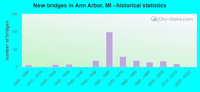
- New bridges - historical statistics
- 61900-1909
- 71920-1929
- 81930-1939
- 11940-1949
- 181950-1959
- 991960-1969
- 301970-1979
- 181980-1989
- 141990-1999
- 172000-2009
- 92010-2019
- 12020-2022

- Reconstructed bridges - Historical Statistics
- 11940-1949
- 01950-1959
- 31960-1969
- 41970-1979
- 21980-1989
- 61990-1999
- 112000-2009
- 12010-2019


- Bridge Condition - Deck
- 1.4%Excellent
- 4.8%Very good
- 26.5%Good
- 38.8%Satisfactory
- 21.8%Fair
- 6.1%Poor
- 0.7%Serious

- Bridge Condition - Superstructure
- 11.5%Very good
- 13.5%Good
- 25.0%Satisfactory
- 39.2%Fair
- 9.5%Poor
- 1.4%Serious

- Bridge Condition - Substructure
- 0.7%Excellent
- 7.4%Very good
- 23.6%Good
- 39.2%Satisfactory
- 19.6%Fair
- 9.5%Poor

- Bridge Condition - Channel
- 1.2%Excellent
- 17.1%Very good
- 32.9%Good
- 34.1%Satisfactory
- 12.2%Fair
- 1.2%Poor
- 1.2%Serious

- Bridge Condition - Culverts
- 5.6%Excellent
- 5.6%Very good
- 33.3%Good
- 33.3%Satisfactory
- 11.1%Fair
- 5.6%Poor
- 5.6%Serious
Find on map >> Show street view
Structure Number: 16, Location: 1.25 S OF MIKADO (Lat: 44.573642, Lng: -83.422289), Route carried "on" structure: County highway 167, Year Built: 1956, Status: Open, Structure Length: 1.22m (4.00ft), Average Daily Traffic: 2,770 (year 2003), Truck Traffic: 8%, Average Future Daily Traffic: 3,740 (year 2023), Design Load: H 20, Features Intersected: VAN ETTEN CREEK, Facility Carried by Structure: COUNTY HWY F41
Minimum Vertical Clearance: 30.48m (100.00ft), Kilometerpoint: 6.887, Lanes on structure: 2, Owner: County Highway Agency, Approaching Roadway Width: 11.0m (36.1ft), Skew: 3 degrees, Material/Design: Concrete continuous, Design/Construction: Culvert, Number Of Spans In Main Unit: 2, Length of Maximum Span: 5.1m (16.7ft), Curb or Sidewalk Widths: Left: 0.2m (0.7ft), Right: 0.2m (0.7ft), Curb-To-Curb Width: 11.0m (36.1ft), Out-to-Out Width: 13.2m (43.3ft)
Condition: Channel: Satisfactory, Culverts: Satisfactory, Operating Rating: 39.6 metric tons, Method Used To Determine Operating Rating: Allowable Stress (AS), Inventory Rating: 24.3 metric tons, Method Used To Determine Inventory Rating: Allowable Stress (AS), Structural Evaluation: Equal to present minimum criteria, Deck Geometry: Somewhat better than minimum adequacy, Waterway Adequacy: Somewhat better than minimum adequacy, Approach Roadway Alignment: Equal to present desirable criteria, Designated Inspection Frequency: Every 24 months, Inspection Date: May 2021, Deck Structure Type: Concrete Cast-file-Place, Wearing Surface/Protective System: Wearing Surface: Bituminous
Find on map >> Show street view
Structure Number: 63, Location: 6.0 MI E OF GRAND MARAIS (Lat: 46.662386, Lng: -85.869425), Route carried "on" structure: County highway , Year Built: 1935, Status: Open, Structure Length: 0.79m (2.59ft), Average Daily Traffic: 200 (year 1997), Truck Traffic: 5%, Average Future Daily Traffic: 400 (year 2015), Features Intersected: SUCKER RIVER, Facility Carried by Structure: COUNTY LINE ROAD
Minimum Vertical Clearance: 30.48m (100.00ft), Kilometerpoint: 9.386, Lanes on structure: 2, Owner: County Highway Agency, Approaching Roadway Width: 9.1m (29.9ft), Skew: 2 degrees, Material/Design: Concrete, Design/Construction: Culvert, Number Of Spans In Main Unit: 2, Length of Maximum Span: 7.3m (24.0ft)
Condition: Channel: Fair, Culverts: Fair, Operating Rating: 48.9 metric tons, Method Used To Determine Operating Rating: Load Factor (LF) rating reported by rating factor (RF) method using MS18 loading, Inventory Rating: 29.2 metric tons, Method Used To Determine Inventory Rating: Load Factor (LF) rating reported by rating factor (RF) method using MS18 loading, Structural Evaluation: Somewhat better than minimum adequacy, Waterway Adequacy: Equal to present desirable criteria, Approach Roadway Alignment: Equal to present desirable criteria, Designated Inspection Frequency: Every 24 months, Inspection Date: September 2021, Wearing Surface/Protective System: Wearing Surface: Bituminous
Find on map >> Show street view
Structure Number: 64, Location: 2 MI E OF W BR LAKE RD (Lat: 46.161697, Lng: -86.694719), Route carried "on" structure: County highway , Year Built: 2001, Status: Open, Structure Length: 1.06m (3.48ft), Average Daily Traffic: 191 (year 1998), Average Future Daily Traffic: 240 (year 2019), Design Load: HS 25 or greater, Features Intersected: STURGEON RIVER, Facility Carried by Structure: ROUND LAKE RD FH78
Minimum Vertical Clearance: 30.48m (100.00ft), Kilometerpoint: 2.437, Lanes on structure: 2, Owner: County Highway Agency, Approaching Roadway Width: 7.9m (25.9ft), Material/Design: Wood or Timber, Design/Construction: Stringer/Multi-beam, Number Of Spans In Main Unit: 2, Length of Maximum Span: 5.3m (17.4ft), Curb-To-Curb Width: 7.3m (24.0ft), Out-to-Out Width: 7.9m (25.9ft)
Condition: Deck: Very good, Superstructure: Very good, Substructure: Very good, Channel: Very good, Operating Rating: 97.2 metric tons, Method Used To Determine Operating Rating: Allowable Stress (AS) rating reported by rating factor (RF) method using MS18 loading, Inventory Rating: 86.8 metric tons, Method Used To Determine Inventory Rating: Allowable Stress (AS) rating reported by rating factor (RF) method using MS18 loading, Structural Evaluation: Equal to present desirable criteria, Deck Geometry: Somewhat better than minimum adequacy, Waterway Adequacy: Equal to present desirable criteria, Approach Roadway Alignment: Equal to present desirable criteria, Designated Inspection Frequency: Every 24 months, Inspection Date: September 2021, Deck Structure Type: Wood or Timber, Wearing Surface/Protective System: Wearing Surface: Bituminous
Find on map >> Show street view
Structure Number: 132, Location: 1.2 MI S OF OTTAWA COL (Lat: 42.754764, Lng: -86.056708), Route carried "on" structure: County highway 386, Year Built: 1972, Status: Open, Structure Length: 12.10m (39.70ft), Average Daily Traffic: 1,893 (year 1997), Truck Traffic: 2%, Average Future Daily Traffic: 560 (year 1977), Design Load: H 20, Features Intersected: I-196, Facility Carried by Structure: 146 TH AVE
Minimum Vertical Clearance: 30.48m (100.00ft), Kilometerpoint: 3.214, Lanes on structure: 2, Lanes under structure: 4, Owner: State Highway Agency, Approaching Roadway Width: 12.9m (42.3ft), Skew: 3 degrees, Material/Design: Steel, Design/Construction: Stringer/Multi-beam, Number Of Spans In Main Unit: 5, Length of Maximum Span: 34.4m (112.9ft), Curb-To-Curb Width: 12.3m (40.4ft), Out-to-Out Width: 13.5m (44.3ft)
Condition: Deck: Good, Superstructure: Fair, Substructure: Good, Operating Rating: 62.2 metric tons, Method Used To Determine Operating Rating: Load Factor (LF) rating reported by rating factor (RF) method using MS18 loading, Inventory Rating: 37.3 metric tons, Method Used To Determine Inventory Rating: Load Factor (LF) rating reported by rating factor (RF) method using MS18 loading, Structural Evaluation: Somewhat better than minimum adequacy, Deck Geometry: Better than present minimum criteria, Underclear: Somewhat better than minimum adequacy, Approach Roadway Alignment: Equal to present minimum criteria, Length Of Structure Improvement: 12.10m (39.70ft), Designated Inspection Frequency: Every 24 months, Inspection Date: May 2021, Bridge Improvement Cost: $415,000, Roadway Improvement Cost: $13,000, Total Project Cost: $151,000, Deck Structure Type: Concrete Cast-file-Place, Wearing Surface/Protective System: Wearing Surface: Monolithic Concrete
Find on map >> Show street view
Structure Number: 138, Location: IN HAMILTON (Lat: 42.675136, Lng: -86.003317), Route carried "on" structure: State highway 40, Year Built: 1935, Year Reconstructed: 1984, Status: Open, Structure Length: 4.57m (14.99ft), Average Daily Traffic: 11,100 (year 2013), Truck Traffic: 5%, Average Future Daily Traffic: 21,140 (year 2018), Design Load: HS 20+Mod, Features Intersected: RABBIT RIVER
Minimum Vertical Clearance: 30.48m (100.00ft), Kilometerpoint: 21.659, Lanes on structure: 2, Base Highway Network: Yes (Inventory Route: 78, Subroute: 9), Owner: State Highway Agency, Approaching Roadway Width: 11.0m (36.1ft), Material/Design: Steel, Design/Construction: Stringer/Multi-beam, Number Of Spans In Main Unit: 3, Length of Maximum Span: 18.3m (60.0ft), Curb or Sidewalk Widths: Left: 1.5m (4.9ft), Right: 1.5m (4.9ft), Curb-To-Curb Width: 12.8m (42.0ft), Out-to-Out Width: 16.6m (54.5ft)
Condition: Deck: Good, Superstructure: Satisfactory, Substructure: Satisfactory, Channel: Fair, Operating Rating: 97.2 metric tons, Method Used To Determine Operating Rating: Load Factor (LF) rating reported by rating factor (RF) method using MS18 loading, Inventory Rating: 61.6 metric tons, Method Used To Determine Inventory Rating: Load Factor (LF) rating reported by rating factor (RF) method using MS18 loading, Structural Evaluation: Equal to present minimum criteria, Deck Geometry: Somewhat better than minimum adequacy, Waterway Adequacy: Equal to present desirable criteria, Approach Roadway Alignment: Better than present minimum criteria, Designated Inspection Frequency: Every 24 months, Underwater Inspection Frequency: Every 60 months, Inspection Date: May 2021, Underwater Inspection Date: June 2017, Deck Structure Type: Concrete Cast-file-Place, Wearing Surface/Protective System: Wearing Surface: Monolithic Concrete, Deck Protection: Epoxy Coated Reinforcing
Find on map >> Show street view
Structure Number: 145, Location: 1.5 MI N OF PLAINWELL (Lat: 42.468250, Lng: -85.653067), Route carried "on" structure: US 131, Year Built: 1960, Status: Open, Structure Length: 1.98m (6.50ft), Average Daily Traffic: 14,700 (year 2013), Truck Traffic: 10%, Average Future Daily Traffic: 17,950 (year 2033), Design Load: HS 20, Features Intersected: GUN RIVER
Minimum Vertical Clearance: 30.48m (100.00ft), Kilometerpoint: 5.367, Lanes on structure: 2, Base Highway Network: Yes (Inventory Route: 78, Subroute: 5), Owner: State Highway Agency, Approaching Roadway Width: 13.8m (45.3ft), Skew: 2 degrees, Material/Design: Prestressed concrete, Design/Construction: Stringer/Multi-beam, Number Of Spans In Main Unit: 1, Length of Maximum Span: 18.5m (60.7ft), Curb-To-Curb Width: 13.4m (44.0ft), Out-to-Out Width: 14.4m (47.2ft)
Condition: Deck: Fair, Superstructure: Good, Substructure: Satisfactory, Channel: Satisfactory, Operating Rating: 74.2 metric tons, Method Used To Determine Operating Rating: Load Factor (LF), Inventory Rating: 44.4 metric tons, Method Used To Determine Inventory Rating: Load Factor (LF), Structural Evaluation: Equal to present minimum criteria, Deck Geometry: Superior to present desirable criteria, Waterway Adequacy: Equal to present desirable criteria, Approach Roadway Alignment: Equal to present desirable criteria, Designated Inspection Frequency: Every 24 months, Inspection Date: June 2021, Deck Structure Type: Concrete Cast-file-Place, Wearing Surface/Protective System: Wearing Surface: Latex Concrete
Find on map >> Show street view
Structure Number: 159, Location: 8.0 MI N OF PLAINWELL (Lat: 42.566028, Lng: -85.662483), Route carried "on" structure: US 131, Year Built: 1959, Year Reconstructed: 2012, Status: Open, Structure Length: 3.47m (11.38ft), Average Daily Traffic: 15,300 (year 2009), Truck Traffic: 10%, Average Future Daily Traffic: 22,795 (year 2018), Design Load: HS 20, Features Intersected: 120TH AVE
Minimum Vertical Clearance: 30.48m (100.00ft), Kilometerpoint: 16.289, Lanes on structure: 2, Lanes under structure: 2, Base Highway Network: Yes (Inventory Route: 78, Subroute: 5), Owner: State Highway Agency, Approaching Roadway Width: 13.6m (44.6ft), Material/Design: Prestressed concrete, Design/Construction: Stringer/Multi-beam, Number Of Spans In Main Unit: 3, Length of Maximum Span: 12.5m (41.0ft), Curb-To-Curb Width: 12.8m (42.0ft), Out-to-Out Width: 14.4m (47.2ft)
Condition: Deck: Satisfactory, Superstructure: Satisfactory, Substructure: Satisfactory, Operating Rating: 56.6 metric tons, Method Used To Determine Operating Rating: Load Factor (LF), Inventory Rating: 33.9 metric tons, Method Used To Determine Inventory Rating: Load Factor (LF), Structural Evaluation: Equal to present minimum criteria, Deck Geometry: Equal to present desirable criteria, Underclear: Somewhat better than minimum adequacy, Approach Roadway Alignment: Better than present minimum criteria, Designated Inspection Frequency: Every 24 months, Inspection Date: June 2021, Deck Structure Type: Concrete Cast-file-Place, Wearing Surface/Protective System: Wearing Surface: Latex Concrete
Find on map >> Show street view
Structure Number: 194, Location: APPROX 0.6 MI S 132 AVE (Lat: 42.643914, Lng: -86.116011), Route carried "on" structure: County highway 321, Year Built: 1974, Status: Open, Structure Length: 9.78m (32.09ft), Average Daily Traffic: 6,042 (year 2010), Truck Traffic: 7%, Average Future Daily Traffic: 10,913 (year 2030), Design Load: HL 93, Features Intersected: KALAMAZOO RIVER, Facility Carried by Structure: 58TH STREET
Minimum Vertical Clearance: 30.48m (100.00ft), Kilometerpoint: 5.618, Lanes on structure: 2, Base Highway Network: Yes (Inventory Route: 78, Subroute: 10), Owner: County Highway Agency, Approaching Roadway Width: 11.0m (36.1ft), Navigation Control: Yes ( Vertical Clearance: 3.6m (11.8ft), Horizontal Clearance: 18.5m (60.7ft)), Material/Design: Prestressed concrete, Design/Construction: Box Beam or Girders - Single/Spread, Number Of Spans In Main Unit: 5, Length of Maximum Span: 19.5m (64.0ft), Curb-To-Curb Width: 10.2m (33.5ft), Out-to-Out Width: 11.1m (36.4ft)
Condition: Deck: Good, Superstructure: Fair, Substructure: Fair, Channel: Fair, Operating Rating: 63.5 metric tons, Method Used To Determine Operating Rating: Load Factor (LF) rating reported by rating factor (RF) method using MS18 loading, Inventory Rating: 38.2 metric tons, Method Used To Determine Inventory Rating: Load Factor (LF) rating reported by rating factor (RF) method using MS18 loading, Structural Evaluation: Somewhat better than minimum adequacy, Deck Geometry: Meets minimum limits, Waterway Adequacy: Equal to present desirable criteria, Approach Roadway Alignment: Equal to present desirable criteria, Designated Inspection Frequency: Every 24 months, Underwater Inspection Frequency: Every 60 months, Inspection Date: October 2021, Underwater Inspection Date: October 2018, Deck Structure Type: Concrete Cast-file-Place, Wearing Surface/Protective System: Wearing Surface: Latex Concrete, Deck Protection: Epoxy Coated Reinforcing
Find on map >> Show street view
Structure Number: 195, Location: APPROX 0.30 MI N OF 146TH (Lat: 42.760239, Lng: -86.017697), Route carried "on" structure: County highway 331, Year Built: 2010, Status: Open, Structure Length: 1.98m (6.50ft), Average Daily Traffic: 3,679 (year 2009), Truck Traffic: 7%, Average Future Daily Traffic: 6,645 (year 2029), Design Load: HL 93, Features Intersected: S BR MACATAWA RIVER, Facility Carried by Structure: 48TH STREET
Minimum Vertical Clearance: 30.48m (100.00ft), Kilometerpoint: 8.686, Lanes on structure: 2, Owner: County Highway Agency, Approaching Roadway Width: 12.2m (40.0ft), Skew: 1 degrees, Material/Design: Prestressed concrete, Design/Construction: Stringer/Multi-beam, Number Of Spans In Main Unit: 1, Length of Maximum Span: 19.1m (62.7ft), Curb-To-Curb Width: 12.2m (40.0ft), Out-to-Out Width: 12.8m (42.0ft)
Condition: Deck: Good, Superstructure: Good, Substructure: Good, Channel: Good, Operating Rating: 71.6 metric tons, Method Used To Determine Operating Rating: Load and Resistance Factor Rating (LRFR) rating reported by rating factor(RF) method using HL-93 loadings, Inventory Rating: 51.5 metric tons, Method Used To Determine Inventory Rating: Load and Resistance Factor Rating (LRFR) rating reported by rating factor(RF) method using HL-93 loadings, Structural Evaluation: Better than present minimum criteria, Deck Geometry: Equal to present minimum criteria, Waterway Adequacy: Equal to present desirable criteria, Approach Roadway Alignment: Equal to present desirable criteria, Designated Inspection Frequency: Every 24 months, Inspection Date: October 2021, Deck Structure Type: Concrete Cast-file-Place, Wearing Surface/Protective System: Wearing Surface: Monolithic Concrete, Deck Protection: Epoxy Coated Reinforcing
Find on map >> Show street view
Structure Number: 215, Location: CASCO TWP SEC 23-26 (Lat: 42.447750, Lng: -86.164106), Route carried "on" structure: County highway , Year Built: 1983, Status: Open, Structure Length: 2.50m (8.20ft), Average Daily Traffic: 63 (year 2020), Truck Traffic: 7%, Average Future Daily Traffic: 94 (year 2040), Design Load: HS 20+Mod, Features Intersected: M BR BLACK RIVER, Facility Carried by Structure: 104TH AVE
Minimum Vertical Clearance: 30.48m (100.00ft), Kilometerpoint: 1.123, Lanes on structure: 2, Owner: County Highway Agency, Approaching Roadway Width: 9.1m (29.9ft), Material/Design: Prestressed concrete, Design/Construction: Box Beam or Girders - Multiple, Number Of Spans In Main Unit: 2, Length of Maximum Span: 12.5m (41.0ft), Curb-To-Curb Width: 8.9m (29.2ft), Out-to-Out Width: 9.4m (30.8ft)
Condition: Deck: Good, Superstructure: Very good, Substructure: Satisfactory, Channel: Satisfactory, Operating Rating: 54.1 metric tons, Method Used To Determine Operating Rating: Load Factor (LF) rating reported by rating factor (RF) method using MS18 loading, Inventory Rating: 32.4 metric tons, Method Used To Determine Inventory Rating: Load Factor (LF) rating reported by rating factor (RF) method using MS18 loading, Structural Evaluation: Equal to present minimum criteria, Deck Geometry: Better than present minimum criteria, Waterway Adequacy: Equal to present desirable criteria, Approach Roadway Alignment: Equal to present desirable criteria, Designated Inspection Frequency: Every 24 months, Inspection Date: May 2021, Deck Structure Type: Concrete Precast Panels, Wearing Surface/Protective System: Wearing Surface: Bituminous, Membrane: Preformed Fabric
Find on map >> Show street view
Structure Number: 629, Location: 2.5 MI S OF KAWKAWLIN (Lat: 43.618628, Lng: -83.948789), Route carried "on" structure: Interstate 75, Year Built: 1968, Status: Open, Structure Length: 4.87m (15.98ft), Average Daily Traffic: 11,225 (year 2019), Truck Traffic: 9%, Average Future Daily Traffic: 12,909 (year 2039), Design Load: HS 20+Mod, Features Intersected: M-13 CONN
Minimum Vertical Clearance: 30.48m (100.00ft), Kilometerpoint: 10.775, Lanes on structure: 2, Lanes under structure: 2, Base Highway Network: Yes (Inventory Route: 76, Subroute: 10), Owner: State Highway Agency, Approaching Roadway Width: 12.2m (40.0ft), Skew: 4 degrees, Material/Design: Steel, Design/Construction: Stringer/Multi-beam, Number Of Spans In Main Unit: 3, Length of Maximum Span: 20.7m (67.9ft), Curb-To-Curb Width: 11.8m (38.7ft), Out-to-Out Width: 12.8m (42.0ft)
Condition: Deck: Good, Superstructure: Fair, Substructure: Good, Operating Rating: 72.6 metric tons, Method Used To Determine Operating Rating: Load Factor (LF) rating reported by rating factor (RF) method using MS18 loading, Inventory Rating: 43.4 metric tons, Method Used To Determine Inventory Rating: Load Factor (LF) rating reported by rating factor (RF) method using MS18 loading, Structural Evaluation: Somewhat better than minimum adequacy, Deck Geometry: Equal to present minimum criteria, Underclear: Meets minimum limits, Approach Roadway Alignment: Better than present minimum criteria, Designated Inspection Frequency: Every 16 months, Inspection Date: April 2021, Deck Structure Type: Concrete Cast-file-Place, Wearing Surface/Protective System: Wearing Surface: Latex Concrete, Deck Protection: Epoxy Coated Reinforcing
Find on map >> Show street view
Structure Number: 634, Location: 3.0 MI W OF KAWKAWLIN (Lat: 43.667514, Lng: -84.012403), Route carried "on" structure: Interstate 75, Year Built: 1967, Year Reconstructed: 2021, Status: Open, Structure Length: 3.77m (12.37ft), Average Daily Traffic: 11,638 (year 2021), Truck Traffic: 7%, Average Future Daily Traffic: 12,863 (year 2041), Design Load: HS 20+Mod, Features Intersected: BEAVER ROAD
Minimum Vertical Clearance: 30.48m (100.00ft), Kilometerpoint: 18.280, Lanes on structure: 2, Lanes under structure: 2, Base Highway Network: Yes (Inventory Route: 76, Subroute: 10), Owner: State Highway Agency, Approaching Roadway Width: 12.2m (40.0ft), Skew: 2 degrees, Material/Design: Steel, Design/Construction: Stringer/Multi-beam, Number Of Spans In Main Unit: 3, Length of Maximum Span: 15.2m (49.9ft), Curb-To-Curb Width: 12.8m (42.0ft), Out-to-Out Width: 13.5m (44.3ft)
Condition: Deck: Excellent, Superstructure: Fair, Substructure: Good, Operating Rating: 66.7 metric tons, Method Used To Determine Operating Rating: Load Factor (LF) rating reported by rating factor (RF) method using MS18 loading, Inventory Rating: 40.2 metric tons, Method Used To Determine Inventory Rating: Load Factor (LF) rating reported by rating factor (RF) method using MS18 loading, Structural Evaluation: Somewhat better than minimum adequacy, Deck Geometry: Equal to present desirable criteria, Underclear: Somewhat better than minimum adequacy, Approach Roadway Alignment: Better than present minimum criteria, Designated Inspection Frequency: Every 19 months, Inspection Date: Febuary 2022, Deck Structure Type: Concrete Cast-file-Place, Wearing Surface/Protective System: Wearing Surface: Monolithic Concrete, Deck Protection: Other
Find on map >> Show street view
Structure Number: 636, Location: 7.0 MI N OF KAWKAWLIN (Lat: 43.739056, Lng: -84.016714), Route carried "on" structure: County highway 950, Year Built: 1968, Year Reconstructed: 2010, Status: Open, Structure Length: 6.58m (21.59ft), Average Daily Traffic: 2,755 (year 2010), Truck Traffic: 8%, Average Future Daily Traffic: 3,500 (year 2015), Design Load: H 20, Features Intersected: I-75, Facility Carried by Structure: LINWOOD RD
Minimum Vertical Clearance: 30.48m (100.00ft), Kilometerpoint: 12.101, Lanes on structure: 2, Lanes under structure: 4, Owner: State Highway Agency, Approaching Roadway Width: 13.7m (44.9ft), Material/Design: Steel continuous, Design/Construction: Stringer/Multi-beam, Number Of Spans In Main Unit: 2, Length of Maximum Span: 32.6m (107.0ft), Curb-To-Curb Width: 9.1m (29.9ft), Out-to-Out Width: 11.1m (36.4ft)
Condition: Deck: Satisfactory, Superstructure: Very good, Substructure: Good, Operating Rating: 63.7 metric tons, Method Used To Determine Operating Rating: Load Factor (LF), Inventory Rating: 38.1 metric tons, Method Used To Determine Inventory Rating: Load Factor (LF), Structural Evaluation: Better than present minimum criteria, Deck Geometry: Meets minimum limits, Underclear: Somewhat better than minimum adequacy, Approach Roadway Alignment: Somewhat better than minimum adequacy, Designated Inspection Frequency: Every 24 months, Inspection Date: September 2020, Deck Structure Type: Concrete Cast-file-Place, Wearing Surface/Protective System: Wearing Surface: Latex Concrete, Deck Protection: Epoxy Coated Reinforcing
Find on map >> Show street view
Structure Number: 638, Location: 3.0 MI SW OF PINCONNING (Lat: 43.803761, Lng: -84.020708), Route carried "on" structure: County highway 962, Year Built: 1968, Year Reconstructed: 2011, Status: Open, Structure Length: 6.58m (21.59ft), Average Daily Traffic: 818 (year 1996), Truck Traffic: 3%, Average Future Daily Traffic: 450 (year 1977), Design Load: H 15, Features Intersected: I-75, Facility Carried by Structure: COGGINS RD
Minimum Vertical Clearance: 30.48m (100.00ft), Kilometerpoint: 2.055, Lanes on structure: 2, Lanes under structure: 4, Owner: State Highway Agency, Approaching Roadway Width: 12.2m (40.0ft), Material/Design: Steel continuous, Design/Construction: Stringer/Multi-beam, Number Of Spans In Main Unit: 2, Length of Maximum Span: 32.5m (106.6ft), Curb-To-Curb Width: 8.7m (28.5ft), Out-to-Out Width: 9.8m (32.2ft)
Condition: Deck: Good, Superstructure: Very good, Substructure: Satisfactory, Operating Rating: 56.7 metric tons, Method Used To Determine Operating Rating: Load Factor (LF) rating reported by rating factor (RF) method using MS18 loading, Inventory Rating: 34.0 metric tons, Method Used To Determine Inventory Rating: Load Factor (LF) rating reported by rating factor (RF) method using MS18 loading, Structural Evaluation: Equal to present minimum criteria, Deck Geometry: Somewhat better than minimum adequacy, Underclear: Meets minimum limits, Approach Roadway Alignment: Better than present minimum criteria, Designated Inspection Frequency: Every 24 months, Inspection Date: September 2021, Deck Structure Type: Concrete Cast-file-Place, Wearing Surface/Protective System: Wearing Surface: Latex Concrete
Find on map >> Show street view
Structure Number: 639, Location: 2.7 MI W OF PINCONNING (Lat: 43.853992, Lng: -84.020333), Route carried "on" structure: County highway 974, Year Built: 1968, Year Reconstructed: 2011, Status: Open, Structure Length: 6.58m (21.59ft), Average Daily Traffic: 4,188 (year 1995), Truck Traffic: 3%, Average Future Daily Traffic: 4,816 (year 2015), Design Load: H 20, Features Intersected: I-75, Facility Carried by Structure: PINCONNING RD
Minimum Vertical Clearance: 30.48m (100.00ft), Kilometerpoint: 11.774, Lanes on structure: 2, Lanes under structure: 4, Owner: State Highway Agency, Approaching Roadway Width: 15.2m (49.9ft), Material/Design: Steel continuous, Design/Construction: Stringer/Multi-beam, Number Of Spans In Main Unit: 2, Length of Maximum Span: 32.5m (106.6ft), Curb-To-Curb Width: 10.0m (32.8ft), Out-to-Out Width: 11.0m (36.1ft)
Condition: Deck: Good, Superstructure: Good, Substructure: Good, Operating Rating: 71.9 metric tons, Method Used To Determine Operating Rating: Load Factor (LF) rating reported by rating factor (RF) method using MS18 loading, Inventory Rating: 43.1 metric tons, Method Used To Determine Inventory Rating: Load Factor (LF) rating reported by rating factor (RF) method using MS18 loading, Structural Evaluation: Better than present minimum criteria, Deck Geometry: Meets minimum limits, Underclear: Meets minimum limits, Approach Roadway Alignment: Equal to present desirable criteria, Designated Inspection Frequency: Every 24 months, Inspection Date: September 2021, Deck Structure Type: Concrete Cast-file-Place, Wearing Surface/Protective System: Wearing Surface: Latex Concrete
Find on map >> Show street view
Structure Number: 644, Location: 3.0 MI W OF KAWKAWLIN (Lat: 43.667511, Lng: -84.011903), Route carried "on" structure: Interstate 75, Year Built: 1967, Year Reconstructed: 2021, Status: Open, Structure Length: 3.54m (11.61ft), Average Daily Traffic: 11,638 (year 2021), Truck Traffic: 7%, Average Future Daily Traffic: 12,863 (year 2041), Design Load: HS 20+Mod, Features Intersected: BEAVER ROAD
Minimum Vertical Clearance: 30.48m (100.00ft), Kilometerpoint: 18.267, Lanes on structure: 2, Lanes under structure: 2, Base Highway Network: Yes (Inventory Route: 76, Subroute: 1), Owner: State Highway Agency, Approaching Roadway Width: 12.5m (41.0ft), Skew: 2 degrees, Material/Design: Steel, Design/Construction: Stringer/Multi-beam, Number Of Spans In Main Unit: 3, Length of Maximum Span: 15.2m (49.9ft), Curb-To-Curb Width: 12.8m (42.0ft), Out-to-Out Width: 13.4m (44.0ft)
Condition: Deck: Excellent, Superstructure: Fair, Substructure: Good, Operating Rating: 64.5 metric tons, Method Used To Determine Operating Rating: Load Factor (LF) rating reported by rating factor (RF) method using MS18 loading, Inventory Rating: 38.6 metric tons, Method Used To Determine Inventory Rating: Load Factor (LF) rating reported by rating factor (RF) method using MS18 loading, Structural Evaluation: Somewhat better than minimum adequacy, Deck Geometry: Equal to present desirable criteria, Underclear: Equal to present minimum criteria, Approach Roadway Alignment: Better than present minimum criteria, Designated Inspection Frequency: Every 19 months, Inspection Date: Febuary 2022, Deck Structure Type: Concrete Cast-file-Place, Wearing Surface/Protective System: Wearing Surface: Monolithic Concrete, Deck Protection: Epoxy Coated Reinforcing
Find on map >> Show street view
Structure Number: 645, Location: 2.5 MI S OF KAWKAWLIN (Lat: 43.618986, Lng: -83.948572), Route carried "on" structure: Interstate 75, Year Built: 1967, Status: Open, Structure Length: 5.16m (16.93ft), Average Daily Traffic: 11,225 (year 2019), Truck Traffic: 9%, Average Future Daily Traffic: 12,909 (year 2039), Design Load: HS 20+Mod, Features Intersected: M-13 CONN SB
Minimum Vertical Clearance: 30.48m (100.00ft), Kilometerpoint: 10.810, Lanes on structure: 2, Lanes under structure: 2, Base Highway Network: Yes (Inventory Route: 76, Subroute: 1), Owner: State Highway Agency, Approaching Roadway Width: 12.2m (40.0ft), Skew: 4 degrees, Material/Design: Steel, Design/Construction: Stringer/Multi-beam, Number Of Spans In Main Unit: 3, Length of Maximum Span: 19.2m (63.0ft), Curb-To-Curb Width: 11.8m (38.7ft), Out-to-Out Width: 12.8m (42.0ft)
Condition: Deck: Good, Superstructure: Fair, Substructure: Good, Operating Rating: 69.7 metric tons, Method Used To Determine Operating Rating: Load Factor (LF) rating reported by rating factor (RF) method using MS18 loading, Inventory Rating: 41.8 metric tons, Method Used To Determine Inventory Rating: Load Factor (LF) rating reported by rating factor (RF) method using MS18 loading, Structural Evaluation: Somewhat better than minimum adequacy, Deck Geometry: Equal to present minimum criteria, Underclear: Superior to present desirable criteria, Approach Roadway Alignment: Better than present minimum criteria, Designated Inspection Frequency: Every 20 months, Inspection Date: December 2021, Deck Structure Type: Concrete Cast-file-Place, Wearing Surface/Protective System: Wearing Surface: Latex Concrete, Deck Protection: Epoxy Coated Reinforcing
Find on map >> Show street view
Structure Number: 699, Location: 2 MI S OF CRUMP (Lat: 43.726428, Lng: -84.087492), Route carried "on" structure: County highway 917, Year Built: 1992, Status: Open, Structure Length: 1.95m (6.40ft), Average Daily Traffic: 1,715 (year 2000), Truck Traffic: 5%, Average Future Daily Traffic: 2,744 (year 2020), Design Load: HS 20+Mod, Features Intersected: N BR KAWKAWLIN RIVER, Facility Carried by Structure: GARFIELD ROAD
Minimum Vertical Clearance: 30.48m (100.00ft), Kilometerpoint: 17.639, Lanes on structure: 2, Owner: County Highway Agency, Approaching Roadway Width: 7.9m (25.9ft), Material/Design: Prestressed concrete, Design/Construction: Box Beam or Girders - Multiple, Number Of Spans In Main Unit: 1, Length of Maximum Span: 18.2m (59.7ft), Curb-To-Curb Width: 12.2m (40.0ft), Out-to-Out Width: 13.2m (43.3ft)
Condition: Deck: Good, Superstructure: Fair, Substructure: Good, Channel: Good, Operating Rating: 58.3 metric tons, Method Used To Determine Operating Rating: Load and Resistance Factor Rating (LRFR) rating reported by rating factor(RF) method using HL-93 loadings, Inventory Rating: 35.6 metric tons, Method Used To Determine Inventory Rating: Load and Resistance Factor Rating (LRFR) rating reported by rating factor(RF) method using HL-93 loadings, Structural Evaluation: Somewhat better than minimum adequacy, Deck Geometry: Better than present minimum criteria, Waterway Adequacy: Equal to present desirable criteria, Approach Roadway Alignment: Equal to present desirable criteria, Designated Inspection Frequency: Every 24 months, Inspection Date: May 2020, Deck Structure Type: Concrete Cast-file-Place, Wearing Surface/Protective System: Wearing Surface: Bituminous
Find on map >> Show street view
Structure Number: 971, Location: 0.6 MI SE OF BARODA (Lat: 41.942797, Lng: -86.481325), Route carried "on" structure: County highway 1136, Year Built: 2000, Status: Open, Structure Length: 0.78m (2.56ft), Average Daily Traffic: 3,179 (year 2007), Truck Traffic: 4%, Average Future Daily Traffic: 4,500 (year 2027), Design Load: HS 20, Features Intersected: HICKORY CREEK, Facility Carried by Structure: SHAWNEE ROAD
Minimum Vertical Clearance: 30.48m (100.00ft), Kilometerpoint: 6.809, Lanes on structure: 2, Owner: County Highway Agency, Approaching Roadway Width: 10.4m (34.1ft), Skew: 1 degrees, Material/Design: Concrete, Design/Construction: Culvert, Number Of Spans In Main Unit: 1, Length of Maximum Span: 7.3m (24.0ft), Curb-To-Curb Width: 10.4m (34.1ft), Out-to-Out Width: 10.8m (35.4ft)
Condition: Channel: Good, Culverts: Very good, Operating Rating: 54.5 metric tons, Method Used To Determine Operating Rating: Field evaluation and documented engineering judgment, Inventory Rating: 32.7 metric tons, Method Used To Determine Inventory Rating: Field evaluation and documented engineering judgment, Structural Evaluation: Equal to present desirable criteria, Deck Geometry: Somewhat better than minimum adequacy, Waterway Adequacy: Equal to present desirable criteria, Approach Roadway Alignment: Equal to present desirable criteria, Designated Inspection Frequency: Every 24 months, Inspection Date: June 2020, Wearing Surface/Protective System: Wearing Surface: Bituminous
Find on map >> Show street view
Structure Number: 972, Location: 0.75 MI N OF BARODA (Lat: 41.971897, Lng: -86.493239), Route carried "on" structure: County highway 1144, Year Built: 1985, Status: Open, Structure Length: 1.18m (3.87ft), Average Daily Traffic: 700 (year 2007), Truck Traffic: 4%, Average Future Daily Traffic: 2,000 (year 2027), Design Load: HS 20, Features Intersected: HICKORY CREEK, Facility Carried by Structure: HINCHMAN ROAD
Minimum Vertical Clearance: 30.48m (100.00ft), Kilometerpoint: 3.328, Lanes on structure: 2, Owner: County Highway Agency, Approaching Roadway Width: 10.4m (34.1ft), Material/Design: Prestressed concrete, Design/Construction: Box Beam or Girders - Multiple, Number Of Spans In Main Unit: 1, Length of Maximum Span: 11.8m (38.7ft), Curb-To-Curb Width: 10.7m (35.1ft), Out-to-Out Width: 11.6m (38.1ft)
Condition: Deck: Good, Superstructure: Good, Substructure: Good, Channel: Satisfactory, Operating Rating: 55.4 metric tons, Method Used To Determine Operating Rating: Load Factor (LF) rating reported by rating factor (RF) method using MS18 loading, Inventory Rating: 33.4 metric tons, Method Used To Determine Inventory Rating: Load Factor (LF) rating reported by rating factor (RF) method using MS18 loading, Structural Evaluation: Better than present minimum criteria, Deck Geometry: Equal to present minimum criteria, Waterway Adequacy: Equal to present desirable criteria, Approach Roadway Alignment: Equal to present desirable criteria, Designated Inspection Frequency: Every 24 months, Inspection Date: June 2020, Deck Structure Type: Concrete Precast Panels, Wearing Surface/Protective System: Wearing Surface: Bituminous, Membrane: Built-up
Find on map >> Show street view
Structure Number: 976, Location: 2.25 MI E BENTON HARBOR (Lat: 42.126125, Lng: -86.369633), Route carried "on" structure: County highway 1168, Year Built: 2001, Status: Open, Structure Length: 1.04m (3.41ft), Average Daily Traffic: 2,741 (year 2007), Truck Traffic: 7%, Average Future Daily Traffic: 4,000 (year 2027), Design Load: HS 20, Features Intersected: BLUE CREEK, Facility Carried by Structure: TERRITORIAL ROAD
Minimum Vertical Clearance: 30.48m (100.00ft), Kilometerpoint: 7.962, Lanes on structure: 2, Owner: County Highway Agency, Approaching Roadway Width: 12.5m (41.0ft), Material/Design: Prestressed concrete, Design/Construction: Box Beam or Girders - Multiple, Number Of Spans In Main Unit: 1, Length of Maximum Span: 10.0m (32.8ft), Curb-To-Curb Width: 12.5m (41.0ft), Out-to-Out Width: 13.3m (43.6ft)
Condition: Deck: Very good, Superstructure: Very good, Substructure: Very good, Channel: Good, Operating Rating: 97.2 metric tons, Method Used To Determine Operating Rating: Load Factor (LF) rating reported by rating factor (RF) method using MS18 loading, Inventory Rating: 83.3 metric tons, Method Used To Determine Inventory Rating: Load Factor (LF) rating reported by rating factor (RF) method using MS18 loading, Structural Evaluation: Equal to present desirable criteria, Deck Geometry: Equal to present minimum criteria, Waterway Adequacy: Superior to present desirable criteria, Approach Roadway Alignment: Somewhat better than minimum adequacy, Designated Inspection Frequency: Every 24 months, Inspection Date: June 2020, Deck Structure Type: Concrete Cast-file-Place, Wearing Surface/Protective System: Wearing Surface: Monolithic Concrete, Deck Protection: Epoxy Coated Reinforcing
Find on map >> Show street view
Structure Number: 1028, Location: 2 MI NE OF SODUS (Lat: 42.049650, Lng: -86.349881), Route carried "on" structure: County highway , Year Built: 1970, Status: Posted for load, Structure Length: 1.20m (3.94ft), Average Daily Traffic: 28 (year 2007), Truck Traffic: 6%, Average Future Daily Traffic: 40 (year 2027), Design Load: HS 20, Features Intersected: PIPESTONE CREEK, Facility Carried by Structure: DOHM ROAD
Minimum Vertical Clearance: 30.48m (100.00ft), Kilometerpoint: 0.773, Lanes on structure: 2, Owner: County Highway Agency, Approaching Roadway Width: 6.1m (20.0ft), Material/Design: Steel, Design/Construction: Culvert, Number Of Spans In Main Unit: 2, Length of Maximum Span: 4.8m (15.7ft)
Condition: Channel: Fair, Culverts: Fair, Operating Rating: 12.3 metric tons, Method Used To Determine Operating Rating: Load Factor (LF) rating reported by rating factor (RF) method using MS18 loading, Inventory Rating: 7.5 metric tons, Method Used To Determine Inventory Rating: Load Factor (LF) rating reported by rating factor (RF) method using MS18 loading, Structural Evaluation: High priority of corrective action, Waterway Adequacy: Equal to present minimum criteria, Approach Roadway Alignment: Meets minimum limits, Bridge Posting: Required (Relationship of Operating Rating to Maximum Legal Load: 30.0 - 39.9% below), Length Of Structure Improvement: 1.07m (3.51ft), Designated Inspection Frequency: Every 24 months, Inspection Date: July 2020, Bridge Improvement Cost: $12,000, Total Project Cost: $12,000
Find on map >> Show street view
Structure Number: 1031, Location: 2 MI S OF THREE OAKS (Lat: 41.775706, Lng: -86.610683), Route carried "on" structure: County highway , Year Built: 1980, Status: Open, Structure Length: 0.76m (2.49ft), Average Daily Traffic: 345 (year 2007), Truck Traffic: 4%, Average Future Daily Traffic: 450 (year 2027), Design Load: HS 20, Features Intersected: SPRING CREEK, Facility Carried by Structure: MARTIN ROAD
Minimum Vertical Clearance: 30.48m (100.00ft), Kilometerpoint: 2.182, Lanes on structure: 2, Owner: County Highway Agency, Approaching Roadway Width: 9.1m (29.9ft), Material/Design: Prestressed concrete, Design/Construction: Box Beam or Girders - Multiple, Number Of Spans In Main Unit: 1, Length of Maximum Span: 7.0m (23.0ft), Curb-To-Curb Width: 10.4m (34.1ft), Out-to-Out Width: 10.4m (34.1ft)
Condition: Deck: Very good, Superstructure: Very good, Substructure: Satisfactory, Channel: Satisfactory, Operating Rating: 55.4 metric tons, Method Used To Determine Operating Rating: Load Factor (LF) rating reported by rating factor (RF) method using MS18 loading, Inventory Rating: 33.4 metric tons, Method Used To Determine Inventory Rating: Load Factor (LF) rating reported by rating factor (RF) method using MS18 loading, Structural Evaluation: Equal to present minimum criteria, Deck Geometry: Better than present minimum criteria, Waterway Adequacy: Equal to present desirable criteria, Approach Roadway Alignment: Equal to present minimum criteria, Designated Inspection Frequency: Every 24 months, Inspection Date: July 2020, Deck Structure Type: Other, Wearing Surface/Protective System: Wearing Surface: Bituminous, Membrane: Other
Find on map >> Show street view
Structure Number: 1083, Location: 1.8 MI S OF US-12 (Lat: 41.911978, Lng: -84.982006), Route carried "on" structure: County highway 1271, Year Built: 1967, Status: Open, Structure Length: 7.74m (25.39ft), Average Daily Traffic: 1,450 (year 1988), Truck Traffic: 3%, Average Future Daily Traffic: 1,668 (year 2008), Design Load: H 15, Features Intersected: I-69, Facility Carried by Structure: DORRANCE ROAD
Minimum Vertical Clearance: 30.48m (100.00ft), Kilometerpoint: 7.653, Lanes on structure: 2, Lanes under structure: 4, Owner: State Highway Agency, Approaching Roadway Width: 7.6m (24.9ft), Material/Design: Steel, Design/Construction: Stringer/Multi-beam, Number Of Spans In Main Unit: 4, Length of Maximum Span: 25.6m (84.0ft), Curb or Sidewalk Widths: Left: 0.2m (0.7ft), Right: 0.2m (0.7ft), Curb-To-Curb Width: 7.9m (25.9ft), Out-to-Out Width: 9.5m (31.2ft)
Condition: Deck: Satisfactory, Superstructure: Fair, Substructure: Satisfactory, Operating Rating: 68.0 metric tons, Method Used To Determine Operating Rating: Load Factor (LF) rating reported by rating factor (RF) method using MS18 loading, Inventory Rating: 40.8 metric tons, Method Used To Determine Inventory Rating: Load Factor (LF) rating reported by rating factor (RF) method using MS18 loading, Structural Evaluation: Somewhat better than minimum adequacy, Deck Geometry: Meets minimum limits, Underclear: Somewhat better than minimum adequacy, Approach Roadway Alignment: Equal to present minimum criteria, Designated Inspection Frequency: Every 24 months, Inspection Date: May 2021, Deck Structure Type: Concrete Cast-file-Place, Wearing Surface/Protective System: Wearing Surface: Latex Concrete
Find on map >> Show street view
Structure Number: 1091, Location: 6.7 MI N OF US-12 (Lat: 42.032911, Lng: -84.976861), Route carried "on" structure: Interstate 69, Year Built: 1967, Status: Open, Structure Length: 2.92m (9.58ft), Average Daily Traffic: 10,926 (year 2007), Truck Traffic: 36%, Average Future Daily Traffic: 13,711 (year 2018), Design Load: HS 20+Mod, Features Intersected: HOG CREEK
Minimum Vertical Clearance: 30.48m (100.00ft), Kilometerpoint: 31.118, Lanes on structure: 2, Base Highway Network: Yes (Inventory Route: 92, Subroute: 7), Owner: State Highway Agency, Approaching Roadway Width: 11.6m (38.1ft), Material/Design: Prestressed concrete, Design/Construction: Stringer/Multi-beam, Number Of Spans In Main Unit: 2, Length of Maximum Span: 14.6m (47.9ft), Curb-To-Curb Width: 11.8m (38.7ft), Out-to-Out Width: 12.9m (42.3ft)
Condition: Deck: Good, Superstructure: Fair, Substructure: Satisfactory, Channel: Satisfactory, Operating Rating: 66.7 metric tons, Method Used To Determine Operating Rating: Load Factor (LF) rating reported by rating factor (RF) method using MS18 loading, Inventory Rating: 39.9 metric tons, Method Used To Determine Inventory Rating: Load Factor (LF) rating reported by rating factor (RF) method using MS18 loading, Structural Evaluation: Somewhat better than minimum adequacy, Deck Geometry: Equal to present minimum criteria, Waterway Adequacy: Equal to present desirable criteria, Approach Roadway Alignment: Equal to present desirable criteria, Designated Inspection Frequency: Every 24 months, Inspection Date: May 2021, Deck Structure Type: Concrete Cast-file-Place, Wearing Surface/Protective System: Wearing Surface: Latex Concrete
Find on map >> Show street view
Structure Number: 1107, Location: OVID TWP SEC 24, 25 (Lat: 41.840056, Lng: -84.945128), Route carried "on" structure: County highway , Year Built: 2009, Status: Open, Structure Length: 1.03m (3.38ft), Average Daily Traffic: 350 (year 2002), Truck Traffic: 5%, Average Future Daily Traffic: 415 (year 2024), Design Load: H 20, Features Intersected: TALLAHASSEE CREEK DRAIN, Facility Carried by Structure: WARREN ROAD
Minimum Vertical Clearance: 30.48m (100.00ft), Kilometerpoint: 2.393, Lanes on structure: 2, Owner: County Highway Agency, Approaching Roadway Width: 8.5m (27.9ft), Material/Design: Aluminum, Iron, Design/Construction: Culvert, Number Of Spans In Main Unit: 5, Length of Maximum Span: 1.6m (5.2ft)
Condition: Channel: Satisfactory, Culverts: Satisfactory, Operating Rating: 72.9 metric tons, Method Used To Determine Operating Rating: Load Factor (LF) rating reported by rating factor (RF) method using MS18 loading, Inventory Rating: 71.3 metric tons, Method Used To Determine Inventory Rating: Load Factor (LF) rating reported by rating factor (RF) method using MS18 loading, Structural Evaluation: Equal to present minimum criteria, Waterway Adequacy: Somewhat better than minimum adequacy, Approach Roadway Alignment: Equal to present desirable criteria, Designated Inspection Frequency: Every 24 months, Inspection Date: September 2020, Wearing Surface/Protective System: Wearing Surface: Bituminous
Find on map >> Show street view
Structure Number: 1269, Location: 0.2 MI E OF I-94 BL (Lat: 42.299828, Lng: -85.081603), Route carried "on" structure: State highway 311, Year Built: 1960, Status: Open, Structure Length: 7.86m (25.79ft), Average Daily Traffic: 2,342 (year 2007), Truck Traffic: 2%, Average Future Daily Traffic: 5,662 (year 2018), Design Load: HS 20, Features Intersected: I-94
Minimum Vertical Clearance: 30.48m (100.00ft), Kilometerpoint: 17.148, Lanes on structure: 2, Lanes under structure: 6, Owner: State Highway Agency, Approaching Roadway Width: 10.9m (35.8ft), Material/Design: Concrete continuous, Design/Construction: Tee Beam, Number Of Spans In Main Unit: 4, Length of Maximum Span: 24.7m (81.0ft), Curb-To-Curb Width: 9.2m (30.2ft), Out-to-Out Width: 10.0m (32.8ft)
Condition: Deck: Fair, Superstructure: Fair, Substructure: Satisfactory, Operating Rating: 59.6 metric tons, Method Used To Determine Operating Rating: Load Factor (LF) rating reported by rating factor (RF) method using MS18 loading, Inventory Rating: 35.6 metric tons, Method Used To Determine Inventory Rating: Load Factor (LF) rating reported by rating factor (RF) method using MS18 loading, Structural Evaluation: Somewhat better than minimum adequacy, Deck Geometry: Meets minimum limits, Underclear: High priority of corrective action, Approach Roadway Alignment: Equal to present desirable criteria, Designated Inspection Frequency: Every 24 months, Inspection Date: August 2021, Bridge Improvement Cost: $104,000, Deck Structure Type: Concrete Cast-file-Place, Wearing Surface/Protective System: Wearing Surface: Latex Concrete
Find on map >> Show street view
Structure Number: 1273, Location: 4.0 MI E OF I-69 (Lat: 42.282358, Lng: -84.924153), Route carried "on" structure: Interstate 94, Year Built: 1960, Year Reconstructed: 2007, Status: Open, Structure Length: 2.65m (8.69ft), Average Daily Traffic: 17,050 (year 2015), Truck Traffic: 19%, Average Future Daily Traffic: 19,608 (year 2035), Design Load: HS 20, Features Intersected: RICE CREEK
Minimum Vertical Clearance: 30.48m (100.00ft), Kilometerpoint: 32.550, Lanes on structure: 3, Base Highway Network: Yes (Inventory Route: 129, Subroute: 6), Owner: State Highway Agency, Approaching Roadway Width: 12.8m (42.0ft), Skew: 1 degrees, Material/Design: Concrete, Design/Construction: Tee Beam, Number Of Spans In Main Unit: 3, Length of Maximum Span: 8.8m (28.9ft), Curb-To-Curb Width: 16.2m (53.1ft), Out-to-Out Width: 17.2m (56.4ft)
Condition: Deck: Fair, Superstructure: Fair, Substructure: Good, Channel: Fair, Operating Rating: 61.9 metric tons, Method Used To Determine Operating Rating: Load Factor (LF) rating reported by rating factor (RF) method using MS18 loading, Inventory Rating: 37.3 metric tons, Method Used To Determine Inventory Rating: Load Factor (LF) rating reported by rating factor (RF) method using MS18 loading, Structural Evaluation: Somewhat better than minimum adequacy, Deck Geometry: Equal to present minimum criteria, Waterway Adequacy: Better than present minimum criteria, Approach Roadway Alignment: Equal to present desirable criteria, Designated Inspection Frequency: Every 24 months, Inspection Date: September 2021, Deck Structure Type: Concrete Cast-file-Place, Wearing Surface/Protective System: Wearing Surface: Latex Concrete, Deck Protection: Epoxy Coated Reinforcing
Find on map >> Show street view
Structure Number: 1278, Location: 3.8 MI E OF I-69 (Lat: 42.282561, Lng: -84.927822), Route carried "on" structure: Business Interstate 94, Year Built: 1960, Year Reconstructed: 1995, Status: Open, Structure Length: 10.92m (35.83ft), Average Daily Traffic: 3,822 (year 2007), Truck Traffic: 5%, Average Future Daily Traffic: 5,098 (year 2018), Design Load: H 15, Features Intersected: I-94
Minimum Vertical Clearance: 30.48m (100.00ft), Kilometerpoint: 6.508, Lanes on structure: 2, Lanes under structure: 4, Base Highway Network: Yes (Inventory Route: 130, Subroute: 2), Owner: State Highway Agency, Approaching Roadway Width: 7.3m (24.0ft), Skew: 5 degrees, Material/Design: Concrete continuous, Design/Construction: Tee Beam, Number Of Spans In Main Unit: 4, Length of Maximum Span: 34.0m (111.5ft), Curb-To-Curb Width: 13.4m (44.0ft), Out-to-Out Width: 14.4m (47.2ft)
Condition: Deck: Satisfactory, Superstructure: Fair, Substructure: Satisfactory, Operating Rating: 76.8 metric tons, Method Used To Determine Operating Rating: Load Factor (LF) rating reported by rating factor (RF) method using MS18 loading, Inventory Rating: 29.8 metric tons, Method Used To Determine Inventory Rating: Load Factor (LF) rating reported by rating factor (RF) method using MS18 loading, Structural Evaluation: Somewhat better than minimum adequacy, Deck Geometry: Better than present minimum criteria, Underclear: Meets minimum limits, Approach Roadway Alignment: Equal to present desirable criteria, Designated Inspection Frequency: Every 24 months, Inspection Date: June 2021, Deck Structure Type: Concrete Cast-file-Place, Wearing Surface/Protective System: Wearing Surface: Monolithic Concrete, Deck Protection: Epoxy Coated Reinforcing
Find on map >> Show street view
Structure Number: 1322, Location: 1.8 MI S OF I-94 (Lat: 42.274311, Lng: -85.081178), Route carried "on" structure: State highway 311, Year Built: 2019, Status: Open, Structure Length: 4.57m (14.99ft), Average Daily Traffic: 1,100 (year 2019), Truck Traffic: 2%, Average Future Daily Traffic: 1,275 (year 2039), Design Load: Greater than HL93, Features Intersected: KALAMAZOO RIVER
Minimum Vertical Clearance: 30.48m (100.00ft), Kilometerpoint: 14.346, Lanes on structure: 2, Owner: State Highway Agency, Approaching Roadway Width: 11.6m (38.1ft), Material/Design: Prestressed concrete, Design/Construction: Stringer/Multi-beam, Number Of Spans In Main Unit: 1, Length of Maximum Span: 44.6m (146.3ft), Curb-To-Curb Width: 12.2m (40.0ft), Out-to-Out Width: 12.9m (42.3ft)
Condition: Deck: Good, Superstructure: Very good, Substructure: Very good, Channel: Fair, Operating Rating: 62.5 metric tons, Method Used To Determine Operating Rating: Load and Resistance Factor Rating (LRFR) rating reported by rating factor(RF) method using HL-93 loadings, Inventory Rating: 42.8 metric tons, Method Used To Determine Inventory Rating: Load and Resistance Factor Rating (LRFR) rating reported by rating factor(RF) method using HL-93 loadings, Structural Evaluation: Equal to present desirable criteria, Deck Geometry: Better than present minimum criteria, Waterway Adequacy: Equal to present desirable criteria, Approach Roadway Alignment: Better than present minimum criteria, Designated Inspection Frequency: Every 24 months, Inspection Date: July 2021, Deck Structure Type: Concrete Cast-file-Place, Wearing Surface/Protective System: Wearing Surface: Monolithic Concrete, Deck Protection: Epoxy Coated Reinforcing
Find on map >> Show street view
Structure Number: 1323, Location: EMMETT TWP SEC 25 (Lat: 42.269939, Lng: -85.061492), Route carried "on" structure: County highway , Year Built: 1925, Status: Open, Structure Length: 3.50m (11.48ft), Average Daily Traffic: 968 (year 1995), Truck Traffic: 12%, Average Future Daily Traffic: 1,732 (year 2023), Design Load: HS 20, Features Intersected: KALAMAZOO RIVER, Facility Carried by Structure: 12 MILE ROAD
Minimum Vertical Clearance: 30.48m (100.00ft), Kilometerpoint: 11.856, Lanes on structure: 2, Owner: County Highway Agency, Approaching Roadway Width: 7.9m (25.9ft), Material/Design: Concrete, Design/Construction: Arch - Deck, Number Of Spans In Main Unit: 2, Length of Maximum Span: 17.6m (57.7ft), Curb-To-Curb Width: 6.3m (20.7ft), Out-to-Out Width: 7.4m (24.3ft)
Condition: Superstructure: Fair, Substructure: Fair, Channel: Good, Operating Rating: 51.3 metric tons, Method Used To Determine Operating Rating: Load Factor (LF), Inventory Rating: 30.7 metric tons, Method Used To Determine Inventory Rating: Load Factor (LF), Structural Evaluation: Somewhat better than minimum adequacy, Deck Geometry: High priority of corrective action, Waterway Adequacy: Equal to present desirable criteria, Approach Roadway Alignment: Equal to present desirable criteria, Designated Inspection Frequency: Every 24 months, Inspection Date: September 2021, Wearing Surface/Protective System: Wearing Surface: Bituminous
Find on map >> Show street view
Structure Number: 1324, Location: FREDONIA TWP SEC 20 (Lat: 42.194644, Lng: -85.038322), Route carried "on" structure: County highway , Year Built: 1920, Year Reconstructed: 1997, Status: Open, Structure Length: 0.70m (2.30ft), Average Daily Traffic: 207 (year 1995), Truck Traffic: 12%, Average Future Daily Traffic: 370 (year 2023), Design Load: HS 20, Features Intersected: NOTTAWA CREEK, Facility Carried by Structure: 13 MILE ROAD
Minimum Vertical Clearance: 30.48m (100.00ft), Kilometerpoint: 4.003, Lanes on structure: 2, Owner: County Highway Agency, Approaching Roadway Width: 7.3m (24.0ft), Material/Design: Prestressed concrete, Design/Construction: Box Beam or Girders - Multiple, Number Of Spans In Main Unit: 1, Length of Maximum Span: 7.0m (23.0ft), Curb-To-Curb Width: 7.0m (23.0ft), Out-to-Out Width: 7.2m (23.6ft)
Condition: Deck: Very good, Superstructure: Satisfactory, Substructure: Satisfactory, Channel: Satisfactory, Operating Rating: 97.2 metric tons, Method Used To Determine Operating Rating: Load Factor (LF) rating reported by rating factor (RF) method using MS18 loading, Inventory Rating: 77.4 metric tons, Method Used To Determine Inventory Rating: Load Factor (LF) rating reported by rating factor (RF) method using MS18 loading, Structural Evaluation: Equal to present minimum criteria, Deck Geometry: Meets minimum limits, Waterway Adequacy: Equal to present desirable criteria, Approach Roadway Alignment: Equal to present desirable criteria, Designated Inspection Frequency: Every 24 months, Inspection Date: September 2021, Deck Structure Type: Concrete Cast-file-Place, Wearing Surface/Protective System: Wearing Surface: Bituminous
Find on map >> Show street view
Structure Number: 1325, Location: TEKSHONA TWP SEC 34 (Lat: 42.085683, Lng: -84.987369), Route carried "on" structure: County highway 1355, Year Built: 1930, Status: Open, Structure Length: 0.94m (3.08ft), Average Daily Traffic: 2,524 (year 1995), Truck Traffic: 14%, Average Future Daily Traffic: 4,517 (year 2023), Features Intersected: TEK CREEK, Facility Carried by Structure: OLD-27
Minimum Vertical Clearance: 30.48m (100.00ft), Kilometerpoint: 1.543, Lanes on structure: 2, Owner: County Highway Agency, Approaching Roadway Width: 11.0m (36.1ft), Material/Design: Concrete, Design/Construction: Tee Beam, Number Of Spans In Main Unit: 1, Length of Maximum Span: 9.4m (30.8ft), Curb-To-Curb Width: 10.7m (35.1ft), Out-to-Out Width: 11.6m (38.1ft)
Condition: Deck: Satisfactory, Superstructure: Poor, Substructure: Satisfactory, Channel: Satisfactory, Operating Rating: 49.9 metric tons, Method Used To Determine Operating Rating: Load Factor (LF) rating reported by rating factor (RF) method using MS18 loading, Inventory Rating: 29.8 metric tons, Method Used To Determine Inventory Rating: Load Factor (LF) rating reported by rating factor (RF) method using MS18 loading, Structural Evaluation: Meets minimum limits, Deck Geometry: Somewhat better than minimum adequacy, Waterway Adequacy: Equal to present desirable criteria, Approach Roadway Alignment: Equal to present desirable criteria, Designated Inspection Frequency: Every 24 months, Inspection Date: September 2021, Deck Structure Type: Concrete Cast-file-Place, Wearing Surface/Protective System: Wearing Surface: Bituminous
Find on map >> Show street view
Structure Number: 1327, Location: FREDONIA TWP SEC 35 (Lat: 42.164853, Lng: -84.962292), Route carried "on" structure: County highway 1355, Year Built: 1930, Status: Posted for load, Structure Length: 0.70m (2.30ft), Average Daily Traffic: 1,797 (year 1995), Truck Traffic: 14%, Average Future Daily Traffic: 3,216 (year 2023), Features Intersected: NOTTAWA CREEK, Facility Carried by Structure: OLD-27
Minimum Vertical Clearance: 30.48m (100.00ft), Kilometerpoint: 10.735, Lanes on structure: 2, Base Highway Network: Yes (Inventory Route: 313, Subroute: 51), Owner: County Highway Agency, Approaching Roadway Width: 10.7m (35.1ft), Material/Design: Concrete, Design/Construction: Tee Beam, Number Of Spans In Main Unit: 1, Length of Maximum Span: 7.0m (23.0ft), Curb-To-Curb Width: 11.0m (36.1ft), Out-to-Out Width: 11.6m (38.1ft)
Condition: Deck: Fair, Superstructure: Serious, Substructure: Poor, Channel: Satisfactory, Operating Rating: 32.7 metric tons, Method Used To Determine Operating Rating: Load Factor (LF) rating reported by rating factor (RF) method using MS18 loading, Inventory Rating: 19.4 metric tons, Method Used To Determine Inventory Rating: Load Factor (LF) rating reported by rating factor (RF) method using MS18 loading, Structural Evaluation: High priority of corrective action, Deck Geometry: Equal to present minimum criteria, Waterway Adequacy: Equal to present desirable criteria, Approach Roadway Alignment: Equal to present desirable criteria, Bridge Posting: Required (Relationship of Operating Rating to Maximum Legal Load: 30.0 - 39.9% below), Designated Inspection Frequency: Every 12 months, Inspection Date: September 2021, Deck Structure Type: Concrete Cast-file-Place, Wearing Surface/Protective System: Wearing Surface: Bituminous
Find on map >> Show street view
Structure Number: 1328, Location: LEE TWP SEC 18 (Lat: 42.386675, Lng: -84.940117), Route carried "on" structure: County highway 1359, Year Built: 1931, Status: Posted for load, Structure Length: 0.82m (2.69ft), Average Daily Traffic: 2,925 (year 1995), Truck Traffic: 8%, Average Future Daily Traffic: 5,234 (year 2023), Features Intersected: STATE AND INDIAN CREEK, Facility Carried by Structure: OLD-27
Minimum Vertical Clearance: 30.48m (100.00ft), Kilometerpoint: 35.891, Lanes on structure: 2, Owner: County Highway Agency, Approaching Roadway Width: 12.2m (40.0ft), Material/Design: Concrete, Design/Construction: Tee Beam, Number Of Spans In Main Unit: 1, Length of Maximum Span: 8.2m (26.9ft), Curb-To-Curb Width: 12.2m (40.0ft), Out-to-Out Width: 15.6m (51.2ft)
Condition: Deck: Satisfactory, Superstructure: Poor, Substructure: Fair, Channel: Satisfactory, Operating Rating: 41.8 metric tons, Method Used To Determine Operating Rating: Load Factor (LF) rating reported by rating factor (RF) method using MS18 loading, Inventory Rating: 24.9 metric tons, Method Used To Determine Inventory Rating: Load Factor (LF) rating reported by rating factor (RF) method using MS18 loading, Structural Evaluation: Meets minimum limits, Deck Geometry: Equal to present minimum criteria, Waterway Adequacy: Equal to present minimum criteria, Approach Roadway Alignment: Equal to present desirable criteria, Bridge Posting: Required (Relationship of Operating Rating to Maximum Legal Load: > 39.9% below), Designated Inspection Frequency: Every 12 months, Inspection Date: September 2021, Deck Structure Type: Concrete Cast-file-Place, Wearing Surface/Protective System: Wearing Surface: Bituminous
Find on map >> Show street view
Structure Number: 1341, Location: 4 MI S OF ALBION (Lat: 42.188336, Lng: -84.784672), Route carried "on" structure: County highway , Year Built: 1973, Status: Open, Structure Length: 2.19m (7.19ft), Average Daily Traffic: 143 (year 1994), Truck Traffic: 5%, Average Future Daily Traffic: 267 (year 2024), Design Load: HS 20+Mod, Features Intersected: SO BR KALAMAZOO RIVER, Facility Carried by Structure: H DRIVE SOUTH
Minimum Vertical Clearance: 30.48m (100.00ft), Kilometerpoint: 1.395, Lanes on structure: 2, Owner: County Highway Agency, Approaching Roadway Width: 7.0m (23.0ft), Material/Design: Wood or Timber, Design/Construction: Slab, Number Of Spans In Main Unit: 3, Length of Maximum Span: 7.3m (24.0ft), Curb-To-Curb Width: 8.5m (27.9ft), Out-to-Out Width: 9.0m (29.5ft)
Condition: Deck: Fair, Superstructure: Fair, Substructure: Satisfactory, Channel: Satisfactory, Operating Rating: 53.0 metric tons, Method Used To Determine Operating Rating: Load Factor (LF), Inventory Rating: 38.0 metric tons, Method Used To Determine Inventory Rating: Load Factor (LF), Structural Evaluation: Somewhat better than minimum adequacy, Deck Geometry: Equal to present minimum criteria, Waterway Adequacy: Better than present minimum criteria, Approach Roadway Alignment: Equal to present desirable criteria, Length Of Structure Improvement: 3.05m (10.01ft), Designated Inspection Frequency: Every 24 months, Inspection Date: September 2020, Deck Structure Type: Wood or Timber, Wearing Surface/Protective System: Wearing Surface: Bituminous, Deck Protection: Other
Find on map >> Show street view
Structure Number: 1344, Location: 4 MI N OF ATHENS (Lat: 42.133858, Lng: -85.230461), Route carried "on" structure: County highway , Year Built: 1969, Status: Posted for load, Structure Length: 1.58m (5.18ft), Average Daily Traffic: 127 (year 1994), Truck Traffic: 5%, Average Future Daily Traffic: 237 (year 2024), Design Load: HS 20+Mod, Features Intersected: PINE CREEK, Facility Carried by Structure: O DRIVE SOUTH
Minimum Vertical Clearance: 30.48m (100.00ft), Kilometerpoint: 5.462, Lanes on structure: 2, Owner: County Highway Agency, Approaching Roadway Width: 9.1m (29.9ft), Material/Design: Wood or Timber, Design/Construction: Slab, Number Of Spans In Main Unit: 2, Length of Maximum Span: 7.9m (25.9ft), Curb-To-Curb Width: 8.7m (28.5ft), Out-to-Out Width: 9.2m (30.2ft)
Condition: Deck: Fair, Superstructure: Fair, Substructure: Good, Channel: Good, Operating Rating: 45.0 metric tons, Method Used To Determine Operating Rating: Load Factor (LF), Inventory Rating: 32.0 metric tons, Method Used To Determine Inventory Rating: Load Factor (LF), Structural Evaluation: Somewhat better than minimum adequacy, Deck Geometry: Equal to present minimum criteria, Waterway Adequacy: Equal to present desirable criteria, Approach Roadway Alignment: Equal to present minimum criteria, Bridge Posting: Required (Relationship of Operating Rating to Maximum Legal Load: 10.0 - 19.9% below), Length Of Structure Improvement: 2.20m (7.22ft), Designated Inspection Frequency: Every 12 months, Inspection Date: September 2021, Deck Structure Type: Wood or Timber, Wearing Surface/Protective System: Wearing Surface: Bituminous, Deck Protection: Other
Find on map >> Show street view
Structure Number: 1367, Location: 10 MI N OF MARENGO (Lat: 42.421861, Lng: -84.852756), Route carried "on" structure: County highway , Year Built: 1984, Status: Open, Structure Length: 0.67m (2.20ft), Average Daily Traffic: 153 (year 1994), Truck Traffic: 5%, Average Future Daily Traffic: 285 (year 2024), Design Load: HS 20+Mod, Features Intersected: BIG CREEK, Facility Carried by Structure: BASELINE ROAD
Minimum Vertical Clearance: 30.48m (100.00ft), Kilometerpoint: 8.758, Lanes on structure: 2, Owner: County Highway Agency, Approaching Roadway Width: 7.3m (24.0ft), Material/Design: Prestressed concrete, Design/Construction: Box Beam or Girders - Multiple, Number Of Spans In Main Unit: 1, Length of Maximum Span: 6.7m (22.0ft), Curb-To-Curb Width: 9.1m (29.9ft), Out-to-Out Width: 9.2m (30.2ft)
Condition: Deck: Fair, Superstructure: Good, Substructure: Satisfactory, Channel: Satisfactory, Operating Rating: 97.6 metric tons, Method Used To Determine Operating Rating: Load Factor (LF), Inventory Rating: 58.5 metric tons, Method Used To Determine Inventory Rating: Load Factor (LF), Structural Evaluation: Equal to present minimum criteria, Deck Geometry: Equal to present minimum criteria, Waterway Adequacy: Better than present minimum criteria, Approach Roadway Alignment: Equal to present desirable criteria, Designated Inspection Frequency: Every 24 months, Inspection Date: September 2020, Deck Structure Type: Concrete Precast Panels, Wearing Surface/Protective System: Wearing Surface: Epoxy Overlay
Find on map >> Show street view
Structure Number: 1374, Location: 6 MI S OF BATTLE CREEK (Lat: 42.231311, Lng: -85.171778), Route carried "on" structure: County highway , Year Built: 1905, Year Reconstructed: 1995, Status: Open, Structure Length: 0.76m (2.49ft), Average Daily Traffic: 163 (year 1994), Truck Traffic: 5%, Average Future Daily Traffic: 304 (year 2024), Design Load: HS 20+Mod, Features Intersected: BARNUM CREEK, Facility Carried by Structure: 6 1/2 MILE ROAD
Minimum Vertical Clearance: 30.48m (100.00ft), Kilometerpoint: 3.051, Lanes on structure: 2, Owner: County Highway Agency, Approaching Roadway Width: 6.1m (20.0ft), Material/Design: Prestressed concrete, Design/Construction: Box Beam or Girders - Multiple, Number Of Spans In Main Unit: 1, Length of Maximum Span: 7.0m (23.0ft), Curb-To-Curb Width: 4.9m (16.1ft), Out-to-Out Width: 4.9m (16.1ft)
Condition: Deck: Satisfactory, Superstructure: Satisfactory, Substructure: Fair, Channel: Good, Operating Rating: 63.7 metric tons, Method Used To Determine Operating Rating: Load Factor (LF), Inventory Rating: 38.1 metric tons, Method Used To Determine Inventory Rating: Load Factor (LF), Structural Evaluation: Somewhat better than minimum adequacy, Deck Geometry: High priority of replacement, Waterway Adequacy: Equal to present desirable criteria, Approach Roadway Alignment: Equal to present desirable criteria, Length Of Structure Improvement: 1.34m (4.40ft), Designated Inspection Frequency: Every 24 months, Inspection Date: September 2020, Bridge Improvement Cost: $123,000, Roadway Improvement Cost: $95,000, Total Project Cost: $218,000, Deck Structure Type: Concrete Precast Panels, Wearing Surface/Protective System: Wearing Surface: Bituminous